
Abstract
Application areas of remote sensing are very wide. They can be divided into two areas. One is applications in the Earth environmental monitoring and process studies of the Earth system, and another is operational applications. The former can be divided into atmosphere, ocean, land, cryosphere, and their interactions. In this chapter, temperature, water vapor, aerosols and clouds, atmospheric constituents, greenhouse gases, sea surface temperature, sea surface salinity, sea surface wind, ocean color, sea surface height, topography, land cover, soil moisture, carbon cycle, sea ice, snow, and glaciers are described. The latter has wide variety. This chapter cannot cover all the operational application areas. Among them, NWP and weather forecasting, fisheries, disasters such as biomass burnings, floods, ship navigations, and agriculture are described. In addition to these application areas, some basic processings for applications are also described. These processings include radiative transfer and inversion problem, geometric and radiometric corrections, and classification algorithms.
References
3D view inside an extra-tropical cyclone observed off the coast of Japan, March 10, 2014, by GPM's Dual-frequency Precipitation Radar (2014), http://www.nasa.gov/sites/default/files/fig1_rgb_0.png
ADEOS EarthView, Three-Dimensional Distribution of Atmospheric Ozone (1998), http://suzaku.eorc.jaxa.jp/GLI2/adeos/Earth_View/jap/adeos16j.pdf
AEROSOLS RESULTS OVER LAND (1997), https://polder-mission.cnes.fr/en/POLDER/SCIEPROD/ae_val_res_ls.htm, http://smsc.cnes.fr/POLDER/A_produits_scie.htm
AMSR/AMSR-E SST algorithm (2002), http://sharaku.eorc.jaxa.jp/AMSR/doc/alg/9_alg.pdf
AMSR-2 Weekly Image (2014), ftp://suzaku.eorc.jaxa.jp/pub/AMSR/usr/amsrftp/.sample/SST/
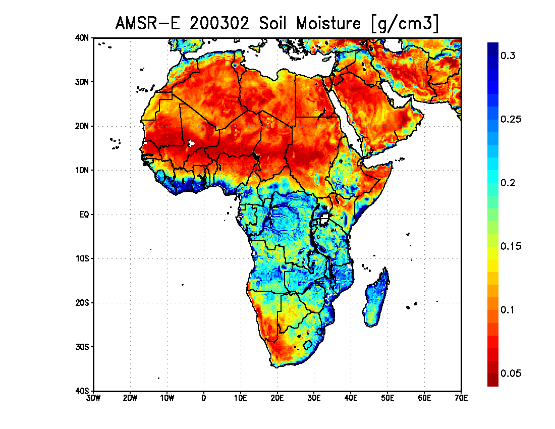
AMSR-E 200302 Soil Moisture (2004), http://www.eorc.jaxa.jp/earthview/2004/img/tp040723_01.gif
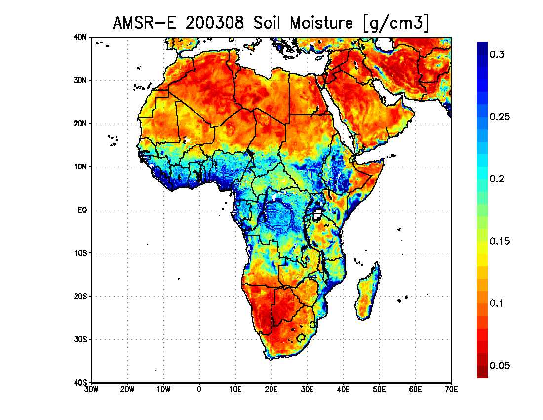
AMSR-E 200308 Soil Moisture (2004) http://www.eorc.jaxa.jp/earthview/2004/img/tp040723_02.gif
J.R. Anderson, E.E. Hardy, J.T. Roach, R.E. Witmer, A land use and land cover classification system for use with remote sensor data. Geological Survey Professional Paper 964 (1976)
D. Antoine, A. Morel, Relative importance of multiple scattering by air molecules and aerosols in forming the atmospheric path radiance in the visible and near-infrared parts of the spectrum. Appl. Opt. 37, 2245–2259 (1998)
Aqua AMSR-E Snow Depth (2011), http://sharaku.eorc.jaxa.jp/AMSR/L3_browse/PM/geo/201103/21/P1AME110321A_P3SWEKel303E0.png
Aquarius L3 Image Browser (2015), http://podaac.jpl.nasa.gov/aquarius/gallery
Arctic sea ice trend (2012), http://www.eorc.jaxa.jp/en/earthview/2012/tp120825.html
I. Asanuma, Depth and time resolved primary productivity model examined for optical properties of water, in Global Climate Change and Response of Carbon Cycle in the Equatorial Pacific and Indian Oeeans and Adjacent Landmasses. Elsevier Oceanogrhy Series (Elsevier, Amsterdam, 2006), pp. 89–106
Australia and Yasi… New floods? … what is SMOS seeing to help forecasts? (2011), http://smsc.cnes.fr/SMOS/GP_actualites.htm
J.T. Bailey, C.G. Boryan, Remote Sensing Applications in Agruculture at the USDA National Agricultural Statistics Service. (2010), http://www.fao.org/fileadmin/templates/ess/documents/meetings_and_workshops/ICAS5/PDF/ICASV_2.1_048_Paper_Bailey.pdf
M.J. Behrenfeld, E. Boss, D.A. Siegel, D.M. Shea, Carbon-based ocean productivity and phytoplankton physiology from space. Global Biogeochem. Cycles 19, GB1006, 1–14 (2005)
R. Below, A. Wirtz, D. Guha-Sapir, Disaster Category Classification and peril Terminology for Operational Purposes (2009). p. 9 http://cred.be/sites/default/files/DisCatClass_264.pdf
P.G. Berenfeld, M.J. Falkowski, Photosynthetic rates derived from satellite-based chlorophyll concentration. Limnol. Oceanogra. 42, 1–20 (1997)
A. Berk, S.L. Bernstein, G.P. Anderson et al., MODTRAN cloud and multiple scattering upgrades with application to AVIRIS. Remote Sensing of Environment 65, 367–375 (1998)
Best Practices for Crop Area Estimation with Remote Sensing Data (2007), http://www.earthobservations.org/documents/cop/ag_gams/200707_01/Summary_countries_AG.pdf
T. Blaschke, G.J. Hay, Object-oriented image analysis and scale-space: theory and methods for modeling and evaluating multi-scale landscape structures. Int. Arch. Photogram. Remote Sensing 34(4/W5), 22–29 (2001)
G. Bo-Cai, M.J. Montes, L. Rong-Rong, H.M. Dierssen, C.O. Davis, An atmospheric correction algorithm for remote sensing of bright coastal waters using MODIS land and ocean channels in the solar spectral region. TGARS 45, 1835–1843 (2007)
I. Buehler, S.A.P. Eriksson, T. Kuhn, A. von Engeln, C. Verdes, ARTS, the atmospheric radiative transfer simulator. J. Quant. Spectrosc. Radiat. Transfer 91, 65–93 (2005)
Carbon Monoxide SCIAMACHY/ENVISAT 2004 (2004), http://www.iup.uni-bremen.de/sciamachy/NIR_NADIR_WFM_DOAS/SCIA_CO_glo_2004.png
M.-E. Carr, M.A. Friedrichs et al., A comparison of global estimates of marine primary production from ocean color. Deep Sea Res 53, 741–770 (2006)
P.S. Chavez Jr., An improved dark-object subtraction technique for atmospheric scattering correction of multispectral data. Remote Sensing Environ 24, 459–479 (1988)
R.M. Chomkoa, H.R. Gordon, S. Maritorenab, D.A. Siegel, Simultaneous retrieval of oceanic and atmospheric parameters for ocean color imagery by spectral optimization: a validation. Remote Sensing Environ 84, 208–220 (2003)
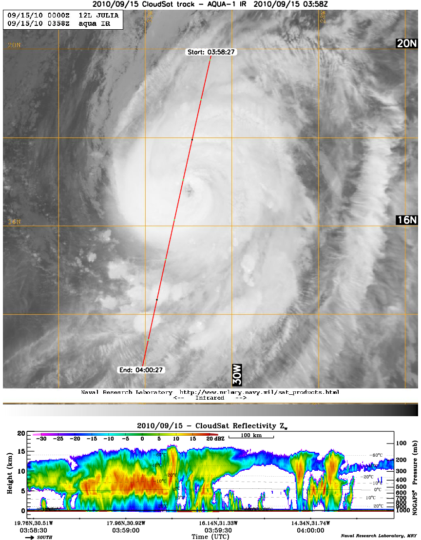
Cloud vertical distribution from Cloudsat (2010), http://cloudsat.atmos.colostate.edu/2010tcs/20100915julia.jpg
S.A. Clough et al., Atmospheric radiative transfer modeling: a summary of the AER codes. J. Quant. Spectrosc. Radiat. Transfer 91, 233–244 (2005)
CO2 flux (2012), https://data.gosat.nies.go.jp/GosatL4Image/dist/browse/L4A/Flux_Map/LatLon/Monthly/CO2/V02.03.000/co2.flux_map.latlon.region.big2.201207.000.v0203.gif
D.P. Craig, T. Thirunamachandran, Third-body mediation of resonance coupling between identical molecules. Chem. Phys. 135, 37–48 (1989)
P.Y. Deschamps, M. Herman, D. Tanre, Modeling of the atmospheric effects and its application to the remote sensing of ocean color. Appl. Opt. 22, 3751–3758 (1983)
Earth Observatory, Absorption Bands and Atmospheric Windows (1999), http://earthobservatory.nasa.gov/Features/RemoteSensing/remote_04.php
Earth Probe TOMS Data & Images (1997), http://toms.gsfc.nasa.gov/eptoms/ep_v8.html
El Niño phenomenon being close to the strongest on record (2015), http://www.eorc.jaxa.jp/en/earthview/2015/tp151130.html
EM-DAT, The International Disaster Database (2016), http://www.emdat.be/
EP/TOMS Version 8 Monthly Average Aerosol Index (1996), ftp://toms.gsfc.nasa.gov/pub/eptoms/images/monthly_averages/aerosol/IM_aiavg_ept_199608.png
ERSDAC. ASTER LEVEL 4A01 DATA PRODUCTS SPECIFICATION (GDS Version) Version 1.1 (ERSDAC Tokyo, 2002)
ERSDAC. ASTER Reference Guide (Version 1.0) (ERSDAC, Tokyo, 2003)
G. Esser, J. Hoffstadt, F. Mack, U. Wittenberg, High-resolution biosphere model (HRBM)- Documentation model version 3.00.00, in Mitteilungen aus dem Institut fur Pflanzenokolgie der Justus-Liebig-Universitat Giessen, ed. by G. Esser, vol 2 (Universitat Giessen, Giessen, 1994)
FAO, FRA 2000 Forest Cover Mapping & Monitoring with NOAA-AVHRR & Other Coarse Spatial Resolution Sensors. Forest Resources Assessment Programme Working Paper 29 (FAO, 2000)
FAO, Land Cover Classification System (LCCS)." 2000. FAO Corporate Document Repository. http://www.fao.org/docrep/003/x0596e/X0596e01i.htm#TopOfPage, http://www.fao.org/docrep/003/x0596e/X0596e01i.htm#TopOfPage
D.R. Fatland, C.S. Lingle, Analysis of the 1993–95 Bering Glacier (Alaska) surge using differential SAR interferometry. J. Glaciol. 4, 532–546 (1998)
J.A. Foley, I.C. Prentice, N. Ramankutty, S. Levis, D. Pollard, S. Sitch, A. Haxeltine, An integrated biosphere model of land surface processes, terrestrial carbon balance, and vegetation dynamics. Global Biogeochem Cycles 10, 603–628 (1996)
C. Frankenberg, A. Butz, G.C. Toon, Disentangling chlorophyll fluorescence from atmospheric scattering effects in O2 A-band spectra of reflected sun-light. GRL 31, (2011), Doi 10.1029/2010GL045896
C. Frankenberg, J.B. Fisher, et al., New global observations of the terrestrial carbon cycle from GOSAT: Patterns of plant fluorescence with gross primary productivity. GRL 31, (2011), Doi 10.1029/2010GL045896
C. Frankenberg, C. O'Dell et al., Prospects for chlorophyll fluorescence remote sensing from the Orbiting Carbon Observatory-2. Remote Sens Environ 147, 1–12 (2014)
K. Fukue, M. Maeda, H. Shimoda, Continental scalse land cover classification using modis surface reflectance products. The international archives of the photogrammetry, remote sensing and spatial information sciences, Vol. XXXVIII, Part 8 (2010). pp. 953–957
GLAS/ICESat L1 and L2 Global Altimetry Data (2014), http://nsidc.org/data/docs/daac/glas_icesat_l1_l2_global_altimetry.gd.html
Global atmospheric temperature at 700 hPa measured by AIRS on Aqua (2009), http://photojournal.jpl.nasa.gov/catalog/PIA12098
Global atmospheric water vapor (total precipitable water) measured by AIRS on Aqua (2009), http://photojournal.jpl.nasa.gov/catalog/PIA12097
Global distributions of HCN and C2H6 showing biomass burning (2003), http://www.imk-asf.kit.edu/english/673.php
Global Fire Map (2016), https://lance.modaps.eosdis.nasa.gov/imagery/firemaps/firemap.2016081-2016090.2048x1024.jpg
Global land cover map (2002), http://earthobservatory.nasa.gov/Newsroom/view.php?id=22585
Global land cover map using MERIS data (2008), http://www.esa.int/esaEO/SEMZ16L26DF_planet_0.html
GLOBCOVER, Products Description and Validation Report (2008), http://due.esrin.esa.int/files/p68/GLOBCOVER_Products_Description_Validation_Report_I2.1.pdf
R.M. Goldstein, H.A. Zebker, C.L. Werner, Satellite radar interferometry: Two-dimensional phase unwrapping. Radio Science 24, 713–720 (1988)
H.R. Gordon, D.K. Clark, Clear water radiances for atmospheric correction of coastal zone color scanner imagery. Appl. Opt. 20, 4175–4180 (1981)
H.R. Gordon, M. Wang, Retrieval of water-leaving radiance and aerosol optical thickness over the oceans with SeaWiFS: a preliminary algorithm. Appl. Opt. 33, 443–452 (1994)
H.R. Gordon, K.J. Voss, "MODIS Normalized Water-leaving Radiance", Algorithm Theoretical Basis Document (MOD18) (2004)
GOSAT Project (2009), http://www.gosat.nies.go.jp/eng/gosat/zu8.htm
A.W. Gruen, Adaptive least squares correlation: a powerful image matching technique. J. Photogram. Remote Sens. Cartography 14, 175–187 (1985)
L. Guanter, C. Frankenberg et al., Retrieval and global assessment of terrestrial chlorophyll fluorescence from GOSAT space measurements. Remote Sens Environ 121, 236–251 (2012)
P. Hofmann, Detecting urban features from IKONOS data using an object-oriented approach. RSPS2001 79–91 (2001)
J. Ishizaka, E. Siswanto, T. Itoh, H. Murakami, Y. Yamaguchi, N. Horimoto, T. Ishimaru, S. Hashimoto, T. Saino, Verification of vertically generalized production model and estimation of primary production in the Sagami Bay, Japan. J. Oceanography 63, 517–524 (2007)
D.J. Jackson, Classical Electrodynamics, 3rd edn. (American Association of Physics Teachers, New York, 1962)
M.Z. Jacobson, The short-term cooling but long-term global warming due to biomass burning. J. Climate 17, 2909–2925 (2004)
N. Jacquinet-Husson, V. Capelle, L. Crépeau, R. Armante, N.A. Scott, A. Chédin,, The GEISA/IASI Spectroscopic database in its 2008 Edition. ISSWG2-2 IASI Sounding Science Working Group, Darmstadt, Allemagne, 21–22 April 2009 (2009)
Japan Association of Remote Sensing. Remote Sensing Graphical Explanation. Japan Association of Surveyors (2001)
Japan Association of Remote Sensing. Remote Sensing Note. Sensing, Japan Association of Remote (1985)
Jason, cycle002, Period:25/01/2002 - 04/02/2002 (2002), http://www.jpl.nasa.gov/images/earth/jason_mer.jpg
JAXA GLOBAL RAINFALL WATCH. 4, 13:00 4 2016. http://sharaku.eorc.jaxa.jp/GSMaP/index.htm
JAXA. MODIS near real time RcRefl (2015), http://kuroshio.eorc.jaxa.jp/ADEOS/mod_nrt_new/1129data/tric/nrt/day/201510/2502/A2GL11510250218OD1_ONLTE_08000_05300_RcRefl.png
Z. Jelenak, T. Mavor, L. Connor, N.-Y. Wang, P. S. Chang, P. Gaiser,. Validation of ocean wind vector retrievals from WindSat polarimetric measurements. The 4th Int. Asian-Pacific Environmental Remote Sensing Conference (2004)
W.L. Jones, L.C. Schroeder, F.J. Wentz, Microwave scatterometer measurements of oceanic wind vector. Proceedings of the Symposium, 26–30 May 1980. Venice, (1981), pp. 553–562
I.R. Joughin, R. Kwok,M.A. Fahnestock, Interferometric estimation of the three dimensional ice-flow velocity vector using ascending and descending passes. TGARS 36, 25–37 (1998)
Y.J. Kaufman, The atmospheric effect on remote sensing and its correction, in Asrar, G. ed. Theory and Application of Optical Remote Sensing (J.W. Sons, NY, 1989), pp. 336–428
G. Kelly, The relative contributions of the various space observing system. 2007 EUMETSAT Meteorological Satellite Conference. EUMETSAT (2007)
Y.S. Kotchenova, F.E. Vermote, R. Matarrese, F.J. Klemm Jr., Validation of a vector version of the 6S radiative transfer code for atmospheric correction of satellite data. Part I: Path Radiance. Appl. Opt. 45, 6762–6774 (2006)
E.R. Kursinski, G.A. Hajj, J.T. Schofield, R.P. Linfield, K.R. Hardy, Observing the earth’s atmosphere with radio occultation measurements using the Global Positioning System. J. Geophys. Res. 102, 23429–23465 (1997)
G. Lagerloef, R. Schmitt, Role of ocean salinity in climate and near-future satellite measurements: Meeting Report. EOS. Trans. Am. Geophys. Union 87, 466–467 (2006)
G.S.E Lagerloef, Introduction to the special section: the role of surface salinity on upper ocean dynamics, air sea interaction and climate. J. Geophy. Res. 107, 8000 (2002)
H.E. Larsen, Ship route planning in Arctic ice infested waters using Near-Real-Time satellite image products (2016), http://www.arcticfrontiers.com/downloads/arctic-frontiers-2016/presentations-4/thursday-28-january-2016/part-iii-technology-needs-1/1301-12-hans-eilif-larsen/file
J.S. Levine, W.S. Cofer, D.R. Jr. Cahoon, E.L. Winstead, The global impact of biomass burning. Environ Sci Technol (1995), pp. 1–55
LIDAR LEVEL1 BROWSE IMAGES - 2011-01-15 01:41:08Z - SECTION2 (2011), http://www-calipso.larc.nasa.gov/products/lidar/browse_images/show_detail.php?s=production&v=V3-01&browse_date=2011-01-15&orbit_time=01-41-08&page=2&granule_name=CAL_LID_L1-V alStage1-V3-01.2011-01-15T01-41-08ZD.hdf
D. Luman, T. Tweddale, Assessment and potential of the 2007 USDA-NASS cropland data layer for statewide annual land cover applications (2008), https://www.ideals.illinois.edu/bitstream/handle/2142/18134/INHS2008_49.pdf?sequenc=1
S.N. Madsen, H.A. Zebker, Imaging radar interferometry. Principles & Applications of Imaging Radar, in Manual of Remote Sensing, 3rd edn. (Wiley, New York, 1998)
E.P. McClain, W.G. Pichel, C.C. Walton, Comparative performance of AVHRR-based multichannel sea surface temperatures. J. Geophy. Res. 90, 11587–11601 (1985)
W.G. Melbourne, et al. The Application of Spaceborne GPS to Atmospheric Limb Sounding and Global Change Monitoring. Pasadena: Jet Propulsion Laboratory, California Institute of Technology (1994)
Mie G, Ann. Physik 377 (1908a)
Mie G, Beiträge zur Optik trüber Medien, speziell kolloidaler Metallösungen. Leipzig, Ann. Phys. 300: 377–445 (1908b)
MODIS Rapid Response System Global Fire Maps (2016), https://lance.modaps.eosdis.nasa.gov/imagery/firemaps/firemap.2016081-2016090.2048x1024.jpg
MODIS Snow Cover Extent (2015), http://kuroshio.eorc.jaxa.jp/JASMES/daily/global/data/CSF10D/201502/MDS20150127_20150205_GLBOD10D_SNWFG_EQ05KM_304.png
J.J. Mohr, N. Reeh, S.N. Madsen, Three dimensional glacial flow and surface elevation measured with radar interferometry. Nature 391, 273–276 (1998)
J.L. Monteith, Solar radiation and productivity in tropical ecosystems. J. Appl. Ecol. 9, 747–766 (1972)
Munich RE, NETCATSERVICE (2015), http://www.munichre.com/en/reinsurance/business/non-life/georisks/natcatservice/default.aspx
Myanmar flood water observation by PALSAR (2008), http://www.eorc.jaxa.jp/en/earthview/2008/tp080509.html
F. Naderi, M.H. Freilich, D.G. Long, Spaceborne radar measurement of wind velocity over the ocean – an overview of the NSCAT scatterometer system. Proceedings of the IEEE 79, 850–866 (1991)
T.Y. Nakajima, A. Higurash, T. Nakajima, S. Fukuda, S. Katagiri, Development of the cloud and aerosol retrieval algorithms for ADEOS-II/GLI mission. Journal of Remote Sensing Society of Japan 29, 60–69 (2009)
T. Nakajima, et al., GSS Reference Handbook (RSTAR Reference Handbook). EORC Bulletin, Technical Report No.15, 360p., ISSN 1346–7913, JAXA/EORC (2004)
NASA RapidScat Proving Valuable for Tropical Cyclones (2015), http://www.jpl.nasa.gov/news/news.php?feature=4562
NASA/JPL, Shuttle Radar Topography Mission (2016), http://www2.jpl.nasa.gov/srtm/
NASA/JPL, SRTM DSM (2004), http://photojournal.jpl.nasa.gov/jpegMod/PIA04965_modest.jpg
R.R. Nemani, C.D. Keeling, H. Hashimoto, W.M. Jolly, S.C. Piper, C.J. Tucker, R.B. Myneni, S.W. Running, Climate-driven increases in global terrestrial net primary production from 1982 to 1999. Science 300, 1560–1563 (2003)
M. Neubert, Segment-based analysis of high resolution satellite and laser scanning data. The 15th International Symposium Informatics for Environmental Protection (Marburg Mtropolis, Zurich, 2001), pp. 379–386
Northeastern China Suffers Large-Scale Flooding (2003), http://www.eorc.jaxa.jp/en/earthview/2003/tp031112.html
Office, US CLIVAR, Report of the US CLIVAR Salinity Working Group. US CLIVAR Report 2007–1 (2007)
S. Perry, F. Kruse, ASTER data use in mining applications, in Land Remote Sensing and Global Environmental Channge, ed. by B. Ramachandran, C.O. Justice, M.J. Abrams (Springer, New York, 2011), p. 315. http://www.jspacesystems.or.jp/ersdac/GDEM/ver2Validation/Appendix_A_ERSDAC_GDEM2_validation_report.pdf
A.B. Pour, M. Hashim, Geological structure mapping of the Bentong-Raub Suture Zone, Peninsular Malaysia using PALSAR Remote Sensing Data. ISPRS Annals Photogram. Remote Sensing Spat. Inf. Sci. 89–92 (2015), http://www.palsar.ersdac.or.jp/data/kouhou/
Primary Productivity of Phytoplankton (2004), http://suzaku.eorc.jaxa.jp/GLI/doc/GLI_BOOK_CD/PDF/CHAP_6.PDF
R.T. Rabus, D.R. Fatland, Comparison of SAR-interferometric and surveyed velocities on a mountain glacier: Black Rapids Glacier, Alaska, U.S.A. J. Glaciol. 46, 119–128 (2000)
L. Rayleigh (John William Strutt) On the light from the sky, its polarization and colour. Philos. Magaz. 107–120, 274–279 (1871)
C.D. Rodgers, Inverse Method for Atmospheric Sounding (World Scientific Pulishing, 2000)
L.S. Rothman, I.E. Gordon, A. Barbe et al., The HITRAN 2008 molecular spectroscopic database. Journal of Quantitative Spectroscopy & Radiative Transfer 110, 533–572 (2009)
Route planning for ships in ice (n.d), http://www.ccrs.nrcan.gc.ca/resource/tutor/gsarcd/pdf/ap_ice_e.pdf
Y.-J. Park, K. Ruddick, Model of remote-sensing reflectance including bidirectional effects for case 1 and case 2 waters. Appl. Opt. 44, 1236–1249 (2005)
D.E. Rumelhart, G.E. Hinton, R.J. Williams, Learning internal representations by error propagation, in Parallel Distributed Processing, ed. by J.L. McCleland, D.E. Rumelhart, The PDP Research group, vol 1 (The MIT Press, Cambridge, MA, 1986a)
D.E. Rumelhart, G.E. Hinton, R.J. Williams, Learning representations by back-propagating errors. Nature 323, 633–636 (1986b)
S.W. Running, S.T. Gower, FOREST-BGC, a general model of forest ecosystem processes for regional applications. II. Dynamic carbon allocation and nitrogen budgets. Tree Physiology 9, 147–160 (1991)
S.W. Running, R.R. Nemani, F.A. Heinsch, M. Zhao, M. Reeves, H. Hashimoto, A continuous satellite–derived measure of global terrestrial primary production. Bioscience 54, 547–560 (2004)
S.W. Running, P.E. Thornton, R. Nemani, J.M. Glassy, Global terrestrial gross and net primary productivity from the Earth Observing System, in Methods in Ecosystem Science, ed. by O. Sala, R. Jackson, H. Mooney (Springer, New York, 2000), pp. 44–57
C. Schaaf, Recent developments in the MODIS Albedo, Nadir BRDF Adjusted Reflectance (NBAR) and Reflectance Anisotropy Products (MCD43) (2010), http://modis.gsfc.nasa.gov/sci_team/meetings/201001/presentations/land/schaaf.pdf
C. Schaaf, A. Strahler, et. al., MODIS Reflectance Albedo and Reflectance Anisotropy. Land and Vegetation Direct Readout workshop (2007)
B. Schölkopf, A. Smola, K.-R. Mülller, Nonlinear Component Analysis as a Kernel Eigenvalue Problem. Tubingen: Technical Report No. 44. Max-Planck Institut für biologische Kybernetik (1996)
SEA SURFACE TEMPERATURE (1 MONTH - AQUA/MODIS) (2015), http://neo.sci.gsfc.nasa.gov/view.php?datasetId=MYD28M&year=2015
D.A. Siegel, M. Wang, S. Maritorena, W. Robinson, Atmospheric correction of satellite ocean color imagery: the black pixel assumption. Appl. Opt. 39, 3582–3590 (2000)
SST and chlorophyll-a distribution and fishing grounds of Sanriku coast Japan, (2003), http://suzaku.eorc.jaxa.jp/GLI/doc/GLI_BOOK_CD/PDF/CHAP_6.PDF
A. Strahler, MODIS land Cover Product Algorithm Theoretical Basis Document (ATBD) Version 5.0. (1999), http://modis.gsfc.nasa.gov/data/atbd/atbd_mod12.pdf
T. Tadono, H. Ishida, F. Oda, S. Naito, K. Minakawa, H. Iwamoto, Precise Global DEM Generation by ALOS PRISM. ISPRS Annals Photogramm Remote Sens Spat Inf Sci II-4, 71–76 (2014)
M. Takagi, H. Shimoda, Handbook of Image Analysis, revised ed. (University of Tokyo Press, Tokyo, 2004a)
M. Takagi, H. Shimoda, Handbook of Image Analysis (in Japanese) (University of Tokyo Press, Tokyo, 2004b)
The land displacement by the 2011 off the Pacific coast of Tohoku Earthquake observed by PALSAR on ALOS (2011), http://www.eorc.jaxa.jp/ALOS/en/img_up/l_dis_inf_tohokueq_110315_f2e.htm
The Mineral Distribution Map near Talc Deposit Area of Mt.Fitton (Australia) using Full Band Data of ASTER (n.d.), http://www.science.aster.ersdac.or.jp/en/topic_image/Geology/001.html
H. Tian, J.M. Melillo, D.W. Kicklighter, A.D. McGuire, J. Helfrich, The sensitivity of terrestrial carbon storage to historical climate variability and atmospheric CO2 in the United States. Tellus 51, 414–452 (1999)
Total NO2 measured by SCIAMACHY on ENVISAT (2011), http://www.temis.nl/airpollution/no2col/data/scia/2011/07/no2trop201107.gif
V. Vapnik, The Nature of Statistical Learning Theory (Springer, New York, 1995)
E.F. Vermote, N. El Saleoql et al., Atmospheric correction of visible to middle-infrared EOS-MODIS data over land surfaces: background, operational algorithm and validation. J. Geophys. Res. Atmos. 102, 17131–17141 (1997)
E.F. Vermote, A. Vermeulen, Atmospheric correction algorithm: spectral (1999), http://modis.gsfc.nasa.gov/data/atbd/atbd_mod08.pdf, http://modis.gsfc.nasa.gov/data/dataprod/dataproducts.php?MOD_NUMBER=09
T. Meissner, F. Wentz, An updated analysis of the ocean surface wind direction signal in passive microwave brightness temperature. IEEE Trans. Geosci. Remote Sensing 40, 1230–1240 (2002)
T. Westberry, M.J. Behrenfeld, D.A. Siegel, E. Boss, Carbon-based primary productivity modeling with vertically resolved photoacclimation. Global Biogeochem. Cycles 22, GB2031 (2008), Doi 10.1029/2007GB003078
Windsat images (2003), http://www.nrl.navy.mil/WindSat/images/wndmap.jpg
XCH4 distribution level3 (2014), http://data.gosat.nies.go.jp/GosatBrowseImage/browseImage/v02XX_L3/XCH4_L3_201404010430_v02.21.png
XCO2 distribution level3 (2014), http://data.gosat.nies.go.jp/GosatBrowseImage/browseImage/v02XX_L3/XCO2_L3_201404010430_v02.21.png
H.A. Zebker, R.M. Goldstein, Topographic mapping from interferometric SAR observations. J. Geophys Res 91, 4993–4999 (1986)
M. Zhao, S. Running, F.A. Heinsch, R. Nemani, Collection 005 change summary for the MODIS land vegetation primary production (17A2/A3) algorithm (2005), http://landweb.nascom.nasa.gov/QA_WWW/forPage/C005_Change_NPP.pdf
Author information
Authors and Affiliations
Corresponding author
Editor information
Editors and Affiliations
Rights and permissions
Copyright information
© 2016 Springer Science+Business Media New York
About this entry
Cite this entry
Shimoda, H. (2016). Remote Sensing Data Applications. In: Pelton, J., Madry, S., Camacho-Lara, S. (eds) Handbook of Satellite Applications. Springer, New York, NY. https://doi.org/10.1007/978-1-4614-6423-5_47-3
Download citation
DOI: https://doi.org/10.1007/978-1-4614-6423-5_47-3
Received:
Accepted:
Published:
Publisher Name: Springer, New York, NY
Online ISBN: 978-1-4614-6423-5
eBook Packages: Springer Reference EngineeringReference Module Computer Science and Engineering
Publish with us
Chapter history
-
Latest
Remote Sensing Data Applications- Published:
- 22 November 2016
DOI: https://doi.org/10.1007/978-1-4614-6423-5_47-4
-
Original
Remote Sensing Data Applications- Published:
- 25 July 2016
DOI: https://doi.org/10.1007/978-1-4614-6423-5_47-3