
Abstract
This chapter reports the results of a study of Acacia Mangium and Acacia Auricaliformis, which are exotic plantation tree species from Australia that have invaded, and spread within, natural habitats in Brunei Darussalam. There are four types of Acacia trees that are spreading in Brunei, mostly within the coastal areas, the deep forest areas as well as in the urban areas in the country’s capital, Bandar Seri Begawan. This study looks into the presently occupied land areas, vegetation cover, land use and landscape changing patterns in the coastal forest areas in Brunei. By clarifying patterns of variation in demographic parameters and hence population growth it is possible to form a connection between qualitative field data, theoretical ideas about invasiveness and rate of spread. The results show that the present growth and expansion rate of the Acacia plant species is alarming for the primary forest as well as for the forest ecology and ecosystems in the coastal forest areas in Brunei. This study makes use of both primary and secondary data sources. The objective of this chapter is to understand the changing patterns of forest vegetation, such as primary forest to secondary forest, and the forest ecosystem in coastal Brunei. Based on this study’s findings some applied recommendations have been proposed for the better distribution of the Acacia plant species and maintenance of rainforest vegetation in Brunei.
Access provided by Autonomous University of Puebla. Download chapter PDF
Keywords
- Brunei coastal area
- Acacia species
- Migration
- Distribution
- Secondary forest
- Invasive species
- Distribution
- Forest Ecology and Ecosystem, Management.
1 Introduction
Brunei Darussalam is a small country located in the north of Borneo, which is an island whose western coastline meets the South China Sea and eastern coastline the Sulu and Celebes Seas (Colonial North Borneo 1953; Brown 1970). Borneo’s coastline is formed mainly of alluvial flats, with many creeks and swamps. Its hills are traversed by valleys and occasional plains. Hills and valleys in most cases are covered with dense forest, and there are many rivers (Colonial North Borneo 1953). The main harbor on the west coast is the island of Labuan, which lies to the north of Brunei Bay. Further north, Jesselton, the capital of the Colony, has a well-sheltered harbor for vessels of moderate size, which take away the bulk of the rubber produced on the west coast (Peter 1998; Tyler 2004). At the most northern point of the Colony is Marudu Bay, a former strong-hold of Illanun pirates on its western shore, and eleven miles from the entrance is Kudat Harbor (Colonial North Borneo 1953).
Brunei has one of the largest tropical rainforest land areas in the world. Over 65% of the land is covered with tropical rainforest, i.e. land with green vegetation, which become part of the hotspots of tropical biodiversity and green spaces in the Southeast Asian region. There are central mountain ranges, from four to six thousand feet in height, rising somewhat sharply from the low-ranging hills nearer to the coast. Brunei has a flat coastal plain along the South China Sea in the western part of the country with some hills further inland (Tyler 2004; Brunei Museum 2005). Mountains rise in the eastern segment of Brunei, which is also the most undeveloped and inaccessible part of the sultanate. An equatorial climate gives the area abundant rainfall, and most of the country remains heavily forested (Figs. 14.1, 14.2, and 14.3), with mangrove swamps within the coastal region.

Topographic view within Champion Deltaic Morphology of Kampong Katimahar, Tutong District, in Brunei Darussalam. (Source: Picture collected by Author 2017)

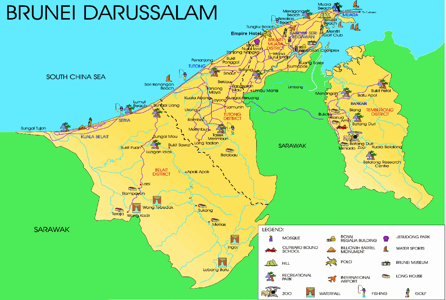
The Geographical location of Brunei Darussalam and Borneo Island in South East
Asian region

The Geographical Location and Characteristics of Brunei Darussalam. (Map Source:http://www.maps-of-the-world.net/maps/maps-of-asia/maps-of-brunei/detailed-tourist-map-of-brunei.jpg)
Brunei consists of four districts: (1) the Belait District in the southwest, which is the largest, (2) the Tutong District in the middle, (3) the Brunei-Muara District that surrounds the capital, Bandar Seri Begawan, and (4) the separate Temburong District in the east (Figs. 14.1, 14.2, and 14.3) (CDD 1993, 2008; Ibrahim 2005; Khatib and Sirat 2005). The population of the country is 423, 200 (as of 2017) and most of the people live in the capital, which is also where its chief port of Muara is located, 25 mi (41 km) to the northeast. Bandar Seri Begawan consists of great contrasts, such as that between the Sultan’s palace, the glittering Sultan Omar Ali Saifuddien Mosque and the world’s largest stilt village, Kampong Ayer. This village, in existence for the past 400 years and provides housing for about 30,000 inhabitants, was declared a national monument in 1987 and is the most popular tourist attraction in the country (Brown 1970:132; Hassan 1988; CDD 1993, 2008; Ibrahim 2005).
The official name of the country is Negara Brunei Darussalam , whereby “Negara Brunei” means the state of Brunei and “Darussalam” means “abode of peace” in Arabic (Colonial North Borneo 1953; CDD 1993). Its full name, Brunei Darussalam, is a compound of a Sanskrit name (possibly meaning “sea people” or is derived from the name of a local tree that also gave its name to the entire island of Borneo) and was added by Muslim sultans in the fifteenth century (Hassan 1988; CDD 1993, 2008; BBYB 2015). Brunei’s 600-year-old monarchy and centuries-spanning history and cultural heritage have been steadfastly upheld to this day (Mahmud 2017).
The total land use pattern shows that only 2.08% land are being used as arable land and 0.87% land are being used for permanent crop cultivation, whereas the remaining 97.05% land are still forest land or are being used for other purposes (2005). The topography of Brunei consists of hilly lowlands in the western region, rugged mountains in the eastern region and swampy tidal plains in the coastal area (Figs. 14.1 and 14.2) (Hassan 1988). Brunei has an equatorial type of climate characterized by high temperatures , high humidity and heavy rainfall (CDD 1993, 2008) (Fig. 14.3) (Hassan 1988). The natural resources are mainly petroleum, natural gases and timber, which are recognized as high potential resources in Brunei.
Mountains of moderately to severely deformed Eocene to Miocene sediments occupy most of the southern part of the Temburong District (Fig. 14.2), including the Forest Reserve (Hutan Simpanan) of Batu Apoi (Earl of Cranbrook and Edwards 1994). The summit levels range from 700–900 m, but reach more than 1000 m at Bukit Tudal (1181 m) and Bukit Retak (1618 m), with the highest elevation in Brunei being Bukit Pagon near the Sarawak border (1850 m) (Earl of Cranbrook and Edwards 1994). Most of the coastal forest region which was totally occupied by rainforest is now degrading in forest density and native plant species are also shrinking. This scenario is observed all over the Brunei coastal forest region.
2 Aim and Objectives
The Acacia trees were initially planted at the farms’ periphery for hedge/shade purposes, as a source of nitrogen supplement and for coastal erosion control. The trees have now encroached on these farms. The aim of this study is to:
-
(i)
Find the use and size structure population, distribution pattern and rates of growth of the Acacia species in the coastal areas in Brunei.
-
(ii)
Investigate the distributional classification of Acacia plants species in Brunei.
-
(iii)
Highlight the Acacia plant species and its ecological impact in Brunei.
-
(iv)
Make recommendations for better management of tropical rainforest vegetation in Brunei, particularly its protection from invasive plant species.
3 Geographical Location and Physiographical Characteristics of Brunei Darussalam
Brunei is located between 4° N and 5.8° N latitudes and, 114.6° E and 115.4° E longitudes on the northwest coast of Borneo (maps shown in Figs. 14.2 and 14.3). The area of the country is 2055 square mi (5770 square km) (land: 5270 sq. km; water: 500 sq. km) (Hassan 1988; CDD 1993, 2008; Ibrahim 2005; Khatib and Sirat 2005; Omar 2005). The country shares a 266 km (165 mi) border along the southern and eastern sides with the Malaysian state of Sarawak, which has an enclave along the Limbang River that splits Brunei into two separate parts (Figs. 14.2 and 14.3) (Brown 1970:132; Hassan 1988; CDD 1993, 2008; Ibrahim 2005; Khatib and Sirat 2005). The country’s 161-km (100 mi) coastline faces the South China Sea from near the mouth of the Baram River in the southwest to the headland of Muara in the northeast (Fig. 14.3).
To the east of Muara is Brunei Bay, a large and protected shallow embayment. Brunei’s tropical climate is seasonal with high temperatures , rainfall is year-round (Turnbull 2017) and climate appears to be highly favorable for the growth of Acacia species (Peter 1998). Figs. 14.2 and 14.3 show the geographical and geomorphological overview of Brunei. Figure 14.3 also displays the four districts’ territorial boundaries and geographical features and landmarks. There are five major rivers that dominate the floodplain morphology in Brunei, namely Brunei River, Belait River, Temburong River, Tutong River, and Pandaruan River. The Brunei River is situated within the three major deltaic regions, which are Baram River Delta , Champion River Delta and Meligan River Delta (UNESCO 1972, 1999, 2004, 2008).
The Baram River Delta has covered most of the southwest corner of the floodplain in the Baram River catchment area and the Champion River Delta has covered the middle part as well as Tutong, Brunei-Muara and the northern part of the Belait District. The Temburong River has covered, and connects most of the Temburong District area (Fig. 14.3) (Hassan 1988; CDD 1993, 2008).
The country as a whole appears as a flat coastal plain that rises to mountainous regions in the east and hilly lowlands in the west (Figs. 14.1, 14.2, and 14.3) (Hassan 1988). As for the elevation of the country, the lowest point is at the South China Sea level, which sits at zero (0) m and the highest point of the country is Bukit Pagon at 1850 m.
4 Importance of and Threats to Forest Resources in Brunei Darussalam
Like many other ecosystems , mangroves provide goods and services for the people and so are an important source especially to the communities living in the coastal areas. Participants from the studied villages understand the importance of mangrove functions and the benefits to their livelihoods, hence, mangrove benefits are listed based on common topics that the participants discussed during the interviews (importance of mangrove benefits; relaxation and recreation; tourist attraction; water filtration and coastal protection; shrimps; crabs ; shellfish; fish; honey; hunting; medicinal purposes; leaves; woods and timber; and fruits). Some benefits, however, are not included, such as spiritual value, due to its vagueness and consequent difficulty in rating its importance as found during the pilot study. Nevertheless, it will not be overlooked in this study as it will be discussed in the following subtopic (Figs. 14.2 and 14.3). The data also suggests that the community is aware of the ecological function of mangroves and the cultural services that they provide, even though the categories are limited and specific compared to more scientific categories. Regardless, it shows that the people have a significant understanding of the importance of the mangrove ecosystem and the benefits it provides (Islam 2014; Siti NorAqilah 2017).
It is clear that people are less dependent on mangrove forest resources compared to fishery resources. This could be the reason people collect mangrove forest resources less frequently than they do fishery resources. Development and modernization could also be important factors causing the lower dependency on forest resources due to the increasing number of different construction material, adequate healthcare in Brunei, better access to different sources of nutrition as well as changing preferences (Siti NorAqilah 2017). Additionally, activities such as hunting and honey harvesting are less significant since the fauna in Brunei is limited compared to that in other mangrove forests such as Sundarban Mangrove in India and Bangladesh . Also, honey harvesting is less-practiced due to the value of the mangrove forest (Siti NorAqilah 2017). People believe that honey harvesting is damaging to the forest and leads to the degradation of its ecosystem. It was also found that the residents understand the ecological functions of the mangrove as a water filtration system, as coastal protection, as well as its aesthetic value for recreation and tourism (Siti NorAqilah 2017). This could also be a contributing factor for showing certain appreciation for the mangrove forest or rainforest as they have an understanding of, and relationship with, the forest. The native plant species in Brunei play significant roles in maintaining the balance in the local ecology as well as supporting the community’s livelihoods, many of which depend on the native medicinal plant species (Peter 1998; The Brunei museums 2005). However, these species are now under threat as coastal forests in Brunei are degrading due to the spread of the invasive Acacia plant species.
5 Climate, Weather and River System in Brunei Darussalam
The climate in Brunei is tropical equatorial and humid subtropical at higher altitudes with heavy rainfall. Brunei has two seasons (Yogerst 1994; Islam 2014), whereby the dry season is extremely hot (24–36 °C or 75.2–96.8 °F) and the rainy season is generally warm and wet (20–28 °C or 68.0–82.4 °F). The following shows the regional climate characteristics of the four districts in Brunei (Brown 1970:132; Hassan 1988; CDD 1993, 2008; Ibrahim 2005):
-
The Brunei-Muara District, where Bandar Seri Begawan is located, is humid tropical on the coast and in the lower-altitude north, whereas the central area of the district is humid subtropical (20–36 °C or 68–97 °F).
-
The Tutong District is tropical – hot in the north and warm in the south. (22–32 °C or 71.6–89.6 °F).
-
The Belait District is tropical – hot in the north and slightly warm in the south. (25–37 °C or 77.0–98.6 °F).
-
The Temburong District is humid subtropical on the higher-altitude south and humid tropical on the coastal and lower-altitude north (18–29 °C or 64–84 °F).
5.1 Climate in Brunei Darussalam
Climatic variations in Brunei follow the influence of the monsoon winds. The northeast monsoon blows from December to March, while the southeast monsoon occurs around June to October (BBY 2014). The total average annual precipitation is an estimated 2722 mm. There are two rainy seasons: from September to January and from May to July (Omar 1981). The temperature is relatively uniform throughout the year, with an annual average of 27.9 °C, ranging from 23.8 to 32.1 °C. The drought months of March and April are the warmest. Owing to high temperatures and rainfall, humidity is high throughout the year with an average of 82% Peter 1998).
5.2 River System in Brunei Darussalam
The Belait, Tutong and Temburong Rivers are the main rivers in Brunei. These rivers and their tributaries are part of two major drainage basins: the Baram drainage basin in the west and the Brunei Bay drainage basin in the east (Fig. 14.3). The Belait River catchment, with an area of approximately 2300 km2, is the largest in Brunei, and is part of the 21,500 km2 Baram basin (Kershaw 2001). Its headwaters are separated from the Baram River by the topographical relief of the Belait anticline (the Belait hills, Fig. 14.3) (Yunos 2011, 2017). The Temburong River drains a basin of some 1100 km2 (nearly the whole of the Temburong District). The Tutong River drains an area of around 1300 km2 in the central part of the country directly into the South China Sea (Mahmud 2017). The Baram River drainage basin and Baram Delta is dominated by the Baram River and its tributaries (Edson 2004). The Baram is one of the larger rivers in Borneo, feeding a delta outbuilding into the South China Sea. The Limbang, Temburong, Trusan, Padas and Klias Rivers are the most important rivers in the Brunei Bay drainage basin. These rivers are smaller, with relatively immature catchment areas. They discharge their sediment load into Brunei Bay.
Figures 14.4 and 14.5 demonstrate the two university campuses which are located in the coastal region of Brunei. The university campuses were built in the dense, native forest areas, and while there are new, on-going developments to the campus, the campus vegetation, as well as the immediate coastal areas, are currently being dominated by invasive Acacia plant species (Figs. 14.2 and 14.3).

Acacia plant species are continuously growing at the coast as well as in the other land areas (Acacia Mangium species in the UBD campus in 2017)

Acacia plant species are now available in everywhere in the coastal forest areas and other parts of land areas (Acacia mangium). (Photo by author 2017: Acacia in the UBD Campus)
6 History of Acacia Species in Brunei Darussalam
The Acacia species are shrubs and trees belonging to the Acacia genus which are native to Australia , Africa, Madagascar, land throughout the Asia-Pacific region and the Americas. The Acacia species can adapt to a wide range of tropical, subtropical and temperate environments, and this adaptability has made them most popular for planting on degraded lands in the Asia-Pacific region and other parts of the world (Turnbull et al. 1997; Turnbull 2017; Figs. 14.6 and 14.7).

The coastal area of Brunei Darussalam and Acacia species are standing as protector of coastal erosion (Acacia mangium). (Photo by author 2017)

The protected coast in South China Sea with huge Acacia Plant Species in Brunei coast, students of Geography and Environmental Studies of UBD, Brunei are investigating biodiversity and environmental coastal wetland characteristics. (Photo by author 2017)
Acacia is a large genus of 1350 different species, which makes it one of the largest plant taxa in the world that can grow in warm, tropical environments and even in deserts. They are most diverse in Australia, with close to 1000 species recorded and are the largest genus of vascular plants in Australia (ANBG 2017). The most popular types of Acacia species based on their physical appearance and special characteristics are flat-topped Acacia, Swollen-thom Acacia, Koa Acacia and flowering Acacia (ANBG 2017; TAS 2017). Figure 14.8 shows the mature Acacia species, which grows scattered around the UBD campus (Figs. 14.4 and 14.5) as well as in the coastal region in Brunei (Figs. 14.6 and 14.7).

Showing the protected coast in South China Sea where the Acacia Plant Species started to grow and students of Geography and Environmental Studies of UBD, Brunei in investigation mode. (Photo by author 2017)
Acacia trees, or in the native language, Pohon jati, are an invasive plant which was introduced as plantation trees to the Borneo island, initially to the Malaysian states of Sabah and Sarawak in the early 1980s and then in Brunei in the early 1990s (Turnbull et al. 1997).
7 Acacia Plant Species in the Coastal Region in Brunei Darussalam
Brunei is one of the regions the world with high forest cover where tropical forests covering 75% of the country’s total land area (Forest Department 2009). The Acacia species was first introduced to the country when Acacia Mangium was first planted to produce high-quality wood for the timber industry (Turnbull and Crompton 1998; Turnbull 2017).
Acacia Mangium was introduced in Brunei for production of timber and furniture. It was also planted for restoration of forest lost during the construction of the 40-km Tutong to Muara coastal highway. The road connects the capital city of Brunei, Bandar Seri Begawan, to regional towns in the Tutong and Belait Districts. Figures 14.9, 14.10, 14.11, 14.12, 14.13, 14.14, and 14.15 display the plantation, distribution and growth pattern of the Acacia species in the coastal region in Brunei. It was determined that the chosen Acacia trees, Acacia Mangium, Acacia Cincinnata and Acacia Auriculiformis , were planted along the highway as they are fast-growing trees that can prevent soil eroding on the highway barrier, which was becoming an environmental problem (Osunkoya et al. 2005; Forest Department 2009).

The Api-Api wetlands area in the coastal region in Brunei with wetland forest where acacia plant species are gradually establishing acacia forest in Api-Api wetland area. (Photo by author 2017)

The Api-Api wetland area in the coast in South China Sea with Acacia Plant Species in Brunei coast (Acacia cincinnata). (Photo by author 2017)

The protected coast in South China Sea with huge Acacia Plant Species in Brunei coast and students of Geography and Environmental Studies of UBD, Brunei investigating biodiversity and environmental coastal wetland characteristics (Acacia auriculiformis). (Photo by author 2017)

The newly protected coast in South China Sea with Acacia Plant Species in Brunei coast. (Photo by author 2017)

Acacia Plant Species densely growing in the UBD Campus (Acacia Auriculiformis). (Picture Source by author 2017)

Acacia Plant Species densely fast growing trees in the every corner of UBD campus (Acacia holosericea in Brunei Darussalam). (Source: Photo by author 2017)

The Api-Api Wetland Forest area in Muara District of Brunei Darussalam an area dominated by Acacia invasive plant species and students of Geography and Environmental Studies of UBD, Brunei investigating biodiversity and forest characteristics. (Photo by author 2017)
Figures 14.9, 14.10, 14.11, 14.12, and 14.15 show the coastal wetlands and forest areas where the students investigated the wetland, forest ecosystem and ecosystem services . Under the module wetland ecology and management a field trip was organized at the Api- Api Forest wetlands areas in Brunei Muara District in Brunei Darussalam. The coastal forest biodiversity issue was also one of the focal points of investigation for the Bachelor students in Geography and Environmental Studies at the University of Brunei Darussalam. The Acacia, other invasive plants and animals were also investigated in the Api-Api coastal forest wetland areas (Figs. 14.9 and 14.10) in the Brunei-Muara District. Initially, the Api-Api wetland and forest areas (Figs. 14.9, 14.10, and 14.12) were highly dense rainforest areas and were of primary forest status in the Brunei-Muara District. However, their characteristics are rapidly changing, and as a result, at present the status of the forest areas in the coastal region is becoming secondary. The students were also investigated the invasive plant species and biodiversity status in forest wetland areas in the coastal wetland areas (Figs. 14.8, 14.9, 14.10, and 14.11).
In the mid-1990s, two other fast-growing species , Acacia auriculiformis and Acacia cincinnata, were cultivated along with Acacia mangium to rehabilitate vegetation along the Tutong-Muara highway to prevent soil erosion (Osunkoya et al. 2005). The plantation of the Acacia species in the Brunei coastal region went very well as these species can grow at very fast rates by protective nitrogen and thus can grow and establish themselves even in nutrient-poor soils. These planted species managed to reduce the soil erosion problem as well as closed up the open canopy along the coastal highway in Brunei. But the Acacia species have spread to other habitats in Brunei, particularly in degraded forests and lands, and they are commonly seen as roadside vegetation throughout Brunei (Osunkoya et al. 2005). There are four species of the Acacia currently found in Brunei, namely (i) Acacia Mangium (Figs. 14.5 and 14.15), (ii) Acacia auriculiformis (Figs. 14.11 and 14.13), (iii) Acacia cincinnata (Fig. 14.10), and (iv) Acacia holosericea (Fig. 14.14). Of these, Acacia mangium appears to be abundant, Acacia auriculiformis and Acacia cincinnata are fairly abundant, whereas Acacia holosericea is less commonly found in Brunei.
8 Uses and Potentiality of Acacia Species in Bioenergy Generation
Acacia wood is suitable for making paper pulp or even woodchips. The wood can also be useful for making furniture. As it is a very fast-growing tree, more bark can be extracted, hence increasing the production of timber (Turnbull et al. 1998). Additionally, the bark of the Acacia trees can be made into firewood as it has a very high affinity to fire. The leaves of the tree can be used as forage and the fallen leaves can be collected to produce fuel. Another use for the bark is for the collection of Acacia mangium honey (Lemmens et al. 1995).
Furthermore, the Acacia species meet the criteria to be seen as an ideal energy crop, criteria which were set by McKendry in 2002. Benefits include (i) high yield of biomass per hectare, (ii) less energy impact to grow, (iii) minimum cost requirement for cultivation, and (iv) production of biomass with minimum contaminants and minimum external nutrient requirements to grow (Mckendry 2002). As an alternative management solution to this Acacia invasion, these Acacia can potentially be used to provide biomass supply for bioenergy production through thermochemical conversion processes. The standing biomass of the species per area could be estimated by the harvest method or by using allomatic equations, which are an effective way of estimating the biomass of trees (MacDicken 1997). The Acacia species would also need to show a satisfactory quantity of biomass production per hectare to ensure the sustainability of the feedstock for biofuels production processes. As the Acacia species are evergreen trees and can generate large quantities of biomass per annum, the potential of this management solution is noteworthy. Acacia mangium can grow up to 30 m in height with a straight trunk and the colour of the bark varies from pale grey-brown to brown. The mature Acacia mangium tree can reach up to 60 m. Mature Acacia mangium trees drop their leaves and instead the stalks are modified into leaf-like structures called phyllodes which are found to be 25 cm in length and 10 cm in breadth approximately, depending on the growing soil conditions (Turnbull et al. 1997; Turnbull 2017). On the whole, the Acacia plant species could help to generate bioenergy, wood supply, honey collection and, considering the rapid fast growing tendency of the Acacia forest in Brunei, could even help to protect the country’s energy sector. This bioenergy generation could be a considerable benefit from the increasingly spreading Acacia plant species in Brunei.
9 Results and Discussion
The long-term national development plan by the government of Brunei – also known as “Brunei Vision 2035” – aims to reduce energy intensity by 45% (with 2005 as the base year) and to generate 10% of energy requirements from renewable resources (APER 2012). As the Acacia species have been able to successfully establish themselves in degraded habitats in Brunei, and the Acacia mangium and Acacia auriculiformis in particular can exhibit high biomass production within a few years of their growth, they could potentially help Brunei in achieving its aims to reduce CO2 emissions whilst also ensuring that the country’s biodiversity is not adversely impacted by their invasiveness (Ahmed et al. 2018).
The Brunei-Muara District in particular has been impacted negatively by the Acacia plant species’ rapid growth and high density. This has been overserved in the Api -Api coastal forest wetland area in Brunei. After the investigation it has been stated by the students and interviewees in the case area where they stated that the primary forest status are reducing and Acacia is spreading very fast in the case area.
Under this Acacia plant species project some interviews were arranged with academic experts and professional peoples those are involved with plants and forest resources as well with Acacia species. Within this initiative Mrs. Rosle was selected as one of the interviewees who is a traditional medicinal plants practitioner in Brunei and living in the coastal area in Brunei. This has been observed in the areas surrounding Ms. Rosle’s (a medicinal garden owner in Brunei Muara District) home garden. She explained that the Acacia species is a danger to all other plant species that are in her home garden. Ms. Rosle is a traditional medicinal plant practitioner in the Brunei-Muara District. Her family has more than 200 years’ worth of indigenous knowledge and experience in the traditional practices of medicinal plant species. She had a medicinal plant garden with more than 100 medicinal plant species available. According to Ms. Rosle, she noticed 5 years ago that some Acacia mangium plants were starting to grow in her garden. She observed that within 2 years, the plant species gradually formed a huge shadow that eventually engulfed the whole garden. Within 2 years she lost 16 different medicinal and native plant species that were very rare and valuable such as special of banana trees. It was a great loss to her business and she was still, at the time of interview, trying to recover and restore her garden to its former condition prior to the invasion of the Acacia mangium plants.
One of the ways in which the negative impact of the Acacia species invasion can be curtailed is to make use of the trees, for example, in energy generation. Developing renewable energy will also effect economic growth, which is a positive impact that has been demonstrated in many countries around the world. This is a worthy possibility in the case of Brunei, especially if energy generation as well as entrepreneurships related to the maintenance, management and use of the Acacia species were to be developed. This way, the available biomass resources can be optimally utilized and, at the same time, positively contribute to the growth of the local economy in a number of ways such as creating new employment opportunities in various sectors including engineering, agriculture, transportation and research and development.
Other benefits of Acacia trees are that they can reduce soil erosion and that they can be used as a boundary or as a windbreak. The trees can also fix atmospheric nitrogen and produce a rich harvest of litter, which increases soil biological activity and rehabilitate the physical and chemical properties of the soil (Otsamo et al. 1995). Figure 14.15 shows the Acacia plant species’ secondary forest development process in the Api-Api wetland and forest area in the Brunei-Maura District.
Despite these benefits, it should also be noted that the Acacia plant species can play an influential role in the spread of forest fires (Turnbull et al. 1998). Forest fires (also known as “wildfires” and “wild land fires” in North America and “bushfire” in Australia) are a widespread phenomenon and not unfamiliar to Brunei. A combination of natural and human factors including dry weather conditions, El-Nino, open burning and recreational fires influence the triggering of forest fires. Uncontrollable fires have damaging social and economic effects, such as curtailing valuable or necessary activities relating to forestry, significantly reduce natural resources such as timber, and property loss (Turnbull et al. 1998; Turnbull 2017). A forest fire starts when an oxidizing agent, which is usually oxygen (O2), is resent into the air, which then fuels any substance that can burn the forest areas.
Forest fires also produce haze and this can affect both humans and animals that live nearby the affected forest areas. Haze can induce harmful conditions in humans such as eye inflammation, nasal irritation, throat irritation and inflammation of lung tissue. Forest fires will also cause disturbances to animals living in, or near to, the affected areas, which may cause them to decrease in number due to migration or death. This may ultimately result in some animal species becoming endangered. The biodiversity of the heath forests in Brunei will also be reduced due to haze – invasive plants such as the Acacia species will take advantage of the reduction in heath forest areas in order to thrive since they are capable of growing in various soil nutrient levels .
10 Recommendations and Conclusion
Water and forest are the dominant elements in the geography of Brunei as well as in the human ecology of both Brunei and the whole of coastal northwest Borneo. In Brunei, the settlement patterns, farming, communications and economic activities have been shaped by the geographical patterns of coast and interior jungle. The latter has generally repelled dense settlement, cultural interpretation and patterns of secondary farming whilst the former has been a magnet for trade, settlement, some semblance of urban life and cultural exchange. Since Brunei is centrally-positioned within the Southeast Asian region, its favorable location enables the country to serve as an entrepôt. This facilitates mobility for traders active in other parts of Borneo such as in the eastern and southern regions of the island as well.
The government agencies are only able to partially manage the geographic and coastal environment for the time being. But the overall recent economic, engineering, geomorphological as well as urban developments, and urban morphological changing patterns indicate the future trend of Brunei’s progressing development.
Acacia trees now bring unexpected consequences to Brunei’s biodiversity as it has become as alien invasive species in the country, which was discovered by a research project in University of Brunei Darussalam in 2014 (UBD News 2014). Due to its ability to survive in harsh environmental conditions and its regenerative quality, Acacia was first introduced to Brunei to restore and rehabilitate degraded habitats. But in reality the Acacia’s invasiveness has resulted in significant loss in native plant diversity in coastal forests like Kerangas (make up about 1% of Brunei‘s forests).
The impact of the rapid regeneration of the Acacia species is likely to have huge negative impacts on Brunei forests and biodiversity in general, which threatens primary forests in Brunei. Acacia increases the flammability of an invaded area, which is one of the main causes of forest fires in the coastal forest areas in Brunei. The densest Acacia forest can be found in the coastal areas of Brunei from the Brunei-Muara District to the Belait District; and these coastal forest areas are thus at high risk of forest fires and are declared as fire-prone zones. The areas of local settlement in the coastal areas are also threatened due to the rapid expansion of the Acacia species.
On the whole, this study found that the expanding growth of the Acacia species is a threat to forest biodiversity, forest status, agricultural crops and forest fire safety. From investigations by the International Union for Conservation of Nature (IUCN), it was found that there are six invasive plant species that have already entered Brunei, yet IUCN still did not include the Acacia as an invasive plant species. It is important to address Acacia as the invasive plants in the coastal areas of Brunei that have high growth rates. They also affect other habitats and are prone to fire which causes pollution as well as loss of habitat. There is a need for rehabilitation of the sustainable green forest in Brunei. The present status and the development of four different types of the Acacia plant species in Brunei is gradually creating threats for the coastal native plant species as well as the coastal forest ecology of Brunei, so it must control or use as a biomass feedstock for biofuel or electricity production.
References
ANBG (Australian National Botanic Gardens) (2017) Information about the Acacia species n.d. http://www.anbg.gov.au/acacia/. Accessed 19 Jan 2018
APERC (Asia Pacific Energy Research Centre) (2012) Asia Pacific energy research Centre, Energy demand and supply outlook of Brunei Darussalam 5th edition, 2012
Ahmed A, Bakar MSA, Azad AK, Sukri RS, Mahlia TMI (2018) Potential thermochemical conversion of bioenergy from Acacia species in Brunei Darussalam: a review. Renew Sust Energ Rev 82:3060–3076
BBY – (Borneo Bulletin Yearbook) (2014) Brunei 2035 development, education and health- seeds of success, Brunei Press Sdn Bhd, Bandar Seri Begawan, Brunei Darussalam, pp 1–192
BBYB – (Borneo Bulletin Year Book) (2015) The guide to Brunei Darussalam 2015, Brunei Press Sdn Bhd, BSB, Bandar Seri Begawan, Brunei Darussalam, pp 1–232
Brown DE (1970) Brunei the structure and history of a Borneoan Malay Sultanate. Brunei Museum, The Government Printing Department, Bandar Seri Begawan, Brunei Darussalam
CDD – (Curriculum Development Department) (1993) History for Brunei Darussalam (Secondary 3). EPB Pan Pacific, Singapore, pp 1–144
CDD – (Curriculum Development Department) (2008) History for Brunei Darussalam: sharing our past. (Secondary 1 & 2). EPB Pan Pacific, Singapore, pp 1–108
Cranbrook E, Edwards DS (1994) Belalong: a tropical reinforest, the royal geographical society. J Trop Ecol, London, & Sun Tree Publishing, Singapore 11(2):314
Edson G (2004) Heritage, pride or passion, product or service? Int J Herit Stud 10(4):333–348
Hassan ABH (1988) Elementary geography for Brunei Darussalam. Federal Publications (s). Ltd, Singapore, pp 1–51
Ibrahim HALH (2005) Culture and counter cultural forces in contemporary Brunei Darussalam. In: Thumboo E (ed) Cultures in ASEAN and the 21st century. Uni Press, Singapore, p 22
Islam SN (2014) Biosphere reserve, heritage identity and ecosystem services of Sundarbans transnational site between Bangladesh and India, In: Conference proceeding of world heritage alumni conference from 22–25 October, 2014. pp 224–244. http://www.IAWHA.com/
Kahar SR (2002) Invasion by the exotic Acacia mangium willd in highly degraded health vegetation within Berakas forest Reserve, Brunei, BSc Thesis, Universiti Brunei Darussalam, Brunei Darussalam
Kershaw R (2001) Brunei, Malay, Monarchical, Micro-state. In: Funston J (ed) Government and politics in southeast Asia. Seng Lee Press Ptc Lad, Singapore, pp 1–35
Khatib MABP, Sirat DPHA (2005) Some aspect of the cultural trends for tomorrow’s Brunei-A strategy. In: Thumboo E (ed) Cultures in ASEAN and the 21st century. Uni Press, Singapore, pp 35–49
Lemmens RHMJ, Soerianegara I, Wong WC (1995) Plant resources of South-east Asia no. 5(2). Timber trees: minor commercial timbers. Backhuys Publishers, Leiden, pp 1–655
MacDicken KG (1997) A guide to monitoring carbon storage in forestry and agroforesty projects, 1997. Winrock International Institute for Agricultural Development, Arlington
Mahmud R (2017) The Borneo Bulletin, 16 October 2017 http://borneobulletin.com.bn/new-bridge-a-boon-to-business-commuters/
McKendry P (2002) Energy production from bioenergy (part 1): overview of biomass. Bioresour Technol 2002(83):37–46
Omar M (1981) Archaeological excavations in Protohistoric Brunei. Meseum Brunei, The Government Printing Department, Brunei, pp 1–91
Omar DPHM (2005) The making of a national culture: Brunei’s Experience. In: Thumboo E (ed) Cultures in Asean and the 21st century. Uni Press, Singapore, pp 5–21
Osunkoya OO, Othman FE, Kahar RS (2005) Growth and competition between seedling of an invasive plantation tree, Acacia mangium, and those of a native Borneo heath-forest species, Melastoma beccarianum. Ecol Res 2005(20):205–214
Otsamo A, Adjers G, Hadi TS, Kuusipalo J, Tuomela K, Vuokko R (1995) Effect of site preparation and initial fertilization on the establishment and growth of four plantation tree species used in reforestation of imperata cylindrica (L.) Beauv. dominated grasslands. For Ecol Manag 73:271–277
Peter C (1998) Nature, western attitudes since ancient times. University of California Press Ltd, London, pp 1–17
Siti NorAqilah BHA (2017) Mangrove dependency in Brunei Darussalam: a comparative study of three villages on the Brunei Bay. In: Unpublished Bachelor thesis in the Department of Geography and Environmental Studies, Faculty of Arts and Social Sciences, University of Brunei Darussalam, pp 1–84
The Brunei Museums (2005) The Brunei museums – 40th anniversary of the Brunei museums department (1965–2005). Perletakan Oscar Sdn Bhd, Malaysia, pp 1–115
TFD (The Forestry Department) (2009) The 5th national report to the convention on biological diversity of Brunei Darussalam. Vol. 2009.n.d.
Turnbull JW (2017) Australian Acacias in developing countries. In: Proceedings of an international workshop at foresrty training centre, Gympie, Old, 4–7 August 1986, organized by Australian Centre for International Agricultural Research, printed by Brown Prior anderson Pry Ltd, Victoria, Australia, Proc. no.16, pp 1–196
Turnbull JW, Crompton HR, Pinyopusarerk K (1997) ACIAR proceedings, recent developments in Acacia planting. In: Proceedings of an international workshop held Hanoi, Vietnam, 27–30 october 1997. Hanoi, Vietnam, 1998
Turnbull JW, Midgley SJ, Cossalter C (1998) Tropical acacia planted in Asia: an overview. In: Turnbull JW, Crompton HR, Pinyopusarerk K (eds) Recent developments in Acacia planting, vol 82. ACIAR proceedings, ACIAR, Canberra, pp 14–28
Tyler R (2004) Brunei Darussalam- the marking of a modern nation. Bandar Seri Begawan, pp 1–58
Tylor EB (1991) Primitive culture, vol 1. John Murray, Albemarle Str. W, London
TAS (Types of Acacia Species) (2017) Types of Acacia species based on their physical appearance and special characteristics n.d. http://www.2020site.org/trees/acacia.html. Accessed 12 Dec, 2017
UNESCO- (United Nations Educational Scientific and Cultural Organization) (1972) Convention concerning the protection of the world heritage cultural and natural heritage, Paris
UNESCO- (United Nations Educational Scientific and Cultural Organization) (1999) World Heritage Centre, Report 1999/3. Paris, pp 1–12
UNESCO- (United Nations Educational Scientific and Cultural Organization) (2008) Policy document on the impacts of climate change on world heritage properties. World Heritage Centre, Paris
UNESCO– (United Nations Educational Scientific and Cultural Organization) (2004) Brunei Darussalam UNESCO country programming document 2013–2016. Organized by UNESCO Jakarta in Bandar Seri Begawan, pp 1–31
UBD News- (University of Brunei Darussalam News) (2014) UBD Discovers Acacia’s Threats on Native Kerangas forests
Yogerst J (1994) The Golden legacy-Brunei Darussalam. Syabas, Bandar Seri Begawan, pp 1–205
Yunos R (2011) Our Brunei heritage- a collection of Brunei historical accounts. Perpustakaan Dewan Bahasa dan Pustaka Brunei, Bandar Seri Begawan, pp 1–405
Yunos R (2017) The Golden Islamic heritage of Brunei Darussalam- a collection of selected historical articles. UNISSA Press, Gadong, pp 1–93
Author information
Authors and Affiliations
Corresponding author
Editor information
Editors and Affiliations
Rights and permissions
Copyright information
© 2019 Springer International Publishing AG, part of Springer Nature
About this chapter

Cite this chapter
Islam, S.N., Mohamad, S.M.B.H., Azad, A.K. (2019). Acacia spp.: Invasive Trees Along the Brunei Coast, Borneo. In: Makowski, C., Finkl, C. (eds) Impacts of Invasive Species on Coastal Environments. Coastal Research Library, vol 29. Springer, Cham. https://doi.org/10.1007/978-3-319-91382-7_14
Download citation
DOI: https://doi.org/10.1007/978-3-319-91382-7_14
Published:
Publisher Name: Springer, Cham
Print ISBN: 978-3-319-91381-0
Online ISBN: 978-3-319-91382-7
eBook Packages: Earth and Environmental ScienceEarth and Environmental Science (R0)