
Abstract
This chapter presents key background information on the Aral Sea and its region. The Aral Sea Basin’s geographical setting is discussed, including location, climate, topography, soils, water resources, constituent nations, and basic demographic parameters. Next, the physical characteristics of the Aral Sea (size, depth, hydrochemistry, circulation patterns, temperature characteristics, water balance, etc.) prior to the modern desiccation that began in the 1960s are summarized. This is followed by treatment of level fluctuations of the Aral and their causes prior to the modern drying. The final section is devoted to tracing the most important events in the history of research and exploration of the Aral up to 1960.
Access provided by Autonomous University of Puebla. Download chapter PDF
Keywords
1 Geographical Setting
The Aral Sea is a large lake located in the heart of Central Asia on the Eurasian Continent (Figs. 2.1 and 2.2). Its basin covers a vast area that is variously delineated, estimates range from 1.5 to 2.7 million km2, but I use the World Bank figure of 2.2 million km2 (World Bank 1998, p. 1). The basin is mainly lowland desert (the Karakum, red desert, on the south and west and the Kyzyl-kum, black desert, on the north and east) (Micklin 1991, pp. 2–4). The lowland climate is desert and semi-desert with cold winters and hot summers in the north and central parts and desert with very hot summers and cool winters on the south (Goode’s World Atlas 1982, pp. 8–9). High mountains ring the basin on the east and south (Tian Shan, Pamir, Kopet-Dog), with peaks in the Pamirs over 7,000 m. January temperature averages range from −12 °C on the north to slightly above 0 °C on the south. July averages run from 24 °C on the north to more than 32 °C on the south (Atlas of the USSR 1983, p. 99).

The location of the Former Soviet Central Asia in Eurasia (the outline of the United States is shown for size comparison). Numbers indicate: 1. Kazakstan, 2. Uzbekistan, 3. Kyrgyzstan, 4. Tajikistan, 5. Turkmenistan, 6. Aral Sea (Source: U.S. Dept. of State. “The New States of Central Asia,” INR/GE, 2351, 1993)

Location of Aral Sea Basin in Central Asia (Source: Micklin, P.: The Aral Sea disaster. In: Jeanloz, R. et al. (eds.) Annual Review of Earth and Planetary Sciences, vol. 35, Figure 1, p. 48. Annual Reviews, Palo Alto (2007))
Annual average precipitation in the lowland deserts is from less than 100 mm to the south and east of the Aral Sea to near 200 mm approaching the foothills of the southeastern mountains (Micklin 1991, pp. 2–4). Potential evapotranspiration (PET), a measure of water loss from the soil and plants assuming no moisture deficiency, ranges from 1,000 mm in the north to over 2,250 mm in the extreme south of the desert zone, resulting in severely arid conditions with moisture coefficients (precipitation divided by PET) below 0.10 common. The foothills and valleys of the mountainous south and southeast are substantially more humid with precipitation ranging from 200 to over 500 mm. PET is around 1,500 mm at the desert margins but declines markedly with altitude. Moisture coefficients range from around 0.2 to over 0.6. The high Pamir and Tian Shan ranges are wet with average annual precipitation from 800 to 1,600 mm whereas PET ranges from 1,000 to below 500 mm, giving this zone a marked surplus of moisture. This, in turn, has created large permanent snowfields and glaciers that feed the two major rivers, the Amu Darya and Syr Darya, which flow out across the desert and ultimately reach the Aral Sea.
A variety of soils are found here: serozem (desert), gray-brown desert, meadow, alluvial, sand, takyr (clay) and heavily salinized (Solonets and Solonchak in Russian) (Atlas of the USSR 1983, p. 104). These soils, with the exception of the heavily salinized, can be made agriculturally productive with irrigation. The area that could benefit from irrigation in the Aral Sea Basin has been estimated in excess of 50 million ha (Legostayev 1986), but this is likely a considerable exaggeration.
Although the majority of the Aral Sea Basin is desert, it has substantial water resources. The mountains on its southern and southeastern periphery capture the plentiful precipitation, storing most of it in snowfields and glaciers. Runoff from these, heaviest during the spring thaw, feeds the region’s rivers. Estimated average annual river flow in the Aral Sea Basin is 116 km3. It, in turn, encompasses the drainage basins of the Amu Darya [darya in Turkic means river] and Syr Darya.
The Amu is the most important river within the Aral Sea Basin. Originating among the glaciers and snowfields of the Pamir Mountains of Tajikistan, Kyrgyzstan and Afghanistan, its drainage basin covers 465,000 km2 (Lvovich 1971, Table 2, p. 31). The river flows 2,620 km from the mountains across the Kara-Kum desert and into the Aral Sea. During this journey, the river, or its major tributaries, flow along the borders and across four states: Tajikistan, Afghanistan, Turkmenistan, and Uzbekistan, entering, leaving, and reentering the last two states several times (Fig. 2.2).
Average annual flow from the drainage basin of the Amu is around 79 km3. This includes not only the flow of the Amu Darya and its tributaries but several “terminal” rivers (Zeravshan, Murgab, Tedjen, Kashkadarya) that disappear in the deserts (Micklin 1991, p. 4; Micklin 2000, pp. 6–7). Terminal rivers are not tributary to a body of water (river, lake, or sea). They are common in arid regions where they arise in humid mountainous zones and flow into deserts where evaporation rates are so high they lose all their water. The Amu Darya is an “exotic” river, which hydrologically means that essentially all its flow originates in the well-watered Pamir mountains, but that this flow is substantially diminished by evaporation, transpiration from phreatophytic vegetation (deep-rooted plants that draw water from the zone of saturation) growing along its banks, and bed exfiltration as the river passes across the Kara–Kum desert to the Aral Sea. The Amu Delta accounted for very large flow losses owing to evaporation and transpiration prior to its modern desiccation that began in the 1960s, particularly during the late spring/early summer period of extensive flooding. Because of these, average inflow of the river to the Aral Sea decreased to around 40 km3 from the 62 km3 coming out of the mountains. Tajikistan contributes 80 % of flow generated in the Amu Darya River Basin, followed by Afghanistan (8 %), Uzbekistan (6 %), Kyrgyzstan (3 %) and Turkmenistan and Iran together around 3 % (most of which is formed in Iran).
The Syr Darya flows from the Tian Shan Mountains, located to the north of the Pamirs. The melt of glaciers and snowfields are its main source of water. Its drainage basin covers 462,000 km2. With a length of 3,078 km, it is longer than the Amu Darya (Lvovich 1971, Table 1, p. 31). The river (or its main tributaries the Naryn and Karadarya) flows from Kyrgyzstan into Uzbekistan, then across a narrow strip of Tajikistan that protrudes, thumb like, into Uzbekistan, and finally across Kazakhstan and into the Aral Sea (Micklin 2000, pp. 6–7). Average annual flow of the Syr at 37 km3, is considerably less than that of the Amu. Kyrgyzstan contributes 74 % of river flow, Uzbekistan 11 %, Kazakhstan 12 %, and Tajikistan 3 %. Like the Amu Darya, the Syr Darya is exotic. Prior to the 1960s, flow diminution was substantial during its long journey across the Kyzyl-Kum Desert with less than half (around 15 km3 on an average annual basis) of the water coming from the mountains reaching the Aral Sea.
The Amu, Syr and the terminal rivers in the basin of the Amu Darya provide, on an annual average basis, an estimated 116 km3. Groundwater is an additional water source. Total renewable groundwater resources in the Aral Sea Basin may be 44 km3/year with, perhaps, 16 km3/year (36 %) usable (Micklin 2000, p. 8). Groundwater is a significant contributor to the flow of the Amu Darya and the Syr Darya in those rivers’ headwaters whereas in the desert regions along the middle and lower courses, the rivers are net suppliers of flow to groundwater. Hence, the net addition of groundwater to available basin water resources above and beyond the surface contribution to river flow, although likely positive, is difficult to ascertain.
Today, the basin includes territory of seven independent nations: Uzbekistan, Turkmenistan, Kazakhstan, Afghanistan, Tajikistan, Kyrgyzstan and Iran. Within its bound are found Kzyl-Orda and Chimkent oblasts (the Russian term for large administrative regions, now officially known as oblystar) in southern Kazakhstan, most of Kyrgyzstan with the exception of the northern and northeastern territory (drainage basins of Lake Issyk-Kul and the Chu and Talas rivers), nearly all of Uzbekistan with the exception of a part of the Ust-Urt Plateau situated in the far northeast of the country, all of Tajikistan, the northern part of Afghanistan, a small part of the extreme northeast of Iran, and all but the western one-third of Turkmenistan.
Lands that now constitute five of the seven basin states (Uzbekistan, Kazakhstan, Tajikistan, Turkmenistan, and Kyrgyzstan) were part of the Russian Empire and its successor, the Soviet Union, from the late nineteenth century until the collapse of the USSR in 1991. Eighty three percent of the basin was situated in the Soviet Union and this territory accounted for generation of over 90 % of basin river flow, a large share of which ran to the Aral Sea until the 1970s. Afghanistan and Iran control the residual portion of the basin and contribute together no more than 9 % of river discharge. Neither was ever part of the Soviet State nor the preceding Tsarist Empire.
The population of the basin, not including the portion lying in Iran, was an estimated 45.2 million (37.3 million in the former Soviet Republics and 7.9 million in Afghanistan) in 1996 (Tashkent Institute of Engineers of Irrigation and Agricultural Mechanization and The Aral Sea International Committee, 1998, Table 2.1). The population of the basin reached around 55 million by 2009 (Table 2.1). The majority of the population lives in rural areas, but the basin has a number of cities. The largest of these are Tashkent in Uzbekistan (2,209,647), Ashgabat in Turkmenistan (637,000), and Dushanbe in Tajikistan (704,000) (World Almanac Books 2012, pp. 840, 843, 849).
All of Tajikistan and its population lie within the basin, as do 98 % of the territory and 99.5 % of the population of Uzbekistan (Table 2.1). The basin covers close to 80 % of Turkmenistan where nearly all its people live. Over 70 % of Kyrgyzstan is in the basin and more than half its people reside here. Kazakhstan has 13 % of its territory and 15 % of its population in the basin whereas Afghanistan has 40 % of its area in the basin with 33 % of its population there. Only 2 % of Iranian territory, located in the extreme northeast of the country, is in the basin and only a minute portion of the national population.
A somewhat different picture emerges when we look at the contribution the states make to the basin’s area and population. Clearly dominant is Uzbekistan with 25 % of the area and nearly 50 % of the population in 2009. Furthermore, this nation sits in the middle of the basin (and Central Asia), is the only country with a border on five of the other six basin states (Uzbekistan has no border with Iran), and has a significant area and population in both of the river sub basins of the Aral Sea drainage (the Syr Darya in the north and east and the Amu Darya in the south and west) (Fig. 2.2). Turkmenistan and Kazakhstan each has 21 % of the area and 9 % and 5 % of population, respectively. Afghanistan has 15 % of basin area and 20 % of population. Tajikistan and Kyrgyzstan are equal at 8 % of area but the former has 13 % of the population whereas the latter has only 5 %. Iran, again, trails far behind the rest with 2 % of the basin area and probably even a smaller a share of the population.
The Aral Sea Basin has great strategic importance. It is the heartland of Central Asia. One or more of the basin nations has borders with world powers China and Russia or with politically volatile Iran and Afghanistan. Three of the basin states are fossil fuel rich, Kazakhstan with oil and Turkmenistan and Uzbekistan with natural gas. Uzbekistan annually produces about 3.5 million tons of raw cotton making it the sixth largest producer of cotton in the world while in 2010 it exported more than 600,000 t of fiber, second in the world (Uzbekistan Investment Guide 2012). Uzbekistan also has large reserves of gold and uranium. Since independence, these resources have garnered the attention and investments of the Western developed nations and China.
Water is of critical importance in this largely arid region. Agriculture remains the dominant economic activity here and is heavily dependent on extensive irrigation, with attendant application of huge quantities of water (see Chap 8 for a detailed treatment of irrigation). Irrigation has strained the basins water resources to the limit and led to conflict among the basin states over equitable water sharing. Irrigation has also been the prime factor in the desiccation of the Aral Sea – once one of the world’s most important lakes. Hence, the management of this key natural resource is of utmost importance to the economic, political, and ecological future of the region.
2 Physical Characteristics of the Aral Sea Prior to the Modern Desiccation
The Aral Sea (in Russian “Aralskoye more” and in Turkic languages of Central Asia “Aral Tengizi (Kazak) or Arol Dengizi” (Uzbek)) is a terminal lake, also known as an endorheic lake, lying at the bottom of the Turan Depression by the eastern edge of the Ust-Urt Plateau (Bortnik and Chistyayeva 1990, p. 6). Its name comes from the word Aral, which means, “Island”. Many believe it was called Aral because it was an “island of water” in the vastness of the Central Asian deserts (Ashirbekov and Zonn 2003, p. 6). Others connect the name to the many islands present in the sea prior to its modern desiccation.
The Aral Sea occupies the lowest part of a vast erosional-tectonic hollow of middle Cenozoic age (Rubanov et al. 1987, p. 27). Geologically it is surprisingly young, having arisen at the end of the Quaternary period, coincident with the last glacial epoch about 10,000–20,000 years B.P., with the likelihood its age is closer to the former than later figure (Oreshkin 1990, p. 3; Kosarev 1975, p. 17). Terminal lakes lack surface outflow; hence, the balance between river inflow and net evaporation (surface evaporation minus surface precipitation) mainly determines their level. Such water bodies are typically saline and can range from hyper saline, such as the Great Salt Lake in the western United States with salinity around 300 g/l (grams/liter) to brackish at around 10 g/l such as the Aral Sea was prior to its modern desiccation that began in the early 1960s.
With an average annual level near 53 m for the period of instrumental measurement (1911–1960) that preceeded the beginning of the modern desiccation in the early 1960s, the lake had an area of 66,086 km2 and was the world’s fourth largest inland water body according to surface area (Table 2.2) (Bortnik and Chistyayeva 1990, pp. 6–9; Rubanov et al. 1987, p. 7). The Caspian Sea in Eurasia (371,000 km2), Lake Superior in North America (82,414 km2) and Lake Victoria in Africa (69,485 km2) exceeded the Aral in surface area. The Aral’s level is measured above the level of the Kronstadt gauge in the Gulf of Finland near St. Petersburg and has a “zero” about 20 cm above ocean level. The Aral had a maximum depth of 69 m, volume of 1,064 km3, average depth of 16 m and shoreline stretching for more than 4,430 km. The lake was elongated in a southwest to northeast direction with a maximum distance of 432 km and a maximum and average width, respectively, of 432 and 156 km. More than 1,100 islands, with an aggregate area of 2,235 km2 dotted the sea. The largest were Kokaral (311 km2), Barsakelmes (170 km2) and Vozrozhdeniya (170 km2) (Kosarev 1975, p. 23).
The Aral was divided into a so-called “Small Sea” (in Russian “Maloye more”) on the north and “Large Sea” (in Russian “Bolshoye more”) to the south, which were connected by the Berg Strait. The Small Aral had an area of 5,992 km2, volume of 80 km3, maximum depth of 29 m and average depth of 13.3 m (Table 2.2). It consisted of a deeper central basin and several shallower gulfs (Butakov, Shevchenko, and Saryshaganak). The largest town and most important port and fishing center (Aralsk) was situated at the northern end of Saryshaganak.
The Large Aral had a considerably greater surface area and volume (60,000 km2 and 984 km3). It was divided into two basins by a north–south stretching underwater ridge that protruded through the surface to form a chain of small islands, the largest of which was named Vozrozhdeniye (“Resurrection”). This Island become famous, perhaps better to say “infamous,” as the location of the USSR’s most important, super-secret testing grounds for biological weapons. The Eastern Basin had an area of 46,466 km2 and the Western 13,628. However, the former was shallow (maximum depth of 28 m and average depth of 14.7 m) whereas the eastern was considerably deeper with a maximum depth of 69 m and average depth of 22.2 m (Aral Sea 1981). The southeastern part of the Eastern Basin, known as the Akpetkinsk archipelago, was very shallow (predominate depths of 2–3 m) and contained more than 500 small islands (Kosarev 1975, p. 23).
The estimated average annual water balance for the Aral Sea for 1911–1960 (considered the quasi-stationary period for the Aral’s level) is shown below (Bortnik and Chistyayeva 1990, Table 4.1, p. 36, Fig. 2.5, p. 20, pp. 34–39).
-
1.
Gain: river inflow (56 km3) + sea surface precipitation (9.1 km3) = 65.1 km3
-
2.
Loss: sea surface evaporation = 66.1 km3
-
3.
Volume change = (−1.0 km3)
Clearly, the main elements determining the Aral’s level, area, and volume are river inflow and surface evaporation, with sea surface precipitation playing a secondary role on the gain side of the balance. There was also a net groundwater inflow, but it was believed small (up to 3.4 km3) and ignored in calculating the sea’s water budget.
Precipitation on the sea’s surface derived from measurements at shore and island stations averaged 138 mm/year, but was greatest on the Small Aral (120–125 mm) and least for the southern portion of the large Aral (105 mm) (Bortnik and Chistyayeva 1990, Fig. 2.5, p. 20). Evaporation, calculated from formulae using atmospheric humidity, water and air temperature, and wind speed measurements, was estimated to be around 1 m, with the maximums reached in the shallow, southeastern part of the eastern Basin of the Large Sea (1,200–1,300 mm) and the minimum on the northeastern part of the Small Aral in the Gulf of Saryshaganak (700–800 mm) (Kosarev 1975, p. 29).
The Aral Sea prior to its modern desiccation was brackish with an average salinity around 10 g/l, slightly less than one-third that of the open ocean (35 g/l). The chief salts were sodium chloride (NaCl – 54 %), magnesium sulfate (MgSO4 – 26 %), and calcium sulfate (CaSO4 – 15 %) (Zenkevich 1963, p. 511). The Aral was closer in its chemical composition to fresh rather than ocean water. Surface salinity was lower than the average near the entrance of the two main rivers (Amu in the south and Syr in the northeast), particularly during peak river inflow in spring/early summer when it could fall below 4 g/l near the mouth of the Amu. High salinity levels (17–18 g/l) were reached during summer and winter in the gulfs of the east and southeast part of the Large Aral owing to high rates of evaporation during summer and ice formation (which releases large amounts of salts) in winter (Kosarev 1975 p. 228). Levels of salinity in isolated portions of the Gulf of Saryshaganak (Small Aral Sea) in the early 1950s reached 80–150 g/l.
The Aral Sea, lying between 43° and 47° N. latitude in the heart of the Eurasian continent with no topographic barriers between it and Western Siberia to the north, is subject to severe winters. Average January temperatures range from −12 °C over the Small Sea to −6 °C on the south of the Large Aral (Bortnik and Chistyayeva 1990, Fig. 2.2, p. 14). Consequently, the sea developed an extensive ice cover. The date of first ice obviously depends on the severity of the winter in a particular year, but commonly freezing began on the north Aral (Small Aral Sea) in late November and spread to the coastal areas of the Large (southern) Aral across 2–3 weeks (Zenkevich 1963, p. 511; Kosarev 1975, p. 244; Bortnik and Chistyayeva 1990, pp. 50–60). However, the open parts of the Large Sea during an average winter remained open. Maximum ice extent and thickness (up to 1 m on the Small Aral during severe winters) was reached in mid-February. Breakup of the ice cover began in the second half of February to the first half of March. Full melting of the ice cover took place from the end of March on the south and southeast Aral to the middle of April on the north.
Several other physical characteristics of the Aral prior to its modern drying deserve mention. The current pattern of the sea was unusual (Kosarev 1975, pp. 213–215; Zenkevich 1963, p. 510). It was anticyclonic (clockwise) whereas most large water bodies of the northern hemisphere have cyclonic circulation owing to the coriolis force of the earth’s rotation that turns moving objects to the left of their direction of motion. The accepted explanation for this is the predominance of northerly winds and the sea’s bottom relief. Another factor that may have played a role is the inflow of the Amu along the western side of the Large Sea to the north and the inflow of the Syr Darya along the eastern side of the Large Sea to the South. However, strong winds from any direction could overcome this circulation pattern. Along the shallow eastern coast of the Aral, where the slope of the bottom and shore were nearly flat, strong winds could rapidly force water some distance inland with an on-shore direction or drive water far from the shore with wind from the opposite direction.
Researchers considered Aral water exceptionally transparent (Zenkevich 1963, p. 510). On average, a Secchi disk, used to determine this, could be seen at 8.2 m, with maximum readings of 23.5 m in the central part of the Large Aral, 24 m in the Small Aral, and 27 m in Chernishov Gulf at the northern end of the Western Basin of the Large Sea (Bortnik and Chistyayeva 1990, p. 95).
A generally shallow water body, sitting in the midst of continental deserts, with high summer temperatures, the Aral Sea accumulated considerable heat during the warm season. Maximum temperatures were reached in July and August, when the surface layer along the shoreline could reach 29 °C and 24–26 °C in the open sea (Zenkevich 1963, Table 236, p. 510; Bortnik and Chistyayeva 1990, pp. 43–49). As heating of the water mass progressed, a significant thermocline and temperature discontinuity formed in the deep Western Basin of the Large Sea, where the surface temperature would average around 24 °C while at depths below 30 m it would range from 2 °C to 6 °C. The shallower Eastern Basin of the Large Sea, on the other hand, had relatively uniform temperatures throughout the water column, with a difference of only a few degrees between the surface and bottom.
Finally, a few words about vertical stability and convective mixing of the Aral Sea are in order (Bortnik and Chistyayeva 1990, pp. 82–85; Kosarev 1975, pp. 237–240, 247–260). For the Aral, the former was primarily determined by temperature and only in the southern parts of the sea by both temperature and salinity. Intensive heating of the Aral’s surface waters in spring and summer led to the formation of a stable surface layer (down to the temperature discontinuity) and a stable bottom layer below that. Hence mixing between the surface and bottom layers was prevented. With the onset of cooling in fall, the surface to bottom temperature gradient weakened considerably, sometimes turning negative, leading to greatly diminished stability and convective mixing. During winter, ice formation and the resulting salt rejection increased surface water layer density and further enhanced convective mixing. Kosarev (1975, p. 247) considered the fall-winter convective mixing, which affected all parts of the sea and encompassed all water layers, the most important process determining the hydrologic structure of the Aral waters, particularly for the deeper parts of the sea.
3 Level Fluctuations Prior to the Modern Desiccation (also see Chap 4)
Over geologic time, the Aral depression has repeatedly been flooded and desiccated (Zenkevich 1963, pp. 277–297) . Rubanov (Aladin et al. 1996) considered that the Aral Sea Basin first formed about three million years ago, in the late Neogene period. Two key questions are how was the Aral Basin formed and second, how did it fill with water? Most experts believe that it began as a small depression, which collected local surface water. This runoff was slightly saline due to the dissolution of local salt deposits. When the water evaporated, it left behind a thin veneer of salts. The surface layer was highly sensitive to wind erosion. Repeated over and over again, this process eventually deepened and enlarged the depression. Subsequent discharge of the ‘proto’ Amu Darya into the basin from the south resulted in the deposition of sediments that divided the main basin into two smaller ones, the Sarykamysh Basin to the southwest and the Aral Basin to the northeast.
Kes (1978), based on Uranium isotope ratio dating, set the first significant filling of the Aral depression in the late Pleistocene, approximately 140,000 years B.P. (before present), when the Syr Darya, entering from the east, filled the lowest parts of the hollow (the Western Basin of the Large Sea, and, possibly, the deepest parts of the Eastern Basin). Other experts have placed the original filling stage of the Aral from 100,000 to 120,000 years B.P. (Oreshkin 1990, pp. 3–4). At this time and for a considerable period afterward, the Amu River flowed westward into the Caspian Sea rather than northward into the Aral.
The lake did not attain great size, i.e., its modern pre-desiccation form, until the Amu Darya switched its course northward into the Aral. This increased inflow to the lake by some threefold. The rate of accumulation of sand and sediments in the Amu Darya Delta has been employed to determine when this occurred. The range of estimates is 10,000–20,000 years B.P. The reason for the change in course of the Amu was most likely onset of a wetter climate that increased river flow, flooding the Amu Darya valley with subsequent spilling over into the valley of the Zaravshan River. The uniting of the two rivers led to breaching of low topographic barriers that allowed the Amu to flow northward to the Aral (Aladin et al. 1996). The Small (northern) Aral only filled after the addition of the Amu’s flow.
In any case, approximately the last ten millennia (corresponding with the Holocene geological epoch) constitute the modern history of the Aral Sea. Soviet scientists during the post World War II era (from the late 1940s to 1991s) intensively studied the evolution of the Aral over this time period. Dating of relict shore terraces, of marine fossils and deposits of various salts precipitating from the sea contained in sediment cores from the sea bottom, and of archaeological sites, along with historical records point to repeated major recessions and transgressions of the sea.
One of the most respected researchers, Kes (1978), considered that there was strong evidence for relatively stable levels of some duration at 25–27, 30–31, 35–37, 43–45, and 50–51 m above sea level (asl). Based on terraces, Kes also believed sea level could have been as high as 57–58 m. However, he doubted claims for higher terraces that some say provided evidence for Aral levels of 62–63 or even 70–73 m (Mayev et al. 1991; Rubanov et al. 1987, pp. 51–54). Recent investigations using modern analysis techniques (see below) support Kes and indicate the highest level the Aral reached over the last 10,000 years was no more than 54–55 m asl and that at a sea level of 64–65 m the enlarged Aral would encompass and fill the Sarykamysh depression, leading to overflow into the Uzboy channel leading to the Caspian (Boroffka et al. 2006; Boomer et al. 2009). Hence the maximum level range for the sea over the past ten millennia would appear to be about 20 m.
The early transgressions and regressions of the sea, as you would expect, are not as well known as later events. The so-called Paskevich terrace at about 31 m dates to 9,000–11,000 B.P. and is associated with a shift in the climate of Central Asia from the moist conditions of the late Pleistocene, which led to the initial filling of the Aral Sea depression, to the cold/dry environment of the early Holocene (Aladin et al. 1996; Vinogradov and Mamedov 1991). During this time, evidently, only the Syr Darya fed the Aral, as the Amu flowed westward to the Caspian. This stage switched to warm and relatively moist steppe-like conditions, about 8,000 B.P., as the Amu changed course from the Caspian into the Aral, and the lake’s level rose significantly, perhaps to 57–58 m. Vinogradov and Mamedov (1991) state the Aral rose to 72 m before overflowing to the Caspian, but as indicated above, recent analysis has discredited this level. This phase, known as the Lyavlyakansk pluvial, persisted until about 5,000 B.P. Favorable environmental conditions led to a flourishing of both fauna and flora, including the Auroch (Bos primigenius), a primitive form of cattle. These conditions were conducive to early human settlement, evidence of which has been found broadly distributed in the deserts, along the rivers, and around lakes in the Aral Sea Basin.
The level fluctuation history for the second half of the Holocene (approximately 5,000 B.P. to the beginning of the modern drying in the 1960s) is better understood. Researchers from the Institute of Ethnology and Anthropology in Moscow (Mayeva and Mayev 1991; Mayev et al. 1991) have provided a useful general overview of Aral level changes over this period. It is based primarily on the radiocarbon dating of distinct layers contained in sediment cores taken from the bottom of the Aral, supplemented by information drawn from analyses of terraces. The layers consisted of fine grained carbonate-clay silts, more coarse grained sand and silt, with entrained shells, and sulfate salts, primarily gypsum (CaSO4 .2H2O) and mirabilite (NaSO4 .10H2O).
They identified 19 lithologically different layers, representing nine transgressive-regressive cycles. Radio carbon dating of the carbonate in mollusk shells and remains of organic detritus were used to date the layers laid down when regression was underway. Sea levels and the duration of trangressions and regressions were determined by information on the thickness of layers indicating one or the other process and estimates of at what depths ranges different lithological precipitates were distributed in the modern Aral Sea. The general rule used was that carbonate clays accumulate in deep water conditions, indicative of transgression, whereas sandy layers with shells, especially containing sulfate salts, indicate shallowing conditions, indicating regression.
The cores they used for the analysis date to the beginning of the Holocene, some 10,000 years B.P. But the dating of layers prior to 5,000 B.P. was viewed as so problematic that they confined their analysis to the latter period only. Six of the nine major regression/transgression cycles occurred during this interval (Fig. 2.3). High standings of the Aral have been more common than low with the highest levels, reached 4,000–5,000 B.P., at over 70 m. However, Mayev and Mayeva as others were suspicious of this level based on a purported seashore terrace and, as indicated above, it is physically impossible. The authors also questioned the next highest level of 62–63 m dated to around 3,000 years ago. Probably the highest reliable standing of the sea is the “Ancient Aral Transgression” that reached an estimated 57–58 m asl and lasted from approximately 2,800–2,000 B.P. According to Mayev and Mayeva, there were also high levels of the Aral reached around 1,000 years ago (New Aral at 54–55 m), 800 B.P. (52 m) and, of course, the pre-1960 level around 53 m that dates from around the middle seventeenth century (350 B.P).

Transgressive and regressive stages of the Aral Sea during the Middle and Late Pleistocene (according to Mayev, Mayeva and Karpychev). Legend: (A) Transgressive stage and level in meters above sea level (Based on literary data). (B) Transgressive stage. (C) Regressive stage. (D) Estimate of the regressive stage level in meters above sea level. (E). Layers of the bottom sediments. (F) Radiocarbon age in 1000s of years before present (B.P.) “+” transgressive stage; “−” regressive stage (Source: Modified and redrawn from Mayev et al. (1991), pp. 85–86)
According to these authors, regressions of the sea have been, with one exception, of much shorter duration than transgressions. Probably all of them are related to the partial or full diversion of the Amu Darya westward into the Sarykamysh Depression and from there via the Uzboy channel to the Caspian Sea. The Amu carried a heavy suspended sediment load. Over time, the deposition of sediment built up the bed level and forced the river to break through its left bank and flow to the Sarykamysh Depression and further toward the Caspian. Subsequently, because of heavier flow on the Amu or other natural reasons, the bed sediments would erode, entrenching the river and causing it to resume its northerly flow to the Aral. The change from a wetter to dryer climate leading to less flow into the Aral from both the Syr and Amu no doubt also played a role, but cannot account for the size and rapidity of the most significant level declines.
Ancient civilizations, as well, had an effect on Aral levels. Human impacts included sizable irrigation withdrawals and periodic diversions of the Amu Darya westward into the Sarykamysh Depression and Uzboy channel. The first evidence of irrigation along the Amu dates to 3,000 years ago (Kes 1978; Lunezheva et al. 1987, 1988). Oberhaensli et al. (2007) note that Soviet researchers concluded irrigation during Classical Antiquity (fourth century BC to fourth century AD) was extensive with irrigation canals, some 20 m wide and stretching kilometers, found over 5–10 million ha around the Aral (although Kes based on the work of the well known Russian anthropologist B.V. Andrianov maintains the maximum irrigated area in antiquity never exceeded the former figure). Aladin et al. (1996) present a map showing extensive irrigated areas along both the lower Syr and lower Amu by 1,600 B.P.
However, the impact of ancient irrigation on river inflow to the sea was probably not as significant as it might seem (Kes 1978). Fields were small and withdrawals per ha irrigated were much less than modern. Irrigation was mainly confined to relatively moist low areas in the deltas (branch channels and cut-off parts of the river bed) and along the Amu and Syr. These locations under natural conditions were overgrown with hydrophytes (water lowing vegetation also known as phreatophytes) that transpired huge amounts of water. Replacing them with lower consumptive water use crops of wheat and oats increased flow rather than decreasing it. Also, a much larger percentage of water withdrawn was returned via drainage flows to the rivers rather than being “lost” to evaporation in the arid surrounding deserts. Finally, canals were built and abandoned over time so that the actual area irrigated in a particular season was far smaller than the area covered by canal systems.
Diversions were by far the most important human influence on levels. Some of these were accidental, caused by breaching of dikes and dams constructed for irrigation purposes during heavy flows on the river. Others occurred during wars and were purposeful with the intent to deprive an enemy of both water for drinking and irrigating crops. Thus, in 1,221 the forces of Genghis Khan wrecked irrigation systems in Khorezem to punish the local people for robbing one of his caravans (Oreshkin 1990, pp. 10–11; Oberhaensli et al. 2007). This caused the Amu to turn its course from northward to the Aral to westward into the Sarykamysh Depression and the Caspian. Timur (Tamerlane) in 1406 is reported to have diverted the Amu westward to flood the present day city of Urgench to force its surrender (Letolle et al. 2005). This, again, shifted the course of the Amu toward the Caspian and away from the Aral and is associated with a marked level drop and shrinkage of the Aral, attested to by mirabilite deposits in the Western Basin of the Large Sea. There is ample archeological and historical evidence of repeated settlement and agriculture around the Sarykamysh Depression and along the Uzboy, which would only be possible when both were flooded.
According to Mayeva and Mayev (1991) and Mayev et al. (1991), the most severe and long-lasting drop occurred between approximately 2,000 and 1,200 B.P., with the level perhaps falling as low as 23–27 m. This event was most certainly a result of a full diversion of the Amu westward and away from the Aral, leaving only the Syr Darya to feed the sea. It is also possible that for a time the flow of the Syr to the Aral was significantly diminished or even totally halted owing to its diversion southward into the Kyzyl-Kum Desert via the Zhana Darya channel. The only remaining parts of the water body would, have been the deep Western Basin of the Large Sea, a small, very shallow, and very saline remnant lake in the Eastern Basin of the Large Sea and probably a remnant of the Small Sea consisting of several lakes in the deepest parts of the western part of that water body fed by groundwater and local surface inflow.
Evidence for this stage is the thick mirabilite deposits in the western basins of the Large and Small seas and in Tshche-bas Gulf primarily discovered and dated by the noted Soviet geologist I.V. Rubanov in the 1970s and 1980s (Rubanov et al. 1987, p. 229; Cretaux et al. 2009). However, Rubanov et al. assigned a later date (1,500–1,000 B.P.) to this regression than Mayev and Mayeva and estimated a somewhat higher level (at least a drop to 28 m asl and possibly lower). The presence of thick beds of mirabilite indicates very high salinities according to Rubanov et al. (1987, p. 13), as this salt only begins to precipitate at 150 g/l., and hence low levels that lasted for a considerable period. Later in this phase lake level may have risen to between 30 and 39 m, creating a huge, shallow lake in the Eastern basin that has been named the Oxus Swamp (from the Greek name Oxus for the Amu Darya), which, according to Mayev and Mayeva (1991), was overgrown with phreatophytic (water loving) vegetation and sparingly supplied with water from the Syr and possibly the Amu. The inflow was sufficient to maintain the water body but not raise its level.
Research on the historic level fluctuations of the Aral diminished greatly after the collapse of the USSR at the end of 1991. The lake was no longer of great interest to research institutions in Moscow and Leningrad that had studied it during both Tsarist and Soviet times. Some scientists, particularly Dr. Aladin and Dr. Plotnikov, associate editors of this volume, and their colleagues at the Zoological Institute in St Petersburg (formerly Leningrad) did continue their work. Since the late 1990s, however, there has been a resurgent interest in the topic of past level changes. Two powerful motivating factors have been the need to better understand the modern regression by delving into past drying events and the fact that the receding sea is uncovering shoreline terraces, former river beds, archeological finds, and other evidence whose analysis provides a much clearer picture of past regressions than has hitherto been possible.
The most ambitious recent effort was developed as a subproject of the CLIMAN Project (Holocene climatic variability and evolution of human settlement in the Aral Sea Basin) (http://www.CLIMAN.gfzpotsdam), funded by the European Union’s INTAS Project (1993–2007). INTAS supported cooperative efforts between scientists from European Union countries and scientists from countries of the former USSR. The Aral-related program was intended as an interdisciplinary study to help distinguish between climatic variations and anthropogenically controlled environmental changes in the past (Boroffka et al. 2006; Oberhaensli et al. 2007). The focus was on previous lake-levels and the evolution of human settlement and agriculture in the Aral Sea Basin. Field investigations in 2002 and 2003 conducted geomorphologic surveys to determine prior lake levels as recorded in shoreline marks and terraces created over the past 5,000 years and to relate these to archeological findings. Two sediment cores (6 and 12 m in length) retrieved from Chernishov Bay at the northern end of the Western Basin of the Large Sea in 2002 were used to decipher level changes over the past two millennia.
The researchers investigated both the northern and southern Aral coasts for archeological sites. They used GPS (Geographic Positioning System) equipment to precisely locate any found and attempted to relate these to ancient or modern shorelines. Sites were dated by conventional archeological methods and radiocarbon dating. To better understand Aral level history, the expeditions mapped beaches, terraces, and wave-cut cliffs. Differential GPS, much more accurate than regular GPS, was employed to determine the elevation of paleoshorelines. Landsat ETM (Enhanced Thematic Mapper) images and digital elevation model data were used for analyzing the spatial distribution and vertical position of littoral features at specific locations. Collected data were entered into a GIS (Geographic Information System). Two sediment cores were taken from Chernishov Bay at the northern end of the Western basin of the Large Aral and analized for their lithology.
The surveys found Paleolithic sites dated 50,000–35,000 B.P. near the former northern shore of the Aral. Lying at 60 m asl along the edge of cliffs, these sites were intact and had not been disturbed by wave action or covered by lacustrine (lake) or wind-blown sediments, providing convincing evidence that the Aral’s level was never higher than 60 m. Furthermore, differential GPS elevation measurements made of a number of shorelines around the sea according to the CLIMAN group, convincingly argue against the Aral’s level standing any higher than about 55 m for at least the past 35,000 years.
Kazakh hunters at the end of the twentieth century made an equally important discovery when they came across a mazar (Islamic holy gravesite) in the northern part of the Eastern Large Aral, northeast of the former Island of Barsakelmes, which in the early 1960s was about 18 m below the surface of the Aral (Aladin et al. 2008; Micklin 2006) (Figs. 2.4 and 2.5).Footnote 1 The CLIMAN Aral group found evidence of a village next to this site and dated both to the thirteenth and fourteenth centuries. Bones of humans and domestic animals, ceramics, and other artifacts were also discovered here.

Kerdery 1 Masoleum with relict channel leading off former bed of Syr Darya in the background (Dr. Aladin is sitting by ceramic artifacts; photo by P. Micklin)

Ceramic artifacts found at Kerdery 1 Masoleum (Photo by P. Micklin)
When the editors of this book, along with several other researchers, visited the site during an expedition to the Aral in August 2005, they also noticed clear evidence of a watercourse nearby, probably a relict channel that led off the Syr Darya that then flowed across the dry bottom of the Eastern Aral. This former river bed of the Syr was no doubt a water supply for the local inhabitants and also probably provided inflow to what was left of the Eastern Basin and to the deep Western Basin of the Aral. An analysis of Aral mirabilite deposits by Cretaux et al. (2009) adds weight to this view. The former riverbed of the Syr Darya clearly shows on Landsat imagery from September 11, 2007 and appears to end somewhat north of the former western end of Barsakelmes Island, in waters, which, according to the Soviet 1:500,000 bathymetric map (Aral Sea 1981) were about 22 m deep in the early 1960s (Fig. 2.6). This would indicate a minimum Aral level of about 31 m asl during this regression.

Landsat band 5 Image of 9-11-07 showing late Medieval course of Syr Darya (b on image) on dried bottom of Eastern Basin of Large Aral with sub-channels (a on image is location of Kerdery-1) leading off to the northwest. North is toward the top
The gravesite is known as Kerdery #1. As the sea has retreated in ensuing years, other archeological finds (Kerdery #2–5) have been exposed. What the Kerdery finds and the discovery of the relict channel of the Syr Darya prove is that Aral levels in the thirteenth and fourteenth (and probably into the fifteenth) centuries were very low, but still several meters above levels in 2009, which were around 28 m asl. Two of the editors of this book (Aladin and Plotnikov 2009) and their research group found remains of Saksaul stumps (Haloxylon aphyllum) in the early 1990s when the level of the large Aral was around 37 m. They were radiocarbon dated to the mid 1600s (Aladin et al. 1996). Other Sauksaul stumps have subsequently “appeared” at lower levels but not been dated (Fig. 2.7). Nevertheless, the stumps, remants of Saksaul forests growing around the Aral shoreline, indicate a rising Aral that flooded and killed the trees going back at least to the early seventeenth century and probably considerably earlier.

Preserved stump of late Medieval Sauksaul (Halyoxen apphyllium) near shore of the Western Basin of the Large Aral Sea (September 2005; photo by P. Micklin)
Based on archeological evidence, relict shorelines, and sediment core analyses, the CLIMAN group, delineated seven transgressions and six regressions over the past 5,000 years. However, the best documented of these (by sediment cores analysis and shoreline traces) are four regressions dated to 350–450, 700–780, around 1,400, and 1,600–2,000 years B.P.
The deepest recession identified by them is the late Medieval occurrence associated with the Kerdery archeological finds, which they believe may have lowered the sea to a about 30 m asl – consistent with the evidence from the relict bed of the Syr Darya. Other recessions are estimated to have not lowered the Aral level much below 40 m. The most important contribution of the CLIMAN efforts is reliably establishing the maximum trangression of the Aral at no more than 58 m asl and probably no higher than 55 m and establishing that the thirteenth to fifteenth century recession was much deeper than previously thought. The CLIMAN group also uncovered a previously unknown recession dating to the Bronze Age (4,000–3,000 B.P.) when the lake’s level fell to 42–43 m.
Boomer et al. (2009) provide a useful review of paleoenvironmental research on the Aral, focusing on recent investigations of sediment cores and the insights these provide on level fluctuations over the past 2000 years. Earlier work by Boomer and colleagues based on analysis of two short cores taken from the Small Aral in 1994 suggested the main part of that water body dried for a short period, indicating that sea level fell as much as 30 m, to around 23 m asl, sometime between the late fifteenth and early seventeenth centuries (1440–1640 AD). If this figure is accurate, it would likely tie for the deepest recession of the Aral during the Holocene, the other occurring around 2,000 B.P. according to Mayeva and Mayev (1991). However, it may represent the desiccation of an isolated Northern Aral without inflow as once the entire Aral fell below about 39 m, the southern and northern parts of the sea would separate and the Syr Darya would have only flowed into the Large Aral on the south.
The review goes on to summarize the CLIMAN findings, already discussed above, as well as other research. Boomer et al. (2009) see convincing evidence (from analysis of sediment cores and their organic constituents and historical records) for a significant recession occurring sometime between 0 and 400 AD. They cite climate change to colder, drier conditions that would have reduced river inflow to the sea, along with diversion of the Amu westward toward the Caspian as the primary causes. After about 450 AD, there appears to have been a return to warmer, more moist conditions leading to a rise in Aral levels and a drop in salinity.
The evidence, according to them, points to another significant recessive period from about 1100–1300 AD. The authors contend the causative factor was chiefly climate change with possibly some impacts from expanded irrigation. They discuss the probable diversion of the Amu westward by the Mongol invaders in 1220, but state that based on archeological and core analysis the diversion and recession was short-lived. A new regressive phase initiated sometime between 1440 and 1640 AD. Historical records, sediment core analysis, and radiocarbon dating of Saksaul stumps support this, according to the authors. How low this phase went is not clear, but an undated Saksaul stump, obviously related to this regression, found along the west coast of the Large Aral in Sept. 2005 by the editors of this book (Fig. 2.7) was only a few meters above water level of about 31 m asl, which indicates this was a major event. Boomer et al. (2009) relate the recession to climate change that produced colder and drier conditions in the mountains, reducing the Syr and Amu inflow to the Aral. They discount the idea of human connected diversion of the Amu westward as a cause, but in somewhat of a contradiction, mention that a documented report from the time indicated the Amu’s flow didn’t return to the Aral until 1,573. It is questionable that climate change alone could have produced such a major desiccation.
Following the return of the Amu Darya to the Aral and the sea’s recovery (certainly attained by the mid 1600s) the lake was in a relatively stable, transgressive phase until the modern regression that initiated in the early 1960s. Level fluctuations over this 300-year interval probably were limited to 4–4.5 m asl and were chiefly related to climatic fluctuations with, perhaps, some effect from expanding irrigation (Kes 1978; Bortnik 1996). During high flows on the Amu when its left bank would be breached, some water reached the Sarykamysh Depression. But this phenomenon was rare and brief and had little impact on the level of the Aral.
The famous Russian naturalist/geographer L.S. Berg and later V.P. Lvov studied the history of the Aral’s level over recent centuries using literary and cartographic sources (Berg 1908; Lvov 1959). Berg and Lvov identified a sequence of high and low stages, lasting 50–60 years. According to them until the mid 1700s, lake level was in a high phase (53 m). A lower standing followed, reaching its nadir according to Rogov (1957, Fig. 72, p. 196) at 49 m in 1824. Based on two accurate maps of the sea compiled in the late 1840s (Butakov map, see Fig. 2.8) and in 1850 (Khanikov 1856), a rising phase ensued, likely taking the sea to 53 m by the late 1840s. This is deduced by the fact that on both maps the geographic features Kok-Aral on the north and Muynak on the south are shown as islands, not peninsulas, which requires a level of at least 53 m asl. According to Rogov, this was followed by a steady level decline, culminating in a low level of 49.5 m in 1890. As evidence for this lower sea level, Rogov (1957, Fig. 75, p. 203) shows an 1890 map of the Lower Amu delta on which Muynak is clearly depicted as a peninsula rather than an island. Rogov shows a subsequent rapid rise of the Aral level, which by 1907, according to a 1907 map showing Muynak again clearly as an island, must have reached 53 m. Since 1911 reliable measurements of Aral Sea level at a number of places around the sea are available. The level from 1911 to 1960 was very stable around 53 m with an annual variation less than 1 m (Uzglavgidromet 1994–2003).

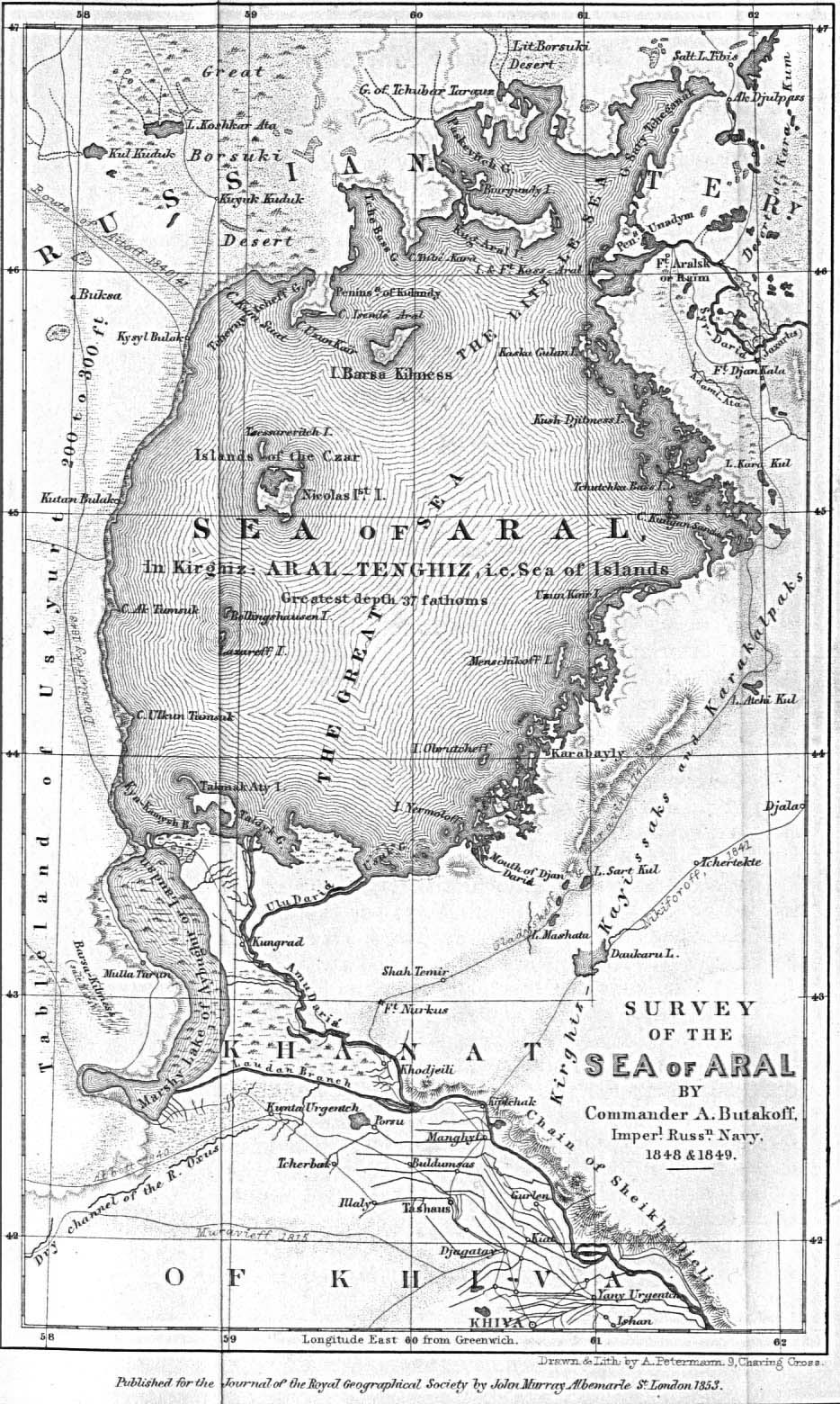
Butakov’s map of the Aral Sea (Translated and published in the Journal of the Royal Geographical Society in 1853) (Source: Perry-Castañeda Library Map Collection, University of Texas (http://lib.utexas.edu/maps/historical/aral_1853.jpg))
4 History of Research and Exploration to 1960
Even though a huge water body, the Aral Sea was relatively unknown in the ancient world. According to the famous Russian orientalist V.V. Bartold, writing early in the twentieth century, a reference to it as the “North Sea” or “Western Sea” exists in Chinese documents dating to 200 BC (Ashirbekov and Zonn 2003, p. 13). The Byzantine ambassador referred to a sea-lake in the region in 568 AD. Arab geographers are credited with the first reliable references to the Aral. Ibn Ruste in the tenth century AD. provided a description of the lake and stated the Amu Darya (then designated the Oxus) flowed into it, but didn’t name it (Ashirbekov and Zonn 2003, p. 19; Rubanov et al. 1987, p. 13).
Russian investigations of the Aral Sea region began in the early eighteenth century with the expedition of A. Bekovich-Cherkasskiy, sent by Peter-the Great in 1715–1716 (Bortnik and Chistyayeva 1990, p. 10). As Russian power and influence in Central Asia grew, more serious research began. In 1740–1741, one of the leaders of an expedition to the mouth of the Syr Darya, I. Muravin, utilizing instrumental surveys, composed a landscape map, which showed part of the Aral Sea, the Syr Darya Delta, and the Khiva Khanate. This is considered one of the oldest Russian maps of the area, showing cities that were later destroyed and also rivers whose beds shifted or that dried.
The nineteenth century saw much more extensive Russian research devoted to the Aral Sea and surrounding region. In the 1820s, E.A. Eversman studied the coastal zone of the Aral Sea, providing a description of its physical-geographical and geological character and advanced an opinion about the sea’s drying. E.K. Meyndorf in 1820 made the first geological description of the near Aral region (Aladin and Plotnikov 2009). In 1823 and 1825–1826, the expedition of Colonel F.F. Berg studied the western shore of the Aral and also completed a survey (leveling) of the Ustyurt Plateau.
Lieutenant A. I. Butakov (later to become Admiral) led the most famous nineteenth century expedition to the Aral in 1848–1849 (Aladin and Plotnikov 2009; Rubanov et al. 1987, p. 13; Bortnik and Chistyayeva 1990, p. 10). He was first to directly investigate the Aral Sea proper from the decks of the Schooner “Constantine”. Butakov measured depths, described the shoreline, investigated currents, surveyed the islands, sampled bottom sediments, gathered geological materials and natural samples, determined geographical coordinates, and conducted astronomical and meteorological observations. The famous Ukrainian poet T.G. Shevchenko accompanied Butakov on the expedition and composed an album of shore types as well as other drawings and watercolors of natural features, expedition life and local people (Rubanov et al. 1987, p. 13; Shevchenko 1954).
A key result of the expedition was publication of the first reliable marine chart of the Aral Sea by the Sea Ministry of the Russian Government. This and other information from the expedition allowed development of navigation and trade on the sea and the two influent rivers. However, only a short description of the expedition findings was published in 1853. The full expedition report would not appear for another century. The Aral map produced by the expedition was translated into English and published in the Journal of the Royal Geographical Society in 1853 (Fig. 2.8). The Butakov map shows the lake at a relatively high level, somewhat above 53 m, comparable to the level in the early 1960s. A more detailed map of the Aral Sea around 1850 attributed to M. Khanikov (Khanikoff) and drawn by the famous nineteenth century cartographer Augustus Petermann also shows the lake at a level a bit above 53 m.
The second half of the nineteenth century saw a flourishing of research on the Aral, leading to a marked increase of reliable scientific information about this lake (Aladin and Plotnikov 2009; Bortnik and Chistyayeva 1990, p. 10). In 1857, N.A. Severtsov and I.G. Bortshchov carried out physical-geographic observations on the northern and eastern coasts, including examining indicators of the sea’s desiccation. An expedition sponsored by the Imperial Russian Geographical Society and the St. Petersburg Society of Naturalists studied the sea in 1874 and gathered much new knowledge about its flora and fauna. A second expedition mounted by the Russian Geographical Society investigated the Amu Darya in the same year. One of its members was a geodesist (A.A. Tillo) who determined the exact level of the sea and placed a geodesic marker on the northwest coast of the sea, which was subsequently used as a reliable basis for measuring Aral levels. The first chemical analysis of the Aral’s water was published in 1870. In 1881, O. Grimm published a note about the history of the Aral based on its faunal composition.
Research on the Aral received a strong boost with the formation of the Turkestan Department of the Russian Geographical Society in Tashkent in 1897. This organization devoted considerable effort to the study of the Aral Sea. Its most illustrious Aral investigator was Lev Semyonivich Berg (Bortnik and Chistyayeva 1990, p. 10; Rubanov et al. 1987, pp. 14–15; Aladin and Plotnikov 2009). He led the expedition in 1899–1902 that conducted multifaceted geographic-hydrological investigations of the sea and surrounding region. Berg in 1904 installed the first sea level height gage near the present day city of Aralsk on the shore of the Gulf of Saryshaganak, which is part of the Small Aral Sea. He attempted to set-up an automated level recording device, but it worked irregularly providing only fragmentary records for several months of 1904 and 1905. Systematic instrumental observation of Aral levels began in 1911 at the hydrometeorological station named “Aral Sea,” first opened near Aralsk in 1884.
Berg returned to the Small Aral in 1906 where he gathered new geological and zoological collections. In 1908, he published a 530-page book titled, The Aral Sea: attempt at a physical-geographic monograph, which presented not only his findings but also those of earlier researchers (Berg 1908). In this work, Berg discussed many aspects of the sea’s hydrologic regime, including level fluctuations and water temperature, color, transparency and salinity. He also presented information on the connections between sea level and climate.
Berg asserted that there was no evidence that in historical times the Amu Darya flowed westward into the Sarykamysh Depression, and once it filled, through the Uzboy into the Caspian. A well-known contemporary, V.V. Bartold, who also worked in the Turkestan Department, based mainly on fifteenth century accounts that didn’t mention the Aral and in some cases even denied its existence, arrived at the conclusion that at this time the Aral Sea had completely dried (Bartold 1902). He also asserted that the Amu flowed westward into the Caspian during the fifteenth century and was the primary cause of the sea’s desiccation. We now know, as discussed in the previous section, that Berg was wrong and Bartold right on this, although the latter went too far in stating the sea dried completely during the late Middle Ages. Berg did support the idea of prehistoric connections between the two seas.
Research on the Aral continued until the outbreak of World War I in 1914. A new levelling survey by the Turkestan Dept. of the Russian Geographical Society established that a new rise in sea level was under way Bortnik and Chistyayeva 1990, p. 11. For the most part, scientific investigations came to a standstill from 1915 to 1920 during the war and ensuing civil war in Russia. With the consolidation of Soviet power, research resumed. In 1920–1921, a commercially oriented expedition studied the Aral in terms of its fishery potential. A scientific fishery management station was created for the sea in 1929. V.Ya. Nikitinskiy, A.L. Bening, and G.V. Nikolskiy led efforts investigating the Aral’s hydrochemistry, hydrobiology, and ichthyology. Their work was summarized in Fishes of the Aral Sea (Nikolskiy 1940).
Beginning in 1925, a network of hydrometerological stations was established around the Aral to supplement data collected at the first station set up near Aralsk in 1884 (Bortnik and Chistyayeva 1990, pp. 11–28). By 1960, this network consisted of 11 stations situated on the shore as well as on a number of islands (e.g., Barsakelmes, Vozrozdeniye, Uyali). These manned stations recorded data on water levels, salinity, and temperatures as well as wave and ice conditions. They also measured terrestrial meteorological parameters (air temperature, precipitation, humidity, barometric pressure, wind speed, and cloud cover) (Fig. 2.9)

Abandoned Hydrometeorological Station on the Eastern end of the former Barsekelmes Island in August 2005 (Photo by P. Micklin)
. Beginning in 1941, research vessels also conducted hydrologic observations in the open sea.
In the postwar years (1946–1960), the Aral scientific fisheries management stations, the Government Oceanographic Institute (GOIN) and other organizations conducted studies of the hydrometeorological, hydrochemical, and hydrobiological regimes of the sea in connection with the construction of the Kara-Kum Canal and the major expansion of irrigation in the basins of the Amu Darya and Syr Darya (Bortnik and Chistyayeva 1990, p. 11). These entities also investigated the water and salt balances, the biology of fish propagation, and carried out measures for the introduction of new species from other water bodies. Research was expanded on the deltas of the Syr Darya and Amu Darya focusing on the regularities of formation of the shoreline, soil, and the vegetation cover along with studies on how to improve fishery conditions. Blinov (1956) published a summary of hydrochemical work on the Aral. This author also provided a forecast of level changes accruing from reductions in river inflow from irrigation and from diversions to the Kara-Kum Canal, which was under construction at that time (Rubanov et al. 1987, p. 16).
Notes
- 1.
Micklin used the 1:500,000 Soviet bathymetric chart of the Aral published in 1981 and GPS coordinates for Kerdery #1 to determine the water depth. This chart uses 53 m for the long-term level of the lake, which gives an elevation for the site of near 35 m asl. The chart in the area of Kerdery shows bottom topography in 1-m increments. As the sea has shrunk, this chart has proven amazingly accurate. The CLIMAN group cites the level of the Kerdery grave as 32 m asl. They may have assumed the elevation was the same as the level of the Large Aral at the time (2002) because the site was adjacent to a large body of water. But the water seen was probably a shallow lake created by spring/summer outflow from the Small Aral and was at a higher level than the main part of the Eastern Large Aral.
References
Aladin NV, Plotnikov IG (2009) The Aral sea: yesterday, today, and tomorrow. Ecological Congress, St. Petersburg, Unpublished paper (in Russian)
Aladin N, Plotnikov I, Ballatore T, Micklin P (2008) Review of technical interventions to restore the Northern Aral Sea. In: Japan International Cooperation Agency: Study Reports: Country and Regional Study Reports: Central Asia and Caucasus, vol 4, pp 1–12. http://wldb.ilec.or.jp/ILBMTrainingMaterials/resources/Northern_Aral_Sea.pdf
Aladin NV et al (1996) Changes in the form and Biota of the Aral Sea over time. In: The Aral sea basin (proceedings of an advanced research workshop, May 2–5, 1994, Tashkent, Uzbekistan), NATO ASI series, vol 12. Springer, Heidelberg, pp 33–55
Ashirbekov UA, Zonn IS (2003) History of a disappearing sea. Executive Committee of the International Fund for Saving the Aral Sea, Dushanbe (in Russian). http://www.cawater-info.net/library/icc.htm
Atlas of the USSR (1983) GUGK, Moscow (in Russian)
Bartold VV (1902) Investigations about the Aral Sea and lower Amudar’ya from ancient times to the XVII century. Izv Turkest otd Russk geogr ob-va 4(2):120, Tashkent (in Russian)
Berg LS (1908) The Aral sea: attempt at a physical geography monograph. Izv Turkest otd Russk Geogr Obshchestva 5(9):580, St. Petersburg (in Russian)
Blinov LK (1956) Hydrochemistry of the Aral sea. Gidrometeoizdat, Leningrad (in Russian)
Boomer I, Wunnemann B, Mackay AW et al (2009) Advances in understanding the late Holocene history of the Aral sea region. Quat Int 194:79–90
Boroffka N, Oberhansli H, Sorrel P et al (2006) Archaeology and climate: settlement and lake-level changes at the Aral sea. Geoarchaeol Int J 21(7):721–734
Bortnik VN (1996) Changes in the water-level and hydrologic balance of the Aral Sea. In: Micklin P, William D (eds) The Aral sea basin (proceedings of an advanced research workshop, May 2–5, 1994, Tashkent, Uzbekistan), NATO ASI series, vol 12. Springer, Heidelberg, pp 25–32
Bortnik VN, Chistyaevaya SP (eds) (1990) Hydrometeorology and hydrochemistry of the seas of the USSR, vol. VII: Aral sea. USSR: Gidrometeoizdat, Leningrad (in Russian)
Cretaux JF, Letolle R, Calmant S (2009) Investigtions on Aral sea regressions from Mirabilite deposits and remote sensing. Aquat Geochem 15:277–291
Goode’s World Atlas (1982) Edited by Espenshade E Jr. Rand McNally and Company, Chicago
Kes AS (1978) Reasons for the level changes of the Aral during the Holocene. Izv Akad Nauk SSSR ser geog 4:8–16 (in Russian)
Khanikhov NV (1856) The Aral sea according to Khanikoff, by Petermann & GH Swanston. Published by A Fullarton & Co in Gazetteer of the world, London. Available from University of California, Berkeley, Library. http://www.lib.berkeley.edu/EART/maps/aral.html
Kosarev AN (1975) Hydrology of the Caspian and Aral seas. Moscow University, Moscow (in Russian)
Legostayev VM (1986) Is it necessary to combat water filtration from canals everywhere? Gidrotehnika i melioratsya 7:26–29 (in Russian)
Letolle R et al (2005) The future evolution of the Aral Sea from 2000 to the years 2050. Mitig Adapt Strat Glob Chang 10:51–70
Lunezheva MS, Kiyatkin AK, Polischuk V (1987) Central Asia and Kazakhstan – ancient regions of irrigation. Gidrotekhnika i melioratsiya 10:65–70 (in Russian)
Lunezheva MS, Kiyatkin AK, Polischuk V (1988) Central Asia and Kazakhstan – ancient regions of irrigation. Melioratsiya i vodnoye khozyaystvo 8:60–63 (in Russian)
Lvov VP (1959) Fluctuations of the Aral Sea level for the last hundred years. Trudy GOIN 46:80–114. (in Russian)
Lvovich MI (1971) Rivers of the USSR. Mysl, Moscow (in Russian)
Mayev EG, Mayeva SA, Karpychev YA (1991) The Aral Sea in the Holocene. In: Aral crisis. Academy of Sciences of the USSR, Moscow, pp 76–86
Mayeva SA, Mayev YeG (1991) Changes of the level of the Aral Sea for the recent millennia. Geodesia i aerofotosemka 1:124–132. Material from the interdepartmental seminar, “Issues of monitoring and means of resolving the ecological improvement of the Aral and Priaral’ya.” (in Russian)
Micklin P (1991) The water management crisis in Soviet Central Asia. The Carl Beck papers in Russian and East European Studies, No. 905. The Center for Russian and East European Studies, Pittsburgh
Micklin P (2000) Managing water in Central Asia. Central Asian and Caucasian prospects. The Royal Institute of International Affairs, London
Micklin P (2006) The Aral Sea and its future: an assessment in 2006. Eurasian Geogr Econ 47(5):546–567
Nikol’skiy GV (1940) Fishes of the Aral sea. MOIP, Moscow (in Russian)
Oberhänsli H, Boroffka N, Sorrel P, Krivonogov S (2007) Climate variability during the past 2,000 years and past economic and irrigation activities in the Aral Sea Basin. Irrig Drain Syst 21:167–183
Oreshkin DB (1990) Aral catastrophe, vol 2, Nauka o zemle. “Znanie”, Moscow (in Russian)
Rogov MM (1957) Hydrology of the Amu Darya delta; a geographic-hydrologic description. Gidrometeoizdat, Leningrad (in Russian)
Rubanov IV, Ishniyazov DP, Baskakova MA, Chistyakov PA (1987) “FAN”, Tashkent (in Russian)
Aral Sea (1981) Bathymetric map at scale of 1:500,000. Water Problems Institute, Moscow
Shevchenko T (1954) Diary. Izdatel’stvo. Khudozhestvennoy Literatury, Moscow (in Russian)
Tashkent Institute of Engineers of Irrigation and Agricultural Mechanization and The Aral Sea International Committee (1998) The Mirzaev Report, May 1998. This report, named for the principal author, was translated from an earlier Russian language report published in September 1996 under the title, which translates as ‘Conceptual Strategy for Proper Development of the Water Ecology Relations in the Aral Sea Basin’. It grew out of a seminar of independent Central Asian experts devoted to finding new approaches to alleviating water management problems in the Aral Sea Basin
World Almanac Books (2012) The World Almanac and Book of Facts 2012. World Almanac Books, New York
Uzbekistan Investment Guide (2012) http://www.investor.uz/?tag=cotton. Accessed 7 June 2012
Uzglavgidromet (1994–2003) Hydrologic data provided to P. Micklin by the main administration for hydrometeorology of Uzbekistan
Vinogradov AV, Mamedov ED (1991) The Aral Sea in the Holocene. In: Aral crisis. Academy of Sciences of the USSR, Moscow, pp 66–75 (in Russian)
World Bank (1998) Aral Sea Basin program (Kazakhstan, Kyrgyz Republic, Tajikistan, Turkmenistan, and Uzbekistan). Water and environmental management project. World Bank, Washington, DC, May 1998
Zenkevich LA (1963) Biology of the seas of the USSR. Academy of Sciences of the USSR, Moscow (in Russian)
Author information
Authors and Affiliations
Corresponding author
Editor information
Editors and Affiliations
Rights and permissions
Copyright information
© 2014 Springer-Verlag Berlin Heidelberg
About this chapter
Cite this chapter
Micklin, P. (2014). Introduction to the Aral Sea and Its Region. In: Micklin, P., Aladin, N., Plotnikov, I. (eds) The Aral Sea. Springer Earth System Sciences, vol 10178. Springer, Berlin, Heidelberg. https://doi.org/10.1007/978-3-642-02356-9_2
Download citation
DOI: https://doi.org/10.1007/978-3-642-02356-9_2
Published:
Publisher Name: Springer, Berlin, Heidelberg
Print ISBN: 978-3-642-02355-2
Online ISBN: 978-3-642-02356-9
eBook Packages: Earth and Environmental ScienceEarth and Environmental Science (R0)