
Abstract
This chapter studies the basic physiographical and oceanographical peculiarities of the Adriatic Sea. It describes in brief the islands, coasts, relief, and bottom sediments. It provides the general hydrometeorological characteristics (wind, waves, and precipitations). Special attention is focused on the hydrological regime of the sea (water masses, currents, temperature, and salinity). In addition, it dwells on the present-day development of the Adriatic Sea, i.e., tourism, fishery, mariculture, hydrocarbon production, and shipping.
Access provided by CONRICYT-eBooks. Download chapter PDF
Keywords
1 Introduction
As this book is devoted to the Boka Kotorska Bay, one of the largest and most interesting features of the Adriatic Sea, the editors agreed that this book should be opened with the chapter on the Adriatic Sea.
There are many publications on the research of the Adriatic Sea that began in the mid-sixteenth century and goes on till now. Taking into consideration that the Adriatic Sea is professionally studied by many institutes and laboratories of the coastal countries we thought it appropriate to give the general description of the Adriatic Sea having included there not only the oceanographic information, but also the historical and economic aspects.
The Adriatic Sea is a semi-closed water body occupying the northern part of the Mediterranean Central Basin. In the antiquity this sea was called Mare Superum (Lat.), and later on Mare (H) Adriaticum. The etymology of the name “Adriatic Sea” may be traced to the Etruscan settlement of Adria and the ancient port in the mouth of the Po River (from Illirian word “Adur” meaning “water” or “sea”). But the Greeks applied this name, according to Herodotus and Euripid, only to the northern, upper part of the sea and from the fourth century BC this name meant the whole Adriatic Sea in its present borders. One time it was called the Venetian Bay (Map of Cantelli, 1684). In the Greek–Roman period the name Mare Dalmatianum was used. In the Middle Ages the southern Slavs – Croatians, Bosnians, Serbs, Montenegrins, and Macedonians called it the Yadran Sea (“blue sea”) as they call it now [1].
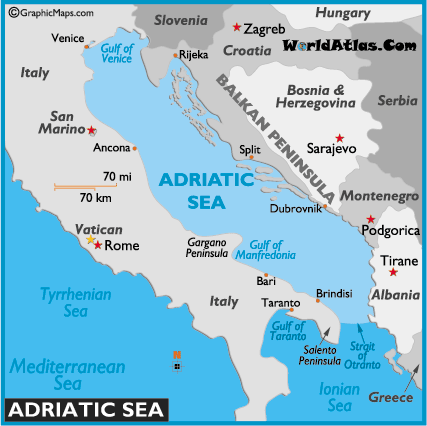
The Adriatic Sea is the largest arm of the Mediterranean Sea incising deep into its northern coast between two large peninsulas of Southern Europe – Apennine and Balkan (Fig. 1). The Strait of Otranto or the Otranto Gate or Adriatic Gate is located in the place where the distance between the Corfu Island (Greece) near the southwestern coast of the Balkan Peninsula and the Santa Maria di Leuca Cape (Italy) on the Apennine Peninsula is the minimum. This strait 72 km wide and 741 m deep connects the Adriatic Sea with the Ionian Sea. The International Hydrographic Organization defines the southern boundary of the Adriatic Sea as a line running from the Butrinto River’s mouth in Albania to the Karagol Cape in Corfu (Greece), through this island to the Kephali Cape and on to the Santa Maria di Leuca Cape.

The Adriatic Sea (http://www.worldatlas.com/aatlas/infopage/adracsea.gif)
The Adriatic Sea washes the coasts of six countries: Italy (1,249 km), Slovenia (47 km), Croatia (1,777 km), Bosnia and Herzegovina (23 km), Montenegro (298 km), and Albania (362 km). The western coast belongs to Italy, the eastern is shared by Slovenia, Croatia, Bosnia and Herzegovina, Montenegro, and Albania [1] (Fig. 1).
The Adriatic Sea extends from the southeast to the northwest for nearly 770–776 km; its width varies from 93 to 248 km. Its coastline is 3,707 km long and adding here islands it makes 6,200 km. The area of the sea ranges from 131,500 to 138,600 km2 accounting for 4.6% of the area of the Mediterranean Sea. The area of the continental shelf (from the shore to a depth of 200 m) is 102,415 km2 or 73.9% of the sea area [2]. The volume of the sea is around 35,000 km3.
The Adriatic Sea is seated in a long depression or synclinal fold (Fig. 2). Its present size and form appeared in the early Quaternary period as a result of transgression. In the late Tertiary period the Earth’s crust sagged and the depression was formed that later on was filled with sea water. That time the Otranto Sill was also formed. The analysis of tectonic processes observed on the sea shores led the scientists to a conclusion that for several million years the Apennine Peninsula had been drifting towards the Balkan Peninsula and the Adriatic Sea is slowly, but inevitably shrinks.

Bottom topography of the Adriatic Sea (http://oceanlab.cmcc.it/afs/img/AFS/2.png)
In the Adriatic Sea the largest are the Gulf of Venice, the Gulf of Trieste, the Gulf of Manfredonia, the Gulf of Quarnero, and Boka Kotorska Bay.
The Adriatic Sea contains from 1,233 to 1,300 islands, mostly, along the eastern shores. The Italians assert that this figure is bigger if add here the islands in the Po River Delta, small islets in the Venetian Lagoon. They include 79 large islands, 525 islets, and 642 outcrops of cliffs.
Out of 1,233 islands of the Adriatic Sea, cliffs, and reefs, 1,185 belong to Croatia. These are the Dalmatian Archipelago located between Dubrovnik and Istria Peninsula at a distance of 120 km from the shore. In some places they extend parallel to the shore (Fig. 3). The biggest coastal islands in Croatia are Cres (406 km2), Krk (406 km2), Hvar (299 km2), Pag (287 km2), and Korcula (276 km2), and the Brac Island (396 km2) whose elevation over the sea level reaches 780 m. By the coastline length the islands may be ranked as follows: Pag – 269.2 km, Hvar – 254.2 km, and Cres – 247.7 km. All big islands are covered with mountains and cliffs which height may be over 400–500 m. They are composed of limestones and karst formations. The most populated islands are Krk and Korcula. The islands along the Italian coast of the Adriatic Sea are mostly small and less numerous compared to the eastern coast.

Islands in Croatia (http://www.find-croatia.com/blog/wp-content/uploads/map-croatia-islands.gif)
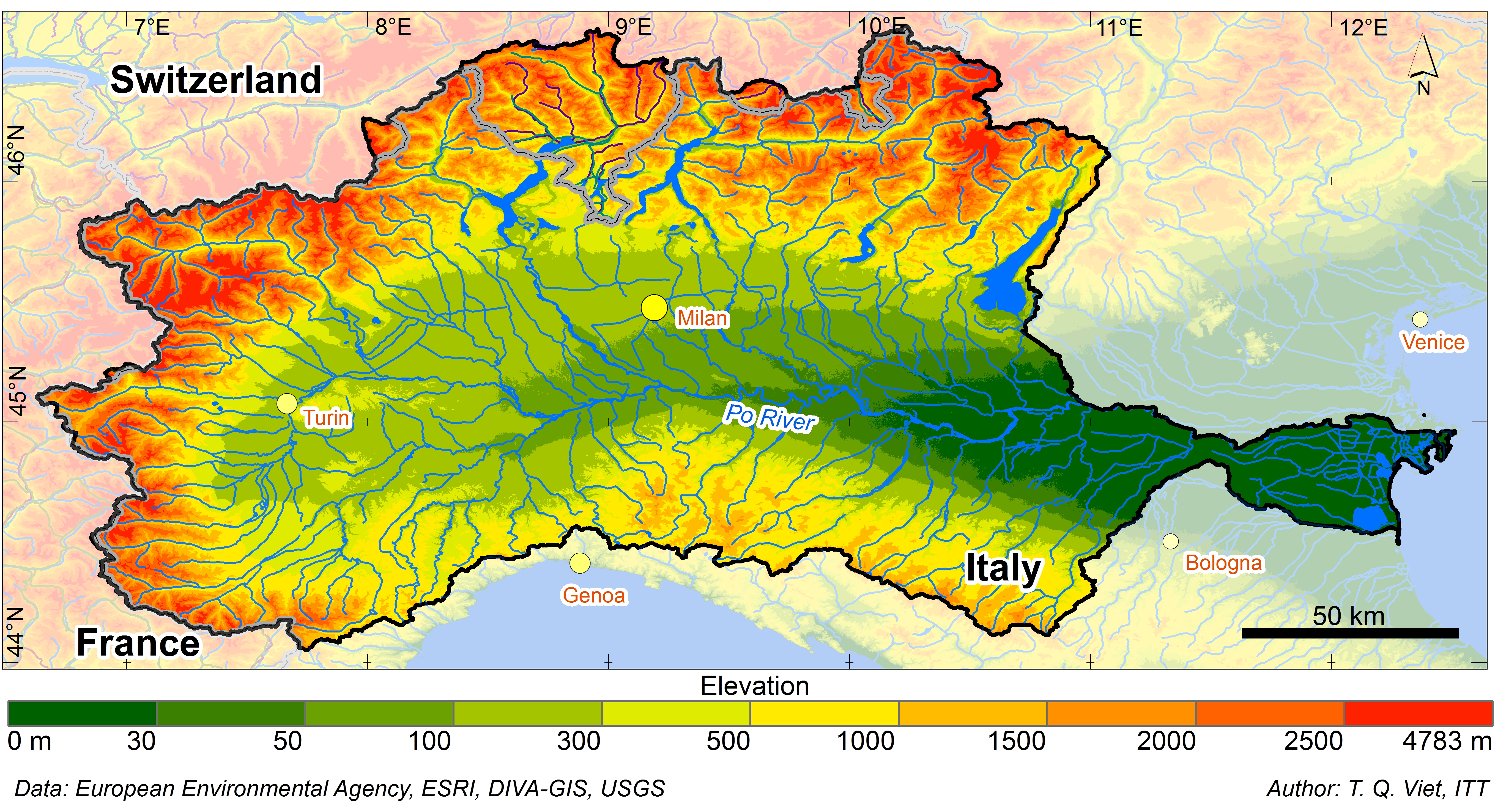
The watershed area of the Adriatic Sea is 235,000 km2. About 500 rivers bring their fresh waters into the Adriatic Sea. Among them there are big and many small ones. The main rivers discharging into the Adriatic include the Po, Soča, Isonzo, Krka, Neretva, Drin, Bojana, Vjosë, Seman, Shkumbin, Piave, Brenta, Pescara, and Cetina. Their total average annual flow is 5,700 m3/s, out of which around 28% or 1,585 m3/s is contributed by the Italy’s biggest Po River running in the northwestern corner of the shallow western part of the sea (Fig. 4) [3]. The second largest source of fresh water is more than 150 small rivers of Albania which total flow makes about 1,300 m3/s [2].

Po River Basin (http://www.basin-info.net/images/po/pobasin1.jpg)
The coldwater rocky coast of the Adriatic Sea is situated 2 km southward of Vlorë (Albania). There are found 34 karst springs with the total flow of about 900 l/s of very cold water going into the sea [2].
2 Coasts
The coasts of the Adriatic Sea are asymmetric: its northeastern and southwestern coasts differ greatly in appearance. The southwestern Italian coast in the eastern part of the Apennine Peninsula is represented, largely, by the straight, linear, low-lying, and continuous aggradation shores. Here many long, wide, sandy, and gravel beaches and lagoons can be found which cover about 160,000 ha. It should be noted here that prior to the Roman Times this area was as large as over three million ha. It shrank as a result of drainage works. The southwestern coast of the sea represents the rolling and, in places, terraced plain up to 10–18 km wide composed of the Pleocene and Plestocene marine deposits. The large barrier-and-lagoon complex is formed with wide lagoons and narrow sandy bars covered with dunas which are overgrown with sparse shrub vegetation. Only in some small areas the low-lying scouring benches developed in loose marine and alluvial-marine deposits with narrow beaches are observed. The cliffs in the parent rocks are most typical of the eastern coast of the Gargano Peninsula, the Le-Mourdji Plateau, and further on southwards. Generally, the aggradational coasts prevail to the north of the Gargano Peninsula and the abrasion coasts to the south of it [2].
The Adriatic’s northernmost part contacts on the Venetian Lagoon crossed by numerous rivers. The northwestern part of the sea is quickly filled with sediments brought by rivers, mostly Po and Adige, which contribute annually up to 20 million tons of sediments consisting for 7% of clay, 70% of silt, and 23% of sand. This has led to changes in the coastline and active protrusion of the multi-arm delta into the sea (by 40 m per year on the average). As a result, the ancient ports in these deltas with very convenient harbors for ships, such as Acquila and Adria which history could be traced to the Roman Times, are now distanced for over 22 km from the sea. The marine and alongshore wave currents drifting here catch up some fine sediments of these rivers and move them to the south.
Farther from the coastline the terrain becomes gradually more elevated and acquires the hillocky relief. From time to time in some areas the low mountains composed mostly of dolomite, marble, red and white limestone, and dark sandstone are met. They are usually overgrown with thick shrub vegetation, oak and olive groves. The monotony of this coast is broken only by high and abrupt Gargano Peninsula protruding far into the sea and forming on its southern side the Manfredonia Bay opening widely towards the sea. The northern side of Gargano forms the flat Tremiti Harbor closed by two groups of small islets – Tremiti and Pianosa (Italy).
The northeastern coast of the Adriatic makes up the western part of the Balkan Peninsula. It is mostly upland. By the ratio of tectonic structures it is referred to the well-pronounced longitudinal type. The high Dinarian Upland extends almost along the whole coastline of the sea. Its maritime part (elevations up to 2,500 m) is composed of the Mezosoic limestones and partially flysch. The rocks form large anticlinal folds running parallel to the coastline, while the domes are often broken by denudation processes. As a result of joint action of the Holocene transgression and tectonic subsidence of the coast the sea intruded into the geosynclinal depressions and denudation lowerings in the domes of positive structures and formed numerous long and narrow bays extending along the abrupt coast of the sea. This is considered the world’s most incised coast with its great number of harbors, bays, peninsulas and 1,185 islands, and islets, differently shaped rock outcrops forming the most fanciful configurations and having small stony and pebble beaches. It is cut by some gulfs and bays the biggest of which are the Kvarner Gulf and the Gulf of Trieste separated from each other by the elevated Istria Peninsula. Nearby the coast there are numerous large and small islands oriented lengthwise repeating the respective series of positive tectonic folding. The “internal” coast is well protected from the wave effect by the barrier of islands. It was not practically subject to the sea action and kept the vivid traces of its initial dissection (tectonic and denudation) [4].
Moving to the northwest (the Istria Peninsula) and to the southeast (Montenegro coast) the typical features of the Dalmatian type of the coast become less pronounced. The archipelago of elongated islands practically disappears, giving place to the abrasion areas that become dominating in the picture of the mountainous coast.
Along them the benches are usually worked out and the clear-cut terrace step at a depth of 8–10 m may be traced along the whole Adriatic coast marking, perhaps, the ancient sea level.
In the coastal areas where the shore cliffs are composed of the Mezosoic and Tertiary limestones the coastal and underwater karst forms associated with the leaching effect of sea water on limestones are widely developed. In Dalmatia karst formations occur to a depth of some 10–15 m. Multiple protrusions, hollows, funnels, deep troughs, and ridges in limestones in the inshore zone are formed.
Apart from karst processes, the bioerosion also contributes to destruction of the limestone coastal benches which is caused by vital activities of microorganisms and sea urchins eating microflora of animals. The former corrode the rock surface, while the latter scrape off the rock particles in search of feed. The products of limestone destruction accounting for 10–13% dissolve in water and the remaining 70–90% has the texture from silt to fine sand. The distribution of organisms in the coastal belt features certain zonality determined by physical, chemical, and biological factors. This zonality results in different rates of bioerosion in different littoral areas (0.1–1.1 mm/year) and in development of the biogenous erosion niche in the cliff basement at the tide level. Generally, about 11 kg of limestone is annually removed from 1 linear meter of the shore, out of which about 9 kg consists of fine materials making 3–25% of the coastal sediments. Changes in the organism distribution influence significantly the rate of erosion and sediment accumation. Thus, in the 1970s the active propagation of sea urchins was observed in this area as a result the rate of coastal limestone destruction had nearly doubled.
One of the specific geographical features here is the Dalmatian type of the sea coast that has been called so by the name of the southern part of Croatian Adriatic – Dalmacia taking its origin in the Antique Roman Province of Dalmatia. Such type of coasts with initial structural fundamental dissection is characterized by parallel running of coastlines of the greater part of islands to the main direction of the coastal (mainland) relief (Fig. 5). The coast of Albania is quite different. Between the Vlera Gulf and the mouth of the Drin there is the Albanian Lowland 15–18 km wide. Its coastal area abounds in river deltas, lagoons, wetlands, and dunes. Moving farther into the coast the terrain becomes gradually more elevated and hillocky. In the north and south of the Albanian coast the limestone ridges 300–400 m high come close to the shore at some angle creating a series of elevated capes [4].

Dalmatian type of the coasts (http://www.butterfield.com/blog/wp-content/uploads/2013/06/croatia-blog-banner.jpg)
The low-lying areas and piedmonts of mountains to a level of 200–400 m are overgrown with evergreen shrubs, oaks, and pines. The olive trees, orange and lemon groves, and vineyards prevail above this belt. The islands of the Dalmatian Archipelago are the tops of coastal ridges of the Dinaric Plateau.
The researches have shown that the bottom of the Adriatic Sea in this area is dropping down significantly.
To the northeast of Triest the changes in the coast structure become visible – it becomes irregular, steep, and abrupt. The Istria Peninsula wedges into the sea for 90 km. The Croatian coast and its harbors are more elevated and abrupt than the Istria shores.
The shores of the Adriatic Sea locate in the seismically active zone. The earthquakes with magnitude 6–9 occur near the coasts of Italy, Albania, Montenegro, and Croatia.
3 Bottom Relief and Sediments
The bottom of the Adriatic Sea represents a depression sloping smoothly from the northwest to the southeast (Fig. 2). The seabed relief was formed by tectonic displacements that had occurred several million years ago. In some parts the seabed is leveled out by sediments and the rivers flowing into the sea make the seabed silty.
By the physiographical conditions, bathymetry and bottom relief there are distinguished the Northern, Central, and South Adriatic Basins. The northern basin of the sea is not deep; it is bordered by the Karlobag (Croatia) – Ancona (Italy) line. The depths in the northern basin reach maximum of 70 m. The central basin is confined by the Ploce (Croatia) – Gargano Peninsula (Italy) line. Here the depths reach their maximum of 273 m in the Middle Adriatic Pit (MAP) or else called Jabuka/Pomo Pit. In general, the depths here are to 200 m. The 170 m deep Palagruža Sill is south of the MAP, separating it from the 1,230 m deep ovally shaped South Adriatic Pit or Bari Pit which makes it the deepest part of the Adriatic. Further on to the south, the sea floor rises to 780 m to form the Otranto Sill.
The depths of the Adriatic Sea near coasts are closely connected with the coastline physiography. In places where shores are high and mountains come out here the sea depth nearby such places is great. This is observed near the Istrian and Dalmatian coasts of Slovenia and Croatia. The seabed relief along the Albanian coast is rather flat; the depths are smoothly growing seaward. The isobath of 100 m passes 9–10 km from the coast, while the depths of 800–1,000 m occur 50 km from it. The Croatian coast is rather steep; while moving to the northwest the seabed relief becomes more rugged. The off-sea edges of islands are very steep; in many places the isobath of 100 m passes at 2–4 km from them. Very rugged bottom relief is observed in passages among islands abounding in bars, shoals, and cliffs.
The bottom sediments in the Adriatic Sea are represented by recent sediments of various mineralogical and granulation composition. Silty and sandy deposits cover the greater part of the continental shelf. Such type of deposits prevails in the South and Central Adriatic as well as in the coastal areas in the northeast of the sea, in the Trieste Gulf and a narrow strip along the northeastern coast of Italy. The bottom of the sea is made mostly of silt, fine sand containing many shell residues. Near the abrupt shores the coarser sand appears that overlays the marble basement. Its distribution in the sea is dependent on the sea floor relief and water dynamics. Marine currents determine their longitudinal dispersion. The North and Middle Adriatic accept over 80% of the liquid flow and over 60% of the solid flow. The enrichment with the terrigenous material occurs in the near-mouth areas from where it is spread with currents. The terrigenous material gets into the sea as a result of abrasion and is also brought with the winds [5].
Not long ago the American specialists have found the fault of lithospheric plates about 200 km long under the Adriatic Sea. It takes its origin not far from Dubrovnic. On the basis of the GPS data the scientists concluded that this fault was associated with the formation of the Dinaric Alps – a mountain chain on the Adriatic coast 645 km long and the Dalmatian islands. This fault also influences the position of the Italian “boot” which “heel” moves closer to the Croatian coast by 4.5 mm every year, while the Adriatic floor “slides” under the Balkans. The scientists estimated that approximately in 50–70 million years the Adriatic Sea will disappear from the map of Europe (http://wiki.ru/sites/okeanologiya/id-news-137968.html). It cannot be also excluded that this fault may be connected with the earthquakes that regularly occur in this region. However, so far we have no accurate data in this respect.
4 Climate
The Adriatic Sea extending meridionally between about 40° and 45°45′N belongs to the subtropical climatic zone, while its northernmost part is characterized by moderate climate. The climate here has some Mediterranean features, but, generally, differs significantly from the climate of the Mediterranean Sea. It is determined by the cyclonic and anticyclonic activity over the middle and southern Europe. Cyclones usually travel from west to east over the Adriatic Sea. In summer the spur of the Azores Anticyclone influences greatly the formation of the Adriatic climate. It creates the steadily dry and warm summer with cloudless sky. In winter the cyclonic activity determines the soft, humid, and cloudy winter with accidental sunny periods. Winter normally lasts from December through February. The coldest month is January. The average air temperature in this month is 6–9°C in the northern regions and 10–12°C in the southern regions. Spring is not long (March–April) and its average monthly temperatures are 13–14°C nearly everywhere. In spring the air temperature may rise to 29°C and drop below zero. Summer is the longest season lasting from late April through September. The hottest month is July with the average monthly air temperatures varying from 27°C in the north to 30°C in the south. The maximum air temperature in some coastal areas may be as high as 42°C that was recorded in August. Autumn starts in October when the air temperature drops to 14°C in the north and to 18°C in the south [6].
The cloudiness over the Adriatic coast features the clear-cut annual dynamics: it tends to increase in winter and to decrease in summer. The average monthly cloudiness is 5–6 points. The greatest cloudiness is observed in the northern part of the sea where its average monthly values vary from 6–7 points in winter to 3–5 points in summer. In spring and autumn the cloudiness is not more than 6 points. In the other parts of the sea the average monthly values of cloudiness fluctuate from 4–5 points in winter to 1–3 points in July and August. The average number of cloudless days in a year varies from 120–130 in the south to 100–110 in the north [6].
The average annual precipitations here are around 1,000 mm. The amount of precipitations over the sea decreases from the northwest to the southeast. On the coast the greatest precipitations fall in the northernmost areas (Trieste, Rijeka); their annual amount averages 1,075–1,555 mm. Precipitations are usually represented by rainfalls and rainstorms. The precipitations are distributed within a year very unevenly; the greater part of their annual amount falls in autumn and winter seasons. In these months the average precipitations vary from 60–90 mm on the southwestern coast to 150–200 mm on the northeastern coast. The minimum precipitations are usually recorded in July – not more than 30–45 mm. The precipitations are especially meager in July in the southern part of the sea where their monthly amount makes 13–15 mm. The exception is the northern coast of the sea where the minimum precipitations fall in January–February making 40–60 mm [6].
The average annual number of days with advective sea fogs in many regions of the sea fluctuates from 1 to 10, except the Venetian Plain with its multiple lagoons and the mouth of the Po River which contribute to formation of fogs that are most dense here and may last as long as 30 days. Fogs mostly occur in October through April. In the north of the sea they are observed more frequently that in the middle and southern parts [6].
Such phenomenon as haze is often observed over the Adriatic Sea. It is formed by dust and fine sand brought here with the southern winds blowing from Northern Africa.
Snowfalls are quite rare here and occur only in the northwestern part of the sea. The average annual number of days with snowfalls is 4–6 in the north of the sea and 1–2 in the south of the sea. The snow forms a cover only for a very short time.
Among specific meteorological events observed here there are thunderstorms and snowstorms. Thunderstorms may occur in any season of a year, but they happen here more frequently than anywhere else in Europe. They are most frequent in July, August, and September. In the north they occur to 9 days in a month, on the average, while on the Dalmatian coast only 4 days per month. Thunderstorms are usually accompanied by strong gusts of wind. Here the windforce may be as high as 6–8 points, while during “Garbina” winds – even 11 points. Many thunderstorms observed over the Adriatic cross the sea as thunder squalls from southwest to northwest. Their velocities are about 25–35 km/h. Snowstorms occur very seldom and only in winter in the northern part of the sea [6].
5 Wind and Waves
The wind regime of the Adriatic Sea is determined by the effect of such factors as regional atmospheric activity, coast relief (orography), and local circulation provoked by temperature differences of land and sea. The most typical local winds for the Adriatic are Sirocco, Mistral, Bora, Gabrina, and Tramontane.
During a year the winds blowing from the north and northeast are prevailing over the Adriatic. Their recurrence in some months is as high as 60%. The exclusion is the southwestern coast where the northwestern winds are dominating.
Sirocco is the warm southern dry tropical wind from the deserts of the Arabian Peninsula and North Africa. It blows from the southwest bringing with it the dreary weather, clouds, and storms. Sometimes, mostly in winter, it can reach the hurricane magnitude. The maximum windforce of Sirocco may reach 7 points; it usually lasts for 2–3 days in succession. In the period from October through May it blows more frequently and with greater force (to 9 points). It may be also followed by a storm with the waves 3–4 m high. The signs of coming Sirocco are rough, surging sea, while in the Central and North Adriatic – tides. After long southern winds the water level in ports may rise.
Mistral is blowing mostly from the northwest in the period from June to mid-September when the low-pressure area gets established over the Balkan Peninsula. It usually starts blowing about 10 h in the morning and reaches its force of 3–5 points by the midday and calms down by the sunset. Mistral is considered to herald good weather – it brings clear blue sky. In the recent years it has been noted that Mistral has occurred more seldom. Nevertheless, it still blows quite frequently, particularly, on the coasts of remote islands.
Bora is typical of the eastern Adriatic coast. This is a cold northeastern wind blowing with sharp and very strong gushes through the passages in the Dinaric Alps on the Adriatic Sea and, at the same time, is one of the causes of extreme and dangerous situations in the coastal area. When strong wind is blowing, especially from the snow-covered mountains, the buildings and ships are quickly coated with an ice crust. This wind may overturn cars and boats. The Bora speed may reach 40 m/s and its may last from several days to several weeks. One more cause of Bora is the sharp differences of temperature and atmospheric pressure between mainland and islands in the Adriatic. The greater is the pressure difference, the stronger are the wind gushes [7].
The strongest Bora gushes are usually recorded in the territory from the Cres Island to the Mljet Island on the western coast of Dalmatia. Bora may also occur at any time of the year, but it still blows most often in winter. On the Velebit Canal, in Split, near the Vrula Bay (north of Makarska) and on the Peleshac Peninsula the Bora gushes even in summertime may reach the force of 8–9 points. In the period from November through April the Velebit Canal becomes one of the most dangerous places in the world.
In summer Bora is usually blowing 2–3 days in succession. Bora of medium intensity may be even positive – it cools the air and makes it clearer. In winter in the North and Central Adriatic Bora may blow for several weeks in succession with only short intervals.
Storms are mostly observed in the areas of Bora action, i.e., on the northeastern and northern coast of the sea. They are most frequent in the period from November through March. The average monthly number of days with storms in this period varies from 2–3 in Dubrovnik to 4–9 in the Port of Trieste. On the southwestern coast of the sea the number of days with storms in this period does not usually exceed one per month and only in the Port of Ankona it is three. In summer the storms are usually not long and occur as individual gusts [7].
The short southwestern storm wind Gabrina usually lasts from 1 to 2 h in summer. It instantly reaches the force of 8–11 points. This wind always brings hurricanes and thunderstorms. It is formed when in the south of the Mediterranean the high pressure area gets established and simultaneously the Adriatic center of low pressure moving eastwards appears in Central Europe or in the north of Italy.
The Adriatic Sea is usually calm because more than 75% of the total number of waves is less than 0.5 m high. Moderate sea prevails most of the year (from 0 to 2 points). Resulting from the prevailing wind belt over the Adriatic the waves in open sea are most frequently rolling from north to south. The waves generated by long Jugo, Jugo-Sirocco (southeastern) winds are higher than waves from Bora. The greatest waves 10.8 m high were recorded in the north of the Adriatic Sea. Near the Palagruža Island the maximum wave height of 8.4 m during Sirocco and 6.2 m during northeastern Bora was observed. However, it will be improper to think that the waves from the south are more dangerous than from the northeast. Quite the opposite – the period of waves generated by the northeastern winds is twice as shorter than southern winds: 50 m compared to 100 m and more, and their amplitude is very irregular. The waves from summer Tramontane (daytime northwestern wind) reach their maximum height of 4 m in the South Adriatic.
6 Hydrology
The hydrological regime (thermohaline properties) of the Adriatic Sea is determined to a great extent by water exchange with the Mediterranean via the Strait of Otranto, river runoff, currents, and climatic conditions. The hydrological regime is also influenced by the sea elongation in the northwestern direction, sharp difference of depths in its northwestern and southeastern parts, and coast irregularity.
The hydrological regime is characterized by high water temperature, high salinity, insignificant water level fluctuations, weak currents, and low recurrence of high waves.
The Adriatic is a rather warm sea with the clear-cut annual variations of the surface water temperatures (Fig. 6) that tend to increase mostly from north to south and from west to east. The seasonal temperature fluctuations exceed +10°C due to atmospheric heat transfer. The shallower northern part of the sea is filled with the Adriatic surface water resulted from mixing the waters of the Ionian Sea with the coastal flow. In summer the temperature of this water mass is 22–24°C [6].

Climatological maps of SST in the Adriatic Sea in: (1) winter, (2) spring, (3) summer, and (4) autumn (https://www.researchgate.net/figure/266886126_fig5_Figure-5-Climatological-map-of-surface-temperature-C-in-winter)
In winter when the active cooling and development of convenction processes are observed the surface waters mix with the transformed Levantine waters and formed Adriatic bottom water masses getting into the sea. The bottom water fills pits in the Adriatic Sea and is distinguished by uniform features: its temperature ranges from 13.5 to 13.8°C. The lowest temperature is observed from December to February. In this period the average monthly temperature varies from 14 to 7°C nearby the Po River Mouth. Considerable difference of water temperatures is observed between the southwestern and northeastern shores of the sea: near the northeastern shore the water is by 2–3°C warmer, on the average, than near the southwestern shore. In March–April the surface water temperature over the whole sea rises and in May it reaches approximately 17–18°C [5].
In summer when thermocline is at a depth of 30 m in the North Adriatic and 50 m in the Central Adriatic the surface layer is clearly separated from the lower-lying water. The surface water temperature is similar across the whole basin and is equal to 23–24°C in the open sea. In this period the reverse temperature distribution compared to winter is observed. The average monthly water temperature increases westwards from 22°C near the Croatian shoreline to 26°C near the Italian coast. In September the surface water temperature drops and in October–November it makes mostly 16–17°C and only in the southwestern part of the sea it increases to 18°C and in the northwestern part it decreases to 13°C. The average annual water temperature in the sea does not drop below 11°C. The maximum temperatures are recorded in July and August and the minimum in February. The lowest surface water temperature in the sea in winter is around 7°C and quite seldom it may drop still lower. In spring the temperature rises and reaches about 18°C, while in summer it is as high as 22–25°C and in the South Adriatic even 27°C. The lowest sea water temperatures are in river mouths or in bottom freshwater sources.
Salinity of the Adriatic water is rather high, even higher than the world average values – around 38.3–38.9‰, which is less than water salinity (39‰) in the eastern part of the Mediterranean and higher than in its western part (37‰) (Fig. 7). The highest salinity in this area results from the inflow of saline waters from the Levantine Basin through the Strait of Otranto with its peak of 39.1%. In general, the water salinity decreases from south to north and from the open sea towards the shores. The salt balance of surface waters is subject to the river runoff. In the North Adriatic due to river flow the water salinity tends to decrease and varies here from 25–30‰ nearby the Po River Mouth and to 37‰ in the Kvarner Gulf. The fresher coastal waters most noticeable along the western coast are always separated and differ from open sea waters and are marked by the presence of the salinity front [8].

Climatological maps of sea surface salinity in the Adriatic Sea in: (1) winter, (2) spring, (3) summer, and (4) autumn (https://www.researchgate.net/figure/266886126_fig6_Figure-5-Continued-Climatological-map-of-surface-salinity-in-winter-5-spring-6)
The greatest water density on the sea surface is observed in October through March and varies from 1.026 to 1.030. In the period from April through September it decreases to 1.025 and in the most northwestern part of the sea to 1.022. The waters of the Adriatic Sea are very clear; it is one of the highest in the world; their clarity may reach 56 m.
The level fluctuations in the Adriatic Sea are not great and caused mainly by tidal and surge events. Mostly abnormal semi-diurnal tides (up to 1.2 m) prevail here. The abnormal semi-diurnal tides are less distributed and only near the Dugi-Otok Island the normal diurnal tides are observed. The tides are not high. The average height of the tide varies from 0.2–0.4 m in the south of the sea to 0.7–0.8 m in the north. In the most northwestern part of the sea and near the Gulf of Trieste the tide height may be as large as 1 m [7].
The greater water level fluctuations are caused by winds. When the north-east and south-west winds blow in the harbors in the North Adriatic the water level rises to 0.9 m and in the Port of Venice to 1.8 m. The northern winds may cause such recession of water that the sea floor of lagoons becomes exposed [6].
During Bora the water level drops by 0.4 m on the average. The seasonal variations of the water level in the Adriatic Sea are insignificant. The highest average monthly levels are usually recorded in November and December, while the lowest in January through March.
The seish-like fluctuations of the sea level are also observed; in some places they may be as high as 0.8 m [6].
7 Currents
The permanent tidal and wind currents are observed in the Adriatic Sea. They move at great speeds. Permanent currents represent a whirl directed counterclock-wise being, probably, a continuation of the general water circulation in the Ionian Sea. Waters from the Ionian Sea got into the Adriatic Sea via the eastern part of the Gulf of Otranto and generate the northwestern coastal current (Fig. 8). The backflow is created by cold waters of the North Adriatic (NAdDW) that are formed in winter and move to the south at great depth along the Italian shores. Some of these waters replenish deep waters (MAdDW) near the Pomo Pit in the central part of the Adriatic Sea [5]. The water exchange through the Gulf of Otranto features seasonal differences. In the winter at depths more than 300 m the waters move from the Adriatic Sea; in the horizon 700 m deep the velocities of 20–30 cm/s are recorded. In the summer in the deeper layers of the strait the water current from the Ionian Sea moves to the north with the speed of 5–10 cm/s. However, in the summer the south-directed current may also be observed near seafloor above the sill [9].

General currents in the Adriatic Sea. EAC Eastern Adriatic Current, WAC Western Adriatic Current, NAdG North Adriatic Gyre, MAdG Middle Adriatic Gyre, SAdG South Adriatic Gyre (https://www.researchgate.net/figure/266886126_fig1_Figure-1-Adriatic-Sea-bathymetry-morphology-and-main-surface-circulation-redrawn-with)
The general circulation consists of coastal currents and gyres that vary in space in different seasons. The Eastern Adriatic Current (EAC) goes along the eastern coast of the sea from the south to the north, forming three gyres – South Adriatic Gyre, Middle Adriatic Gyre, and North Adriatic Gyre (Fig. 8) [5]. In the circulation in the North Adriatic dominates the North Adriatic Current (NAdC) that turns waters to the south. In the winter (NAdC) is limited by northernmost part of the basin, while in the spring and summer it extends to the south. The Western Adriatic Current (WAC) goes along the Italian coast from north to south. In the central part of the Adriatic Sea it is known as Western-Middle Adriatic Current (W-MAdC). In autumn NAdC and W-MAdC joint to form the single current that may be traced in the southern part of the Adriatic Basin. Cyclonic Middle Adriatic Gyre (MAdG) is present in the central part of the Adriatic Sea in all seasons, except winter [5]. This current moves along the northeastern coast as far as the Mlet and Lastovo islands which deflect it somewhat to the west and further on it goes more seaward of the islands stretching along the Dalmatian coast and partially among them as far as the Istria Peninsula. From the northwestern coastal current near the Mlet and Lastovo islands the branch of the current deviates to the Palagruža islands and the Testa-del-Gargano Cape. Near the southernmost tip of the Istria Peninsula the current turns to the southwest. Sometimes it is found further to the north near the western shores of the Istria Peninsula [5].
However, in the northernmost part of the Adriatic Sea, to the north of the line Port Ancona – Dugi Otok Island, the system of currents is very complicated and variable. Here numerous gyres associated with the above-mentioned coastal northwestern current, river runoff, configuration of shores, and other factors are observed. It should also be mentioned that the river runoff produces essential influence on currents only after heavy rainfalls and locally. Turning to the southwest near the Istria Peninsula or going round the northernmost part of the sea, the coastal current passes further along the Italian coasts directed generally to the southeast. In the sea top the water gyres are observed rotating in the clockwise direction, thus, near the shore the current may be directed reversely compared to the current in the open sea [5].
At approaches to the Otranto Strait the branch is formed from the southeastern coastal WAC that goes eastwards joining the northwestern coastal current EAC and closing the water cycle in the Adriatic Sea. However, the main part of the southeastern coastal WAC continues its southern movement and gets into the Ionic Sea. The speed of the permanent coastal current is variable and makes, on the average, 0.3–0.5 knots. It depends, to a great extent, on the wind and the season of a year [5].
8 Flora and Fauna
The flora and fauna of the Adriatic Sea is rather diverse – over 7,000 species. More than 750 varieties of algae are growing here that may be divided into three groups: red, brown, and green. Four of the five kinds of algae inhabiting the Mediterranean are met in the North Adriatic along the Slovenian shores and the western coast of the Istria Peninsula in Croatia. Cymodocea nodosa and Zostera noltii are widespread, but Zostera marina and Posidonia oceanica are met quite seldom. The coastal area abounds in gastropods and bivalve mollusks having thick and strong shells protecting them reliably from wave impacts as well as Echinoderm and Crustacea. Currents bring here many soft and transparent jellyfish as well as night-fluorescent hydropolyps. In shallow areas there are many oysters, mussels, sea urchins, starfish, sea cucumbers (Holothuria), and small crabs; sea horses inhabit the thick algae growths. At greater depths there are found large Crustacea – lobster, large crabs, crawfish, as well as octopus, cuttlefish, starfish; at times eels and morays may appear here. The water mass abounds in plankton and fish fries. Of commercial fish you can find here sardine, scomber, mackerel, bonito, gray mullet, tuna, sea bream, common sea bream, sea bass, flatfish, lancet fish, and swordfish. The fishing of medium-sized shrimps is widespread here. The Adriatic Sea numbers 407 species and subspecies of fish representing 117 families; the Osteichthyes group includes 353 species and subspecies and the Selachii или Chondrichthyes group 54 species, which accounts for 72% of the known species and subspecies of fish in the Mediterranean (about 581 species and subspecies) [10–12]. In the recent decades the new fish species have been described in the Adriatic Sea which increased their number to 453 representing 120 families [13]. These are largely thermocyclic species which is perhaps connected with warming of the Mediterranean waters. Among sharks the pygmy sharks, piked dogfish, blue sharks, and fox sharks are common here, while the giant sharks are met very seldom. Among the mammals the dolphins and monk-seals referred to the threatened species live in the Adriatic Sea.
9 Sea Resource Management
The Adriatic’s shores are populated by more than 3.5 million people; the largest cities are Bari, Venice, Trieste, Ravenna, and Rimini (Italy); Split, Rijeka, Zadar, Umag, Poreč, Rovinj, Pula, Opatija, Sibenik, Trogir, Dubrovnik, and Ploče (Croatia); Durres, Vlora, Lege, Fier, and Shkoder (Albania); Koper, Isola, and Piran (Slovenia); Budva, Bar, Herceg-Novi, Kotor, Tivat, and Ulcinj (Montenegro); and Neum (Bosnia and Herzegovina).
The shortest sea and air routes between the Apennine and Balkan peninsulas cross the Adriatic Sea. Railroads and automobile roads running to Central and Eastern Europe originate in northern ports on the Adriatic Sea.
In all times the favorable geographic position and good climate facilitated development of the cargo and passenger national and international shipping. There are nineteen Adriatic Sea ports playing important role in economics of littoral states. Each port handles more than a million tons of cargo per year. The largest cargo ports are Rijeka, Split, Pula, and Dubrovnik (Croatia); Bar, Kotor (Montenegro); Koper (Slovenia); Durres, Vlora (Albania); and Trieste, Venice, Bari, Ancona, and Brindisi (Italy). The greater part of these ports is found on the eastern coast of the sea. The largest cargo seaport in the Adriatic is Trieste, while the largest passenger seaport is Split. There are also numerous small ports being very important for local coastal shipping (Sibenik, Zadar, and others). The Adriatic is the sea for yachtsmen. Traveling on cruise and sport boats, yachting have become very popular here, which required extension of the existing and construction of new marinas as well as private quays and piers. Nautic complexes are widely constructed here. A number of naval bases may be also found on the coast.
Oil and gas are produced in the Adriatic shelf. About 100 platforms locate near the Emilia-Romagna area. Some areas of the Adriatic are used for construction of the liquefided natural gas terminals. The first such terminal was built in 2009 in the North Adriatic near Porto Levante (Rovigo Province, Venice, Italy). The construction of new terminals in the Gulf of Trieste (Alpi Adriatico Terminal) in the Italian territorial waters near Slovenia is planned. Availability of such terminals spurs competition with other marine activities in the Adriatic Sea. Thus, fishery is prohibited around terminals and pipelines connecting terminals with the coast.
ENI (Italy) and INA (Croatia) established a joint venture that started producing gas by platform Annamaria A in 6 wells in the Croatian waters in 2009. In the Italian waters platform Annamaria B started producing in 2010 (Fig. 9) [14].

Platforms along the coast of Emilia-Romagna [12]
Commercial and sport fishery and tourism are very important for economic development of the Adriatic Sea. Fishery (sardines, pelamyds) and mariculture are developing in the Adriatic, especially in its northern part, which is the fish-richest region in the Mediterranean. Freshwater river runoff into the shallow shelf of the North Adriatic in addition to the mixed seabed sediments and proximity to shores make this part of the sea highly productive. The Central and South Adriatic are less productive, but their openness to the impacts of the North Adriatic and periodical enhanced influence of the Mediterranean waters also increase productive capacity of these regions. Open Adriatic waters are considered suitable for pelagic fishing. The areas around Ancona (Italy) and Palagruža Sill are rich in fish, in particular pelagic. The coastal areas of the East Adriatic are traditionally very important fishery regions for professional and sport fishermen who use small fishing tackles.
It is considered that the Adriatic waters possess curative properties. The mixing of marine and mountain air on the coast with Mediterranean vegetation, saturated with the vapors of ethereal oils and phytoncids of the nearby conifer forests, combined with the useful substances contained in the sea proper create the unique conditions for health improvement and prophylaxis of many diseases of the breathing, cardiovascular, and nervous systems.
The Adriatic Sea abounds in seaside resorts and various beaches varying from multi-kilometer sandy, small-pebble, and pebble to rocky and stony. Beginning from the nineteenth century the most popular resorts on the Italian coast are Rimini, Bellaria, Idgea Marina, Cattolica, Pescara, Senigallia, Venetian Riviera (Jesolo Lido and Lingiano), and Palm Riviera (the sea coast from Mare Gabicce to San-Benedetto-del-Tronto). The tourism industry is dynamically developing in Croatia, Montenegro, Slovenia, and most recently in Albania. The Croatian coasts may boast of such seaside resorts as Dubrovnik, Split, Sibenik, Makarska Riviera, Pula as well as resorts on the Dalmatian islands. The main seaside resort in Montenegro is Budvanska Riviera. On not very large coast of Slovenia there are four resort towns – Koper, Isola, Piran, and Portorož. Bosnia and Herzegovina have only one small seaside resort Neum. The resorts in Albania locate around Durres and on the “Coast of Flowers” (from Vlora to Saranda). Active rest may include diving, windsurfing, kitesurfing, paragliding, regatta on yachts or catamarans, various kinds of fishing, underwater hunting, and many others.
To preserve biodiversity in the Adriatic Sea there were established the following marine protected areas (MPA): four in Italy, seven in Croatia, three in Slovenia, and one in Albania. Montenegro and Bosnia-Herzegovina do not have MPAs [12]. The Adriatic Sea is known as the site of major archeological sites and treasures, included in the UNESCO World Heritage List. They are underwater cities – Epidaurum near Cavtat (Croatia), Metamauko the Gulf of Venice, Spina at the mouth of the Po River, Conca near Gabicce, and others.
References
Zonn IS, Kostianoy AG, Semenov AV, Joksimovic A, Kumantsov MI (2014) Adriatic Sea encyclopedia. Ratechnik, Moscow (In Russian)
Miho A, Kashta L, Beqiraj S (2013) Between the land and the sea. Ecoguide to discover the transitional waters of Albania. University of Tirana, Tirana
Cushman-Roisin B, Gacic M, Poulain P-M, Artegiani A (eds) (2001) Physical oceanography of the Adriatic Sea. Past, present and future. Springer, Dordrecht
Kaplin PA, Leontiev OK, Lukjanova SA, Nikiforov LG (1991) The coasts. Mysl, Moscow (In Russian)
Cataudella S, Spagnolo M (eds) (2011) The State of Italian marine fisheries and aquaculture. Ministero delle Politiche Agricole, Alimantari e Forestali, Rome
Pilot of Mediterranean Sea Part VI. The Adriatic Sea (1960). Department of Chief Hydrographic Service of the USSR Navy
Zinchenko AN (2010) Meteoconditions of the Adriatic Sea (In Russian)
Artegiani A, Bregant D, Paschini N, Pinardi N, Raicich F, Russo A (1997) The Adriatic Sea general circulation. Air-sea interactions and water mass structure. J Phys Oceanogr 27(8):1492–1514
Zalogin BS, Kosarev AN (1999) The seas. Mysl, Moscow (In Russian)
Jardas I (1996) Jadranska ihtiofauna. Školska Knjiga, Zagreb
Dulčić J, Soldo A, Jardas J (2003) Adriatic fish biodiversity and review of bibliography related to Croatian small-scale coastal fisheries. Adriatic small-scale fisheries. Report of the AdriaMed Technical Consultation on Adriatic Sea small-scale fisheries. Split, Croatia, 14–15 October 2003. AdriaMed Technical Documents 15:103–125
Joksimović A (2007) Najpoznatije Ribe Crnogorskog Primorja. Crnogorska Akademija Naukai Umjetnosti, Podgorica
Dulčić J, Dragićević B (2011) New fishes for the Adriatic and Mediterranean Sea. Institute of Oceanography and Fisheries and DZZP, Split and Zagreb, p 160
The Potential of the Maritime Spatial Planning in the Mediterranean Sea. Case Study report: The Adriatic Sea 2001
Acknowledgments
The present research has been supported by the Russian Science Foundation under the Project N 14-50-00095. The research by A.G. Kostianoy has been partially done in the framework of collaboration with Dr. Marilaure Grégoire from the Interfacultary Center for Marine Research (MARE) and Modelling for Aquatic Systems (MAST), University of Liège, Belgium.
Author information
Authors and Affiliations
Corresponding author
Editor information
Editors and Affiliations
Rights and permissions
Copyright information
© 2016 Springer International Publishing Switzerland
About this chapter
Cite this chapter
Zonn, I.S., Kostianoy, A.G. (2016). The Adriatic Sea. In: Joksimović, A., Djurović, M., Semenov, A., Zonn, I., Kostianoy, A. (eds) The Boka Kotorska Bay Environment . The Handbook of Environmental Chemistry, vol 54. Springer, Cham. https://doi.org/10.1007/698_2016_42
Download citation
DOI: https://doi.org/10.1007/698_2016_42
Published:
Publisher Name: Springer, Cham
Print ISBN: 978-3-319-51613-4
Online ISBN: 978-3-319-51614-1
eBook Packages: Earth and Environmental ScienceEarth and Environmental Science (R0)