
Abstract
India is a storehouse of fascinating and exquisite landforms and landscapes. On account of varied geology, structure, tectonic history, climatic variability and a long coastline there is immense diversity of landforms (geodiversity). In the Indian context, notwithstanding the fact that a detailed inventory of geomorphosites/geoheritage sites important from the viewpoint of geotourism is awaited, the subcontinent’s outstanding geodiversity and extraordinary geoheritage is very well recognized all over the world. The Himalaya, the Indian Peninsula and the Deccan Traps have a special place in Earth’s geological history. These outstanding landscapes, along with other prominent terrains and landforms have special conservation value that needs to be recognized and conserved as geoheritage to meet the present and future scientific, aesthetic, cultural, and socio-economic needs of over a billion people living in the subcontinent.
Access provided by Autonomous University of Puebla. Download chapter PDF
Keywords
- India
- Geomorphosites
- Geoheritage sites
- Geodiversity
- World Heritage Sites
- National Geological Monuments
- Hill resorts
- Hill forts
- Waterfalls
- Landscapes
1 Introduction
The Indian subcontinent is dotted with numerous ancient temples, medieval forts and hill resorts. Virtually all of these tourist and/or pilgrimage sites are places of unparalleled natural beauty and more often than not are associated with specific, sometimes outstanding, landforms or landform assemblages (landscapes). From historical times these landforms or landscapes have acquired great value for cultural/historical, defense, aesthetic, ecological, socio-economic and/or scientific reasons. Such sites or areas are designated as “geomorphosites” (Panizza 2001; Reynard and Panizza 2005). Further, as these natural features have been transmitted or inherited from the past, they are described as geoheritage (Brocx and Semeniuk 2007).
On account of varied geology, structure, tectonic history, climatic variability, altitudinal variations and a long coastline there is immense diversity of landforms or geodiversity. Geodiversity, as an indicator of the abiotic richness, has been defined by Gary (2004) as the natural range (diversity) of geological (rocks, minerals, fossils), geomorphological (landform, processes) and soil features. It includes their assemblages, relationships, properties, interpretations and systems. The Indian landmass is a storehouse of fascinating landforms and landform assemblages (landscapes). Examples of outstanding and prominent landscapes in the subcontinent include the tallest and youngest mountain ranges in the world (Himalaya), the hot and cold deserts (Thar and Ladakh, respectively), glacial landforms (e.g. Nubra Valley, Lahul-Spiti Valley), vast riverine plains (Ganga Plains), an outsized river (Brahmaputra), large volcanic province (Deccan Traps), the Great Escarpment (Western Ghat), picturesque lakes and lagoons (e.g. Dal, Nainital, Loktak, Chilka, Pulicat, Vembanad), a large saline marshland (Rann of Kachchh), and widespread granite landforms (e.g. Hampi, in Karnataka). In addition, there are also coastal, duricrusted, and karstic landforms. This makes India one of the most fascinating places for studying all types of landforms and associated processes, except features of continental glaciation.
2 Current Listings of Geoheritage Sites in India
Listings of the noteworthy Indian heritage sites have been prepared over the last few decades by the UNESCO and the Geological Survey of India (GSI).
2.1 UNESCO World Heritage Sites
Currently (January 2014), there are 30 properties from India inscribed on the UNESCO World Heritage List. Of these, 24 are cultural properties and 6 are natural properties. Amongst the natural properties, at least four properties are also geoheritage sites (Fig. 1), because they are associated with distinctive landforms or landscapes. These are (DI = Date of Inscription):

Map showing the locations of potential geomorphosites in India. The geosites identified by GSI (as National Geological Monuments) and the World Heritage Sites in India and Nepal and described in the text are also shown. Numbers correspond with geomorphosite numbers given in Table 3. UNESCO World Heritage Sites in India and Nepal—ND Nanda Devi and Valley of Flowers National Parks, CT Chitwan National Park, KM Kathmandu Valley, ME Sagarmatha National Park (Mt. Everest), MN Manas Wildlife Sanctuary, KZ Kaziranga National Park, SB Sundarbans National Park, WG Western Ghat (Sahyadri), BT Bhimbetka, AJ Ajanta Caves, MB Mahabalipuram and HP Hampi. GSI’s National Geological Monuments—G1 Sendra, G2 Lonar Lake, G3 Silathoranam and G4 Angadipuram
-
Nanda Devi and Valley of Flowers National Parks (DI = 1988)
-
Manas Wildlife Sanctuary (DI = 1985)
-
Sundarbans National Park (DI = 1987)
-
Western Ghat (DI = 2012).
The Himalaya Mountains have some incredible landforms. Nanda Devi, the 2nd highest peak in India (8,590 m a.s.l. Kanchenjunga is the highest peak), along with Sagarmatha (or Mt. Everest) National Park in Nepal Himalaya, have been classified as areas of exceptional natural beauty and aesthetic importance. Chitwan (Nepal), having untouched vestiges of the ‘Terai’ region, a moist zone of marsh and forest at the foot of the Himalaya, is another geoheritage site from the subcontinent listed in the World Heritage List. The Manas Wildlife Sanctuary in northeast India has been categorized as an outstanding example of a significant geomorphic or physiographic feature. The Manas River is the largest Himalayan tributary of the Brahmaputra and delivers huge amount of sediment load to the river. Like the Kosi Basin, the mountainous area of Manas Basin is several times larger than the plains area. The river forms a fan in the narrow space between the Himalaya and the Brahmaputra River. Further, the Kaziranga National Park World Heritage Site (ID = 1985) in northeastern India is a vast grassy wetland on the floodplain of the Brahmaputra River at the foot of the Mikir Hills, habited by the one horned rhinoceros. The Sundarbans National Park (India and Bangladesh) are characterized by an intricate network of tidal channels, mud flats and small islands covered by salt tolerant mangrove forests (Chapter “The Sundarbans and Bengal Delta: the World’s Largest Tidal Mangrove and Delta System”, this monograph). The 1,500-km long Western Ghat (Sahyadri) is one of the most spectacular great escarpments in the world (Kale 2010) and is one of the world’s major biodiversity hotspots. Although the Great Himalayan National Park (GHNP) in Kullu District of Himachal Pradesh was not inscribed on the World Heritage List in 2013, it is likely to be inscribed in the coming years.
Four other cultural World Heritage Sites are also geoheritage sites because they are associated with distinctive landforms or landscapes. These are (Fig. 1)
-
Ajanta Caves (DI = 1983) dated from 2nd and 1st centuries CE—sinuous, narrow gorge of the Waghora/Waghur River cut in Deccan Traps (Ajanta Range) (Fig. 2)
Fig. 2 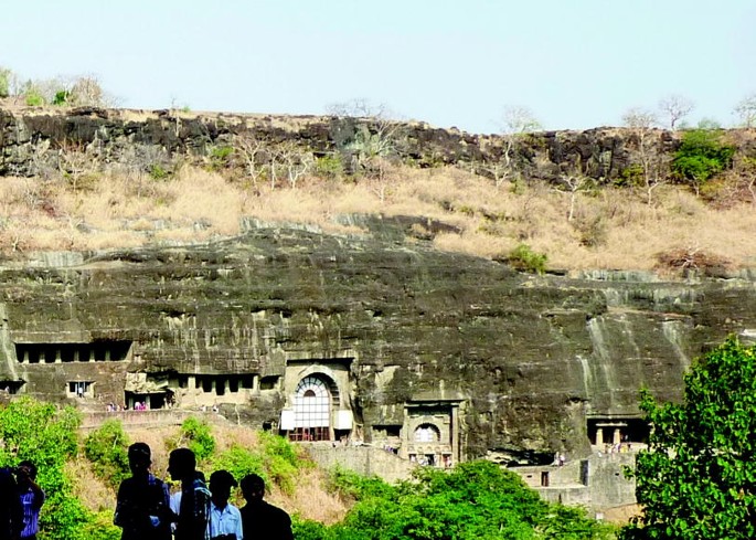
The Ajanta Caves overlooking the narrow, sinuous gorge of the Waghur (Waghora) River. The World Heritage Site, with nearly 30 caves, is located about 110 km north of Aurangabad. The caves are excavated in Deccan Traps basalts, exposed along the steep wall (~80 m high) of the horseshoe-shaped bend of the Waghur River gorge. The caves were excavated from ~2nd century BCE to 6th century CE. The caves are famous for their sculptures as well as paintings/frescoes. (Photo by Francesca Lugeri)
-
Monuments at Mahabalipuram (DI = 1984)—charnockite outcrops on sandy coast. A shore temple complex, including rock-cut chariots, sculptured scenes on open rocks and caves (7th and 8th centuries) (Fig. 3).
Fig. 3 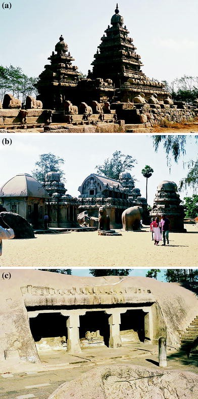
Historical monuments at Mahabalipuram (also Mamallapuram). The World Heritage Site is located about 65 km south of Chennai. a The seventh century shore temple overlooking the sea, b monolithic temples known as Five Rathas (chariots) carved from single chunks of exposed rocks, and c Athiranachanda Cave in the Tiger’s Cave complex area, near Mahabalipuram. The caves and temples are cut in outcrops of Archean charnockites (~2,500 Ma) on the sandy shore. There are reports that the December 2004 tsunami uncovered several ancient structures buried under the beach sand. (Photos by Vishwas S. Kale)
-
Temples and palaces (14–16th centuries) at Hampi (DI = 1986)—granitic area surrounded by boulder-strewn hills (Fig. 4).
Fig. 4 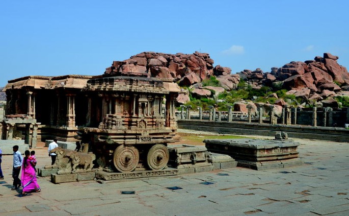
The ornate stone chariot at Hampi. The historical monuments at Hampi are situated on the southern bank of the Tungabhadra River, a tributary of the Krishna River. Once the seat of the mighty Vijayanagar Empire, the Vijayanagar city was built between ~1336 and 1570 CE. The undulating rocky terrain around the World Heritage Site is characterized by numerous block- and boulder-strewn granite nubbins and koppies. Two such boulder-strewn hills are seen in the background. (Photo by H. R. Mungekar)
-
Rock Shelters of Bhimbetka (DI = 2003)—area with interesting forms in sandstones. Huge overhangs and alcoves in massive sandstones in the foothills of the Vindhyan Ranges, displaying rock paintings that date from the Mesolithic to historical period.


2.2 National Geological Monuments: GSI Geosites
The Geological Survey of India (GSI) has enlisted 26 geosites and has declared them as National Geological Monuments (Anantharamu et al. 2001). Whereas majority of these sites are geologically significant sites, there are at least four sites that fall in the category of geomorphosites/geoheritage sites. These are (Fig. 1):
-
Sculpted forms in granite at Sendra, Pali District of Rajasthan
-
Silathoranam (meaning rocky arch) Natural arch in quartzite of Cuddapah Supergroup in Tirumala Hills, Chittoor District, Andhra Pradesh
-
Laterite in Angadipuram, Malappuram District, Kerala
-
Lonar Lake, a meteoric impact crater in Buldhana District, Maharashtra (“The Lonar Crater- The Best Preserved Impact Crater in the Basaltic Terrain”, this monograph)
In January 2013, a travel brochure on National Geological Monuments of India: Region South was released by Geological Survey of India (GSI 2012). The brochure, basically meant for tourists, gives description and location map of about a dozen interesting geosites in southern India. Apart from Silathoranam and Angadipuram laterite geosites, the Varkala Cliffs (geopark in Kerala) and Karai Badlands (Perambalur, Tamil Nadu) are also included in the travel brochure.
Many of the ancient monuments and archaeological sites under the protection and care of the Archaeological Survey of India (ASI) are oftentimes associated with remarkable landforms or landscapes. These sites include historical forts and ancient temples on hills, rock-cut caves and ruins of monuments at scenic locations.
3 Geotourism in India
The GSI website contains a section on ‘geotourism’, which includes photographs of interesting geological features (geophotos) and information about the National Geological Monuments in India. The photographs of glacial striations and erratics, talus cones, and colourful landscape of Lahul and Spiti Valley are most fascinating.
Geotourism, that is, tourism related to geomorphological sites and landscapes, is not a new phenomenon in India. Many well-known tourist destinations are, in fact, geoheritage sites. A good number of hill stations (hill resorts), first identified and developed by the British during the colonial period, are nestled at high elevations and provide spectacular views of the surrounding landscapes. Every year thousands of tourists throng to these hill stations (Table 1) to escape the scorching heat and dust during hot Indian summer for leisure and/or adventure.
Further, within the Indian subcontinent in general and the Indian Peninsula in particular, numerous historical forts were built on top of precipitous hills and escarpments for strategic reasons. Leading examples include Kangra Fort in Himachal Pradesh, Jhansi Fort in Uttar Pradesh, Hill Fort of Mandu in Madhya Pradesh, Raigad Fort in Maharashtra, Golkonda Fort in Andhra Pradesh, Bellary Fort in Karnataka, Rajagiri and Krishnagiri Forts, Gingee (Fig. 4, in chapter “Granite Landforms of the Indian Cratons” this monograph) in Tamil Nadu, etc. In 2013, six such hill forts of Rajasthan have been included in the UNESCO’s World Heritage List.
Likewise, innumerable temples or shrines have been built from ancient times atop hills and mountains or in caves throughout the subcontinent. Examples include Amarnath Cave shrine in Higher Himalaya, Vaishnodevi Shrine and Mansa Devi temple on Siwalik Hills, Dilwara temple at Mount Abu, the Great Stupa at Sanchi, the great stone statue of Gomateshwara Bahubali in Sravanabelagola in Karnataka, and Old Mahabaleshwar temple (source of Krishna River) and Talkaveri temple (source of Kaveri River) in the Western Ghat. Many more examples can be found in almost every region. Thousands of pilgrims and devotees have been visiting these picturesque geosites for centuries.
Among the most visible and outstanding elements of the landscape, that have attracted locals as well as outsiders alike from times immemorial, are the waterfalls. In the Indian subcontinent there is no dearth of cataracts and cascades. Although there are virtually countless waterfalls in the subcontinent, which acquire their most captivating form during the monsoon season, there are a few that have attained recognition as national landmarks due to unparalleled scenic beauty. Table 2 gives the list of some of the most popular and tourist-thronged waterfalls in India. All these waterfalls are geomorphosites because of their great aesthetic, cultural, economic (touristic) and scientific value.
4 Status of Geomorphosite Research
Geomorphosite research in India is still in its infancy. Notwithstanding the fact that a systematic and detailed inventory of geomorphosites and geoheritage sites important from the viewpoint of geotourism is awaited, a few efforts have already been made in this direction in the last few years. The first noteworthy attempt to record the geomorphosites/geoheritage sites in south India was made by the Karnataka Geologists’ Association (KGA), Bengaluru. The KGA has published an impressive monograph on “Geomorphology of Karnataka” (Ranganathan and Jayaram 2006). The volume contains over hundred colour photographs of exquisite landforms ranging from caves and stalagmites to inselbergs, bornhardts, nubbins, colourful badlands, waterfalls, beaches, caves and high-level erosional surfaces in the state of Karnataka. The pictures of three natural bridges, namely the Bheemana Kindi Arch in granite near Halagur, the Sidlapadi Arch in sandstone in Badami Taluka, and an arch in laterite near Talaguppa-Sirsi Cross are most interesting.
An inventory of glaciers in Indian Himalaya was published by Raina and Srivastava (2008). This “Glacier Atlas of India” includes maps, photographs and description of the geomorphological features from the entire length and breadth of Indian Himalaya. A collection of photographs of the landforms of the Himachal Himalaya was published by Bhargava et al. (2010). The book contains a good number of photographs with some description of lithology and structure controlled landforms, glacial and fluvial landforms, glaciers, lakes and other features in this part of Himalaya. The fourth noteworthy attempt was made by Parthasarathy et al. (2012) to prepare a photographic inventory of local landforms in Vaigai-Vaippar Basins in Tamil Nadu.
In the last week of May 2013, a 2-day national workshop on ‘Geoheritage—need for an Indian activism’ was jointly organized by the Department of Geology, Andhra University, the GSI, and the Indian National Trust for Art and Cultural Heritage (INTACH) at Visakhapattnam, to identify and preserve unique geological sites. An abstract volume was brought out on this occasion that gives information about numerous geological sites and some geomorphosites in southern, northern, northeastern, central, western and eastern India (Reddy 2013).
Even though a few attempts have been made in the last few years to record the geomorphosites/geoheritage sites in some parts of the subcontinent (Singh and Anand 2013), there is still lack of serious research dealing with the definition, mapping, assessment and conservation of geomorphosites and geoheritage sites (Reynard and Panizza 2005) in the subcontinent.
5 Potential Geomorphosites and Geoheritage Sites in India
The term ‘geoheritage’ is applied to sites or areas of geologic features, landforms, and culturally significant natural features and landscapes. Several international bodies are involved in this activity, such as the UNESCO’s Division of Ecological and Earth Sciences, the International Union for Conservation of Nature (IUCN), the International Union of Geological Sciences (IUGS), and the International Association of Geomorphologists (IAG).
The 18 landforms and landscapes described in some detail in the Part III (Chapters “The Siachen Glacier: The Second Longest Glacier Outside the Polar Regions”, “Ladakh: The High-Altitude Indian Cold Desert”, “The Vale of Kashmir: Landform Evolution and Processes”, “Duns: Intermontane Basins in the Himalayan Frontal Zone”, “The Chambal Badlands”, “The Kosi Megafan: The Best-Known Himalayan Megafan”, “The Sikkim-Darjeeling Himalaya: Landforms, Evolutionary History and Present-Day Processes”, “The Brahmaputra River in Assam: The Outsized Braided Himalayan River”, “The Meghalaya Plateau: Landscapes in the Abode of the Clouds”, “The Sundarbans and Bengal Delta: the World’s Largest Tidal Mangrove and Delta System”, “The Spectacular Belum and Borra Caves of Eastern India”, “Granite Landforms of the Indian Cratons”, “The Andaman Archipelago”, “Teri Red Sands, Tamil Nadu”, “The Laterite-Capped Panchgani Tableland, Deccan Traps”, “The Lonar Crater: The Best Preserved Impact Crater in the Basaltic Terrain”, “The Great Rann of Kachchh: The Largest Saline Marshland in India”, and “The Sambhar Lake: The Largest Saline Lake in Northwestern India”) of this monograph are so prominent and outstanding in the Indian context that they deserve inclusion in the national geoheritage list, as national landmarks. These sites/areas have international level of significance and appeal. Apart from these, there are countless sites or areas of scientific, cultural and socio-economic significance that could be designated as geomorphosites.
The IUCN, the advisory body on natural heritage to the World Heritage Committee, has recommended thirteen geo-thematic areas for identifying geological World Heritage. The relevant themes (geomorphic) could be used as guidelines to identify geomorphosites/geoheritage sites in India. Accordingly, a modest endeavor has been made to list some of the potential geoheritage sites within the Indian region (Table 3, Fig. 1) that are geological and geomorphological elements of nature, worthy of being conserved. The list is certainly not an exhaustive one but just a representative one. There are undoubtedly many more fascinating and exquisite places of natural wonders that deserve the geoheritage status and merit preservation for future generations.

Mount Girnar (1,117 m a.s.l.), a volcanic plug. View of the imposing hill from the base showing Ambaji Peak. The dome-shaped circular Girnar Hill Complex forms a prominent geomorphic feature of the Deccan Traps Region in Saurashtra that rises abruptly from the Kathiawad Plains. There are several ancient Jain and Hindu temples on top of Girnar. Junagadh town is located on the west of the complex. The hill complex (~175 km2) has four distinct geomorphic units (see inset Google Map) a the circular outer ranges of hills, b the central high hill, c radial ridges joining the central high hill to the outer hills, and d low-lying plains in the intervening area (Mathur et al. 1926). The Girnar Massif is made up of differentiated magmatic rocks like granophyre, basalt, dolerite, gabbro, pyroxenite, nepheline syenite and tonalite. The complex is believed to be pene-contemporaneous with Deccan Traps (~56–63 Ma). Besides Girnar, there are four other volcanic plugs in Saurashtra/Kathiawad, namely Barda, Alech, Chogat and Chamardi. (Text and photo by L. S. Chamyal and Nilesh P. Bhatt)

Garhbeta Badlands, West Medinipur District, West Bengal. Reaching up to 24 m in height locally and covering an area of 0.8 km2, the area is characterized by intense gullying. Gullying of the region was initiated by southward shift of a meander of the Shilai River into a Pleistocene lateritic terrain. The site is also an important storehouse of ichnofossils and petrified woods. (Text and photo by Sunando Bandyopadhyay)

The Nohkalikai Falls is developed on a cliff that retreated some 11 km along the course of the Pynjngithuli River from the southern edge of the Meghalaya Plateau. Initiating at 1,203 m a.s.l., the fall is a sheer drop of ~198 m on the Eocene sandstones of local Cherra Formation. Although the size of Nohkalikai’s catchment is just ~14 km2, its situation at 3.5 km east of Cherrapunji, one of the wettest places of the world with 11,780 mm of average annual rainfall, explains the high amount of discharge received by it. (Text and photo by Sunando Bandyopadhyay)

The Gersoppa or Jog Falls (~253 m) on Sharavathi River in Karnataka. This west-flowing Sharavathi River flows over the Mysore Plateau before leaping over the edge of the Western Ghat and entering the ~25 km long Gersoppa Gorge. The gorge provides evidence of the recession of the knickpoint associated with a river capture. The area is underlain by banded gneisses. The falls acquire their most captivating form when water is released from the Linganamakki Dam located upstream. (Text by Vishwas S. Kale and photo by H. R. Mungekar)

Bizarre wallforms in basalt seen on the gorge walls of the Kukdi River, near Nighoj, Maharashtra. The slot-canyon-like gorge (~250–300 m long and >15–25 m deep) exhibits intricately undulating walls, with remnants of multiple potholes (coalesced) of various dimensions. The remnants of potholes seen in this picture are several meters in diameter. Abrasional faces, flute marks, grooves, natural bridges and multiple isolated and coalesced potholes are the prominent features seen in the area. (Text and photo by Vishwas S. Kale)

Multiple river terraces (T1–T6) on the bank of Alaknanda River, Srinagar, Uttarakhand. The Alaknanda River drains through three major morpho-tectonic zones. These are the (i) Trans-Himalaya located north of the South Tibetan Detachment System (STD), the Higher Himalaya located between the STD and the Main Central Thrust (MCT) and the Lesser Himalaya located south of the MCT. The valley has preserved a spectacular sequence of fill and strath terraces particularly south of the MCT. The presence of both fill and strath terraces suggests that the fluvial landforms owe their genesis to a combination of climate (monsoon) and tectonics. (Text and photo by Navin Juyal)

Raised intertidal terrace and wave-cut notch, Diu Island, Saurashtra coast, Gujarat. The Saurashtra coast in western India consists of both relict and active geomorphic components. The cuspate coastline has bays, coves, creeks, ridges and lagoons. The ridges run parallel to the coast and invariably have curvilinear forms which probably represent relict barriers, bars or spits. At places, longitudinal lithified dunes (aeolinites) appear on top of the ridges. The ridges have a steep cliff face towards the sea, are backed by a set of parallel rows of aeolinite, and slope down towards the mainland Saurashtra plunging into relict/active lagoonal depressions. The cliffy coasts at places have preserved raised intertidal terraces and wave-cut notches which can be used to reconstruct the past sea-land level changes. (Text and photo by Navin Juyal)

Moraines and remnants of a proglacial lake (varve and rythemite), in Goting Basin in Himalaya, Uttarakhand. The basin lies in the transitional zone between a sub-humid south and semi-arid north of the Uttarakhand Himalaya. The southern extent of the basin is delimited by NW–SE trending South Tibetan Detachment System (STDS). The basin was carved by valley glaciers which have deposited the terminal moraines against the rising footwall of the STDS in the south. Following this, a proglacial lake came into the existence in which deposition of varve and rythemites occurred. Finally the pro-glacial lacustrine environment was terminated with the deposition of outwash gravel terraces. (Text and photo by Navin Juyal)

This landscape in Ladakh preserves some of the finest examples of alluvial fans and moraines of great antiquity. The Indus has drained down this valley since the Eocene (for >30 Ma) depositing the Indus molasse and has helped shape this mighty landscape. The Zanskar Range in the distance recorded a long history of continental–continental collision and has exceptional exposures showing numerous thrust duplexes. The concentric moraine in the middle foreground is one of the best preserved old moraines in the Himalaya and is dated to be about 150 ka. Recent exposure dating on summit tors in the Ladakh Range from where this photo was taken date to several million years and show that erosion of the summits is negligible. What is impressive is that this is an ancient landscape within the world’s most active mountain belt. (Text and photo by Lewis A. Owen)

The Western Ghat (Sahyadri) Escarpment in horizontally bedded Deccan Traps basalt flows (~65 Ma) at Mahabaleshwar. This photo taken near Auther’s Seat (~1,347 m a.s.l.), shows the western edge of the laterite-capped Mahabaleshwar Plateau (~1,220 and 1,438 m a.s.l.) (plateau not seen in the photo). The scarp at places has a sheer drop of many hundred meters (up to 900 m) and is embayed. The sinuous nature of the scarp, the deeply entrenched valley heads, the elongated offshoots and the occurrence of the beheaded valley of the Krishna River (behind this Ghat offshoot) suggest that the escarpment have receded east from an earlier position westward. All this geomorphic evidence indicates that the present scarp is erosional. (Text by Vishwas S. Kale and photo by H. R. Mungekar)
6 Concluding Remarks
The Indian subcontinent has extraordinary geoheritage. Whereas the Himalaya Mountains and the Western Ghat Escarpment are iconic landscape features, there are countless other fascinating and exquisite landforms and landscapes that have immense cultural, socio-economic and scientific value. All the geomorphosites or geoheritage sites described in Part III of this monograph as well as those listed in Tables 1, 2 and 3 of this chapter are important not only from the standpoint of public interest and economic benefits, but also from the viewpoint of geo-science studies. Such geomorphosites are critical to advancing knowledge about landscape evolution, geomorphic processes, geohazards, impact of climate change and the history of Earth. The need for promotion and conservation of such geomorphosites need not be overemphasized. To achieve this, first, the goal should be to identify, document and assess geomorphosites through a rigorous peer-review process. Various earth science associations and organizations in India, such as the Geological Society of India, the Indian Institute of Geomorphologists (IGI), etc. and the Ministry of Earth Sciences (MoES) as well as the Geological Survey of India have a critical role to play in this overdue activity. Second, one of the most challenging tasks in this endeavor is to convince the local communities, concerned government authorities (local, state and national) and geo-asset users (geo-tourists and service providers) about the geo-environmental value of these geomorphosites or geoheritage sites. The active participation of all these stakeholders is critical for the management and conservation of these geoheritage sites. Finally, environment-friendly and sound geo-conservation work and legislation that protect geoheritage sites are exceedingly vital from the standpoint of the future of geotourism in India.
References
Anantharamu TR, Bellur D, Bhasker AA (2001) National Geological Monuments. Geological Survey of India, Special Publication No. 61, vol vi, 98 p
Bhargava ON, Kumbkarni S, Ahluwalia AD (2010) Geomorphology and landscapes—illustrations from Himalayas. Technology Publications, Dehradun 211 p
Brocx M, Semeniuk V (2007) Geoheritage and geoconservation—history, definition, scope and scale. J R Soc West Aust 90:53–87
Gray M (2004) Geodiversity: valuing and conserving abiotic nature. Wiley, Chichester 434 p
GSI (2012) Travel brochure on National Geological Monuments of India: Region South. Geological Survey of India, Hyderabad, 12 p
Kale VS (2009) DEM-based studies of some outstanding fluvial landforms in India. In: Sharma HS, Kale VS (eds) Geomorphology of India. Prayag Pustak Bhavan, Allahabad, pp 59–68
Kale VS (2010) The Western Ghat: the great escarpment of India. In: Migon P (ed) Geomorphological landscapes of the world. Springer, New York, pp 257–264
Mathur KK, Dubey VS, Sharma NL (1926) Magmatic differentiation in Mount Girnar. J Geol. 34:289–307
Panizza M (2001) Geomorphosites: concepts, methods and examples of geomorphological survey. Chin Sci Bull 46(suppl):4–6
Parthasarathy GR, Rengan V, Arivalagan V (2012) Understanding geomorphology through inventory of landforms. Report submitted to University Grants Commission under UGC-UPE Project, 139 p
Raina VK, Srivastava D (2008) Glacier Atlas of India. Geological Society of India, Bangalore 315 p
Ranganathan N, Jayaram S (2006) Geomorphology of Karnataka. Karnataka Geologists' Association, Department of Mines and Geology, Bangalore 350 p
Reddy DR (ed) (2013) Proceedings of national workshop and brainstorming session on geoheritage: need for an Indian activism. Department of Geology, Andhra University, Visakhapatnam, 30–31 May 2013, 94 p
Reynard E, Panizza M (2005) Geomorphosites: definition, assessment and mapping. An Introduction. Géomorphol Relief Process Environn 3:177–180
Singh RB, Anand S (2013) Geodiversity, geographical heritage and geoparks in India. Int Jour Geoheritage 1:10–26
Author information
Authors and Affiliations
Corresponding author
Editor information
Editors and Affiliations
Rights and permissions
Copyright information
© 2014 Springer Science+Business Media Dordrecht
About this chapter
Cite this chapter
Kale, V.S. (2014). Geomorphosites and Geoheritage Sites in India. In: Kale, V. (eds) Landscapes and Landforms of India. World Geomorphological Landscapes. Springer, Dordrecht. https://doi.org/10.1007/978-94-017-8029-2_27
Download citation
DOI: https://doi.org/10.1007/978-94-017-8029-2_27
Published:
Publisher Name: Springer, Dordrecht
Print ISBN: 978-94-017-8028-5
Online ISBN: 978-94-017-8029-2
eBook Packages: Earth and Environmental ScienceEarth and Environmental Science (R0)