
Abstract
This chapter deals with main geomorphological properties of Croatia. The key elements of the geological predispositions are outlined as well as those of geodynamic evolution which, in conjunction with numerous exogenous processes, result in recent landform development. The main points of all important exogenous processes and landforms are presented: coastal, fluvial and fluvio-denudation, slope, aeolian and polygenetic. The main attention has been paid to karst and fluviokarst which cover almost 44% of the territory (the submerged karst excluded) therefore numerous recent research topics are outlined such as the development of structural geomorphological methods in karst, the research on coastal karst, glaciokarst, karst denudation measurements and cave microclimate. All this made a good basis for a detailed geomorphological regionalisation given in the chapter as well.
Access provided by Autonomous University of Puebla. Download chapter PDF
Keywords
1 History of Geomorphological Research
The development of geomorphology as a scientific discipline in Croatia started in the second half of the nineteenth century, primarily within the framework of physical geography, although geologists and foreign scientists also contributed to relief research, which was mainly directed towards the karst area. After the first period, which had brought a number of world-famous geomorphological works, between the world wars geomorphology experienced an obvious stagnation. The exception was the valuable karst investigations by Josip Roglić. Unfortunately, structural geomorphology was neglected and structural relief forms were identified with geological structures. In geography teaching fictitious conceptions about the characteristics and development of the Earth’s crust have persevered almost up to our days (Bognar 2000).
In the transitional period between the 1950s and the mid-1970s an increased interest of the society in ecology (especially in environmental protection), energy, and food problems, as well as in the necessity of the functional organization of living space has brought essential changes. By assembling geomorphologists in the framework of the state scientific project “Geomorphological mapping of the Republic of Croatia,” led by academician Andrija Bognar, in 1982, systematic geomorphological investigations and morphogenetic and morphostructural mapping started.
Modern approaches and research methods are being introduced gradually. Morphostructural analysis is for the first time used in solving the problems of endogenic relief. Various quantitative methods of morphometry, morphography, and morphodynamics are applied for defining particular stages in geomorphic evolution, as well as modern methods of field work, geomorphological mapping on morphogenetic and morphostructural principles, and remote sensing. It should be pointed out that if needed, geomorphologists also contribute to geological mapping, sedimentological, chemical, and mineralogical analyses, especially those concerning loess.
The systematic education of a new generation of young scientists was an important condition for a renewal of geomorphology and physical geography in Croatia and for the successful completion of the geomorphological mapping project of the Republic of Croatia. The Croatian Geomorphological Society was established in 2003 and it is a member of the IAG (International Association of Geomorphologists). Croatian geomorphologists are also active in the INQUA (International Union of Quaternary Research). During the past 25 years research has been dedicated to exogenic processes, structural quantitative, and regional geomorphology as well as to geomorphological mapping. The application of geomorphological research findings becomes more and more widespread in practice as well. In that way the reputation of geomorphology has increased in the earth and natural sciences, as well as in ecology and socio-economic development of the Republic of Croatia.
2 Geological and Geodynamic Setting
From the geodynamic point of view the Republic of Croatia (Fig. 12.1) belongs to the Late Cainozoic Alpine-Himalayan mountain belt. The Croatian territory, with a surface of 56,594 km2 (Statistical Yearbook 2009) encompasses three main geomorphological units: the Pannonian Basin (lowlands, hills and scattered mountains), the mountain system of the Dinarides, and the Adriatic Basin (Bognar 2001).

The topography of Croatia
The Dinarides of ca 700 km length represent a complex fold-and-thrust belt developed along the eastern margin of the Adriatic microplate (Dewey et al. 1973), connecting the Southern Alps with the Albanides and Hellenides. They were formed as a result of collision between the Adriatic and European plates, beginning in the late Cretaceous and reaching its peak in the Oligocene and Miocene epoch and finally resulting in the uplift of the mountain chain (Velić et al. 2006). The Dinarides can be divided into two genetically different parts: the Outer (Karst or External) Dinarides along the Adriatic Sea, composed mostly of the remnants of the Adriatic Carbonate Platform, its basement and overlying deposits, and the Inner (Internal) Dinarides, situated between the Outer Dinarides and the Pannonian Basin, composed of passive and active continental margin rocks including ophiolites (Pamić et al. 1998). The Outer Dinarides are characterized by four major sequences (Velić et al. 2006) ranging from Middle Carboniferous to Eocene/Oligocene, all within different paleogeographic settings (Fig. 12.2):

Overview geological map of the Republic of Croatia (Croatian Geological Society, Zagreb 1990)
-
1.
Middle Carboniferous – Middle Triassic
Over more than 80 Ma the area represented an epeiric carbonate platform belonging to the NE margin of the Gondwanan part of Pangea producing mixed siliciclastic-carbonate depositions.
-
2.
Upper Triassic – Toarcian
45 Ma of shallow-marine carbonate deposition from the Late Triassic to Toarcian took place on a very wide carbonate platform area formed on the Adriatic basement, partially separated from Gondwana, and therefore lacking any continental influence. Consequently, the area of the future Karst Dinarides represented only a small part of this huge depositional area (Southern Tethyan Megaplatform of Vlahović et al. 2005) characterized by very similar depositional sequences.
-
3.
Toarcian – Cretaceous
This major sequence encompasses almost 120 Ma and it is characterized by a specific paleogeographic entity – the Adriatic Carbonate Platform (AdCP). This platform become a separate entity during the Toarcian Oceanic Anoxic Event, when former megaplatform become disintegrated into several smaller “isolated” platforms (including the Apenninic, Apulian, and Adriatic Carbonate Platforms) surrounded by deeper marine basins (including the Adriatic basin and the Bosnian and Slovenian troughs) (Vlahović et al. 2002, 2005).
-
4.
Palaeocene – Oligocene
The final major sequence comprises approximately 40 Ma of deposition within specific environments, mostly controlled by intense synsedimentary tectonics resulting in significant compression of the area and formation of asymmetrical flysch basins within the former platform (Velić et al. 2006).
The development and tectonics of the (Outer) Dinarides are very important for geomorphic evolution in Croatia. The whole mountainous system is named after the mountain Dinara (1,830 m). Besides a great geological, geophysical, and geomorphological diversity, as well as an intensive disruption, the Outer Dinarides represent a cohesive geotectonic entity of uniform geodynamic evolution. They also reveal similar structural properties like the predominantly Dinaric strike (NW-SE), apart from Central Dalmatia, where the Hvar strike (east to west) becomes increasingly obvious, as well as the predominance of tangential folded and faulted southwest to south verging structural units.
Three main structural units can be differentiated in the Outer Dinarides (Herak 1991; Prelogović et al. 2004): the Dinaric (2), the Adriatic (3), and the Adriatic microplate (4), (Fig. 12.3). The contact with the Inner Dinarides, Supradinaric (1) is also shown in Fig. 12.3. The Dinaric and Adriatic structures are characterized by inverse and thrust relations. They are the consequence of gradual movements of the Adriatic microplate (Adria) and of the Earth’s crust deformation in the narrow zone of the European plate. The process lasted for millions of years. The Adriatic microplate is pushed by the African plate in northeastern and northern directions. The strong indentation of the small Adriatic microplate to the large European plate results in a complete closure of the areas around the present Adriatic Sea. The remaining narrowed area of the Adriatic microplate still relies on the African plate and moves towards the north-northwest. The boundaries of the structural units are defined by major faults (Fig. 12.3). On the surface they represent zones of few kilometers width. The faults mostly run parallel to steep mountain slopes or rows of islands.

Structural map of the Outer Dinarides (Prelogović et al. 2004). 1 Main structural units: Supradinaric (1), Dinaric (2), Adriatic (3), Adriatic microplate (4), 2 Main lineaments: [1 – Idrija–Čabar–Ogulin–Bihać fault; 2 – Fault Trnovski gozd–Ilirska Bistrica–Rijeka–Vinodol; 3 – Velebit fault; 4 – Fault Promina–Moseć; 5 – Fault Mosor–Biokovo; 6 – Fault Ploče–Dubrovnik–Bar; 7 – Fault Trieste–Učka–Lošinj; 8 – Fault of Dugi otok; 9 – Fault Vis–Lastovo–Dubrovnik], 3 Faults which delimit structural units and faults within the zones, 4 Reverse fault, 5 Normal fault, 6 Strike-slip fault, 7 Movement direction of the Adriatic microplate
The lineaments that reveal the borders of the Adriatic microplate (4) and the Adriatic (3) must be emphasized. They are the first thrust faults that marked the strong tectonically and seismically active zones. These faults are represented by three large zones: the Trieste–Učka–Lošinj (7), the Dugi otok (8), and the Vis-Lastovo-Dubrovnik (9) lineaments. The boundaries of the Adriatic and the structure of Dinaric are determined by the following inverse faults: the Trnovski-Gozd-Ilirska Bistrica-Rijeka-Vinodol (2), the Velebit (3), the Promina-Moseč (4), the Mosor-Biokovo (5), and the Ploče-Dubrovnik-Bar (6) lineaments. The boundary between the Dinaric and the Supradinaric units (1) follows the Idrija-Čabar-Ogulin-Bihać faults (1). The faults are of variable inclination and character. Dextral and transcurrent movements are important along some sections of the faults.
Tectonic activity and the deformations of geological structures are also determined by the disposition of different rock masses, their sizes and locations within the regional structural Dinaric unit (2). The masses of this unit directly resist the movements of the Adriatic microplate. The unit of the Adriatic (3) represents in fact a large area of Earth’s crust deformed by tectonic processes of action and reaction between the Dinaric and Adriatic. This is the reason why the area of Outer Dinarides is characterized by thrust structures and shallow crustal folds. The rock masses of the Adriatic microplate underlie the structures of the Adriatic (3), where they also come into contact with the rock masses of the Dinaric (2) in oblique inclined zones that are seismotectonically the most active.
The tangential movements seem to be relatively small and only locally achieve 10 km. Nevertheless, if the entire rock mass is taken into account up to the Mohorovičić discontinuity, the amplitudes are probably bigger. Apart from tangential movements, there are also horizontal movements of the neighboring tectonic units or blocks, especially along north-northwest–south-southeast faults. The amplitudes of neotectonic subsidence in the Adriatic basin vary up to 6,000 m, while the highest mountains along the coast reach 1,500 m elevation (Prelogović et al. 1982).
On the basis of the highly accurate GPS measurements of the geodynamic network CRODYN, a geodetic model of recent tectonic movements was established by Altiner (1999). The model encompasses GPS points in Croatia and Slovenia. For these points the values of heights, horizontal and vertical components of the movement velocity vector were calculated (Fig. 12.4).

Surface deformation analyses indicate zones of various deformations in the Outer Dinarides. Two main zones of extension and two zones of compression were identified. A zone with extraordinary extension, 6 mm year−1 per 10 km, was discovered in central Istria and southern Slovenia. This is at the same time the zone of maximum total deformation of the upper Earth’s surface. A major zone of maximum compression has been discovered northeast and southeast of the area. The magnitudes of compression are somewhat smaller (3–5 mm year−1 per 10 km) (Altiner 1999). The geological evidence on tectonic movements of the Adriatic microplate and the high concentration of the earthquakes confirm the existence of compression zones in this area. Almost all the velocity vectors (Fig. 12.4) indicate north-northwest direction, only some of them, like the Bakar, Split, and Sveti Ivan, show northeast direction. This indicates a moderate rotation of the Adriatic microplate.
The Croatian part of the Pannonian Basin is basically a mountain and basin region today. The southwestern part of Croatia represents a contact zone of the Pannonian Basin in the west with Fore-alpine structures in the north and with the Dinarides in the south. This is mostly due to the fact that four major tectonic boundaries join here (Fig. 12.5): the Periadriatic (Insubric) Lineament (PAL), the Mid-Hungarian Lineament (MHL), the Sava Fault (SaF), and Drava Fault (DF) (Tomljenović and Csontos 2001). This Zagorje–Mid–Transdanubian Zone (ZMTZ) is composed of mixed Alpine and Dinaric lithologies (Tomljenović 2000). The precise locations of these boundaries and their kinematic history in the area are still ambiguous due to a complex Neogene deformation and a thick southeastern Pannonian Basin cover. Characteristic major tectonostratigraphic units of the ZMTZ are best preserved in the Mt. Medvednica, which can be traced along a northeast strike for about 40 km (Tomljenović and Pamić 1998).

Structural map of the contact zone between the Alps, Dinarides and Pannonian Basin (Tomljenović and Csontos 2001)
In the north, the Dinarides are bounded by the Tisza Unit, a fragment detached from the Eurasian southern margin (Pamić et al. 2000). Paleozoic crystalline rocks of the South Tisza, outcrop in the Moslavačka gora and the Slavonian Mountains (Psunj, Papuk and Krndija) and are today disconformably overlain by much more subordinate Mesozoic sedimentary rocks. Rocks of both age groups were penetrated by numerous oil wells (Pamić 1986) beneath a thick sedimentary fill of the South Pannonian Basin. Predominant Paleozoic rocks are represented by regionally metamorphosed sequences, migmatites and granitoides (Pamić et al. 2000). Regionally metamorphosed sequences are composed mainly of paragneisses, mica schists, and subordinate interlayers of orthoamphibolites and marbles in their medium grade parts, and greenschists, phyllites, and chloritoid schists in their lower grade parts.
Migmatites originated from the highest-grade paragneisses and mica schists of the surrounding regionally metamorphosed sequences. The petrography of the migmatites is the same as the petrography of the adjacent S-granite plutons.
S-type granites make up the cores of the Mts. Moslavačka gora and Papuk plutons. These rocks crystallized from magmas originating from partial melting of the surrounding regionally metamorphosed rocks, but also from the metasediments included in the underlying continental crust (Pamić et al. 1996). The Slavonian granitoides are of Variscan age (Pamić et al. 1988). I-type granitoids occur as small bodies only in higher-grade parts of the metamorphic sequences of the Slavonian Mountains. The heterogeneous association of igneous rocks is of oceanic crust origin, suggesting that they might have been generated along an active Paleotethyan margin, subduction zone (Pamić et al. 1996).
Field relations and petrological-geochemical data including radiometric ages provide evidence that regionally metamorphosed sequences, migmatites and granitoids represent a single geological-petrological entity of Variscan origin. The regionally metamorphosed sequences originated from a Silurian-Devonian sedimentary complex interlayered with tholeiitic basalts along the active Paleotethyan margin together with I-type granitoids of subduction-related plutonism (Pamić et al. 1996).
Mesozoic formations are of more limited extension both on the surface and in the Pannonian basement. 50–40 Ma ago, in the Eocene, the South Tisza Unit come into contact with the Dinarides. (The Pannonian Basin did not yet exist at that time.) In the Oligocene (35–25 Ma ago) along the contact of the South Tisza Unit and the just elevated Northern Dinarides major fault movements produced elongated separate basins with saline to fresh water sedimentation accompanied locally by strong volcanic activity. Those sediments principally encountered in oil wells point to the initial formation of the Pannonian Basin (Pamić 1999). In the early Miocene (19–18 Ma ago) important changes led to the formation of the Pannonian Basin (Royden et al. 1983). The changes have been initiated by the uplifting of the upper mantle to the shallow depth of 25 km. Extensional tectonics in the southeast Pannonian Basin started between the Oligocene and the Early Miocene. Three main stages in the structural development of the Croatian part of the Pannonian Basin are differentiated:
-
The Oligocene and the Early Miocene characterized by extensional tectonics;
-
The Early and Middle Miocene with major extensional processes and
-
The Pliocene and Quaternary with prevailing transpression (Prelogović et al. 1998).
In the main extensional phase during the Early and Middle Miocene, the Sava and Drava Basins and minor sub-basins took shape. The extension-related depositional cycle ended in Pontian times and a new tectonic phase began in the Pliocene. A transpressional wrench-fault model is established for the Pliocene to recent evolution of the SW Pannonian basin, which is regarded as a neotectonic period (Fig. 12.6). Thick alluvial deposits accumulated in the major valleys of the Sava and Drava Rivers.

Structural map of the Pannonian Basin in Croatia (Prelogović et al. 1998)
The recently studied mechanisms of earthquakes in Northwestern Croatia after 1908 consistently indicate predominantly compressional tectonics with reverse faulting in the central part versus strike-slip motions in the western and eastern sectors (Herak et al. 2009).
3 Geomorphological Regions
As far as exogenic processes are concerned, Croatia belongs to the temperate fluvio-erosional zone, dominated by fluvial processes in the north and karst and fluviokarst processes in the south. A complex tectonic evolution is coupled with the influence of different exogenic processes (slope, fluvial, abrasional, glacial, periglacial, karst, fluviokarst, and aeolian processes) in the various zones of elevation (Table 12.1).
Owing to its geomorphological and geostructural position and to its form and size Croatia is divided into three main geomorphological regions: the Dinaric mountain system, the Adriatic, and the Pannonian Basin, which are further subdivided into several macro-geomorphological regions (Fig. 12.7):

Geomorphological units in Croatia (mega and macroregions – Bognar 2001)
-
1.
Panonnian Basin
-
1.1.
East Croatian Plain with Upper Podravina
-
1.2.
Slavonian block mountains with Požega basin and Sava River valley
-
1.3.
Basin of NW Croatia
-
1.4.
Mountainous-basin region of NW Croatia
-
1.1.
-
2.
Dinaric Mountain Belt
-
2.1.
Mountainous Croatia
-
2.2.
Istrian peninsula with Kvarner coastal region and archipelago
-
2.3.
NW Dalmatia with archipelago
-
2.4.
Central Dalmatia with archipelago
-
2.5.
Southern Dalmatia with archipelago
-
2.1.
-
3.
Relief of the Adriatic Sea Bottom
-
3.1.
Adriatic shelf (part)
-
3.2.
Central Adriatic bank
-
3.3.
Southern Adriatic Basin
-
3.1.
The further subdivisions into meso, sub, and microregions (Bognar 2001) is based on morphostructural, morphogenetical, lithological, and orographical conditions. For the identification of geomorphological regions, morpholithogenic factors were evaluated individually and integrally. Basically, every region was identified by the homogeneity and similarity of particular conditions. When delimiting mountain regions and the sea-bed of the Adriatic basin, structural-geomorphological and morphoevolutionary conditions were decisive, and for lowland regions, the morphogenetic and lithological conditions were the most important. In certain cases it is necessary to use the criterion of spatial connections.
On the basis of the above mentioned principles seven types of geomorphological regions are distinguished in Croatia: mountain, hill, plateau, basin, valley, lowland, insular, and submarine regions. Three types of mountain macro and mesoregions were identified:
-
1.
Remobilized block (faulted-folded and faulted-folded-imbricated) mountain ranges and massifs of Slavonia and basin-and-range regions of North-Western Croatia;
-
2.
Mountain ranges and massifs and mountain groups of folded-faulted-thrusted structures of the Dinaric mountain system;
-
3.
Mountain ranges, mountain ridges and mountain groups of folded-faulted-imbricated structures of the Outer Dinarides geotectonical zone (Fig. 12.8).
Fig. 12.8 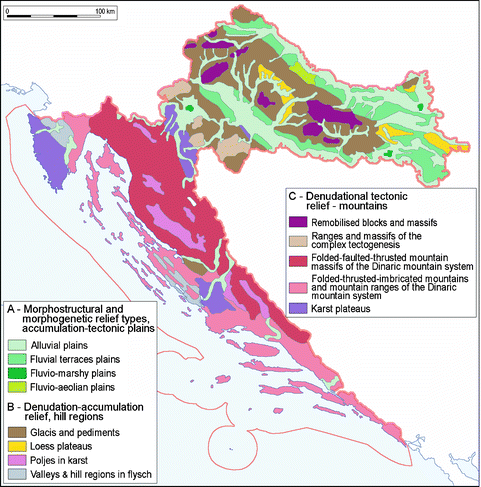
Relief categories in Croatia (Bognar 1995b)

Different types of hill regions formed by derasional-erosional and derasional-corrosional processes during the Tertiary-Quaternary in clastic sediments and carbonate rocks on neotectonically elevated structures. Plateaus are of polygenetic origin, or they are also formed in thick loess accumulations associated with neotectonically elevated block structures. The plateaus on carbonates form meso and subregions in the mountain system of Dinarides, while loess plateaus occur in the Pannonian Basin. As the expression of complex geotectonical structure and geomorphic evolution, as well as of differential geotectonical movements in the mountain system of the Dinarides and in the Pannonian Basin, smaller basins have been formed. They are mostly intermontane basins, which are, on the basis of their morphostructural and morphogenetic development, included into larger mesoregions. Valleys represent separate sub and microregions. Lowland geomorphological regions can be subdivided into three basic types: (1) fluvial floodplains and low-level terrace plains, (2) fluvial-marshy plains, and (3) fluvio-aeolian plains (Fig. 12.8). The insular relief of the northeast part of the Adriatic Sea maritime zone geotectonically belongs to the zone of the Outer Dinarides with prevailing folded-faulted-imbricated geological structure. As a rule, particular mesoregions are identified on the principle of the homogeneity of morpholithogenic conditions, and of spatial connections: the islands of the Kvarner Bay, North, Central and South Dalmatia. Submarine types of geomorphological regions have been delineated primarily on the principle of morphostructural homogeneity: the macroregions of the North-Adriatic Shelf, the Central Adriatic Bank, and the South Adriatic Basin.
About two-thirds of Croatian territory have been geomorphologically mapped to various scales. The Geomorphological map of the Republic of Croatia was published in the framework of the geomorphological mapping of Yugoslavia (Bognar and Blazek 1992). The new geomorphological map of Croatia at 1:500,000 scale is recently published (Bognar and Pahernik 2011). Modern geomorphologic mapping relies on a geomorphological database of 1:100,000 scale.
4 Karst and Fluviokarst Research
Karst and fluviokarst are particularly important relief types since they cover almost 43.7% of Croatian territory (Figs. 12.7 and 12.9; Table 12.2) (the submerged karst of the Adriatic Sea bottom excluded). It consists of two spatial units: The larger classic Dinaric karst belt (2 on Fig. 12.7) is formed of thick Mesozoic and Paleogene carbonates (Fig. 12.2). This is the area with typical karst hydrology and diverse karst phenomena. All types of corrosion features such as rillenkarren, covered karren, wall karren, meandering karren, fissures and network karren, exhumed karren, solution pans, pot-like karren, root karren, debris karren, karst tables, karren wells, karren fields, and surf karren can be found out (Perica et al. 1999–2001). The karren in central and lower parts of the Dinaric Mountains are by the rule larger than their higher-located counterparts. A good example of this can be found on the southwest flank of the Velebit Mountains.

Morphogenetic types of relief of the Republic of Croatia, Source: Geomorphological map of Croatia, 1:500,000 (Bognar and Pahernik 2011). 1 Fluvial and denudational-accumulational relief, 2 Terraces plains 3 Fluvial-denudational relief, 4 Fluviokarst relief, 5 Karst, 6 Glacial and periglacial, 7 Piping relief, 8 Aeolian relief
Dolines as diagnostic karst features are particularly numerous in the Dinaric part of Croatia. In the geodatabase 349,324 dolines are recorded. The density is highest in the Gorski kotar area (242 dolines km2). Dolines can appear individually, as is the case on the littoral slopes of the Dinarides and on different islands, but usually they form doline fields and long rows along contacts, on fractures, joints and smaller faults. Near mountain summits they appear as doline fields. The extremely high density makes some parts look like a cockpit karst. Mountain tops are also characterized by megadolines, more than 100 m deep (e.g., at the Rožanski kukovi in the Velebit Mountain, Biokovo). The elevated relief of the Velebit (but also the Risnjak and Biokovo) Mountains was glaciated during the last glacial maximum so the pre-existing karst depressions have been transformed by ice (Fig. 12.9) into glacial cirques and megadolines (Bognar et al. 1991; Bognar and Faivre 2006). The final melting of glaciers also left imprints in caves (Bočić et al. 2008). Today, during winter, dolines accumulate snow and ice on their bottoms with thermal inversions that explains the persistence of karstification throughout the year. At present, periglacial and nival processes (Perica et al. 2002) also strongly influence geomorphic evolution.
A digital database of karst depressions in Croatia has been recently set up and 161 large depressions have been distinguished (Pahernik et al. 2010). Poljes are typical landscape features in karst terrain with extensive flat bottoms used as arable land, with springs, ponors, estavelas, and sinking streams. The evolution of these large polygenetic depressions are determined by geological structure, karst, fluvial, and slope processes. Their dominant morphological characteristic is the elongated Dinaric axis (northwest–southeast); they are several times longer than wide. Their surfaces are covered with deposits of mostly Quaternary and Neogene age. Despite regular inundations caused by difference between large inflow and limited ponor capacities, poljes are well-populated areas. They are surrounded by rocky hills and mountains covered with forests and grasslands important in traditional karst economy. The largest among them is Ličko polje (465 km2). The largest stream is Lika river (78 km long – the longest sinking river in Croatia and the second longest in Europe), which flows towards NW to the Lipovo polje, where it sinks in the 2,240 m long Markov ponor of the Velebit Mountain. It flows further underground towards springs and Adriatic submarine springs between Sv. Juraj and Jablanac.
Karst plateaus are, together with karst poljes, the most extensive landforms in the Dinaric karst. They are characterized by polygenetic and polyphase origin. At a small scale, karst plateaus are large flat areas with very low relative relief. The Dinaric karst plateaus are sometimes isolated plateaus on the margins of the Dinaric karst. In the second case they can be almost regarded as a part of the polje floor, and in the third case, they appear as small tectonically dismembered and uplifted plateaus in mountainous areas. In the Croatian part of Dinaric karst there are three major karst plateaus: the Istrian, Karlovac (Una-Korana), and North Dalmatian plateaus, together ca 4,000 km2 in area (7% of Croatian territory and 14% of total Croatian karst area). Numerous investigations explored the origin of karst plateaus (e.g., Pavičić 1908; Roglić 1951, 1957; Herak 1986; Bahun 1990; Bognar 1994, 2006). Three groups of theories were proposed: erosional, corrosional, and abrasional theories. Their genesis can be placed between the Mesozoic and the Pleistocene. Recent research is conducted in the area of Slunj plateau (Bočić 2009), on the extensive Karlovac (Una-Korana) karst plateau expanding between the Dinaric System in the southwest and in the Pannonian Basin in the northeast. The oldest rocks are Permian sandstones, and most of the area is built of the Mesozoic platform carbonate rocks, in places transgressively covered by Miocene, Pliocene, and Quaternary lacustrine and alluvial deposits. Main structures and faults stretch in the Dinaric direction. Periods of intensive exogenic processes principally occurred during and after orogenic phases interrupted by transgressions. In the post-Miocene period, the geomorphic evolution was significantly influenced by the denudation of Neogene clastic sediments and by the gradual exhumation of the carbonate bedrock. During that process, the karst relief area increased at the expense of the fluvio-denudational relief (Fig. 12.10). It resulted in development of numerous karst forms (dolines, grikes, uvalas), but also of karstified remnants of the surface paleodrainage network (dry and blind valleys). In those conditions a number of, mainly horizontal, caves developed (Bočić 2003a, b).

Denudation of the clastic cap-rock with a gradual exhumation of the carbonate bedrock and disintegration of the surface paleodrainage network in the area of Slunj karst plateau (Bočić 2009)
The Dinaric karst is rich in underground karst features (Bočić and Kuhta 2004). There are over 9000 caves and shafts. The longest caves (four of them longer than 6 km) are mostly found in the Inner karst belt, particularly between Kordun and Ogulin-Plaški depression. Caves form under vadose, epiphreatic, and shallow phreatic conditions and therefore branched multilevel caves are the most common type. The longest one is the Đulin ponor–Medvedica cave system (16.4 km long) developed by action of the Dobra sinking river. The deepest shafts occur in thick Mesozoic limestones and Paleogene Jelar breccia sediments in high karst belt of the Dinarides, especially in the Velebit Mountain (the 1421 m deep Lukina jama–Trojama system shaft and the recently discovered, 561 m deep and 20 km long, Kita Gaćešina–Draženova puhaljka system).
A smaller part of Croatian karst is insular karst, scattered in the Pannonian Basin (Medvednica, Ravna gora, Papuk), developed in Mesozoic and thinner Neogene carbonates (1 on Figs. 12.7 and 12.9). It is characterized by smaller depth of karstification (mostly up to 100 m). Main surface forms are small and shallow dolines, caves, and shafts (mostly up to 50 m long and deep). The single largest cave is the 7.1 km long Veternica cave (in the Medvednica Mountain) formed by the action of former stream at the transgressive contact of Upper Triassic dolomite and dolomitic limestone with Neogene Lithotamnium limestone (Buzjak 2002).
4.1 Structural-Geomorphological Research in Karst Terrains
The relation between the geological structure and the landscape has always been an important subject in geomorphology, but, in the last few decades, interest in this topic has further increased. Recent papers show that for the explanation of karstification, analyses of the geometry of fissures network and of the orientation of the stress that has affected the massif are necessary. This means that the reconstruction of tectonic history is inevitable for the study of karstification.
Due to this strong relationship between karst and geological structure different karst landforms have been used in the structural geomorphological analysis. The most often analyzed forms are dolines, uvalas, karst poljes, and caves, followed by the analyses of crests and drainage networks. Various methods have been applied in the Velebit Mountains (Faivre 2000).
Recent morphostructural analyses are focused on dolines and on the relations between surface and underground karst features using GIS and combining geomorphological and speleological research. The significant prevalence of carbonate rocks (limestones and, to a lesser extent, dolomites) affected by tectonic movements enables the formation of typical karst landscape. Tectonic movements are crucial to provide the necessary relief (potential energy) for karstification. The application of geomorphometric techniques to karst features, particularly to dolines, began long ago and is still an important tool in karst geomorphology. The use of GIS allows ever-refined morphometric analyses that were applied in the study of Croatian karst by Mihljević (1994, 1996), Faivre and Reiffsteck (1999a), Pahernik (2000), and Faivre and Pahernik (2007).
Recent research in the Croatian karst shows that the spatial distribution of dolines is closely related to the recent deformation of the area (Faivre and Reiffsteck 1999a, b, 2002). In the karst domain, dolines can be used as a sensitive indicator of tectonic activity. The highest density of dolines is observed in the central parts of structural blocks (Faivre and Pahernik 2007), while in the main fault zones they occur rather sparsely. Analyzing their distribution according to the distance from major faults, it is found that close to the faults dolines show (near) clustered distribution, while with increasing distance, in the central parts of the blocks, where density as a rule increases, the distribution approaches random (Faivre and Pahernik 2007). This confirms that the spatial distribution of dolines seems to be of distinctive type, taking into account their position according to major faults.
The close relationship between the distribution and type of landforms and tectonic forces has been also observed studying the shape of ridge crests. For example, by the change in stress during the latest tectonically active stage, the rotation of morphostructures started, followed by gradual arc bending of the Velebit Mountains lineament. The rotation is followed by transport and stuffing of rock masses mainly towards the southeast. This is reflected in the increasing heights of mountain ridges in this very direction (Mihljević 1995). As rotations have been prograding, a differentiation between morphostructural units occurred. The consequences are arc-shaped faults and the related arc-shaped mountain ridges. The kinematic model of counterclockwise rotation of structures is recognized as the fundamental cause of arc-shaped mountain ridges, characteristic of the entire Velebit Mountains (Faivre 2007). The different tectonic regimes acting on the studied area are one of the main causes of the spatial distribution of landforms in the present-day landscape.
Another aspect of the close relationship between karst and tectonics can be demonstrated again on the example of the Velebit Mountain, which is extremely rich in caves. The mountain summits are characterized by numerous extremely deep pits. From the 20 deepest pits in Croatia, 12 of them are in the Velebit area, and 9 of them in the northern Velebit. The formation of pits is greatly predisposed with tectonic and hydrogeological properties resulting from prolonged karstification also influenced by past glacial processes.
4.2 Exogenic Processes in Karst Terrains
The measurements of the karst denudation rates, using the method of limestone tablets, have intensified since 2007. Tablets are set in the soil and in the soil/bedrock contact at numerous sites like Žumberak, Velebit Mountain, Gorski kotar, Krka river valley, Cres, and Vis islands. Karst denudation is also measured in submerged cave passages in phreatic conditions like in the karst springs of Zagorska Mrežnica, Cetina, and Slunjčica rivers. Earlier research in the Kapela and Velebit Mountains (Pahernik 1998; Perica 1998) shows positive correlation between surface corrosion intensity and amount of precipitation but negative correlation with air temperature above the tree line. In the Bjelolasica area Pahernik (1998) measured 35–40% higher intensity for subcutaneous corrosion (up to 7.28 mm 10−3 year−1) compared with surface corrosion (up to 6.74 mm 10−3 year−1).
The geoecological research of cave and doline microclimates has become particularly intensive and shows that doline microclimate is conditioned by geographical position, altitude, and morphology as well as by local vegetation cover. According to yet unpublished findings, microclimate modifies karst and ecological processes as well as the flora in the dolines, especially in mountain areas with distinct temperature inversion. Soil temperature affects soil biochemical processes and, through CO2 production, the rate of subcutaneous solution. Microclimate measurements, floristic, and pedogeographical investigations are carried out in four major dolines in the Risnjak, Kapela, Velebit, and Žumberak Mountains. In a 1-year long measurements in the Balinovac doline (Velebit Mountain) mean annual air temperature varies from 6.06°C at the doline bottom (at 1,434 m elevation) to 7.32°C at the top of the slope of southern exposure (1,513 m). Air temperature inversion typical of the mountain dolines and reflected in vegetation was recorded. Relative air humidity is higher on north-exposed slopes (84–86%), as expected; however, this is insignificant compared to southern slopes (80–81%). It has been established that 149 plant taxa grow in the studied part of the Balinovac doline, in three main soil types: haplic Cambisol, colluvic, rhodic molic, umbric Leptosol, calcaric and leptic, caltic Luvisol, abruptic, skeletic, clayic. Based on the indirect gradient analysis of ecological parameters, it has been determined that habitats in half-shade with arid soils poor in nutrients and humus, in which plants of the mountainous belt mostly grow, dominate the southern slopes. Shady habitats prevail on the northern slope with more humid soils, richer in nutrients and humus, where plants of the sub-alpine belt mostly grow. According to the indirect gradient analysis, on the doline bottom transitional habitats occur.
The research of cave microclimate (measured in caves of different climatic zones: Cfa, Cfb, and Df according to Köppen) shows that microclimate depends on the geographical position, altitude, influence of the sea, characteristics of the entrance zone (its exposure, morphology, vegetation cover), number and elevation of entrances (controls air circulation through passages), and cave hydrology. As the cave microclimate is a very important factor for cave management, microclimate has been studied in 50 caves of different karst regions in Croatia (Buzjak and Paar 2009). The measurements were performed with classical mechanical bimetal thermohygrographs and data loggers. If cave microclimate is compared to surface climate, lower air temperatures in the warm periods and higher air temperatures in the colder periods are observed. Relative humidity is high (95–100%). All cave microclimate parameters show smaller diurnal, monthly, and seasonal oscillations compared to the surface. Near the entrance of the cave the oscillations of all measured parameters are the greatest due to the surface atmosphere and hydrosphere influences. Further back from the entrance the surface effect quickly decreases and all amplitudes are reduced (Buzjak 2007). Air temperature decrease with depth depends on passage morphology and hydrology, and possibly on the geothermal effect.
The highest mean annual cave air temperatures were recorded in the Mediterranean part of Croatia (Cres, Lošinj, Krk and Rab Islands; climate type Cfa) – up to 16°C. In the caves of insular karst of continental Croatia (climate type Cfb) it is up to 10°C. The coldest cave microclimates are in the highlands and mountains of Lika and Gorski kotar area – depending on altitude ranging from 0°C to 8°C. Where mean annual temperature is close to 0°C and in descending passages that capture heavier cold air, permanent or seasonal deposits of snow are found that has fallen from the surface or ice forms by the freezing of dripping water. In these frozen zones there are very intensive periglacial processes indicated by the high rates of the mechanical destruction of fractured rocks and larger amounts of cryogenic debris.
5 Croatian Shoreline Evolution During the Late Holocene
The major part of the Croatian coastal area is formed in Cretaceous carbonates (Fig. 12.2) accumulated on the ancient Adriatic carbonate platform. Palaeogene limestones, calcareous breccias, and flysch are also widespread. Deposits of carbonates and flysch are for the most part irregularly covered by relatively thin Quaternary deposits, mainly of alluvial and colluvial origin but also loess, terra rossa, and other types of soils and paleosols.
The recent shape of the carbonate rocky coast is primarily a consequence of submergence of karst relief due to the relative sea-level rise. The coastal zone is part of the Outer Dinarides with recent geodynamic activity determined by a northwest motion of the Adriatic microplate and overthrusting effects along the Southern Alps. The shape of the coast strongly depends on lithology. According to the prevalence of limestones and dolomites erosional rocky coast predominate. Accumulational coasts are primarily linked with river valleys and torrents. Several river mouths existed as large and deep sea bays up to historical times. The rivers that originate in the flysch area are today completely buried due to the high sediment input supplied by water flows, e.g., Mirna river (Faivre et al. 2011a) and Raša river (Benac 1992). These valleys were formed by river erosion cutting into the carbonate bedrock during the Pleistocene and early Holocene, in the times when the sea level was much lower than today (Šegota 1982; Surić et al. 2005). During the last marine transgression the sea reached far into the mainland and inundated valleys. Under postglacial conditions or rapidly rising sea level, the dominant geomorphic process shifts from erosion to deposition. Finer sediments were deposited in newly flooded bays and estuaries. Decelerating sea level rise at about 6,000 BP created favorable conditions for intense sedimentation and for a shifting coastline in the inverse direction. Due to the coastal progradation, rivers like the Mirna, Rječina, Dubračina, Cetina, and Neretva belong to coasts in advancements. Rivers that pass only through karst areas, often in canyons, represents today deep sea bays (e.g., estuary of Krka River) because karst areas do not contribute significantly to the river load (Janeković et al. 1995).
At the end of numerous drowned torrent valleys beaches are formed. Occasional flows bring pebbles and cobbles that form gravel beaches (Faivre et al. 2011b). Fine-grained beaches are of much lesser extent. Human impact on the natural coastline is very strongly expressed today. Changes of the beach equilibrium induced by human activities are observed on numerous beaches. The beaches formed of the fan material of the drowned torrent karst valleys could be affected due to interventions along the watercourses that reduce the natural recharge of beach material. On the other hand manmade constructions along the coast also supply surplus of material that enlarges natural beaches (Rajčić et al. 2010).
The effect of abrasion (wave erosion) is best expressed along the external row of Croatian islands. In the areas of less resistant rocks abrasional notches and cliffs develop. The pebble beaches at the foot of the cliffs are usually not wider than 10 m (Juračić et al. 2009) due to the relatively short period of wave action on the coast, less than 6,000 years. Most of the steep slopes are structurally predisposed like scarps along the Kornat, Dugi, or Hvar islands.
Working on the 2,000-year evolution of the Croatian coast since 1999, the geomorphological and archaeological markers have been correlated systematically (Fouache et al. 2000, 2005; Faivre and Fouache 2003; Faivre et al. 2010) all along the coast. Tidal notches were used as the best indicator of sea level change.
Three main different sections can be distinguished along the Croatian coast. The northern section is characterized by widespread, well developed and well-preserved submerged notches between −0.45 m and −0.7 m below the present mean sea level (Fouache et al. 2000; Benac et al. 2004). The existence of notches points to the relative sea-level stabilization that, according to recent investigations, occurred around 1,500 AD (Faivre et al. 2011a). In the central section no notch has been identified until now, but archaeological remnants point to at least 1.5 m submergence during the last 2,000 years (Florido et al. 2011). The southern section has sporadically developed submerged notches and small sections with recent notches (Faivre et al. 2010). As the archaeological sea-level markers are situated below the predicted sea-level curve (Lambeck et al. 2004) on the north, central, and central-south area the influence of tectonic subsidence is discerned.
6 Fluvial and Fluvio-Denudational Relief
Hydrogeological structure and geographical position divide the Republic of Croatia into two parts: Continental (Pannonian) Croatia with prevailing surface outflow, and Dinaric (karst) Croatia with a specific hydromorphology. The hydrogeological characteristics have greater influence on fluvial outflow and valley network development than the hydrometereological conditions.
Croatia has the longest NE Adriatic coast, but most streams flow towards and drainage basins (62%) belonging to the Black Sea, and only (38%) to the Adriatic Basin (Roglić 1988). Such an asymmetry is conditioned by the marginal position of the Adriatic-Black-Sea watershed in Mountainous Croatia, but is also the reflection of geographical-geological characteristics. Carbonate rocks, mostly limestones, and karst landscapes dominate the Dinarides (40.6% of Croatian territory) and control drainage (Fig. 12.11). Coastal mountain chains have the highest precipitation, but most often water disappears underground because of fractured carbonate complexes. Therefore, it is difficult to define the watershed between the Adriatic and Black-Sea Basins. Complex relations of underground water circulation through the karst are characteristic for almost all drainage basins (Roglić 1988). There is a marked difference between precipitation and water flowing through karst passages, the latter being often much higher. The hydrological basin is, therefore, much larger, accordingly significantly more water inflows by the underground streams through fissure systems. Sinking streams (the Lika River is the longest of them), as well as submarine springs are characteristic for karst areas.

Hydrogeological map of Croatia (Modified after Majer and Prelogović 1993)
Continental or Pannonian Croatia, especially its NW part, has the greatest concentration of surface water and the highest drainage density. The Sava River is the hydrogeographical axis draining the largest part of the area. By density and almost radial distribution of its tributaries and their valleys, it defines hydromorphology (Riđanović 1983).
The Pannonian Basin is a prevailingly lowland subsidence area dominated by large aluvial fans, wide floodplains and fluvial terrace plains, which are often additionally elevated by thick deposits of loess and loess-like sediments (Bognar 1985a). All tributaries of the Sava River have formed composite valleys. Almost in all floodplains one can distinguish a higher and a lower level associated with enduring flooding and low water, respectively. Rivers have no marked valleys, so one can speak only about fluvial plains. Their properties are attributed to neotectonics (changes of tectonic stress) and to recent tectonics (especially on the changes of river mechanism), as well as to regulation and land reclamation works since the eighteenth century (Bognar 1985a, 1995a, 2011). As a consequence of changes of tectonic movements, river terraces are not continuous. Younger Pleistocene and Holocene terraces prevail. There are no older terraces due to subsidence. The exception is the upstream part of the Drava River (from Koprivnica towards the Slovenian border), where even four Pleistocene terraces and one old Holocene terrace have been identified. Recent subsidence created the fluvial-marshy plains of the Kopački Rit (Bognar 1985b).
In the framework of the Dinaric mountain system, valleys of complex development prevail (alternating gorges and intermountain basins), which can be explained by neotectonic movements and heterogeneous carbonate (limestones and dolomites) deposits. Springs of the allogenous streams are located in the mountain hinterland, on impermeable rocks. The streams make their way through the limestone-dolomite belt owing to their abundance of water. Formation of canyons is characteristic for the areas of pure limestone (the Čikola and Krka Rivers, partly the valleys of the Zrmanja and Cetina Rivers, etc.). Floodplains are very narrow or even absent in gorges and canyons. Valley formation is highly influenced by corrosion, consequently a great number of valleys have fluviokarst characteristics (Roglić 1988; Bognar in press). River terraces are fragmentary and, by their development, most often connected with basins and karst denudational plains. The river mouths into the Adriatic Sea are mostly of the rias type. Deltas are rare but an exception is the delta of the Neretva River, formed in several (younger Pleistocene and Holocene) development stages.
7 Slope Processes and Landforms
Scattered mountains, hill regions, pediments (glacis), and loess plateaus in the Pannonian Basin on the Tertiary and Quaternary clastic deposits are areas where intensive slope (sheet wash, solifluction, gullying, landslide, rockslide, and rockfall), pseudokarst and fluvial processes are active. As a rule, on sandstones and microtectonically fragmented Palaeozoic rock complexes of more inclined block mountains, gullying, slope-wash, and rockfall prevail, while on finer clastites (with higher clay content) and leached loess, sheet wash, solifluction and landslides dominate (Fig. 12.2). Landslides are the most destructive, especially those of the stratified, rotational, or step-like types. Hill regions are characterized by greater dynamics and a relatively great impact of tectonics on their geomorphic evolution. The uplifted parts of the Pannonian Basin have been transformed by fluvial and colluvial processes, as well as by aeolian accumulation of loess, loess-like sediments and sands. Pediments (glacis) are gently sloping foothills directly connected to the scattered mountains in the Pannonian Basin and characterized by the alternation of parallel transversal ridges and fluvial valleys (Bognar 1980). They have been formed in marine and limnic sediments, which periclinally lean on the geologic structure of the basement. During the Pliocene, the Tertiary basement was cut in by slope and fluvial activities (parallel retreat of slopes) and was inclined (2–4°) towards lower fluvial plains. Correlative sediments of prevailingly colluvial origin from the neighboring mountains covered the entire Tertiary basement forming the pediment (glacis). During warmer and more humid interglacials, glacis were dissected into gentle hills. On the contrary, during colder and drier glaciations, a complete glacis was formed again. Consequently, glacis development was interrupted by dissection to resume again during glaciation. In the Quaternary, younger tectonic movements also had a relatively great impact on glacis formation. Loess plateaus represent a denudational-accumulational type of morphostructures. They have developed by pseoudokarst processes (corrosion–piping) on the loess plateaus of eastern Croatia with typical loess and by slope-fluviodenudational processes on brown noncarbonated loess, which form accumulation concave covers on more or less planated, relatively less elevated tectonic blocks of subsidence structures.
The Outer Dinarides are characterized by relatively more prominent younger tectonic movements (at 1,000–2,000 m elevation), high inclinations and relative relief, as well as by more intensive processes of mechanic weathering and regelation on dominantly carbonate base (limestones and dolomites). There rock-slide (Bognar 1983, 1996b) and rockfall, gulling, sheet wash, and, in the highest parts, gelisolifluction prevail and traces of the Pleistocene glaciation (Risnjak, Velebit, Dinara, and Biokovo) are found. Dry valleys and hill regions in flysch, as well as tectonized carbonate breccias and diapiric elevations are characterized with appearance of gulling, sheet wash, sliding (block and blanket landslides, landslide streams) and rock-fall (Fig. 12.2). Pediments were formed at the foot of the most important mountains (Velebit, Dinara, Kapela, and other mountains). They represent the traces of slope processes influenced by neotectonics during the Pliocene and part of the Quaternary. These are gentle slopes deformed and fragmented by younger tectonic movements (Bognar 1992, 1994, 2006).
8 Polygenetic Relief
The present erosional surface on the Dinarides is found at various levels in Croatia (South-Istrian, North-Dalmatian, Zadvarje, Lika), erosional surface on Northern Velebit, and also in nearby countries (e.g., Brotnjo-Dubrava, on the mountain massifs of Čvrsnica, Bjelašnica and Treskavica in Bosnia and Herzegovina and Durmitor in Montenegro) consequently, almost from the sea-level to 1,000 m and even above 2,000 m elevation. They represent the traces of one, once larger, complete, and older planation surface. During the neotectonic stage, this surface was intensively disarranged and fragmented, and its preserved sections were transported to various hypsometric positions. Some evidence of this model can be deduced by the observation of regionally extensive bauxites, treated as correlative weathering sediments in tropical-equatorial climatic conditions. The existence of such a climatic regime has never been proposed for the Cainozoic; consequently, this model describes a unique Mesozoic planated surface (Bognar 1994, 2006).
Erosional surfaces can be observed on the majority of the mountain ranges and massifs of folded-thrust and folded-imbricated structures in the Outer Dinarides mountain zone. These are characterized by a specific step-like outline of their transversal profiles. This scenario supports their complex geomorphologic evolution marked by the alternation of uplift stages with those of relative tectonic inactivity favorable to denudation-planation processes (weathering, marine erosion, pediplanation, pedimentation, corrosion, etc.) and the relations proved by the existence of two clearly marked stepped pediments. Exceptions are the fragments of older erosional levels, i.e., the surface, which are, in view of their morphological position, connected with the mountain summits, then with the parts of the intermountaine basins bottoms, the marginal parts of the Outer Dinarides towards the Adriatic Basin, and with the Pannonian Basin (Čečura and Bognar 1989).
9 Studies on Loess
Loess and loess-like sediment cover approximately 20,000 km2, 35.7% of the total area of the Republic of Croatia. The thickness of loess and loess-like deposits varies considerably from 0.5 to 60 m or more in the inland areas and between 0.5 and 60 m along the coast. The grain size distribution of loess and loess-like sediments exhibit a well-marked zonation, from the east to the west in the inland areas. The chemical properties of loess and loess-like materials in Croatia are essentially quite similar in all analyzed samples. Differences may be perceived in terms of CaCO3 content, which shows some regional variety in amount. The mineralogical composition of loess and loess-like sediments is fairly uniform. Local deviations are due to differences in area of origin of the silt substance. The distribution and mineralogical analyses of loess and loess-like sediments indicate that the sources of silt should be found out in the neighboring localities and also in the Alps and Dinaric Alps. The distribution and mineralogical composition of loess and loess-like materials may be correlated with the alluvial deposits of the Drava, Sava and Danube Rivers and their tributaries. The silt material of aeolian origin was accumulated mostly by north and northeastern winds. Conditions for aeolian activity were optimal during the summer seasons of the glacial stage coldest peaks. The same conclusion applies to the accumulation of silt that was later transformed into deluvial or fluvial loess or into loess-like material (Bognar 1977, 1979) (Fig. 12.12).

Distribution of loess in Croatia (Bognar 1979)
The loess of Eastern Croatia contains mostly intercalated layers of fossil steppe soils or forest-steppe soils. A gradual change is apparent towards the west. As a result of higher humidity during the Pleistocene the western areas are noted for the development of predominantly brown soils, pseudogleyed loess and pseudogley soils. The modifying influence of relief on pedogenic processes should always be kept in mind. As a result, even within relatively short distances we may find that forest soils and brown soils may occur simultaneously in nearly profiles. This is particularly true in the case of loess profiles on the Đakovo Plateau. Fundamental changes in the lithological properties of loess and fossil soils occur on the plateau within 15–20 km due to the influence of the Slavonian fault-block mountains. Fossil soils were also discovered in the loess profiles and in loess-like materials of fluvial origin. These are mostly marshy and hydromorphic soils, that is, intrazonal formations. Due to frequent changes in the condition of sedimentation (migration of riverbeds, etc.) the development of these hydromorphic soils was usually short-lived. Their role is of no particular significance in the chronostratigraphical subdivisions of the strata under investigation.
The loess plateaus of Eastern Croatia with domination of typical carbonate loess are marked by formation of pseudokarst forms (loess dolines, loess wells, loess chasms, loess pyramids, loess circuses, surducs, and loess steep sections along the banks of the Danube River and on the Island of Susak) by corrosion-piping processes. While loess dolines have developed primarily by corrosion and piping, colluvial processes, abrasion and fluvial erosion also contributed to the development of other landforms (Bognar 2003).
10 Aeolian Relief
Besides the typical loess of aeolian origin, predominantly accumulated in loess plateaus (and the Island of Susak in the Kvarner Bay), as well as the loess which raised the older fluvial terraces in the Croatian Pannonian area (Bognar 1980), the forms developed by deposition of aeolian sand, especially in the Drava River plain (Fig. 12.12) were also described. Sands redeposited by wind from fluvial sediments formed deflational depressions with sand covers and immovable dunes (garmadas – because of the proximity to underground water) during the late Pleistocene and early Holocene. While the Pleistocene dunes were formed by the northeastern and northern winds, the early Holocene ones were accumulated by northwestern winds. In the anthropogenic period, pastoral nomads cut trees in the Croatian Military Border (from the sixteenth to seventeenth century) and consequently caused a revival of the aeolian activity and development of the youngest deflation and accumulation forms (by northwest winds) in the Drava River plain. In the second half of the nineteenth century, wind action was interrupted by afforestation on aeolian sands (Đurđevački pijesci). In the Dinaric region the aeolian sand deposits (sand covers and dunes) have been discovered in the Krbavsko Polje (Laundonov Gaj), as well as in the southeastern part of the Island of Mljet, where they date from the Pleistocene and are of fluvial origin. They were redeposited by northeastern and northern winds from the paleofans in the present-day channel of Mljet (Bognar et al. 1992).
11 Conclusions
Recent geomorphological studies principally focus on the Karst Dinarides. The main targets were the creation of a digital geodatabase of typical karst landforms like dolines and poljes. Particular concern was also paid to different aspects related to caves. Another important research topic is the study of sea-level change with the aim to discern the tectonic activity from the isostatic-eustatic component.
Geomorphological investigations are concentrated around two main research projects: the Geomorphological mapping of the Republic of Croatia and the Geomorphological and geoecological investigations of the karst area in Croatia financed by the Ministry of Science, Education and Sport of the Republic of Croatia. The application of the findings of geomorphological research in regional planning and ecological aspects is increasing day by day, so if this tendency continues in the future, more rapid progress is to be expected.
References
Altiner Y (1999) Analytical surface deformation theory for detection of the earth’s crust movements. Springer Verlag, Berlin/Heidelberg/New York
Bahun S (1990) Stupnjevi razvoja zaravni u Dinarskom kršu (Stages of formation of the plains in the Dinaric karst). KRS Jugosl 12(6):147–158
Benac Č (1992) Recentni geomorfološki procesi i oblici u području Riječkog zaljeva (Recent geomorphological processes and landforms in the area of the Rijeka Bay). Geografski glasnik 54:1–18
Benac Č, Juračić M, Bakran-Petricioli T (2004) Submerged tidal notches in the Rijeka Bay NE Adriatic Sea: indicators of relative sea-level change and of recent tectonic movements. Mar Geol 212(1–4):21–33
Bočić N (2003a) Relation between karst and fluviokarst relief on the Slunj plateau (Croatia). Acta Carsologica 32(2):137–146
Bočić N (2003b) Basic morphogenetic characteristics of caves in the Grabovac valley (Slunj, Croatia). Geoadria 8(1):5–16
Bočić N (2009) Geomorphological characteristics of the Slunj Plateau. Unpublished dissertation, University of Zagreb, Faculty of Science, Department of Geography, Zagreb, 270 p
Bočić N, Kuhta M (2004) Neki geomorfološki aspekti speleoloških istraživanja u kršu Hrvatske (Some geomorphological aspects of speleological explorations in Croatia). 3. hrv. geogr. kongres (Proceedings), HGD, Zagreb, pp 220–233
Bočić N, Faivre S, Kovačić M (2008) Underground Karst features and Fluvioglacial sediments, example from “Ledenica u Štirovači” cave on the Velebit Mt. (Croatia). In: Zupan Hajna N, Mihevc A (eds) 16th international karstological school “Classical karst” Karst sediments, guide book & abstracts. Karst Research Institute ZRC SAZU, Postojna, pp 62–66
Bognar A (1977) Genesis of loess and loess-like sediments of fluvial origin in Baranja, JAZU, Centar za znanstveni rad, Vinkovci, Special issues IV, pp 164–188
Bognar A (1979) Distribution, properties and types of loess and loess-like sediments in Croatia. Acta Geol Acad Sci Hung Budapest 22(1–4):267–286
Bognar A (1980) Tipovi reljefa kontinentalnog dijela Hrvatske (Types of relief in the continental part of Croatia). Zbornik 30. Obljetnice Geografskog društva Hrvatske, Zagreb
Bognar A (1983) Tipovi klizišta u Hrvatskoj. Zbornik jugoslavenskog simpozija “Privredne nepogode u Jugoslaviji”. SGDJ, Ljubljana
Bognar A (1985a) Basic geomorphological problems of the Drava river plain in SR Croatia. Geographical papers, Zagreb 6:99–105
Bognar A (1985b) Basic geomorphologic characteristic of tke Kopač swamp. Geografski glasnik 46:5–20
Bognar A (1992) Pediments of the South Velebit mountain range. Geografski glasnik 54:19–32
Bognar A (1994) Some basic characteristics of the evolution of the pediments in the mountain zone of the Outer Dinarides. Geografski glasnik 56:21–32
Bognar A (1995a) Regulations and his influences on the geomorphologic development of the Drava and Danube rivers in Croatia. I. In: Croatian conference of the waters, Dubrovnik, pp 449–462
Bognar A (1995b) Fizičko-geografske pretpostavke regionalnog razvoja Hrvatske. Zbornik radova I. Hrvatskog geografskog kongresa, Hrvatsko geografsko društvo, Zagreb, pp 51–65
Bognar A (1996a) Croatia – the land and natural features. GeoJournal 38(4):407–416
Bognar A (1996b) Tipovi klizišta u Republici Hrvatskoj i Republici Bosni i Hercegovini – geomorfološki i geoekološki aspekti. Acta Geogr Croat 31:27–39
Bognar A (2000) Geomorphology and its development in Croatia. In: Proceedings II. Croatian geographical congress, Zagreb
Bognar A (2001) Geomorfološka regionalizacija Hrvatske (Geomorphological regionalization of Croatia). Acta Geogr Croat 34:7–29
Bognar A (2003) Geomorphological conditions of the Susak island. In: Bognar A, Schweitzer F, Szöőr Gy (eds) Environmental reconstruction of a loess island in the Adriatic. Geographical Research Institute, Hungarian Academy of Sciences, Budapest, pp 31–44
Bognar A (2006) The Geomorphological evolution of the Dinarides. In: Adria 2006, International Geological Congress on the Adriatic area. Field trip Guide, University of Urbino, Italy/University of Zagreb, Croatia/Geological Survey of Croatia/Ina–naftaplin Croatia, pp 23–26
Bognar A (2011) Geomorphologic characteristics of the Pazinčica valley. Investigations of the natural characteristics of the area of Rijeka. Natural History Museum Rijeka (in print)
Bognar A (in print) Geomorphology of the Neretva river delta. Hrvatski geografski glasnik
Bognar A, Blazek I (1992) Geomorphological map of the Republic of Croatia in the scale 1:500,000 as a part of the geomorphological map of Jugoslavija 1:500,000. Geokarta, Beograd
Bognar A, Faivre S (2006) Geomorphological traces of the younger Pleistocene glaciation in the central part of the Velebit mountains. Hrvatski geografski glasnik 68(2):19–30
Bognar A, Pahernik M (2011) Geomorphologic map of Republic of Croatia in the scale 1:500,000. Cro. Geom. Soc. and Department of Geography, Faculty of Science, Zagreb
Bognar A, Faivre S, Pavelić J (1991) Tragovi oledbe na Sjevernom Velebitu. Geografski glasnik 53:27–39
Bognar A, Klein V, Mesić I, Culiberg M, Bogunović M, Sarkotić-Šlat M, Horvatinčić N (1992) Quarternary sands at south-eastern part of the Mljet Island. In: Proceedings of the international symposium “geomorphology and sea”, Department of Geography, Faculty of Science, University of Zagreb, Zagreb, pp 99–110
Buzjak N (2002) Speleološke pojave u Parku prirode “Žumberak–Samoborsko gorje” (Speleological features of “Žumberak–Samoborsko gorje” Nature park). Geoadria 7(1):31–49
Buzjak N (2007) Mikroklima kao komponenta geoekološkog vrednovanja spilja – primjer Spilje u Belejskoj komunadi (Belej, otok Cres) (Microclimate as a component of geoecological evaluation of caves – example of the Cave in Belejska komunada, Belej, Cres island). Geoadria 12(2):97–110
Buzjak N, Paar D (2009) Recent cave microclimate research in Croatia. In: Abstracts,17th international Karstological School “Classical Karst”, Postojna, p 53
Croatian Geological Society (1990) Geological map of the Republic of Croatia. Zagreb.
Čečura Ž, Bognar A (1989) Osnovna problematika morfogeneze denudacijskih i akumulacijskih nivoa u zavali Livanjskog polja (Basic problems of the origin of denudational and accumulational surfaces of Livanjsko polje). Hrvastki geografski glasnik 51:21–28
Cigrovski-Detelić B (1988) The use of GPS measurements and geotectonic information in the analysis of the CRODYN geodynamic network. Unpublished PhD thesis, University of Zagreb, 145 p
Dewey JF, Pitman WC, Ryan WBF, Bonnin J (1973) Plate tectonics and the evolution of the Alpine system. Geol Soc Am Bull 84:265–283
Faivre S (2000) Landforms and tectonics of the Velebit mountain range (External Dinarides, Croatia). PhD thesis, Zagreb University, Faculty of Science, Department of Geography, Croatia/Université Blaise Pascal, Clermont-Ferrand II, France, 360 p
Faivre S (2007) Analyses of the Velebit mountain ridge crests. Hrvastki geografski glasnik 69(2):21–40
Faivre S, Fouache E (2003) Some tectonic influences on the Croatian shoreline evolution in the last 2000 years. Z Geomorph NF 47(4):521–537
Faivre S, Pahernik M (2007) Structural influences on the spatial distribution of dolines, Island of Brač, Croatia. Z Geomorph N F 51(4):487–503
Faivre S, Reiffsteck Ph (1999a) Spatial distribution of dolines as an indicator of recent deformations on the Velebit mountain range. Géomorphol Relief Process Environ 1999(2):129–142
Faivre S, Reiffsteck Ph (1999b) Measuring strain and stress from sinkhole distribution – example of the Velebit mountain range, Dinarides, Croatia. In: Beck BF, Pettit AJ, Herring JG (eds) Proceedings of the seventh multidisciplinary conference on sinkholes and the engineering and environmental impacts on karst. AA Balkema, Rotterdam/Brookfield, pp 25–30
Faivre S, Reiffsteck Ph (2002) From doline distribution to tectonic movements – example of the Velebit mountain range, Croatia. Acta Carsologica 31(3):139–154
Faivre S, Bakran-Petricioli T, Horvatinčić N (2010) Relative sea-level change during the late Holocene on the Island of Vis (Croatia), Issa harbour archaeological site. Geodinamica Acta 23(5–6):209–223
Faivre S, Fouache E, Ghilardi M, Antonioli F, Furlani S, Kovačić V (2011a) Relative sea level change in Istria (Croatia) during the last millenia. Quat Int 232:132–143
Faivre S, Pahernik M, Maradin M (2011b) The gully of Potovošća on the Island of Krk: the effects of a short-term rainfall event. Geol Croat 64(1):67–80
Florido E, Auriemma R, Faivre S, Radić Rossi I, Antonioli F, Furlani S, Spada G (2011) Istrian and Dalmatian fishtanks as sea level markers. Quat Int 232:105–113
Fouache E, Faivre S, Dufaure J-J, Kovačić V, Tassaux F (2000) New observations on the evolution of the Croatian shoreline between Poreč and Zadar over the past 2000 years. Z Geomorph NF Suppl-Bd 122:33–46
Fouache E, Faivre S, Gluščević S, Kovačić V, Tassaux F, Dufaure JJ (2005) Evolution of the Croatian shore line between Poreč and Split over the past 2000 years. Archaeol Marit Mediterr 2:116–134
Herak M (1986) Geotektonski okvir zaravni u kršu. Acta Carsologica 14–15:11–15
Herak M (1991) Dinarides – mobilistic view of the genesis and structure. Acta geologica, Academia Scientiarum et Artium, Zagreb
Herak D, Herak M, Tomljenović B (2009) Seismicity and earthquake focal mechanisms in the North-Western Croatia. Tectonophysics 465:212–220
Janeković M, Juračić M, Sondi I (1995) Sedimentacijske osobitosti rijeke Mirne (Istra, Hrvatska). In: Proceedings of the first Croatian Geological Congress, vol 1, Opatija, 18–21 Oct 1995, pp 225–227
Juračić M, Benac Č, Pikelj K, Ilić S (2009) Comparison of the vulnerability of limestone (karst) and siliciclastic coasts (example from the Kvarner area, NE Adriatic, Croatia). Geomorphology 107(1–2):90–99
Lambeck K, Antonioli F, Purcell A, Silenzi S (2004) Sea-level change along the Italian coast for the past 10,000 yr. Quat Sci Rev 23:1567–1598
Majer D, Prelogović E (1993) Hydrogeology and seismotectonics. In: Klemenčić M (ed) A concise atlas of the Republic of Croatia the Republic of Bosnia and Hercegovina. The Miroslav Krleža Lexicographical Institute, Zagreb, 159 p
Mihljević D (1994) Analysis of spatial characteristics in distribution of sink-holes, as an geomorphological indicator of recent deformations of geological structures. Acta Geogr Croat 29:29–36
Mihljević D (1995) Relief reflection of structural reshaping during the recent tectonically active stage, in the north-western part of the Outer Dinarides mountain range. Acta Geogr Croat 30:5–16
Mihljević D (1996) Strukturno-geomorfološke značajke i morfotektonski model razvoja gorskog hrpta Učke (Structural-geomorphological characteristics and morphotectonic evolution model of the Mt. Učka ridge (Croatia)). Geografski Glasnik 58:33–50
Pahernik M (1998) Utjecaj klime i reljefa na intenzitet površinske korozije karbonata gorske skupine Velike Kapele (Climate and relief influence on the carbonate surface corrosion intensity in the Velika Kapela mountain group). Acta Geogr Croat 33:47–56
Pahernik M (2000) Prostorni raspored gustoća ponikava SZ dijela Velike Kapele – rezultati računalne analize susjedstva (Spatial distribution and density of dolinas on the NW part of Velika Kapela from GIS based buffer analysis). Geoadria 5:105–120
Pahernik M, Buzjak N, Faivre S, Bočić N (2010) Spatial disposition and morphological properties of bigger karst depression in Croatia. In: Mihevc A, Prelovšek M, Zupan Hajna N (eds) 18th International Karstological School “Classical Karst”, Postojna, Slovenija, 14–18 June 2010. Abstracts. Karst Research Institute, Postojna, p 54
Pamić J (1986) Metamorfiti temeljnog gorja Panonskog bazena u Savko-dravskom međurječju na osnovi podataka naftnih bušotina, XI Kong.geo. Tara, Yugoslavia 2:259–272
Pamić J (1999) Kristalinska podloga južnih dijelova Panonskog bazna temeljena na površinskim i bušotinskim podacima. Nafta 50(9):291–310
Pamić J, Lanphere M, McKee K (1988) Radiometric ages of metamorphic and associated igneous rocks of the Slavonian Mountains in southern part of the Pannonian Basin. Acta Geol 18:13–39
Pamić J, Lanphere M, McKee K (1996) Hercynian I-type and S-type granitoids from the Slavonian Mountains (Southern Pannonian Basin, Croatia). Neues Jahrb Mineral Abh Stuttgart 171:155–186
Pamić J, Gušić I, Jelaska V (1998) Geodynamic evolution of the Central Dinarides. Tectonophysics 297:251–268
Pamić J, Gušić I, Jelaska V (2000) Basic geological features of the Dinarides and South Tisia. Vijesti hrvatskog geološkog društva 37(2):9–18
Pavičić S (1908) Pojava abrazije na istočnom izdanku Plješevice. Glasnik Hrvatskog naravoslovnog društva 20:103–113
Perica D (1998) Geomorfologija krša Velebita (Karst geomorphology of the Velebit Mountains). PhD dissertation, PMF, Geografski odsjek, Zagreb, 220 p
Perica D, Marjanac T, Mrak I (1999–2001) Vrste grižina i njihov nastanak na području Velebita. Acta Geogr Croat 34:31–58
Perica D, Lozić S, Mrak I (2002) Periglacijalni reljef na području Velebita (Periglacial relief in the Velebit area). Geoadria 7(1):5–29
Prelogović E, Cvijanović D, Aljinović B, Kranjec V, Skoko D, Blašković I, Zagorac Z (1982) Seismotectonic activity along the coastal area of Yugoslavia. Geol Vjesn 35:195–207
Prelogović E, Saftić B, Kuk V, Velić J, Dragaš M, Lučić D (1998) Tectonic activity in the Croatian part of the Pannonian basin. Tectonophysics 297:283–293
Prelogović E, Pribičević B, Ivković Ž, Dragičević I, Buljan R, Tomljenović B (2004) Recent structural fabric of the Dinarides and tectonically active zones important for petroleum-geological exploration. Nafta 4:155–161
Rajčić ST, Faivre S, Buzjak N (2010) Preoblikovanje žala na području Medića i Mimica od kraja šezdesetih godina 20. stoljeća do danas. Hrvatski geografski glasnik 72(2):27–48
Riđanović J (1983) Hydrogeografical characteristics of Croatia. Geografski Glasnik 45:33–42
Roglić J (1951) Unsko-koranska zaravan i Plitvička jezera – geomorfološka promatranja. Geografski glasnik 13:49–66
Roglić J (1957) Zaravni u vapnencima. Geografski glasnik 19:103–134
Roglić J (1988) Hydrogeography of SR Croatia. In: Encyclopedia of Yugoslavia, vol 5, 2nd edn. ugoslavenski leksikografski zavod “Miroslav Krleža”, Beograd, pp 173–179
Royden L, Horváth F, Rumpler J (1983) Evolution of the Pannonian Basin: tectonics. Tectonics 2:63–90
Šegota T (1982) Razina mora i vertikalno gibanje dna Jadranskog mora od ris-virmskog interglacijala do danas. Geološki vjesnik 35:1–290
Statistical Yearbook of the Republic of Croatia (2010) Editor-in-Chief: Ljiljana Ostroški, Croatian Bureau of Statistics, Zagreb, p 40
Surić M, Juračić M, Horvatinčić N, Bronić IK (2005) Late Pleistocene-Holocene sea level rise and the pattern of coastal karst inundation:records from submerged speleothems along the Eastern Adriatic Coast (Croatia). Mar Geol 214:163–175
Tomljenović B (2000) Zagorje – Mid-Transdanubian Zone. PANCARDI Conference. Vijesti hrvatskog geološkog društva 37(2): 27–33
Tomljenović B, Csontos L (2001) Neogene-quaternary structures in the border zone between Alps, Dinarides and Pannonian Basin (Hrvatsko zagorje and Karlovac Basins, Croatia). Int J Earth Sci (Geologische Rundschau) 90:560–578
Tomljenović B, Pamić J (1998) Mixed Alpine and Dinaridic lithologies of Mt, Medvednica located along the Zagreb-Zemplen Line. PANCARDI conference, Europ. Sci. Union, Przegląd Geologiczny 119, Kraków
Velić I, Vlahović I, Tišljar J, Matičec D (2006) Introduction to the stratigraphy of the Karst (Outer) Dinarides. In: Menichetti M, Mencucci D (eds) Adria 2006 international geological congress on the Adriatic area. Field trip guide. Instituto di Scienze della Terra, Universitá di Urbino, Urbino, pp 15–17
Vlahović I, Tišljar J, Velić I, Matičec D (2002) The Karst Dinarides are composed of relics of a single mesozoic platform: facts and consequences. Geol Croat 55(2):171–183
Vlahović I, Tišljar J, Velić I, Matičec D (2005) Evolution of the Adriatic carbonate platform: palaeogeography, main events and depositional dynamics. Palaeogeogr Palaeoecol 220:333–360
Acknowledgements
The research presented in the paper was supported by the Ministry of Science, Education and Sport of Republic of Croatia (Geomorphological and geoecological investigation of the karst area in Croatia No. 119-1191306-1305 and Geomorphological mapping of the Republic of Croatia No. 119-0000000-1299). We would like to thank Ivica Rendulić from the Geography Department at the Zagreb University for the drawing of maps.
Author information
Authors and Affiliations
Corresponding author
Editor information
Editors and Affiliations
Rights and permissions
Copyright information
© 2012 Springer Science+Business Media B.V.
About this chapter
Cite this chapter
Bognar, A., Faivre, S., Buzjak, N., Pahernik, M., Bočić, N. (2012). Recent Landform Evolution in the Dinaric and Pannonian Regions of Croatia. In: Lóczy, D., Stankoviansky, M., Kotarba, A. (eds) Recent Landform Evolution. Springer Geography. Springer, Dordrecht. https://doi.org/10.1007/978-94-007-2448-8_12
Download citation
DOI: https://doi.org/10.1007/978-94-007-2448-8_12
Published:
Publisher Name: Springer, Dordrecht
Print ISBN: 978-94-007-2447-1
Online ISBN: 978-94-007-2448-8
eBook Packages: Earth and Environmental ScienceEarth and Environmental Science (R0)