
Abstract
The Rychlebské hory Mountains are situated in the north-eastern part of the Bohemian Massif. They are part of Sudetic Mountains , which are divided from Sudetic Foreland by the Sudetic Marginal Fault . Controlling the mountain front for a length of 130 km, the fault is one of the morphologically most striking features in the Bohemian Massif and has been studied by numerous geologists, geomorphologists, and geophysicists for several last decades. Its Pleistocene seismicity was proved by paleoseismological survey and its recent potential seismic threat is shown by minor historical earthquakes . In contrast to the mountainous relief, the adjacent Žulovská pahorkatina (Hilly Land) forms a unique granite landscape of gently undulated basal weathering surface of etchplain with numerous low exfoliation domes , isolated inselbergs and rock landforms. Middle Pleistocene continental ice-sheet , which reached the area twice—in Elsterian 1 and Elsterian 2, influenced the development of rock forms and caves, the latter ones being shaped by its meltwater into characteristic “heart-like” profile Post-glacial (post-Saalian 1) uplift of the area, which was most probably related to glacioisostatic rebound , resulted in removal of glacial deposits and valley deepening. Striking geomorpho-diversity and its scientific value of the entire area remain attractive for nature-lovers regardless their profession.
Access provided by Autonomous University of Puebla. Download chapter PDF
Keywords
1 Introduction
The region of the Rychlebské hory (hory = mountains) is a part of Sudetes Mountains situated in the north-eastern part of the Bohemian Massif and with the adjacent Žulovská pahorkatina (=Hilly Land) forms a unique landscape with strikingly rich geomorpho-diversity and mineral resources related to different lithologies and tectonic evolution (Figs. 21.1 and 21.2). The northern limit of Sudetes Mountains is controlled by one of the morphologically most pronounced structure in the Bohemian Massif—Sudetic Marginal Fault , which is traceable in morphology at a length of 130 km. Due to subsidence within the Sudetic Foreland, the region is also one of a few areas with preserved Tertiary deposits and buried deep saprolite . Moreover, complex geological history can be read from Pleistocene glacial sediments deposited by repeatedly overriding continental ice-sheets , which stopped at the mountain front, as well as from alluvial fan deposits in front of the Rychlebské hory. The latter ones were truncated by the fault. Such diversified geology and morphology have brought also economic benefits due to mineral extraction since medieval times.

a The Rychlebské hory Mts and topographic situation on the digital elevation model based on 2 m contour lines, b digital elevation model of the Sudetic Mountains bordered by the Sudetic Marginal Fault towards the Sudetic Foreland, c geomorphological units

Geological map with localisation of quarries (modified after Paleček et al. 2013)
2 Different Geology: The Key to Sudetic Versus Fore-Sudetic Landscape Diversity
Our area of interest is situated in the north-eastern part of the Bohemian Massif, whose crystalline basement is dissected by faults into a mosaic of blocks uplifted to different elevations. The major structure running through the area is NW-SE trending Sudetic Marginal Fault (SMF), steeply dipping to the NE. The fault divides two distinct geological units with different morphologies: an elevated Sudetic block with Lugicum Unit represented by mountain ranges with broad ridges and deeply dissected uplands (average altitudes 400–800 m near the fault) and relatively subsided Fore-Sudetic block with Silesicum unit , which is typified by gently undulated relief with scattered groups of hills or slightly dissected uplands (Fig. 21.1). During geological history vertical movements along the SMF alternated and the Fore-Sudetic block is considered to be over about 5 km more eroded than the Sudetic block although it occupies lower altitude today (Cwojdziński and Żelaźniewicz 1995). This is also the reason why such different lithologies occur next to each other and control the present-day morphology. Geomorphological units which occupy the differentially uplifted blocks are as follows: the Rychlebské hory, their north-eastern part Sokolský hřbet (=Ridge), the Žulovská pahorkatina and the Vidnavská nížina (=Lowland) (Fig. 21.1). The Rychlebské hory within the Sudetic block, as well as its NE part Sokolský hřbet, are horst-like ridges asymmetrically uplifted over up to 600 m in respect to the Žulovská pahorkatina block. Their Proterozoic to Paleozoic metamorphic sedimentary shales and igneous rocks comprise gneisses, mica shists, amphibolites, marbles, quartzites, graphitic shales, metamorphic volcanites (Fig. 21.2). The morphology of the mountains is controlled by neotectonic uplift , subsequent enhanced erosion and valley incision. In contrast, the adjacent Žulovská pahorkatina in the Fore-Sudetic block represents the basal weathering surface of an etchplain (Demek et al. 1964). It comprises granitoids of the Žulová granite pluton of Variscan age, which represents an apical part of a vast granitic body. The unique granite landscape of this hilly land is mostly characterized by gently undulated surface hosting numerous low exfoliation domes and isolated inselbergs , exposed from Tertiary kaolinite -rich saprolite . During the Middle Pleistocene, the surface of the Žulovská pahorkatina has been directly covered by continental ice-sheet , which reached the mountain front of the Rychlebské hory twice—in Elsterian 1 (620,000–635,000 years) and Elsterian 2 (400,000–460,000 years) (Žáček et al. 2004). In the north, the down-thrown block of the Vidnavská nížina has a flat surface with slightly entrenched valleys. It is a part of Neogene Paczków graben filled with fluvial to lacustrine deposits up to 400 m thick. These deposits cover a granitic basement kaolinized to a depth of about 50 m (Badura et al. 2004).
The differential relief development in the adjacent morphostructural units of the Rychlebské hory (Sudetic block) and Žulovská pahorkatina (Fore-Sudetic block) has resulted not only in contrasting landscapes but in a systemic disparity between rock landforms in both units, despite their common structural and lithological control. The Sokolský hřbet (NE part of Rychlebské hory) is characterized by numerous frost-riven cliffs and cryoplanation terraces , extensive blockfields , and limited depth of granitic grus weathering. The extensive granitoid block accumulations developed on the marginal slopes are a result of exposure of intensively disintegrated rocks due to uplift. In contrast, rock landforms observed in the Žulovská pahorkatina are characterized by numerous rock steps and tors exposed at the basal weathering surface , deeper grus weathering profiles on residual hills , the limited extent of blockfields and the absence of frost-riven cliffs (Štěpančíková and Rowberry 2008).
3 Tectonic Landforms of the Rychlebské Hory Mountains
The SMF controls the pronounced mountain front of Sudetes, which is higher in the south-eastern part (120–300 m) and less elevated in the north-western part (50–180 m), however with large differences among individual segments. In the Rychlebské hory it reaches 250–300 m. To some extent, varying height contrasts between the Sudetes and the Sudetic Foreland along the whole mountain scarp correlate with the lithology; the highest parts correspond to geological units built mainly of gneisses (Sowie Mts, Rychlebské hory/Złote Mts), whereas the lowest segments comprise poorly consolidated Permian clastics. The fault morphology and the height of the mountain front reflect both young tectonic activity and lithological contrasts and are assumed to represent the cumulative uplift since the Late Miocene (Badura et al. 2007).
Based on variable orientation and morphotectonic properties of the mountain front, 15 segments of the SMF can be distinguished between Złotoryja and Jeseník town, eight of them in the Czech portion. Particularly important is the presence of clearly recognizable triangular and trapezoidal facets , which represent inter-basin areas at the base of the fault scarp and which were formed due to uplift and subsequent dissection of the scarp by gullies. A flight of two to five tiers of triangular facets, which show their differentiated state of preservation and degree of erosional remodelling are recognizable on the fault segments (Fig. 21.3). Average height of these facets in the Rychlebské hory are: 28, 60, 111, 173 and 275 m for successively older generations. This tiering suggests at least five uplift episodes of the mountain front, which probably started shortly after 31 Ma, since they postdate faulted basalts of the Sichów Hills area, at the NW extremity of the fault (Badura et al. 2007).

a Perspective drawing of staircase-like arranged faceted spurs along the Czech portion of the Sudetic Marginal Fault between Bílá Voda and Lipová–lázně, 1–5 sequence of triangular facets from youngest to oldest (adapted from Badura et al. 2007), b 3D view of digital elevation model with facets around Uhelná village, 5× exaggerated
The uplift of the Rychlebské hory has controlled the evolution of drainage network, which was also affected by the presence of the continental glacier in the Sudetic Foreland in the Middle Pleistocene. The valley network consists of a parallel system of mostly NE–SW-oriented valleys, which are perpendicular to the main ridge and with general NE direction controlled by inclination of the area since the Paleogene. In the NW part of the mountains small streams are forced to actively erode into V–shaped valleys within the SMF zone due to vertical movements documented on this fault by several authors (e.g. Badura et al. 2007). Bigger rivers have up to 200 m wide flat-floored valleys, probably fault-controlled as the rocks within the fault zone are heavily fractured and more easily erodible.
Longitudinal profiles of rivers of the Rychlebské hory are considerably variable and some of them reflect also tectonic control, particularly the knickpoints occurrence near places of fault intersections (Fig. 21.4). A morphometric indicator Stream Length-Gradient index (SL) was applied to reveal anomalies in longitudinal profiles due to its sensitivity to changes in slope in the valley bottom. After comparison of the local maxima of SL index with geological structures and after excluding lithological transitions, sites with rock outcrops occurrence, and places of streams confluence followed by increased erosive power, the tectonic control could be considered. Based on the presence of local maxima of SL index four groups with the occurrence of active faults based on their azimuths were delineated: the area near Bílá Voda village with Bílá Voda fault and parallel fault with azimuth 80°; the area between Kamenička brook and Panský potok (=Brook), and between Račí potok and Studená voda, where a great number of faults parallel with the SMF in direction 140°–150° occur; the faults with azimuth 90° near bifurcation of the Vojtovický potok and Mlýnský potok; the area near Horní Hoštice village with curved faults in direction 0° with increased erosion.

a Longitudinal profile of the Lánský potok with position of crossing faults and simplified lithology, and SL index, b flat valley of Pasecký potok, c cross-section of the Pasecký potok valley with position of major faults, d SL index map with faults expressed by high SL indices
4 Quaternary Tectonics
Evidence for Quaternary faulting is found in morphology along the SMF. It includes relatively linear mountain fronts, deflected drainages, hanging wine-glass valleys , and deep dissection of the footwall of the Sudetes Mountains (Fig. 21.1). Middle and Late Pleistocene activity is proved by river terraces that are truncated by the fault and that show 5–20 m high scarp in their longitudinal profiles in the Polish portion of the fault (Krzyszkowski and Pijet 1993). Incision of the Žulovská pahorkatina and glaciofluvial accumulation flats in front of the Rychlebské hory and removal of debris from mountain valleys also point to uplift in the Late Pleistocene. The continental ice-sheet reached the Žulovská pahorkatina twice in Elsterian glaciation (Middle Pleistocene). After deglaciation , three levels of fluvial terraces/alluvial fans were deposited, during Saalian 1 (240,000–280,000 years), Saalian 2 (130,000–180,000 years) and Weichselian (10,000–80,000 years), respectively. Their relative heights above the channel of Vidnávka River attain greater values than terrace levels of the same age along the main Nysa Kłodzka River. The differences between these two rivers attain 20 m at the highest level 1, at least 8 m at level 2, and up to 2–3 m at level 3 (Fig. 21.5) (Štěpančíková et al. 2008). These discrepancies imply post-Saalian 1 uplift of the Žulovská pahorkatina (Hilly Land) relative to the topographically lower Nysa Kłodzka valley, which occurred along the assumed WE striking Vidnava-Głuchołazy fault, which controls the northern limit of the Žulovská pahorkatina by a 30–40 m high fault scarp along the Vidnávka River (Fig. 21.1). Based on the affected fluvial terraces the uplift rate that diminished towards the Late Pleistocene, from approximately 20 to 3 m, could be inferred. Similar values of post-glacial (post-Saalian) uplift of 20–35 m, which also decreases to 2–5 m in the Late Pleistocene, are reported from the Sudetes Mountains (Badura et al. 2004). The total uplift along the SMF during the Middle and Late Pleistocene is then estimated to be 20–30 m up to 60–80 m (Krzyszkowski and Pijet 1993; Migoń 1993). It is supposed to be a result of combination of glacioisostatic rebound and tectonics during which the mountain front of Sudetes and many blocks within the Fore-Sudetic block have been uplifted. As a result, fluvial erosion increased and a large amount of Quaternary sediments was removed.

Longitudinal profiles with fluvial terraces levels of the Vidnávka River, the Černý and Červený potok and the Nysa Kłodzka River at the confluence area. Terraces/alluvial fans are of the following ages: level 1 Saalian 1 (240,000–280,000 years), 2 Saalian 2 (130,000–180,000 years), 3 Weichselian (10,000–80,000 years) (adapted from Štěpančíková et al. 2008)
Direct evidence of Late Pleistocene activity of the SMF was documented in paleoseismological trenches excavated at the locality Bílá Voda in the north-west of the Rychlebské hory. The exposed geological data revealed at least 4–5 large earthquakes (M > 6) affecting deposits of an alluvial fan. The fan apex is truncated by the SMF and left-laterally offset by 30–45 m from the feeder channel (Fig. 21.6). The dating methods such as optically stimulated luminescence , radiocarbon dating , and cosmogenic nuclide dating (10Be) yield the age of the deposits close to the fan apex about 25,000 years. As the Holocene deposits do not show significant displacement, most of the recorded slip must have occurred during Late Pleistocene, with slip rate 1.8–2.8 mm/year. The acceleration of slip rate was probably due to ice-loading of the Weichselian ice-sheet , which had its margin about 150 km from the locality at ~20,000 years (Štěpančíková et al. 2013). The Late Pleistocene left-lateral slip is also confirmed by horizontal offset of valley sides (Fig. 21.7).

a Isopach map of the truncated alluvial fan deposits inferred from the trenches at the locality Bílá Voda and estimated offsets of the alluvial fan apex, b position of the trenches on the aerial photograph (for situation see Fig. 21.1); Sudetic Marginal Fault (SMF) is interpolated based on the data from the trenches and geophysical survey, c geological profile of trench I; dashed rectangle shows the extent of photomosaic, d photomosaic of the zone of SMF in trench I (Photo P. Štěpančíková)

a Left-laterally offset valley side of the Bílý potok Brook along the Sudetic Marginal Fault on digital elevation model based on LiDAR data (data produced by GEODIS Brno, s.r.o), b offset valley side on one meter contour lines of the area; red arrows show the kinematics, the purple line shows about 30 m horizontal offset
Sparse microseismicity and rare historical moderate earthquakes (I = 7 MSK) suggest that the SMF is still a potential seismic threat to the region. The largest historical earthquake in Lower Silesia was also felt in Bílá Voda on 11th June 1895, where it reached I = 4.5 MSK (Sponheuer 1952).
Ongoing uplift of the Rychlebské hory is confirmed by the spatial pattern of enhanced erosion as well as by monitoring of displacements on tectonic structures (Štěpančíková et al. 2008). Deformeters TM71, which record microdisplacements on faults three-dimensionally, are installed within the SMF zone in caves Na Pomezí , Na Špičáku , Rasovna, and in a trench in Bílá Voda. The results show aseismic microdisplacements within the SMF zone with a rate of hundredths to tenths of a millimetre per year since 2001. The movements imply the NNW-SSE stress field, which is in accordance with the present-day stress field in the Bohemian Massif (Peška 1992).
5 Inselbergs of the Žulovská Pahorkatina Hilly Land
The term “Žulovská” pahorkatina (Hilly Land) comes from the Czech word ‘žulová’, which means ‘granitic’. Various landforms typical for granite weathering make its unique landscape. These landforms have been formed since the Paleogene, after exposure of the Žulová granite pluton from a depth of several kilometres. Relief formation was controlled by deep selective chemical weathering with its characteristic product of kaoline , which was favoured along numerous joint and fault zones and facilitated by humid or semi-humid tropical or subtropical climate (Fig. 21.8). The age of chemical weathering products is supposed to be Paleogene to Middle Miocene (Milický et al. 1985). As the kaolinite-rich saprolite was mostly stripped off, basal remnants were recorded only in boreholes in depressions between residual hills (e.g. Demek et al. 1964). Residual kaoline up to 90 m thick is exposed in a pit close to Vidnava town and preserved due to its position in a tectonically subsided block (Milický et al. 1985). The surface of the hilly land was then remodelled to a gently undulated relief with protruding isolated hills due to etchplanation and landsurface lowering.

a 3D relief of the Žulovská pahorkatina (Hilly Land) with granite inselbergs and low exfoliation domes, b inselberg of Kaní hora Mt, c development scheme of the inselbergs, upper figure—deep weathering conditioned by different jointing, periodic stripping (arrows) and exposure of hills, d subaerial degradation of inselbergs and their remodelling with formation of residual rock forms (for the cross-section position see the yellow dashed line in (a)) (Photo P. Štěpančíková)
Numerous low exfoliation domes (ruwares ) with gentle convex slopes have relative relief 20–30 m, while isolated residual hills, so called inselbergs , represent mostly high exfoliation domes with relative relief of 100–150 m. There are 34 inselbergs in the Žulovská pahorkatina, which conspicuously rise out of the surrounding sub-horizontal surface of low relief. These hills are structurally and lithologically controlled, and are often elongated in the NW-SE direction such as for example Mt Kaní hora (476 m a.s.l.), which is formed within the oldest intrusion of the pluton—quartz monzonite and bounded by a NW-trending fault (Figs. 21.1 and 21.2). Some of the inselbergs show dome-like pattern of sheet fractures with castellated rocks on the top such as for example Borový vrch (487 m a.s.l.) and Smolný vrch (404 m a.s.l.). These hills are composed of biotite granodiorite with up to 1 m thick slabs, which are destructed into isolated sheets and residual rocks on the convex slopes (Fig. 21.8). As the relative heights of the inselbergs exceed the estimated thickness of kaolinite-rich saprolite (up to 50 m), numerous phases of inselberg exposure in the broader region of the Sudetic Foreland were inferred. Besides structural and lithological control, and related selective weathering , long-term development with alternation of tectonic and climatic stability and short instability episodes have resulted in the present-day shape and height of the inselbergs (Migoń 1997).
Low exfoliation domes and small residual hills south of Smolný vrch had long been considered as roche moutonnées sculpted by glacial erosion (Demek 1976) (Fig. 21.9). However, recent detailed morphometrical analysis rather suggests that these granitoid elevations are built of exposed irregularities of the stripped basal weathering surface. Elongation of the elevations shows strong structural control but does not show any micro or macro-morphological characteristics that would be typical for roche moutonnées such as an asymmetric shape consistent with the direction of glacier advance or glacial striations . Moreover, the topographical position of the area suggests their younger age than the presence of the last ice-sheet (Ivan 1983; Vídeňský et al. 2007).

The etchplain of the Žulovská pahorkatina with small residual hills as exposed irregularities of the stripped basal weathering surface 1 km east of Smolný vrch; the Sokolský hřbet in the background (Photo P. Štěpančíková)
6 Touristic Geomorphological Sites
6.1 Granite Rock Forms
The unique granite landscape of the Žulovská pahorkatina also hosts attractive residual rock forms, which have been exposed at the basal weathering surface . They usually form the tops of castellated residual hills that protrude above the surrounding denudation surface, except for tors, which could be located in a variety of positions within the slope profile. The rock forms were formed by complex processes of weathering and denudation, controlled not only by mechanical and chemical, but also biochemical processes. Due to their scientific and aesthetic values these rock forms are protected at various levels.
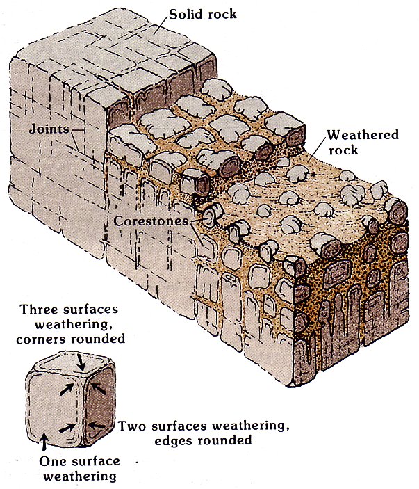
Residual rock forms occur at the top of a residual hill (398 m a.s.l.) at the SW limit of the Žulovská pahorkatina. The castellated rocks, rock walls, and tors in medium-grained biotite granodiorite with microforms on their surfaces are rather isolated and well-rounded (Fig. 21.10). The absence of debris or extensive blockfields suggests their etched origin according to a two-phase evolution model, which consists of a period of differential weathering followed by regolith stripping, rather than origin due to frost-shattering in periglacial environment. Thus, here the tors represent corestones exposed from saprolite. Instructive example of corestones can be also found on the NW slope of the Sokolský hřbet (Fig. 21.11).

Residual rock landforms composed of granodiorite in the Žulovská pahorkatina a Tors and rock walls with weathering microforms to the N of Jestřábí vrch, b weathering pits and tafoni located on the top tor on inselberg Píšťala, c isolated precariously balanced rocks on the slope of inselberg Borový vrch, d tors on the slope of Borový vrch, e rock slabs on the SW slope of Borový vrch, f rockwall with pseudokarren and weathering pit on the SW slope of inselberg Smolný vrch, g weathering pit on Smolný vrch (Photo P. Štěpančíková)

a Stages of boulder development by differential joint-controlled subsurface weathering and spheroidal disintegration of granites followed by removal of debris (modified after http://www.yosemite.ca.us/library/geologic_story_of_yosemite/images/43.jpg), b initial phase of corestone exposure; rounded shapes contrast sharply with the paragneiss overlaying the granite (top right hand-side), c the corestone with onion-skin weathering. The quarry is located near Mt Zelená hora in the Sokolský hřbet , see Fig. 21.1 (Photo P. Štěpančíková)
Inselbergs Píšťala (447 m a.s.l.), Borový vrch and Smolný vrch host various rock forms: tors with abundant microforms such as weathering pits, often connected by draining channels, tafoni , pseudokarren , honeycombs , rock cavities , etc. Moreover, Borový vrch is famous for tors on the slopes and isolated rock slabs, and Smolný vrch for its weathering pits , which were considered as artefacts in sites of pagan sacrificial rituals and called “Venus bowls ” (Fig. 21.10). A group of tors occurs also to the SE of Kaní hora Mt in fine-grained biotite granodiorite, where open joints control their shape. Rock fragments with differing lithologies such as metagabbro, quartz, and quartz diorite were found deep inside these joints. This suggests that these fragments have been transported by the continental glacier , thus the tors are of pre-glacial origin (Štěpančíková and Rowberry 2008).
6.2 Karst Caves
Karst in the Rychlebské hory is formed in Devonian crystalline limestone . During the Middle Pleistocene the continental glacier and climatic cooling affected the area and significantly influenced cave development in the area.
One of the most attractive caves in the area is Na Špičáku cave (Fig. 21.2). The cave is formed under the Velký Špičák hill (482 m a.s.l.), with marble castellated rocks controlled by tectonics. The cave was modelled by meltwater from the Middle Pleistocene (Elsterian 2?) continental ice-sheet that shaped the corridors into distinctive heart-shaped cross-section, which are typical for this cave. This origin and cave modelling occur quite rarely in central Europe. Beside Na Špičáku cave we can find it also in the Staré Podhradí cave, which is formed within the contact of marble and granite (Fig. 21.12) (Král 1958). Moreover, Na Špičáku cave is the oldest mentioned cave in central Europe, noticed by Anthonius Wale in 1430. The cave provided a hiding place from the Middle Ages , which is evidenced by four thousands of epigraphic inscriptions on the walls, the oldest one being from 1519. Not far from the cave, near Supíkovice town, relicts of typical tropical tower karst “mogotes” were excavated from fluvioglacial deposits. Depressions among karst towers are filled by reddish kaoline-rich clay and sandy deposits. The karst towers can be compared to granite inselbergs in the Žulovská pahorkatina, which were formed during the same Paleogene periods typified by tropical climate (Czudek and Demek 1960).

Caves modelled by glacier meltwater , which resulted in sub-horizontal corridors: a heart-shaped corridor in the Na Špičáku cave with epigraphic inscriptions on the wall (top left corner), b Staré Podhradí cave formed within the contact of marble and granite. For location see Fig. 21.2 (Photo P. Štěpančíková)
The touristic Na Pomezí caves are the longest and most extensive karst system formed in crystalline limestones in the Czech Republic. The high chemical purity of the limestone, favourable bedding dip with several variably oriented systems of fissures and faults were the primary controlling factors of cave development. The Quaternary cave evolution was also influenced by cooling and the presence of the ice-sheet in the immediate proximity, when the limestone massif was modelled by periglacial processes . It was torn by ice in cracks up to a depth of 20 m. Seeping water widened the fissures by its corrosive and erosive effects resulting in a system of joined corridors (Král 1958). The cave system has been partly known from as early as 1936, but it was only in 1949 when the caves were fully explored. Typical for the Na Pomezí caves are cascades and large stalactites, one of them being shaped and known as “a heart”.
7 Social and Economic Value of Unique Geological Variability
7.1 Times of Prosperous Mining
The area of the Rychlebské hory, Žulovská pahorkatina and the surrounding area have abundant mineral resources (Fig. 21.2), which have brought economic benefit to the region since medieval times. A number of deposits of metal ore could be found here such as gold , silver , copper , lead , zinc , iron ore , arsenic ore, formations of bismuth-cobalt-nickel-uranium ore, molybdenum and wolfram. Mines and quarries for graphite, kaoline, clays, quartz, peat and especially for crystalline limestone and granite were opened. Deposits of sand and gravel were also quarried. Mining of iron ore and non-ferrous metals was carried out with slight fluctuations since the beginning of the settlement, mainly from the sixteenth to nineteenth century. During the nineteenth century and the first half of the twentieth century there was stagnation of ore mining, which resulted in its gradual disappearance. The only exception was mining of uranium and associated ores in the second half of the twentieth century near Zálesí village (Skácel 2006). During the nineteenth century high-quality marble was discovered near Supíkovice and Velké Kunětice villages. It was quarried for lime burning, but mainly as a decorative stone for statues, decorative elements of buildings, monuments, etc. Beautiful marble products that come from this region have become a part of many important European buildings (e.g. Pergamon Museum in Berlin). That is the reason why Supíkovice village is also called “Silesian Cararra ”.
Names of several villages, places or peaks that evidence mineral resources, remain a curiosity of the region. We can find the village of Vápenná (“Limestone village”), Žulová (“Granitic town”), Písečná (“Sand village”), Uhelná (“Coal village”), Zlaté hory (“Golden mountains town”), peaks of Stříbrník (“Silver hill”), Vápenný vrch (“Lime Hill”), Žulový vrch (“Granitic Hill”), Čedičový vrch (“Basalt hill”), etc.
7.2 Priessnitz Spa : Birthplace of Famous Hydrotherapy
The Rychlebské hory were also a home of a peasant, Vincent Priessnitz (1799–1851), who was born in the village of Gräfenberg (recently Lázně Jeseník Spa , Fig. 21.1), in former Austrian Silesia. Despite not being a doctor, he became wold famous for pioneering modern hydrotherapy . When he was 16-years old he sustained injury during an accident when a horse carriage run over his chest and Priessnitz received numerous bruises and rib fractures. Local healer gave him no hope of recovery, but Priessnitz tried cold water as the same remedy he used in the treatment of the domestic animals for which he cared. He was completely cured in a short time. As the news on this remarkable cure without using any drugs or lotions spread, many wounded and chronically ill persons came to him for relief. Priessnitz was soon fully occupied with their treatment. He was not a quack; he worked honestly and openly, and was earnestly and sagaciously developing the great principles which he recognized. His cure based on perspiration followed by cold applications, using cold mountain spring water, outdoor exercise and manual labour, had great success. Although his methods seemed to be crude he helped to recover a great number of chronic invalids whose affections were practically incurable by the medical methods common those days. No wonder that he drew general attention to the previously little appreciated importance of applying water as a remedial agent used in various simple methods. Despite original scepticism of scientific physicians the Austrian emperor granted him a diploma and gold medal after an official investigation of his work and methods. The French government sent the head of the army medical department to study his methods, so the hydrotherapy was introduced into the French military service, later also to other countries and promptly disseminated (Kellogg 1910). In 1822 Vincenz Priessnitz founded the first hydrotherapy institute in the world. He built also a house for accommodation of patients in Gräfenberk, which is now the Museum of Vincenz Priessnitz, attracting a number of tourists. Progressive expansion of the spa influenced the development of the poor mountainous village and its surroundings, so it became a sought-after balneal place also for rich and noble clientele such as archduke Franz Karl, writer Nikolai Gogol, sculptor Hermann Bissen, physicians Elisabeth Blackwell, Sir Charles Scudamore, etc. During history the spa resort experienced different transformations reflecting also the world events such as wars. At the end of the nineteenth century hydrotherapy became a great fashion and the reputation of Gräfenberk spa continuously rose. In the present-day the Priessnitz Medical Spa plc serves as a prominent climatic spa with tens of cold water springs, which yearly attracts more than 10,000 patients by its health benefits as well as by its emplacement in the middle of gorgeous mountains. In 1999, the 200th anniversary of Vincenz Priessnitz´s birth was included in the UNESCO list of world´s cultural anniversaries (Kočka and Kubík 2006).
8 Conclusion
The area of the Rychlebské hory (Mountains) and Žulovská pahorkatina (Hilly Land) provides striking landscape diversity, which is a result of a long polygenetic history within the area. Due to different tectonic evolution of both morphostructural units related to faulting along the Sudetic Marginal Fault, which is one of the morphologically most pronounced features in the Bohemian Massif, diverse relief has been formed. The Rychlebské hory have been uplifted mainly during late Cenozoicand their relief rejuvenated by increased river incision. They sharply contrast with the Žulovská pahorkatina composed of granitoids, which represents one of the most remarkable parts of the Bohemian Massif with its gently undulated surface with numerous inselbergs, exposed irregularities of the stripped basal weathering surface, and granite rock forms , which remind a subtropical or tropical relief. Post-glacial (post-Saalian 1–240,000 years) uplift of the region related most probably to glacioisostatic rebound resulted in removal of most of remaining weathering products and Quaternary deposits, and in river valley deepening.
Due to diversified lithology, numerous quarries and sand pits are spread over the area, some of the abandoned ones used for water recreation. Except for quarrying the mostly forested area has never been affected by any industry and with its unique landscape, clean and untouched nature, and remote position, it is a sought-after place by those who prefer calm ambient to relax or do sports or even to heal in the local climatic Priessnitz Spa with long and unique history.
References
Badura J, Przybylski B, Zuchiewicz W (2004) Cainozoic evolution of Lower Silesia, SW Poland: a new interpretation in the light of sub-Cainozoic and sub-Quaternary topography. Acta Geodyn Geomater 1 3(135):7–29
Badura J, Zuchiewicz W, Štěpančíková P, Przybylski B, Kontny B, Cacoń S (2007) The Sudetic Marginal Fault: a young morphotectonic feature at the NE margin of the Bohemian Massif, Central Europe. Acta Geodyn Geomater 4 4(148):1–23
Cwojdziński S, Żelaźniewicz A (1995) Podłoże krystaliczne bloku przedsudec-kiego. Geologia i ochrona środowiska bloku przedsudeckiego. Przew. 66 Zjazdu PTG, 11–28
Czudek T, Demek J (1960) Formy fosilního krasovění v podloží glaciálních usazenin u Supíkovic ve Slezsku. Přírodovědný časopis slezský 21:588–591
Demek J (1976) Pleistocene continental glaciation and its effects on the relief of the northeastern part of the Bohemian Highlands. Studia Societatis Scientiarium Torunensis 8. Sectio C (Geographica et Geologia) 4–6:63–74
Demek J, Marvan P, Panoš V, Raušer J (1964) Formy zvětrávání a odnosu žuly a jejich závislost na podnebí. Rozpravy ČSAV, řada mat.-přír. 74 9:1–59
Ivan A (1983) Geomorfologické poměry Žulovské pahorkatiny. Zprávy GgÚ ČSAV 20(4):49–69
Kellogg JH (1910) Rational hydrotherapy: a manual of the physiological and therapeutic effects of hydriatic procedures, and the technique of their application in the treatment of disease. 4th rev. ed., F. A. Davis company, Philadelphia, 21–1247
Kočka M, Kubík A (2006) Vincenz Priessnitz: Světový přírodní léčitel. 1. vyd. Pavel Ševčík – Veduta, Štíty, 183 pp
Král V (1958) Kras a jeskyně Východních Sudet. Acta Universitatis Carolinae. Geologica 2:159 pp
Krzyszkowski D, Pijet E (1993) Morphological effects of Pleistocene fault activity in the Sowie Mts., southwestern Poland. Zeitschr. Geomorph. N. F. Suppl.-Bd. 94:243–259
Migoń P (1993) Geomorphological characteristics of mature fault-generated range fronts, Sudetes Mts., Southwestern Poland. Zeitschr. Geomorph. N. F. Suppl.-Bd. 94:223–241
Migoń P (1997) Crystalline Rock Inselbergs in Southwestern Poland, Origin and Paleoenvironmental Significance. Studia Geograficzne LXVI, Wyd, Uniw. Wrocl 102 p
Milický V, Kabát F, Křelina B (1985) Kaolín z Vidnavy a jeho tradiční využití. Sbor. geol. věd. Technologie, geochemie 20:203–232
Paleček M, Pospíšil V, Hanžl P, Krejčí Z (2013) Mapová aplikace geologická mapa 1 : 50 000. Praha. http://mapy.geology.cz/geocr_50/
Peška P (1992) Stress indications in the Bohemian Massif: reinterpretation of the borehole televiewer data. Stud Geophys Geod 4:307–324
Skácel J (2006) Historický pohled na poznávání a těžbu zdrojů nerostných surovin na Jesenicku. VI. Svatováclavské česko-polsko-německé setkání v Jeseníku, sborník referátů, Vlastivědné muzeum Jeseník, pp 9–30
Sponheuer W (1952) Erdbebenkatalog Deutschlands und der angrenzenden Gebiete für die Jahre 1800 bis 1899. Akademie-Verlag GmbH, Berlin 195 p
Štěpančíková P, Rockwell T, Hartvich F, Tábořík P, Stemberk J, Ortuňo M, Wechsler N (2013) Late Quaternary Activity of the Sudetic Marginal Fault in the Czech Republic: A signal of Ice Loading? In: C. Grutzner, A. Rudersdorf, R. Peréz-Lopéz, K. Reicherter, eds.: Seismic Hazard, Critical Facilities and Slow Active Faults. 4th International INQUA Meeting on Paleoseismology, Active tectonics and Archeoseismology, Aachen, Germany, pp 259–262
Štěpančíková P, Rowberry M (2008) Rock landforms that reflect differential relief development in the north-eastern sector of the Rychlebské hory and the adjacent area of Žulovská pahorkatina (SE Sudeten Mts, Czech Republic). Acta Geodyn Geomater 5 3(151):297–321
Štěpančíková P, Stemberk J, Vilímek V, Košťák B (2008) Neotectonic development of drainage networks in the East Sudeten Mountains and monitoring of recent fault displacements (Czech Republic). Geomorphology 102(1):68–80
Vídeňský A, Nývlt D, Štěpančíková P (2007) Příspěvek k otázce vzniku granitoidních elevací v západní části Černovodské pahorkatiny, žulovský batolit. Geol Výzk Mor Slez v r 2006:35–39
Žáček V, Čurda J, Kočandrle J, Nekovařík Č, Nývlt D, Pecina V, Skácelová D, Skácelová Z, Večeřa J (2004) Základní geologická mapa České republiky 1:25 000 s Vysvětlivkami, 14-222 Vidnava. Česká geologická služba, Praha 46 p
Acknowledgments
The long-term research in the area was supported by the Czech Science Foundation projects No. 205/08/P521 and No. P210/12/0573, Czech Ministry of Education, Youth and Sports project No. LH12078, and grant foundation of Charles University GAUK 862213. This work was carried out also thanks to the support of the long-term conceptual development research organisation RVO: 67985891.
Author information
Authors and Affiliations
Corresponding author
Editor information
Editors and Affiliations
Rights and permissions
Copyright information
© 2016 Springer International Publishing Switzerland
About this chapter
Cite this chapter
Štěpančíková, P., Stemberk, J. (2016). Region of the Rychlebské Hory Mountains—Tectonically Controlled Landforms and Unique Landscape of Granite Inselbergs (Sudetic Mountains). In: Pánek, T., Hradecký, J. (eds) Landscapes and Landforms of the Czech Republic. World Geomorphological Landscapes. Springer, Cham. https://doi.org/10.1007/978-3-319-27537-6_21
Download citation
DOI: https://doi.org/10.1007/978-3-319-27537-6_21
Published:
Publisher Name: Springer, Cham
Print ISBN: 978-3-319-27536-9
Online ISBN: 978-3-319-27537-6
eBook Packages: Earth and Environmental ScienceEarth and Environmental Science (R0)