
Abstract
The evolution of the Swiss landscape during the Quaternary Period over the past 2.6 million years is controlled by multiple glaciations and deglaciations with at least 15 drastic environmental changes between glacier advances (with yearly average temperatures of –16° compared with today) and warm phases (with yearly average temperatures of +2° compared with today). During the Most Extensive Glaciation (MEG) several hundred thousand years ago, Switzerland was almost completely ice-covered with the exception of the area around Basel and the most external parts of the Jura Mountains . During the warmest interglacial periods the glaciers were, most likely, completely gone. The feeding mechanism for the inner-alpine ice accumulation was a southerly (foehn) circulation. Vegetation cover during interglacials was comparable to today except for the Last Interglacial when Fagus (beech) was missing and during at least one older interglacial when a Fagus/Petrocary-forest was growing in the Central Plateau. The age for the deep valley erosion in the northern Alpine Foreland is several millions of years younger than in southern Alpine Insubria.
Access provided by Autonomous University of Puebla. Download chapter PDF
Keywords
1 Introduction
The evolution of the Swiss landscape during the Quaternary Period over the past 2.6 million years is controlled by multiple glaciations (e.g., Fig. 4.1) and deglaciations with at least 15 drastic environmental changes between glacier advances, with yearly average temperatures as low as –16° compared with today; and warm phases, with yearly average temperatures of +2° compared with today. After discussing dating issues and the question of long sedimentary records, this chapter presents the main glaciations and interglacials and their legacy.

The extent of the Last Glacial Maximum (LGM) in Switzerland with locations of key sites referred to in the text: MG = Mont Miné Glacier, S = Simplonpass, G = Grimselpass, F = Furkapass, O = Oberalppass, J = Julierpass, A = Grosser Aletschgletscher , B = Brünigpass, SH = Sieben Hengste, NW = Niederweningen, W = Nordalpines Wasserschloss (confluence of Aare, Reuss and Limmat rivers) , LW = Lake of Walenstadt, WH = Wildhaus, N = Napf, Hö = Hörnli, MF = Melchsee-Frutt, HR = Hasle-Rüegsau, Emme = Emme River
This chapter is neither considered to be a review focusing on the history of research on the paleoglaciations or on the evolution of Quaternary sciences in Switzerland, nor a fundamental discussion on the validity of the classical Quaternary stratigraphy of the Alpine Forelands by Penck and Brückner (1909). There is nothing wrong with using the term “Würmian” for the last glaciation. However, going further back in time, correlations and chronostratigraphic orders are more complex and mostly unsolved. An initiative to solve some of these issues has been taken by the Federal Office of Topography swisstopo for the unification of the legend of the Geological Atlas of Switzerland. This initiative, called HARMOS (Strasky et al. 2016), is summarized in Fig. 4.2.

Note the table is in national languages (German, Italian) to show the comparison between different terms used
HARMOS: the pragmatic approach to the Quaternary stratigraphic system of Switzerland by swisstopo.
Throughout the chapter, radiocarbon dates are given as uncalibrated calculations as given by the laboratories.
2 The Dating Issues
Advances in knowledge on the Quaternary Period in Switzerland is directly related to the progress in physical and physico-chemical dating of different geological products and to the availability of large outcrops and, therefore, long sedimentary records.
The classical dating approach has been by comparative morphostratigraphy, as it has been ingeniously elaborated by Penck and Brückner (1909) who referred to defined levels of aggradational terraces as time and event markers, and by mapping soil depth (Conradin 1991). These methods are still part of the Quaternary stratigraphy repertoire (Mailänder and Veit 2001) and applicable, if appropriately evaluated.
Absolute, radiometric dating started to be an important contribution after the mid-1960s with the establishment of a radiocarbon laboratory at the University in Bern by Hans Oeschger. Today, this method is fully developed and at the core of radiometric dating of Quaternary age organic material (Hajdas 2008). The methodological refinement of the method to work with small samples is the key to many chrono- and ecostratigraphic uncertainties of the past ca. 30 ka (Hajdas 2008).
It is only in the early 1990s that a method, developed in meteorite research, emerged and became the counterpart of radiocarbon dating in terrestrial Quaternary chronology: cosmogenic nuclide dating of non-organic geomorphological surfaces (Ivy-Ochs 1996). This method allowed an old dream in geosciences to become true: to determine not only the age of the rock as a material but of a rock surface and thus of a landscape element as a morphological unit. The signal used is the measured concentration of a given “cosmogenic nuclide” in a sample. The following terrestrial cosmogenic nuclides are used: 3He, 10Be, 14C, 21Ne, 26Al, 36Cl, and, rarely, 54Mn. The standard application is the dating of a rock surface, i.e., to measure the length of time elapsed since a specific rock surface at a specific place has been formed (e.g., the resting time of an erratic boulder at a stable place). This application is called surface exposure dating. A promising new trend in the application of cosmogenic nuclides is depth profile dating of a vertical sediment column and isochrone burial dating of well-defined beds in an aggradational sequence (Dehnert and Schlüchter 2008). Of challenging interest is still the combination of both, strict burial and isochrone burial dating, ideally applied to the dating of terraces. Terrestrial cosmogenic nuclide methodology has moved Quaternary geochronology from painting the landscape in a still more or less open timeframe to a quantitative geochronological system.
The method of luminescence dating with all more advanced stimulating techniques, e.g., thermo-, optical-, infrared-, laser-stimulation, is operating at a high, but still experimental stage. Additional isotope-based standard dating techniques, e.g., K/Ar on selected minerals, are not commonly used in Switzerland because appropriate material is lacking (e.g., volcanic ash). For young sediments (<100 years), 137Cs has been successfully used on several occasions (Blass et al. 2003; Gilli et al. 2003). Finally, paleomagnetic dating in Switzerland is restricted to very small time windows due to a lack of long, continuous, suitable sedimentary records. However, interesting secondary magnetic overprint has been detected in Deckenschotter accumulations (Graf 1993), which allowed the interpretation of minimum ages, and at Ecoteaux /VD,Footnote 1 where the Matuyama/Brunhes paleomagnetic boundary was detected (Pugin et al. 1993).
Biostratigraphy, namely palynostratigraphy, is an important contribution to put sections into evolutionary frameworks of vegetation and in interpreted versions of ecology, climate, and time (Welten 1982, 1988; Ammann et al. 1994). Palynological records in combination with radiocarbon or paleomagnetic dating are indispensable for an understanding of succeeding colder/warmer or more specifically stadial/interstadial and glacial/interglacial windows in the history of the Quaternary Ice Age (Wegmüller 1992; Bezat 2000). It must be kept in mind that palynostratigraphy has been the unique approach for dating non-glacial sediment sequences in the absence of more varied dating methods at that time (Welten 1982, 1988; Wegmüller 1992; Bezat 2000; Drescher-Schneider et al. 2007).
A short list of internationally accepted reference time levels in the Quaternary Period is given in Table 4.1 (see also Figs. 4.3 and 4.4). These chronostratigraphic boundaries are valid for Switzerland. Some are even locally constrained (e.g., 11.7, 115 ka).

(from Litt et al. 2008)
The Alpine Quaternary history in a global context

Figure 4.4 gives a summary of the Quaternary stratigraphy of Switzerland, based on records and available dates from the northern Alpine Foreland. Comparison with the southern Alpine area is schematically shown and Fig. 4.3 gives an indication of likely links with the global oxygen isotope record. These comparisons are not ascertained correlations. They should stimulate discussion and further research. However, with more radiometric dates available now for the Deckenschotter (Swiss Cover Gravels, Fig. 4.3; Claude et al. 2013, 2017), the Early/Middle Pleistocene boundary is likely to be correct and being associated with the main morphotectonic event of the Middle Pleistocene Revolution (MPR). The term “Middle Pleistocene Revolution” is somehow misleading as it suggests one severe morphodynamic event only in the Early Middle Pleistocene. In reality, it represents a stepwise lowering of the erosive base level for the drainage in the northern Alpine Foreland or a stepwise uplift of the headwaters. The first step defines the end of deposition of the Höhere Deckenschotter (Akçar et al. 2014; Claude et al. 2017). The second step is marked by deep downcutting into the aggradation surfaces of the Tiefere Deckenschotter and makes it a prominent well-defined landscape element. The complex morphological situations make it likely that this second step consisted of a series of smaller steps as well. The Most Extensive Glaciation (MEG, which may not have been the Most Voluminous Glaciation, MVG) is placed in the present chronological framework just following the deepest erosion of the valleys in the Swiss Midlands and, in this way time-like related to the most severe erosion (Figs. 4.3 and 4.4). By far the largest volume of sediments in these deeply eroded valleys is of glaciolacustrine facies (e.g., waterlain tills). Despite the fact that the age of the MEG is still under debate and that its relationship to the Deckenschotter glaciations still needs to be worked out, there is no doubt that it did exist. The red bars in Fig. 4.4 are not fake news; however, they will need to be adjusted in the future.
3 Large Outcrops and Long Sedimentary Records
The construction boom of the late 1960s and early 1970s opened up large and deep windows into the Quaternary sediments and, suddenly, the hidden interior of the Ice Age landscapes became visible, measurable, and accessible to analysis. Before that time, the largest outcrops were along deeply incised rivers as was the case of the rivers Dranse (south of Lake Geneva , Haute-Savoie, France), Kander (west of Thun, artificially initiated), Lorze (area of Zug) (see location in Fig. 4.1) and a great number of relatively small extraction sites of gravel for local use. The new large outcrops were and are mainly gravel pits, with sections hundreds of meters long and tens of meters of vertical extension. Unfortunately for Quaternary research, most of these outcrops are subject to environmental protection policy and have to be re-naturalized, which means refilling and re-greening after the end of extraction. Therefore, archives of former photograph coverage and of selected samples become important. In many cantons, some outcrops are supplemented by extensive drilling projects in the context of groundwater studies and management policies. Over the past 40 years, Quaternary research in Switzerland became, therefore, 3D research.
One of the most striking and unexpected results was the discovery of hidden paleolandscapes covered by more recent deposits. The Quaternary paleorelief predating the last glaciation was as accentuated as the present-day landscape (e.g., Thalgut/BE , Fig. 4.5, and Buchberg/SZ). A number of specifically planned or extended drillings carried out within research projects produced important results, in particular, in Kiesen/Rotachewald/BE (Schlüchter 1984), Thalgut/BE (Welten 1982, 1988; Schlüchter 1989) , Meikirch/BE (Welten 1982, 1988; Preusser et al. 2005), Grandson/VD (Welten 1988), Zübo/Lake Zürich/ZH (Hsü and Kelts 1984), Buchberg/SZ (Welten 1988), Gondiswil-Zell/BE-LU (Wegmüller 1992), Ecoteaux /VD (Pugin et al. 1993; Bezat 2000) and the Seeztal/SG-GR, between Lake of Walenstadt and Sargans (Müller 1995) (see location in Fig. 4.1). The two most important results of these drillings were (i) the discovery of superimposed interglacial deposits with different paleovegetation signals and (ii) the lithostratigraphic discrepancy between records in the main thalwegs of the valleys and those in higher lateral (terrace) positions.

(photos C. Schlüchter 1991)
Gravel pit at Thalgut/BE . a General view of the “core of the section”, with major unconformity in the central part of the picture and with the drilling rig; b detail view of the major unconformity
4 Large Quaternary Landscapes in Switzerland
A striking contrast in the Quaternary landscape in Switzerland is between the soft and smoothened areas covered by the glaciers of the Last Glacial Maximum (LGM) and the external areas where vertical erosion processes dominated, like the prominent examples of landscapes sculptured by fluvial processes of the Napf and the Hörnli (Fig. 4.1) or the high-mountain landscapes above the trimline, where mechanical weathering dominated (e.g., Grimsel, Fig. 4.6) . The reconstruction of the ice cover in the Central Alps , e.g., for the LGM (Fig. 4.1), relies on the spectacular trimlines in the crystalline rocks of the central massifs which delineate the maximum elevation of actively moving ice (Fig. 4.6). A magnificent example of a landscape in the Molasse bedrock, partially drowned by more recent accumulations (here of the LGM) is the “crest and earth pillar” morphology at Krauchthal/BE (Lauber 2003, Fig. 4.7).

(photo C. Schlüchter 2017)
The trimline in the Central Alps : Vorder Zinggenstock near Grimselpass, with spectacular roches moutonnées landscape

(photo C. Schlüchter 2003)
An example of landforms beyond the limit of LGM glaciers: rock spires at Krauchthal/BE
Important landscape elements, however, neither visible nor directly accessible, are deeply eroded valleys of the Alpine Foreland (e.g., Dürst Stucki et al. 2010; Dehnert et al. 2012; Ivy-Ochs et al., this volume) and of the inner-Alpine areas, with the most important examples of the Insubric (=the morphological transition between the southern border of the Alps and the Po Plain in Italy) valleys and lakes, south of the Alps , where bedrock lies as deep as more than 600 m below the present level of the Adriatic sea (Finckh 1978; Finckh et al. 1984). The age of the deepest erosion is not, necessarily, the same in the Insubric area, where it most likely goes back to the Messinian salinity crisis in the Mediterranean, 5–7 million years ago (see Scapozza and Ambrosi, this volume), and in the northern Alpine Foreland, where it is related to the Middle Pleistocene Events (MPE) or Revolution (MPR). A revolution is usually a multi-step event, also in geology. The deep incision of the main valleys into bedrock is, therefore, about 6 million years younger to the north of the Alps than to the south.
Some areas are first-order Quaternary landscapes as they control the contemporary (and did control in the past) landscape evolution:
-
(1)
The mesa-type landscape of the Deckenschotter in northeastern/northern Switzerland (see Keller, this volume) connects to the classical “Eiszeitlandschaft” (Ice age landscape) in Southern Germany. The Swiss Deckenschotter sector is part of the same (paleo) tectonic area, of the so-called “Süddeutsche Grossscholle.” This landscape has no equivalent neither in the central nor in the western sector of the Swiss Midlands .
-
(2)
The position of the sub-Jurassic lakes (Neuchâtel, Murten, and Biel) is delicately arranged in the tectonic structures parallel to the structural elements of the Jura Mountains (Gorin et al. 2003) and most likely related to subrecent subsidence of the western part of the Swiss Midlands and of the Lake Geneva Basin .
-
(3)
The drainage of the Swiss Midlands is directly connected to the southern front of the Jura Mountains , where the River Aare cuts through the Born anticline (Fig. 4.1). River downcutting in the Midlands is obviously balanced by uplift of the Jura. This situation is repeated further to the east, where the merged waters of the Aare, Reuss, and (Linth-) Limmat rivers cut the entire folded and tabular Jura Mountains to reach the southern border of the Black Forest Massif (“nordalpines Wasserschloss,” northern Alpine water tower) to join the Rhine drainage system.
5 Glaciations
Two questions are of concern: (i) When did the first glaciers develop in the Alpine region at the onset of the ongoing Ice Age (Fig. 4.3) and (ii) When did the last glaciation end? The answer to the first question is complex and difficult; the answer to the second question is rather straightforward (Figs. 4.2 and 4.3).
5.1 The First Glaciation(s)
The first glaciation(s) in the Insubric area are recorded in sections in the Valle della Fornace (Fig. 4.1) in the Swiss/Italian border area. The lower part of the section contains brackish to lacustrine sediments and voluminous delta deposits (Formazione della Valle della Fornace (Valle della Fornace Formation); Uggeri et al. 1997) as an infill of one of the deep Messinian Insubric valleys. The Valle della Fornace Formation is grading upward into glaciolacustrine facies (Vivirolo Formation). Below the accessible outcrops in the valley are marine clays (Argille di Castel di Sotto) recorded in drill cores. They are attributed, through pollen analyses, to the Middle Pliocene, which puts the overlying Formazione della Valle della Fornace to the Upper Pliocene (Uggeri et al. 1997; Martinetto and Ravazzi 1997). However, this chronostratigraphic positioning was inferred under the philosophy of the previously fixed Pliocene/Pleistocene boundary at 1.65 ma, without radiometric dating at this specific site. By adjusting the Pliocene/Pleistocene boundary to 2.588 ma, following recent research, the Valle della Fornace Formation and, mainly, the Vivirolo Formation are considered to be part of the Pleistocene series. The glaciolacustrine sediments of the Vivirolo Formation, therefore, document of the onset of glaciation in the Insubric area of the Alps in the early Pleistocene (>2 ma). Martinetto and Ravazzi (1997) classified some of the sediments of the Vivirolo Formation as tills; a glacier was obviously there at that time.
The discussion about the earliest glaciation in the northern Alpine Foreland concentrates on facies interpretation of the Deckenschotter (Cover gravel) sequences of northern Switzerland. These coarse gravel aggradations rest unconformably on the Cenozoic (Molasse) or Mesozoic bedrock and contain in their oldest units at Irchel/ZH or Stadlerberg/ZH boulders of Alpine provenance and proximal fluvioglacial sandy-silty gravel, which asks for a near-glacier facies (Graf 1993, 2009). The minimum chronostratigraphic position of the oldest units of Deckenschotter is given by the mammal findings at Irchel-Steig, which belong to the Neogene Mammalian Stage NM 17 (Bolliger et al. 1996). The precise chronostratigraphic position of the Pliocene/Pleistocene boundary is of direct relevance here, as it makes the oldest unit of Deckenschotter , older than 2 ma. Ongoing dating efforts by using cosmogenic nuclides confirm that the oldest Ice Age deposits here are older than 2 ma (Akçar et al. 2014; Claude et al. 2017).
The current level of knowledge allows one for the safe assumption that the first glaciation of the Quaternary Ice Age did occur more than 2 ma ago in the Alps and that it did produce glacial sediment facies associations in both the northern and the southern Alpine Forelands. However, the pre-glacial landscape in the north was different from that in the south. In the north, broad valleys existed beyond the border of the Alps and far-reaching piedmont aggradational fans were fed by the advancing glaciers. In the Insubric area to the south of the Alps , the glaciers were confined to the much narrower, steeper, and deeper valleys of the Messinian fjords. This N-S asymmetry has consequences in the visibility of landscape elements today. In the north, the Deckenschotter landscape is characterized by mesa-type hills more than 150 m above the present valleys. It is a typical erosional relict of the Ice Age landscape, survived after a major phase of relief inversion and, most likely, of stepwise uplift and, as a consequence, stepwise incision. In the south, the records of the early glaciations are buried below younger sediments in deep valleys, with the exception of the brackish clays at Balerna/TI, a sedimentary unit of the post-Messinian high stand of the Adriatic sea. The question about the pre-glacial landscape and, more specifically, about perialpine lakes, as they exist today, remains largely open for the time being. Large slabs of highly compacted lacustrine deposits, including compressed peat, occur occasionally like erratic boulders in delta deposits of the Most Extensive Glaciation (e.g., Thalgut/BE) . The original position of these old lake sediments as well as their age is not known. However, they exist somewhere along the border of the Alps where the sediment slabs were picked up by an advancing glacier later. The only areas where speculations on the pre-glacial landscape are possible are the base levels of the Deckenschotter . There, it looks like a weakly structured, slightly inclined erosional landscape on Molasse sandstone or Mesozoic limestone.
Old landscape elements are reported by Gnägi and Schlüchter (2012) in the Berner Oberland (at Sieben Hengste/BE and at Stockhorn/BE) in the form of relict coarse gravel lenses within weathered slope deposits, containing indicator lithologies from the Penninic part of the Alps . They may be of fluvioglacial origin. However, the glacial component is not ascertained and they are, most likely, relict sediments in an unroofed cave . Silty gravel with erratic boulders were mapped at the surface and within the deposit on Piz Starlex at 3100 m in the Val Müstair/GR (not represented in Fig. 4.1) by Kocher (2012). The petrographic composition of the boulders and of the coarse gravel fraction is unique and points to east–west transport which required substantial changes in the drainage pattern of the Eastern Alps in the Early Pleistocene.
5.2 The Last Glaciation
The last glaciation has not been a uniform and permanently cold period for 100,000 years. However, it was initiated by a severe short-term cooling event (see “Interglacials and Interstadials” section). The comparison with the global oxygen isotope stratigraphy (Fig. 4.8a) is ascertained to an acceptable level for the time window of the last glacial cycle (Figs. 4.2, 4.3, and 4.8b). The climate pattern behind the evolution of the oxygen isotope composition of the atmosphere is supported by stratigraphy, despite the fact that first-order correlations are missing. After the first cold spell of the Marine Oxygen Isotope Stage (MIS) 5d, a long and complex, oscillating climate pattern occurred, which is difficult to characterize using lithostratigraphy (Fig. 4.8b). This is possible only through pollen records, e.g., at Gossau/ZH (Welten 1982; Burga and Wynistorf 1987) or at Gondiswil-Zell/BE-LU (Wegmüller 1992). In the voluminous gravel aggradations predating the final LGM advance there is evidence for two main fluvioglacial phases in Thalgut/BE and Jaberg/BE, Gossau/ZH, Buchberg/SZ, as well as in the Lake Geneva Basin (Arn 1984). The exact timing of the earlier advance phase is still open. There are chronological points, e.g., at Finsterhennen/BE (Preusser et al. 2011), at Gossau/ZH (Schlüchter et al. 1987), as well as along Lake of Walenstadt/SG (Schindler et al. 1985). The onset of the “final” advance, which produced the LGM-extent (Fig. 4.1), is sufficiently constrained. The Valais Paleoglacier reached the Midlands after 30 ka in the west as did the Rhine Paleoglacier in the east. For the Lyonnais Lobe of the “Valais Glacier” which is, in reality, the Arve Glacier, the final advance passed the border of the Alps not later than 25,470 years BP (Moscariello 1996, Schoeneich 1998); the same timing holds for the Swiss Lobe of the “Valais Glacier” , with 25,370 years BP for the Mammoth Tusk at Finsterhennen from the fluvioglacial aggradation below the basal till of the LGM . For the Linth Glacier the arrival time to the greater Zürich area is less than 28,550 years BP at Gossau/ZH and less than 28,060 years BP at Zürichberg. This last and main LGM advance to the Alpine Forelands is not an oscillation only out of an ice reservoir “just inside the border of the Alps .” Considerable areas in the high Alps must have remained ice-free before. This is documented by subfossil bear bones from caves in the Melchsee Frutt/OW area, with a radiocarbon age of about 33,000 years BP. It can be concluded that the LGM advance was a well-defined event, which started to develop in the higher inner-alpine valleys. This interpretation is supported by many sites containing organic sediments, with radiocarbon ages ranging between 30 ka and about 40 ka (e.g., van der Meer 1982, Wegmüller 1992, Hajdas 2008).

The reconstruction of the LGM glacier system in the Alps and its maximum position in the Alpine Forelands has been subject of active research in the recent years, with some far-reaching results (Schlüchter 2009; Luetscher et al. 2015; Becker et al. 2016, 2017): (i) moisture forming the inner-alpine ice masses was transported by southerly air flow (Foehn); (ii) this southerly moisture transport has been so important that accumulations were forming ice domes to the south of the main weather divide (Ice Dome Engiadina, Ice Dome Vorderrhein, Ice Dome Rhone, and the Ice Plateau Mattertal (Florineth and Schlüchter 1998, 2000; Kelly et al. 2004). This inner-alpine configuration has caused massive outflows to form the Valais Piedmont Glacier in the west and the Rhine Piedmont Glacier in the east (Fig. 4.1), with corresponding transport and distribution of erratic material in the forelands (Becker et al. 2017).
With maximum glacier extension to the western foreland a lake was dammed in the Emme Valley (Fig. 4.1). It was bound upvalley by a large fan complex. With the glacier recession the lake drained and the base level for the Emme River was lowered. As a consequence, the upvalley fan was dissected and extensive terraces formed. The final aggradation of the fan, and therefore the very maximum strength of the LGM ice dam, was radiocarbon dated at Hasle-Rüegsau/BE (Fig. 4.1). The most spectacular dated specimen is a humerus of the Woolly Rhino (Fig. 4.9), whose uncalibrated radiocarbon age is 17,448 ± 46 years BP (Laboratory reference ETH-55’673).

(photo Dr. A. Rehazek, Natural History Museum Bern)
Humerus of the Woolly Rhino from the gravel pit at Dicki/Emmental/BE
5.3 The End of the Last Glaciation
The end of the last glaciation is the most recent major environmental change, which fundamentally transformed the landscape: valleys and lakes formed and the topography became again very varied. The down-melt of the last large glaciers was an environmental catastrophe because the glaciers vanished fast. There are two striking pieces of evidence for this scenario: (i) radiocarbon dates on basal organic matter (macroremains, peat) in lakes and ponds which are synchronous within 1000 years in the northern and southern forelands and in the inner-alpine pass areas (Schlüchter 1988), and (ii) the “missing moraines” between the inner LGM ridges and the high valleys which is explained only by rapid, non-oscillating down-melt. Deglaciation from the LGM positions started as early as 24.0 ± 1.1 ka based on surface exposure dates on the erratic boulders at Steinhof/SO, which are part of the LGM system (Ivy-Ochs et al. 2004). Confirming dates on erratic boulders exist for the Reuss Glacier with 22.2 ± 1.0 ka (Reber et al. 2014) at Lenzburg/AG and for the Aare Glacier with 21.5 ± 1.0 ka in lateral positions at Möschberg/BE (Akçar et al. 2011). As early as 18 ka more than 80% of the LGM ice volume had disappeared (Ivy-Ochs et al. 2008), and the northern Alpine Foreland was already ice-free by that time (van Husen 1997; Hadorn et al. 2002; Keller and Krayss 2005). The same time range exists for the moraines of the “stade lémanique” in the Lake Geneva Basin (Arn 1984; Schoeneich 1998).
The glaciers disappeared by that time not only from the forelands but from long reaches of the alpine valleys as well (Ammann et al. 1994). This is inferred from the first reorganization of the back- and downwasting valley glaciers which occurred around 16–17 ka, producing the terminal moraine of the Gschnitz Stadial after a period of considerable retreat further upvalley before (Kerschner et al. 2002). The Gschnitz Stadial could be as old as 17.5 ka (Vescovi et al. 2007), relying on a number of surface exposure dates on boulders from the type locality morainic ridge in the Gschnitz valley in Austria, with a mean age of 16.7 ± 1.5 ka (Ivy-Ochs et al. 2006). The oscillations, formerly named Clavadel and Daun (Maisch 1987) and extensively correlated, are most likely not reflecting true and paleoclimatically important re-advances. The Alpine glaciers retreated way up into the cirque areas with reduced extensions comparable to the Little Ice Age already during the Bølling–Allerød warm interstadial period. The last major cold phase followed, with glaciers extending beyond the cirques to form the Egesen Moraine Complex . Surface exposure ages on boulders from the Egesen moraines at Julierpass/GR give ages of 12.0–13.5 ka for moraine stabilization (Ivy-Ochs et al. 2008). The spectacular lateral moraine systems of the Grosser Aletschgletscher /VS and Tortin in the high valley of Nendaz/VS (Scapozza 2015 and Fig. 4.10) confirm the Egesen advance in the western part of the Swiss Alps by 10Be-dates as well (Kelly et al. 2006; Schindelwig et al. 2011). The response of Grosser Aletschgletscher to the Egesen cooling resulted in a simple, however, voluminous lateral moraine (Kelly et al. 2006). Next to Grosser Aletschgletscher , a small cirque glacier at Belalp produced a delicate oscillative lateral moraine pattern during the Egesen Stadial (Schindelwig et al. 2011). Retreat from Egesen moraines started between 11.7 and 10.8 ka in the Grimsel area (Kelly et al. 2006; Wirsig et al. 2016). The Egesen moraines are most likely, as given by the surface exposure dates on boulder surfaces, the physical product of the Younger Dryas cold phase, which ended in the Greenland Ice Core Records at 11.5 ka. With the glaciers melting back from the Egesen moraines , the lateglacial phase of the last glaciation terminated in the high Alps .

(photo C. Schlüchter 2009)
The lateral moraine of the Egesen advance (i.e., morphological testimony of the Younger Dryas cold phase) in the upper valley of Nendaz/VS
5.4 The Holocene
The Holocene glacier record is based on two lines of evidence: (i) direct and simple moraine record as the physical–morphological product of glacier advances and (ii) more complete climate record of the past 11.5 ka based on subfossil trees and peat as evidence for glacier retreat in between the moraine ridges. Figure 4.11 summarizes the Holocene record, demonstrating the highly dynamic glacier response to climate forcing (Hormes et al. 2001; Holzhauser et al. 2005; Joerin et al. 2006; Goehring et al. 2011; Nicolussi and Schlüchter 2012). The most spectacular results are:

Summary table of Holocene Alpine glacier variations (after Joerin et al. 2006)
-
(1)
Confirmation of the 8.2 ka event at the Mont Miné Glacier/VS, linking directly and precisely the Greenland ice core to an alpine glacier record (Nicolussi and Schlüchter 2012). The 8.2 ka advance of the Mont Miné Glacier occurred suddenly after a several centuries long retreat phase.
-
(2)
The data from Rhone Glacier bedrock ridge (next to the Belvedere Hotel at Furkapass/VS) show pre-Little Ice Age exposure time of the local bedrock and thus demonstrate, in combination with data as shown in Fig. 4.11, reduced Holocene glacier expansion (compared to the 2005 position) for >50% of time since glacier retreat from the Egesen positions. A unique piece of evidence for reduced glaciers is found at Unteraargletscher, in the samples of compressed peat washed from underneath the actual glaciers by meltwater outbursts: a completely preserved wasp (Attractodes mesoleptus) in a peat fragment has been discovered (Schürch et al. 2015; Fig. 4.12).
Fig. 4.12 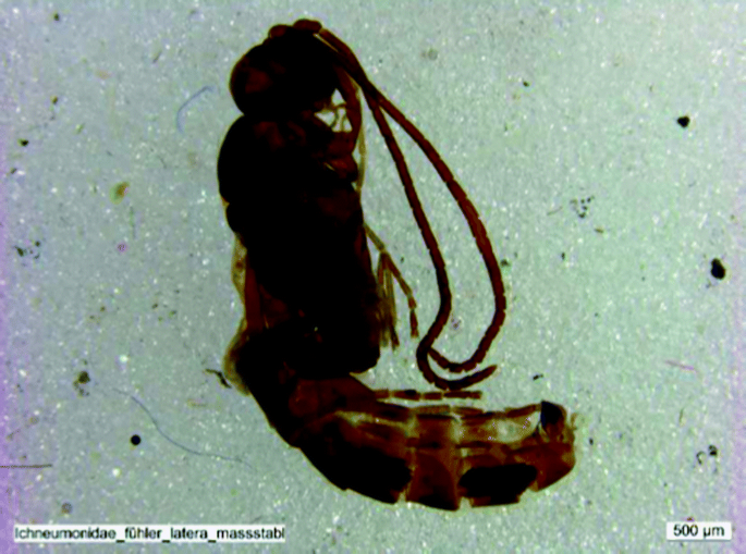
(from Schürch et al. 2015)
Subfossil wasp (Attractodes mesuleptus) from compressed subglacial peat, Unteraargletscher

5.5 Glaciations in-between and the Most Extensive Glaciation
The earliest and the last glaciations are the reference time-and-event-frames for the glaciations during the Quaternary (Figs. 4.2 and 4.3). The assemblage of available lithosequences allows for the reconstruction of a total of 15 different glacier advances over the past 2.6 ma for the northern Alpine Foreland, with a comparable complexity for the south (Bini 1997; Graf 2009). The two levels of Deckenschotter (Upper Deckenschotter and Lower Deckenschotter) contain lithostratigraphic units of at least eight glacier advances (Graf 1993) far beyond the border of the Alps . The upper (i.e., older) units are separated from the lower (i.e., younger) units by an important phase of incision (Fig. 4.13, Akçar et al. 2014). It is likely that this major incision occurred in the main phase of the MPR/MPE. The second revolutionary incision phase of the Middle Pleistocene Event is cutting down into the Lower Deckenschotter . Based on a few long records (e.g., Thalgut , Meikirch , Buechberg), the deepest erosion can roughly be related to the MEG (Fig. 4.3), which follows the incision phase of the Lower Deckenschotter , and which makes the Deckenschotter sequence older than the MEG (Figs. 4.2 and 4.3), i.e., older than 780 ka. Field evidence is excellent and shows glacial deposits often in complex lithological relationship between LGM and MEG ice extents, corresponding to at least three major glacier advances beyond the limits of LGM but not reaching the extent of MEG (=Complex of the Hochterrasse, Figs. 4.3 and 4.4). Erratic boulder evidence for the MEG is found in the Jura Mountains and comprises solitary boulders (Fig. 4.14, Graf 1993) and a hilly transverse-ridge dominated area in the valley of the Rhine River between Rheinfelden and Säckingen (=Möhlin Terminal Moraines , Dick et al. 1996; Gaar 2014). This area is traditionally considered the terminal area of the Most Extensive Alpine Glacier extent, which has been correlated with the Riss Glaciation of the classical glacier chronology of Southern Germany (Penck and Brückner 1909). As this Most Extensive Glaciation is, most likely, several hundred thousand years old, the term “Riss” needs re-definition: if the term is kept for the Most Extensive Glacier advance, then it names an event in the order of >780 ka. If the term is kept for the penultimate glaciation, then it stands for an event of less extent than the MEG . In such a classification dilemma it is recommended not to use the term “Riss” any longer until an unbiased definition is accepted. The mammoth finding site of Niederweningen/ZH is a key in this discussion (Welten 1988; Dehnert et al. 2012).

Schematic NW-SE cross section from Irchel to Klettgau and Rhine Valley. HDS = Höherer Deckenschotter, TDS = Tieferer Deckenschotter, HT = Hochterrasse (high terrace) and NT (Niederterrasse) multiphase aggradation complexes. A = incisions related to Middle Pleistocene Revolution (MPR) events; B = incisions related to the Most Extensive Glaciation (MEG) event(s). Stratigraphic relationships: oldest aggradation complex (HDS) is in highest morphostratigraphic position

(photo C. Schlüchter 2011)
Pre-LGM solitary crystalline erratic boulder at Vorberg/SO
Geometry and ice flow configurations of the Most Extensive Glaciation (MEG) need to be addressed as the relationship between the Möhlin Terminal Moraines and the Deckenschotter is not sorted out in detail. There are observations in the Möhlin area that ice from the Black Forest and not solely from the Alps has played a constructive role in the formation of the landscape (Dick et al. 1996). Optically stimulated luminescence (OSL) tests on loess-like sediments at Möhlin question the old age (Gaar 2014). In addition, lithostratigraphy of the Quaternary deposits contains a complex aggradation/paleosoil sequence representing at least two glaciations (Dick et al. 1996). This observation is of fundamental paleoclimatic importance, as it makes the MEG at least a two-phase event (Fig. 4.3).
Are there any more arguments to pin down the age of the MEG? If it is reasonable to assume that the till directly overlying bedrock in the deep valleys belongs genetically to the ice extent of the MEG far out to the foreland, then it belongs to a pre-MIS-11 event (e.g., Thalgut , Meikirch , Buechberg, see below “Interglacials and Interstadials” section). This age position goes in synchrony with advanced weathering and evolution of paleosoils, e.g., on Höhenschotter (Upper gravels) in the western Napf area or on tills in the external part of the Jura Mountains (Hildbrand 1990; Christen 1999; Schlüchter 2015). Direct dating of the vestiges of the MEG is still in progress. First sample sets for surface exposure dating of MEG erratic boulders did produce minimum ages of >100 ka and >150 ka, respectively (Graf et al. 2015). The uncertainties are as elsewhere: how stable were these boulders morphologically and how severe was the human impact, at least during and since Roman times.
6 Interglacials and Interstadials
Interglacials are periods when vegetation is characterized by the presence of broadleaf trees, jointly with Abies sp.; interstadials are periods when vegetation is characterized by grassland with limited tree growth (e.g., Betula, Salix). Fine-grained lacustrine deposits within complex lithostratigraphic successions with tills and coarse gravelly aggradations, typical for the Alpine area, are sediments with a realistic potential for detailed palynostratigraphic information. In the Swiss Alpine Forelands, a number of interglacial records of paleoclimatic and stratigraphic importance exist. Stratigraphic positioning by palynostratigraphy needs, however, some further considerations. There are two plants in the northern Alpine milieu which allow for stratigraphic positioning of the sections investigated: if Fagus is present it is not the Last Interglacial and if Pterocarya is present, then it is an “older” interglacial corresponding to MIS 9 or older. The debate centered around the characterization of the Last Interglacial, which finally led to the correlation with the Nordic Eemian. The palynological diversity of older interglacials and their comparison with the Nordic Holsteinian is the matter of an ongoing debate. Four interglacial sites are referenced in more detail: Thalgut/BE , Meikirch/BE , Ecoteaux /VD and Gondiswil-Zell/BE, LU.
The section at Thalgut , between Bern and Thun (Figs. 4.1, 4.5 and 4.15), is an open pit section extended by drilling, where bedrock has been reached at 147 m below the floor of the pit. The lithostratigraphy is summarized as follows (Fig. 4.15): at least four glacial advances are documented by sediments. Bedrock is directly overlain by waterlain till which grades upward into non-glacial lake sediments (=Jaberg-Seetone) containing a full interglacial pollen sequence: from lateglacial to interglacial and again to glacial vegetation character. This lake was finally directly invaded by the glacier, which deposited an ice-contact delta. This unit is followed by waterlain till which, in turn, is overlain by an early lateglacial varve-sequence. This unit is then cut by an erosional unconformity (Fig. 4.5), forming an important paleorelief, which allowed subaerial weathering and soil formation which is, unfortunately, preserved as relict only. This paleolandscape was drowned by a lake again and a voluminous delta unrelated to direct glacial input was deposited. However, the drainage system in the Aare Valley must have been changed by the presence of a glacier at that time, as the delta is a document of the final phase of a glaciation. The sandy-gravelly foreset beds stop suddenly and are conformably overlain by clayey bottomsets of interglacial character (=Thalgut Seetone, Fig. 4.15). The interglacial beds are truncated by erosion and followed by two fluvioglacial aggradational cycles, separated by a paleosoil. The upper gravel grades into the most recent till. This lithostratigraphy at Thalgut is more complete than at other sites and it is situated in a lateral “terrace position”. It demonstrates that the valley has been much broader before the sequence was deposited. This observation is valid for all sections in the Alpine Foreland with substantial lithostratigraphic complexity and completeness. They are in lateral valley positions and they are in striking contrast to the simple stratigraphy of the drilling, e.g., in Lake Zurich (Hsü and Kelts 1984).

(adapted from Schlüchter 1989)
Gravel pit at Thalgut/BE : stratigraphic summary table
The lithostratigraphic complexity and morphostratigraphic position at Thalgut are just one aspect of relevance. The other aspect is the palynostratigraphic positioning of the two lacustrine units, the Jaberg- and Thalgut-Seetone. The lower Jagerg-Seetone, above the basal waterlain till, contains an interglacial pollen sequence culminating in a Fagus-Pterocarya forest (Welten 1988; Drescher-Schneider et al. 2007). Comparative paleoclimatic reconstructions and palynostratigraphy allow us to conclude that this interglacial represents MIS 11 or is—more likely—even older. The more recent lacustrine bed of the sequence, the Thalgut Seetone, is characterized again by evolution from a lateglacial to an interglacial vegetation with broadleaf trees and with a strong presence of Abies sp. Through comparative evaluations with other interglacial sequences the conclusion was reached that the Thalgut-Seetone belongs to the early phase of the Last Interglacial and that it can be considered as equivalent of the northern European Eemian (Welten 1982). No units in between the two interglacials could be positioned palynostratigraphically; however, the important erosional unconformity in the middle of the succession (Fig. 4.5) with a preserved relict soil is interpreted as product and result of at least one interglacial time period. This interpretation needs to be seen in comparison with the reference succession at Meikirch , about 15 km further to the north of Thalgut (Fig. 4.1).
At Meikirch , several drillings were performed for groundwater prospecting and were complemented by a final scientific drilling operation to 112 m below ground surface. The lithostratigraphy is, in summary, simple: a complex of coarse glacial/fluvioglacial sediments is underlain by a uniform sequence of lacustrine, thinly bedded clayey silt grading at 110 m depth into more diamictic facies (waterlain till?). Original pollen analysis by Welten (1982, 1988) has brought evidence for three distinct vegetation zones of interglacial character, separated by two colder intervals recorded by the clayey silt. The youngest warm phase at Meikirch cannot be compared to the Eemian succession at Thalgut because of the presence of Fagus here. And two older warm phases at Meikirch are different from the Fagus-Pterocarya Interglacial at Thalgut . The Meikirch warm phases are palynologically positioned between the two interglacials at Thalgut , namely, representing the time, at least partially, of the important erosional unconformity recorded in the latter (Fig. 4.5). Meikirch has been palynostratigraphically re-evaluated recently and tested by OSL with an interesting conclusion, ending, for the time being, a difficult discussion about direct correlation with the Nordic Holsteinian: the lithostratigraphy of the lacustrine beds at Meikirch is uniform and a sedimentary subdivision is excluded. It is interpreted as a pre-Eemian interglacial. So the combination of the re-interpreted palynostratigraphy and the OSL tests points to the interglacial complex of MIS 7 (Preusser et al. 2005), which supports the proposed comparison with Thalgut .
The timing of erosion of valleys and basins in Molasse bedrock in the northern Alpine Foreland gets a new dimension with the sedimentary fill and its stratigraphic position in the Ecoteaux Basin (Pugin and Rosetti 1992; Bezat 2000). The lithostratigraphy at Ecoteaux as reconstructed from natural outcrops and drillings is similar to the succession at Meikirch : below a fluvioglacial/glacial complex of the LGM a lacustrine basin evolution is directly overlying Molasse bedrock. The lowermost post-molassic unit is till grading upward into a waterlain till sequence, grading itself into uniform rhythmites (Formation inférieure d’Ecoteaux or Lower Ecoteaux Formation). They are truncated by an unconformity, which is the base of an upper, coarser lacustrine sequence (Formation supérieure d’Ecoteaux or Upper Ecoteaux Formation, Pugin et al. 1993). So far, this sediment sequence is unique for the Swiss Midlands for two reasons: (i) the lower formation is of reversed magnetic polarity, which makes it older than 774 ka; (ii) the palynostratigraphy of the lower formation indicates important oscillations between cooler and warmer phases. This sequence is defined as the Ecoteaux Interglacial with the presence of Carya and Pterocarya (Bezat 2000). Both arguments, paleomagnetic and palynostratigraphic, point to a Cromerian sequence. The Cromerian Complex is positioned “somewhere between 850 and 456 ka” (Litt et al. 2005 among others). However, with the available paleomagnetic data, the sequence at Ecoteaux is older than 774 ka, or pre-MIS 19 (Fig. 4.3). The stratigraphic content of the Lower and Upper Ecoteaux Formations not only broadens the view on interglacial diversity but is asking for careful considerations about vertical movements of the Swiss Midlands throughout Quaternary time.
Additional records with proven interglacial levels are not abundant in the Swiss forelands. They are reported from Grandson/VD, Thungschneit/BE, Wildhaus/SG, and Rè, close to the Swiss/Italian border (Sidler and Hantke 1993; see location in Fig. 4.1) with palynostratigraphic, however, incomplete records. In addition, a few important paleosoils (e.g., Bümberg/BE or Holziken/AG; see location in Fig. 4.1) are crucial regional stratigraphic reference levels. A significant interglacial succession is recorded in the compressed peats (Schieferkohle) at Gondiswil-Zell (Fig. 4.1, Küttel 1989; Wegmüller 1992), interbedded between two coarse gravel aggradations of the River Luthern and deposited in a meandering and swampy river environment. The Last Interglacial (i.e., Gondiswil Interglacial) is documented by detailed palynosequences. It is the only site in Switzerland where this interval has been directly dated radiometrically by U/Th-series at 115.7 +4.4/–4.8 ka (Küttel 1989; Wegmüller 1992). The true interglacial flora is characterized by the deciduous trees Quercus, Ulmus, Tilia, Fraxinus, and some Carpinus. An important result of the palynological analysis is the severe collapse of the vegetation at the end of the interglacial. Wegmüller (1992) observed that the Napf area must have been deforested radically within a short period; it is a well-documented example of rapid paleoclimate change.
The Alpine Quaternary records are relict by nature. The high-energy environment during repeated glacier advances to varying positions in the forelands, changing meltwater streams, and differential soil formation, leave only partially preserved sections. Units available for pollen analysis are in most cases short and may contain only the very late phase of a cold period, or the transition to an interstadial or an interglacial. Many palynostratigraphically analyzed sections turn out to be of interstadial character and therefore are of reduced or at least of difficult value for comparison or even correlation. There is one example of a more complete interstadial sequence within the last glaciation, in the former gravel and sand pit at Gossau/ZH in the Glatt Valley (Figs. 4.1, 4.16 and 4.17). This classical site is important for the multi-method dating efforts (radiocarbon, U/Th-series, and advanced luminescence; Preusser 1999) carried out there and for the paleoclimatic significance of the palynostratigraphic record. Between an important delta with fining up-section and downvalley gravelly-sandy foresets and proglacial coarse gravel overlain by basal lodgement till, a complex of compressed peat and weathered gravel was available for analysis. The lower (=main) peat is a set of two seams and is genetically developed as the final organic phase of the topset accumulation in the delta. This lower peat is dated radiometrically to 54,000 ± 3000 years BP at its base and to 33,400 ± 500 years BP at the top. The upper peat has produced radiocarbon dates of 28,500 ± 200 years BP. The beds in between the dated peat show evidence of periglacial conditions comparable to the Niederweningen mammoth finding site (Schlüchter et al. 1987). The sequence with peat and sandy-clayey silt was analyzed for its pollen content and the results produced the picture of dramatically changing vegetation pattern between 5 and 80% tree cover. Between about 30,000–60,000 years ago the altitude of Gossau corresponded to a dramatically fluctuating upper forest limit. Compared to the oxygen isotope record of the Greenland ice cores, this is the period of the pronounced Dansgaard–Oeschger Events (Fig. 4.8b). The heart of the Gossau Interstadial Complex with the peat layers can be considered, therefore, as the continental paleoclimatic mirror-picture of the paleoclimate signal in the Greenland ice core. The severe temperature changes recorded in the Gossau sediments are also reflected in the beetle assemblages in these beds (Jost-Stauffer et al. 2005), which produce quantitative temperature references for this interval.

(adapted from Schlüchter et al. 1987)
Former gravel pit at Gossau/ZH: stratigraphic summary table

(photo C. Schlüchter 1986)
Former gravel pit at Gossau: historical document of a section logging expedition with the upper part of the section in the picture
7 Conclusions
The Swiss Quaternary record is a terrestrial document of the paleoclimatic impact on the geo- and biospheres and their interactions during the Ice Age of the past 2.6 ma. The record as it is known now is the result of stratigraphic comparisons and combinations across the country, mainly of the forelands. It shows repeated dramatic changes in landscape evolution. Fifteen major glacier advances beyond the northern and southern borders of the Alps occurred, with ice masses of variable extent covering the Alpine Forelands. The Last Glacial Maximum (LGM) is mapped more precisely than earlier events and is usually set in comparison to the Most Extensive Glaciation (MEG) , which in itself, most likely, has been a two-phase event. There is a distinct difference in landscape style between the western and northeastern, more external part of the northern Alpine Foreland. The northeastern part to the north and northeast of the Lägern is characterized by the “Table Mountains of the Deckenschotter ” (in transition to Southern Germany), whereas the more western and interior part represents a more subdued landscape. The Quaternary products rest on dissected and highly variable bedrock topography (mostly Molasse), which controls also the present-day surface morphology in some regions. Valleys deeply eroded into bedrock may contain complex Quaternary accumulations of several hundred meters in thickness and up to several hundred thousand years in age. An important issue is the north-south disharmony in the timing of bedrock incision which produced the deep valleys. In the northern Alpine Foreland it was, most likely, related to the erosional processes of the MEG in combination with the final phase(s) of the MPR/MPE(s), whereas in the southern foreland it was the Messinian lowstand of the Mediterranean Sea. The present-day topography is the result of multiple erosional and accumulative processes and represents a combination of pre-last glaciation and younger morphodynamics.
Notes
- 1.
For the key study sites, we indicate the local name and the abbreviation of the canton in which it is located. Locations are indicated in Fig. 4.1.
References
Akçar N, Ivy-Ochs S, Kubik PW, Schlüchter C (2011) Postdepositional impacts on “Findlinge” (erratic boulders) and their implications for surface exposure dating. Swiss J Geosci 104:445–453
Akçar N, Ivy-Ochs S, Alfimov V, Claude A, Graf HR, Dehnert A, Kubik PW, Rahn M, Kuhlemann J, Schlüchter C (2014) The first major incision of the Swiss Deckenschotter landscape. Swiss J Geosci 107:337–347
Ammann B, Lotter AF, Eicher U, Gaillard MJ, Wohlfarth B, Haeberli W, Lister G, Maisch M, Niessen F, Schlüchter C (1994) The Würmian late-glacial in lowland Switzerland. J Quat Sci 9(2):119–125
Andersen KK, Azuma N, Barnola JM, Bigler M, Biscaye P, Caillon N, Chappellaz J, Clausen HB, Dahl-Jensen D, Fischer H, Flückiger J (2004) High-resolution record of Northern Hemisphere climate extending into the last interglacial period. Nature 431(7005):147–151
Arn R (1984) Contribution à l’étude stratigraphique du Pleistocène de la région lémanique. PhD thesis, Faculty of Sciences, University of Lausanne
Bassinot FC, Labeyrie LD, Vincent E, Quidelleur X, Shackleton N, Lancelot Y (1994) The astronomical theory of climate and the age of the Brunhes-Matuyama magnetic reversal. Earth Planet Sci Lett 126(1–3):91–108
Becker P, Seguinot J, Jouvet G, Funk M (2016) Last Glacial Maximum precipitation pattern in the Alps inferred from glacier modeling. Geogr Helv 71:173–187
Becker P, Funk M, Schlüchter C, Hutter K (2017) A study of the Würm glaciation on the Valais region (Alps). Geogr Helv 72:421–442
Bezat E (2000) Exkursion A2 “Warmzeiten” 5. September 2000. In: Kelly M, Linden U, Schlüchter C (eds) Exkursionsführer DEUQUA 2000. Bern, pp 137–147
Bini A (1997) Stratigraphy, chronology and paleogeography of Quaternary deposits of the area between the Ticino and Olona rivers (Italy-Switzerland). Geol Insubrica 2(2):21–46
Blass A, Anselmetti FS, Ariztegui D (2003) 60 years of glaciolacustrine sedimentation in Steinsee (Sustenpass, Switzerland) compared with historic events and instrumental meteorological data. Eclogae Geol Helv 96(Suppl 1):59–71
Bolliger T, Feifar O, Graf HR, Kälin D (1996) Vorläufige Mitteilung über Funde von pliozänen Kleinsäugern aus den höheren Deckenschottern. Eclogae Geol Helv 89:1043–1048
Burga CA, Wynistorf E (1987) Pollenanalytische Untersuchungen. In: Schlüchter C, Maisch M, Suter J, Fitze P, Keller WA, Burga CA, Wynistorf E (eds) Das Schieferkohlen-Profil von Gossau (Kanton Zürich) und seine stratigraphische Stellung innerhalb der letzten Eiszeit. Vierteljahrsschrift der Naturforschenden Gesellschaft in Zürich 132(3):135–174
Christen G (1999) Pedogenese im solothurnischen Gäu. Diploma thesis, University of Bern
Claude A, Akçar N, Ivy-Ochs S, Christl M, Vockenhuber C, Schlüchter C (2013) Cosmogenic nuclide dating of Swiss Deckenschotter. ENSI Erfahrungs- und Forschungsbericht 2013:267–272
Claude A, Akçar N, Ivy-Ochs S, Schlunegger F, Kubik PW, Dehnert A, Kuhlemann J, Rahn R, Schlüchter C (2017) Timing of early quaternary gravel accumulation in the Swiss Alpine Foreland. Geomorphology 276:71–85
Conradin H (1991) Pedologische und sedimentpetrographische Untersuchungen im Quartär der Nordschweiz. PhD thesis, ETH Zurich
Dehnert A, Schlüchter C (2008) Sediment burial dating using terrestrial cosmogenic nuclides. Quat Sci J (Eiszeitalter und Gegenwart) 57(1–2):210–225
Dehnert A, Lowick SE, Preusser F, Anselmetti FS, Drescher-Schneider R, Graf HR, Heller F, Horstmeyer H, Kemna HA, Nowaczyk NR, Züger A (2012) Evolution of an overdeepened trough in the Northern Alpine Foreland at Niederweningen, Switzerland. Quat Sci Rev 34:127–145
Dick KA, Graf HR, Müller BU, Hartmann P, Schlüchter C (1996) Das nordalpine Wasserschloss und seine eiszeitgeologische Umgebung. Eclogae Geol Helv 89(1):635–645
Drescher-Schneider R, Jacquat C, Schoch W (2007) Palaeobotanical investigations at the mammoth site of Niederweningen (Kanton Zürich), Switzerland. Quat Int 164(165):113–129
Dürst Stucki M, Reber R, Schlunegger F (2010) Subglacial tunnel valleys in the Alpine foreland: an example from Bern, Switzerland. Swiss J Geosci 103:363–374
Finckh P (1978) Are southern Alpine lakes former Messinian canyons? Geophysical evidence for preglacial erosion in the southern Alpine lakes. Mar Geol 27:289–302
Finckh P, Kelts K, Lambert A (1984) Seismic stratigraphy and bedrock forms in perialpine lakes. Bull Geol Soc Am 95:1118–1128
Florineth D, Schlüchter C (1998) Reconstructing the Last Glacial Maximum (LGM) ice surface geometry and flow lines in the Central Swiss Alps. Eclogae Geol Helv 91:391–407
Florineth D, Schlüchter C (2000) Alpine evidence for atmospheric circulation patterns in Europe during the LGM. Quat Res 54:295–308
Gaar D (2014) Establishing chronologies of Late Pleistocene glacier advances in Northern Switzerland. PhD thesis, University of Bern, 168 pp
Gilli A, Anselmetti FS, Ariztegui D, McKenzie JA (2003) A 600-year sedimentary record of flood events from two sub-alpine lakes (Schwendiseen, Northeastern Switzerland). Eclogae Geol Helv 96(Supplement 1):49–58
Gnägi C, Schlüchter C (2012) High-altitude erratics in the Bernese Alps (Switzerland). Swiss J Geosci 105:401–415
Goehring BM, Schaefer JM, Schlüchter C, Lifton NA, Finkel RC, Jull T, Akçar N, Alley RB (2011) The Rhone Glacier was smaller than today for most of the Holocene. Geology 39(7):679–682
Gorin G, Morend D, Pugin A (2003) Bedrock, Quaternary sediments and recent fault activity in central Lake Neuchâtel, as derived from high-resolution reflection seismics. Eclogae Geol Helv 96(Suppl 1):3–10
Graf HR (1993) Die Deckenschotter der zentralen Nordschweiz. PhD thesis, ETH Zürich
Graf HR (2009) Stratigraphie von Mittel- und Spätpleistozän in der Nordschweiz. Beiträge zur Geologischen Karte der Schweiz, N.F. 168, Bundesamt für Landestopografie swisstopo, Wabern, 198 pp
Graf A, Akçar N, Ivy-Ochs S, Strasky S, Kubik PW, Christl M, Burkhard M, Wieler R, Schlüchter C (2015) Multiple advances of Alpine glaciers into the Jura Mountains in the Northwestern Switzerland. Swiss J Geosci 108:225–238
Hadorn P, Thew N, Coope GR, Lehmdahl G, Hajdas I, Bonani G (2002) A Late-Glacial and early Holocene environment and climate history for the Neuchâtel Region (CH). In: Richard H, Vignot A (eds) Equilibres et ruptures dans les écosystèmes depuis 20 000 ans en Europe de l’Ouest, Collections Annales Littéraires, Série Environnement, Sociétés et Archéologie 3, pp 75–90
Hajdas I (2008) Radiocarbon dating and its applications in Quaternary studies. Eiszeit Gegenw 57(1–2):2–24
Hildbrand K (1990) Das Endmoränengebiet des Rhonegletschers östlich von Wangen a.A. Diploma thesis, University of Zurich, 164 pp
Hormes A, Müller BU, Schlüchter C (2001) The Alps with little ice: evidence for eight Holocene phases of reduced glacier extent in the Central Swiss Alps. The Holocene 11:255–265
Holzhauser H, Magny M, Zumbühl HJ (2005) Glacier and lake level variations in west-Central Europe over the last 3500 years. The Holocene 15:789–801
Hsü KJ, Kelts KR (1984) (eds) Quaternary geology of Lake Zurich: an interdisciplinary investigation by deep-lake-drilling. Schweizerbart’sche Verlagsbuchhandlung, Stuttgart (Contributions to Sedimentology 13), 210 pp
Ivy-Ochs S (1996) The dating of rock surfaces using in situ produced 10Be, 26Al and 36Cl, with examples from Antarctica and the Swiss Alps. PhD thesis, ETH Zurich, 196 pp
Ivy-Ochs S, Schaefer J, Kubik PW, Synal HA, Schlüchter C (2004) The timing of deglaciation on the northern Alpine foreland (Switzerland). Eclogae Geol Helv 97:47–55
Ivy-Ochs S, Kerschner H, Reuther A, Maisch M, Sailer R, Schaefer J, Kubik PW, Synal HA, Schlüchter C (2006) The timing of glacier advances in the northern European Alps based on surface exposure dating with cosmogenic 10Be, 26Al, 36Cl, and 21Ne. Geol Soc Am Spec Pap 415:43–60
Ivy-Ochs S, Kerschner H, Reuther A, Preusser F, Heine K, Maisch M, Kubik PW, Schlüchter C (2008) Chronology of the last glacial cycle in the European Alps. J Quat Sci 23(6–7):559–573
Ivy-Ochs S, Hippe K, Schlüchter C (this volume) The glacial landscape at Wangen an der Aare
Joerin U, Stocker TF, Schlüchter C (2006) Multicentury glacier fluctuations in the Swiss Alps during the Holocene. The Holocene 16:697–704
Jost-Stauffer M, Coope GR, Schlüchter C (2005) Environmental and climatic reconstructions during Marine Oxygen Isotope Stage 3 from Gossau, Swiss Midlands, based on coleopteran assemblages. Boreas 34:53–60
Keller O (this volume) The landscape of the Rhine Glacier in the Lake Constance Area
Keller O, Krayss E (2005) Der Rhein-Linth-Gletscher im letzten Hochglazial. Vierteljahresschrift der Naturforschenden Gesellschaft in Zürich 150:19–32, 69–85
Kelly MA, Buoncristiani C, Schlüchter C (2004) A reconstruction of the last glacial maximum (LGM) ice surface geometry in the western Swiss Alps and contiguous Alpine regions in Italy and France. Eclogae Geol Helv 97:57–75
Kelly MA, Ivy-Ochs S, Kubik PW, von Blanckenburg F, Schlüchter C (2006) Exposure ages of glacial erosional features in the Grimsel Pass region, central Swiss Alps. Boreas 35:634–643
Kerschner H, Ivy-Ochs S, Schlüchter C (2002) Die Moräne von Trins im Gschnitztal. Innsbrucker Geographische Studien 33:185–194
Kocher M (2012) Die Lockergesteine am Piz Starlex. Master thesis, University of Bern
Küttel M (1989) Jungpleistozän-Stratigraphie der Zentralschweiz. In: Rose J, Schlüchter C (eds) Quaternary type sections: imagination or reality?. Balkema, Rotterdam, pp 179–191
Lauber O (2003) Geologie, insbesondere Quartärgeologie, von Krauchthal und Umgebung. Diploma thesis, University of Bern
Litt T, Ellwanger D, Villinger E, Wansa S (2005) Das Quartär in der stratigraphischen Tabelle von Deutschland 2002. Newsl Stratigr 41(1–3):385–399
Litt T, Schmincke HU, Frechen M, Schlüchter (2008) Quaternary. In: McCann T (ed) The geology of Central Europe, vol 2. Mesozoic and Cenozoic. The Geological Society, London, pp 1287–1347
Luetscher M, Boch R, Sodermann H, Spötl C, Cheng H, Edwards RL, Frisia F, Hof F, Müller W (2015) North Atlantic storm track changes during the Last Glacial Maximum recorded by Alpine speleothems. Nat Commun 6. https://doi.org/10.1038/ncomms7344
Nicolussi K, Schlüchter C (2012) The 8.2 ka event – calendar-dated glacier response in the Alps. Geology 40(9):819–822
Mailänder R, Veit H (2001) Periglacial cover beds on the Swiss Plateau: indicators of soils, climate and landscape evolution during the Late Quaternary. CATENA 45:251–272
Maisch M (1987) Zur Gletschergeschichte des alpinen Spätglazials: analyse und interpretation von Schneegrenzdaten. Geogr Helv 42:63–71
Martinetto E, Ravazzi C (1997) Plant biochronology of the Valle della Fornace succession (Varese) based on the Plio-Pleistocene record in Northern Italy. Geol Insubrica 2(2):81–98
Moscariello A (1996) Quaternary geology of the Geneva Bay (Lake Geneva, Switzerland): Sedimentary record, paleoenvironmental and paleoclimatic reconstructions since the Last Glacial Cycle. PhD thesis, University of Geneva (Terre et Environnement 4), 230 pp
Müller BU (1995) Das Walensee-/Seeztal – eine Typusregion alpiner Talgenese. PhD thesis, ETH Zurich, 219 pp
Penck A, Brückner E (1901/1909) Die Alpen im Eiszeitalter. Tauchnitz, Leipzig, 1200 pp
Preusser F (1999) Luminescence dating of fluvial sediments and overbank deposits from Gossau, Switzerland: fine grain dating. Quat Sci Rev 18:217–222
Preusser F, Drescher-Schneider R, Fiebig M, Schlüchter C (2005) Reinterpretation of the Meikirch pollen record, Swiss Alpine Foreland and implications for middle Pleistocene chronostratigraphy. J Quat Sci 20:607–620
Preusser F, Graf HR, Keller O, Krayss E, Schlüchter C (2011) Quaternary glaciation history of northern Switzerland. Eiszeitalter und Gegenwart/ Quat Sci J 60:282–305
Pugin A, Rossetti S (1992) Acquisition of land based high resolution seismic profiles in glacial basins, two case studies in the Alpine foreland of Switzerland. Eclogae Geol Helv 85:491–502
Pugin A, Bezat E, Weidmann M, Wildi W (1993) Le bassin d’Ecoteaux (Vaud, Suisse): Témoin de trois cycles glaciaires quaternaires. Eclogae Geol Helv 86(2):343–354
Reber R, Akçar N, Ivy-Ochs S, Tikhomirov D, Burkhalter R, Zahno C, Lüthold A, Kubik PW, Vockenhuber Ch, Schlüchter C (2014) Timing of retreat of the Reuss Glacier (Switzerland) at the end of the Last Glacial Maximum. Swiss J Geosci 107:293–307
Scapozza C (2015) Glaciers and permafrost evolution since the Last Glacial Maximum in the Mont Gelé-Mont Fort region (Valais Alps, Switzerland): chronology, modalities of the last deglaciation, and Schmidt hammer exposure-age dating. Quaternaire 26(2):141–173
Scapozza C, Ambrosi C (this volume) Between glaciers, rivers and lakes: the geomorphological landscapes of Ticino
Schindelwig I, Akçar N, Kubik PW, Schlüchter C (2011) Lateglacial and early Holocene dynamics of adjacent valley glaciers in the Western Swiss Alps. J Quat Sci 27:114–124
Schindler C, Fisch W, Streiff P, Ammann B, Tobolski K (1985) Vorbelastete Seeablagerungen und Schieferkohlen südlich des Walensees – Untersuchungen während des Baus der Nationalstrasse N3. Eclogae Geol Helv 86(3):643–665
Schlüchter C (1984) Die wissenschaftliche Kernbohrung im Aaretal bei Kiesen, Kt. Bern. In: Lang G (ed) Festschrift Max Welten. Cramer, Vaduz (Diss Bot 72), pp 255–273
Schlüchter C (1988) The deglaciation of the Swiss Alps: a paleoclimatic event with chronological problems. Bull de l’Association française pour l’étude du Quat 1988(2/3):141–145
Schlüchter C (1989) Thalgut. Ein umfassendes eiszeitstratigraphisches Referenzprofil im nördlichen Alpenvorland. Eclogae Geol Helv 82(1):277–284
Schlüchter C (compil) (2009) Die Schweiz während des letzteiszeitlichen Maximums (LGM), 1:500 000. GeoKarten 500. Bundesamt für Landestopografie swisstopo, Wabern
Schlüchter C (2015) Boden als geologisches Archiv. Umwelt Aargau, Sondernummer 45:42–43
Schlüchter C (2017) La Période glaciaire en Suisse, un résumé schématique. Stiftung Landschaft und Kies, Rubigen, 4 pp
Schlüchter C, Maisch M, Suter J, Fitze P, Keller WA, Burga CA, Wynistorf E (1987) Das Schieferkohlen-Profil von Gossau (Kanton Zürich) und seine eiszeitstratigraphische Stellung innerhalb der letzten Eiszeit. Vierteljahresschrift der Naturforschenden Gesellschaft in Zürich 132:135–174
Schoeneich P (1998) Corrélation du dernier maximum glaciaire et de la déglaciation alpine avec l’enregistrement isotopique du Groenland. Quaternaire 9:203–215
Schürch N, Hajdas I, Schlüchter B, Schlüchter C, Drescher-Schneider R (2015) Fruits, beetles and the Unteraargletscher. Annual report, Laboratory of Ion Beam Physics, ETH Zurich, 96 pp
Shakun JD, Carlson AE (2010) A global perspective on Last Glacial Maximum to Holocene climate change. Quat Sci Rev 29:1801–1816
Sidler C, Hantke R (1993) La flora del Lago interglaciale Riss/Würm di Rè (Val Vigezzo). Boll Soc Tic Sci Nat 81(1):11–20
Strasky S, Morard A, Möri A (2016) Harmonising the lithostratigraphic nomenclature: Towards a uniform geological dataset of Switzerland. Swiss J Geosci 109:123–136
Uggeri A, Felber M, Bini A, Bignasca C, Heller F (1997) The Valle della Fornace succession. Geol Insubrica 2(2):69–80
Van der Meer JJM (1982) The Fribourg area, Switzerland – A study in Quaternary geology and soil development. Akad. Proefschrift, Universiteit van Amsterdam, Fysisch Geografisch em Bodemkundlich Laboratorium, 32, 203 pp
Van Husen D (1997) LGM and Late-glacial fluctuations in the eastern Alps. Quat Int 38–39:109–118
Vescovi E, Ravazzi C, Arpenti E, Finsinger W, Pini R, Valsecchi V, Wick L, Ammann B, Tinner W (2007) Interactions between climate and vegetation during the Lateglacial period as recorded by lake and mire sediment archives in Northern Italy and Southern Switzerland. Quat Sci Rev 26:1650–1669
Wegmüller S (1992) Vegetationsgeschichtliche und stratigraphische Untersuchungen an Schieferkohlen des nördlichen Alpenvorlandes. Denkschriften der Schweizerischen Akademie der Naturwissenschaften 102:1–82
Welten M (1982) Pollenanalytische Untersuchungen im Jüngeren Quartär des nördlichen Alpenvorlandes der Schweiz. Beiträge zur Geologischen Karte der Schweiz, NF 156:1–174
Welten M (1988) Neue pollenanalytische Ergebnisse über das jüngere Quartär des nördlichen Alpenvorlandes der Schweiz (Mittel- und Jungpleistozän). Beiträge zur Geologischen Karte der Schweiz, NF 162:1–40
Wirsig C, Zasadni J, Ivy-Ochs S, Christl M, Kober F, Schlüchter C (2016) A deglaciation model of the Oberhasli, Switzerland. J Quat Sci 31(1):46–59
Acknowledgments
All best thanks go to Olivia Kronig for her professional help with the final design of the figures. Special thanks go to the Bern Natural History Museum and to Dr. A. Rehazek for taking care of the bone of the Woolly Rhino and for the permission to publish Fig. 4.9.
Author information
Authors and Affiliations
Corresponding author
Editor information
Editors and Affiliations
Rights and permissions
Copyright information
© 2021 Springer Nature Switzerland AG
About this chapter

Cite this chapter
Schlüchter, C., Akçar, N., Ivy-Ochs, S. (2021). The Quaternary Period in Switzerland. In: Reynard, E. (eds) Landscapes and Landforms of Switzerland. World Geomorphological Landscapes. Springer, Cham. https://doi.org/10.1007/978-3-030-43203-4_4
Download citation
DOI: https://doi.org/10.1007/978-3-030-43203-4_4
Published:
Publisher Name: Springer, Cham
Print ISBN: 978-3-030-43201-0
Online ISBN: 978-3-030-43203-4
eBook Packages: Earth and Environmental ScienceEarth and Environmental Science (R0)