
Abstract
This chapter reviews and summarises the overall content of the book “Novel Methods for Monitoring and Managing Land and Water Resources in Siberia”. The book starts with an extended analysis of water and land resources, characterising the natural conditions of Siberian landscapes, their ecosystems, crucial processes and human impacts on soil and water quality. The status of research and monitoring is characterised in another chapter, pointing both on substantial progress achieved during the past decades, but also on gaps in our knowledge. Both chapters reveal the Siberian landscapes’ great potential for economically and ecologically viable business activities, but also inefficient and unsustainable land and water management practices and the decay of the rural infrastructure. Sustainable practices should be introduced soon, and this must be based on modern monitoring and management technologies. Some more studies show that thorough and innovative research and monitoring of water and land quality is provided by Siberian institutes and their leading researchers. Addressing climate change requires innovations in landscape research. Further book chapters deal with modern monitoring and management methods developed outside Siberia but having clear potential for application. We depict some highlights which could (a) lead to a significant knowledge shift, (b) initiate sustainable soil resource use and (c) trigger substantial improvement of the ecosystem status, if introduced into Siberia or applied there very soon on a wide scale. These are (1) soil and hydrological laboratory measurement methods, (2) process-based field measurement and evaluation methods of land and water quality, (3) remote sensing and GIS technology-based landscape monitoring methods, (4) process and ecosystem modelling approaches, (5) methods of resource and process evaluation and functional soil mapping and (6) tools for controlling agricultural land use systems such as nutrient balancing methods, conservation agriculture and their technologies. More than 15 concrete monitoring and management tools could immediately be introduced into research and practice, some of them without monetary investment. We conclude that strengthening international and national research cooperation in these fields will be a key for making novel methods operational. Agri-environmental research projects should have high priority as gaps in our knowledge are particular high, and a particularly large amount of novel measurement, evaluation, modelling and management tools are available. Various tools are ready for immediate introduction into Siberian landscapes in the framework of mutual pilot projects: state-of-the-science field monitoring technologies for soil and forest hydrology (EEM-HYPROP, virtual and real lysimeters), agro-ecological models and DSS (MONICA, LandCare-DSS), soil and land quality classification and evaluation tools (WRB 2014, Muencheberg-SQR), nutrient balancing tools, and technologies of conservation agriculture. The role of internationally linked monitoring capacities is particularly emphasised, with some existing stations established in the vast agri-environmental monitoring network and others to be newly built in remote regions of Siberia and the Far East, and supported by the latest remote sensing technologies. The book contributors represent an immense innovation network which should be employed to achieve both significant disciplinary and synergetic outreach effects. This should be imbedded into more sustainable strategies aiming at research cooperation between partners from EU countries, the Russian Federation and countries of Central Asia. Maintaining the functions of great landscapes for future human generations will be the reward of those efforts.
Access provided by Autonomous University of Puebla. Download chapter PDF
Keywords
1 Objectives
Siberia, the Asian part of Russia, has apparently inexhaustible natural resources of fossil fuels, minerals, land, water, forests and more. Where they have been already capitalised by the mining industries, forestry, fishery and agriculture, this has been done in a wasteful way. Due to the huge dimension of the region and the low population density, most ecosystems are still intact, and the overall pressure is low to moderate. However, several factors such as common land use practices, accelerated human activities, climate change and a lack of knowledge about the significance of trends in the drift of ecosystems harbour the risk that the dynamics of processes could diverge beyond the limits of our control. Public and official awareness about the value of the natural treasures must grow and measures for sustainably handling these resources must be initiated very soon.
This should be done based on profound knowledge about the most crucial resources for the prosperity and welfare of Russia: land and water. Russian scientists and the international scientific community have recognised that the land and water resources of Siberia underlie a significant trend of alterations and are increasingly affecting global cycles and energy fluxes.
Our book is intended to provide scientific information about modern methods of measuring and evaluating the status of soil and water as a basis for updated monitoring and sustainable management concepts.
Potential readers will come from different disciplines and should have the opportunity to pick out their topics of interest. Thus, the editors have kept the book’s structure quite simple and non-hierarchical, with discrete chapters by different authors in three parts.
Both the longer chapters in Part 1, “Environmental and Societal Framework for Monitoring and Managing Land and Water Resources”, analyse the status of land and water resources in Asian Russia and point out gaps in our knowledge. Part 2, “Methods and Case Studies for Understanding and Monitoring the Landscapes of Siberia”, presented further advanced research studies from Siberia. Their authors came from leading Siberian research institutes. Some have worked abroad or cooperate with leading international scientific groups. The focus in this second part of the book was on explaining advanced tools and procedures for analysing, evaluating and estimating the status of soil and water. Their concrete results underlined the urgent need to maintain and deepen advanced research and monitoring technologies in their specific discipline.
Part 3, “Novel Approaches and Technologies of Application Potentials for Siberia”, comprised methods developed outside Siberia, but with great potential to be applied there in the near future. The methods presented have a particular degree of novelty. Most of them represented “State of the Science” approaches. The authors of this section are their inventors, creators or protagonists. In some cases pilot projects are already underway, but more activities are needed to achieve significant effects for the landscapes of Siberia.
2 Thematic Clusters and Their Novelty
The separate chapters can be allocated by type to different thematic clusters which have similarities in terms of their scale, methodology or scientific discipline (Table 1). These clusters and individual chapters shall be reviewed in this subsection.
Cluster 1, “Land and water resources, status and trends”, characterised the current status of water and land resources and the framework conditions for monitoring and management options. It includes two introducing chapters:
-
1.
“Land and Water Resources of Siberia, their Functioning and Ecological State” (Chap. 1, Mueller et al.)
-
2.
“Status Report about Monitoring, Understanding and Controlling Landscape Processes in Siberia” (Chap. 2, Mueller et al.)
-
(1)
The introductory analysis (Chap. 1) revealed that not only the resource-extracting and processing industries, but also forestry, agriculture and fishery have capitalised on the land and water resources of Siberia with implications for local and global processes of nature and society. Thanks to the exploitation of natural resources, the living standards of Siberia’s urban populations have been enhanced. On the other hand, the status of ecosystems has worsened. Peatland and Tundra ecosystems are endangered by the resource-extracting industries and industrial air pollution. Mining and industrial activity have damaged soil and vegetation and accelerated thermokarst processes. Forest ecosystems suffer increasingly from fires, insect infestations and improper management. Past and recent mining and industrial activity has polluted soils and water seriously and persistently in many regions. Permafrost melting has revealed cases of old and inherited pollution. The impact of agriculture on water quality is still low but will increase.
Agriculture is in a recession and operates inefficiently, destroying the soil (Fig. 1). The rural infrastructure is on the verge of collapse, in the High North and the Far East in particular. Siberian regions without resource-extracting industries have lost ground in the development indexes for human capital and rank far below the average of the Russian Federation. State natural reserves (Zapovedniks) are endangered by illegal activities and are not sufficiently integrated into scientific monitoring. Climate change will put much additional pressure on Siberian landscapes, but hard data are required, and monitoring systems need to be modernised. Siberian landscapes have great potential for mitigating climate change through carbon sequestration and for improving people’s livelihoods. Environmentally friendly business activities such as controlled or organic food production, environmental tourism and recreational fishing are still underdeveloped. This chapter concludes that the status of food production and the disintegration of rural areas are risks for the food and national security of Russia. Modern technologies for understanding, monitoring and controlling ecosystems are needed to generate sustainable development in managing the land and water resources of Siberia.
Fig. 1 
Seeding of spring wheat in West Siberia at the end of May. The seedbed has been prepared using reduced tillage, applying cultivators instead of ploughs. High amounts of stubble on the surface demonstrate this. However this technology is still sub-optimal and cannot prevent wind erosion. As the surface is dry, the risk of wind erosion is very high on loessy soils even at this time of high overall moisture. Wind erosion is a main threat to soils in Siberia not only in its southern steppe zone but also in the Arctic. Modern monitoring systems are needed as a basis for process quantification, risk assessment and soil conservation measures. Chapter 18 presents those tools
-
(2)
The second introductory chapter (Chap. 2) reviewed the role of science and technology for understanding, monitoring, and developing Siberian landscapes. Russia has experienced significant transformations over the past 70 years. This has caused implications not only for landscape processes and for the status of terrestrial and aquatic ecosystems, but also for research strategies and their outcomes.
Russia has great traditions in landscape research disciplines such as geography, soil science, hydrology and agronomy. They are based mainly on the economic revival of the country in the post-war period. Further substantial progress has been achieved in all these fields of science over the past 25 years. Particular progress in landscape research has been made based on international projects in the fields of Arctic research and climate changing processes such as soil carbon loss. Other fields such as agricultural research have remained traditional and lack modern technologies in Siberia.
In the 1990s, there was a great shift of knowledge and technology in the better cross-linked English-speaking European scientific community. In Russia, at the same time, the introduction of the market economy accelerated environmental problems, caused a greater discrepancy between the livelihoods of the urban and rural populations, created new knowledge gaps and enlarged the gap between theory and practice in landscape research. The decay of the infrastructure of rural landscapes produced an inhospitable environment for applications of science and technology. From this background, landscape research in Siberia and in the Far East remained very traditional. Other deficits are based on a lack of communication with the international community due to language barriers. Cooperation between leading Russian and European scientists is still poorly developed and underfunded.
The Russian academic scientific system was highly organised until 2013. However, efficiency was relatively low and scientific outputs did not meet decision makers’ requirements. The ongoing reform of the academic system is aimed at increased innovation and higher efficiency. However, it harbours risks of precisely the opposite of the desired effects of higher efficiency coming true, such as accelerated brain-drain and loss of objectivity.
This chapter concludes that Trans-Eurasian research cooperation is becoming very important in stabilising the current critical transition phase. Some more modern analytical methods, sophisticated technologies, models and evaluation schemes for landscape research and environmental friendly soil management technologies are available in the English-speaking community and in leading Russian institutes outside Siberia. Substantial progress in monitoring, understanding and controlling landscape processes in the framework of international research projects could be achieved by applying these new research methods in Siberia. Some of them are presented in further chapters of this book.

Cluster 2 describes “Measurement methods for soil and water properties”. This thematic cluster deals with novel laboratory methods or measurement methods at the interface between the laboratory and the field, and with their results. It includes the following chapters:
-
1.
“Methods for Monitoring the Chemical Composition of Lake Baikal Water” (Chap. 3, Khodzer et al.)
-
2.
“Microbiological Monitoring of Lake Baikal” (Chap. 4, Parfenova et al.)
-
3.
“Developing the Regional Indicator Indexes of Zooplankton for Water Quality Class Determination of Water Bodies in Siberia” (Chap. 5, Yermolaeva and Dvurechenskaya)
-
4.
“Study of the Suitability of NIR Spectroscopy for Monitoring the Contamination of Soils with Oil Products” (Chap. 13, Pankratova et al.)
-
5.
“Emerging Measurement Methods for Soil Hydrological Studies” (Chap. 14, Schindler et al.)
-
6.
“Methods for Measuring Water and Solute Balances in Forest Ecosystems” (Chap. 15, Müller)
-
7.
“Using the Innovative Lysimetric Technology in the Russian-German Project KULUNDA” (Chap. 16, Balykin et al.)
The first three chapters dealt with measuring water quality, the fourth (Chap. 13) is an example of measuring soil quality (SQ), and the remaining chapters deal with soil hydrology. Analyses were done in the laboratory or as a combination of field and laboratory measurements. Two chapters (Khodzer et al. and Parfenova et al.) come from the Limnological Institute (LIN) in Irkutsk, a globally acknowledged scientific institute of the Siberian Branch of the Russian Academy of Sciences. Scientists of this Institute have developed sophisticated methods for monitoring the water quality of the deepest and purest freshwater lake on the globe. Another chapter (Yermolaeva and Dvurechenskaya) comes from the Institute for Water and Environmental Problems (IWEP) Barnaul, Novosibirsk Department. This Institute is responsible inter alia for methodologies of water quality monitoring in other waters of Siberia, and it operates mainly in the Ob-Irtysh watershed. The chapter by Pankratova et al. dealt with soil analytics in the laboratory. This chapter comes from the Pryanishnikov All-Russian Research Institute of Agrochemistry (VNIIA) in Moscow, the leading Russian institute in agrochemical research and monitoring. Another three chapters of this thematic cluster dealt with soil hydrology, a discipline at the interface between landscape hydrology and soil science. Analytical methods in this discipline are still underdeveloped in Russia. Thus, the methods presented here are based on German technologies. The chapter by Schindler et al. represented state-of-the-science technology developed in the Leibniz Centre for Agricultural Landscape Research (ZALF) in Müncheberg, in cooperation with the UMS Company in Munich and the Technical University of Braunschweig. The chapter by Müller about forest monitoring systems comes from the Thünen-Institute, Department of Forest Ecosystems, Eberswalde, Germany. Balykin et al. give an encouraging example of the introduction of the latest soil hydrological measurement technology into Siberian ecosystems, based on the Russian-German project KULUNDA. The first author comes from IWEP Barnaul, and the co-authors come from the Helmholtz Centre for Environmental Research (UFZ) in Halle/Leipzig.
-
(1)
Khodzer et al. showed in Chap. 3 that in the early 1990s, a system of comprehensive monitoring, including hydrophysical, chemical and biological investigations, was developed at the LIN to estimate the current environmental state of Lake Baikal (Fig. 2). Because of the unparalleled significance of its dedicated object of investigation, international cooperation has been sustained at an outstanding level in this research institute. Chemical monitoring of the Baikal water includes checking the dynamics of chemical components in the pelagic and littoral areas of the lake, as well as their input from the atmosphere and with waters of tributaries. The monitoring system allows historical trends of chemical components in the lake to be assessed, and possible changes in the biota habitat to be forecast. Low concentrations of most components in the Baikal water initiated the development of more sensitive methods. New methods for analysing anions and persistent organic pollutants (POPs) (PAHs and PCBs) were elaborated at the Institute. The reliability of methods and the quality of analytical analyses undergo annual controls according to the international and Russian programmes on inter-laboratory calibration. Based on long-term data with the application of high-precision methods, scientists were able to assess the current chemical composition of the Baikal water. Present concentrations of pollutants in Lake Baikal, such as POPs and heavy metals, are low and do not directly affect the composition of the water and biota. Moreover, the ecosystem of Lake Baikal has a self-purifying ability. In its deep area, the water of Lake Baikal is one of the purest natural waters in the world and usable for drinking without any processing. However, external loads from rivers and the air are increasing. The authors recommended an emphasis on checking the littoral zone with intensive development of the coast and near-mouth areas of the lake’s large tributaries, analysing parameters such as sanitary-microbiological characteristics, nutrients and biota. It is also necessary to monitor the concentration of persistent organic compounds in the air, water, bottom sediments and biota of the lake. Many of them display mutagenic and carcinogenic activity, and they are also able to accumulate in the food chains and transfer from one organism to another.
Fig. 2 
Lake Baikal, the oldest, deepest and cleanest freshwater lake on the globe, underlies a careful and modern monitoring programme, developed, operated, refined and updated by the LIN in Irkutsk. The photo shows the research vessel “German Titov”, the smaller of two vessels operated for sampling chemical and biological water quality parameters in different zones of the lake. Basic sample proceeding and analyses can be provided in a laboratory on the vessel. Photo LIN Irkutsk
-
(2)
Microbial communities are strong indicators of the ecological state of water bodies. In Chap. 4 Parfenova et al. provided an overview of the main regulatory documents used in the Russian Federation and explained the main analytical methods to assess the microbiological quality of water resources. This team has developed methods and monitored the microorganisms of Lake Baikal. Results of systematic analyses since 2005 of the microbiological monitoring of coliform bacteria, thermotolerant coliforms, coliphages, as well as Pseudomonas, Clostridium and Enterococcus in Lake Baikal have been presented. It was shown that the spatial distribution of allochthonous organotrophic as well as opportunistic bacteria associated with the local anthropogenic impact: settlements, deltas of the main tributaries or domestic wastewater discharge. In the deep layers of the pelagic zone of the lake groups of opportunistic bacteria were not found. Moreover, with increasing water depth changes in the structure of microbial community were observed. Oligotrophic and psychrotrophic microorganisms were predominant there, while organotrophic microorganisms do not exceed the background level. Microbiological indicators of the pelagic zone of the lake are quite constant, preserving the excellent drinking water quality. Microbiological monitoring methods to Lake Baikal and other water bodies need to be continued and refined to preserve the unique aquatic ecosystem and to avoid potential hazards to human health.
-
(3)
Yermolaeva and Dvurechenskaya (Chap. 5) showed that the indicator values of species of zooplankton used to determine water quality classes in West Siberia differ from those in Europe. They recalculated the values of the indicator significance (s) and indicator weight (J) for 111 species of zooplankton taking into account the regional peculiarities of West Siberia. Comparing example calculations of saprobity indexes from the literature on one hand and those calculated for the specific region on the other hand showed that one can define the water quality class more exactly using indexes obtained from regional features of the hydrochemical background of reservoirs and rivers. Thus, using regional indexes for zooplankton species was appropriate because of their more objective assessment of the state of the ecosystem.
-
(4)
Soil pollution by oil is a serious problem in many regions of Russia. In Chap. 13 Pankratova et al. studied the suitability of Near Infrared (NIR) spectroscopy for monitoring the contamination of soils with oil products and developed a calibration method for analytical devices. They conducted calibration experiments analysing various types of soils, differing in texture, humus content and nutrients. Samples were artificially contaminated with commercial oil products (gasoline, kerosene, diesel fuel and motor oil). Laboratory-scale scanning diffusion-reflectance NIR analyzers were used. The authors quantified the influence of all these factors on NIR spectra and developed calibration functions. The use of separate calibrations for two soil groups (organomineral and mineral soils) gave better results than the common calibration for all soil types. The effect of particle-size distribution can be reduced by unifying the procedure of sample preparation used for the calibration of the instrument and for the analysis of unknown samples, and by using spectral derivation. The level of main nutrients (P, K, Ca and Mg) in the soil had no effect on the results of analysis. The content of a selected oil product in the soil can be determined in the presence of other oil products, if the calibration set of the NIR analyzer included all expectable oil products. The NIR analyzer calibrated on a single oil product will determine the content of total oil products in the soil. The obtained results showed that NIR spectroscopy is a promising technique for monitoring the contamination of soils with oil products. When introducing the NIR method into other Russian laboratories, including those in Siberia, standardised procedures for sampling, calibration and analysis can be developed and utilised.
-
(5)
Schindler reported on innovations in soil hydrological measurement technology in Chap. 14. They are an integral part of the scale concept in hydrological research, starting with laboratory and lysimeter measurements, followed by investigations in the field and modelling of the whole watershed. Knowledge of a soil’s hydraulic properties, such as its water retention curve and unsaturated hydraulic conductivity function, is required for soil water modelling and various soil hydrological studies. For measuring soil hydrological properties the Extended Evaporation Method (EEM) and the HYPROP device have been developed. Using new cavitation tensiometers and applying the air-entry pressure of the tensiometer’s porous ceramic cup as the final tension value allows both hydraulic functions to be quantified even up close to the wilting point. Additionally, soil shrinkage dynamics and soil water hysteresis can be quantified. The experimental setup employed the HYPROP system, which is a commercial device with vertically aligned tensiometers that is optimised to perform evaporation measurements.
Another method for quantifying deep seepage and solute leaching under field conditions was developed, tested and applied at more than 40 soil hydrological field plots in Germany. This hydrological field setup can provide lysimeter-like results (Virtual Lysimeters, Kastanek 1995; Schindler and Mueller 2005) for water and solute transport at several sites. The method presented is designed to estimate deep seepage and solute leaching in the field based on soil hydrological measurements below the zero flux plane, based in turn on a calibrated hydraulic conductivity function. The method is simple to apply, flexible and cost saving compared with lysimeters. The required soil hydraulic properties are derived from tension and water content field recordings at the measurement depth. After calibration no further information on soil properties, weather, management and land use or other data is required. Lysimeter experiments were conducted to test the soil hydrological field method. A comparison between lysimeter discharge measurements and discharge calculations confirmed the validity of this method on sandy to loamy soils with a deep water table and a zero flux plane which did not fluctuate excessively.
-
(6)
In Chap. 15 Müller presented soil hydrological innovations methods in the framework of the German and European Forest Monitoring Network (Fig. 3). Those results are required to assess future threats to today’s forests and to develop strategies for adapting to anticipated climate change. Monitoring plots consist of open field plots and plots in forest stands. An open-field automatic weather station records meteorological and air quality parameters. In the forest stands, soil hydrological conditions and the quality of pore water are monitored by tensiometers, soil moisture sensors and suction probes. Tree growth increments are measured with dendrometers. Large lysimeters are used to measure the influence of trees of various ages and species on the groundwater recharge and evapotranspiration. High-precision weighable lysimeters allow the evapotranspiration of ground vegetation and young trees to be measured at high resolution. The results showed that water balance components of forest ecosystems on sandy soils in the sub-humid zone are very sensitive to climate variables, tree species and stand parameters. Groundwater recharge by seepage is a crucial target variable in these landscapes. It is required for drinking water and providing a base flow to rivers and wetlands. The monitoring indicates that the seepage water below the forest is clean but affected by periods of summer drought, which also reduce tree increments. It is influenced by the age and species of forest trees, the vertical structuring and heterogeneity of forests and the way they are managed. Broad-leaved forests are found to have more groundwater recharge than coniferous forests due to the differences in the interception between the evergreen canopies of coniferous forests and winter-bald broad-leaved forests. Field setups for measuring water and solute transport in forest ecosystems have potential for application in other landscapes.
Fig. 3 
Well-engineered forest monitoring plots operating in the German Forest Monitoring Network, Eberswalde site. The open field plot a consists mainly of meteorological instruments, while the plots in needle-leaf stands b and broadleaf stands c consist of tensiometers, TDR and FDR moisture probes, suction probes, lysimeters, dendrometers and more
-
(7)
Balykin et al. (Chap. 16) reported on some initial lysimeter experiments in the interdisciplinary KULUNDA project (BMBF 2014). Russian and German scientists are trying to understand and tackle soil degradation and water scarcity in the Kulunda steppe of Siberia. The region under study is highly vulnerable to wind erosion, resulting in decreased topsoil thicknesses and humus contents and therefore in decreased concentrations of soil carbon. The assessment and management of the soil water, solute and matter balance are of great importance for crop yield potentials and the sustainable development of the territory. In 2013, the first weighable gravitation lysimeter station in Siberia was successfully installed in the Altai Krai under Kulunda dry steppe conditions. Weighable lysimeters allow the continuous monitoring of changes in soil monolith mass. This is the precondition for calculating actual evapotranspiration (ETa—a major component in the terrestrial water cycle) with high precision. Knowledge regarding the development of ETa is essential to evaluate the impact of climate change on the future water balance. Soil water balance and ecosystem models, which are required to estimate changes in water, matter and energy fluxes over large regions, need to be calibrated using these lysimeters (Meissner et al. 2014).


Cluster 3 “Process-based field measurement and evaluation methods” consisted of the following chapters:
-
1.
“Measuring and Estimating Fluxes of Carbon, Major and Trace Elements to the Arctic Ocean” (Chap. 6, Pokrovsky)
-
2.
“Measuring Snowmelt in Siberia: Causes, Process and Consequences” (Chap. 7, Chumbaev and Tanasienko)
-
3.
“Measuring Major Components of the Terrestrial Carbon Balance” (Chap. 17, Urbaniak et al.)
-
4.
“Assessment and Measurement of Wind Erosion” (Chap. 18, Funk).
The first chapter in this section estimated matter fluxes to the Arctic Ocean. It combined hydrological monitoring data with expert-based knowledge and semi-empirical modelling and balancing approaches at a large river catchment scale. The author Pokrovsky has worked in Siberia at Tomsk State University, Russia, and at Geoscience and Environment Toulouse, France. The second contribution informed readers about measurement technology and long-term monitoring results of snowmelt erosion processes at the field and small watershed scale. The authors Chumbaev and Tanasienko come from the Institute of Soil Science and Agrochemistry (ISSA) Novosibirsk. In the third and fourth paper they presented advanced measurement technologies at the interface between soil/vegetation and atmosphere. Their methodologies and data are important for estimating matter fluxes, soil functioning and degradation potentials. The authors Urbaniak et al. come from the Meteorology Department of the Poznan University of Life Sciences, Poland, a leading group in this research field in Europe. It cooperates closely with scientists at the Leibniz Centre for Agricultural Landscape Research (ZALF) Müncheberg, Germany. The author Funk, Germany’s leading specialist in wind erosion, has also worked at ZALF.
This third cluster was overlapping with the second one described above but focussed on in situ measurement technologies and utilising field-monitored data.
-
(1)
In Chap. 6 Pokrovsky described the methods for estimating element fluxes in large rivers in the Russian boreal and subarctic zone. The majority of existing flux measurements is based on a combination of daily discharges from Russian Hydrological Survey gauging stations with punctual or year-round sampling of the dissolved and particulate load following the chemical analysis. The author presented a new, geochemical-based means of examining the functioning of aquatic boreal systems. This took into account the following factors related to riverine element fluxes: (1) the specificity of the lithological substrate; (2) the importance of organic and organo-mineral colloidal forms, notably during the spring flood; (3) the role of permafrost presence within the small and large watersheds and (4) the governing role of terrestrial vegetation in element mobilisation from the rock substrate to the rivers. Two novel dimensions which added to the existing knowledge on element transport from the land to the Arctic Ocean by the Russian boreal and subarctic rivers were (i) evaluation of colloidal flux of dissolved substances and low molecular weight fraction and (ii) assessing, for the first time, the isotopic signatures of Ca, Mg, Si and Fe in several watershed cases with varying lithology and permafrost coverage. Thanks to this multiple approach, it is possible to make a first-order prediction of element fluxes under a scenario of progressive warming in high latitudes.
The results showed that, while climate warming will certainly affect the winter-time element fluxes and speciation, it is unlikely to change the nature and magnitude of the main fraction of trace element flux to the ocean. This fraction of the flux occurs in colloidal form during several weeks of the spring flood. At the present time it is not strongly affected by climate change, or this influence is within the uncertainty of the flux measurements. Overall, the major changes in the chemical and isotopic nature of riverine fluxes to the Arctic Ocean from Northern Eurasia under a climate warming scenario are likely to be linked to the change in vegetation (species, biomass) and geographical extension. The increase in the depth of the active layer has an influence of secondary-order importance on the riverine fluxes.
-
(2)
Chumbaev and Tanasienko (Chap. 7) conducted long-term research on water erosion from agricultural lands. This is a main process of soil degradation in West Siberia which can lead to a catastrophic decrease in fertility. It poses a threat to food production, and it pollutes rivers and lakes. The purpose of this work was to show the main methods and devices used to analyse the quantity and quality of surface snowmelt water runoff and soil erosion. To quantify the overall snowmelt erosion process, the following parameters need to be measured: the total pre-winter water reserve of soil, snow depth, the snow water equivalent, the depth of soil frost penetration, the volume of snowmelt water runoff, the runoff coefficient, the water stream temperature, and soil loss with surface snowmelt water runoff. Experimental work requires 3 stages: (1) preparatory stage, during which the pre-winter soil moisture status is defined and the runoff and thermometric plots are constructed; (2) studying the process of accumulation of solid atmospheric precipitation, the nature of its distribution over the territory, and also the influences of snow depth on the frost penetration in soils; and (3) monitoring the snowmelt process in spring, during which the intensity of snowmelt, the volumes of a superficial drain of snowmelt waters and the damage caused by them to a soil cover are defined. One special feature of the Siberian soils during the cold period of the year is the intrasoil ice sheet, which is largely impenetrable to melting water and heat flux. This ice sheet in Siberian soils is one of the reasons for snowmelt water runoff forming. Over a period of 45 years the authors measured a mean annual soil loss of 6 t/ha caused by snowmelt erosion on arable land in West Siberia.
-
(3)
Urbaniak et al. have developed novel technologies for quantifying the carbon balance of ecosystems and explained this in Chap. 17. The presence of carbon dioxide and methane in the atmosphere is the key factor of the so-called greenhouse effect. In this chapter, the authors focussed on the most common and practicable techniques for measuring this, such as chambers, eddy covariance and relaxed eddy accumulation (Fig. 4). The authors have gained experience in designing, building and using these techniques over the past decades. These systems have been successfully applied in wetlands, forests and crop ecosystems all over Europe, and have been reliable sources of ecological data until now. The presented overview of the measurement methods focused on providing an insight into the theoretical basis, as well as the advantages and limitations of all these techniques. This chapter is intended to help potential users decide what approach could be applied in their own investigations.
Fig. 4 
Automatically operating eddy-flux and chamber measurement stations for analysing and modelling the carbon balance on different kinds of peatlands. Left eddy-flux station developed by the Meteorology Department of the Poznan University of Life Sciences, Poland. Right chamber measurement station operated by ZALF Müncheberg, Germany. Peatlands created in temporal ponding phases are characterised by particularly high methane emissions
-
(4)
Funk reviewed the latest technologies in wind erosion research. Wind erosion has become and is recognised as an important soil degradation process around the world. The focus of the chapter was on assessing and measuring soil deflation from arable lands. The author created and implemented measurement technologies, risk assessment methods and models of wind erosion prediction in Germany and in the international community. Highly sophisticated technologies for measuring flux components are available and have been tested. Risk assessment methods such as the German standard DIN 19706 “SQ—Determination of the soil exposure risk from wind erosion” have also been developed. The wind erosion risk of every single field in Germany has been computed based on these assessment rules and is available for erosion control on a GIS platform. Wind tunnels have been created for refining erosion models. The paper revealed some focal points for better understanding, monitoring and controlling wind erosion. There is a need to refine, harmonise and standardise methods of wind erosion assessment, measurement methods and technologies, including on a trans-national scale. For more objective economical trade-offs about the efficiency of protection and mitigation measures, wind erosion risk assessment should be implemented in DSS (Chap. 23) and their underlying assessment frameworks such as the Muencheberg Soil Quality Rating (M-SQR) method (Chap. 26). Representative field monitoring plots should be installed at different locations across Europe. Measuring the horizontal fluxes or depositions at different heights is the most highly recommended method, because it is easy to carry out and further important parameters can be derived. Measurement technologies have to meet advanced international rules and standards, as do data storage and processing systems. These methods have the potential of being transferred to Siberian landscapes.

Cluster 4, “Remote sensing methods and GIS technologies for monitoring and modeling landscape processes”, contains the following 4 chapters:
-
1.
“Estimation of Biomass and Net Primary Production (NPP) in West Siberian Boreal Ecosystems: In Situ and Remote Sensing Methods (Chap. 8, Peregon et al.)
-
2.
“GIS and Remote Sensing Data (RSD) Based Methods for Monitoring Water and Soil Objects in the Steppe Biome of Western Siberia” (Chap. 9, Zolnikov et al.)
-
3.
“Multi-Scale Vegetation and Water Body Mapping of the Northern Latitudes in Siberia with Optical Remote Sensing” (Chap. 19, Urban et al.)
-
4.
“Multi-Source Data Integration and Analysis for Land Monitoring in Siberia” (Chap. 20, Eberle et al.).
Monitoring and trend analyses over vast and inaccessible landscapes like many parts of Siberia would be impossible without modern information systems. GIS and remote sensing technologies are crucial to research and application studies.
The first chapter described the methodology of biomass estimation in boreal ecosystems as a combination of terrestrial and remote sensing methods. This chapter, by Peregon et al., is a joint contribution of authors from Siberia (ISSA Novosibirsk), from the CEA Centre de Saclay, Laboratoire des Sciences Du Climat et de l’Environnement (LSCE), Gif-sur-Yvette, France, and from the Center for Global Environmental Research (CGER), National Institute for Environmental Studies (NIES), Tsukuba, Japan. The second chapter of this cluster explained methods for monitoring steppe biomes in Siberia using remote sensing. The authors of this study, Zolnikov et al., came mainly from the Sobolev Institute of Geology and Mineralogy, Siberian Branch of Russian Academy of Sciences, with the participation of the ISSA Novosibirsk. Remote sensing vegetation, water body and land monitoring over Siberia were the topics of the next two chapters. The authors of the chapters by Urban et al. and Eberle et al. came mainly from the Department for Earth Observation, Institute of Geography, Friedrich-Schiller-University Jena, Germany. Their chapters tackled particularly challenging problems of remote sensing methods such as scale issues and complex data integration.
-
(1)
Peregon et al. reported in Chap. 8 on the current state of in situ observations and remote sensing methods for assessing biomass and NPP in West Siberia. The natural ecosystems of the boreal region consist of two classes of vegetation: wetlands and forests. This requires different methods for biomass estimation. Basically, two methods are available for estimating NPP and biomass: (1) extrapolating field measurements up to a larger region, using the vegetation or land cover maps and (2) modelling productivity and plant biomass with or without the use of RSD. The first method was predominantly used for estimating wetland biomass, using extensive datasets of direct in situ measurements in both the above- and below-ground fractions of biomass. In forest ecosystems, the biomass can be estimated by processing satellite data from high-resolution radiometers measuring NDVI. Radar or LIDAR remote sensing approaches are promising for direct observations of the three-dimensional structure of above-ground vegetation that can be used to make relatively straightforward calculations of carbon storage. However, this method works only in low to medium biomass ecosystems. The SAR-based biomass retrievals were found to be fairly uncertain in mature forests with high biomass values as the SAR signal often saturates at ~70 tonnes/ha. Common estimation errors take place at 25–30 % of the mean biomass. Remote sensing methods have to be refined to reduce uncertainties and to make them operational over the vast region of Siberia.
-
(2)
Zolnikov et al. (Chap. 9) developed procedures based on GIS and RSD that allow short-term and retrospective monitoring of lakes (water bodies) and Solonchaks (soils). These components of landscapes in the steppe biome of West Siberia (WS) are indicators of ecosystem dynamics. They tested their methods at 4 key sites with a series of multi-temporal satellite images. Plots were chosen to reflect the change of climatic conditions from north to south, especially the influence of moisture on the parameters of the objects. Data from various satellite systems were utilised depending on the research scale. On the medium-scale level they used Landsat and Spot imagery at chronological intervals of 20 years. The dynamics of indicators were studied on a small-scale level from 250 m Moderate Resolution Spectroradiometer images (MODIS). To delineate the Solonchaks and water bodies on MODIS images, special indices were developed. For the purposes of retrospective monitoring, the ancient lake basins (50–60 thousand years old) were mapped. This was based on a combination of various data: geologic and topographic maps and RSD. The morphometric analysis was carried out on the basis of a Shuttle radar topographic mission (SRTM) digital elevation model. Moreover, the lake sizes during the mid-1970s to 1980s were digitised from topographic maps. The results of lake delineation on MODIS images were also used.
The results show a trend towards the degradation of lakes and the increasing area of Solonchaks in the steppe biome of WS, as a consequence of increased aridity. Paleogeographic data based on the analysis of SRTM, topographic maps from the last century and more recent satellite imagery led to the conclusion that large bodies of water had fragmented in arid areas, and then gradually dried. The results obtained illustrate that the methods based on GIS analysis of digital elevation models, in conjunction with the processing of RSD on all scales, are effective for retrospective and current monitoring of ecosystem dynamics under the influence of global environmental changes. The proven technologies are promising tools for environmental monitoring.
-
(1)
The paper by Urban et al. (Chap. 19) presented the potential of using Earth observation data from various sources and time steps to monitor land cover characteristics and changes in the Arctic regions. Information on vegetation structure types and physiognomy is commonly incorporated into spatial models predicting the permafrost distribution. The MODIS land cover, the GlobCover land cover map, SYNMAP and MODIS VCF (vegetation continuous field) have been combined in a product describing the fractional vegetation cover. The dataset, with a spatial resolution of 1 km, consists of four layers providing percentage cover information for trees, shrubs, herbaceous areas and barren areas. Additional information, such as the CAVM (Circumpolar Arctic Vegetation Map), has been integrated into the harmonisation approach. Local land cover and water body changes have been analysed using high-spatial-resolution earth observation information from Landsat, RapidEye and Corona Keyhole. This analysis was carried out for a test site in central Yakutia and the Lena river delta system in Siberia, Russia. High-resolution land cover information was mapped using an object-oriented classification approach. Object characteristics, such as the shape, spectral properties and information within different hierarchical object levels, were utilised to identify individual vegetation class properties for assignment to a thematic class. Water body changes were identified using historical earth observation data from the 1960s and recent RapidEye data.
-
(4)
Eberle et al. (Chap. 20) developed data-processing middleware as a technical solution to improve interdisciplinary research using multi-source time-series data and standardised data acquisition, pre-processing, updating and analyses. This solution is being implemented within the Siberian Earth System Science Cluster (SIB-ESS-C), which combines various sources of Earth Observation and climate data with a focus on vegetation and temperature data. Products from the Moderate Resolution Imaging Spectroradiometer (MODIS), in situ data from meteorological stations and high-spatial-resolution Landsat data are available in the processing middleware, which is connected to different data providers. Analytical tools have been integrated and can be used for time-series plotting, phenological data, trend calculations, break-point detection and data comparison using existing open-source software packages. The development of this spatial data infrastructure (SDI) is based on the definition of automated and on-demand tools for finding, ordering and processing data, implemented along with standard-compliant web services. Therefore, open-source software is used to build this system. The tools developed, consisting of a user-friendly means of data access, download, analysis and interpretation, are available within SIB-ESS-C for operational use.
Cluster 5, “Methods of ecosystem modelling” included 5 chapters:
-
1.
“Significant Siberian Vegetation Change is Inevitably Brought on by the Changing Climate” (Chap. 10, Tchebakova et al.)
-
2.
“Evaluating the Agroclimatic Potential of Central Siberia” (Chap. 11, Tchebakova et al.)
-
3.
“Analytical and Cartographic Predictive Modeling of Arable Land Productivity” (Chap. 21, Shary et al.)
-
4.
“Simulating Temperature Impacts on Crop Production using MONICA” (Chap. 22, Nendel)
-
5.
“A Spatial Model-Based Decision Support System (DSS) for Evaluating Agricultural Landscapes under the Aspect of Climate Change” (Chap. 23, Mirschel et al.).
The authors of the first three chapters of this cluster developed algorithms and utilised GIS technologies, remote sensing and other areal data to model vegetation change and productivity potentials over large landscapes. Two chapters of Tchebakova et al. came from the Sukachev Institute of Forest, Krasnoyarsk in cooperation with the Krasnoyarsk State Agricultural University, Russia, the NASA Langley Research Center, USA, and the Sochava Institute of Geography in Irkutsk. The chapter by Shary et al. focused on predictive modelling of crop yields. It originates from the Institute of Physicochemical and Biological Problems in Soil Science in Pushchino, in cooperation with the VNIIA in Moscow and the Institute of Ecology of the Volga Basin in Togliatti.
The topic of another two chapters in this cluster is the highly temporally resolved modelling of crop growth processes in agroecosystems. This kind of modelling, leading to a better understanding of plant biomass formation and matter cycling, is not yet adequately developed in Siberia. The main authors of these chapters by Nendel, and Mirschel et al. were from ZALF Müncheberg, Germany. Crop modelling can be a basis of DSS applicable up to the optimisation of agricultural systems at farm or regional level. The chapter about LandCaRe-DSS has co-authors from St. Petersburg (Agrophysical Research Institute and State Polytechnical University), Russia.
-
(1)
Tchebakova et al. (Chap. 10) developed scenarios of the progression of potential vegetation and forest types in Siberia by the end of the twenty-first century, by coupling large-scale bioclimatic models of vegetation zones and major conifer species with climatic variables. They used the B1 and A2 Hadley Centre HadCM3 climate change scenarios. Their results show that in the predicted warmer and drier climate, Siberian taiga forest would decrease and shift to the north-east, and forest-steppe, steppe and novel temperate broadleaf forests are predicted to dominate most of Siberia by 2090. The permafrost would not retreat sufficiently to provide favourable habitats for dark taiga species (Pinus sibirica, Abies sibirica, and Picea obovata). The permafrost-tolerant larch taiga (Larix dahurica) would remain the dominant forest type in many current permafrost-underlain areas. Tree species resistant to water stress and fire (Pinus sylvestris and Larix spp.) would have an increased advantage over moisture-loving tree species (Pinus sibirica, Abies sibirica, and Picea obovata) in a new climate. Increased tree mortality from drought, insects and other factors, especially at the southern forest border and in Yakutia, would cause surface fuel loads to accumulate. Together with an increase in severe fire weather, this would also lead to increases in large, high-severity fires, which are expected to facilitate vegetation progression towards a new equilibrium with the climate. The adaptation of the forest types and tree species to climate change in the south may be based on the genetic means of individual species, and on human impacts on the vegetation structure. Additionally, useful and viable crops could be established in agricultural lands, instead of failing forests.
-
(2)
In the following Chap. 11 Tchebakova et al. focused on the future potential for agriculture in Siberia taking into account the soil carbon balance. They analysed current carbon (C) fluxes in agro-ecosystems, constructed envelope models that determine crop range and regression models that estimate crop yields. These data were applied to climate change scenarios for several time frames: 1960–1990, using historic data; and data taken from HadCM3 B1 and A2 scenarios for 2020 and 2090. Migration of the forest towards the north will create forest steppes which have greater agricultural potential. Between 50 and 85 % of central Siberia is predicted to be climatically suitable for agriculture by the end of this century, and only the soil potential would limit crop advance and expansion to the north. Crop production could increase twofold. Future Siberian climatic resources could provide the potential for a great variety of crops to grow which previously did not exist on these lands. Traditional Siberian crops could gradually shift as far as 500 km northward (about 50–70 km per decade) if soil conditions are suitable, and new crops may be introduced in the dry south that would necessitate irrigation. Agriculture in central Siberia would likely benefit from climate warming. Adaptation measures would sustain and promote food security in a warmer Siberia. Analyses of carbon fluxes in agro-ecosystems showed that plant phytomass and soil humus serve as a potential C sink but the current C balance is slightly deficient at a loss of 0.25 ton C ha−1 year−1.
-
(3)
Shary et al. created a model of crop yield prediction on the basis of environmental variables which is presented in Chap. 21. This predictive modelling is based on statistical procedures and is data driven. The authors present an inventory-based method to form spatial models of agricultural crop yields for extended regions (about 4° × 5° in size). The method is based on the analysis of links between the long-term characteristics of crop yields and environmental variables, such as the climate, topography and soils. The environmental variables used were climatic data on the long-term annual means of temperature and precipitation for each month and certain periods, the digital elevation model and 18 basic topographic attributes taken from it, plus soil type data. The topographic attributes were non-linearly transformed to obtain normally distributed residuals. Multiple regression models included validation using an empirically founded criterion, tests on multicollinearity, and determining the statistical significance of each environmental variable. The response variable in multiple regressions was the maximal crop yield surplus by fertilisation. The method was tested on long-term data of winter wheat yields for the western part of the Oka River basin. Analysis showed that the topography-generated microclimate is a major factor determining the maximum addition to yield. Based on the model, a gridded map was constructed for the whole region (4° × 5°). The results of the analysis indicate that among the environmental factors, topography may have the largest influence, and it should be taken into account, including in the case of crop yield prognoses in the context of a changing climate. The method of predictive modelling could also be applied to Siberian landscapes but requires more detailed data from this region.
-
(4)
Nendel (Chap. 22) developed the process-based simulation model MONICA (MOdel of NItrogen and Carbon dynamics in Agro-ecosystems), which predicts crop growth, evapotranspiration, nitrate leaching and other environmental variables. Temperature relations are the most crucial for the success of individual models to capture crop growth and yield formation at a specific site. For Siberia, where the annual temperature fluctuations can easily exceed 80 K at some locations, temperature extremes are the most important challenge for the application of agro-ecosystem models. This chapter presented temperature-related algorithms of the dynamic simulation model MONICA, including the temperature dependencies of soil organic matter turn-over, plant photosynthesis and respiration, ontogenesis and the impacts of extremely high or low temperatures on crop growth. MONICA was developed to demonstrate the impact of the climate and management on crop yields and environmental variables on the plot scale and in smaller regions in Central Europe. The chapter showed that, based on known bio-physical processes, MONICA has the potential to assess the impacts of climate change and land management on crop yields, carbon balance and nitrogen efficiency in Siberia.
-
(5)
In Chap. 23 Mirschel et al. presented a brand-new DSS for developing practicable, resilient climate change adaptation strategies for the sustainable use of agro-landscapes. The authors created the model-based interactive spatial information and DSS LandCaRe-DSS (Fig. 5). This chapter described the conceptual framework, the structure, the methodology and the basic principles. LandCaRe-DSS uses different ecological impact models, including models for crop yield, erosion risk, regional evapotranspiration, total water discharge and irrigation water demand. At the local level, a farm economy model is directly coupled with both the biophysically based agro-ecosystem model MONICA (Chap. 22) and the statistically based crop yield model YIELDSTAT to simulate the economic consequences of regional climate change and of proposed agricultural adaptation strategies. Due to the modular architecture and innovative design of LandCaRe-DSS, alternative or new impact models can easily be incorporated into the system. Scenario simulation runs can be realised in a reasonable amount of time. The interactive LandCaRe-DSS prototype offers a variety of data analysis and visualisation tools and an information system for agricultural adaptation to the climate. This system does not only support interactive scenario simulations and multi-ensemble and multi-model simulations at the regional level by providing information about the complex long-term impacts of climate change. It also helps different stakeholders to find suitable, sustainable agricultural adaptation strategies to climate change (crop rotation, soil tillage, fertilisation, irrigation, price and cost changes) at the local or farm level. LandCaRe-DSS is constantly being developed, updated and adapted. The planned integration of the M-SQR procedure (Chap. 26) and data will provide an improved prediction of soil functions and crop yield potentials consistently over spatial scales. LandCaRe-DSS has already been successfully tested in different regions of Germany and in Brazil; ongoing work for its application in Poland and Russia is running.
Fig. 5 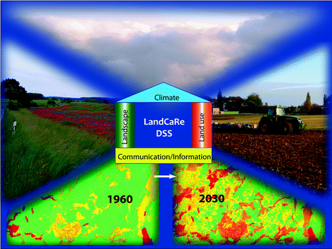
LandCaRe-DSS is a model-based interactive spatial information and DSS for developing climate change adaptation strategies for the sustainable use of agro-landscapes. Picture from the authors’ homepage (ZALF-LSA 2015)

Cluster 6, “Methods of resource and process evaluation and functional mapping”, concentrated on evaluating and monitoring soil and land resources. The cluster contains the following chapters:
-
1.
“Monitoring of Soil Fertility (Agroecological Monitoring)” (Chap. 24, Sychev et al.)
-
2.
“Probabilistic Assessment of Contemporary Soil Evolution (CSE) in the South of Western Siberia Based on Analysis of Soil Monitoring Data” (Chap. 12, Mikheeva)
-
3.
“The International Soil Classification System WRB, third edition, 2014” (Chap. 25, Schad)
-
4.
“An Emerging Method of Rating Global SQ and Productivity Potentials” (Chap. 26, Mueller et al.)
-
5.
“Small-Scale Soil Functional Mapping of Crop Yield Potentials in Germany” (Chap. 27, Hennings et al.)
The first chapter of this cluster (Sychev et al.) was a contribution of the VNIIA in Moscow, describing agro-ecological monitoring programmes which continue to run successfully. The author Mikheeva from ISSA Novosibirsk informed readers about a theoretical concept of soil state monitoring. The next two chapters dealt with soil classification. International efforts to protect soils from mismanagement and degradation have failed inter alia because of “Babylonian confusion” in terminology and the definition of soil types, processes and functions. Both chapters depicted solutions to overcome this situation. The author Schad (Technical University of Munich, Germany) presented the new International Soil Classification System WRB 2014 in brief. He headed an international working group who had elaborated this new system. It designates every soil unit on earth with a meaningful name. The approach used by Mueller et al. about the M-SQR allocates fertility numbers which describe the crop yield potentials of these soil units. The authors of this chapter came from ZALF Müncheberg, Germany, and a number of internationally acknowledged research institutions in Russia and Kazakhstan such as ISSA Novosibirsk, VNIIA Moscow, Kuban State Agrarian University in Krasnodar, the Institute of Peat and Organic Fertiliser in Vladimir, and the Kazakh Research Institute of Soil Science and Agrochemistry in Almaty. Hennings et al. created a small-scale SQ map of Germany by utilising the M-SQR approach and parameterising it with data from the soil information system of the Geo-Center in Hannover, Germany.
-
(1)
In Chap. 24 Sychev et al. analyzed fundamentals, developments, trends and present results of agroecological monitoring in Russia. Monitoring the ecological status of agricultural land is a fundamental precondition for controlling its sustainable functions for the human society and for maintaining ecosystem capacity. This system has been developed and operated by the Pryanishnikov Institute of Agrochemistry (VNIIA) in Moscow. Agroecological monitoring in Russia was installed in the 1970s and is based on a regular 5-year agrochemical survey of agricultural lands all over the country, more than 300 field experiments in all bioclimatic zones of the country and more than 1000 reference monitoring plots. In trials with different inputs of fertilisers the focus is on analysing soil fertility indicators and their impact on productivity. Some of these experiments are long-term experiments and part of international networks. The authors found significant tendencies towards decreasing soil fertility in some regions, such as decreased contents of humus and plant-available minerals, and topsoil acidification. Nutrient withdrawals must be made up for by regular fertilisation regimes, and nutrient mining must be avoided. The authors detected some knowledge gaps in the topic of balancing elements and modelling the agro-ecosystem’s response to climate and land use changes. They concluded that there is a need to implement modern measurement and modelling systems in some key long-term trials. The VNIIA has taken responsibility for coordinating running programmes in different regions and administrative units of the Russian Federation and for elaborating methodical guidelines and most advanced monitoring technologies. National and international cooperation, research programmes and networks are key for the agroecological monitoring systems of the twenty first century in addressing challenges for highly productive, stable, sustainable, and environmentally safe food production.
-
(2)
Mikheeva (Chap. 12 ) developed a theoretical approach to analysing soil monitoring data over a period extending from ten to one hundred years. Contemporary Soil Evolution (CSE) is considered a continuous block process of change in soil conditions leading to changes in the probability distribution functions (pdfs) of soil properties at different time steps. The author developed a method that consists of: (1) identifying the pdfs of soil properties, which means a quantitative evaluation of different kinds and parameters of pdfs according to data samples resulting from soil investigations; (2) calculating probabilistic indicators such as the statistical entropy of pdfs as probabilistic characteristics of soil status; and informational divergence that is a measure of pdf difference. A case study carried out on the large territory in the south of Western Siberia revealed new findings: changes in the probability structure of Kastanozem soil properties during CSE under natural processes and anthropogenous influences. Distinctions in pdfs were evaluated from the values of informational divergence and increment of statistical entropy, which were quantitatively different for soils of different granulometric composition; that is useful to identify the most vulnerable soils in the territory under investigation. It may be concluded that it is necessary to use probabilistic indicators to assess CSE from pdf alterations. They characterise a degree of influence of soil-forming factors and anthropogenous influences on the probability structure of the properties of the ground and its stability. Thus, they could be reliable indicators of environmental transformation; that is important for land resources research, land use policy planning, and basic research.
-
(3)
Schad (Chap. 25) reported on the third edition (2014) of the International Soil Classification System WRB. The first level of the WRB allocates soils to 32 Reference Soil Groups (RSGs), which are identified using a key. Many RSGs represent specific soil-forming processes, are representative of major soil regions or reflect special parent materials. In the second level, a set of qualifiers can be added to the name of the RSG. The principal qualifiers characterise the most significant properties of the particular RSG, and supplementary qualifiers give some further details about the soil. The WRB uses diagnostic horizons, diagnostic properties, and diagnostic materials. The definitions of many RSGs and qualifiers refer to the presence or absence of certain diagnostics at a certain depth. In addition, many definitions refer to individual features such as the base saturation or clay content. For naming a soil, the RSG has to be provided with all applicable principal and supplementary qualifiers. For map legends, the number of qualifiers depends on the scale. Detailed rules are established to create comprehensive names for map units at different scale levels. The major changes in WRB 2014 compared to WRB 2006 are the replacement of Albeluvisols by Retisols at RSG level. Retisols have a broader definition and include the former Albeluvisols. Fluvisols have moved down in the key to be the second last RSG, which changes some former Fluvisols into Solonchaks, Gleysols and others. This gives soil properties (salinity, redox conditions, etc.) priority over the mere position in the landscape. Three new diagnostic horizons have been defined. The chernic horizon is now required for Chernozems. The WRB supplements national classification systems. This is an important step towards uniform soil naming based on the criteria that characterise soil processes.
-
(4)
Chapter 26, by Mueller et al., provided information about an emerging approach for rating agricultural Soil Quality (SQ) and crop yield potentials consistently over a range of spatial scales. The authors developed and tested the Muencheberg Soil Quality Rating (M-SQR), an indicator-based straightforward method of assessing the overall agricultural SQ. It is a framework covering aspects of soil texture, structure, topography and climate which is based on eight basic indicators and more than 12 hazard indicators. Ratings are performed by visual methods of soil evaluation and supported by monthly climate data. A field manual is then used to provide ratings from tables based on indicator thresholds (Fig. 6). Finally, overall rating scores are given, ranging from 0 (worst) to 100 (best) to characterise crop yield potentials. The current approach is valid for grassland and cropland. Field tests in the main global agricultural regions confirmed the practicability and reliability of the method. At the field scale, soil texture and structure (Fig. 7) are most important criteria of agricultural SQ. At the global scale, climate-controlled hazard indicators of drought risk and the soil thermal regime are crucial for soil functioning and crop yield potentials. The final rating scores are well correlated with crop yields. Some tests were already carried out in Siberia (Smolentseva et al. 2014). The authors concluded that the combination of the M-SQR with the World Reference Base of soil resources (WRB 2014, Chap. 25) provides key information about main soil functions and processes. This system could be evolved for ranking and controlling agricultural SQ on a global scale as a basis for sustainable land use. Current concepts and data have led to a new crop yield potential map of Germany (Chap. 27) and could help create a similar map of Russia using the same methodology.
Fig. 6 
Front page of the field manual of the Muencheberg Soil Quality Rating (M-SQR). This indicator-based assessment method of soil quality of global lands has proven its applicability to Siberia at single sites. It has potential for mapping crop yield potentials over all Eurasian lands. The methodology is explained in Chap. 26, and the soil quality map of Germany, based on this approach, in Chap. 27. The field guide is available as internet source (ZALF-LWH 2013)
Fig. 7 
Soil structure expresses the influence of soil management by farmers on agricultural soil quality. Types of structure and biological pores are significantly correlated with soil functional parameters of water and gas transport. Visual soil structure serves thus as a quickly recognisable indicator of soil quality within modern soil evaluation frameworks such as M-SQR. Favourable soil structure under conservation tillage [rotations including ley (left) show a clearly better structure than monocultures (right)]
-
(5)
In Chap. 27 Hennings et al. explained the method of creating a SQ map based on the M-SQR approach (Chap. 26). It covers the arable lands of Germany. M-SQR rules and algorithms were adapted to the terminology and classification of soil parameters as defined by German soil mapping guidelines and were applied on soil-profile-related data sets of the land use stratified soil map of Germany at a scale of 1:1,000,000. According to the resulting thematic map, soils in Germany show a high yield potential for grain; the nationwide mean score is 64 out of 100 possible points. A moderate drought risk is the main crop yield limiting factor in Germany, while shallow soil depth and other crop yield-limiting factors may also be locally important. The authors concluded that the M-SQR methodology also enables the consistent incorporation of the newly created small-scale German crop yield potential map into a potential global SQ map.


Cluster 7 “Methods and technologies for controlling agricultural land use systems” contains the following four chapters:
-
1.
“Balance of Nutrients and the Optimization of their Use in Agroecosystems of the Russian Federation” (Chap. 28, Yefremov et al.)
-
2.
“Assessing and Controlling Land Use Impacts on Groundwater Quality” (Chap. 29, Eulenstein et al.)
-
3.
“Principles of Conservation Agriculture in Continental Steppe Regions” (Chap. 30, Suleimenov et al.)
-
4.
“Modern Cropping Systems and Technologies for Soil Conservation in Siberian Agriculture” (Chap. 31, Grunwald et al.).
The first two chapters explained methods of nutrient balance. These are important tools for evaluating the sustainability of agricultural practices towards maintaining soil fertility and preserving water and air from pollution. The chapter by Yefremov et al. came from VNIIA in Moscow, the chapter by Eulenstein et al. originated in ZALF Müncheberg with inputs from colleagues from some other research institutions and scientific companies in Russia, Kazakhstan, Germany and Austria. The next two chapters dealt with a crucial problem of agricultural land management in Siberia and throughout Russia: the lack of knowledge and experience with conservation agriculture. The first authors from the chapters explaining their principles and results thus came from abroad. The chapter by Suleimenov et al. came from the Scientific Production Center of Grain Farming named after A.I. Barayev, Shortandy, Kazakhstan. The chapter by Grunwald et al. originates from the Amazone Company and Halle University, both in Germany, with participation from the Barnaul Altai State Agrarian University and further institutions working on the KULUNDA project.
-
(1)
In Chap. 28 Yefremov et al. calculated the balances of the main plant nutrients nitrogen (N), phosphorus (P), and potassium (K) in certain regions of Russia and for the whole country over different time periods. They took into consideration all the main elements of the balances such as inputs of nutrients with mineral and organic fertilisers, seeds, biologically fixed N (symbiotic and non-symbiotic fixation) and rain, and outputs through crop uptake and losses through leaching, erosion and denitrification. The increase in the scope of chemicalisation in Russia led to the gradual elimination of the N and P deficit and a surplus of these nutrients at the national level—from an approximate balance since the mid-1960s to 37 and 25 kg/ha/year between 1986 and 1990, respectively. Annual deficits of K were also gradually reduced in the same period from −15 to −2 kg/ha. Today, agriculture has a serious annual excess of removal over input with a long-term deficit of up to 30, 10, and 27 kg/ha/year for N, P, and K, respectively as the result of a drastic decrease in mineral and organic fertilisation since the 1990s. The regional balance also provided a link with monitoring data on nutrient availability in arable soils. For the regions with high-input agricultural production the analysis of agrochemical survey data shows a consistent decrease in the weighted average content of available P and K forms in arable lands. The negative tendency was clear when the input of nutrients was inadequate to maintain soil fertility, as it was permanently lower than the amount of nutrient removal from soils. Negative hotspots were identified. Siberia is one such region where arable lands are not only under-fertilised but mainly receive N at the expense of P and K as a result of the farmers’ short-term decisions instead of long-term sustainability; in the Far East the situation is much more favourable. The development of policies and strategies relating to the fertilisation requirements of Russian agriculture should be based on providing balanced nutrition conditions for sustaining agricultural systems and soil fertility conservation.
-
(2)
Chapter 29 shows that protecting aquifers and open water bodies against pollution caused by ineffective and excessive fertilisation is a very important issue in modern agriculture (Fig. 8). Eulenstein et al. explained different balancing and measurement methods for the identification of nitrate problems and risks to water bodies. This chapter describes various methods for monitoring the efficiency of groundwater conservation by optimising soil and fertiliser management (Fig. 9) at different levels, from the farm through the soil zone to the groundwater. Nutrient balances are mandatory for all farms and fields in Germany. Depending on the spatial and temporal scale and the severity of the problem, different balancing and measurement methods are also mandatory or preferentially recommended. Balancing programmes differ between farm balances and field balances. Special methods are required in areas under particular groundwater protection for drinking water exploitation. Recommended sampling methods in aquifers included the direct push method, sampling from observation wells and sampling from multi-level observation wells.
Fig. 8 
Monitoring the quality of soil water by balancing and direct measurements (pore water, seepage water, runoff, groundwater) is particularly important on lands belonging to bioenergy farms. In biogas plants, liquid manure is a valuable fertiliser but may lead to excessive contents of nitrate and other agents in the soil and water at the local scale
Fig. 9 
Methods of precision agriculture can help to optimize fertiliser demands according to the spatio-temporal specific conditions of crops. The photo shows an “N-sensor” mounted on a tractor. It is combined with a GPS system and can be a basis for the operational control of fertiliser application
Nutrient balancing is managed using information and communication technology (ICT) and the latest farm management information systems in agriculture. In Germany, the methods described in this chapter are recommended as a work basis and decision tool for all bodies that have to assess the efficiency of agricultural operations in the framework of legal regulations or voluntary cooperation. The methods described here can be used by farmers, landscape planners, environmentalists, water authorities and other stakeholders as a basis for taking agricultural groundwater conservation measures. Decision trees, monitoring methods and information technologies have the potential of being transferable to other regions. Modern GIS-based software is available for this purpose.
-
(3)
In chap. 30, Suleimenov et al. reported on the principles of conservation agriculture and experimental results in Siberia and Kazakhstan. It is time to put an end to the non-sustainable summer-fallow-based cropping practiced in West Siberia. Conservation agriculture consists of three principles: (i) no-tillage or reduced tillage, (ii) permanent plant- or plant-residue-covered soil (mulch), and (iii) crop rotations. The authors conducted multi-factorial field experiments on crop rotations, tillage and soil fertility management on sites in Kazakhstan over more than 5 years and reviewed analogous studies from West Siberia. In studies conducted in northern Kazakhstan they found that cropland is most efficiently used in diversified crop rotations without black fallow. Summer fallow can be replaced by food legumes or legume forages. No-Till had an advantage in terms of crop yields over traditional tillage on the light-textured soils of the Kostanai province thanks to the better moisture conservation. On the heavy-textured soils of the Akmola province, traditional tillage had an advantage in some cases thanks to the better snowmelt water intake and more active nitrogen mineralisation. On the leached Chernozems of Trans-Ural Siberia, No-Till is feasible only with the application of higher rates of nitrogen fertiliser. In the forest-steppe zone of West Siberia, No-Till in the autumn provided the same grain yields as ploughing only when it was combined with the application of fertilisers, herbicides, fungicides and growth regulators. The major advantages of conservation agriculture are that it maintains soil fertility and long-term soil productivity, and prevents on-site and off-site damage by wind and water erosion. The authors concluded that conservation agriculture should become the dominating cropping system in Siberia on soils prone to erosion.
-
(4)
The chapter by Grunwald et al. (Chap. 31) analyzed topics of conservation agriculture from another perspective and presented the most advanced technologies for productive and sustainable cropping. No-till and direct seeding is a basic backbone of conservation agriculture. Applying this concept in agricultural practice does not work without modern technical equipment (Meinel et al. 2014). The authors reported on their first experiments in Siberia within the framework of the international research cooperation project KULUNDA. More reliable machinery for soil and crop management, exact seeding and spraying machinery in particular, will help to establish more robust crops which provide higher yield stability and better water use efficiency, and maintain soil fertility by protecting the soil against wind erosion. Modern drills have been designed for specialised direct seeding on stubble under steppe conditions. Wide row spacings and narrow, single depth-adjusted hoe opener systems are able to carry out shallow tillage only in the seeding furrow and to place seed and fertiliser exactly at the adjusted depth. The running experiments will deliver more detailed data about crop management and yields, soil fertility and micro-economy in the coming two years. Though those more detailed data are still required, authors may already conclude that their new approaches seem to confirm their hypotheses. Initial results in very dry weather conditions confirmed that conservation practices perform better when all aspects of soil protection, performance of machinery, plant establishment and yield are considered. Soils can be protected from wind erosion in an effective way using no-till systems, and the yield can be stabilised. They are soil conserving, practicable and effective, and have great potentials for broader application in Siberian agriculture.


3 Availability of Novel Methods and Conditions for Their Application
Part 3 of the book contains a number of methods with potential for application in Siberia. Their introduction and broader application would provide a shift in knowledge and technology towards better monitoring and the sustainable use of land and water resources. Table 2 provides an overview of novel tools. There are various potential addressees for these methods. Most tools could be applied by research and monitoring groups, but landscape planners, consultants, farmers, decision makers and other people could also benefit from them.
The novel methods presented have a different degree of accessibility. Some require investment, others are available for free. We may distinguish between:
-
(1)
Well-engineered commercial products. The measurement devices presented in this group are useful for application in research and monitoring and may provide a knowledge shift in understanding soil hydrological processes (EEM-HYPROP, lysimeters and hydrological field setups for arable lands and forest ecosystems). Water and gas flux measurement devices are also in high demand as research tools. Machinery for conservation tillage, and special agrochemicals, are very important for the functioning of conservation agriculture but costly for farmers.
-
(2)
Knowledge-based, virtual tools for the recognition, assessment and evaluation of states and processes in agricultural landscapes. This includes land evaluation and mapping frames and guidelines, agro-ecosystem models, GIS and remote sensing tools. Some addressees of these evaluation methods and models are also researchers, but others are monitoring and planning groups, authorities or advanced farmers. These methods are freely available, but they also require qualifications and a lot of creativity. Access to geospatial data, especially at high resolution, is sometimes commercially restricted by costs and licensing.
What all the new methods presented here have in common is that their introduction requires the people dealing with them to have particular qualifications. Also, the application of commercially available measurement devices and systems needs to be embedded in an advanced and creative environment, dominated by motivated and skilled scientific staff.
It should be mentioned that further transferrable tools are available as well. They have already been described in a book about monitoring and management of soil and water resources in Central Asia (Mueller et al. 2014a, b, c) but are applicable in Siberia, too. Most of these methods are listed in Table 3.
The authors are aware that presenting novel methods in a book can only set slight impulses for their potential application. The key to their real application is mental access to available research tools, including “non-physical” ones. This clearly requires open minds among scientists and decision makers, plus high-level training and qualification in their handling, based on a standard level of scientific education.
4 Addressing Climate Change Requires Innovations in Landscape Research
Climate change in Siberia is significant and progressing. Chaps. 1, 2, 6, 10 and 11 presented data of significant warming, and indicated some possible consequences for nature and civilisation. Climate change will lead to a shift in the natural vegetation northwards and increase the potential for agriculture as a whole. Its impact on water resource availability, however, is largely uncertain at the time being.
Can this potential be utilised to improve food security? Dronin and Kirilenko (2011) doubt this, mainly because of drought risk and the lower soil fertility of Taiga soils. On the other hand, drought risk can be diminished by irrigation, and Taiga soils of limited inherent fertility can be improved by proper soil reclamation and management. In North Germany, soils of the Podsol type which are traditionally considered infertile may provide cereal yields of 10 t/ha thanks to suitable climate and careful soil cultivation over decades or centuries. Soils do not only degrade as a result of the climate and human impacts. They may also be improved (aggraded) in their productivity function by human activity (Geßl and Nestroy 2008; Mueller et al. 2014c). Framework conditions determined by society are decisive factors for utilising the potential of land for farming or not.
Climate change will create new bio-physical facts. How will the newly created landscapes develop? All scenarios considering factors of societal behaviour are very uncertain because of the apparently unforeseeable reaction of human civilisation. Even a simple, basic question such as “Can soil reclamation and sustainable use be achieved on land under varied ownership?” lies beyond the topic of this book and beyond our expertise.
Instead, we concentrated on other subtopics associated with climate change and more related to questions which can largely be answered from the viewpoint of applied natural science:
“Can soil reclamation and management be performed in an effective and sustainable way by applying obsolete technologies without public monitoring and control?” Of course, they cannot. Chaps. 7, 30 and 31 show that on soils prone to erosion by wind and water this will not be possible. Under those conditions there is no alternative to conservation agriculture if those soils need to be cropped. On the other hand, in more detail, a dualism in terms of “yes” or “no” will always fail when assessing landscapes and preparing planning decisions. The recognition of the ecosystem’s behaviour has to follow dialectical principles and consider back coupling processes, disturbances by boundary and neighbour systems, memory effects and other aspects. For example, in the case of successful soil reclamation by drainage, irrigation or other management technologies, undesired side effects or subsequent damage may occur besides the desired effects of improved fertility (Zaydelman 2009). The same principle holds for conservation agriculture, which is not practicable without increased herbicide application. One cannot rule out possible consequential damage to agro- or aquatic ecosystems.
It is very likely that the utilisation of the enhanced agroclimatic potential of a warming Siberia can only be achieved by drainage and irrigation in many parts of the region. In the south, measures against soil degradation by salinisation and sodification have to be taken. Improved knowledge and modern technologies for soil reclamation are available (Berezin et al. 2013; Evans 2014; Michel and Dannowski 2014; Qadir et al. 2014; Semendyaeva et al. 2015), many of them again outside of Siberia (Fig. 10). However, drainage, water table control and irrigation will have implications for soil development, vegetation and biodiversity (Mueller et al. 2000, 2002). They need to be planned and handled with more care than formerly. If planned for larger regions or watersheds they will require impact assessment procedures (Helming 2014) including economic and ecological trade-offs. The M-SQR (Chap. 26) could serve as an important decision tool within those procedures by making them more objective and comparable.

Examples of modern drainage and irrigation technology: a Well-constructed ditch for land drainage and water table control, b Laser-controlled machine for trenchless subsurface drainage, c Automatically operating low-pressure sprinkler irrigation machine. It is likely that these and further technology and knowledge about their operation will be needed to exploit the higher land use potential of a warming Siberia. Their application requires complex planning, careful construction, operation and maintenance to achieve their main effects and to minimise negative side effects
Permanent research and monitoring about climate change and landscape development will increase our knowledge and allow new conclusions to be drawn for optimising the environmentally sound use of resources. Consequently, all decisions about resource allocation have to be based on the latest state of the science. This is our claim and mission, and we can already answer a key question in this context: “Can we develop strategies for the optimum use of landscapes which have been modified by climate change?” Yes, we can. Chapters 13–29 give examples of new monitoring, assessment and modelling tools that are required for those thought experiments. A further example of a question might be: “Is a recently observed altered water quality caused by climate change or caused by poor practices in agricultural and forest management?” This question is not yet very relevant to Siberia because mining and industrial activities have been identified as the main source of soil and water pollution there. However, it is a permanent issue in Western Europe, has growing relevance to European Russia and could reach Siberia soon. It can be answered using the monitoring programmes (Fig. 11), modelling studies and technologies shown in several chapters of this book, such as Chaps. 3–6, 14, 28 and 29.

Agricultural field experiments, and in particular long-term experiments (LTEs), are a very valuable source of information about land use strategies, management systems, nutrient cycling, carbon sequestration, climate change implications and other topics and data. The monitoring network of the Pryanishnikov All-Russian Research Institute of Agrochemistry (VNIIA) in Moscow provides the derivation of scientific recommendations for research and practice based on this information. The network needs to be extended by including more Siberian sites and modernized by installing automatically operating monitoring stations at key sites. The figure depicts the LTE on the “Effect of mineral fertilization and liming on crop productivity and fertility of soddy-podzolic soil” carried out by the Krasnoyarsk State Agricultural Research Institute (NIISKH). Source VNIIA
Summarising these considerations, it may be concluded that climate change to Siberia is evident and may be a threat or an opportunity. Society needs to find solutions and make mandatory decisions. Introducing and enabling climate-strategic agriculture requires a permanent dialogue between scientists on the one hand and policy makers and managers on the other hand to convert research data into flexible policy and action plans (Lal 2013). There is no alternative to permanent research and monitoring and to applying the latest knowledge and technologies in adaptation programmes. Not doing this, and neglecting the state of the science, would have negative implications for nature and future generations. The degree of application of our monitoring and management tools for land and water resources in Siberian research and practice could be a first good indicator of the willingness and ability of responsible decision makers to address important aspects of climate change.
5 Suggestions for Initiating Sustainable Use of Land and Water Resources
Analyses of the first chapters showed that agriculture has operated in a relatively endemic and unsustainable manner in Siberia. Research and monitoring in agriculture and related disciplines are also traditional and require modernisation and better linkage with the European scientific community. The chapters reviewed above presented some novel methods which could help to improve the situation at different levels of science and technology significantly. However, how to make them operational?
Reading the book chapters and understanding their key messages can be only a first step towards achieving our goals: initiating joint actions for sustainably handling land and water resources in rural landscapes.
On a global scale, international cooperation in science and technology has been a proven key to practical progress based on new ideas developed at any location in the world. It is high time to strengthen cooperation in scientific research and teaching in agricultural and agri-environmental disciplines on a Eurasian scale, with a strong focus on Russia and Siberia. An emerging generation of Russian scientists well educated in their scientific discipline and in English, the language of science, will be involved.
The contributors to this book are willing to integrate their inventions and other novel methods developed into these initiatives. They represent an immense international research network with great potential for supporting activities of agri-environmental research, education and outreach in Siberia in the coming years. Those actions need to be better interlinked with currently running activities. Soil-ecological field courses across West Siberia (Siewert et al. 2014, Fig. 12), international summer schools at leading Siberian research institutes and the international research project KULUNDA (BMBF 2014) are some initial promising activities on the path to more durable cooperation projects.

Ecological summer schools and excursions have been excellent initiatives for teaching students about ecosystem functioning and sustainable landscape handling. The left photo shows a group working in a mountain tundra landscape, and the right photo a group in a mountain desert of the Altai. Photos courtesy of Christian Siewert
Strategies of cooperation in science, technology and education between the EU (and its constituent countries) and Russia must become more sustainable. For example, pilot project groups for field-testing novel methods and technologies could be installed at Siberian research institutes. Their work could be supported by external scientific consultants. In the area of education, it is worth thinking about “Schools of Environment and Natural Resources”. A single Siberian scientific research and education centre for “Rural Landscape Research” would express the required focus on the sustainable use of land and water resources associated with problems of agriculture, forestry, inland fishery, environmental protection and further related topics. Employing external lecturers would mean that new ideas and methods could have an innovative effect. Also, professors and academic teachers at universities in Russia have a particular responsibility to consider the latest findings of science and technology in their lessons for students.
Maintaining rural landscapes and their basics (fertile, clean soils and pure water) requires some effort in the urban century (Watson 2014). New initiatives for Siberia could be effectively interlinked with efforts to improve the situation in Central Asia. Former Soviet Republics there share similar problems related to the need for innovation in soil and water monitoring and management (Mueller et al. 2014a; Meyer and Lundy 2014). Large regions of Kazakhstan border Siberia. The Kulunda steppes and their desertification problems, transboundary river water management, research and monitoring methodologies and many other issues are common with Siberia. All contributing partners will benefit from those innovative initiatives and from a durable scientific and technological partnership. Maintaining the functions of great landscapes for future human generations will be the reward of those efforts.
6 Overall Conclusions
-
1.
Huge natural resources of Siberia, the Asian part of Russia, are the basis for the welfare of modern urban Russia. The land and water resources of Siberia are of crucial importance for global cycles and show great potential for effective, sustainable and ecologically viable activities around their handling and utilisation. This would provide a solid basis for maintaining natural landscapes, developing rural cultural landscapes, and achieving food security and a high living standard of the population, rural regions included.
-
2.
Not only the resource-extracting and processing industries, but also forestry, agriculture and fishery have capitalised land and water resources in a wasteful way. Peatlands, Tundra, Taiga, and most aquatic ecosystems are endangered by these industries, industrial air pollution and uncontrolled natural and human-induced hazards (fires, thermokarst processes, floods, droughts, insect outbreaks). Agriculture is in a recession and operates inefficiently and soil-destructively. The impact of agriculture on water quality is still low but will increase. The rural infrastructure is on the verge of collapse.
-
3.
Measures for sustainably handling land and water resources should be initiated soon. This has to be managed based on a profound knowledge and reliable data about the significance of trends in ecosystem drift. Russia has great traditions in landscape research disciplines such as geography, soil science, hydrology and agronomy. They experienced a great development during the economic revival of the country in the post-war period. Further substantial progress has been achieved in all these fields of science over the past 25 years. Respectable basic monitoring programmes for soil and water quality have been installed but need to be modernised and interlinked with the scientific community.
-
4.
Addressing climate change requires innovations in landscape research. Novel methods and technologies developed outside Siberia for monitoring and controlling land and water resources, meeting international standards, should be set in operation. The above book chapters present an array of methods which can provide a knowledge shift, particularly in agri-environmental research, monitoring and agricultural practice.
-
5.
More than 15 concrete monitoring and management tools could immediately be introduced into research and practice, some of them without monetary investment. The agro-ecosystem and plant growth model MONICA, the DSS LandCaRe-DSS and the M-SQR for estimating SQ and crop yield potentials are some of these freely available tools with a focus on preserving and improving rural landscapes.
-
6.
If any cropping practices are required for natural steppe regions, the depicted principles and modern technologies of conservation agriculture are needed to protect soils from erosion and degradation by wind and water.
-
7.
Strengthening international and national cooperation will be key to substantial progress in monitoring, understanding and controlling landscape processes with a focus on the soil and water resources of Siberia. A new era of innovative, durable cooperation should be initiated. The book contributors are part of an immense innovation network which should be employed to achieve both significant disciplinary and synergetic effects.
-
8.
New initiatives for monitoring and managing the land and water resources of Siberia could be effectively interlinked with efforts to improve the situation in parts of European Russia and in Central Asia. These regions share similar problems of natural conditions, landscape development and the need for innovation. All contributing partners, future human generations and great landscapes will benefit from those innovative initiatives.
References
Balla D, Omar M, Maassen S, Hamidov A, Khamidov M (2014) Efficiency of duckweed (Lemnaceae) for the desalination and treatment of agricultural drainage water in detention reservoirs. In: Mueller L, Saparov A, Lischeid G. (eds) Novel measurement and assessment tools for monitoring and management of land and water resources in agricultural landscapes of Central Asia. Springer International Publishing, pp 423–440. http://springerlink.bibliotecabuap.elogim.com/chapter/10.1007/978-3-319-01017-5_25. Accessed 27 Feb 2015
Behrendt A, Fischer A, Kaiser T, Eulenstein F, Ortmann S, Berger A, Mueller L (2014) Multi-species grazing on deer farms. In: Mueller L, Saparov A, Lischeid G (eds) Novel measurement and assessment tools for monitoring and management of land and water resources in agricultural landscapes of Central Asia. Springer International Publishing, pp 491–501. http://springerlink.bibliotecabuap.elogim.com/chapter/10.1007/978-3-319-01017-5_30. Accessed 27 Feb 2015
Berezin LV, Saparov AS, Kan VM, Shayakmetov MR (2013) Technology of integrated ecosystem reclamation of Russia and Kazakhstan (Texнoлoгия кoмлeкcнoй мeлиopaции экocиcтeм Poccии и Кaзaxcтaнa). Almaty-Omsk 1st edition 2013, p 215 (in Russian)
BMBF (2014) www.kulunda.eu. Accessed 27 Feb 2015
Djanibekov N, Sommer R (2014) Integrated Decision Support for Sustainable and Profitable Land Management in the Lowlands of Central Asia. In: Mueller L, Saparov A, Lischeid G (eds) Novel Measurement and Assessment Tools for Monitoring and Management of Land and Water Resources in Agricultural Landscapes of Central Asia. Springer International Publishing, pp. 407–422. http://springerlink.bibliotecabuap.elogim.com/chapter/10.1007/978-3-319-01017-5_24. Accessed on 30 Jan 2015
Dronin N, Kirilenko A (2011) Climate change, food stress, and security in Russia. Reg Environ Change 11(Suppl 1):S167–S178. doi:10.1007/s10113-010-0165-x
Evans RG (2014) Advanced technologies for irrigated cropping systems. In: Mueller L, Saparov A, Lischeid G (eds) Novel measurement and assessment tools for monitoring and management of land and water resources in agricultural landscapes of Central Asia. Springer International Publishing, pp 475–489. http://springerlink.bibliotecabuap.elogim.com/chapter/10.1007/978-3-319-01017-5_29. Accessed 27 Feb 2015
Geßl A, Nestroy O (2008) Veränderungen landwirtschaftlich genutzter Böden in Österreich, dargestellt an den Erhebungen der Bodenschätzung. Mitt. naturwiss. Ver. Steiermark Band 137 pp 5–24 Graz 2008. http://www.landesmuseum.at/pdf_frei_remote/MittNatVerSt_137_0005-0024.pdf. Accessed 27 Feb 2015
Godbersen L, Utermann J, Duijnisveld WHM (2014) Methods in the exploratory risk assessment of trace elements in the soil-groundwater pathway. In: Mueller L, Saparov A, Lischeid G (eds) Novel measurement and assessment tools for monitoring and management of land and water resources in agricultural landscapes of Central Asia. Springer International Publishing, pp 289–314. http://springerlink.bibliotecabuap.elogim.com/chapter/10.1007/978-3-319-01017-5_17. Accessed 27 Feb 2015
Helming K (2014) Impact assessment for multifunctional land use. In: Mueller L, Saparov A, Lischeid G (eds) Novel measurement and assessment tools for monitoring and management of land and water resources in agricultural landscapes of Central Asia. Springer International Publishing, pp 223–234. http://springerlink.bibliotecabuap.elogim.com/chapter/10.1007/978-3-319-01017-5_12. Accessed 27 Feb 2015
Hennings V (2014) Use of pedotransfer functions for land evaluation: mapping groundwater recharge rates under semi-arid conditions. In: Mueller L, Saparov A, Lischeid G (eds) Novel measurement and assessment tools for monitoring and management of land and water resources in agricultural landscapes of Central Asia. Springer International Publishing, pp 249–262. http://springerlink.bibliotecabuap.elogim.com/chapter/10.1007/978-3-319-01017-5_14. Accessed 27 Feb 2015
Kastanek F (1995) Kritische Bemerkungen zur Verwendung von Lysimetern. 5. Gumpensteiner Lysimetertagung „Stofftransport und Stoffbilanz in der ungesättigten Zone“ BAL Gumpenstein. 25-26 April 1995. BAL Bericht, pp 93–102
Lal R (2013) Climate-strategic agriculture and the water-soil-waste nexus. J Plant Nutr Soil Sci 176:479–493. doi:10.1002/jpln.201300189
Lischeid 2014 Non-linear approaches to assess water and soil quality. In: Mueller L, Saparov A, Lischeid G (eds) Novel measurement and assessment tools for monitoring and management of land and water resources in agricultural landscapes of Central Asia. Springer International Publishing, pp 365–378. http://springerlink.bibliotecabuap.elogim.com/chapter/10.1007/978-3-319-01017-5_21. Accessed 27 Feb 2015
Michel R, Dannowski R (2014) Using soil–water–plant models to improve the efficiency of irrigation. In: Mueller L, Saparov A, Lischeid G (eds) Novel measurement and assessment tools for monitoring and management of land and water resources in agricultural landscapes of Central Asia. Springer International Publishing, pp 379–387. http://springerlink.bibliotecabuap.elogim.com/chapter/10.1007/978-3-319-01017-5_22. Accessed 27 Feb 2015
Meinel T, Grunwald L-C, Akshalov K (2014) Modern technologies for soil management and conservation in northern kazakhstan. In: Mueller L, Saparov A, Lischeid G (eds) Novel measurement and assessment tools for monitoring and management of land and water resources in agricultural landscapes of Central Asia. Springer International Publishing, pp 455–464. http://springerlink.bibliotecabuap.elogim.com/chapter/10.1007/978-3-319-01017-5_27. Accessed 27 Feb 2015
Meissner R, Rupp H, Seyfarth M (2014) Advanced technologies in Lysimetry. In: Mueller L, Saparov A, Lischeid G (eds) Novel measurement and assessment tools for monitoring and management of land and water resources in agricultural landscapes of Central Asia. Springer International Publishing, pp 159–173. http://springerlink.bibliotecabuap.elogim.com/chapter/10.1007/978-3-319-01017-5_8. Accessed 27 Feb 2015
Meyer BC, Lundy L (eds) (2014) Integrated water cycle management in Kazakhstan. Al-Farabi Kazakh National University, Publishing House, Almaty, p 320. ISBN: 978-601-04-0900-2
Mueller L, Frielinghaus M, Schindler U, Behrendt A, Schmidt W (2000) Bodenschutz auf Standorten der Flussniederungen und Niedermoore. Archiv für Acker- und Pflanzenbau und Bodenkunde 45:239–262. http://www.zalf.de/de/forschung/institute/lwh/mitarbeiter/lmueller/Documents/L7_60gruen.pdf. Accessed 27 Feb 2015
Mueller L, Schindler U, Behrendt A, Frielinghaus M (2002) Protecting lowland soils by agricultural practices. In: Proceedings 12th international soil conservation organization conference, 26–31 May 2002. Beijing, China, pp 328–333. http://www.zalf.de/de/forschung/institute/lwh/mitarbeiter/lmueller/Documents/L7_65gruen.pdf. Accessed 27 Feb 2015
Mueller L, Suleimenov M, Karimov A, Qadir M, Saparov A, Balgabayev N, Helming K, Lischeid G (2014a) Land and water resources of Central Asia, their utilisation and ecological status. In: Mueller L, Saparov A, Lischeid G (eds) Novel measurement and assessment tools for monitoring and management of land and water resources in agricultural landscapes of Central Asia. Springer International Publishing, Environmental Science and Engineering 2014, pp 3–59. Accessed 27 Feb 2015
Mueller L, Behrendt A, Shepherd TG, Schindler U, Ball BC, Khudyaev S, Kaiser T, Ralf Dannowski R, Eulenstein F (2014b) Simple field methods for measurement and evaluation of grassland quality. In: Mueller L, Saparov A, Lischeid G (eds) Novel measurement and assessment tools for monitoring and management of land and water resources in agricultural landscapes of Central Asia. Springer International Publishing, Environmental Science and Engineering 2014, pp 199–222. http://springerlink.bibliotecabuap.elogim.com/chapter/10.1007/978-3-319-01017-5_11. Accessed 27 Feb 2015
Mueller L, Schindler U, Ball BC, Smolentseva E, Sychev VG, Shepherd TG, Qadir M, Helming K, Behrendt H, Eulenstein F (2014c) Productivity potentials of the global land resource for cropping and grazing. In: Mueller L, Saparov A, Lischeid G (eds) Novel measurement and assessment tools for monitoring and management of land and water resources in agricultural landscapes of Central Asia. Springer International Publishing, Environmental Science and Engineering 2014, pp 115–142. http://springerlink.bibliotecabuap.elogim.com/chapter/10.1007/978-3-319-01017-5_6. Accessed 27 Feb 2015
Qadir M, Vyshpolsky F, Mukhamedjanov K, Bekbaev U, Ibatullin S, Yuldashev T, Noble AD, Karimov A, Mirzabaev A, Aw-Hassan A (2014) Enhancing the productivity of high-magnesium soil and water resources in Central Asia. In: Mueller L, Saparov A, Lischeid G (eds) Novel measurement and assessment tools for monitoring and management of land and water resources in agricultural landscapes of Central Asia. Springer International Publishing, Environmental Science and Engineering 2014, pp 465–474. http://springerlink.bibliotecabuap.elogim.com/chapter/10.1007/978-3-319-01017-5_28. Accessed 27 Feb 2015
Schindler U, Mueller L (2005) Comparison of deep seepage estimations of a virtual with a real lysimeter by means of TDR measurements. Int Agrophysics Lublin 19:69–73. http://www.old.international-agrophysics.org/artykuly/international_agrophysics/IntAgr_2005_19_1_69.pdf. Accessed 27 Feb 2015
Semendyaeva NV, Lomova TG, Utenkov GL (2015) Scientific grounds of agricultural alcaline soil development in the south of the Western Siberia from 1969 to 2014 (Hayчнoe oбecпeчeниe ceльcкoxoзяйcтвeннoгo ocвoeния coлoнцoвыx пoчв югa зaпaднoй cибиpи зa пepиoд c 1969 пo 2014 г.) Vestnik Novosibirsk State Agrarian University NGAU 1(34)/2015, pp 7–21
Siewert C, Barsukov P, Demyan S, Babenko A, Lashchinsky N, Smolentseva EN (2014) Teaching soil science and ecology in West Siberia: 17 years of field courses. Environ Edu Res 20(6):858–876. http://dx.doi.org/10.1080/13504622.2013.839778. Accessed 27 Feb 2015
Smolentseva E, Smolentsev B, Pachkin K, Mueller L (2014) Assessing the soil quality and crop yield potentials of some soils of Eurasia. In: Mueller L, Saparov A, Lischeid G (eds) Novel measurement and assessment tools for monitoring and management of land and water resources in agricultural landscapes of Central Asia. Environmental Science and Engineering 2014, pp 505–517. http://springerlink.bibliotecabuap.elogim.com/chapter/10.1007%2F978-3-319-01017-5_31. Accessed 27 Feb 2015
Watson EE (2014) The continuing significance of rural landscapes in the urban century. Rural Landscapes 1(1): 3:1–3. doi:http://dx.doi.org/10.16993/rl.ab
ZALF-LWH (2013) The Muencheberg Soil Quality Rating. URL:http://www.zalf.de/de/forschung/institute/lwh/mitarbeiter/lmueller/Documents/field_mueller.pdf. Accessed 27 Feb 2015
ZALF-LSA (2015) URL:http://www.zalf.de/en/forschung/institute/lsa/forschung/Folgenab/landcare/Pages/default.aspx. Accessed 27 Feb 2015
Zaydelman FR (2009) Genesis and ecological basics of soil and landscape reclamation (Гeнeзиc и экoлoгичecкиe ocнoвы мeлиopaции пoчв и лaндшaфтoв) KDU Moscow 3rd edition 2009, p 720. ISBN 978-5-98227-554-7 (in Russian)
Author information
Authors and Affiliations
Corresponding author
Editor information
Editors and Affiliations
Rights and permissions
Copyright information
© 2016 Springer International Publishing Switzerland
About this chapter
Cite this chapter
Mueller, L., Sheudshen, A.K., Sychev, V.G., Romanenkov, V.A., Dannowski, R., Eulenstein, F. (2016). Potential of Applying Novel Monitoring and Management Methods to Siberian Landscapes. In: Mueller, L., Sheudshen, A., Eulenstein, F. (eds) Novel Methods for Monitoring and Managing Land and Water Resources in Siberia. Springer Water. Springer, Cham. https://doi.org/10.1007/978-3-319-24409-9_32
Download citation
DOI: https://doi.org/10.1007/978-3-319-24409-9_32
Published:
Publisher Name: Springer, Cham
Print ISBN: 978-3-319-24407-5
Online ISBN: 978-3-319-24409-9
eBook Packages: Earth and Environmental ScienceEarth and Environmental Science (R0)