
Abstract
Increasing roadway capacity has been the traditional method to cope with and manage traffic congestion. Capacity enhancement strategies generally improve mobility of all road users. Sometimes, however, they are designed to improve mobility of special users—such as high-occupancy vehicles (e.g., carpools and public transport vehicles).
Access provided by Autonomous University of Puebla. Download chapter PDF
Keywords
These keywords were added by machine and not by the authors. This process is experimental and the keywords may be updated as the learning algorithm improves.
1 Introduction
Increasing roadway capacity has been the traditional method to cope with and manage traffic congestion. Capacity enhancement strategies generally improve mobility of all road users. Sometimes, however, they are designed to improve mobility of special users—such as high-occupancy vehicles (e.g., carpools and public transport vehicles).
There are two types of capacity enhancement strategies: (1) those that restore lost capacity by eliminating operational inefficiencies and bottlenecks in the existing roadway system; and (2) those that add new road capacity. This chapter describes strategies that increase the operational efficiency of the existing system. Chapter 17, discusses strategies that add new roadway capacity.
This chapter shows how operational strategies can reduce congestion by making better use of existing streets and highways. Getting the “most” from existing streets and highways has been a long-established traffic engineering practice to increase capacity, reduce delay, and improve traffic safety in the short term at modest costs and with minimum adverse community impacts.
2 Scope
The various sections of this chapter describe the strategies that improve traffic operations, give application guidelines for each, suggest relevant analysis methods, and set forth likely effectiveness of the various strategies. In this respect the suggested analysis methods complement the various capacity, delay, and level of service procedures of the 2010 Highway Capacity Manual [1].
Traffic operational improvements that increase capacity include a combination of traditional strategies such as: parking restrictions, signal timing and signal coordination improvements, turn restrictions at key intersections, one-way streets, reversible commuter lanes, movable median barriers during peak periods, better lane striping, managing road access to and from traffic generators, etc. They also include the application of advanced technologies that use real-time information of traffic conditions to implement dynamic traffic control strategies that optimize traffic flow and provide travelers with real-time information on traffic conditions.
3 Analysis Overview
Congested roadways and intersections generally can be identified by observations and from travel time and delay studies. Demand-to-capacity analyses are useful in identifying problem locations. As a general guide, improvements should reduce the demand-to-capacity ratio to less than 0.85 for achieving stable flow. Reducing the red times on each approach at signalized intersections can also reduce delays.
The 2010 Highway Capacity Manual [1] contains detailed procedures for estimating capacity, delays, and facility performance. Additional guidelines are found in the various editions of “Traffic Engineering” handbooks that are published by the Institute of Transportation Engineers [2] and the Manual of Uniform Traffic Control Devices for Streets and Highways [3]. These procedures can be used to estimate change in service levels resulting from traffic operational improvements.
The sections that follow give descriptions, applications, guidelines, and travel time savings for the following operational strategies:
-
Traffic Signal Timing and Coordination
-
On-street Parking and Loading Zone Management
-
Intersection Turn Controls and Management
-
One-way Streets
-
Changeable Lane Assignment
-
Ramp Controls
-
Access Management
-
Intelligent Transportation Systems
-
Traveler Information Systems
-
Roadside Electronic Screening Programs for Commercial Vehicles
-
Integrated Corridor Management
4 Traffic Signal Timing and Coordination
Effective traffic signal timing and coordination is one of the most basic and effective strategies to reduce congestion. The Federal Highway Administration (FHWA) indicates that there are more than 240,000 traffic signals in the United States. The agency estimates that poor traffic signal timing accounts for 5–10 % of all traffic delays or almost 300 million vehicle hours of delay on major roadways alone. Over 75 % of the signals in the US could be improved by adjusting and updating equipment or by adjusting timing and coordination plans. The FHWA recommends that jurisdictions assess retiming signals at least once every 3 years.
4.1 Signal Location and Spacing
Traffic signals should be installed at intersections that meet the national Manual on Uniform Traffic Control Devices recommendations [3] and state standards pertaining to minimum volume and annual crashes. Too many signals along a roadway generally should be avoided, since adding signals generally reduces travel speeds and increases delay (see Table 16.1).
Typically signals are located almost every block in the central business district and other major commercial centers. In cities, average spacing should not be closer than one quarter mile; while wider signal spacing is desirable in suburban areas.
4.2 Cycle Length
The cycle lengths should (1) accommodate conflicting traffic volumes at intersections without excessive delay on each approach, (2) provide enough green time on side streets to let pedestrians cross safely, and (3) permit effective coordination of signals along a roadway and. Within this context, cycle lengths should be as short as possible. When cycle lengths are too long, delays can be excessive. Although cycle lengths depend upon the number of phases, they generally should not be longer than 2 min. Shorter cycles are desirable where transit vehicles operate along the streets.
4.3 Cycle Phases
The number of phases should be kept at a minimum. Two-phase operation is desirable wherever possible. As the number of phases increases the red time on each approach increases and so does delay. A third phase, and sometimes a fourth phase, is needed to serve left turns or accommodate a third street entering the intersection. Additional pedestrian-only phases generally should be limited to locations with heavy turning movements and heavy pedestrian crossings.
Design and operating strategies that restrict or divert left turns and simplify intersection geometry can reduce both cycle lengths and delay.
4.4 Coordination
Coordinating traffic signals along a roadway minimizes stops and delays during both peak and off-peak hours. Coordination requires signals to operate on common cycle lengths. In addition, uniform spacing of signals is desirable.
Signals should be coordinated on city streets (where they are spaced close together), and on suburban roads where their spacing does not exceed one mile.
The traffic speeds that result from coordination depend upon both the signal spacing and the cycle length. Higher speeds require longer distances between signals; shorter cycle lengths and closer spacing of signals produce lower speeds [5].
Figure 16.1 shows these relationships.

Speed of traffic progression as a function of cycle length and signal spacing. Source Reference [5], p 57. Figure 7.1
The maximum average traffic speed that can be achieved through a series of signalized intersections depends also on the spacing of the signals. Uniform, or near uniform, signal spacing is essential in maximizing traffic speed. Where this is the case, the through band, which indicates the amount of traffic that can pass through a series of signals during the green phase, equals the green time provided by the signal. Thus signals placed at quarter mile intervals can permit a through band in each direction, at the designated progression speed (e.g., 30 mph using a 60 s cycle). If a new signal is introduced, say one quarter mile from the next signal, the through band of progression is significantly reduced.
4.5 Operating Strategies [5]
Cycle lengths, phase splits, offsets, and progression speeds can vary throughout the day. In some cases, where traffic volumes are unbalanced (e.g., inbound in the morning and outbound in the evening) the signal progression should favor the heavier traffic flow.
4.6 Equipment
Signals can be pre-timed or traffic-responsive. Computer control and coordination of signals is a common practice. Fully traffic-actuated signals work best at isolated intersections. Semi-actuated signals are appropriate at minor streets and should be integrated with the coordination pattern.
Traffic adaptive signals represent the state of practice and are increasingly popular in large metropolitan areas. These traffic adaptive controls, used for example in Los Angeles and Manhattan, adjust the signal splits of each cycle based on traffic volume, but can retain the specified background cycles.
4.7 Costs
Implementing signal coordination plans and upgrading signal control equipment generally involves considerable costs. Costs also include installing real-time traffic sensors to update signal timing based on actual traffic demand.
Sunkan [6] estimated the cost to retime signals in the range of $2,000–$3,100 per intersection; while the reported costs of computerized synchronization systems in several cities ranges between $30,000 and $60,000 per intersection.
4.8 Reported Time Savings
Reported travel time savings resulting from traffic signal timing improvements, operational treatments along arterial streets, and improved freeway operations are shown in Tables 16.2 and 16.3, respectively. These tables, assembled from various sources, provide a basis for estimating travel time savings from similar congestion reduction treatment elsewhere.
5 Curb Parking and Loading Zone Management
On-street parking and loading zones are found throughout the metropolitan area. Curb parking and loading/unloading activities are usually concentrated in older commercial districts and in densely populated residential areas where there is limited off-street parking space available.
On-street parking or standing along major streets often takes away street space that could be used for the movement of motor vehicles. These events frequently create congestion especially during the peak travel times and sometimes throughout the day. A short stretch of curb parking can reduce the capacity of an entire street.
5.1 Curb Parking Restrictions
Curb parking restrictions can provide congestion relief quickly with minimum costs. They can apply to one or both sides of the street. Restrictions are normally applied during busy traffic periods, but they can sometimes extend throughout the day.
5.2 Installation Guidelines
Curb parking restrictions are generally appropriate when the following conditions apply:
-
Roadways operate at Service Level E or F
-
At intersection approaches, at transit stops and at fire hydrant
-
Curb bus lanes are needed during peak hours (i.e., 40 buses per hour)
-
Where curb parking is prohibited throughout the day, it is essential to provide access to impacted facilities—either on opposite sides of a street or off-street. It is sometimes desirable to provide “access windows” during morning and evening off-peak periods when good delivery and pickups are permitted
5.3 Congestion Relief Benefits of Curb Parking Management
Congestion is relieved by:
-
Providing additional travel lanes during busy traffic periods
-
Implementing dynamically variable parking rates where curb parking demand exceeds curb parking supply thus ensuring parking space availability [12–14]
-
Restricting curbside loading and unloading to midblock locations (Fig. 16.2)
Fig. 16.2 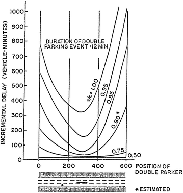
Illustration of delay caused by Double Parker. Source Reference [14]
-
Effective enforcement of parking and loading and loading restrictions.

6 Intersection Turn Controls and Management
Left and right turns impede traffic flow at many locations. The “right-turn problem” is usually critical in areas of heavy pedestrian activity commonly found in the city center and in older high-density neighborhoods.
Left turns, however, create intersection delays throughout the street system. They conflict with opposing through traffic, can also block vehicles behind them and complicate traffic signal phasing.
To reduce intersection delay many urban areas restrict left and right turns. These restrictions preserve capacity and reduce congestion, and can be in effect all day (7 a.m. to 7 p.m.) or just during rush hours.
Managing left and right turns at busy intersections by restriction or rerouting, is a long established and cost-effective way to reduce delays and congestion at busy intersections. Prohibiting left turns permits fewer phases, shorter cycle lengths, and longer “green times” for the through movement. This translates into more capacity and less delay.
6.1 Managing Right Turns
Right turn restrictions are sometime needed on intersection approaches where both right turns and pedestrian volumes are heavy. These restrictions result into shorter cycle lengths and reduce delays.
The travel times gained by restricting right turns can be estimated by applying the following equation [16]:
where
- ∆t:
-
green time to be gained per cycle
- r:
-
right turns/cycle (peak 15 min)
- p:
-
conflicting pedestrians per cycle (peak 15 min)
- t s :
-
time loss per pedestrian (e.g., 3–4 s), and
- L:
-
number of pedestrian channels in crosswalk
Using the above equation, the amount of time lost due to right turns and pedestrian conflicts can be estimated. The estimated times lost per signal cycle for a range of conflicting right turns and pedestrian volumes is shown in Table 16.4.
For example, if there are 300 pedestrians per hour conflicting with 240 right turns per hour (@ 60 cycles/h: 5 pedestrians and 4 right turns per cycle), and 3 s lost per conflict, about 20 s per cycle would be lost, assuming 3 pedestrian channels, or 20 = (4) × (5) × (3)/3.
Therefore, if right turns were prohibited in this case the curb lane would then gain an additional 20 s of additional green time per signal cycle.
Sometimes it is possible to provide curb lanes for moving traffic by removing curb parking, by restriping the roadway, or by minor widening.
6.2 Managing Left Turns
Delays from left turn movements (for right-hand driving) are common at intersections along most streets and roads. Depending upon specific circumstances, delays created by left turns generally can be reduced by prohibiting, better accommodating, diverting, or separating left turn movements. Table 16.5 summarizes the various ways of addressing the left turn issue and suggests where each possible improvement applies [5].
6.3 Left-Turn Treatment Options
This chapter describes how to minimize the left-turn conflicts at intersections through operational changes. While the next chapter describes how left turn conflicts can be separated through the redesign of the intersection.
-
(a)
Prohibiting Left Turns at Intersections
The prohibition of left turns is common at heavily traveled intersections, especially where it is not possible to provide protected left turn lanes. The prohibition simplifies traffic signal phasing, reduces queues, and improves traffic flow.
-
(b)
Allowing Left Turns at Intersections
Allowing left turns from a lanes used by through traffic (shared lanes), should be avoided along major roadways. Left turns from shared lanes can reduce lane capacity by about 50 %, increase delay to through vehicles, and increase the number of crashes. For these reasons, protected left turn lanes should be provided where space permits.
Sometimes left turn lanes can be provided by adjusting the center median, or by reducing the width of through lanes. Providing five 10-foot lanes on a 50 foot road out of four 12.5-foot lanes, would enable the extra lane to be used as a protected left turn lane.
Where left turn lanes are provided at signalized intersections, they are sometimes given a special phase. However, the green time provided for the left turns can both increases the cycle length and the delays to opposing through traffic.
Two-way left turn lanes are common in suburban settings where one finds roads with frequent driveways serving roadside development. Left turn lanes remove left turning vehicles from the through lanes and reduce delays to through traffic. Conventional left turn lanes are usually provided at signalized intersections in suburban areas.
6.3.1 Separating Conflicting Left Turns
Figure 16.3 shows a typical signalized access drive connecting to an arterial. Note that three signal phases are necessary.

Typical access design. Source Reference [5], p 76. Figure 8.18
Separating conflicting left-turn movements entering and leaving major developments along a roadway is generally desirable. The separation reduces intersection conflicts both along the public road and along the internal circulation roadways of the development. Figure 16.4 shows how separating the left turn movements entering and leaving a development site reduces conflicts and simplifies signal operation.

Directional access treatment. Source Reference [5], p 76. Figure 8.19
In this example, the left turn movements entering and exiting take place essentially at the same time. This two-phase operation results in shorter “red” times and less delay for motorists on both the arterial and site-access roads.
7 One Way Streets
One-way streets have improved traffic speed and reduced congestion since ancient times. They were found in Pompeii where the narrow lanes allowed for the passage of only one lane of vehicles [3].
In the US, one-way streets first emerged on Chestnut Street in Philadelphia and in the Park Row section of Manhattan in 1907. They were progressively implemented in American cities since the 1920s. By 1939, 85 % of the streets in Manhattan operated one-way. Most urban areas in the United States and Canada have one-way streets.
7.1 User Benefits
One-way streets are a low-cost strategy that reduces delay, increases traffic speeds, and improves safety. The delay reductions translate into lower emissions and better air quality. One-way street operations increase road capacity and reduce intersection conflicts, travel times and crashes. Case studies from the 1950s indicate that one way conversion from two-way traffic flow increased traffic speeds from 20 to 50 %, with a corresponding reduction in crashes [18, 19].
The changes in traffic volumes, trip times, and number of stops resulting from converting Fifth Avenue in Manhattan to one-way operation are as shown in Table 16.6.
The Madison Avenue-Fifth Avenue one-way couplet in Midtown Manhattan reduced accidents by 27 % and personal injuries 28 % [11].
7.2 Advantages of One-Way Operations
The reported advantages of one-way streets include the following:
-
a.
Reduced Conflicts at Intersections: Conflicts between through traffic and opposing left turns are eliminated, as is the need for special left-turn phases.
-
b.
Simplified Traffic Signal Phasing: Because the need for special left-turn phases is eliminated, cycle lengths can be shorter resulting in less “red times” and delays.
-
c.
Improved Traffic Signal Progression: Traffic signal offsets along a street can be set at the designed speed since only direction of travel is involved. The through band (or “green wave”) for one-way flow is usually greater than that for two-way flow because the green wave for both directions of travel is smaller. One-way traffic also simplifies signal coordination within a network.
-
d.
More Opportunities to Add Signals: Traffic signals can be added along a street without any adverse effect on the “through band” and progression.
-
e.
Safer Pedestrian Crossings: There are more traffic “gaps” acceptable to pedestrians since only one direction of travel is involved—making pedestrian crossings easier and safer.
-
f.
Safer Intersections: There are fewer traffic conflicts and eliminating the possibility of head-on collision improves safety.
-
g.
More Travel Lanes: Sometimes, one-way operations permit restriping a roadway to provide an additional travel lane.
7.3 Disadvantages of One-Way Operations
Several disadvantages have been cited for one-way streets. Disadvantages include:
-
a.
Longer Travel Distances: Some analysts have found that one-way streets increase the VMT by up to 30 % [20].
-
b.
Increase in Left Turn and Right Turn Volumes: The doubling up of left and right turns can increase pedestrian—vehicle conflicts. In areas of very heavy pedestrian volumes, and additional signal phase may be needed.
-
c.
Possible Confusion to Drivers: Confusion is greatest when drivers are not familiar with the one-way system and/or the system design is not easily understood by drivers.
-
d.
Longer Crossing Distances for Pedestrians: Where medians formerly separated opposing directions of travel, pedestrians have longer distances to walk when medians are removed for one-way operation.
-
e.
Reduce Store Front Exposure: One-way streets can adversely impact store front businesses that depend on pass-by traffic.
-
f.
Adverse Effects on Transit Riders: Transit service works best from a standpoint of passenger perception and identity when it operates in both directions on the same street. The adverse effects of one-way streets on transit service are greater when the one-way streets are far apart.
7.4 Applications of One-Way Streets
The use of one-way streets and roads was well expressed by Halsey [21] in his book “Traffic Accidents and Congestion,” in which he stated that one-way roads should be used wherever:
-
balanced pairs can be found
-
the revised routing does not unduly detour traffic too much, and
-
streets are too narrow to permit parking on each side, or to allow the effective movement of fire and other emergency vehicles.
7.5 Types of One-Way Streets
Within this context, the following types of one-way streets can be developed. Various details are provided in current and earlier editions of the Traffic Engineering Handbook [2].
-
Narrow streets that are usually less than 25 feet wide
-
Rotary movements around public parks or squares
-
Adjuncts or complements to freeway design—such as connections or extensions of freeway ramps or frontage roads that are parallel to the freeway
-
Simplification of complex intersections by making a minor street “outbound.” Simplification sometimes eliminates a traffic signal phase, allowing more green time added to the remaining two phases (see Fig. 16.5).
Fig. 16.5 
Making the minor street one-way simplifies a complex intersection
-
Along pairs of parallel arterial streets, such as: Chestnut Street and Walnut Street, Philadelphia; Broadway and Lincoln Ave., Denver; Washington and Warren Boulevards, Chicago; and most cross town streets and north-south avenues in Manhattan.

7.6 Installation Guidelines
The following guidelines underlie the installation of one-way streets:
-
One-way pairs should be comparable in width, capacity, continuity and land use
-
One-way pairs should be within 600 feet of each other wherever possible
-
Provide adequate transition to two-way traffic at the beginning and end of the one-way system
-
Provide conflict-free circulation around city blocks
-
Avoid interposing a two-way street between a one-way pair
-
Coordinate traffic signals along each street (or within a network) to provide progressive movements on common cycle lengths. Avoid long cycle lengths wherever possible
-
Manage conflicts between pedestrians and turning vehicles
-
Avoid street widths that exceed four moving lanes
-
Accommodate public transit service wherever possible
7.7 One-Way Toll Collection
One-way toll collection on approaches to bridges and tunnels and along toll roads with barrier tolls is a cost-effective way to reduce traffic delays (and the cost of toll collection). Examples of bridges and tunnels that collect tolls in one direction of travel include the Golden Gate and San Francisco Bay Bridges, on the Hudson River Crossings in the New York Metropolitan area.
8 Changeable Lane Assignments
“Changeable lanes assignments” is a term describing reversible lanes, roads and ramps that provide cost-effective means of accommodating the tidal variations in traffic flow. Changeable lane assignments can reduce delay with a minimum implementation costs. They usually apply to all vehicles, although sometimes they apply just to priority vehicles (e.g., buses, taxis, carpools).
8.1 Benefits from Applications
This strategy has the potential to achieve significant delay reductions where traffic flows are highly unbalanced. Its implementation can benefit from applications of automated traffic control technologies such as sensors and lane control signals. Delays can be minimized when left turns are prohibited along arterial streets during the hours that the reversible lanes operate.
-
Reversible lanes provide an effective means of accommodating tidal variations in traffic flow on roadways connecting the city center or other major activity center with residential areas. Capacity increases in the peak direction of 20–50 % have been reported—with corresponding reductions in travel time. Accident reductions up to 30 % have been reported; however, they probably reflect the drop in congestion-related rear end crashes [22].
-
Application of this strategy along Memorial Drive in Atlanta, GA showed that peak travel times in the major-flow direction decreased by 25 % in the am peak, and 24 % in the pm peak [23]
-
Reversible lanes along 6 miles of 7th Ave. in Phoenix AZ, increased speeds about 25 % in the AM peak period and 16 % in the PM peak period, but there was a 28 % increase in crashes. The annual cost of crashes and sign installation was $175,000, while the annual travel time savings were valued at about $1,000,000 [18].
Table 16.7 illustrates how the per lane demand-to-capacity ratio of a four-lane, 2-way street can be better balanced through reversible lane operations of lane #3.
8.2 Types and Extent of Applications
Reversible lanes are generally applied along radial arterial streets and freeways. They are also used at many bridges/tunnels and toll plazas. Sometimes entire streets are made reversible.
A 2006 survey for the ITS Deployment Database, 8 of 100 metro areas reported using reversible lanes on 98 miles of freeways, representing one percent coverage [23]. And 16 of 106 metro areas reported using reversible lanes on only 126 miles of arterial streets. Considerable mileage was found in two metro areas (Fresno CA, and Janesville-Beloit, WI). Other applications of this strategy were found in several freeway bridges/tunnels (e.g., Bay Bridge in San Francisco, Walt Whitman Bridge in Philadelphia, Tappan Zee Bridge in Westchester-Rockland counties, NY, the Long Island Expressway approach to the Queens Midtown Tunnel (NYC), and the Gowanus Expressway Approach to the Brooklyn Battery Tunnel (NYC).
Examples of reversible lanes include:
-
I-5, Seattle
-
the JFK Expressway, Chicago
-
Connecticut Avenue, Washington, DC
-
Highland Boulevard, Los Angeles
-
North Sheridan Road, Chicago
8.3 Strength and Weaknesses
The basic strength of reversible lanes is their ability to serve both directions of travel. In so doing, they reduce congestion by providing a better balance between demand and capacity at a relatively little cost. A possible weakness of reversible lanes is an increase in the number of crashes (especially if left turns are permitted). Therefore, roadways with reversible lanes work best when left turns are banned.
8.4 Application Guidelines
Reversible lanes are appropriate where [24]:
-
There are pronounced imbalances in the directional traffic volume. The ratio of major to minor movement should be at least 2–1.
-
Peak period and peak direction flows are recurrent.
-
Peak hour traffic speeds generally are at least 25 % slower than those during the off-peak period.
-
Adequate provisions are made to accommodate the traffic in the corridor.
-
Adequate capacity is provided at the transitions of the beginning and end points, and parking should be prohibited during the hours that the lanes are in effect.
-
Reversible lanes work best when left turns are prohibited at signalized intersections. They are not compatible with the provision of protected left-turn lanes, and they do not work well on streets with median islands.
Reversible lanes on streets can be controlled in various ways:
-
Using both curb-mounted and overhead signs are used.
-
Overhead lane control signals that conform to the National Manual on Uniform Traffic Control Devices [3].
-
Traffic cones and portable barriers.
-
Movable physical barriers are typically used on bridges and on freeways.
A common practice is to use physically separated roadways on freeways and to control entry by electronically operate gates. Implementation of reversible flow lanes is applicable for freeways and arterial streets with automated lane control technologies (sensors and lane control signs).
9 Ramp Controls
Ramp meters and entrance controls are integral parts of many freeway management programs. They control the rate at which ramp vehicles enter the freeway during peak periods to prevent a speed reduction and a lower volume throughput of the freeway lanes. Metering is most effective when the freeway operates at service levels of “E” or “F”.
9.1 Applications
Ramp controls work best when the following conditions apply [25]:
-
recurring peak period traffic congestion along the freeway (e.g., demand exceeds capacity)
-
there are suitable alternative surface routes that can accommodate traffic diverted by the metering strategy (e.g., available continuous frontage road along the freeway)
-
the travel time saved by the freeway traffic exceeds the additional delay that diverted traffic imposes on surface routes
-
adequate ramp storage for vehicles waiting to enter the freeway (to avoid spillback onto surface streets)
9.2 Control Types and Methods
There are several ways to apply entrance ramp controls. Methods include:
-
(a)
permanent or part-time closure
-
(b)
pre-timed or traffic responsive ramp metering
-
(c)
traffic responsive merge control
-
(d)
integrated system controls that apply to a series of entry ramps along the freeway
Metered freeway ramps that operate in a single lane should have a full width shoulder to allow for emergency passing. A common practice is for buses and car pools to bypass the ramp controls. In these cases an additional full-width bypass lane should be provided [2, 26].
9.3 Benefits
Typical benefits reported from freeway ramp metering include [23]:
-
in the Minneapolis-St. Paul region system-wide ramp metering has increased freeway throughput volume by 30 % and peak period speeds by 60 %, with travel time decreases of 14–27 %
-
ramp metering along freeway corridors in other cities have found that freeway travel times decreased by 7 % (Portland, Detroit), 27 % (Denver), 38 % (Austin), and 48 % (Seattle).
-
ramp metering, however, creates queues at entry ramps, that can cause traffic to divert to local streets, resulting in increased delay on local streets.
-
in Minneapolis-St. Paul, however, when the ramp delays were included, the total delay was still substantially reduced.
10 Access Management
Access management is a proactive strategy that balances the need to minimize traffic delay and crashes along arterial roadways with the need to provide access to land development activities adjacent to the roadway. It applies to both existing and new roadways. It extends the concept of access control to these roads by defining access spacing standards, providing suitable geometry, and establishing the necessary legislative authority to implement the desired standards.
The primary goals of access management are to improve safety and to maintain desirable traffic speed and capacity along arterial roads and streets. These goals are achieved by coordinating and consolidating the number and location of curb cuts to adjacent land development, and by controlling the spacing of traffic signals along arterial roads. As noted earlier, each traffic signal per mile added to the roadway reduces speed about 2–3 mph.
There is a large repertory of access management techniques [7] including: separating and physically restricting left turns; restricting curb cuts and direct access to driveways; establishing access spacing requirements; separating obvious conflict areas; eliminating parking along roadway; constructing frontage roads to serve local business traffic and enhancing nearby intersections. NCHRP Report 420, Impact and Access Management Techniques provides a comprehensive list and assessment of these techniques [4]. The Access Management Manual [27] gives further guidance on the use and benefits of access management in traffic operations.
10.1 Basic Principles
Several basic principles underlie access management as a strategy for reducing congestion and improving traffic safety. They are briefly described below:
-
Limit (or prohibit) direct property access along higher type roads
-
Provide a specialized roadway system in which different roads serve different travelers and goods movement needs relative to accessibility and mobility. Figure 16.6 shows an example of the hierarchy—freeways emphasize high speed travel and are designed with complete control of access (to the freeway); local roads emphasize low speed movement whose functions are designed to provide access to land and buildings; while arterials must serve both movement and property access.
Fig. 16.6 
Functions and access control of various road types. Source Reference [5], p 50. Figure 6.1
-
Preserve traffic signal coordination—locate signals only where they fit in the traffic signal coordination plan
-
Locate access drives away from intersections in order to minimize traffic conflicts and crashes

10.2 Access Control Methods
Access control is mainly implemented through the police power of eminent domain. It also can be achieved through the geometric design of roadways and access connections to land uses. The development of an access classification system (e.g., Fig. 16.6) can prove useful in determining when, where, and how access can be provided.
10.3 Access Design Concepts
Access planning and design should coordinate the three aspects of the access system—the public roadway, private driveway, and private development requirements/needs. All three should be treated as an integral part of the overall access system. In this way access can be provided and congestion minimized.
Road connections to land developments should have adequate turning radius and storage space. The conditions, shown in Fig. 16.7 (top) should be avoided. But, unfortunately, the problem of inadequate throat length is found along many roads.

Driveway improvements to increase storage. Source Reference [5], p 86. Figure 8.31
Where it exists, this condition can (and should) be corrected by increasing storage space on the connecting driveway, and by separating the left turns into and out of the development. Figure 16.7 (bottom) shows that by increasing the storage space and by separating conflicting left-turn access, conflicts are greatly reduced and congestion can be reduced or eliminated. Additional examples of best access practices are given in [5].
10.4 Traffic Speed and Safety Impacts of Access Management Practices
The effects of access and traffic signal frequency on traffic speeds have been well documented.
-
The 1994 Highway Capacity Manual [28] reported a speed reduction of 0.24 mph for every access point along unsignalized highways, and up to a 10 mph speed reduction for sections with 40 or more access points
-
Each traffic signal per mile added along an arterial roadway reduces traffic speed by about 2–3 mph
-
The application of access management techniques has resulted in significant safety and level of service improvements, as shown in Table 16.8 [29].
Table 16.8 Summary of research on the effects of access management techniques -
Table 16.9 summarizes access management benefits in traffic speeds and safety from eight case studies. Speeds and safety improved at each location.
Table 16.9 Summary of access management benefits reported in the case studies
10.5 Conclusions
It is clear that access management is a desirable strategy from a congestion-reduction perspective. A growing number of state and local transportation agencies have implemented access management activities. However, others have not. This is because “controlling or managing access along arterials is a difficult task facing local officials and transportation engineers. This difficulty comes from a time-honored tradition, and in some cases a legal right, for land owners abutting a road to have access to their land” [7].
However, there is a growing recognition of the importance of access management in congestion mitigation, and of the need to better integrate access management with corridor traffic management and land development. Development density and design, which greatly influence levels of transit service and pedestrian access, will likely receive more emphasis in the future, as the “green” goal of VMT reduction is increasingly gaining popularity.
11 Emerging Congestion Management Strategies
Application of new detection, information, and communications technologies in transportation increases efficiency of the system and provide better levels of service for travelers in terms of lower traffic congestion, reduced delays, and safer roads. The application of these advanced technologies in transportation is popularly known as “Intelligent Transportation Systems,” or ITS.
11.1 Intelligent Transportation Systems (ITS)
ITS strategies entail use of real-time traffic information that allows dynamic traffic signal controls, better traveler information, roadside electronic screening programs, integrated corridor management, and vehicle-infrastructure integration (VII).
Examples of these strategies are described below:
-
ITS traffic control strategies include a range of applications, including metering traffic, dynamic timing of traffic signals in response to changing traffic demands, non-stop toll collection, metering flow entering the freeway, managing the response to traffic incidents, or providing real time information to travelers about traffic delays, expected travel times, and alternative routes/modes.
-
Traveler Information Systems—provide travelers with real-time accurate information on roadway traffic congestion and advice on alternative routes if any are available. Real time traffic information reduces trip delays and increases mobility. Various types of traveler information are available in US cities. They include: traffic radio reports, “511” traveler information numbers, on-route Dynamic Message Signs (DMS) posting expected travel time, and through private providers such as NavTeq/Traffic.com and INRIX. The increasing popularity of “smart phones” provides extensive access to real time traffic information—generally for a fee.
-
Roadside Electronic Screening/Clearance Programs for Commercial Vehicles: These actions enable credentialed motor carriers to bypass weigh stations. This reduces the volume of trucks at weigh stations and the delay time while being processed in addition to the time spent in queues waiting to be processed. It also can eliminate queues upstream of weigh stations that create mainline congestion and safety hazards.
• In Oregon, the “Green Light Commercial Vehicle Operations (CVO)” project was expected to prescreen 7.2 million trucks between 2002 and 2012, and save 360,000 h and $25 million to the trucking industry [23].
• The Pre-Pass system is a transponder-based electronic system that enables enrolled trucks to bypass weigh stations that have been retrofitted with Pre-Pass infrastructure: provided to the states free of charge but paid for by participating motor carriers who fund the system with monthly service charges. In 2011, the Pre-Pass system handled approximately 50 million trucks for an aggregate saving of over 4 million hours and over $433 million (http://www.prepass.com).
11.2 Integrated Corridor Management (ICM)/Active Traffic Management (ATDM)
Integrated Coordinated Management (ICM) of traffic controls, lane assignments, traveler information, comprises a series of strategies (e.g., traffic sensors, traffic management centers, managed lanes, rapid incident response) to dynamically manage roadways and corridors in response to recurring and non-recurring sources of congestion.
-
ICM is a relatively new concept. The US Department of Transportation has implemented eight demonstration projects across the US.
-
ICM is a relatively new concept. The US Department of Transportation has implemented eight demonstration projects across the US. An example of the successful application of this approach has been achieved in the metropolitan areas of Dallas (Route 75), Alameda and Contra Costa Counties in northern California (I-80), San Diego (I15), and Seattle (I-5) [31].
-
it is anticipated that congestion relief benefits from the ICM strategy will be greater than the benefits of individually applied strategies as demonstrated by the application of a similar approach in Europe (Active Traffic Management) that uses:
-
Speed harmonization: reducing speeds in advance of a major bottleneck to minimize the impact of the congestion event and increase overall throughput;
-
Temporary shoulder use: using the shoulder of the roadway in conjunction with speed harmonization, to increase capacity during peak periods;
-
Queue warning display systems: to warn drivers of the presence of congestion downstream;
-
Dynamic merge control: the selective closing or metering of ramps based on traffic demand to maximize throughput, with priority given ramps with higher volume;
-
Dynamic routing and traveler information: the use of dynamic message signs to display rerouting instructions in response to non-recurring congestion events; and
-
Dynamic lane markings: the delineation of lanes to manage traffic flow patterns created by the above strategies.
-
Transit-Traffic Integration: the coordination of transit and traffic operations in both arterial streets and freeway corridors to reduce delay for all travelers.
-
12 Conclusions
The various operational (e.g., traffic engineering) strategies described in this chapter, where effectively and sensibly applied, will reduce congestion delays in most urban areas.
A general description of various strategies, and an assessment of their application, effectiveness, and implementation issues is given in Table 16.10. This table is adapted from a national research project conducted by Cambridge Systematics [23].
The resulting benefits of operational strategies that reduce recurring congestion, however, will probably not meet the long term needs of many cities. Growth in person travel—motorized travel in particular—in the rapid growing areas of the United States will require additional congestion relief strategies and actions. Accordingly, Chap. 17 describes roadway capacity expansion strategies and Chaps. 18–23 describe strategies that reduce traffic demand.
References
Highway Capacity Manual. Transportation Research, Washington, DC (2010)
Traffic Engineering Handbook. Institute of Transportation Engineers, Washington, DC
Manual of Uniform Traffic Control Devices for Streets and Highways, 2009 Edition with Revision 1 and 2. s.l.: US Department of Transportation, Federal Highway Administration (2012)
Gluck J, Levinson HS, Stower V (1999) NCHRP Report 420: impacts of access management techniques. Transportation Research Board, Washingto DC
Koepke FJ, Levinson HS (1992) NCHRP Report 348: access management guidelines for activity centers. Transportation Research Board, Washington, DC
Sunkan S (2004) The benefits of retiming traffic signals. ITE Journal. April 2004.
Meyer MD (1997) A toolbox for alleviating traffic congestion and enhancing mobility. Institute of Transportation Engineers, Washington, DC
Levinson HS, Cleveland DE, Kostyniuk LP, Waissi GR (1985) Traffic engineering for public transportation—a manual for practice draft 1985
Levinson HS, Mentor I (2005) Operational improvements—an overview. s.l.: UTRC2 Research News
Homburger WS, Hall JW, Loutzenheiser NC, Reilly WR (1995) Fundamentals of traffic engineering, 14th edn. Course notes. University of California, Berkeley
Bruce JA (1967) One-way major arterial streets. Highway Research Board Special Report: improved street utilization through traffic engineering, pp 24–36
Falcocchio JC, Jose D, Prassas ES (1995) An inquiry on the traffic congestion impacts of parking and pricing policies in the Manhattan, CBD. s.l.: prepared for New York City Department of Transportation and the University Transportation Research Center, Region 2
Shoup D (2005) The high cost of free parking. s.l.: American Planning Association
New York City Department of Transportation (2013) Measuring the street: new metrics for 21st century streets
Polytechnic Institute of New York (1975) NCHRP Report 3-18(2) traffic control in over saturated street network. Transportation Research Board, Washington, DC
Kittelson & Associates, Inc., Herbert S. Levinson Transportation Consultants, DMJM + Harris (2007) TCRP Report 118, bus rapid transit practitioner’s guide. Transportation Research Board, Washington, DC
Levinson HS, Zimmerman S, Clinger J, Gast J, Rutherford S, Bruhn E (2003) TCRP Report 90: bus rapid transit. Volume 2: implementation guidelines. Transportation Research Board, Washington, DC
Homburger WS, Hall IW, Luotzenhouser RC, Reck WR (1996) Fundamentals of traffic engineering. Institute of Transportation Studies, Berkeley
Matson TM, Smith WS, Hurd FW (1951) Traffic engineering. McGraw-Hill Book Company, New York
Walker GW, Kulash WM, McHugh BT (2000) Downtown streets—are strangling ourselves on one-way networks? In: Transportation research circular E-C019: urban street symposium conference proceedings, Dec 2000, p F-2
Halsey M (1941) Traffic accidents and congestion. Wiley, New York, p 315
LaPlante JN (1967) Directional flow improvements on urban streets. Highway Research Board Special Report 93: improved street utilization through traffic engineering, pp 17–23
Prepared by: Cambridge Systematics and Resource Systems Group (2008) NCHRP 20-24A Task 63: effective management practices for congestion management: final report. Requested by: American Association of State Highway and Transportation Officials (AASHTO), Washington, DC, Nov 2008
Titus LT (1976) Speed regulations and other operational controls. Transportation and traffic engineering handbook, Chapter 18. Prentice Hall, Englewood Cliffs
Capelle DG, Bau S (1987) Transportation and traffic engineering handbook, 2nd edn. Chapter 25: freeway surveillance and control. Prentice Hall, Englewood Cliffs
Freeway Management Handbook. s.l.: Federal Highway Administration, US Department of Transportation, Report No. FHWA-SA-97-064, August 1997
Committee on Access Management (2003) Access management manual. Transportation Research Board, Washington, DC
Highway Capacity Manual. Transportation Research Board, Washington, DC (1994)
SK Transportation Consultants Inc. (2000) Access management location and design: participant notebook for NH Course 133078. s.l.: National Highway Institute, Federal Highway Administration
Levinson HS, Koepke FJ (1993) Case studies in access management. s.l.: Prepared for Transportation Research Board
O’Connor AT (2014) Development of a framework for the deployment of intelligent transportation systems in a multi-agency environment. Ph.D. dissertation, s.l.: NYU Polytechnic School of Engineering, May 2014
Author information
Authors and Affiliations
Corresponding author
Rights and permissions
Copyright information
© 2015 Springer International Publishing Switzerland
About this chapter
Cite this chapter
Falcocchio, J.C., Levinson, H.S. (2015). Adaptation Strategies for Managing Recurring Congestion—Operational Improvements. In: Road Traffic Congestion: A Concise Guide. Springer Tracts on Transportation and Traffic, vol 7. Springer, Cham. https://doi.org/10.1007/978-3-319-15165-6_16
Download citation
DOI: https://doi.org/10.1007/978-3-319-15165-6_16
Published:
Publisher Name: Springer, Cham
Print ISBN: 978-3-319-15164-9
Online ISBN: 978-3-319-15165-6
eBook Packages: EngineeringEngineering (R0)