
Abstract

Access provided by Autonomous University of Puebla. Download chapter PDF
14.1 Introduction
Covering 71% of Earth’s surface, and making up 97% of the water on Earth, the sheer scale and size of oceans on Earth underline their importance to the evolution of our planet. Oceans probably formed on Earth as soon as its surface was cool enough for liquid water to exist. In geological terms, modern oceans are ‘born’ and subducted within 200–300 million year lifecycles. The world’s oceans, seas and coastal areas are critical to sustainable development, helping to advance social and economic development (Halpern et al. 2012). For example:
-
Oceans are complex ecosystems hosting significant biodiversity, with careful management needed to reduce pollution of all kinds. This biodiversity is not surprising given the geological and geomorphological diversity shown in ocean seascapes. This includes trenches with depths of almost 11 km, around 80,000 km of mid-ocean ridges, mountains, seamounts, ocean islands, and ocean plateaus, island arc systems, and voluminous abyssal plains some 4 km beneath sea level.
-
Oceans play a critical role in climate, absorbing heat and carbon dioxide from the atmosphere. Approximately one-third of the carbon dioxide released into the atmosphere by human activity has been dissolved into oceans (Sabine et al. 2004), contributing to the problem of ocean acidification.
-
Coastal and marine environments (Fig. 14.1) add approximately US$2.5 trillion to the global economy each year, when considering tangible outputs including fishing, shipping traffic, and carbon absorption (Hoegh-Guldberg 2015), estimates that the overall ecosystem services provided by coastal and marine resources contribute US$28 trillion to the global economy each year (United Nations 2016).
Fig. 14.1 
Image by David Mark from Pixabay
Indian Ocean (Maldives). Key economic sectors in the Maldives rely on access to coastal and marine environments, including fisheries, tourism, shipping, and boat building.
-
Oceans provide livelihoods and opportunities for billions in coastal communities. The UN estimates that over three billion people depend on marine and coastal resources for their livelihoods, including fishing and tourism (United Nations 48,61,).
-
Oceans provide food, with total fish production in 2016 (including both inland and marine sources) of 171 million tonnes, with 88% of this for direct human consumption (FAO 2018). 63% of this 171 million tonnes are from marine sources.
-
Access to oceans is needed to extract a range of energy and mineral resources including oil, gas, gas hydrates, aggregates and construction materials, and seabed minerals (including rare earth elements, gold, copper, and silver).

Delivering SDG 14 is therefore necessary if we are to deliver many other SDGs, including reducing the vulnerability of the world’s poorest communities (SDG 1.5), reducing hunger through access to nutritious proteins (SDGs 2.1 and 2.3), promoting sustained, inclusive and sustainable economic growth and employment (SDG 8), and strengthening resilience to climate-related hazards (SDG 13.1). Protecting oceans from degradation is therefore of primary importance, as is the responsible harvesting of living and non-living resources. Sea-level rise threatens entire coastal communities, and even countries, increasing their vulnerability to flooding (Wahl 2017). Ocean acidification, due to increased absorption of carbon dioxide in seawater, is making it harder for ocean species (e.g., oysters, and corals) to develop carbonate shells and structures (NOAA 2019a), and therefore poses a threat to both jobs and food security. Warmer oceans are also associated with reductions in some fish stocks. Sea-surface temperatures have risen by 0.7 °C over the last 100–130 years, with this projected to increase to 1.2–3.2 °C by 2100 due to greenhouse gas emissions. This may change the geographic regions where aquaculture of some species is viable, and lead to a decline in cold-water fish species.
Table 14.1 outlines seven targets and three means of implementation relating to SDG 14. These include ambitions to address marine pollution, restore marine environments, and improve the management of ocean resources. This chapter examines how geoscientists can help to deliver these targets, with an emphasis on Small-Island Developing States (commonly abbreviated to SIDS) in the Pacific. SIDS have significant and challenging development issues (e.g., resilience to climate change and natural hazards) and opportunities (e.g., renewable energy and sustainable tourism). They give us a valuable perspective on the health of the oceans and coastal regions, with opportunities for geoscientists to contribute to ocean conservation and restoration. The lessons we present here, however, have broader relevance. Coastal areas in countries such as the United Kingdom are associated with deprivation due to a decline in industries such as tourism (House of Lords 2019), and in other contexts, easy access to the ocean is a key driver of urban development with associated pollution challenges. The future of the oceans therefore has relevance for communities across the globe.
In this chapter, we first describe diverse coastal communities, but with a particular emphasis on Small Island Developing States (or SIDS, Table 14.2), their distribution, development challenges, and the geological processes that determine their existence (Sect. 14.2). We proceed to explore the role of geoscientists in protecting such marine environments (Sect. 14.3), highlighting sources of pollution with a geological origin and geoscience activities to identify, monitor, and reduce potential pollution to marine environments. We then explore the diverse and valuable ocean resources that drive sustainable development (Sect. 14.4). The final section synthesises key lessons to increase scientific knowledge, develop research capacity, and transfer marine technology for ocean management (Sect. 14.5).
14.2 Coastal Environments, Small Island Developing States, and Sustainable Development
Coastal communities take many forms, with both general and location-specific sustainability challenges. Communities include rural areas with low population density, agriculture and small-scale fishing, and urban areas (including megacities) with high population density, busy ports, and heavy industry. Coastal communities may form a small part of one nation (e.g., approximately 3 million out of 60 million people (5%) live on the coast of the United Kingdom), or the entire population of a nation. Small Island Developing States, or SIDS, consist of one or more small islands, or island groups, forming archipelago countries or overseas territories. For example, the Solomon Islands include more than 900 islands, and Vanuatu consists of at least 82 islands. While each individual island typically has a small land area, the total land and marine territory attributed to any individual nation can be large.
The Pacific islands region, with 22 countries and territories, covers an area approximately the same size as Africa, around 300 million km2. Papua New Guinea is the only ‘Pacific Island’ to have a large land area, being around the same size as France. The remaining countries have a cumulative land area of approximately 85,000 km2, or the same size as Austria, within an ocean area close to the size of Africa. They are also, therefore, large ocean states, some with Exclusive Economic Zones (areas of sea where a state has special rights regarding marine resources, illustrated in Fig. 14.2) of enormous dimensions. A classic example is Cook Islands with around 200 km2 of land and 2 million km2 of the ocean (Petterson and Tawake 2016, 2018). Papua New Guinea has a population of approximately 8.5 million people, with other Pacific SIDS having populations between approximately 900,000 (Fiji) and 10,000 (Tuvalu).

Credit Maximilian Dörrbecker, CC BY-SA 2.5 (https://creativecommons.org/licenses/by-sa/2.5/)
Exclusive Economic Zones in the Pacific Ocean.
In geological terms, SIDS include ocean structures such as island arcs, atolls, raised or obducted parts of the oceanic crust that are currently situated above sea level, and rifted pieces of continental crust. Oceanic island arcs form from the subduction of oceanic crust beneath other oceanic crust, whilst seamounts and ocean plateaus form from mantle plumes. SIDS are given special attention in development discussions because of a set of shared characteristics including small land area, remote geographic locations, limited economic development opportunities, and enhanced vulnerability to disaster and risk. SIDS also create some unique opportunities for sustainable development. Issues of relevance include
-
Energy. A lack of reliable and sufficient power has constrained development within many SIDS. Many SIDS have a large dependency on (mostly imported) oil for a relatively small amount of electricity generation. In some Pacific island small states (e.g., Papua New Guinea, Vanuatu, and Solomon Islands), large proportions of the population do not have access to electricity, with the exception of local diesel generators or solar energy. Access to solar-powered batteries is rapidly increasing, and this is mitigating energy-poverty for some. Increasing use of renewable technologies, including new ocean energy technologies, could bring greatly improved, reliable, and increased output to provide a renewed basis for future economic and social development. Cheaper and more reliable energy production could help to achieve additional SDGs including improving food and water security, and enhanced employment opportunities.
-
Water and Sanitation. Many SIDS, particularly small atoll-SIDS, can rely on fragile freshwater lenses that sit on top of the denser saline ocean, rainwater harvesting, and expensive desalination that requires large amounts of energy. While the mortality rate attributed to unsafe water, unsafe sanitation, and lack of hygiene (per 100,000 population in 2016, with data from World Bank, 2019a) for Pacific island small states (5.2) is significantly below that of the Least Developed Countries (34.3) and even the world average (11.8), it is still more than 17 times higher than the European Union (0.3). Atoll small islands may experience extended times of drought, which bring severe water stress. Tuvalu, for example, experienced a La Niña-influenced drought, lasting five months in 2011. This required water to be brought by ship from Australia, New Zealand, and elsewhere.
-
Food Security. In the Caribbean, 1 in 5 people is undernourished, compared to less than 1 in 20 people in neighbouring Latin America (United Nations 2015). The prevalence of undernourishment (% of the population in 2017, with data from World Bank 2019b) for Pacific island small states (5.6%) is significantly below that of the Least Developed Countries (23%) and even the world average (11%), but more than twice that of the European Union and North America (2.5%). Some islands within SIDS, and particularly within atolls have limited soil and land resources. Their soils are sandy, lack organic material, and are saline, reducing the potential for diverse agriculture.
-
Economic Growth and Livelihoods. SIDS are typically small, remote, have a narrow resource and export base, and have a high exposure to external economic shocks. Given their large exclusive economic zones, there may be new opportunities and livelihoods through seabed mining. This would need to be managed in such a way so as to minimise environmental damage and maximise wealth return for the national good. The creation of marine parks and reserves, with geoscience as an integral part of their design to take account of issues such as the geology of the ocean floor, and the range of ocean landscapes could also provide economic, social and environmental benefits.
-
Environmental Protection. SIDS have a high exposure to global environmental challenges including climate change and natural hazards. SIDS crystallise environmental change issues in an acute manner, often capturing global attention because of their susceptibility to climate change impacts, including rising sea levels. The small size of many SIDS necessarily leads to high percentages of island populations and infrastructure being impacted by a single disaster event. Cyclone Pam in 2015, for example, had an economic impact in Vanuatu equivalent to 64% of the value of the national economy (ILO 2015). Many SIDS are atolls, which are low lying islands, only a metre or several metres above sea level. They are largely formed of sand and broken coral limestone clasts of varying sizes, that are deposited, and cemented, upon a slowly subsiding ocean island volcano. In plan view they are circular to sub-circular in shape reflecting the geomorphology of the uppermost subsiding volcanic edifice. Atolls enclose an inner shallow lagoon on one side but drop off steeply to open ocean on their outer side. Atoll islands tend to be long and narrow and can form a number of widespread discrete archipelago units within one country or territory. A sea-level rise of a few metres over a short space of time could lead to the inundation of these islands, threatening their existence and entire (unique) cultures. Even relatively small sea-level rises increase the impact of the largest spring tides (so-called ‘King Tides’) on atoll islands. Pacific atolls have a combined population of approximately 200,000 people. The Maldives, the world’s most populous atoll country in the Indian Ocean, has a population of approximately 436,000. When considering a global population of 7.6 billion, atoll peoples thus represent distinct cultural centres.
Fig. 14.3 
A typical atoll: Gilbert islands, Kiribati. Note the annular island geometry, the low-lying nature of the islands, and the thin nature of most islands (© Michael G. Petterson)

We return to some of these themes later in this chapter, exploring how geoscience understanding and engagement can provide solutions to challenges and maximise the benefits of potential opportunities.
Box 14.1. History of Settlement in Pacific Atolls
For around 4000 years, Micronesia (the atoll islands of the Pacific, Nauru, Marshall Islands, Federated States of Micronesia, Kiribati, and Tokelau) and Polynesia (Samoa, Tonga, Tuvalu, and Cook Islands) have been populated (Irwin 1998; Dickinson 2009). Humans have survived and colonised a widely dispersed series of sand- and coral-dominated islands and islets across millions of square kilometres of theocean. For the great majority of this history, humans have existed on fragile freshwater lenses that form as a lower density layer, sitting on top of ocean water, within atolls, supplemented by rainwater capture. They have eaten a diet largely comprising seafood, added to from sparse land agricultural produce such as coconuts, breadfruit, and slow-growing, salt-resistant taro. Materials for shelter and sailing were entirely supplied from local bush materials.
Perhaps more than any other people, atoll people are ocean people. The history of the settlement of the many scattered islands and archipelagos is a testament to the close oceanic affinity. Countless ocean-going journeys into the unknown involving thousands of indigenous peoples from areas such as Taiwan, China, Malaysia, and India resulted in the Pacific islands such as Papua New Guinea and Solomon Islands becoming occupied from approximately 50,000 years ago, and the Micronesian and Polynesian islands from c. 4000 years ago (Irwin 1998).
The people of the Pacific are thus rooted in the ocean. Their history and various lifestyles have adapted to, and been influenced by, the ocean. This is best appreciated standing on a low-level atoll, less than a metre above mean sea level, watching life around as the tide rises and falls. The atoll island may be only tens or hundreds of metres wide. It is often hard to define where the ocean ends and land begins with the rising and falling tides.
14.3 Protecting Marine Environments
Fundamental to the ambitions of SDG 14 is protecting marine environments. For example, Target 14.1 focuses on reducing marine pollution, 14.2 on protecting marine and coastal ecosystems to achieve healthy and productive oceans, and 14.3 on addressing the impacts of ocean acidification. Coastal and marine environments are affected by a range of environmental stresses, and understanding these is critical to ensuring a sustainable future for oceans. This requires interdisciplinary marine science (Government Office for Science 2018), including those with geological expertise. In this section, we set out three broad environmental challenges facing the oceans, and the role of geoscientists in understanding and managing these: marine pollution (Sect. 14.3.1), sea-level rise (Sect. 14.3.2), and ocean acidification (Sect. 14.3.3).
14.3.1 Marine Pollution and Sustainable Development
Beiras (2018, p. 3) note marine pollution to be ‘the introduction of substances or energy from humans into the marine environment, resulting in such deleterious effects as harm to living resources, hazards to human health, hindrance to marine activities, including fishing, impairment of quality for use of seawater, and reduction of amenities’. Marine pollution includes a wide range of substances from human activities including toxic chemicals, pharmaceutical products, metals, gases, solid wastes, plastics, increased nutrients (e.g., from agricultural runoff into the ocean), sewage, ocean ship discharges, oil spills, and fishing nets. Of these, oil pollution is an example of a substance with an extractive industrial origin, and plastic is a tracer for how widespread and pervasive human pollution within the ocean environment has become.
Global oil production, in 2018, was around 2.2 million barrels per day, or 4700 million tonnes equivalent annually, up from 4000 million tonnes in 1993 (BP, 2019). Of this, around one-third is extracted from strata beneath the ocean and coastal waters. Just under two-thirds of all oil produced is transported by sea. Oil spills have numerous causes, from leaking ships, oil tanker accidents, to oil platform blowouts. One of the worst incidents of modern times was the BP-owned Deepwater Horizon blowout incident that occurred on 20 April 2010, in the Gulf of Mexico, with a total discharge of 4.9 million barrels of oil. The incident killed eleven oil platform workers and produced an oil spill that affected 180,000 km2 of ocean, or a similar size to Oklahoma or Cambodia, as well as thousands of kilometres of coastline. Managing this environmental catastrophe involved dispersal, containment, and removal activities, involving 47,000 people and 7000 vessels (Liu et al. 2011). The impacts of oil pollution are numerous and particularly distressing to marine and coastal wildlife. For example, oil can destroy the insulating ability of fur-bearing mammals, the water repellence of birds’ feathers, and be ingested by shellfish, fish, cetaceans, birds, and other marine wildlife (NOAA 2019b).
Considering the huge volumes of oil that are extracted from, or transported, through the oceans, there are relatively few large-scale oil-related environmental pollution incidents. Roser (2019) notes a decreasing number of oil spills from tankers between 1976 and 2016, averaging 1.7 large (>700 tonnes of oil) spills in the 2010s. There is no room for complacency, however, given the significant impact even small spills can have on ecosystems.
Another pollutant, plastics, are a key indicator of the Anthropocene, a proposed epoch where the activities of humans are the dominating influence on Earth’s systems (see Waters et al. 2016). Plastics are particularly useful ‘tracer’ materials for the global impact and reach of human industrialisation. Geyer et al. (2017) estimate that, historically, 8300 million metric tonnes (Mt) of plastic were produced up to 2015, of which 79% have been accumulated in landfills or the natural environment, with every indication that these figures are set to increase. Plastic production has exponentially increased from the 1950s and shows few signs of slowing down. The sheer scale and extent of plastic pollution, from the deepest oceans, to the ocean surface, and many terrestrial environments is a particularly sobering and instructive story of the human impact on the planet, including oceans and marine life (Fig. 14.4).

Reproduced under a CC-BY-SA Licence (https://creativecommons.org/licenses/by-sa/2.0/)
Cartoon illustration of plastic production and resultant waste streams, and potential paths of a range of plastic waste streams. The oceans, being the largest basins on Earth and covering 71% of the Earth’s surface, have a high probability of becoming the final repository of plastic waste. Image by Ritchie and Roser (2018), using data from Jambeck et al. (2015) and Eriksen et al. (2014).
Ocean gyres are large areas where ocean currents concentrate plastic, either at or close to the ocean surface. All oceans have examples of these plastic-concentration zones. The characteristic that makes plastics so useful (their durability and resistance to being chemically altered) makes them particularly difficult within the ocean environment. Ocean processes, such as storms, wave action, hydration, and surface exposure to the atmosphere and ultraviolet radiation, tend to break plastic particles into ever-decreasing sizes, rather than organically digest plastic substances. Eriksen et al. (2014) estimated the total number and weight of plastic particles from 24 expeditions between 2007 and 2013, across all five subtropical ocean gyre plastic concentration zones. Their calculations estimated a minimum value of 5.25 trillion particles weighing almost 300,000 tonnes.
Eriksen et al. (2014) also hypothesised that ocean processes remove size fractions less than 4.75μm from the ocean surface. Microplastics on the ocean floor are forming modern geological sedimentary strata and will be subject to all the usual tectonics of the ocean: eventually being subducted into the mantle and released into the deep mantle earth system. Woodall et al. (2017) showed that microplastics were up to four orders of magnitude more abundant in deep-sea sediments from the Atlantic and Indian Oceans than in contaminated surface waters. They argued that this high quantity of plastic in deep-sea sediments accounts for the volumes of ‘missing plastic’ identified from mass balance calculations concerning the known amount of plastic entering the ocean, compared with measured quantities of plastic at the ocean surface.
Through links between the geosphere, hydrosphere, biosphere, and anthroposphere, plastic is becoming part of a complex web of biogeochemical cycles, being ingested by living organisms from bacteria to cetaceans. Wilcox et al. (2015) performed a spatial risk analysis for 186 seabird species worldwide to model exposure to plastic debris. They estimated that up to 90% of seabirds currently digest plastic in some form, increasing to 99% by 2050. As humans, we are also likely consuming plastic, or pollutants from plastics, through digestion and breathing.
Plastics are one of our largest environmental existential challenges, with a solution to the management of waste plastic and its environmental impacts appearing to be remote at the time of writing. The ultimate solution to the plastic pollution challenge will be through reducing or eliminating its use, particularly single or limited use plastics, together with improved management of plastic waste and a surface ocean clean-up.
14.3.2 Changing Sea Levels and Sustainable Development
Global sea levels have varied significantly in geological time. Key controls with respect to global sea levels include the presence or absence of large ice sheets (linked to changing climates) and the volume of mid-ocean ridge activity which displaces large quantities of ocean. The geological record (e.g., ancient shoreline features, microfossils in sediment cores) can be used to plot how sea levels have changed in the past, demonstrating that sea level can change rapidly as ice melts or forms on the continents (USGS 1995). One of the most widely quoted diagrams that estimates sea-level variation over the last 540 million years comes from Hallam et al. (1992) (Fig. 14.5a). Sea levels can vary from around 400 m higher than the present day (during the Ordovician) to around 120 m lower than the present day (at the peak of the last ice age—20,000 years ago). Sea-level rises since the Industrial Revolution are attributed to anthropogenically induced climate change (see SDG 13), with a rise in sea levels of over 80 mm between 1993 and 2019 (Fig. 14.5b). Global warming results in two processes contributing to sea-level rise: (i) added water from melting ice, and (ii) thermal expansion of seawater (NASA 2019). Sea-level rise can result in the inundation of land, increase the risk of flooding and coastal erosion, and contamination of groundwater supplies through the landward migration of the interface between saltwater and freshwater.

, showing a 500 m total variation in sea levels (from Robert, A. Rhode, Global Warming Art, reproduced under a CC-BY-SA 3.0 licence, https://creativecommons.org/licenses/by-sa/3.0/) and (bottom, b) sea-level variations 1993–2019 (mm) from NASA satellite observations, NASA Goddard Space Flight Center
Variation in Sea-Level Rise
Current estimates suggest sea levels will rise between 0.25 and 1 m by 2100, depending on the extent of carbon emissions. Sea-level rises of 0.25 m, 0.5 m, or 1 m are, however, global averages, with much lower and higher values in some regions. Daigle and Gramling (2018) synthesise five reasons why this variation exists:
-
Expanding seawater. Thermal expansion of seawater contributes to sea-level rise. Spatial variations in temperature changes will therefore affect thermal expansion and sea-level rise.
-
Glacial rebound. Isostatic rebound following historical glaciations results in some land masses rising and some sinking, and therefore relative sea-level rise can differ from one place to another.
-
Sinking land. Tectonic activity and subsidence can result in changes to land surface levels. The latter may be due to natural or anthropogenic processes. For example, 25 years of groundwater abstraction in the Mekong delta (Vietnam) has resulted in subsidence of ~18 cm (Minderhoud et al. 2017).
-
Earth rotation. The Coriolis effect can cause variation in water height, with higher water levels in some regions and lower water levels in others.
-
Melting ice sheets. This results in a weakening of the gravitational pull from glaciers on nearby waters and therefore a drop in water levels near the glacier.
This combination of factors set out in Daigle and Gramling (2018) results in complex regional variations in sea-level rise, and a need for modelling to determine how any given place may be affected.
Sea-Level Rise and Atolls
Atolls are a key indicator of sea-level rise. Becker et al. (2012) provide a comprehensive analysis of observed sea-level change between 1950 and 2009 in the West Pacific region. Tide gauge measurements reveal an average sea-level rise of ~1.7 mm/year and satellite altimetry data suggest ~3.3 mm/year. In some regions, the sea-level rise was around three times more than the global average. Becker et al. (2012) also use GPS stations to measure variations in vertical uplift and subsidence, taking these into account when determining changing sea-levels. Figure 14.6 indicates that the reconstructed West Pacific sea-level rise can be as high as 3 times that of global mean sea-level rise, for the 1950-2009 period (indicated by regions of white, pink, and red to the east of Australia). Figure 14.6 shows that the areas of highest sea-level rise occur in two distinct regions: from Papua New Guinea in the West, eastwards through Honiara/Solomon Islands to Tuvalu and around the Federated States of Micronesia and the Marshall Islands in the North Pacific.

Reprinted from Global and Planetary Change, 80, Becker et al, Sea-level variations at tropical Pacific islands since 1950, Copyright (2012), with permission from Elsevier
Sea-level trends during 1950–2009 (mm/year) from DRAKKAR-based reconstruction of sea level (uniform trend of 1.8 mm/year included).
The Future of Atolls
Scientific discussion with respect to the future of atolls is divided into those that propose a bleak future for atolls as they become overwhelmed by rising seas, and those that contend that most atolls will still be present by the end of the century. For example, Storlazzi et al. (2015, 2018) claim that atolls will be uninhabitable within decades, arguing that as sea levels rise the marine platforms surrounding reefs are increasingly subject to deeper submarine conditions. This reduces their ability to mitigate the energy of incoming waves. Hence, the island itself bears the main force of incoming waves. More frequent inundations will allow saltwater to regularly ingress into freshwater aquifers as well as impacting on the island itself through erosion and general disturbance. Storlazzi et al. (2018) predict that Kwajalein atoll, Marshall Islands, and similar atolls that are dependent on groundwater will become uninhabitable by 2030–2040. The cumulative impacts of regular floods will make the groundwater unpotable as chloride levels rise above the maximum safe limit of drinking (250 mg/l).
In contrast, others suggest that atolls change shape and are dynamic over time, but with a general trend of stability or modest island growth (Kench et al. 2005, 2006, 2014, 2015, 2018; Webb and Kench 2010; Biribo and Woodruffe 2013; Mclean and Kench 2016). They argue that most atolls will still be present in 2100, and many islands will have grown in size, or stayed the same. A key factor in the persistence of atolls over time is sediment availability. Many atolls were largely built when sea level was higher (approximately 2000–5000 years ago). The fall in sea levels 2000–4000 years ago has depleted sediment supply. Atolls have been supplied mainly from sediment transport between islands, or more extreme events, such as cyclones or tsunamis, that not only erode parts of atolls but also tend to build up the height of atoll interiors (Kench et al. 2006). As sea levels rise again, Kench and his co-workers argue that sediment supply could increase and the higher frequency of extreme weather events could be a constructive island-building process. Each ocean-atoll environment must be considered in relation to the variables that affect atolls: ocean climate, wave type, wavelength, height and direction, tidal variations, ocean currents, wind direction/strength/variability, ENSO-related variations, the geometry and particle-size composition of atolls and individual islands, local sea-level rise rates, urbanisation/human interventions, and sediment supply. Detailed analysis of an atoll system within its individual oceanic environment is therefore key to determining a scientific prognosis of island shape/size and viability. One challenge is urbanised atolls, which can constrain natural processes and inhibit the natural changing shape of islands. Once urban infrastructures, such as airports, are constructed, they must be protected from environmental risks such as erosion.
Integrating Scientific Advice into Decision-Making
Differing perspectives on the future of atolls present a difficult dilemma for atoll leaders and decision makers. Either atolls will survive for only another 20–40 years (worst-case prediction) or well into the twenty-second century (best-case prediction). How do leaders usefully use such contradictory scientific advice to inform sustainable development decision-making? Policy responses to these scenarios are illustrated by two end members of a spectrum of possibilities
-
Migration with Dignity. Migration may take the form of internal (within country) and external (to another sovereign territory) migration. The migration of a whole culture/nation because of environmental changes caused by anthropogenic climate change is a radical and controversial issue. The Dhaka Principles for Migration with Dignity (United Nations 2012) set out good practice for the treatment of migrant workers. There are many challenges that migrants and host nations face following mass migration, including the creation of large camps and tent cities, hostility expressed by host country communities, and differential rights and treatments for migrants with respect to their host-country citizens. Migrants may have strong attachments to their original place of origin, and challenges adapting to new livelihood and subsistence options. Resettlement and migration programmes should be carefully planned, with detailed preparations for the early years of relocation (Hagen 2012; Edwards 2013, 2014). Education in adapting to a new physical and social environment and new ways of making a livelihood are particularly vital alongside approaches to retaining social and cultural cohesion and integration with the host community. Land security, new livelihoods, and the support of the local host community (to resettlement) are key to migration success (Edwards 2013).
-
Building to Defend. This requires physical modification of the island environment through improved sea defences, an increased island elevation, and land reconstruction/reclamation. Green and ‘soft’ coastal defence options include reopening lagoon gaps in barrier reef islands to allow the natural flows of sediment, tides, and currents to redistribute material within the system (Fig. 14.7). Many engineers and scientists struggle to persuade the general public to opt for ‘softer’, rather than harder, sea defences, even if scientific evidence strongly supports the deployment of soft engineering options. Projects such as these are expensive and maintaining the structural integrity of reclaimed land may also be a challenge. Land reclamation can also pose significant threats to biodiversity and ecosystems.
Fig. 14.7 
Lagoon View, Tarawa, Kiribati. Note the intimate environmental links between ocean, lagoon, and island, and the shallow form of large areas of the lagoon that could be infilled to provide larger island living space (© Michael G Petterson)

Migration is the policy option that is most likely to be chosen if Pacific decision makers were to take the geoscience advice of Storlazzi et al. (2018) as the most important/realistic scientific advice. If Pacific leaders follow the advice of Mclean and Kench (2016), they are more likely to follow the latter, adopting green or ‘soft engineering’ approaches to allow natural processes to proceed relatively unimpeded by urban development. Intermediate planning options could include dispersing populations, creating a range of semi-urbanised island centres, and focused sea wall defence and island rampart building programmes. Inhabited floating artificial islands are also actively discussed at Pacific development meetings. It is likely that public pressure will not allow a ‘do as little as possible’ response to rising sea levels in low-lying islands, and this may result in the decision being between hard engineering solutions and mass migration. To date, there is no rapid or sudden move for a mass migration option, however, these attitudes may change if there is a serious coastal inundation event resulting in significant casualties and/or infrastructure damage. A strong urge to remain within country by the majority of the population will probably push decision makers into negotiations with the international community with respect to exploring and developing major engineering island-elevation increase and land reclamation options. Geoscientists have a critical role to play in communicating a range of options derived from the latest geoscientific research (complemented by other disciplines) as described in Petterson (2019). This requires engagement with Pacific Leaders, communities, and decision makers to help inform decision-making.
Box 14.2. Responses to Sea-Level Rise in the Pacific Ocean
Kiribati has purchased land on Vanua Levu, Fiji, as a potential migration site for part of their population. They are also developing Kiritimati (or Christmas Island), the site of British and USA nuclear testing during the late 1950s/early 1960s. Kiritimati is the world’s largest coral atoll with an area of 388 km2 and is unusually high for an atoll, bring 13 m above sea level at its highest point. Banaba is a raised coral atoll, also with the potential for migration. Banaba has been extensively mined for phosphate and would have to be rehabilitated from its current post-mining situation if it were to become a suitable new home for migrants from other parts of Kiribati. Most of its original population was resettled to Rabi Island (Fiji). Marshall Islanders have a right to a green card and residency within the USA, and Cook Islanders can travel freely to New Zealand.
Land reclamation is common within Pacific islands and, in some areas has a long historical precedence. In Malaita (Solomon Islands) indigenous people have constructed artificial islands for centuries out of coralline materials. Reclaimed land engineering has been a key factor in development on the main island of Viti Levu (Fiji), and South Tarawa (Kiribati). Jacobs, an international engineering group, is developing preliminary feasibility plans to reclaim the Temaiku area of Tarawa (Kiribati) which is currently uninhabited and poorly drained. The project would use sand and aggregates from the Tarawa lagoon to raise the height of the area, increase aquifer volumes, and provide living space for the country. More populated parts of Tarawa, Marshall Islands, and Tuvalu could, in theory, attract improved and raised sea-ramparts and defences and extend the period of atoll habitation significantly, despite rising sea levels and consequent wave impacts.
The Pacific Community (SPC) examined potential options for sea defences and groundwater protection on the island of Lifuka Ha’apai Group, Tonga (SPC 2014). Lifuka had experienced 24 cm of vertical subsidence of the land relative to the sea, after a Mw 7.9 earthquake in 2006. Geological studies suggested that the overall longer term sustainability of the Lifuka coastline was better-served through the adoption of soft-engineering coastal management practices. Existing hard structures were starving parts of the coastline of sediment replenishment leading to coastal erosion.
14.3.3 Ocean Acidification
Approximately one-third of the carbon dioxide released into the atmosphere by human activity is dissolved into oceans, rivers, and lakes, resulting in acidification (a drop in its pH) (Sabine et al. 2004). CO2 can react with water to produce carbonic acid, which, in turn, partially dissociates to produce a bicarbonate (HCO3−) and a hydrogen ion (H+), thus increasing ocean acidity. Since the start of the industrial revolution, the acidity of surface ocean waters has increased by around 30% (NOAA 2019a). Future scenarios are currently pessimistic, predicting significant rises in ocean pH and acidification, alongside sea-level rise and ocean warming. Assuming business as usual in terms of carbon emissions, projections indicate that pH could drop by 0.2–0.5 units by 2100, an increase in acidity of 60–140% (Cummings et al. 2011). The oceans have not experienced this level of acidity for 14 million years, with the impacts being a significant disruption to marine ecosystems and marine biogeochemical cycles (Sosdian et al. 2018). Ocean acidification results in a net decrease in available carbonate ions making it harder for calcifying organisms (e.g., oysters, clams, corals, molluscs, and some plankton) to form biogenic calcium carbonate which forms the hard, protective shells (NOAA 2019a).
The whitening of coral (coral bleaching) and longer term degeneration of coral reef systems as a result of ocean acidification reduce habitats for perhaps one-quarter of ocean species, including fish, crustaceans, and marine plants. Reef systems are particularly common in tropical and subtropical waters, such as the Pacific islands, Indonesia, Philippines, SE Asia, the Caribbean, and the Maldives. The largest reef systems in the world are located close to Australia (the Great Barrier Reef), extending over 350,000 km2, equivalent to the size of Germany. A key aim of SDG 14 is the monitoring of the health of reef systems and related ocean acidification processes. Reefs, like atoll islands, are early warning indicators of oceanic change. Geoscientists, together with marine and bio-scientists play a significant part in monitoring through collecting chemical, physical, and oceanographic measurements on reef systems. The health of reef systems links closely to the health of atoll islands, as atolls depend on their sediment supply and fish resources (Sect. 14.3.2).
Ocean acidification is not uniform, with variation in sea-surface pH (Fig. 14.8). There is a general correlation of acidity with seawater temperatures and latitude/surface sea temperatures. Colder, high latitude waters can dissolve more carbon dioxide and will therefore suffer the greater falls in pH. High latitude waters also have lower saturation levels of carbonate (CO32−). This combination of higher carbon dioxide solubility and lower bicarbonate saturation levels means that high latitude, southern and northern waters will experience the greatest rates of change, resulting in reduced calcification rates (e.g., of brachiopods, bivalves, and gastropods), and a decline in mollusc shell weights over time (Fabry et al. 2008; Cummings et al. 2011). Ocean currents and the dilution of seawater close to large continental rivers also have their impacts on ocean pH. Anthropogenic nitrogen and sulphur deposition to the ocean surface, as a result of fossil fuel burning and agriculture, can also result in increased acidity, particularly affecting coastal waters due to inputs from freshwater sources (Doney et al. 2007). Given the importance of coastal ecosystems to food security, resilience to natural hazards, and economic development, this is particularly concerning (Doney et al. 2007).

Credit Plumbago (CC BY-SA 3.0, https://creativecommons.org/licenses/by-sa/3.0)
Estimated change in seawater pH caused by anthropogenic carbon dioxide emissions between the 1700s and 1990s. Note how colder high latitude waters have higher acidities, resulting from the greater ability of colder water to dissolve carbon dioxide. Global Ocean Data Analysis Project (GLODAP) and the World Ocean Atlas.
14.4 Ocean Resources for Sustainable Development
An ambition of SDG 14 is to ‘increase the economic benefits to Small Island developing States and least developed countries from the sustainable use of marine resources, including through sustainable management of fisheries, aquaculture, and tourism’. (Target 14.7). Much of the focus may be on living resources (e.g., fish stocks, and coral reefs), but there is a need to consider non-living resources both in the way that they interact with living resources and in their own right. The holistic management of marine space in 3-dimensions will become an increasing part of implementing SDG 14, as ocean activities become ever more prominent. Three important examples, discussed in this section, are marine parks conserving bio- and geodiversity (Sect. 14.4.1), the ocean as a source of minerals (Sect. 14.4.2), and renewable energy (Sect. 14.4.3).
14.4.1 Marine Parks
A common approach in marine conservation and managing a range of competing activities within marine space is the declaration of marine conservation parks with associated environmental and planning restrictions (e.g., no-mining zones). The Cook Islands, for example, is moving towards the declaration of a marine conservation zone that will have an area of approximately 1 million km2, or approximately half their EEZ (Petterson and Tawake 2018).
Geoscientists can help shape the design of marine conservation parks, advising on the geodiversity that a park should include. For example, ocean landscapes such as the Ontong Java and Manihiki Ocean Plateaus, rift valleys within the plateau, abyssal plains and basins, and ocean seamounts form the backdrop and substrate to ocean ecosystems. These topographic-geological elements support unique ecosystems and environments with associated biota.
14.4.2 Ocean Seabed Mineral Resources
Mining controversies tend to focus on the balance between mining benefits and environmental degradation/damage caused by mining, and the contentious issue of benefit distribution. Who actually benefits from mining generated wealth? From a Pacific developmental standpoint, there is little to gain from mining if it does not deliver tangible and lasting benefits at local, regional, and national scales. This section discusses the issue of seabed minerals as a potential marine resource to support economic growth. Figure 14.9 presents the distribution of seabed mineral resources.

Location of three primary marine mineral deposits: Polymetallic nodules (blue); polymetallic or seafloor massive sulphides (orange); and cobalt-rich ferromanganese crusts (yellow). From Miller et al. (2018), https://doi.org/10.3389/fmars.2017.00418, CC BY 4.0 (https://creativecommons.org/licenses/by/4.0/)
Three main types of seabed minerals are present in the Pacific islands region: polymetallic sulphides, cobalt-rich crusts, and manganese nodules (Petterson and Tawake 2016, 2018).
-
Polymetallic sulphide deposits form through hydrothermal activity in active tectonic settings and are particularly rich in copper, lead, zinc, gold, and silver, occurring at depths of between approximately 1000 and 4000 m beneath sea level. The Exclusive Economic Zones (EEZs) of Papua New Guinea, Solomon Islands, Vanuatu, Fiji, Tonga, and New Zealand have a high potential for polymetallic sulphide mining, with a mine potentially beginning in 2019–20 (New Britain area of Papua New Guinea).
-
Cobalt-rich crusts (CRC’s) form on sediment-free rock surfaces within the ocean, forming layers up to 26 cm thick. These crusts and are generally found at water depths of between 600 and 7000 m deep, on the flanks of seamounts and undersea volcanoes, plateaus, and similar features. Crusts are rich in not only cobalt, but also nickel, copper, tellurium, platinum, zirconium, niobium, tungsten, and rare earths. They are particularly abundant close to the Federated States of Micronesia, Marshall Islands, Kiribati, Tuvalu, Cook Islands, and French Polynesia.
-
Polymetallic manganese nodules (Fig. 14.10) form at depths more than 4000 m and up to approximately 6500 m, from cold seawater (hydrogenetic nodules) or from ocean floor sediment pore waters (diagenetic nodules). Most nodules are 4–14 cm in diameter, and vary in shape from spheroidal/sub-spheroidal to nodular/irregular. Polymetallic manganese nodules contain cobalt, copper, nickel, rare earths, molybdenum, lithium, and yttrium. Polymetallic manganese nodules are present within the EEZs of Kiribati, Cook Islands, and French Polynesia. The Clarion-Clipperton Zone (CCZ) in the Eastern-North Pacific is the region of highest abundance for polymetallic manganese nodules known on earth.
Fig. 14.10: Polymetallic manganese nodule from the Pacific Ocean 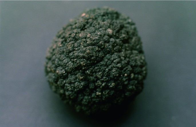
Credit Koelle (CC BY-SA 3.0, https://creativecommons.org/licenses/by-sa/3.0)
. Nodules grow incrementally at rates of 1-10 mm per million years. Image width approximately 20 cm.

The Cook Islands is taking the prospect of seabed mining very seriously and has developed a range of governance tools, legislation, and expertise to prepare for a future possible industry (McCormack 2016; Petterson and Tawake 2018). The richest deposits of polymetallic manganese nodules in the Cook Islands are mainly within the Penrhyn Basin region of the EEZ, on the Eastern side of the Manihiki Plateau. The Cook Islands Government is targeting this region for mining and beginning to plan how mines can operate within the basin in a way that (i) does not impact too much on the ocean floor and its biota; (ii) does not skew the economy of the Cook Islands too much; and (iii) provides a long-term sustainable source of funding for the Cook Islands, perhaps for a century or more.
This approach demonstrates the integrated approach needed for policymaking, integrating geoscience into broader socio-economic development discourses (e.g., Petterson 2019). Geoscience provides the data for the spatial extent and grade of the mineral deposit. It also provides data for the topographic and geological model of the ocean floor. Together with bioscience, geoscience assists with the understanding of ocean floor ecosystems. Oceanography provides data and an understanding of the ocean currents and biochemical variations within the water column. This informs our understanding of the origin of manganese nodules and how waste water is managed during the mining process, as well as in broader environmental assessment regarding the distribution of biota within the EEZ and the design of complementary marine parks (see Sect. 14.4.1). Geoscience and mining engineering knowledge are combined in developing a range of mining operational strategies recommended for minimising ocean floor disturbance, and management of ore and waste material transportation. Set-aside areas are being considered that are in adjacent sites, down-current of mining activities (McCormack 2016). These areas will be ‘no-mining zones’ and be used to compare and contrast ecosystems and environments with adjacent mined zones.
14.4.3 Renewable Energy Resources
As previously noted, many SIDS lack reliable, and sufficient power, with a dependence on oil or the use of diesel generators. Power provision often cannot rely on costly gridded electricity networks alone, but will most likely look towards local grids in numerous locations or networks that rely on no grids or limited village-level connections. Increasing use of renewable technologies, including new ocean energy technologies, could bring greatly improved, reliable and increased output to provide for future development. Examples of land-based renewable technologies include solar, hydropower, wind, biomass, and geothermal.
-
Solar energy technologies have dropped exponentially in price over the past 10–20 years and battery life now extends to over eight hours or so (e.g., Asian Development Bank 2013). Solar energy is therefore becoming an increasingly attractive option in remote Pacific island locations, as well as supplementing power supply in urban regions.
-
Hydropower will become increasingly important. Pacific countries such as Fiji, Papua New Guinea and Samoa all utilise hydropower to a significant extent already as part of their overall energy mix. For example, in Fiji hydropower already contributes 60% of the installed energy capacity.
-
Wind energy has hardly been realised in the Pacific, although a few countries have invested in small wind farms (e.g., Fiji and Vanuatu). The use of wind energy will undoubtedly grow with time as it has in Europe over the past decade, for example.
-
Biomass-generated power plants are another option, as tropical countries have rapid biomass growth rates. One biomass plant will shortly come on line in Fiji, developed by South Korea.
-
Geothermal energy is possible in some countries, with Fiji, Papua New Guinea, Samoa, Solomon Islands, Tonga, and Vanuatu having moderate to high geothermal potential, for example.
Both solar and wind can be deployed in oceans, requiring expertise in offshore geotechnical engineering. Other sources of energy derived from ocean activity include wave and tide energy, and ocean thermal energy conversion (OTEC). The latter uses cold deep seawater as a heat sink, and uses warm surface seawater as a heat source to produce electricity. In closed OTEC systems, a low-temperature boiling working fluid (refrigerant), such as difluoromethane (R32) or ammonia, is vaporised at low temperature by the heat of warm ocean surface water, and condensed by cold deep ocean water. In open OTEC systems, seawater itself is the working fluid. This creates a continuous flow of working fluid, which rotates a turbine and produces electricity (Fig. 14.11). OTEC plants can be based on land with pipes extending to around 1 km below sea level, or fully marine platforms.

Adapted with permission from KRISO
Principles of OTEC generation. Vapours from warm seawater are used as the operational working fluid in an open-OTEC situation to drive an electricity generating turbine, then cooled and condensed, using cold seawater. The system can also generate freshwater and waters of differing salinity/temperature/water depth for aquaculture and agriculture purposes
OTEC can generate surplus electricity when there is a temperature difference higher than 17 °C, between the surface and deeper waters. In the equatorial region, the temperature difference between ocean surface water and deep water (at about 1 km depth) is in the range of 20–25 °C throughout the year. Kiribati and Marshall Islands are examples of Pacific atoll countries with high ocean thermal conversion potential. Figure 14.12 shows that large areas of the ocean have the potential to generate electricity by OTEC, including Mexico, the Caribbean, the Philippines, Indonesia, Malaysia, coastal regions of east and west Africa, and small island states.

Adapted with permission from KRISO
Global map of temperature differences between surface waters and 1 km deep waters in the global ocean. KRISO plan to deploy a 1 MW land-based OTEC plant in Kiribati, in 2020.
OTEC boasts little to no seasonal variation throughout the day and seasons. For remote islands and coastal villages that have no power grids, OTEC can provide clean, self-reliant, sustainable energy. Deep seawater and surface seawater required for the operation of OTEC power can be used on land for multipurpose uses before returning to the sea (e.g., agriculture, refrigeration, and aquaculture). Deep seawater, still cold, can be used for cooling of surrounding buildings and houses, and, because it is clean, it can be used for seawater desalination, hydroponics, and aquaculture.
OTEC, as a concept, is not new, but the realisation of scaled-up plants that produce significant amounts of electricity has been slow. Most OTEC plants are land-based. Experiments and demonstrations on full, ocean-sited plants (i.e., a power station set within a full ocean environmental setting) have been limited and have met with little success to date. One current developmental full, ocean-sited plant is the NEMO project, supported by the EU with an aim of installing a 16 MW OTEC plant on the Atlantic island of Martinique. Korea Research Institute of Ships and Ocean Engineering (KRISO) plans to deploy a 1 MW land-based OTEC plant for one year in South Tarawa, Kiribati. If tests are successful, this may lead to longer term projects and fully ocean deployed projects (Fig. 14.13).

(© Hyeon-Ju Kim, Korea Research Institute of Ships and Ocean Engineering)
1 MW Ocean Thermal Energy Conversion plant field experiment in Korea waters
14.5 Science Capacity for Ocean Management
Increasing scientific knowledge, developing research capacity, and transferring marine technologies to improve ocean health and support development of SIDS and the least developed countries are central to SDG 14. This requires enhanced research and development capacity in all countries (see SDG 9), effective scientific institutions at national and regional levels (see SDG 16), and effective partnerships for development (see SDG 17). These themes are explored in depth in these respective chapters, and we refer the reader to them. Below we set out some examples that integrate geoscience and ocean management.
-
The Pacific Community (SPC)Footnote 1 is the principal scientific and technical agency supporting development in the Pacific, owned and governed by its 26 members. Its Geoscience Division aims to ‘apply geoscience and technology to realise new opportunities for improving the livelihoods of Pacific communities’. The Geoscience for Development Programme provides applied ocean, island and coastal geoscience services to member countries, providing expertise in oceanography, coastal processes and geomorphology, and hydrodynamic modelling (SPC 2019).
-
The Caribbean Community (CC or CARICOM)Footnote 2 has its headquarters in Georgetown, Guyana. This grouping of fifteen member states, and five associate members, supports and engages in geoscience and environmental activities from research to practice, and policy advice. The CARICOM/Caribbean Call to Action for SDG 14 included commitments to addressing the plastic pollution issue, establishing marine conservation areas, and developing a range of marine and coastal governance policies.
-
The Coordinating Committee for Geoscience Programmes in East and Southeast Asia (CCOP)Footnote 3 is based in Bangkok, Thailand. This intergovernmental organisation has 15 member countries from the East/SE Asia region. CCOP exists to promote the contribution of geoscience throughout the region and beyond for economic and social well-being, including links to SDG 14. CCOP develops conferences, and professional development and training activities aimed at sharing knowledge and expertise among its member countries.
-
The One Ocean Hub,Footnote 4 funded by UK Research and Innovation (UKRI) through the Global Challenges Research Fund (GCRF), aims to transform our response to the urgent challenges facing our ocean, developing an integrated approach to managing how they are used. The Hub specifically addresses the challenges and opportunities of South Africa, Namibia, Ghana, Fiji and Solomon Islands, and will share knowledge at regional (South Pacific, Africa, and Caribbean) and international levels. The Hub is led by the University of Strathclyde (UK), with more than 50 partners around the world, including those with geological expertise.
-
Significance of Modern and Ancient Submarine Slope LandSLIDEs (S4LIDE)Footnote 5 is an International Geoscience Programme (IGCP) project, supported by UNESCO and the International Union of Geological Sciences. S4LIDE brings together geoscientists from academia and industry to form an international and multidisciplinary platform to develop a more cohesive understanding of submarine landslides.
-
The Commonwealth Marine Economies ProgrammeFootnote 6 aims to support 17 Commonwealth SIDS to develop their marine (or ‘blue’) economies in a sustainable, resilient, and integrated way. The project is led by the UK Foreign and Commonwealth Office, with partners including the UK National Oceanography Centre, UK Hydrographic Office, and the UK Centre for Environment, Fisheries and Aquaculture Science. In Grenada, for example, this programme includes coastal vulnerability mapping, and an aim to integrate with regional and global natural hazard monitoring networks (FCO 2018).
-
The Joint Group of Experts on the Scientific Aspects of Marine Environmental Protection (GESAMP)Footnote 7 provides advice to the UN system, working under the auspices of 10 key UN agencies (e.g., the International Maritime Organisation, Food and Agriculture Organisation, World Meteorological Organisation, and UN Environment). The group has working groups on themes such as marine geoengineering, trends in coastal pollution, and impacts of mining waste.
-
The International Seabed Authority (ISA)Footnote 8 is a United Nations body established by the UN Convention on the Law of the Sea in 1994, and based in Kingston, Jamaica. The ISA has 167 members, and the European Union as a collective member. The ISA is responsible for the issuance of exploration and mining licences for seabed mineral-related activities within international waters, and the development of legal and regulatory systems for seabed mining.
These examples of institutions and initiatives demonstrate that geoscientists are connected to existing groups working to deliver the ambitions of SDG 14. The geological record provides a fundamental source of information on how our planet has previously responded to higher global temperatures, the melting of continental ice, and the acidification of oceans. Biogeochemists are pioneering approaches to understand the cycling of carbon (and other elements) through the natural environment (including interactions between the lithosphere, atmosphere, and hydrosphere). The development challenges of many SIDS have a strong connection to the geological environment—access to potable water, access to a reliable and sustainable energy supply, resilience to multi-hazard environments, and management of infrastructure and waste in confined spatial areas. While marine exclusive economic zones are demarcated by borders (as illustrated in Fig. 14.2), many of the challenges affecting our oceans are global and require collaborations across disciplines, sectors, and nations if we are to deliver appropriate solutions to address these.
14.6 Key Learning Concepts
-
SDG 14 focuses on the sustainable management and development of the oceans. Key focus areas include marine pollution, marine environment, impacts of environmental and climate change, ocean health, and sustainable development of resources such as fisheries, minerals, and energy. This chapter highlights the close, symbiotic links between oceans and ocean/coastal communities, and how geoscience can help to address and deliver the ambitions of SDG 14.
-
Small Island Developing States, or SIDS, exist in all the world’s oceans, particularly the Caribbean and western Pacific regions. SIDS are characterised by relatively small land areas, large to very large ocean areas, geographical isolation, an archipelago geography, and limited opportunities for economic development. They also support unique cultures and ways of life, with a particularly close connection between humans and the open ocean.
-
Oceans are the lowest basins on Earth and will receive much of the pollution produced by humans, as rivers and gravity tend to move material to the lowest point of gravitational potential energy (the oceans). Plastics are an excellent tracer for human pollution. Within the last 60 to 70 years, plastics have found their way into the deepest parts of the ocean and are a new anthropogenic ocean sediment. All oceans have plastic concentration zones at their surface. Plastics have serious health and mortality impacts on marine life. Human consciousness related to plastic pollution is growing rapidly, and many parts of the world are controlling/reducing plastic waste, perhaps for the first time in history.
-
Sea-level rise occurs due to water thermal expansion and the melting of ice. Current sea-level rise is a consequence of human-induced climate change, with low-lying atoll islands particularly susceptible to inundation. There are a range of scientific opinions about the future of low-lying atolls. Some scientists predict that they will respond to changing ocean conditions and survive into the 2100 s and beyond, with others indicating that atolls may be uninhabitable by 2030–2040. Policies must be developed to optimise responses to sea-level rise within atoll countries.
-
The absorption of carbon dioxide into the oceans results in acidification. This process dissolves calcium carbonate, the key constituent of marine mollusc shells, making it difficult for marine molluscs to bio-generate new shells, and adversely impacts reef ecosystems.
-
The holistic management of marine space in 3-dimensions will become an increasing part of implementing SDG 14, as ocean activities become ever more prominent. Geoscientists can help shape the design of marine conservation parks, advising on the geodiversity that a park should include.
-
Three types of seabed minerals occur on the ocean floor: seabed sulphides produced by hydrothermal vent mineralisation, and cobalt-rich crusts and manganese (or polymetallic) nodules, which grow slowly on the ocean floor or seamount summits. These mineral deposits contain a wide range of metals, including those needed for new ‘green’ technologies. Mining of seabed minerals may occur within the next decade, needing consideration of how environmental challenges will be managed and avoided.
-
The ocean also provides energy resources, with a lack of access to sustainable energy supplies being a particular challenge in SIDS. Solar and wind can be deployed in oceans, requiring expertise in offshore geotechnical engineering, and ocean activity can be converted to electricity using wave energy, tide energy, and ocean thermal energy conversion (OTEC). The latter uses cold deep seawater as a heat sink, and uses warm surface seawater as a heat source to produce electricity.
-
SDG 14 emphasises the need for increasing scientific knowledge, research capacity, and marine technology transfer. Many initiatives are helping to connect the expertise and skills of geoscientists with ocean management. These approaches often bring together partners from across countries and disciplines. The concept of interconnected geoscience links the application of geoscience to contextual developmental and environmental situations.
14.7 Educational Ideas
In this section, we provide examples of educational activities that connect geoscience, the material discussed in this chapter, and scenarios that may arise when applying geoscience (e.g., in policy , government, private sector international organisations, and NGOs). Consider using these as the basis for presentations, group discussions, essays, or to encourage further reading.
-
Examine bathymetric and oceanographic maps noting the sheer variety of the ocean floor seascapes (e.g., ocean ridges and mountains, seamounts and volcano chains, trenches, island arc systems, ocean islands, abyssal plains, and fracture zones), contributing to ecological diversity. Imagine you were designing a ‘marine geopark’ to profile geological diversity and its relationship with biodiversity. What features would you like this to include, and what impact may they have on the biodiversity that thrives in the region?
-
Study the scattered distribution of ocean islands and small island states in the Pacific, Indian, and Atlantic Oceans, and their archipelago nature. In small groups, select an example and prepare a five-minute talk on their history of settlement, geology, and economic and developmental links to the ocean. Have a class discussion on similarities and differences between the examples presented, the challenges in governing and administering such island nations, and how geoscientists are actively contributing to sustainable development in SIDS.
-
Study a global map of coral reefs, noting their distribution patterns and the rich biodiversity linked to reefs. Undertake a study identifying which reefs are affected and unaffected by the effects of climate change (e.g., ocean acidification). What actions are needed to reduce ocean acidification? Explore the options and prepare a one-page summary of recommendations for policymakers.
-
What overlap is there between the metals found in mobile phones and the metals found in seabed minerals? What challenges will seabed mining bring in environmental and technological terms?
-
What linkages exist between SDG 14 and other SDGs (i.e., how can delivering SDG 14 help to achieve other SDGs, how can progress in other SDGs help achieve SDG 14)? Map out these relationships and identify opportunities for geoscientists in diverse sectors to help deliver the ambitions of SDG 14. What other sectors and disciplines would geoscientists need to partner with to deliver solutions to the challenges facing oceans around the world?
Notes
- 1.
- 2.
- 3.
- 4.
- 5.
- 6.
- 7.
- 8.
Further Reading and Resources
Beiras R (2018) Marine pollution: sources, fate and effects of pollutants in coastal ecosystems. Elsevier, 408 p. https://doi.org/10.1016/C2017-0-00260-4
Church JA, Clark PU, Cazenave A, Gregory JM, Jevrejeva S, Levermann A, Merrifield MA, Milne GA, Nerem RS, Nunn PD, Payne AJ, Pfeffer WT, Stammer D, Unnikrishnan AS (2013) Sea level change. Stocker TF, Qin D, Plattner G-K, Tignor M, Allen SK, Boschung J, Nauels A, Xia Y, Bex V, Midgley PM (eds) In: Climate change 2013: the physical science basis. Contribution of working group I to the fifth assessment report of the intergovernmental panel on climate change. Cambridge University Press, Cambridge, UK and New York, NY, USA
Heidkamp CP, Morrissey J (eds) (2019) Towards coastal resilience and sustainability. Routledge, Oxon, 360 p
Miller KA, Thompson KF, Johnston P, Santillo D (2018) An overview of seabed mining including the current state of development, environmental impacts, and knowledge gaps. Front Mar Sci 4:418
Petterson MG (2019) Interconnected geoscience for international development. Episodes 42(3):225–233. https://doi.org/10.18814/epiiugs/2019/019018
Petterson MG, Tawake AK (2016) Toward inclusive development of the Pacific region using geoscience. In: Wessel GR, Greenberg JK (eds) Geoscience for the public good and global development: toward a sustainable future. Geological Society of America Special Paper 520, pp 459–478
United Nations (2019) Small Island developing states. Available at: https://sustainabledevelopment.un.org/topics/sids. Accessed 2 Aug 2019
Stewart RH (2008) Introduction to physical oceanography, 358 p. Available at: https://open.umn.edu/opentextbooks/textbooks/introduction-to-physical-oceanography. Accessed 1 Oct 2019
References
Asian Development Bank (2013) Vanuatu National Energy Road Map. Government of Vanuatu, 99pp
Becker M, Meyssignac B, Letetral C, Llovel W, Cazenave, Delcroix T (2012) Sea level variations at tropical Pacific Islands since 1950. Glob Planet Chang 80–81:85–98
Beiras R (2018) Marine pollution: sources, fate and effects of pollutants in coastal ecosystems. Elsevier
Biribo N, Woodroffe CD (2013) Sustain Sci 8:345. https://doi.org/10.1007/s11625-013-0210-z
BP (2019) BP statistical review of world energy, 68th edn. BP PLC, 1 St James Square, London, UK
Cummings V, Hewitt J, Rooyen AV, Currie K, Beard S, Thrush S, Norkko J, Barr N, Heath P, Halliday J, Sedcole R, Gomez A, McGraw C, Metcalf S (2011) Ocean acidification at high latitudes: potential effects on functioning of the Antarctic Bivale, Laternula elliptica. PLoS One 6(1):e16069. https://doi.org/10.1371/journal.pone.0016069. Published online 5 Jan 2011
Daigle K, Gramling C (2018) Why sea level rise varies from place to place. Available at: https://www.sciencenews.org/article/why-sea-level-rise-varies-place-place. Accessed 15 Oct 2019
Dickinson WR (2009) Pacific atoll living, how long already and until when? GSA Today 19:4–9
Doney SC, Mahowald N, Lima I, Feely RA, Mackenzie FT, Lamarque JF, Rasch PJ (2007) Impact of anthropogenic atmospheric nitrogen and sulfur deposition on ocean acidification and the inorganic carbon system. Proc Natl Acad Sci 104(37):14580–14585
Edwards JB (2013) The logistics of climate-induced resettlement: lessons from the Carteret Islands, Papua New Guinea. Refug Surv Q 32(3):52–78. https://doi.org/10.1093/rsq/hdt011
Edwards JB (2014) Phosphate mining and the relocation of the Banabans to northern Fiji in 1945: lessons for climate change-forced displacement. Le Journal de la Société des Océanistes 138–139. https://doi.org/10.4000/jso.7100
Eriksen M, Lebreton LC, Carson HS, Thiel M, Moore CJ, Borerro JC, Galgani F, Ryan PG, Reisser J (2014) Plastic pollution in the world’s oceans: more than 5 trillion plastic pieces weighing over 250,000 tons afloat at sea. PLoS ONE 9(12):e111913
Fabry VJ, Seibel BA, Feely RA, Orr JC (2008) Impacts of ocean acidification on marine fauna and ecosystem processes. ICES J Mar Sci 65(3):414–432
FAO (2018) The state of the world's fisheries and aquaculture. Available at: http://www.fao.org/state-of-fisheries-aquaculture/2018/en/. Accessed 15 Oct 2019
FCO (2018) Commonwealth Marine Economies Programme—Grenada Country Review. https://assets.publishing.service.gov.uk/government/uploads/system/uploads/attachment_data/file/769184/Commonwealth_Marine_Economies_Programme_-_Grenada_Country_review.pdf. Accessed 21 Aug 2019
Geyer R, Jambeck JR, Law KL (2017) Production, use and fate of all plastics ever made. Sci Adv 3:e1700782. https://doi.org/10.1126/sciadv.1700782
Government Office for Science (2018) Foresight - Future of the Sea. Available at: https://assets.publishing.service.gov.uk/government/uploads/system/uploads/attachment_data/file/706956/foresight-future-of-the-sea-report.pdf. Accessed 1 Oct 2019
Hagen K (2012) Resilience, response, recovery and ethnicity in post disaster processes. SPC SOPAC Technical report PR 182. Suva, Fiji
Hallam A (1992) Phanerozoic sea-level changes. Columbia University Press, USA
Halpern BS, Longo C, Hardy D, McLeod KL, Samhouri JF, Katona SK, Kleisner K, Lester SE, O’Leary J, Ranelletti M, Rosenberg AA, Scarborough C, Selig ER, Best BD, Brumbaugh DR, Chapin FS, Crowder LB, Daly KL, Doney SC, Elfes C, Fogarty MJ, Gaines SD, Jacobsen KI, Karrer LB, Leslie HM, Neeley E, Pauly D, Polasky S, Ris B, St Martin K, Stone GS, Sumaila UR, Zeller D (2012) An index to assess the health and benefits of the global ocean. Nature 488(7413):615
Hoegh-Guldberg O (2015) Reviving the Ocean Economy: the case for action—2015. WWF International, Gland, Switzerland, Geneva, 60pp
House of Lords (2019) The future of seaside towns. https://publications.parliament.uk/pa/ld201719/ldselect/ldseaside/320/320.pdf. Accessed 21 Aug 2019
ILO (2015) Cyclone PAM causes devastating impact on employment and livelihoods. https://www.ilo.org/suva/public-information/WCMS_368560/lang–en/index.htm. Accessed 15 Oct 2019
Irwin G (1998) The colonisation of the pacific plate: chronological, navigational and social issues. J Polyn Soc 107(2):111–144
Jambeck JR, Geyer R, Wilcox C, Siegler TR, Perryman M, Andrady A, Narayan R, Law KL (2015) Science 347(6223):768–771. https://doi.org/10.1126/science.1260352
Kench PS, McLean RF, Nichol SL (2005) New model of reef-island evolution: Maldives, Indian Ocean. Geology 33(2):145–148. https://doi.org/10.1130/g21066.1
Kench PS, McClean RF, Brander RW, Nichol SL, Smithers SG, Ford MR, Aslam M (2006) The Maldives before and after the Sumatran tsunami. Geology 34(3):177–180. https://doi.org/10.1130/g21907.1
Kench PS, Owen SD, Ford MR (2014) Evidence for Coral Island formation during rising sea level in the Central Pacific Ocean. Geophys Res Lett. https://doi.org/10.1002/2013gl059000
Kench PS, Thompson D, Ford MR, Ogawa H, McLean RF (2015) Coral islands defy sea-level rise over the past century: records from a central Pacific atoll. Geology 43(6):515–518. https://doi.org/10.1130/g36555.1
Kench PS, Ford MR, Owen SO (2018) Patterns of island change and persistence offer alternate adaptation pathways for atoll nations. Nat Commun 9:1–7. https://doi.org/10.1038/s41467-018-02954-1
Liu Y, MacFadyen A, Ji Z-G, Weisberg RH (2011) Monitoring and modelling the deepwater horizon oil spill: a record-breaking enterprise. Washington DC American Geophysical Union Geophysical Monograph Series. Geophysical Monograph Series, vol 195. https://doi.org/10.1029/gm195
McCormack G (2016) Cook Islands seabed minerals. A precautionary approach to mining. Rarotonga, Cook Islands: Cook Islands Natural Heritage Trust, 33pp. ISBN 978-982-98133-1-2
McLean R, Kench P (2016) Destruction or persistence of coral atoll islands in the face of 20th and 21st century sea-level rise? Wiley Interdiscip Rev-Clim Chang 6(5):445–463. https://doi.org/10.1002/wcc.350
Minderhoud PSJ, Erkens G, Pham VH, Bui VT, Erban L, Kooi H, Stouthamer E (2017) Impacts of 25 years of groundwater extraction on subsidence in the Mekong delta, Vietnam. Environ Res Lett 12(6)
NOAA (2019a) What is Ocean Acidification? https://www.pmel.noaa.gov/co2/story/What+is+Ocean+Acidification%3F. Accessed 20 Aug 2019
NOAA (2019b) How does oil impact marine life? https://oceanservice.noaa.gov/facts/oilimpacts.html. Accessed 10 Oct 2019
Petterson MG, Tawake AK (2018) The cook islands (South Pacific) experience in governance of seabed manganese nodule mining. Ocean Coast Manag 167:271–287. https://doi.org/10.1016/j.ocecoaman.2018.09.010
Roser M (2019) Oil Spills. https://ourworldindata.org/oil-spills'. Accessed 15 Oct 2019
Ritchie, H. and Roser, M. (2018) Plastic pollution. https://ourworldindata.org/plastic-pollution. Accessed 15 Oct 2019
Sabine CL, Feely RA, Gruber N, Key RM, Lee K, Bullister JL, Wanninkhof R, Wong CSL, Wallace DW, Tilbrook B, Millero FJ (2004) The oceanic sink for anthropogenic CO2. Science 305(5682):367–371
Sosdian SM, Greenop R, Hain MP, Foster GL, Pearson PN, Lear CH (2018) Constraining the evolution of Neogene ocean carbonate chemistry using the boron isotope pH proxy. Earth Planet Sci Lett 498:362–376
SPC (2014) Assessing vulnerability and adaptation to sea-level rise: Lifuka Island Ha’apai, Tonga. Pacific Community Geoscience Division
SPC (2019) Pacific community geoscience division. https://gsd.spc.int/index.php. Accessed 21 Aug 2019
Storlazzi CD, Elias EPL, Berkowitz P (2015) Many atolls will become uninhabitable within decades due to climate change. Sci Rep 5:14546. https://doi.org/10.1038/srep14546
Storlazzi CD, Gingerich SB, van Dongeren A, Cheriton OM, Swarzenski PW, Quataert E, Voss CI, Field DW, Annamalai H, Piniak GA, McCall R (2018) Most atolls will be uninhabitable by the mid-21st century because of sea-level rise exacerbating wave-driven flooding. Sci Adv 4(4):p.eaap9741
United Nations (2012). Sustainable supply chains. The dhaka principles for migration with dignity. http://supply-chain.unglobalcompact.org/site/article/141
United Nations (2015) The millennium development goals report. www.un.org/millenniumgoals/2015_MDG_Report/pdf/MDG%202015%20rev%20(July%201).pdf. Accessed 13 Aug 2019
United Nations (2016) Progress towards the sustainable development goals: report of the secretary-general. UN Economic and Social Council. E/2016/75
United Nations (2019) SDG 14—life below water. https://www.un.org/sustainabledevelopment/oceans/. Accessed 21 Aug 2019
USGS (1995) Sea level change: lessons from the geologic record. U.S. Geological Survey, U.S. Department of the Interior. FS-117–95
Wahl T (2017) Sea-level rise and storm surges, relationship status: complicated. Environ Res Lett 12(11):111001
Waters CN, Zalasiewicz J, Summerhayes C, Barnosky AD, Poirier C, Gałuszka A, Cearreta A, Edgeworth M, Ellis EC, Ellis M, Jeandel C (2016) The anthropocene is functionally and stratigraphically distinct from the Holocene. Science 351(6269):aad2622
Webb AP, Kench PS (2010) The dynamic response of reef islands to sea-level rise: Evidence from multi-decadal analysis of island change in the Central Pacific. Glob Planet Chang 72(3), 234–246. https://doi.org/10.1016/j.gloplacha.20https://doi.org/10.05.003
Wilcox C, Sebille EV, Hardesty BD (2015) Threat of plastic pollution to seabirds is global, pervasive, and increasing. Proc Natl Acad Sci 112(38):11899–11904. https://doi.org/10.1073/pnas.150218112
Woodall LC, Sachez-Vidal A, Canals M, Paterson GL, Coppock VS, Calafat A, Rogers AD, Narayanaswamy BE, Thomson RC (2017) The deep sea is a major sink for microplastic debris. R Soc Open Sci 1:140317. https://doi.org/10.1098/rsos.140317
World Bank (2019a) Mortality rate attributed to unsafe water, unsafe sanitation and lack of hygiene (per 100,000 population). https://data.worldbank.org/indicator/SH.STA.WASH.P5. Accessed 1 Oct 2019
World Bank (2019b) Prevalence of undernourishment (% of population). https://data.worldbank.org/indicator/sn.itk.defc.zs. Accessed 1 Oct 2019
Author information
Authors and Affiliations
Corresponding author
Editor information
Editors and Affiliations
Rights and permissions
Copyright information
© 2021 Springer Nature Switzerland AG
About this chapter

Cite this chapter
Petterson, M.G., Kim, HJ., Gill, J.C. (2021). Conserve and Sustainably Use the Oceans, Seas, and Marine Resources. In: Gill, J.C., Smith, M. (eds) Geosciences and the Sustainable Development Goals. Sustainable Development Goals Series. Springer, Cham. https://doi.org/10.1007/978-3-030-38815-7_14
Download citation
DOI: https://doi.org/10.1007/978-3-030-38815-7_14
Published:
Publisher Name: Springer, Cham
Print ISBN: 978-3-030-38814-0
Online ISBN: 978-3-030-38815-7
eBook Packages: Earth and Environmental ScienceEarth and Environmental Science (R0)