
Abstract
The current Egyptian situation is framed by land and water scarcity, which are under severe pressure. The Nile Delta is one of the most densely populated deltas in the world. Soil and water resources are at the center of sustainable development and are critical for socio-economic development.
Nile Delta branches gain water from the aquifer in some reaches and lose water to the aquifer in other reaches. The flow directions between groundwater and surface water can change seasonally with variations of the water table level with respect to the level in nearby waterways. Available data on the evolution of the salinity of groundwater in the Delta indicate that the construction of the High Aswan dam resulted in a shift of salinity isolines towards the seashore, and that current pumping rates have not yet critically affected this balance. Possible localized over-pumping, however, results in “up-coning” of salinity from deeper layers. Contamination of groundwater by agriculture and more prominently by seepage from domestic and industrial effluents had already attained worrying levels. This may jeopardize the quality of the Nile Delta aquifer in the end. The increasing use of groundwater for irrigation poses a serious threat to food security and could lead to unaffordable prices of staple foods. Therefore, groundwater overuse rising could hit food prices. Aquifer depletion can induce significant environmental degradation, such as land subsidence and seawater intrusion. The amount of non-renewable groundwater used for irrigation was doubled in Nile Valley and Delta. The annual groundwater abstraction in the Nile aquifer system and fringes is about 4.6 billion m3. Another 0.5 billion m3 is abstracted from the desert aquifers and the coastal areas. Groundwater abstraction is expected to increase to 11.4 billion m3. Model output revealed that groundwater recharge has not changed significantly over time, while pumping has. Because of these trends, groundwater was estimated to be in a deficit of approximately 24 billion m3 (±15%) in year 2011, compared to year 1957.
Most of the Nile Delta soils are recent alluvial soils. The soils generally have a light to heavy clay texture. The clay content varies from 40% in the south to nearly 70% in the north. The soils located near the north coast and lakes are of marine and alluvial deposits. Close to the desert fringe on both sides of the Delta occurs the desert sandy plains, which are flat to undulating topography. The soils of the coastal plains and beaches are sandy with some low to medium longitudinal sand dunes. The salinity problem becomes more severe in the Delta as we approach the seacoast and lakes, due to the effect of the shallow, saline groundwater and the brackish water intrusion from the sea and lake. The old and young terraces of both western and eastern sides of the Nile Delta are of alluvial origin and non-uniform in nature. Most of the soils are originated from the ancient Nile sediments, which are mostly derived from igneous and metamorphic rocks of the Abyssinian Plateau. The soils are alluvial deposits of the Nile Delta (Qatabeya) and valley (Qena), swamps and fluviomarine-lacustrine deposits (El-Manzala), beach sands (Edku). The old alluvial soil is more developed than other soils.
Access provided by Autonomous University of Puebla. Download chapter PDF
Keywords
1 Introduction
Climate change is likely to increase the stress on resources, especially soil and water, which are the most imperative and central factors in agriculture development. The current Egyptian situation is framed by land and water scarcity, which is under severe pressure from increasing populations, fast development, agriculture intensification, and the degrading environment in Egypt. The contested agricultural land makes up only 4% of the country. About 95% of the people (93 million in 2016 [1]) actually live on the scarce agricultural land in the Nile Valley and Delta in a country that is otherwise a desert. With a population density of 1,500 inhabitants per square kilometer when including the capital [2], the Nile Delta is one of the most densely populated delta in the world. On the one hand, soil and water resources are at the center of sustainable and socio-economic development. On the other hand, water and soil resources are under threat because of the way we treat it. High Dam has freed the Egyptian Nile Valley and Delta from floods, but also dramatically confines sediment transport and water availability. Since the 1960s, the Egyptian Nile is completely controlled by the High Dam and a series of barrages along its course to the Mediterranean Sea. A Grand Ethiopian Renaissance Dam (GERD) will put additional pressure on the territory [3]. As our soil and water resources come under increasing pressure, hard decisions should be made so that resources are not degraded or tipping points reached.
Water is an irreplaceable resource and it is only renewable if well managed. As the demand on freshwater increases, consideration regarding non-conventional water resources consequently increases in Egypt. The demand for adequate and safe supplies of water is becoming crucial especially in the overpopulated of Egypt. Water resources in Egypt are the Nile, rainfall, deep groundwater, and desalinated water complimented by shallow groundwater in the Nile Delta and both re-used agricultural drainage and treated wastewater as non-conventional water resources [4]. Eighty-six percent of that water comes from the Nile and around 11% from underground sources, 2% is recycled [5]. Groundwater plays a vital role in water supply everywhere throughout Egypt. In the desert regions, groundwater is considered as one of the key sources for both rural and agriculture water supplies. Although several aquifer systems exist in Egypt, the most important is the Nile aquifer system, which covers the Nile floodplain and the desert fringes where 90% of Egypt’s population lives [6]. In the center of the floodplain, the aquifer is semi-confined (10 m of silt-clay). However, on the edges of the floodplain and the desert fringes, the aquifer becomes phreatic. The thickness of the aquifer ranges from 300 m in the south to 800 m in the Delta [6]. Groundwater in the Nile aquifer and desert fringes is not a resource in itself as it is replenished from the river Nile by seepage from canals and percolation from irrigation application and infiltration. The flow direction is, with a few local exceptions, south north. Recharge varies according to hydrogeological conditions. Extraction from the aquifer is by seepage to the river and extraction from wells. Increasing abstraction to meet rising demand has raised concerns about the sustainability of the groundwater resource. The annual groundwater abstraction in the Nile aquifer system and fringes is about 4.6 billion m3 [7]. Another 0.5 billion m3 is abstracted from the desert aquifers and the coastal areas. Groundwater abstraction is expected to increase to 11.4 billion m3 [8], thus these are posing a challenging question to researchers: Are the land and groundwater resources in the Nile Valley and Delta sustainable? Accordingly, the main scope of the present chapter is to assess the land and groundwater resources and its sustainable development in the Nile Valley and Delta of Egypt and its fringes.
2 Description of the Nile Valley and Delta
2.1 Egypt Gift of the Nile and Egyptians
The Nile in Egypt was drilled as a result of unusual circumstances caused the Mediterranean basin drying since about 6 million years ago, due to higher Gibraltar (which linking the Mediterranean with the Atlantic Ocean), and thus the arrival of water to the Mediterranean sea was stopped. It transforms into a lake, which its water was evaporated until dried [9]. It was connected as a result of earth movements and volcanic eruptions associated with the formation of the great African Rift Valley, which led to the formation of lakes Tana and Victoria. In addition, the grace of God and a gift from God to Egypt caused these ground movements in turning the water from the Ethiopian highlands to the Nile instead of from the Red Sea as it was in the past. With this shift in the earth movements, which have formed the Rift Valley, the Nile River was connected to Africa and the water has been arrived from the sources. Otherwise, the Nile River has dried up and become like other desert valleys such as the Wadi Qena and Assiouti and the Egyptian man was not able to settle down in the valley and not to establish a stable agricultural civilization [10].
Herodotus has said, “Egypt is the Gift of the Nile.” While others believe (and I am one of them) that “Egypt is the Gift of the Nile and Egyptians together.” The river passes through several countries starting from the upstream and downstream. There was no giant civilization influenced in human like ancient civilization. Nile water cannot make a civilization, but it is the Egyptian man, who controls runoff of the Nile and digging canals and drains. It has monitored the Egyptian priests’ stars to calculate the flood, and thus created astronomy. Is there found the people other than the Egyptian have a calendar for 4,000 years BC?
2.2 Nile History
The Neonile was arrived to Egypt in the declining snow era of the last ice and thus increased rainfall on the plateau of tropical lakes and the Ethiopian plateau especially between 12,500 and 10,000 years ago. It has led to an increase in the water, which the Nile carries them to Egypt, and began to form its fertile soil in the valley and delta. It became in its modern form after a series of changes over the Nile before reaching its current form, and can be summarized as follows [9]:
-
1.
The Eonile (5.4–6.0 million years ago) is being stuffy Nile because of drought Mediterranean Sea. The first Nile River was created because of the existence of a great fold (6 million years ago). The Mediterranean Sea dried up and turned into a desolate desert 6 million years ago because of the closure of the Straits of Gibraltar. It was then filled with water after a million years of drought (since 5 million years). These changes have had a significant impact on the pre-Nile. It was not connected to tropical Africa until only 800 thousand years ago.
-
2.
Gulf Sea Development (3.3–5.4 million years ago).
-
3.
The Paleonile or old Nile (1.8–3.3 million years ago) is a local river occupies the Gulf and followed by the desert developed (0.8–1.8 million years old) turned Egypt into the desert, the Nile stop the flow.
-
4.
The Prenile (400,000–800,000 years) is the first Nile in Egypt liaise tropical Africa.
-
5.
The Neonile (400,000 years till now) is a period dominated by a river less able and Communication Africa has become transient. Lake Victoria has been without any connection to the Nile for a long time after its inception and has been connected to the Nile River only 12,500 years after the height of its level by 26 m. Then the modern Nile was appeared in the Paleolithic and then another river in the Middle Stone Age and finally the back of the last Nile, which is currently called the Neonile. It was followed by the present Nile with a sustainable flow (12,000 years ago). The current Nile is a modern river born with rains that followed the decline of the last Ice Age snow (10,000 years ago). The ice age declined and the water level of the river increased and began to sink the silt that has been known for 7,500 years.
The River Nile has two sources of water: plateau tropical lakes and Ethiopian highlands with summer rains. Plateau lakes have five large lakes connected to the Nile. Some of these lakes are great rift (groove) lakes in the center of the west (Edward, George, and Albert), and others are large shallow (downward) lakes such as Victoria and Kyoga [11]. Lake Victoria (Fig. 1) is the largest lake with an area of about 69,000 km2 (more than double the Delta area and the valley of the River Nile). Lakes Victoria, Kyoga, and Albert have its present form because of earth movements that made up the Great African Rift. This is one of the most prominent geographical phenomena on the Earth’s surface, where a length of nearly 3,000 km, and its depth varies from place to place [9]. The rivers of the core of the Nile, which originates from the Ethiopian highlands, include the Blue, Atbara, and Sobat (Fig. 1), which stems from the volcanic area. Igneous rocks (basalt) are covered in the Ethiopian highlands, which cover the bulk of the plateau. The average rainfall is between 1,000 and 1,400 mm a year. The Ethiopian highlands are the source of most of the Nile water. However, the other water sources, even though it low, it makes the river flow sustained throughout the year. The lack of water arriving from tropical plateau was due to the loss of river water in the marshes and the various bodies in the region, where the biggest losses of the water were to the sea. Nile River enters the Egyptian territory near Adindan on the Egyptian–Sudanese border and holds the river for a distance of about 1,536 km until emptying into the Mediterranean Sea. The total length of the river from Aswan to Ras Delta at Cairo is about 981 km.

Nile River Basin
2.3 The Nile Delta and Valley Land
The land of Egypt was (before the arrive Nile) covered by the sea from the north since tens of millions of years (about 60 million years ago). It covered a large part of the north of Sudan. The sea began to retreat until its beach became the line running between El-Faiyum and Siwa, and thereafter seaside has become close to the current position. Egypt with its lands extending over 1 million km2 is endowed with varied agro-ecological zones, which represents the greater majority of cultivated lands of the Nile Valley, as well as, most of the reclaimed desert lands, mainly, on the western and eastern fringes of the Delta in addition to relatively limited areas at on fringes of the Valley in Upper Egypt (total areas over 7.5 million feddans). The Nile Valley system extends from the Mediterranean shores of the Nile Delta to the north till Aswan in the south over an area extending from 22° to 32° latitude north under arid and hyperarid conditions.
Egypt has started many national plans to increase its cultivated areas to resettle the population outside the narrow valley and to build new communities to diminish hostility of its vast deserts. These potential areas included Nile Delta margins, the Western Desert, and North Sinai. Nile Delta reclamation projects included El-Tahrir (west of the Delta) to reclaim 0.2 million feddan, Maryout (near Alexandria) to reclaim 0.1 million feddan, and Nubariah (south of Alexandria) to reclaim 0.2 million feddan [12]. To the east of the Nile Delta, large reclamation projects were represented by the El-Salam (peace) Canal project, which aimed to reclaim about 0.6 million feddan in the Eastern Delta and Sinai regions by mixing drainage water from the Delta agricultural drains with the Nile water in a 1:1 ratio [13]. Further to the south, a mega reclamation project; the South Valley Development (known as Toshka project) was implemented to convey water from Lake Nasser behind the High Dam at southern Egypt to cultivate 0.5 million feddan by 2017 and resettle 7 million people in the Western Desert [14].
Soils varied including the fertile deep alluvial soils of the old Nile Valley, soils of the river terraces at different reliefs which are deep soils with gravelly and reddish subsoils, in addition to the soils of the fringes including desert calcareous soils of varied textures and non-calcareous soils characterized with low soil fertility and inferior soil physical, chemical, and biological properties.
2.4 The Nile Delta History
Herodotus since about 500 BC was the first one to name the Delta, because of the Latin Delta (▼) character [15]. The Nile basin by nearly 10,000 years has several branches (nine branches) and then reduced to seven branches, then five, then three, and finally the existing branches of Damietta and Rosetta. Toussoun [16] collects and achieves much information about the branches of the Nile. Maps and ancient manuscripts show that the seven branches were formed during the period leading up to the big increase happen in the sea level (5,000 years BC), in which the surface of the sea was low. These branches have been silting in times where the river was acting a little bit, and therefore the rate of deposition of silt over these branches. As for the failure silting of Damietta and Rosetta branches that it may be due to the branches that were ending directly into the sea are destined to inflation and survival, but the one which was aimed at the lakes are those which have as much atrophy and silting [17]. Figure 2 shows the old branches of the Nile, which were drawn by geographers and historians ancients. The following is a brief on these branches: (Fig. 2)
-
1.
Pelusiac branch was the main branch, relative to the town of Bellows (Farma).
-
2.
Tanitic branch was the secondary branch and takes named relative to Sais (Sun Sea). The Tanitic branch deposited material underneath what is now Manzala Lagoon, and prograded across to present day Port Said.
-
3.
Mendesian branch was the secondary branch, which was taken from the branch of Alsabenity its course and the original part of the small sea. The Mendesian branch formed a depositional center under the western portion of Manzala Lagoon and prograded (advance towards the sea) to the northeast to merge with the depositional center of the Tanitic branch. The supply of sediments by these two branches (Mendesian and Tanitic) gave rise to up to 40 m thick sections of Holocene deposits, currently underlying Manzala Lagoon. Around 1,500–2,500 years ago. These two branches silted up allowing the Damietta branch to become the largest contributor of Nile sediment flux [18].
-
4.
Phatnitic branch was the secondary branch of Sebennytic, which was taking its course in line with the lower part of the Damietta branch.
-
5.
Sebennytic branch was the main branch in the center of the Delta and starts at the top Delta and ends at Borollos tower and its name relative to Spenatios (Samanoud).
-
6.
Bolbitine branch was the secondary branch, which was subdivided from canopic near Damanhur being in the lower part of the Rosetta branch.
-
7.
Canopic branch was the third main western branch and was ended at Canopus (Abu Qir).
Fig. 2 
Old branches and historic cities of the Delta [9]

2.5 Current Nile Delta Description
Nile Delta starts in branching north of the City of Cairo (Fig. 3). The river is divided into Rashid (239 km) and Damietta (245 km) branches. The average width of the Rosetta branch 500 m, while the Damietta branch of about 270 m. Damietta branch and its drained water much lower than the discharge of the Rosetta branch, which discharges water up to one and half the Damietta branch. Rosetta is erosional branch, while the Damietta is depositional branch [19]. Environmental conditions have helped on the speed of the Nile Delta composition. These factors are leveling the surface of the deposition area, clay aggregates, which facilitates deposition by salts in seawater, and finally the lack influenced the Mediterranean Sea coast marine currents because it is one of the semi-enclosed seas. The length of the Delta from the south to the north (about 170 km), while the base up to about 220 km, an area of about 22,000 km2 (Fig. 3), twice the area of the valley.

The Nile Delta and its governments and coastal lakes
Average rainfall changes from 25 mm/year in the south and central part of the Delta to 200 mm/year in the northwestern part [20]. Excess rainfall is largely intercepted by the drainage system and cannot reach the aquifer [21]. The Nile Delta is among the most populated agricultural areas in the world, with 1,080–1,500 inhabitants per km2 [2, 22], covering nine governments with about 43% of the Egyptian population (about 39 million inhabitants) [1]. The “old” cultivated lands are in the Delta and “new” commonly reclaimed desert in the east and the west of the Delta. Coastal lagoons and lakes (Manzala, Borollus, Edku, and Mariout), salt marshes, and sabkhas are comprised the northern part of the Nile Delta. They are usually a low surface of depression composed by the removal of dry and loose material down to the groundwater level or the capillary water zone [23].
3 Groundwater Resources in the Nile Delta
Of six groundwater aquifers in Egypt (Fig. 4), the Nile aquifer is viewed as a fundamental source of groundwater abstraction as it represents 87% of the total groundwater abstraction in the country [25]. The Nile Delta aquifer is one of the biggest aquifers in Egypt with a total capacity of 500 Bm3 [26], around 15 times the amounts of water that enters the Delta every year through the river flow itself. The recharge source of the Nile Delta aquifer is the Nile water leakage from canals, drains, and the irrigated plots themselves [27]. The conjunctive utilization of groundwater and surface water plays an essential role during the period of peak irrigation demand. The amount of water abstraction from the Nile aquifer (Delta and Valley) was estimated in 2010 at 6.2 Bm3, which is under the safe yield (8.4 Bm3) estimated by MWRI [28].

Groundwater aquifers in Egypt [24]
The Nile Delta aquifer serves nine governments, and according to FAO [29] the total irrigated area by groundwater in the Nile Delta would amount to 414, 240 feddan. Little or no land areas are being irrigated with groundwater in Damietta, Port Said, and Kafr El Sheikh Provinces due to the effect of saline water intrusion from the Mediterranean Sea into those provinces, and that the higher share of the groundwater use occurs in El-Beheira governorate. This is due to the inclusion of western new lands (outside the Delta) in the statistics.
3.1 The Nile Delta Aquifer Depth
The elements of the Nile Delta aquifer have been perceived by various studies (e.g., [30,31,32]). The Nile Delta aquifer is viewed as a semi-confined aquifer shaped by Quaternary deposits. Figure 5 demonstrates the contour map of the depth underneath sea level of the lower boundary of the main Delta aquifer. The highest point of the aquifer is secured by a thin clay layer, which contrasts in thickness and disappears in some places (Fig. 5). In such places, the aquifer is thought to be phreatic since its free water surface is exposed to atmospheric pressure. The thin clay layer changes from 5 m in the south to 20 m in the center and achieves 50 m in the north of the Nile Delta (Fig. 5). The thickness and lithological contrasts of the clay layer have a great effect on the degree of hydraulic connection among ground and surface water [34]. The saturated thickness of the aquifer changes from 200 m in the southern parts to around 1,000 m in the northern parts [20].

Vertical cross section (a) at the center of Nile Delta [33]. Contour map (b) of the depth below sea level of the lower boundary of the main Delta aquifer
The depth of the groundwater table in the Nile Delta goes between 1 and 2 m in the north, 3–4 m in the center, and 5 m in the south [35]. Abd El-Fattah [36] studied the southern part of the central area of the Nile Delta and reasoned that the depth of water declines towards Rosetta branch (2.5–5 m). Thus, the flow of groundwater movement is from southeast to northwest towards Rosetta branch in the central part of the Nile Delta. Morsy [21] drew a regional contour map of groundwater depth and the piezometeric contour map in the Nile Delta region in 2008 in light of field observations. Areas with very shallow groundwater incorporate the region between Damanhur and Lake Edku and the saline depressions south of Lake Manzala, and near Ismailia. The ground elevation ranges between about 18 m above mean sea level (AMSL) in the south at Qanater El-Khairia to about 5 m (AMSL) near Tanta sloping down very gently in a northward direction by an average value of 1 m/10 km [34]. Besides, the Nile Delta slopes from east to west making the Damietta branch 2 m higher than the Rosetta branch [37]. According to Attia [38] and Farid [39], the Rosetta branch is as a discharge stream for groundwater at Kafr El-Ziyat and Tamalay cities, while it recharges the aquifer in the Edfina and Desouq region. The Damietta branch gathers water from the aquifer as the groundwater level of the aquifer is higher than the surface water level in the Rosetta branch [29].
Natural discharge of groundwater by evaporation and/or evapotranspiration occurs in the low lying areas with shallow groundwater tables as well as small depressions in the eastern Nile Delta, where water can be taken up by plants or moves upwards through capillary rise. Mabrouk [35] indicated that the total evapotranspiration rate of the Nile Delta using both the irrigation inflow and the aquifer storage is about 2,000 mm/year. Outflow of the Nile Delta aquifer also occurs towards the Moghra aquifer, along the fringes of the western Nile Delta. The total amount of groundwater flowing from the Nile Delta aquifer into the Moghra aquifer was estimated between 50 and 100 Mm3/year [40]. However, Morsy [21] observed that the drawdown of the groundwater levels in the Moghra aquifer was between 5 and 15 m due to the extensive groundwater exploitation.
An estimation of the amount of groundwater used in irrigation by Abu-Zeid [41] was about 906 Mm3/year in the Nile Delta area (326 Mm3/year in the East Delta, 73 Mm3/year in the Middle Delta, and 506 Mm3/year in the West Delta). The total annual groundwater abstraction for irrigation and drinking in the Nile Delta area was estimated by Morsy [21] to be 4.9 Bm3 in 2008. She indicated that the beginning of the increase in abstraction rates was 3 Bm3 in 1992 [40], which was due to the uncontrolled land cultivation in the reclaimed lands of the western Nile Delta. Mabrouk et al. [35] indicated that annual abstraction increased linearly by about 0.1 Bm3 per year, except from the period of 2003 till 2010, when abstraction increased by 0.2 Bm3 per year.
Fattah and Ragab [42] assess the depth to groundwater in the southern part of Nile Delta, Egypt (Fig. 6). Depth to groundwater decreases towards Rosetta branch and decreases close main irrigation canals and El-Rayahat. It ranges between 2.0 m at the northwest and 10 m at the southeast. Potentiometric heads decrease from the southeastern part to the north and northwestern parts. They range from 17 m above MSL at the eastern part to 6 m above MSL close to northwestern part around Rosetta branch. Groundwater shows low depths (<2.5 m) in areas close to the Rosetta branch, which indicates high vulnerability to pollution in this area. Areas of high groundwater depth (> 4 m) indicate moderately vulnerable to pollution. The general direction of groundwater movement is from southeast to northwest towards Rosetta branch which acts as a main drain for drainage water of most drains along its course and that leads to high vulnerability to pollution in the areas adjacent to the branch.

Depth to groundwater in Pleistocene aquifer of the southern part of the Nile Delta, Egypt
3.2 Management of the Nile Delta Aquifer
Many researchers have studied the Nile Delta aquifer, using several numerical models to simulate groundwater flows and to define and analyze the hydrological and topographic characteristics of the aquifer. A change in the groundwater level and salinity has been indicated by several researchers due to the rapid development of the land reclamation in the Western Nile Delta region. A whole set of studies testing several development scenarios has been undertaken by different researchers (e.g., [24, 43,44,45,46]). Different combinations of simulations and optimization models have been used to recommend a plan for the conjunctive use to optimize the benefits of using both ground and surface water [47, 48]. RIGW/IWACO [40] evaluates the potential of groundwater in the Western Nile Delta’s New Lands. They proposed increasing groundwater abstraction from 0.5 to 2.5 Bm3 for the period from 1990 to 2000 [21]. Mohammed [43] used satellite images to assess the increase in the area under cultivation from 1987 to 1998, and the area developed with groundwater in the Western Nile Delta between 1990 and 2000. They found an increase in the cultivated area exceeding that of the development plan of 1990, predicting that critical areas will face severe groundwater drawdown.
Khater et al. [44] studied the groundwater levels in Sadat City (one of the urban areas in the Western Nile Delta region), which depends on groundwater as the main source for irrigation. They indicated that continuous groundwater extraction exceeded the planned level, causing some hazards on the groundwater potentiality. Dawoud et al. [49] test two alternative management scenarios using GIS-based model for preserving the aquifer system in the Western Nile Delta. They proposed reducing the surface water inflow while increasing the annual abstraction of groundwater by about 450 Mm3. Alternatively, they recommended constructing a canal to increase the annual aquifer storage potential by about 23%. Likewise, Moll et al. [50] studied different management scenarios for the western Nile Delta aquifer to satisfy the need for 460,000 feddan of the new land reclamation. These scenarios studied alternative conjunctive uses for available water resources in the Western Nile Delta (surface water, groundwater, and drainage water reuse) to prevent aquifer depletion. They also recommended constructing a canal with 2.1 Bm3 of surface water and the increase of groundwater abstraction must not exceed 1.0 Bm3/year to avoid aquifer exploitation. Mohamed and Hua [51] developed a model to simulate the water resources in the Western Nile Delta. Unsustainable use of groundwater was indicated as the total amount of groundwater abstraction for irrigation (1.9 Bm3), which was larger than groundwater recharge (1.54 Bm3). They commented that this situation in the long term will undermine the capacity and sustainability of the aquifer and will lead to saltwater intrusion into this aquifer. They recommended reducing groundwater abstraction by 20% in order to reach a sustainable situation.
Switzman et al. [52] present an approach for generating transient groundwater model inputs (Fig. 7) to assess the groundwater resources in a highly data-sparse context of Wadi El Natrun. An ensemble of groundwater model inputs was generated and used in a 3D groundwater flow (MODFLOW) of Wadi El Natrun’s multi-layer aquifer system to analyze trends in water levels and water budgets over time. Model output revealed that groundwater recharge has not changed significantly over time, while pumping has. Because of these trends, groundwater was estimated to be in a deficit of approximately 24 billion m3 (±15%) in 2011, compared to 1957. In the 1990s, a significant trend in water level declines has been observed in monitoring records, which are directly attributed to abstraction. Over abstraction of groundwater is directly linked to declines in water levels and depletion of storage from all aquifers in the area. The problem is most severe in the Pleistocene and Pliocene aquifers due to their more limited storage capacity and longer history of being exploited.

Datasets records used to map the bottom elevation of each aquifer layer implemented in MODFLOW [52]
Morsy [21] studied the impact of groundwater development plan from the year 1992 to 2008 on the water table and highlighted waterlogging problems in both western and eastern fringes of the Nile Delta. She noted a drawdown of groundwater levels in the southern part of the western fringes of the Nile Delta (5–15 m) due to extensive exploitation of groundwater and lack of recharge. El-Fakharany [46] tested three strategies for reducing irrigation water supply from canals to El-Saidiya area (East Nile Delta) and substituting the reduction with groundwater. She examined the effect of different pumping rates in the long term, seasonal, and inter-annual strategies and recommended to satisfy 25% of the study area irrigation requirements with groundwater. In addition, Samak [53] simulated the groundwater flow at Abu-Kabir district in El-Sharqia governorate (East Nile Delta) using a numerical model (MODFLOW) to show the effect of the utilization of both groundwater and surface water to overcome irrigation water shortages. Ten scenarios of groundwater management were evaluated to determine the optimal conjunctive ground and surface water and the impact of continuous extraction of groundwater. The best and safest scenario recommended for water management in the studied area was able to satisfy 30% of agricultural demand from groundwater for a period of 20 years.
3.3 Groundwater Quality of the Nile Delta
Groundwater in the Nile Delta aquifer is in hydraulic connection with surface water from Nile River branches, irrigation canals, and drainage network. Therefore maintaining groundwater quality requires an integrated approach to both ground and surface water. Many factors contribute to the deterioration of groundwater quality in the Nile Delta aquifer including: leaching of chemicals and pesticides from agriculture areas; disposal of industrial waste; over-pumping of groundwater to meet increasing demand; and seawater intrusion. Saline water intrusion occurs where saline water displaces or mixes with freshwater [54]. Mathematical and numerical models have been used to predict salinity distribution within the Nile Delta aquifer. Atta [55] analyzed the groundwater salinity and found that the range of groundwater salinity is between 227 and 15,264 mg/l. Farid [56] indicated that the northern zone is highly saline due to seawater intrusion. Iso-salinity lines distribution in the Delta range from 640 to 45,000 mg/l (Fig. 8).

FAO [29] produced groundwater salinity contour maps for year 2012 (Fig. 8). It shows a noticeable increase in groundwater salinity all over the Nile Delta and especially in the middle of the Nile Delta (around Tala City) which has TDS values up to 3,000 mg/l in 1990, decreasing after 2000 and reaching less than 1,000 mg/l in 2012. This phenomenon is called up coning and happened due to the over extraction of groundwater and mobilization of the deeper layers of the aquifer.
Farid [56] presented a cross section of the middle of the Nile Delta aquifer (Fig. 9) which shows the interface between the salty groundwater below and fresh groundwater above with iso-salinity lines ranging from 1,000 to 35,000 mg/l. This interface contains gradually mixing fresh and saltwater and is called a transition zone. Sherif et al. [57] described the Nile Delta aquifer as one of the few cases where seawater migrated to a distance of more than 100 km from the shoreline. Laeven [58] indicated that the saline water of the Mediterranean Sea intrudes the aquifer at a depth of 175–225 m. Ebraheem [59] described that the depth of the fresh–brackish interface (1,000–3,000 mg/l) exceeds 150 m in Tanta and decreases northward to 40 m or less between Qotur and Kafr El-Sheikh. South of Kafr El-Sheikh, the depth of the brackish saline interface exceeds 180 m and decreases northward to 70 m near Hadadi village. Sakr et al. [60] studied the salinity distribution at the middle of the Nile Delta and indicated that the transition zone of brackish water (concentration from 2,000 to 10,000 mg/l) and saltwater (concentration >10,000 mg/l) forms a wedge extending into the aquifer to a distance of 90 km from the coast.

Schematic presentation of a cross section in the middle Nile Delta aquifer [56]
Higher concentrations of major ions such as nitrate, sulfate, potassium, and phosphate can be caused by the extensive use of chemical fertilizers in agriculture. Also high concentrations of trace elements like manganese, iron, and aluminum were found in the old lands of the Nile Delta aquifer due to the dumping of industrial effluents into the drainage system. Morsy [21] noticed that concentrations of iron and manganese were higher in the old lands due to the general natural characteristics of the Nile Delta aquifer and more pronounced in the areas having a clay cap. She indicated that local contamination from industrial areas also led to high concentrations of lead (Pb) in the City of Tenth Ramadan (Eastern Nile Delta) and Sadat City (Western Nile Delta). Also high concentrations of cadmium (Cd) were found in Mobarak City (middle of the Nile Delta).
Fattah and Ragab [42] assess the groundwater vulnerability to contamination in the southern part of the Nile Delta. Its vulnerability assessment to delineate areas that are more susceptible to contamination has become an important element for water resource management and land use planning. The results of this study can be utilized to figure out where communities ought to undertake aggressive protection of the groundwater. These values were reclassified into three classes (Fig. 10): low, moderate, and highly vulnerable zones.

Vulnerability classification map of the southern part of Nile Delta, Egypt
The high vulnerability zones of the study area are located in the western part of the study area beside the Rosetta Nile branch. Highly vulnerable rate in such areas is due to the low thickness of the clay cap layer of Holocene aquifer, coarse texture of the soil zone, and high downward flows, which allow infiltration of more pollutants from the upper Holocene to the underlying Pleistocene aquifer. The risk of vulnerability of groundwater contamination in that area is high. Regional development planners will benefit from knowledge of local sensitive aquifers. Moderate vulnerable zones are situated in the center of the study area. Low vulnerable zones are very much dispersed and are for the most part situated in the center and eastern parts of the study area. Some low vulnerable zones can also be found in the northwestern part.
For the western fringe of the Nile Delta (Newlands), Sharaky et al. [61] examined 108 groundwater samples from depths between 27.5 and 120 m. The results indicated that the concentrations of major ions were higher than the maximum standard limits according to the World Health Organization. The nutrient content in phosphates was also higher than the maximum standard values, while nitrate levels were critical. They concluded that groundwater had good quality and was suitable for irrigation for all types of soils but not suitable for drinking purposes. Masoud [62] examined 451 shallow groundwater samples for the same area. Most hydrochemical parameters showed very wide ranges. Concentrations of TDS (201–24,400 mg/l), pH (6.72–8.65), Na+ (28.30–7,774 mg/l), and Cl− (7–12,186 mg/l) suggest complex hydrochemical processes of multiple sources. The high concentrations of Fe2+, Mn2+, Zn2+, Cu2+, and Ni2+ were related to their natural presence in water-bearing sediments and/or to contamination from industrial leakage. In addition, very high nitrate concentrations exceeding the permissible limit (50 mg/l) exist due to wastewater leakage. Groundwater was unsuitable to irrigate regular crops due to high salinity in most areas close to the sea (Abis, North-Tahrir, Mariut) and west of the Cairo-Alexandria road (with only the track of land between this road and the Nubaria canal having access to reasonably good groundwater).
Abd El-Fattah [36] conducted a study on groundwater in the southern part of the Nile Delta by testing the chemical properties of 80 samples. Salinity had values ranging from 296 to 810 mg/l. Ghoraba et al. [63] investigated groundwater quality in the central part of the Middle Nile Delta (El-Gharbia Governorate) through the hydrochemical analysis of 34 groundwater samples (depths between 13 and 60 m) plus ten samples from canals and 14 samples from drains. They concluded that the Quaternary aquifer is quite vulnerable to pollution. The deterioration of groundwater quality clearly indicated that human activities caused serious pollution problems, including high nitrate concentrations within the area (except the northeastern part). They indicated high concentration of ammonium in a village located in the central part of El-Gharbia governorate (Birma village). The values of ammonium concentration reached 3.3 mg/l, which exceeded by far the drinking water standards (0.5 mg/l).
Salem et al. [64] investigated the water quality parameters (iron and manganese) of the central part of the Middle Nile Delta in El-Gharbia Governorate from 34 well samples. The results indicated concentrations of iron (0.1–1.33 mg/l) and manganese (0.5–1.45 mg/l) in most samples higher than World Health Organization and Egyptian Standard. They concluded that the main polluting sources were from chemicals and fertilizers used in fruit farms, as well as from petrochemical and industrial activities. Hussein [65] assessed the impact of industrial activities in the eastern part of the middle of the Nile Delta. Seventy-five samples from drinking water wells, industrial production wells, sewage water, and drains in the industrial area (Quesna) were tested. The major cations and anions and the ammonium (NH4 +), nitrite (NO2 −), phosphate (PO4 3−), boron (B+), and trace elements were analyzed. Also, Morsy [21] indicated that the water samples showed contamination with reuse of agricultural drainage water in Sharqia Governorate (Bahr El-Baker, Belbeis, and Qalyubeya drain).
4 Resources and Quality of the Nile Valley Groundwater
The alluvium underlying the Nile Valley may be subdivided into two units, a clay-silt layer underlain by a graded sand layer. Graded sand layer ranges in thickness along the valley from a minimum of 20 m to a maximum of 300 m. It wedges out laterally at the escarpments, which mark the limits of the valley. Its width ranges from about 2 km at Aswan, up to about 20 km in some reaches. The layer consists almost exclusively of sand and includes lenses of both predominantly coarse and fine sand. The clay-silt layer overlies the graded sand layer. It consists predominantly of silt and clay, though some lenses of fine sand also occur.
4.1 Esna Aquifer
The aquifer underlying Esna has been simulated as two layers. The silty-clay cap represents the upper layer, while the lower aquifer is represented by the sand aquifer. Interchange between the two aquifers has been simulated through the specification of a leaky layer, having a vertical permeability of one-tenth the horizontal permeability of the upper layer. Ghanem et al. [66] study the groundwater lowering in aquifer systems of Esna City, which is underlain by two layers: a shallow silty-clay layer and a deep sand aquifer. Both layers are hydraulically interconnected.
About half of the city’s area is subjected to a high groundwater level, 1 m or less below ground surface. The areas are strongly affected by elevated groundwater levels lay in the western and southwestern parts of the city. Results of the simulation model showed that the sanitary drainage system will have a positive impact on the groundwater situation of the city, but some locations will remain with elevated groundwater table. Thus, a groundwater lowering system consisting of a secondary tile drainage system and a main covered drain is recommended. The expected lowering of groundwater levels in the critical areas of the city with the groundwater lowering system in operation range between 0.5 and 1.4 m. The critical area (depth to groundwater <1.0 m) is expected to be reduced to about 10% of its present area. The simulation of the combined effect of the groundwater drainage system and the sanitary drainage system showed that expected lowering of groundwater levels ranges between 0.6 and 1.7 m, with a minimum depth to groundwater table of 1.50 m. El-Fakharany and Fekry [67] assess the impact of the barrage effect on groundwater aquifer in Esna. The minimum depth to shallow groundwater table reaches about 1.0 m and the maximum one reaches about 5.94 m (Fig. 11).

Depth to shallow groundwater in Esna [67]
Faid [68] detects and identifies groundwater aquifer in Esna. The study area is covered with Quaternary deposits of sand and gravel with thin clay interbeds. The study reveals that the typical stratigraphic column and geophysical survey (geoelectric) in the region shows various aquifers. Distinction can be made for the Quaternary and Plio-Pleistocene (Fig. 12). The maximum thickness of the first aquifer is 180 m, while for Plio-Pleistocene is 90 m. The Plio-Pleistocene aquifers vertically recharged from infiltration of irrigation water in the reclaimed areas, and some from wadis and rainfall during the occasional cloud bursts. Lateral inflow from limestone aquifer and vertical one from the deeper aquifer recharge it also.

Aquifer distribution map (a) and aquifer potentiality map (b) in Esna [68]
4.2 Luxor Aquifer
Ismail et al. [69] integrate geological/geophysical/hydrological study to identify and map different geoelectric (geologic/hydrologic) units in the shallow subsurface (<100 m), and determine the rise of groundwater and its accompanying increase in salinity in Luxor. Groundwater flow paths were from the newly irrigated areas outside Luxor back towards the River Nile, which causes the groundwater to elevate in the area (Fig. 13). The regional increase in groundwater salinity was found to coincide with the flow paths, towards the River Nile in the same direction of the groundwater flow.

(a) Isopach map of the second geoelectric unit (moist silty clay); (b) Resistivity map of the third geoelectric unit (graded sand and gravel of the Quaternary aquifer) in Luxor area [69]
The thickness of the second geoelectric unit increases towards the River Nile, and thins and pinches out eastward (Fig. 13). However, this unit is anomalously thicker (12–28 m) underneath the area of Luxor Temples, where it may have been deposited in a paleo-meander of the River Nile. This anomaly is significant and must affect the local hydrologic environment. This could include reducing the potential capillary water rise, decreasing the groundwater lateral flow, reducing the vertical drainage of surface water, and increasing the salinity near the paleo-meander. The third geoelectric unit is characterized by relatively high resistivity (17–95 Ω-m; Fig. 13) and significant thickness (10–60 m). It represents the sand, silt, and gravels forming the Quaternary aquifer.
This geoelectric unit exhibits significantly higher resistivity than the overlying silty clay and the underlying sand and clay of the Plio-Pleistocene aquifer. These resistivity contrasts allowed for the determination of the thickness and resistivity of the unit. Resistivity values within the third unit generally decrease towards the River Nile. This decrease in resistivity could be caused by a general increase in groundwater salinity in this direction and/or lateral lithologic changes. It was verified using the groundwater salinity data.
4.3 Qena Aquifer
Selim [70] studied areas located at the east of the Nile. It is located within the transitional zone between the eastern desert and the Nile Valley. Two major wadis in the south valley region (Wadi Qena and Wadi El-Mathula) bound it. The Quaternary sediments in the area between Wadi Qena and Wadi Mathula represent an important aquifer both in the floodplain area and in the desert fringes. Nubian Sandstone rocks represent another aquifer, in which groundwater exists under high artesian condition. The potentiometric map reveals that the Quaternary aquifer, under the floodplain area, has water level in the range from 65 to 70 m (above sea level), while it varies from 70 to 115 m under the desert fringes and along the wadis. The flow direction of groundwater is from the desert fringes to the floodplain areas. The source of groundwater recharge is mainly from the irrigation system in the Nile Valley and secondary from the underflow from the catchments areas of Wadi Qena and Wadi El-Mathula, which receive heavy rainfalls during the winter months every few years. The aquifers are discharged by pumping from the drilled wells, which used for irrigation purposes, as well as by seepage to the Nile River. Groundwater salinity of the Quaternary aquifer varies from fresh to brackish, which has an average TDS value from 728 to 3,308 mg/l. In the Nubian Sandstone aquifer, groundwater salinity ranges from 1,531 to 2,187 mg/l. The water chemistry of the study area indicates that sodium ions represent the main dominating cation, while chloride and sulfate are the main dominating anions. The high concentration of these ions in the groundwater of the desert fringes may be related to leaching processes of highly soluble minerals, which have high effect in the geochemistry of groundwater in its flow path.
Abdalla et al. [71] study the quality of the Quaternary aquifer at Qena. This aquifer is extensive and highly productive. It is distinguished into semi-confined conditions under the cultivated areas and unconfined conditions under the new reclaimed areas at the desert fringes on both sides of the Nile Valley. The aquifer thickness decreases from 300 m at the northern boundary to a few meters in the southwestern boundary of the study area. This aquifer can be categorized into the Holocene aquifer, which composed of clay, silty-clay, and clayey-silt deposits and graded sand and gravel intercalated with clayey lenses (Fig. 14). The Holocene aquifer including the phreatic groundwater that constitutes the base of the cultivated lands with thickness varies from 12.5 to 26 m in the western bank of the River Nile. The main component of recharge of the aquifer is the seepage from irrigation canals, subsurface drainage from irrigated lands, and upward leakage from the deep aquifers through fault planes. The depth to groundwater in the Quaternary aquifer as measured from some available wells varies from a few meters to about 30 m below ground level. The groundwater flow in the aquifer decreases gradually towards the Nile. The River Nile is acting as a discharging line for the Quaternary aquifer as the groundwater levels are higher than those of the River Nile except at the upstream of the barrages.

TDS distribution in the groundwater quality of the Quaternary aquifer at Qena
Many locations in the study area are highly polluted and need urgent measures to protect the Quaternary aquifer and mitigate further pollution. Lack of sewage water systems at rural areas, improper application of wastewater treatment plants as well as uncontrolled use of agrochemicals is the main factors responsible for groundwater pollution. Nitrates, phosphates, ammonia, and E. coli bacteria pollute groundwater sources. Groundwater quality varied from locality to another concerning its suitability for drinking purposes according to the World Health Organization and by Egyptian standards. Most of the collected groundwater samples are not suitable for drinking purposes. It is suitable for irrigation purposes with limited restriction. The study recommended management of pollution sources including application of agrochemicals and controlling the seepage of wastewater from rural areas as well as management of wastewater treatment plants.
Present conditions indicate that groundwater of Quaternary aquifer will become more worsened unless urgent measures are taken. To protect the Quaternary groundwater aquifer and mitigate the risk of pollution, the following recommendations should be followed:
-
1.
Managing the application and use of the hazardous fertilizers and pesticides.
-
2.
Controlling the use of groundwater for irrigation at the desert lands to avoid salinity hazards.
-
3.
Using surface water for irrigation and leaching soils at the desert lands to mitigate salinity and hardness of groundwater.
-
4.
Management of wastewater treatment plants by selecting the best safe locations and managing the processes of wastewater treatment.
-
5.
Determining the vulnerability of Quaternary aquifer to pollution to determine the priority areas to be managed.
-
6.
Continuous monitoring of pollution and degree of water quality degradation to help in decision-making.
4.4 Sohag Aquifer
Esam et al. [72] compare of the groundwater in the West Tahta, Upper Egypt in 1989 and 2011 where they found the Nile Valley characterized by one aquifer system (Quaternary aquifer), which consists of fluvial sands with minor conglomerate and clay. It is capped with the Neonile silt and fine-grained sands that constitute the base of the cultivated lands. Along the eastern and western fringes, the recent sediments replace the Neonile silty layer. Therefore, the aquifer system in the floodplain is under semi-confined condition, but in the desert fringes, it is under unconfined condition. The penetrated thickness of the aquifer system varies from 150 m in the central part of the floodplain to about 50 m in the desert fringes. The water depth was increased in the study area from 1989 (1–48 m) to 2011 (5–60 m). The extensive withdrawal of groundwater with rare recharge as well as the dissolution of limestone leads to increase in the water salinity. In 1989, it varied between 205 and 2,880 mg/l, while in 2011 it reached to 4,448 mg/l (Fig. 15).

(a) Water table contour map 2011; (b) Iso-salinity contour map 2011 of West Tahta [72]
4.5 Assiut Aquifer
El Tahlawi et al. [73] used two DRASTIC models, which are generic and pesticide to get groundwater vulnerable levels to pollution in the Nile aquifer along Assiut governorate. It reaches the northern edge of Sohag Governorate at latitude 27° 37′ N and extends the southern edge of El-Minia Governorate at latitude 26° 47′ N. It is bordered between longitudes 30° 37′–31° 34′ E, as shown in Fig. 16. River Nile divides the study area into a western and an eastern part. In general, the land surface in the fringes of both parts of slopes towards the River Nile. The sharp declination is the main feature of the fringes because of the limestone plateau, which limits the area from the east and the west, except of the northwestern part that has a moderate slope [19]. There are some wadis joined with the study area like: Wadi El-Assiuti and Wadi El Ibrahimi in the central east, Wadi Abu Shih in the southeast.

Groundwater vulnerable levels to pollution in the Nile aquifer along Assiut governorate. Depth to water map (a), vulnerability map of Nile aquifer (generic DRASTIC model) (b), net recharge of the Nile aquifer map (c), and vulnerability map of Nile aquifer (pesticide DRASTIC model) (d) [73]
The purpose of the vulnerability study is to spot the light on those vulnerable areas by decision makers to protect groundwater. Groundwater vulnerability maps of generic DRASTIC model show that moderate vulnerable and highly vulnerable covers the majority of the study area; where 55.2% of the area are moderately vulnerable and 35.4% has high level of vulnerability. However, in the vulnerability map generated by pesticide DRASTIC model, the results concluded that about 64% of the study area has an extreme to high vulnerability to contamination, 34.6% has a moderate vulnerability, and small areas occupy about 1.4% and has a low vulnerability. The water depth of the majority of the study area ranges from 1.6 to 4.5 m and from 4.5 to 9.5 m (Fig. 17).

The depth to the base of the Quaternary aquifer (a) and aquifer Isopach map (b) in the area [74]
Waleed et al. [74] evaluate the groundwater aquifer in the area between El-Qusiya and Manfalut, which represent a large part of the Nile Valley in Assiut governorate using vertical electric soundings technique. Maps of the aquifer base and its thickness were constructed to display the variations of the aquifer thickness. Based on data of true depths deduced from the interpretation of the vertical electrical soundings a contour map of the aquifer base is constructed and shown in (Fig. 17). The interpretation of this map indicates that the greater depth to the aquifer base is located at the central parts of the study area and decreases outward (i.e., to the East and West). The maximum depth is recorded near Manfalut City, where it reaches 300 m from the ground surface. While the minimum depth is recorded at the east of El-Qusiya City, where the depth ranging between 150 and 100 m below the ground surface. The thickness of the Quaternary aquifer ranges between 75 and 300 m, in which the maximum thicknesses are detected around Manfalut and at the west of El-Qusiya. Generally, the central parts of the map have greater thickness than the outside parts and the western parts than the Eastern also.
4.6 El-Minia Aquifer
Salem [75] studied the hydrogeological settings of the topmost aquifers along the area lying west of Samalot (El-Minia Governorate). The area of study extends between longitudes 30° 20′ and 30° 45′ E, and latitudes 28° 10′ and 28° 30′ N. The middle Eocene (Samalot Formation) fractured limestone is the available water-bearing rocks in the investigated area. The maximum penetrated thickness reaches 225 m. It occurs under free water table conditions. The fracture density, caving and fissuring, controls the geometry of the aquifer. The depth to water ranges between 109.43 m to the west and 14.30 m to the east (Fig. 18). The groundwater flows to the east and northeast towards Abo Edahab irrigation canal, which acts as a discharging area rather than recharging one. An annual drop in water level occurs. It ranges between 0.5 and 2.45 m (Fig. 18). The aquifer transmissivity ranges between 4394.9 m2/day and 3515.929 m2/day (high potentiality) along the eastern parts. However, it ranges between 274.68 m2/day and 15.13 m2/day (moderate potentiality) in the western parts (Fig. 18). Most of the analyzed groundwater samples are of sodium chloride and some of sodium sulfate water type.

Hydrogeological settings of the Samalot Formation aquifer (El-Minia Governorate). Water table contour map (records of august 2015), annual drop in groundwater level, transmissivity isolines map, and iso-salinity contour map [75]
4.7 Giza Aquifer
Gedamy et al. [76] detect pollutants in groundwater and their impact on human health at El-Saff area which occupies the southern position of Giza governorate. El-Saff area extends along the eastern side of the Nile River between latitudes 29° 30′–29° 45′ N and longitudes 31° 15′–31° 25′ E. Its location is just to the south of Helwan area, which includes many factories for iron, steel, and cements production. These factories constitute sources for water resources pollution besides El-Saff wastewater canal and polluted agricultural drainage water. The surface water system in the study area comprises Nile River, El Khashab, and El-Hagar canals. The groundwater is represented by the shallow Quaternary aquifer. The major threat to the water resources in El-Saff area is coming from the polluted sewage water and drainage water, which are considered very serious to people’s health.
Groundwater has Hg2+ (0.003–0.033 mg/l), which is greater than the acceptable limit of pollution. Also, 22% of the groundwater samples are contaminated with Fe3+ (0.4321–1.77 mg/l), 14% of the water samples are polluted with Mn2+ (0.4028–0.5156 mg/l) and Al3+ and Zn2+ ions (0.337 and 9.84 mg/l, respectively), which exceeded the permissible limit of pollution. These results confirm that there is a seepage from El Khashab and El Hager canals as well as from El-Saff wastewater canal that contains relatively high soluble metals as well as downward infiltration of excess amounts of irrigation water rich in fertilizers and pesticides to the groundwater aquifer. Quaternary aquifers recharge sources are the seepage from Nile water and downward infiltration from the excess irrigation water of cultivated lands as well as the seepage from canals and drain. El-Saff wastewater canal was generally dug in the Pliocene clay sediments and sometimes cutting the foot slope of the eastern limestone plateau. These rocks traversed by many wadi courses. Wadi deposits that fill these courses facilitate the arrival of the canal water not only to the old cultivated lands but also to the Nile course itself. The consequent water level contour map shows that the movement of groundwater takes place essentially from east to west, i.e., from the new reclaimed area around El-Saff canal (+71 m) to the old cultivated lands (+26 to +24 m) near the Nile River (+23 m) since the latter acts as a discharging area for the former. In addition, the results of the geoelectrical survey in Ghamaza area reveal that the groundwater exists at shallow depths ranging from 7.5 to 10.8 m and the sedimentary section above the water table consists of gravel and sand, which permits seepage and filtration from the disposal site to the groundwater.
5 Land Resources in the Nile Valley and Delta
Egyptian Nile River basin includes Delta and Valley, El-Faiyum, and Lake Nasser. Fluvial sediments and soil that covers the Delta and Valley and some parts of El-Faiyum are the result of the annual precipitation for the silt from African headwaters of the Nile before the construction of the High Dam. Fluvial sedimentary soils of El-Faiyum were considered the Egyptian Nile River Basin, due to contact El-Faiyum with Nile River by Joseph Sea. As for the area of Lake Nasser the situation is different, it has been put the Lake Nasser area within the Egyptian Nile River basin as a geographic and not because the soils are sedimentary, because most soils around Lake Nasser is not sedimentary soils except soils of khors and wadis, such as Khor Karkar, Khor Kalabsha, Khor Toshka, and Khor Allaqi where these khors were filled with water and mud during a flood before the construction of the High Dam. Therefore, there are the fluvial sedimentary soils. As for the soils in areas around the lake are mostly composed of local rock deposits that are not affected by the presence of the Nile at high levels.
5.1 Soils of the Nile Valley and Delta
Soils of Delta and Valley consider the most fertile soils. The ancient Egyptian civilization was placed on the banks of the Nile River. Most of the agricultural areas are concentrated in the Delta and Valley. The majority of the planting areas were located west of the Nile. The cultivated areas east of the Nile were much lower than in the west Bank of the Nile (Fig. 19). The river between Aswan and Cairo always has a tendency to adhere to the right side of the valley. It does not rotate to the left side of the river until it reverts to the right side. This phenomenon is not clear in Qena, where the river runs away from east to west. However, it is apparent from a distance in particular between Manfalut (Assiut) and north of Cairo. In Minya and Beni Suef, for example, the sedimentary plain is situated on the left side. However, on the right side, the river is hardly separated from the desert. This implies that the river through its sediments on the left side dissolves in the carving of a small part of the right side so that the plain on the left. On the right side, there is a cliff and a desert plateau.

Satellite image shows the majority of the planting areas were located west of the Nile. The river between Aswan and Cairo always tends to adhere to the right side of the valley
Delta and Valley soil properties (Fig. 20) vary depending on its geographical location. For example, the northern parts of the Delta and near the northern lakes are high salinity, unlike the central and southern areas in the delta is less salty. Also, the eastern and western edge parts of the valley and adjacent to the desert differ in their properties on the parts located in the center of the valley. Delta and the valley soils are very poor in organic matter content (0.5–2%), and contain very small amounts of CaCO3 (1–4% or a bit more), and clay vary from 40% or less to 70%. The following is the different soil mapping units for the Nile Valley and Delta [78]:
-
1.
Recent fluvial sedimentary soils include light to heavy very dark brown clay soils and clay loam to sandy loam soils, sometimes coarse sand in the surface layer (the shoulders of the river).
-
2.
Fulvio marine sedimentary soils include heavy, very dark brown clay soils, and clay to clay loam brown soils at the depth of 50–120 cm above the shells mixed with bluish layers of sand and clay.
-
3.
Under Deltaic soils include yellow sandy soils and gray sandy or faint soils, sometimes sandy loam to clay loam in the middle layers.
-
4.
Desert plain soils include sandy soils and loam sand to clay loam dark brown over yellow sand, flat.
-
5.
River terraces soils include faint sandy limestone soils mixed with pebble and gravel of various sizes and undulating surface.
-
6.
Marine sandy beach soils include sandy often submerged and hills of sand deep mid-rise.
Fig. 20 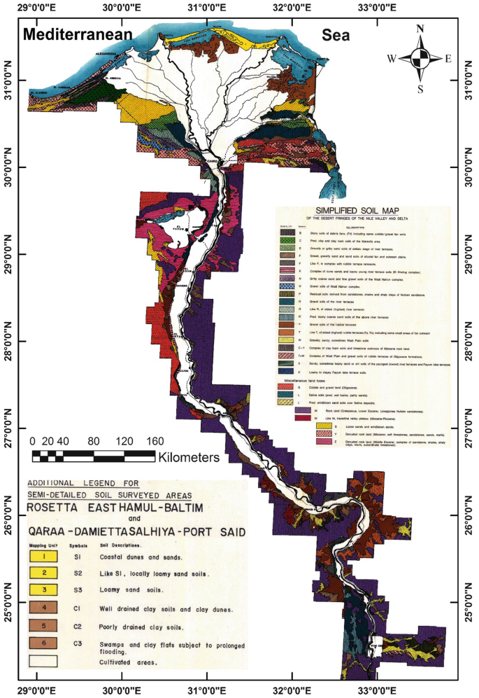
Simplified soil mapping units adjacent areas of the delta and valley [77]

However, the delta soils were divided into eight mapping units based on soil data and surface terrain database [79]: (1) Sandy to clay soils, high salinity, slope 2% – Aquolic Salorthids. (2) Sand dunes. (3) Sedimentary marine, clay, high salinity – Vertic Ustifluvents. (4) Fine clay, high salinity, slope 1% – Typic Ustifluvents. (5) Sand, high salinity, slope 2% – Typic Torripsamments. (6) Clay, non-saline, slope 1–2% – Typic Torrerts. (7) Sandy loam, non-saline, slope 1–2% – Typic Torrifluvents. (8) Clayey, high salinity, slope 2% – Typic Salitorrents. Figure 20 shows the soil mapping units adjacent areas of the delta and valley [77].
The laboratory analyzes showed that the Delta soil ranging from light to heavy clay, and that the percentage of clay ranging from 40% in the south to about 70% in the north (Fig. 21a). Most Delta soils are non-saline (Fig. 21b), but the salinity problem becomes more serious as we get closer to the sea, lakes, beach due to high groundwater level as a result of salty seawater and lakes nominated in the surrounding soils. Figure 21c shows the groundwater depth of Delta soils, where the groundwater depth of up to more than 150 cm in most of the southern part. The shallower northern part is near the coast and lakes. In general, the layers beneath the soil in the northern areas are wet, exhibiting the Mottling phenomenon, and have the gley horizon because of poor ventilation and poor drainage.

The morphological properties (a), soil salinity (b), and groundwater depth (c) of the Nile Delta [78]
5.2 The Soils of El-Faiyum Depression
El-Faiyum depression lies in the western desert of Egypt close to the Nile Valley with a distance of 40 km. It lies to the southwest of Cairo at a distance of about 90 km. The depression is situated between the altitudes 20° 34′ and 29° 2′, while the City of El-Faiyum – the capital – lies between 29° 18′ altitude to the north and 30° 50′ longitude to the east. The depression is bordered by Qattrani Mountain, to the south of the Libyan desert. On the eastern border, it is connected with the Nile by Bahr Hassan Wassif and the main desert highway (about 92 km) joining the northeast of the depression with Cairo (Fig. 22). The depression is surrounded by the Libyan desert except for a very narrow cultivated strip connecting it with the Nile Valley and with lake Qarun to the north. El-Faiyum depression has, in general, an extremely arid climate characterized by long dry and hot summers and short nearly rainless and cold winters [80]. The Nile water is considered the main source of irrigation in El-Faiyum by Joseph Sea. The water of agricultural drainage disposes in Lake Qarun while remaining part disposes in El-Rayan Valley (Fig. 22).

Landsat color image of El-Faiyum depression
El-Faiyum is a deep circular depression in the limestone of the northern part of the western desert. The soils of the area comprised in the El-Faiyum fan, the recent lake terraces, the old lake terraces, the older lake terraces, the depression edges, El-Faiyum plain, the Ghrak basin, and the old wadis. These soils have been developed from three types of parent materials, namely the Nile deposits, lacustrine deposits, and the calcareous deposits. Because of the differences in the nature of soil parent materials, these soils reflect different physical, chemical, and morphological characteristics. These soils are young and show weak horizon differentiation with the absence of diagnostic horizons other than salic, gypsic, and calcic horizons. Dominant pedogenetic processes are salinization, translocation of iron oxides, and probably transformation of minerals [81].
With regard to the main soil characteristics of El-Faiyum Governorate, many authors studied these properties [44, 80, 82,83,84,85,86,87]. El-Faiyum soils have divided into the following units [88]:
-
1.
Soils with diagnostic horizons, such as the salic horizon, gypsic horizon, and the calcic horizon, which include: (a) Fluvial sedimentary soil, and have accumulation of calcium carbonate horizon. (b) Soil containing gypsum and CaCO3 horizons, located near the eastern edge of the depression. (c) Soil with salic horizon, mostly on the coast of Lake Qarun, which is the lowest part in El-Faiyum, consists of fluvial deposits, high water table, salt crust on the surface, and most of which is not cultivated.
-
2.
Soils do not have diagnostic horizons, which include: (a) Sandy soils are at low edges and mostly not cultivated due to the high water level. (b) Fluvial sedimentary soils, occupy a relatively large area in the center of the depression, have silty sand to silty clay texture, low salinity, and a large part is cultivated with citrus and other.
-
3.
Heavy clay soils, most of low depression, consist of river sediment and salinity varies from region to region.
From the soil association map of Egypt [89], the Nile alluvium soils are the major in El-Faiyum depression as well as stony and loamy sand lithosols on rough to undulating denuded terrain that developed mainly from limestone. These soils could be grouped, in general, into Nile alluvial fluvio-lacustrine, residual regosols and lithosols (Fig. 23). The soil parent materials are of two kinds: transported or residual. In both types, there is not much difference and it is only confined to the formation of salic, gypsic, calcic, and gley horizons. El-Faiyum soils belong to the three orders vertisols, entisols, and aridisols. Abu El Einane [91] stated that the calcareous parent material is the prevailing arid climatic conditions and relief is mainly considered as the limiting factors affecting the soil forming development processes in El-Faiyum.

Geological map of El-Faiyum and surrounding areas [90]
Abdel Aal [92] studied the soils of different geomorphic features of El-Faiyum area. Morphological and analytical studies reveal that, on geomorphical basis, four geomorphic units El-Faiyum depression were recognized, namely (a) the El-Faiyum fan, (b) El-Faiyum plain including the flood and elevated features, (c) the El-Faiyum lake terraces including the recent, old, and older features, and (d) El Gharak basin. There exists a mutual relation between geomorphic aspects and either geogenic processes or pedological characteristics. Most of the soil properties can be interpreted by the climatic fluctuation between humid and arid conditions in both Pleistocene and Holocene. Therefore, some areas are characterized by recently formed and weakly developed soil without any diagnostic horizons due to the dominance of cumulization processes, which causes additions of new Aeolian or aqueous sediments under arid and humid conditions. Most of the studied soils are apparently formed from aqueous media, together with Aeolian origin, which was seemingly obvious in some localities lying on middle part (Faiyum fan) or at the edges of the depression (older lake terraces). The general conclusion, however, is that soil development as expected is weakly or not so pronounced, except for soil, which achieve some pedological diagnostic horizons. Hanna and Labib [93] showed that the soils located near the desert fringes of El-Faiyum depression are formed from fluvial-colluvial-aeolian sediments, while those near Qarun Lake are mainly formed from saline lacustrine deposits. They added that these soils have a sandy clay loam to loamy sand and clayey textures for the desertic formations and those near the Lake, respectively.
Soils adjacent to Qarun Lake include three geomorphic units, which are Nile alluvial deposits, desertic formation, and interference zone between lacustrine and desertic deposits. The soils south of Qarun Lake have been developed under arid conditions with different parent materials. Drainage played a major role in the soil formation through the effect on the soil salinization. In addition, Shendi [85] noted that the soil forming processes are salinization, calcification, alkalinization, illuviation, and gleization in these soil. The main soil forming factors in this area are parent material, climate, and topography. Studies of Kassem and Elwan [94] on these soils showed that these soils were developed under either stratified condition or multi-depositional regime. They also indicated that the amount and type of minerals assemblage reveals the origin of these soils, which could be related to lacustrine as well as post-lower Paleolithic Nile deposits.
The geographic location of the different soil types can be attributed to the distance to Qarun Lake in the northwest and thereby the frequency and severity of flooding [9]. Figure 24 displays the soil map of El-Faiyum. Vertic Torrifluvents are the dominant soil subgroup in El-Faiyum, covering an area of 760 km2 (43% of the study area). Other important subgroups are Typic Haplocalcids (421 km2, 24%) and Typic Torrifluvents (141 km2, 8%). The rest of the soil subgroups (Typic Haplogypsids, Typic Haplosalids, and Typic Torripsamments) are found in small areas and all together cover approximately 11% of the study area. Most of the cultivated soils in El-Faiyum province are deep Nile alluvial loam to clayey soils. In addition, calcareous clayey and a part from the sandy soils are found as patches in the depression edges. A general discussion of such types was provided by Shendi [85] who classified the soil types in this area in five major units: Nile alluvial soils, fluvio-lacustrine soils, fluvio-desertic soils, lacustrine soils, and desert soils.

Soil map of El-Faiyum [95]
The main identified soil deposits in El-Faiyum depression are: (a) Nile alluvial, (b) fluvio-lacustrine, (c) fluvio-desertic, (d) recent and old lacustrine, and (e) aqueous and Aeolian desertic formation. Nile alluvial deposits are mainly occupied the eastern-south and middle parts of El-Faiyum depression. Fluvio-lacustrine deposits occupied a large area, which exists in the eastern and southern rims of Qarun Lake. The general mineral assemblage and ratios of resistant minerals may be interpreted the heterogeneity of the parent materials, which prior to inception to geogenetic weathering, as well as the contribution of a basic source rock. It is rich in the ferro-magnesium minerals, together with the Nile suspended matter in forming a multi-origin profiles. Fluvio-desertic deposits occupied a small area at the outer rims of El-Faiyum depression, especially the western and eastern ones. Representative soils are characterized by heterogeneity nature of the parent materials; therefore, these deposits possess quite different textural classes that reflect the fluctuation in the lithological and environmental conditions during the profile formation. Recent lacustrine deposits are located at the present shoreline area of Qarun Lake. The frequency distribution of minerals and ratios of resistant minerals within the profile layers indicates multi-depositional stages, as well as a multi-origin profile and advanced stages of geochemical weathering. The suite of minerals of the old lacustrine deposits reveals that these deposits are subjected to an intensive chemical weathering for a long time and formed under multi-depositional regimes. Aqueous desertic deposits are located in the northern-east area. Unique depositional and mineralogical features that are differed from those of Nile and El-Faiyum deposits characterize these deposits. Aeolian desertic deposits occupied the northern-east and west area. These deposits are mainly derived from acidic plutonic rock with a little contamination from a metamorphic source rock. Also, these deposits have a relatively low index figure, an elementary weathering stage, almost uniform origin, and similar depositional environments [96].
From the study of soils that covered the main fluctuation in the environmental conditions of El-Faiyum, Awadalla [97] explained the mode of soil formation, soil origin, and profile uniformity. The soil deposits are of a poorly sorted nature, indicating that these sediments are mainly transported and deposited in aqueous media by water agent. The exception condition of the uppermost layers at fluvio-desertic formation soil exhibits an improvement in sorting coefficient, as it is qualified as a moderately well sorted or moderately sorted nature, indicating the combination effect of the Aeolian deposits, which transported by wind from the adjacent desertic formation. The assemblage and frequency of heavy minerals identified in the soil sediments developed on the Nile alluvial denote the low value of the index figure and the moderate content of parametamorphic minerals. These deposits are originated from igneous and metamorphic rocks, mostly related to Abyssinian plateau, basaltic-Sudan, and granitic-Aswan regions. However, soil sediments of both recent lacustrine and fluvio-lacustrine, which are dominated by ferromagnetism silicate minerals together and less pronounced amounts of parametamorphic ones, may be due to a basic source rock. Also, the high values of both index figure and opaques together with moderate content of ferro-magnesium minerals in the deposits of old lacustrine soil may have stress on their calcareous in nature, as well as, the possibilities of enrichments from a basic source rock. Concerning the deposit of the fluvial-old lacustrine, obtained data indicated a moderate content of ultra-stable minerals (zircon, rutile, and tourmaline) that occurred in the surface layer, which confirms the characters of the Aeolian desertic formation. Regarding uniformity ratios and weathering values, results obtained indicate that soil sediments of Nile alluvial, recent lacustrine and desertic formation soils exhibit an apparent homogeneity.
5.3 Lake Nasser Area
Lake Nasser (22° 31′–23° 45′ N and 31°30′–33°15′ E) reached its operating level of 175 m (asl) in 1975, with a total amount of 121 × 109 m3 of stored water. Lake Nasser is a vast reservoir in southern Egypt and northern Sudan. Lake Nasser refers only to the much larger portion of the lake that is in Egyptian territory (83% of the total). Lake Nasser is currently the largest man-made lake in the World. The region around the reservoir is a potential area for land reclamation and new settlements, urgently needed by Egypt’s expanding population [98]. Lake Nasser (Fig. 25) has a number of side extensions known as khors. All khors have a “U” shape in cross section, with a flat sandy central belt. There are 100 important khors in Lakes Nasser and Nubia combined. Their total length when the lake is full is nearly 3,000 km and their total surface area is 4,900 km2 (79% of total lake surface). In volume, they contain 86.4 km3 water (55% of total lake volume). Khors Allaqi, Kalabsha, and Toshka are the largest [99].

Map of the High Dam (Lake Nasser) soils
The soils, which lie on a level between 180 and 200 m above sea level, were described only, because the soils that fall under this may be attributed to the submerged during the flood season, and thus these soils were excluded. The parent materials of these soils are wadis sediments, shales, and Nubian sandstones [100]. On the western side of the lake, soils each of Karkar, Kalabsha, Aldka, Sarah, Toshka, Abu Simbel, and Adindan have consisted mainly of sandstone and shales. The soils of the Wadi Allaqi side east of the lake were established from igneous and metamorphic rocks.
Karkar valley is the Nuba part west of Lake Nasser and runs until the Sinn El-Kedab Plateau (Fig. 26) bordering the valley from the west. The plateau extends to south Kharga with the area of 800 km2 and a height of 180–550 m. The soils consist of different parent materials such as sandstone, limestone, clay, and sand transported by wind. The sandy soils are dominant in the region with a low content of salt.

The geomorphological units of the Lake Nasser area and adjacent areas in southern Egypt [101]
Kalabsha is located south of the Aswan City about 75 km. It extends from the Sinn El-Kedab Plateau (Fig. 26) in the direction of the northwest of Lake Nasser. Kalabsha Khor holds the lower part of the Valley Kalabsha, starts from Lake Nasser, and extends towards the west for a distance of 10.5 km with an average width of about 3 km. It is divided into two branches: the northern branch continues its extension towards the northwest for a distance of 5.5 km with an average width of 1 km, and the southern branch continues its extension towards the southwest for a distance of 11.5 km with an average width of about 1.1 km.
There are between Kalabsha and Aldka Kaolin mine (Kaolinite-mineral), with thickness ranges from a few centimeters to over 5 m, covering these deposits a thin veneer of wadis deposits. Some single hills exist such as Marawah Mount (270+ m). Soft sediments found in a low circular shape like Aburihwa Playa, located north of this Marawah Mount, with an area of about 30 km2. The soil texture is often clay loam with a thickness of about 10 m.
Sarah Khor soils are located on the western bank of Lake Nasser, and lie about 350 km south of Aswan, which is part of the plain of Lower Nubia. There are some sand dunes and rocky bumps on the surface in some locations, and there are hills and plateaus separate (Mesas) of the Nubian. Many wadis cut the area in which the most important and the longest are Sarah Khor.
Toshka (Fig. 27) is Nubian word with two syllables. The first is “Touche,” which is a plant that grows in depression, “Key” meaning home or place. Toshka means plant or flowers places [102]. The Toshka area is the first sites to gather the population in the desert, by prehistoric man, and the region of archaeological value, including the effects of and information about the origin of human civilization. Many dry valleys cut surface of Lower Nubia, which discharged, into the lake, and the valleys are Toshka and Wadi Aldka, where the headwaters are located in the plains of Nubia. The region is surrounded by hills in some parts of the Nubian Sandstone, where hilly landscape forms a hierarchical area shape or continuous sandstone ridges.

A map showing the flood of Toshka in the desert
Shallow sandy soils occupy part of the region, while the deep sandy soils occupy relatively small areas. Most of the soils (sandy or shallow sandy) are less than 50 cm depth. The shallow sandy soil area of about 89,000 acres. The surface is covered with small size pebbles, low salinity, which rarely exceeds 1.3 dS/m. The amount of CaCO3 ranges from 1.1 to 4%, and up to 15% or more in the some sites [103]. While the deep sandy soils occupy a small area (13,000 acres), small gravel on the surface, very low salinity (<1 dS/m), and few CaCO3.
The dominant clay minerals [100] in the Lake Nasser consist of kaolinite, montmorillonite, illite, and chlorite, but the kaolinite is dominant in sandstone soil, a good kind of crystallization (well crystalline), while the transported sedimentary soils have weak crystallization kaolinite.
The Adindan soils are located in the far south of Egypt, where the Egyptian–Sudanese border. Many valleys cut the region including Khor Adindan. The following soils are identified:
-
1.
Deep sandy soil (11,448 acres) of which the soil surface is covered with a thin layer of sand, gravel, and mixed soils. Soil salinity ranges from 6 to 11 dS/m and CaCO3 ranges from 2 to 14%.
-
2.
Medium deep sandy soil (19,788 acres) ranges from 50 to 100 cm of which soil surface is covered by desert pavement, mixed with gravel sand. Salinity is ranging from 7 to 10 dS/m and CaCO3 ranges from 7 to 14%.
-
3.
Shallow sandy soils (2009 acres) at the depth of 50–25 cm, with some of fine layered, rock Nubian sandstone at depths close to the surface. The salinity ranges from 3 to 11 dS/m, and CaCO3 ranges from 2 to 14%, being depending on location.
-
4.
Very shallow sandy loam soils (15,605 acres) at the depth of 25 cm. It is bounded on the bottom of the Nubian, mixed with gravel with sand through the layers of the soil at different rates depending on the location. The salinity ranges from 7 to 61 dS/m and CaCO3 ranges from 3 to 7%.
5.4 Evaluation of the Soils from Lake Nasser to the Delta
Although the Nile Valley and delta soils occupy the smallest region in the country, Egyptian peoples depend on these soils for agriculture and food since thousands of years. According to the soil association map of Egypt (Fig. 7) [89], there are five soil types: (a) Nile alluvium that formed the soils of the valley and delta except of its northern part, (b) salt affected soils of the lower Nile Delta areas, (c) salt marshes of the lower delta plain, (d) sandy clay loam with calcareous crusts and sand dunes of the delta lacustrine complexes, and (e) gravels and gravelly sand soils of deltaic phase with sand dunes in the eastern and western sides of delta. Alluvial soils are constituted by river sediment deposits that formed from the disintegration of the eruptive and metamorphic rocks of the Ethiopian plateau through physical, chemical, and biological weathering processes.
5.4.1 Soils Surrounding of Lake Nasser
The soils surrounding of Lake Nasser, i.e., Kalabsha, Tushka, El-Dakka, Abu-Simble at the western side of the lake and Allaqui area on the eastern side (Fig. 28) were formed as a result of water action while wind action is neglected [100]. In addition, the parameters show that Wadi soils are heterogeneous and stratified, while sandstone has a degree of uniformity. Wadi soils are composed of subrounded grains; this may be related to the distance of transportation. The origin of the clay minerals varies according to the lithological origin of soils. Kaolinite could be diagenetic formed in sandstone rocks and inherited in soils. Smectite may be derived from mica in the soils at the western side of the lake, while from mica or volcanic ash at the eastern side. Chlorite of Wadi Allaqui soils was most probably derived from the primary chlorite of the drainage basin of Wadi Allaqui. Illite may be formed because of changes on mica. Abu Al-lzz [37] reported that the Nile river terraces on both sides of the valley formed from sediments belonging to the Pliocene and Pleistocene. The Pliocene sediments in the southern part of the valley between Kum-Umbu and Beni Suef comprise of conglomerates, gravel, and sand. Those are distributed in some parts of the valley between Pleistocene and Holocene sediments of the floodplain and the two scarps bordering the valley. The Pleistocene deposits comprise of sand and gravel originating in the Red Sea Mountains. Moreover, the formation of the river terraces is related to three main factors, namely changes in base level, changes in water volume and load, and changes in the hydrographic system of the Nile.

Geological map of Lake Nasser area and adjacent areas south of the valley [101]
5.4.2 Aswan: Qina Soils
Soil formation of the Nile alluvial in Upper Egypt (ldfu at Aswan and Nag Hammadi at Qina) was investigated by Wahab et al. [104]. Soils features and subsequently their formation are deeply affected by the origin of their parent material (fluvial and colluvial origin). The major part of the valley soils is of fluvial origin. The soils near the western and eastern desert fringes are of fluvial-colluvial origin due to the continuous addition of colluvial and Aeolian sandy materials from the near desert. The effect of man on the soil formation in this area could be identified in the formation of an Ap horizon in the cultivated soils due to old cultivation and addition of organic manures. The presence of high underground water table in some soil profiles is generally associated with the formation of gley and natric horizons.
Studies of Sawy et al. [105] on the soils of the eastern area of the Nile river at Qena government showed that the different deposits occurred in this area are alluvial deposits (Island and river bank deposits, and floodplain deposits), alluvial colluvial deposits (relatively high and low parts), desertic deposits (relatively high, moderately high, low parts), and dry valleys. The soil texture is mainly affected by distance from the main Nile river course, the slope and relief, and the landform. However, the desertic soils differ in their texture due to the differences of their parent materials. The CaCO3 fractionation showed that the highest amounts occurred in the finer fractions in the alluvial soils of the Nile river valley and interference zone (alluvial-colluvial soils), while the opposite is true for desertic soils. The former is mainly due to the secondary form of CaCO3 in alluvial soils and the finer transported particles in the interference zone, while the latter is due to the products of the physical disintegration of desertic deposits, which are rich in CaCO3 content.
5.4.3 Nile Terraces at Assiut Soils
Faragallah and Essa [106] studied the soils of the Nile terraces at Assiut and found that the origin of these soils derived from different provenances, i.e., the acidic and basic igneous and metamorphic rocks, which are related to the igneous and metamorphic rocks of Ethiopian Plateau. In addition, the presence of calcite mineral in these soils suggests their derivation from lime-rich plateau surrounding the Nile Valley during their transportation and soil formation. The abundance of relatively unstable minerals, i.e., pyroxenes epidotes, amphiboles, micas, and feldspar suggests that these soils are young and weakly developed and/or recent deposition. These soils were stratified and/or mostly formed under multi-sedimentation regimes. The soil stratifications of the studied Nile terraces could be attributed to the variable water conditions occurred during their transportation and sedimentation together with the effect of the paleo-topography. The abundance of the relatively unstable minerals such as epidotes, amphiboles, pyroxenes, and feldspars (plagioclase, microcline, and orthoclase) in the alluvial soils of the Nile Valley and the interference zone between the desert and the valley at Assiut suggests that these soils are young and weakly developed. The presence of opaques, pyroxenes, and rutile reflects basic igneous rocks; the sphene, zircon, apatite represent the acidic igneous rocks; the epidotes represent the metamorphic rocks, and the amphiboles, biotite, tourmaline as well as garnet represent igneous and/or metamorphic rocks. The characterization of the sand fractions suggested that the deposition mode was by one source, namely Nile River water.
5.4.4 Kalubiah Governorate Soils
Soils of Kalubiah government are mostly formed from the Nile alluvium deposits, while some soils are developed over sub-deltaic deposits or over a mixture of wind-blown sand and calcareous deposits. Soils of recent Nile alluvium are usually clayey except the soils adjacent to the Nile River and the main canals which having a medium texture (loam or clay loam). Soils are developed on sub-deltaic deposits located in Shebin El-Kanater District and they consist mainly of coarse sand. Soils of calcareous deposits mixed with wind-blown sand are located in El-Khanka District. Soils that irrigated with sewage water for a long time are well developed, where horizons are easily recognized. (a) Horizon is friable and free of CaCO3, whereas (b) horizon is compact because of the cementation of CaCO3 and gypsiferous material. However, soils irrigated with Nile water are young. Horizons are weakly developed as showed in the Nile alluvial soils [107]. From soil development studies of some zones between the Nile Delta and the desert in the same government, there are clear differences between the older soils (Typic Torrerts), the recent soils (Vertic Torrifluvents, Typic Torrifluvents, Typic Torriorthents, and Typic Torripsamments), and Aridisols (Typic Calciorthids). Soils of Typic Torrerts had developed more than the other soils of Entisols and Aridisols [108].
5.4.5 Eastern and Western Side of the Nile Delta Soils
Some soils representing the main geomorphic units in the eastern (young deltaic plain, old deltaic plain, fluviomarine plain, wadi El-Tumulat, and the structural plain) and western (young deltaic plain, old deltaic plain, fluviomarine plain, alluvial deposits of desert wadi, and inland dunes) sides of the Nile Delta were evaluated by Morsi [109]. From the grain size parameters, the data of sorting Skewness and Kurtosis reveal that water and wind or both share together in the sedimentation of the soils. The sediments forming the investigated soils are mostly deposited under aqueous environment. Moreover, soils constituting each profile are heterogeneous either due to their multi-origin or due to the subsequent variation along the course of sedimentation. Therefore, they are still considered young from the pedological viewpoint.
At the end of the Pliocene period and during the formation of river terraces in the Nile Valley, the river was depositing great amounts of sand and gravels in the Mediterranean forming the delta base. These old sediments have almost disappeared under the new alluvium and are accordingly called sub-deltaic soils. Some of the sediments that have relatively high relief appear on the surface a sandy island underlying the recent fine silt and clay deposits. They occur in small scattered areas mainly in the eastern side and in the south central part of the delta. Sub-deltaic soils are distributed between 30°–31° N and longitudes 31°–32° E [37]. The application of the morphological rating scale on the cultivated and uncultivated sub-deltaic soils indicates that the cultivated soils are relatively more developed than the virgin ones especially in the surface layers. The deposits in the virgin areas as well as in the deepest layers of cultivated soils are mainly due to both water and wind actions. The water action is the common effective factor in the transportation and deposition of the surface layers in cultivated soils. Virgin soils seem to have one homogenous parent material and one origin, while the cultivated soils have apparently stratified layers of multi-origin [110]. Sandy hillocks within the recent alluvial soils of the Nile Delta constitute the distinguished phase of the old sub-deltaic deposits, which occupy considerable areas, especially in the south of the central and eastern parts of the Nile Delta. These deposits comprise the parent material of the sub-deltaic soils, which have a very different nature from the recent alluvial soils. The surrounding interference zones soils are characterized by a gradual change, from the sand texture (the sub-deltaic soils) to the clay texture (the recent alluvial soils) through the development of pedon characteristics.
Data of the study of the soil terraces on both sides of Ismailia canal, east delta shows that these terraces are of very poorly sorted nature transported in a rolling and suspension and deposited in an aqueous medium and characterized by the fine materials derived from fluvial origin, but non-uniform in nature. The soils located along the north and south Ismailia canal between Tell El-Kebier and Ismailia are the river terraces of fluvial origin, occupying the former Wadi El-Tumillat. The stratified conditions observed in most cases are mostly attributed to local changes during sedimentation together with the side effect of the natural formation closed to such terraces. The heavy minerals assemblage in the soil terraces indicate that these soils are weakly developed. Soils of the terraces are formed of either multi-origin or multi-depositional regime, due to the heterogeneity of the parent materials prior to inception to geogenetic weathering or resulted in from the geochemical weathering prevailed in the source sediments [111].
Soil formations in the area located at the eastern part of the Nile Delta, between 30° 18′ and 31° 42′ N and longitudes 31° 40′ and 32° 5′ E, are of different sources. The western part is from the Nile alluvium deposits. To the east, the soil becomes finer due to the effect of the Aeolian sand deposits. The northern part is mostly of fluviomarine deposits. The topography of the area plays an important role in soil formation through its elevation differences and the nature of its slopes. The mineral assemblages are characterized by an abundance of iron ores, pyroxenes, amphipoles, and epidotes. The slight difference in frequencies than that of the main Nile sediments is related to the relative increase in the frequencies of the iron oxides, metamorphic, and ultra-stable minerals, which are thought to be derived from the Oligocene and younger sediments exposed to the east and south of the area. Additions to these fluviatile sediments from another source rocks took place possibly by wind as evidenced from the much lower index figure than that of the Nile sediments, and the presence of rounded to subrounded frosted quartz grains. Due to the prevailing aridity in the area, the mechanical weathering is dominant. Uniformity and weathering ratios indicate that the top layers have been subjected to a relatively higher weathering than in the subsoils. In conclusion, the mineral suites of the examined soil have been resulted from the mixing of the Nile sediments and the older sediments in the area, the provenance is considered an igneous and metamorphic complex [112].
The salt efflorescence occurs covering the surface of most the soils of fluviomarine marshes located at the eastern site of the Nile Delta as well as on the western site of the Suez Canal coupled with gypsum formation and shell remnants. This is due to high water table and salinity of these soils that are adjacent the southern border of El-Manzala Lake. The soils of fluviomarine marshes and depressions contain high contents of CaCO3 and gypsum especially in the lower layers and this could be attributed to the marine origin of these stratified layers, i.e., lacustrine deposits. These soils have shallow salic horizon; however, the majority of the soils of the plains and deltaic stage of the river terraces does not have any diagnostic horizon in the upper 1 m [113].
5.4.6 Northern Zone of the Nile Delta Soils
The soils of the northern zone of the Nile Delta are characterized by the presence of four main geomorphic units: (1) Nile alluvial deposits, (2) fluvio-lacustrine deposits, (3) coastal barrier plains, and (4) coastal sand dunes [114]. The northern part of the Nile Delta that extends 170 km along the coast of the Mediterranean Sea from Damietta branch in the east to Edku Lake in the west, with 60 km inland from the coastal shoreline in the north to the old cultivated lands in the south localities was studied by Hagag [115]. The clay fraction of soils of Nile alluvial deposits is dominated by montmorillonite, kaolinite that are mostly inherited from parent materials (alluvium). Soils of fluvio-lacustrine are sandy clay loam which contain some calcareous and dominated by the montmorillonite, hydrous mica, kaolinite, and palygroskite. These soils come from the original matter (fluvio-lacustrine deposits). Concerning the soils of coastal barrier plains are loamy sand, which contains a high percentage of CaCO3 and salts and dominated by the montmorillonite, mica, kaolinite, vermiculite, and palygroskite. These deposits come from the pedogenic or inherited from parent origin sediments derived wholly or in part, from lacustrine or calcareous. However, the soils of coastal sand dunes are loamy sand and contain a moderate percentage of CaCO3 and salts. These soils are formed by Aeolian and marine deposits. The effect of the low topography appeared by the effect of the salinity and the marine nature of the depositions on the clay minerals which exist especially in the coastal barrier plains. These conditions helped to turn the original clay minerals to mixed layers as a transformational stage. In addition, the effect of the high topography appeared in the sand dunes movement and the creping of sands from north to south played an important role in the distribution of clay minerals. The depositional environment which formed the area contains the soils of Nile alluvial plains formed by Nile deposits materials, but the soils of fluvio-lacustrine, though derived from two different parent sediments, namely lacustrine and alluvium. The soils of the coastal barrier plains formed by the sea, and so the soils of coastal sand dunes formed by the Aeolian and marine deposits.
Khater and Mansour [116] reported that the grain size image of the soil sediments in the northern part of the Nile Delta between Damiatia and Rossitta cities showed that the transporting agent and environment of deposition were mainly fluviatile in nature, except for the beach sandy sediments, which have dual sources between the water and wind action, i.e., related to Aeolian and fluviatile environment. The beach sandy sediments contain a relatively high content of heavy minerals due to the influence of Aeolian sea sediments. Degree of minerals weathering is mainly affected by the drainage conditions of the soils. The soil materials were originated from basaltic rocks of Sudan, igneous and metamorphic rocks of Abyssinian plateau, and granitic rocks of Aswan region. Most of the soil sediments have quite different features due to lithological discontinuity, which is indicated by the distribution of minerals within the successive layers of studied soils. This difference in distribution is attributed either to heterogeneity of parent material or to a more advanced stage of weathering. Most of the sediments in the area are of multi-origin or formed due to multi-depositional regimes.
Elmaaz [117] studied some soils adjacent to lakes at the north of Egypt and found the soils of recent Nile alluvium, marine alluvium, and desert plain have mainly heavy texture (clay), whereas the others of sub-deltaic and sandy beaches are lighter (loam). These soils are non-saline to moderately saline and total carbonate content varies widely from one profile to another. Many lime concretions and broken shells especially in the downstairs layers of profiles south of Lake Mariout. The different statistical size parameters indicated that the most soil materials of recent Nile alluvium, marine alluvium, and desert plains deposits are poorly sorted with platy to very platy kurtic pattern, this indicates that the water is the main factor responsible for transportation and formation of soil materials of these deposits. The cumulative curves of these soils are nearly similar and symmetrical reflecting almost uniform and homogenous soil materials. However, results of sub-deltaic and sandy beaches deposits indicate that their soil materials are formed under a combined effect of water and wind action. Their soil materials are nearly heterogeneous and formed under different depositional regime. Most soils are considered young from the pedological point of view. The majority of recent Nile alluvium, marine alluvium, and desert plain are formed under similar depositional regime. The soils of other landforms are deposited under multi-depositional regime. Abu-Agwa and Amira [118] stated that the soils adjacent to Borullus, Manzala, and Qarun salty lakes differ from sandy loam to clay texture affecting mainly by natural sedimentation pattern and circumstances of each area. The soils situated close to the lakes have moderate horizontation may be due to the intermixing between recent alluvium and lacustrine deposits in these areas.
The alluvial salt affected soils, the northern part of the Nile Delta were investigated in governorates of El-Beheara (Ferhash and El-Lakana), Alexandria (Abees), Kafr El-Sheikh (Burg Megasal and Shalma), Damietta (Kafer Soliman El-Bahri), El-Dakahlia (Mear Meraga salcil), and Sharqia (El-Monaga El Kobra and El-Tal El-Kebir) [119]. The obtained results showed the significance of the Mediterranean Sea water, Lakes, and groundwater as sources of salinity to adjacent soils. However, the action of seasonal wetting and drying under the environmental arid climate and the low elevation from surrounding areas adds some extra salts to these soils. Soils were categorized as saline soils, saline alkali soils, and alkali soils. Generally, most of the salt affected soils of the Nile Delta are of the saline alkali nature [120]. The study of soil morphology and sedimentation pattern showed that these soils vary in their components in different locations based on soil relief, the Nile, sea, lakes, and western and eastern desert deposits. Accordingly, the different sediments of these parent materials interfere with each other, but in different deposits rates in the different locations [119].
Abo El-Ennan et al. [121] studied the genesis of clay minerals in some saline and alkaline soils in the northern part of the Nile Delta. They stated that the clay minerals of the investigated soils could have been carried either by the Nile River from its upper sources or formed in situ by the weathering of primary silicates. Smectite, kaolinite, and illite minerals may have been transported in the suspended matter carried by the Nile. The presence of interstratified clay minerals in some soil samples may be explained by pedogenic formation and transformation processes. An inadequate drainage system and a high water table possible promoted such a transformation. The soils are influenced by saline water and relatively high temperature, which enable the alteration of the lattice framework of the clay minerals. These soils have high Mg/Ca or Na/Ca ratios because of the inadequate drainage system and seepage of saline water from the Mediterranean Sea and the northern lakes. Seawater rich in Mg-ions leads to the transformation of hydrous mica into montmorillonite whereas the K-ions between the layers have been replaced and due to this the attractive forces were weakened and water molecules entered the lattice resulting in its expansion.
6 Conclusions and Outlook
This chapter however, brings to light the land and water resources development in the Nile Valley and Delta. Analysis of the hydrogeological features of the Nile Delta starts from the recognition that surface and groundwater are tightly intertwined. Nile Delta branches (Rosetta and Damietta) gain water from the aquifer in some reaches and lose water to the aquifer in other reaches. The flow directions between groundwater and surface water can change seasonally with variations of the water table level with respect to the level in nearby waterways. Available data on the evolution of the salinity of groundwater in the Delta indicate that the construction of the High Aswan dam resulted in a shift of salinity isolines towards the seashore (because of a constant supply of water year round), and that current pumping rates have not yet critically affected this balance (but more recent data are needed to analyze the evolution in the past 10 years). Possible localized over-pumping, however, results in “up-coning” of salinity from deeper layers. This preliminary review on groundwater in the Nile Delta has also shown that contamination of groundwater by agriculture and more prominently by seepage from domestic and industrial effluents had already attained worrying levels. This may jeopardize the quality of the Nile Delta aquifer in the long run and requires more research and attention.
The future study should be focused on cases where underground reservoirs or aquifers are overused. The increasing use of groundwater for irrigation poses a serious threat to food security and could lead to unaffordable prices of staple foods. Recent hydrological modelling and Earth Observations have located and quantified alarming rates of groundwater depletion, which is due to water withdrawals for irrigation. Aquifer depletion can also induce significant environmental degradation, such as land subsidence and seawater intrusion. Studies of water resources embedded in food trade – virtual water trade – have sometimes distinguished between blue water (surface water and groundwater) and green water (soil moisture) sources, which can provide additional information on the potential environmental impact of their use. Globally, countries irrigating crops from over exploited aquifers export them in various proportions. Eleven percent of groundwater extraction for irrigation is linked to agricultural trade. India keeps most of its large GWD-based crop production for domestic use (only 4% of GWD exported), while the USA, Pakistan, and Mexico export significant portions of their GWD-based crop production (42%, 26%, and 23%, respectively). The major importers of GWD via crops include China (9% of global GWD trade), the USA, Iran, Mexico, Japan, Saudi Arabia, Canada, Bangladesh, UK, and Iraq. Individual crops contributing most to global GWD transfers are rice (29%), followed by wheat (12%), cotton (11%), maize (4%), and soybeans (3%). Citrus crops and sugar crops account for 5% of GWD transfers each.
In Egypt, which is irrigation-intense country, agriculture is the leading user of groundwater, making up more than 80–90% of withdrawals. There is not sufficient precipitation or surface water available to grow crops like maize or rice and so farmers use water from the underground to irrigate. Based on the current chapter, the amount of non-renewable groundwater used for irrigation was doubled in Nile Valley and Delta. The annual groundwater abstraction in the Nile aquifer system and fringes is about 4.6 billion m3. Another 0.5 billion m3 is abstracted from the desert aquifers and the coastal areas. Groundwater abstraction is expected to increase to 11.4 billion m3. Model output revealed that groundwater recharge has not changed significantly over time, while pumping has. Because of these trends, groundwater was estimated to be in a deficit of approximately 24 billion m3 (±15%) in 2011, compared to 1957.
Crops such as rice, wheat, cotton, maize, and sugar crops are most reliant on this unsustainable water use. Egypt was locally most affected due to groundwater depletion and exporting agricultural products grown with non-sustainable groundwater. When a country imports maize grown with this non-renewable water, it virtually imports non-renewable groundwater. Therefore, groundwater overuse rising could hit food prices. Putting water labels, along the lines of food labels is important for creating awareness. These labels show how much water is used domestically and internationally in the production and whether these water amounts are from sustainable or non-sustainable sources. Water labels and caps on extraction, linked to agricultural trade, are among measures proposed tackling the trend.
References
CAPMAS (2016) Central Agency for Public Mobilization and Statistics. http://www.capmasgoveg/
Tamburelli P, Thill O (2013) The Nile metropolitan area. Berlage-Institute, TU Delft
Kantoush SA (2013) The downstream impacts of Ethiopia’s Cascade dams in the upper Blue Nile on Egypt. Proceedings of regional sustainable building conference SB13 Cairo Fairmont Towers Hotel Cairo, Egypt
El-Din MMN (2013) Climate change risk Management in Egypt proposed climate change adaptation strategy for the Ministry of Water Resources & Irrigation in Egypt. UNESCO Office, Cairo
CAPMAS (2012) Central Agency for Public Mobilization and Statistics. http://www.capmasgoveg/
Wahaab R, Badawy M (2004) Water quality assessment of the River Nile system: an overview. Biomed Environ Sci 17:87–100
Elnashar W (2014) Groundwater management in Egypt. IOSR J Mech Civil Eng (IOSR-JMCE) 11(4):69–78
El Arabi N (2012) Environmental management of groundwater in Egypt via artificial recharge extending the practice to soil aquifer treatment (SAT). Int J Environ Sustain 1(3):66–82
Said R (1993) The River Nile; geology, hydrology and utilization. Pergamon Press, Oxford
Hozaien S (1991) Egyptian civilization. Dar Al Shorouk ISBN: 9770900252
Awad M (1998) The Nile River. Egyptian General Book Authority
Beaumont P, Blake G, Wagstaff J (1988) The Middle East: a geographical study. David Fulton, London
Elarabawy M, Attia B, Tosswell P (2000) Integrated water resources management for Egypt. J Water Supply Res Technol AQUA 49:111–125
Lonergan S, Wolf A (2001) Moving water to move people. Water Int 26:589–596
Harms JC, Wray JL (1990) Nile Delta. In: Said R (ed) The geology of Egypt. A.A. Balkema, Rotterdam & Brookfield, Vermont, pp 329–343
Toussoum O (1922) Memire sur les annciennes branches du Nil. Imprimeric d’Instit Francais Epoque ancienne TIVD’archeologie Orientale cairo
Shahin AAW (1978) Some of the geological phenomena in the Nile Delta. Arab Geogr Mag (11):9–26
Stanley DJ, Warne AG (1993) Nile delta: recent geological evolution and human impact. Sci Technol 260:628–634
Hamdan G (1984) The personality of Egypt. Dar Al Hilal
RIGW (1992) Groundwater resources and projection of groundwater development. Water Security Project, (WSP), Cairo
Morsy WS (2009) Environmental management to groundwater resources for Nile Delta region. PhD thesis, Faculty of Engineering, Cairo University, Egypt
Aquastat (2013) FAO http://www.FAO.org/nr/water/aquastat/irrigationmap/egy/index
Al-Agha DE, Closas A, Molle F (2015) Survey of groundwater use in the central part of the Nile Delta. Water and salt management in the Nile Delta: Report No 6
RIGW (2003) Impacts of future surface water development on groundwater aquifer system in the West Nile Delta Region, Cairo
MWRI (2005) National Water Resources Plan for Egypt 2017. Ministry of Water Resources and Irrigation
Sherif M (1999) The Nile Delta aquifer in Egypt. Chapter 17 in seawater intrusion in coastal aquifers, concepts methods and practices. In: Bear J, Cheng A, Sorek S, Ouazar D, Herrera A (eds) Theory and application of transport in porous media, vol 14. Kluwer Academic Publishers, Dordrecht, The Netherlands, pp 559–590
Sefelnasr A, Sherif M (2013) Impacts of seawater intrusion in the Nile Delta Aquifer, Egypt. Ground Water 52(2):264–276. National Groundwater Association
MWRI (2012) Strategy of water resources of Egypt till 2050. Ministry of Water Resources and Irrigation
FAO (2013) Monitoring of climate change risk impacts of sea level rise on groundwater and agriculture in the Nile Delta
Zaghloul MG (1985) Flow distribution through groundwater aquifer of the Nile Delta. MSc thesis, Faculty of Engineering, Alexandria University, Egypt
Amer A, Sherif M (1996) An integrated study for seawater intrusion in the Nile Delta aquifer. WRSR publication series no 14, NWRC, MWRI, Egypt
Diab MS, Dahab K, El Fakharany M (1997) Impacts of the paleohydrological conditions on the groundwater quality in the northern part of Nile Delta. The geological society of Egypt. J Geol 4112B:779–795. Cairo
Fadlelmawla A, Dawoud MA (2006) Protection areas at the Nile Delta. Egypt J Environ Manage 79(2):140–149
Saleh MF (1980) Some hydrogeological and Hydrochemical studies on the Nile Delta. MSc thesis, Faculty of Science, Ain Shams University
Mabrouk MB, Jonoski A, Solomatine D, Uhlenbrook S (2013) A review of seawater intrusion in the Nile Delta groundwater system – the basis for assessing impacts due to climate changes and water resources development
Abd El-Fattah EM (2014) Evaluation of the environmental and chemical impacts of banana plantation on the groundwater aquifer in the southern part of nile delta and its vicinities. PhD thesis in Environmental Science University of Sadat City, Egypt, 190 p
Abu Al-Izz MS (1971) Land forms of Egypt. The American University in Cairo press, Dar Al Maaref, Cairo, Egypt
Attia MI (1954) Deposits in the Nile Valley and the Delta Mines and Quarrie Department. Geological Survey, Egypt, Cairo, p 356
Farid MSM (1980) Nile Delta groundwater study. MSc thesis, Cairo University
RIGW/IWACO (1990) Hydrogeological inventory and groundwater development plan, Western Nile Delta Region. Main Report, vol 4, Technical Note 7701300–90-02RIGW, 64 p
Abu-Zied M, Abdel-Dayem G (1991) Sail load in irrigation and drainage water in the Nile Delta. In: African Regional Symposium on techniques for environmentally sound water resources development
Fattah M, Ragab E (2014) Assessment of groundwater vulnerability to pollution in the southern part of Nile Delta, Egypt. Stand Sci Res Essays 2(13):725–738
Mohamed MAE (2002) Study of groundwater development in the Western Delta by using the remote sensing and GIS. Msc thesis, Faculty of Engineering, Ain Shams University, Egypt
Khater A, Fadlelmawla A, Fekry A (2002) Assessment of groundwater quality in El Sadat City and proposed action for groundwater protection. Proceedings of the III international symposium on environmental hydrology American Society of Civil Engineering & Egyptian Society of Irrigation Engineering, Cairo, Egypt
Abd el Salam M (2004) Remedial solutions for the impacts of the existing groundwater development plan in Western Nile Delta. Second regional conference on Arab Water, action plans for integrated development
El Fakharany ZMA (2002) Management of conjunctive use of surface water and groundwater. Msc thesis, Helwan Univerisity, Faculty of Engineering, Mataria, Egypt
Darweesh WMK (2001) Optimal management of underground water in west delta zone. PhD thesis, Faculty of Engineering, Ain Shams University
El-Beshri MZ, Labadie JW (1994) Optimal conjunctive use of surface and ground water resources in Egypt. International water resources association VIII IWRA world congress on water resources, Cairo, Egypt
Dawoud M, Darwish M, El-Kady M (2005) GIS-based groundwater management model for western Nile Delta. Water Resour Manag 19:585–604
Molle F, Rap E, Ezzat Al-Agha D, Ismail A, Abou El Hassan W, Freeg M (2015) Irrigation improvement projects in the Nile Delta: promises, challenges, surprises. Water and salt management in the Nile Delta project report no 4 IWMI, WMRI, Cairo
Mohamed RF, Hua CZ (2010) Regional groundwater flow modeling in Western Nile Delta, Egypt. World Rural Observ 2(2):37–42
Switzman H, Coulibaly P, Zafar A (2015) Modeling the impacts of dryland agricultural reclamation on groundwater resources in Northern Egypt using sparse data. J Hydrol 520:420–438
Samak SAMA (2007) Groundwater management in delta. Msc thesis, Faculty of Engineering, Zagazig University, Egypt
Todd DK, Mays LW (2005) Groundwater hydrology. 3rd edn. Wiley, New York, NY, pp 589–606
Atta SA (1979) Studies on the groundwater properties of the Nile Delta, Egypt. MSc, Faculty of Science, Cairo University, Cairo
Farid MSM (1985) Management of groundwater systems in the Nile Delta. PhD thesis, Cairo Univ, Giza, Egypt
Sherif M, Sefelnasr A, Javadi A (2012) Incorporating the concept of equivalent freshwater head in successive horizontal simulations of seawater intrusion in the Nile Delta aquifer, Egypt
Leaven MT (1991) Hydrogeological study of the Nile Delta and adjacent desert areas, Egypt, with emphasis on hydrochemistry and isotope hydrology. MSc thesis, Free University, Amsterdam also published by RIGW/IWACO as technical note TN 7701300-91-01
Ebraheem AM, Senosy MM, Dahab KA (1997) Geoelectrical and hydrogeochemical studies for delineating ground-water contamination due to salt-water intrusion in the northern part of the Nile Delta, Egypt. Ground Water 35(2):216–222
Sakr SA, Attia FA, Millette JA (2004) Vulnerability of the Nile Delta aquifer of Egypt to seawater intrusion. International conference on water resources of arid and semi-arid regions of Africa, Issues and challenges, Gaborone, Botswana
Sharaky M, Atta SA, El Hassanein AS, Khallaf KMA (2007) Hydrogeochemistry of groundwater in the Western Nile Delta aquifers, Egypt. 2nd international conference on the geology of Tethys, Cairo University
Masoud A (2014) Groundwater quality assessment of the shallow aquifers west of the Nile Delta (Egypt) using multivariate statistical and geostatistical techniques. J Afr Earth Sci 95:123–137
Ghoraba SM, Zyedan BA, Rashwan MH (2013) Solute transport modeling of the groundwater for quaternary aquifer quality Management in Middle Delta, Egypt. Alex Eng J 52:197–207
Salem MG, El-Awady MH, Amin E (2012) Enhanced removal of dissolved iron and manganese from nonconventional water resources in Delta District. Egypt Energ Procedia 18:983–993
Hussien MM (2007) Environmental impacts of new settlements on the ground water in a region in Delta. Msc thesis, Zagazig University, Faculty of Engineering, Egypt
Ghanem AHM, Zaghloul AS, El-Ayouti S (2011) Groundwater lowering in multi-layer aquifer systems: case study of Esna City – Egypt. A paper presented at the 64th CWRA National Conference, “Our Water – Our Life – The Most Valuable Resource,” in St John’s NL Canada, June, 2011
El-Fakharany Z, Fekry F (2014) Assessment of New Esna barrage impacts on groundwater and proposed measures. Water Sci 28(1):65–73
Faid AM (2003) Interpretation of goelectrical data to identify aquefers and pale-channel of river Nile in Esna area, upper Egypt. Sci J Fac Sci Minufiya Univ XMI:89–118
Ismail A, Anderson N, Rogers D (2005) Hydrogeophysical investigation at Luxor, Southern Egypt. J Environ Eng Geophys 10(1):35–49
Selim S (2009) Hydrogeochemical assessment of groundwater at the area between Wadi Qena and Wadi El-Mathula, Upper Egypt. Sci J Fac Sci Min ujia Univ XXIII(2):81–101
Abdalla F, Ahmed A, Omer A (2009) Degradation of groundwater quality of quaternary aquifer at Qena, Egypt. J Environ Stud 1:19–32
Esam I, Abdalla F, Erich N, Hermann M (2012) Comparison of the groundwater quality in the West Tahta Area, Upper Egypt in 1989 and 2011. J Environ Prot 03:1442–1457
El Tahlawi M, Abo-El Kassem M, Baghdadi G, Saleem H (2016) Assessment of groundwater vulnerability – a case study. Int J Adv Rem Sens GIS 5(2):1561–1579
Waleed SS, Abd El-Monaim AE, Mansour MM, El-Karamany MF (2009) Evaluation of groundwater aquifer in the area between El-Qusiya and Manfalut using vertical electric soundings (ves) technique. J Eng Sci Assiut Univ 37(5):1193–1207
Salem A (2015) Hydrogeological studies on the shallow aquifers in the area West Samalot, El-Minia Governorate, Egypt. Egypt J Pure Appl Sci 53(4):49–60
Gedamy Y, El-Aassar A, Abdel-Gawad A (2012) Pollutants detection in water resources at El Saff Area and their impact on human health, Giza Governorate, Egypt. Int J Environ 1(1):1–14
FAO (1965) Simplified map of the desert fringes of the Nile Valley and Delta. High Dam Soil Survey Project Ministry of Agricultuie
El-Nahal MA, Abd El-Aal RM, Aid El-Wahed AA, Raafat I (1977) Soil studios on the Nile Delta. Egypt J Soil Sci 17(1):55–65
Rahim SI (2006) Compilation of a soil and terrain data base of the Nile Delta at Scale 1:100000. J Appl Sci Res 2(44):226–231
Ghabbour TK (1988) Soil salinity mapping and monitoring using remote sensing and a geographical information system (some applications in Egypt. PhD thesis, Fac of Sciences, State Univ of Ghent
Abu El-Einane SM (1985) Pedogenesis of the Fayoum area PhD thesis, Fac of Agric, Al-Azhar Univ, Cairo, Egypt
Khater EA (1973) Pedological studies on Fayoum Governorate, A.R.E. MSc thesis, Fac of Agric, Cairo Univ, Egypt
Abdel-Hady MA, El-Kassas IA, Ayob AS (1982) Automatic classification of lake Qarun water by digital processing of land sat Mss data. In: Proceeding of the international symposium of remote sensing of environment first thematic conference: remote sensing of arid and semi-arid lands, Cairo, Egypt, pp 1143–1165
Abd El-Aal TS (1984) Pedological and physical studies on some soil of the expansion areas in Fayoum Governorate, Egypt. MSc thesis, Fac Of Agric, Cairo Univ, Egypt
Shendi MM (1984) Pedological studies on soils adjacent to Qarun lake – Fayoum Governorate – EGYPT. MSc thesis, Cairo Univ, Egypt
El-Naggar MA (2004) Land Evaluation of some soils in Arab Republic of Egypt. PhD thesis, Fac of Agric, Moshtohor, Zagazig University, Banha Branch
Harun MRO (2004) Soil evaluation systems as a guide to identify an economical feasibility study for agricultural purposes in El-Fayoum Governorate. PhD thesis, Fac of Agric Cairo University, Egypt
Hamdy H (1982) Soil map of Egypt. Final report academy of scientific research and Technology – ASRT, Cairo, Egypt
Hammad MA (2011) Soil association map of Egypt. Updated legend The Soil Survey Institute Wageningen the Netherland & Digitized by AAAbdel-Ghany SWR ARC Giza Egypt
Said R (1962) The geology of Egypt. El-Sevier Publishing Company, Amesterdam, NY
Abu EI Einane SM (1977) Pedology and geomorphology relationship in EI Fayoum governorate. MSc thesis, Fac of Agric, AI Azhar Univ
Abd El-Aal TS (1990) Cyclic formation of soil on different geomorphic features of Fayoum area. Egypt. PhD thesis, Faculty of Agriculture at Fayoum, Cairo University, Egypt
Hanna FS, Labib FB (1977) The soils of the Fayoum depression. Egypt J Soil Sci 17(1):33–43
Kassem YS, Elwan AA (1980) Origin and uniformity of the soils adjacent to Qarun lake, Fayoum Governorate. Egyptian J Soil Sci 20(1):57–63
Shendi MM (1990) Some mineralogical aspects of soil sediments with special reference to both lithology and environmental conditions of formation in Fayoum area, Egypt. PhD thesis, Facof Agricat El-Fayoum, Cairo University, Egypt
USDA (2010) Keys to soil taxonomy. United State Department of agriculture: natural resources conservation service (NRCS), 3rd edn
Awadalla AA (1998) Studies on the main soil pedogenic aspects in El-Fayoum depression as related to the dominant soil formation processes. PhD thesis, Fac of Agric at Fayoum, Cairo University, Egypt
Abu Zeid M (1987) Environmental impact assessment for Aswan High Dam. In: Biswas AK, Geping Q (eds) Environmental impact assessment for developing countries, London, pp 168–190
El-Shabrawy MG (2009) Lake Nasser–Nubia. In: Dumont HJ (ed) The Nile: origin, environments, limnology and human use, © Springer Science + Business Media BV
Reda M (1978) Some pedological features in some arid soils of Egypt. PhD Fac Agric Al-Azhar Univ
DRS and LERI (1999) Land resources South Valley and Toshka South Valley and Toshka. Desert Research Center and Land and Environment Research Institute. Encyclopedia Volume II
Saleh I (1998) Project Toshka, Human – Investment – Development. Family Library
Abdel-Salam AM, El-Kadi HA, Reda M (1974) Soils of wadi kalabsha (Lake Nasser region). The Regional Planning of Aswan and the Desert Institute
Wahab MA, Hanan FS, Hady F, Abdel Samie AG, Hamdi H (1972) Studies on the formation of some soils in the Nile Valley. Egypt J Soil Sci 12(1):31–40
Sawy S, Magd MH, Hanna F, Abd El-Hady AA (1990) Physiography and soil map of the eastern area of the River Nile at Qena governorate, Egypt. Egypt J Soil Sci 30(3):457–479
Faragallah MA, Essa MA (2011) Sand and clay mineralogical composition in relation to origin, sedimentation regime, uniformity and weathering rate of Nile terrace soils at Assiut, Egypt. Aust J Basic Appl Sci 5(10):239–256
Boctor S, Abo Gelayel AMA, Yaeoub EW, Ibrahim AM (1979) The soil classification of Kalubiah governorate, Egypt. Agric Reach Rev 57(5):147–163
Mousa AM, Naguib BH, Khalil MA (2000) Soil development studies of some zones of encroachment between the Nile Delta and the desert in Qalubeya governorate. J Agric Sci Mansoura Univ 25(10):6567–6583
Morsi MA (2003) Pedological studies on the soil located in the eastern and western sides of the Nile Delta. PhD thesis, Fac of Agric, Zagazic Univ (Benha Branch), Egypt
Amira MS (1996) Pedological, mineralogical studies and evaluation of sub-deltaic soils in the Nile Delta, Egypt. Minufiya I Agric Res 21(1):237–253
Noaman KI (1989) Origin, mode of formation and uniformity of soil terraces on both sides of Ismailiya canal, east Delta, Egypt. Egypt J Soil Sci 29(2):121–131
Khail JB, Noman KI (1980) Mineralogical studies on the sand fraction of the river terraces, and its relation to soil genesis, in the eastern part of the Nile Delta. ARE Desert Instil Bull 30(1):81–97
Gobran OA, Abou Agwa FE, Shehata RB (1992) Morphology, physical and chemical changes associated with physiographic units of selected soils in Egypt. Egypt J Soil Sci 32(2):265–286
FAO (1963) The semidetaile soil survey. High Dam Soil Survey, UAR 111 (Report, 16)
Hagag AA (2005) Mineralogical composition of the clay fraction, in relation to lithology, topography and depositional environments in the northern coastal zone of the Nile Delta. Zagazig JAgric Res 32(1):125–142
Khater E, Mansour A (1985) Texture characterisics and mineral composition the main soil sediments in the northern part of the Nile Delta, Egypt. Bull Fac Agric Univ Cairo 36(1):467–474
Elmaaz EIM (2005) Pedological and mineralogical on soils adjacent to some lacks at the north of Egypt. PhD thesis, Fac of Agric, Minufiya Univ, Egypt
Abu-Agwa FE, Amira MS (1998) Characteristics and evaluation of soils adjacent to salty lakes in Egypt. Minufiya Agric Res 23(4):111–1128
Kandil MF, Hanna F, Abd El-Aal SI (1980) Diagnostic features of Egyptian salt affected soils in the Nile Delta. Agric Reach Rev 58(4):115–133
Kandil MF, Hanna F, Abd El-Aal SI (1980) Sources and natures of the salinity and alkalinity in the salt affected soils of the northern part of Nile Delta, Egypt. Agric Reach Rev 58(4):99–114
Abo El-Ennan SM, Salem MZ, MM EL-B (1990) Genesis of the clay minerals of some soils in the Nile Delta, A.R.E. Egypt. Soil Sci 30(3):445–456
Author information
Authors and Affiliations
Corresponding author
Editor information
Editors and Affiliations
Rights and permissions
Copyright information
© 2017 Springer International Publishing AG
About this chapter
Cite this chapter
Omran, ES.E. (2017). Land and Groundwater Resources in the Egypt’s Nile Valley, Delta, and Its Fringes. In: Negm, A. (eds) Groundwater in the Nile Delta . The Handbook of Environmental Chemistry, vol 73. Springer, Cham. https://doi.org/10.1007/698_2017_64
Download citation
DOI: https://doi.org/10.1007/698_2017_64
Published:
Publisher Name: Springer, Cham
Print ISBN: 978-3-319-94282-7
Online ISBN: 978-3-319-94283-4
eBook Packages: Earth and Environmental ScienceEarth and Environmental Science (R0)