
Abstract
Maritime spatial planning aims to provide an integrated governance framework for the rational allocation of activities whilst also preserving marine ecosystems. Maritime spatial planning is a complex task with similarities to but also significant differences from onshore spatial planning. The sea is a multidimensional environmental, economic and social territory, so the methods and methodologies used for classical land-use planning can vary. The management of the coastal zone, which is the link between the land and the sea, is critical. The adoption of European Union Directive 2014/89 has led to the creation of a new national legal framework for the preparation of maritime spatial plans in European Union member states, including Greece. However, the complexity of the interactions between anthropogenic pressures and the marine ecosystem makes it essential to quantitatively assess the impact of the land uses included in proposed local spatial plans. Thus, the cumulative impact score index (Ic) was used to assess the pressures on the coastal environment caused by the land uses proposed in the local spatial plan for the Mastichochoria area of the island of Chios in Greece. Based on the results of the case study, the authors argue that quantitative analytical tools are required for comprehensive and effective planning, especially within the ecosystem approach framework. The results indicate that an integrated approach between onshore and offshore institutional spatial planning is required, and that a new, more effective spatial governance model is needed in Greece.
Introduction
During the last few decades, maritime spatial planning has been the subject of extensive dialogue at the European and international levels (e.g. Zaucha and Gee 2019; Wassenhoven 2017; Kyvelou 2016), while the spatial planning of coastal zones (Ahlhorn 2018) and the development of coastal communities (Mega 2016, 2019) have received particular attention. The framework for the preparation and monitoring of such plans has drawn significant interest. Buhl-Mortensen et al. (2017) proposed a generic framework for the monitoring and evaluation of spatially managed maritime areas that was tested in 13 European countries. Jones et al. (2016) carried out 12 case studies of European countries and used the results to design a well-structured, qualitative, empirical approach to delivering concrete maritime spatial planning policies. Papatheochari and Cocossis (2016) proposed a framework for the monitoring and evaluation process to use when implementing and reviewing a maritime spatial plan. Abramic et al. (2018) investigated whether the implementation of the INSPIRE Directive (European Union Directive 2007/2/EC) improves and strengthens the information management and data infrastructure required to establish maritime spatial planning processes. Following a similar approach, Pınarbaşı et al. (2017) presented a thorough review of the current use of decision support tools for MSP implementation processes around the world. They also identified weaknesses of and gaps in existing tools, and proposed new ways to improve the feasibility and promote the application of those tools.
European Union (EU) Directive 2014/89 (European Union 2014) states that maritime spatial planning is the most suitable tool for ensuring the effective management of marine activities and the sustainable use of any marine or coastal resource. This Directive is part of the EU Integrated Maritime Policy, and has explicit synergies with the Marine Strategy Framework Directive and other EU policies that promote the adoption of an ecosystem-based approach. It also identifies maritime spatial planning as a cross-sectoral policy instrument that enables public authorities and stakeholders to adopt an integrated approach that ensures maritime policy implementation. The final objective of the Directive is to use maritime spatial planning as an interdisciplinary tool to coordinate EU sectoral policies affecting seas, islands, coastal areas and marine activities based on the pillars of sustainable development.
Directive 2014/89 has driven many EU member states to develop maritime spatial plans (MSPs) and incorporate them into their national legal frameworks in an effort to shape effective policies for developing and regulating the marine environment. However, progress in the maritime spatial planning process varies significantly among EU member states (Kyvelou and Pothitaki 2016).
Interdisciplinarity is a fundamental component of spatial planning, especially in member states that are characterized by serious spatial planning deficiencies, such as Greece (Lazoglou and Angelides 2016). Maritime spatial planning is of paramount importance in Greece, as it is a relatively new topic in this country. This subject is currently at the forefront of scientific dialogue in Greece due to the ongoing formulation of the terms, conditions, structures and principles it must address. Areas of particular interest have been the adaptation of blue growth policy in Greece (Kyvelou and Ierapetritis 2019) and the interaction of coastal and marine environments (Cocossis and Beriatos 2016), emphasizing various issues such as socioeconomic dimensions (Niavis et al. 2016), landscape integration (Tsilimigkas et al. 2018), and facilities such as offshore wind farms (Vagiona and Karanikolas 2012) and wave-energy systems (Vasileiou et al. 2017). Another interesting research question was investigated by Papageorgiou and Pozoukidou (2014), who proposed a basic spatial typology of traditional settlements based on geospatial and environmental characteristics, focusing in particular on the islands of Crete, the Cyclades, and the Dodecanese, among others. They also proposed three levels of protection, as reflected in a number of restrictions and guidelines for each type of settlement.
Overall, the complexity of the interactions between anthropogenic pressures and the marine ecosystem makes it essential to quantitatively assess the impact of the proposed land uses in local spatial plans (LSPs). Therefore, in the work we report in the present paper, the cumulative impact score index (Ic) was used to assess the pressures on the coastal environment induced by the proposed land uses in the LSP for the Mastichochoria area of the island of Chios in Greece. We argue that quantitative analytical tools such as this are required to facilitate comprehensive and effective planning, especially within the ecosystem approach framework.
Maritime spatial planning and land–sea interactions
A key challenge for maritime spatial planning is to ensure an appropriate balance between development pressures and environmental protection and also to address the rational allocation of human activities and their interactions among each other (Wassenhoven 2017). However, the sea does not constitute a strictly defined area; it is a field of competition between various actors across national, regional, and other administrative borders. Sustainable development—the intergenerational conservation of resources—should be considered a prerequisite for this process.
Moreover, important notions for onshore spatial planning such as territorial cooperation acquire different meanings, requirements and priorities in marine spatial planning. Therefore, marine spatial planning is considered a complex task, as the strong anthropogenic pressures faced by the marine environment make it imperative to protect the sea against any kind of potentially irreversible damage, particularly to marine ecosystems (Wassenhoven 2017).
When devising solid and concise policies that facilitate the sustainable use of the sea, EU member states are expected to take into account various and complicated economic, social and environmental parameters, because there are various sea-based human activities that can damage the marine environment. The quality of maritime spatial planning is directly related to the prioritization of objectives, the effective utilization of the knowledge available and democratic decision-making. Moreover, to achieve efficacious spatial planning policies, it is important to follow a continuous process of formulation and coordination (Hajer et al. 2010).
Maritime spatial planning presents similarities to but also reasonable differences from onshore spatial planning (Wassenhoven 2017). For instance, since the sea has no inhabitants, there are no private property rights, although there are exploitation rights (i.e. exclusive economic zones). On the other hand, human activities can occur in all dimensions of the sea (i.e. at the surface, in the water column, on the seafloor, on the seabed and at different times), infrastructure is not depended on population density, international or transnational conditions may be applied, and so on. This complexity is mainly related to the multiple dimensions of the sea.
A critical aspect to consider is the interaction between the marine environment and the coastal zone—the physical link between land and sea, which should not be regarded as two separate zones but rather as one dynamic area that requires a special methodological approach (European Environment Agency 2006). This approach is not a recent one. The United Nations Convention on the Law of the Sea (UNCLOS 1982), a key reference report for marine spatial planning, states that measures should be taken to deal with all sources of pollution in the marine environment, including those from land-based sources (Article 194). One of the first related studies, the Land–Ocean Interactions in the Coastal Zone (LOICZ) project, was established in 1993 in the framework of the International Geosphere-Biosphere Programme (IGBP). A subsequent project (2004–2014) focused more on the human dimensions of the coast, addressing hotspots of coastal vulnerability (Ramesh et. al 2015).
More recently, two related projects were elaborated in the framework of the European Observation Network for Territorial Development and Cohesion (ESPON). The ESaTDOR project (University of Liverpool 2013) examined territorial development opportunities and risks in European seas, while MSP-LSI (University of Liverpool 2019) produced guidelines for both MSP and onshore planning agencies on how to manage land–sea interactions (an analytical framework for land–sea interactions is provided by Kidd et al. 2019).
Interactions between the land and the sea can be broadly grouped into two categories: biogeochemical processes and socioeconomic activities. It should be noted, however, that these categories are closely interrelated (Kidd et al. 2019). Pressure on the coastal environment can result from a wide range of land-based activities, including agriculture and urban growth (which can have a profound impact on the marine environment; e.g. via runoff of chemicals/waste; Directive 2014/89/EU) and the degradation or destruction of habitats by human activities, which are neglected in coastal area management (Wassenhoven 2017, p. 127). Marine life relies on good water quality, and the sea is the main sink for pollutants and sediments from land-based activities, exerting pressure on the health of marine and coastal ecosystems (University of Liverpool 2016).
According to a recent European Commission policy report (European Commission 2018), eight key sectors should be addressed when developing maritime spatial plans: aquaculture, desalination, fisheries, marine cables and pipelines, minerals and mining, ports and shipping, tourism and coastal recreation, and offshore energy. For instance, tourism can be a source of pollution, noise, disturbance to marine species and water quality degradation. Aligning marine and onshore planning is also important, and should be achieved through consistency of policies and plans. In European countries such as Lithuania and Germany, MSPs are integrated into onshore spatial planning through their inclusion in general land-use plans (e.g. Federal Plan of Mecklenburg-Vorpommern).
Integrated coastal zone management (ICZM) is directly related to the maritime spatial planning approach (Ramieri et al. 2019); they are considered complementary tools (1) geographically, as they often involve both onshore and offshore human activities, and (2) in terms of objectives, as maritime spatial planning includes the rational allocation and organization of human activities whereas ICZM promotes the integrated management of human activities to ensure the sustainable management of coastal zones (Asprogerakas et al. 2007). ICZM is primarily a governance scheme in which stakeholders are involved in ensuring continuous vertical coordination (between administrative levels) and horizontal coordination (between actors at a particular level) of policies and actions (for further analysis, see Ahlhorn 2018). Papatheochari and Coccosis (2019) provide a methodology for the development of a decision-making tool that explores local stakeholders' perceptions of actions that should be prioritized during waterfront development. Williams et al. (2006) proposed a methodology that integrates qualitative and quantitative data to estimate the net benefits of the application of ICZM at the European scale.
Achieving the EU objectives for integrated coastal zone management and maritime spatial planning requires a detailed knowledge of human activities and their impacts on environmentally sensitive habitats. Individual activities require relevant information that must be effectively organized to achieve synergies. For example, coastal area spatial planning requires a knowledge of erosion rates, sediment morphology and soil topography to determine whether protection or reclamation is the most appropriate coastline management approach (European Commission 2012).
This complicated task can be achieved through the ecosystem-based approach. The ecosystem-based approach does not necessarily follow specific pre-existing boundaries (e.g. administrative boundaries); rather, it seeks to divide marine spaces into individual units with similar ecosystemic characteristics (e.g. protected areas and restricted areas) (Lazoglou 2018) in order to promote the sustainable planning and development of anthropogenic activities (Douvere 2010; COMPASS 2005).
The ecosystem-based approach
The United Nations (UN) Convention on Biodiversity (United Nations 1992) defines the ecosystem-based approach as “a strategy for the integrated management of land, water and living resources that promotes conservation and sustainable use in an equitable way”, while humans (and their cultural diversity) are recognized as a key integral component of ecosystems. The conservation and sustainable use of biological diversity and its components should be addressed holistically after considering many socioeconomic and cultural parameters; however, the ecosystem-based approach should be the primary tool (United Nations 1995).
Τhe ecosystem-based approach to marine space planning is characterized by 12 complementary and interlinked principles (CBD 2004). According to the first three, the management objectives of land, water and living resources are a matter of societal choice (principle 1), management should be decentralized at the lowest appropriate level (principle 2) and ecosystem managers should consider the effects (actual or potential) of their activities on adjacent and other ecosystems (principle 3). The fourth principle refers to the need to understand and manage the ecosystem in an economic context. Also, ecosystems should be managed within the limits of their functioning (principle 6), and while change is inevitable, adaptation is an option (principle 9), pursuing the appropriate balance between the conservation and the use of biological diversity (principle 10). Maintaining the services of an ecosystem should be a priority in the ecosystem-based approach (principle 5), and the related objectives should be achieved in the long term (principle 8) and applied in the appropriate spatial and time frames (principle 7). According to the last two principles, the ecosystem-based approach should use any existing relevant information, knowledge, innovations and practices (principle 11) and involve all relevant parts of society and scientific disciplines (principle 12). Most of the problems encountered in biological diversity management are complex, with side effects and implications, and therefore should be tackled using all of the available expertise. Moreover, a wide participatory approach to forming, implementing and monitoring policies concerning the development and protection of an ecosystem is needed, engaging stakeholders at local, national, regional and international levels.
The Millennium Ecosystem Assessment (MEA) initiative in the 2000s attempted to identify the link between ecosystem change and human well-being. It aimed to propose a solid scientific framework for protecting and using the sea in a sustainable way (MEA 2005). The sea encompasses a wide range of ecosystem services that affect human well-being. The MEA established a framework for addressing various problems related to the sea, such as the impact of plastics on fish, water supply, water purification, climate change, floods, coastal protection, recreational opportunities and tourism.
The ecosystem-based approach has been adopted by the MSP Directive (2014/89/EU) and other related policies and initiatives undertaken under the auspices of the UNEP/MAP Barcelona Convention. The utilization of the ecosystem-based approach in maritime spatial planning results in a holistic approach that attempts to combine environmental and social objectives and ensure increased intersectoral communication and cooperation at various levels (Zervaki 2019; Wassenhoven 2017). It reflects ecological characteristics of both the marine and terrestrial components of the coastal zone (Westholm 2019), and may lead to a shift towards a wide participatory perception of sea management and monitoring (Zervaki 2019).
The reality is, however, more complicated, and although there is already widespread dialogue concerning legal and operational aspects of the ecosystem approach (e.g. Langlet and Rayfuse 2019), the best pathway for effectively implementing this approach is not yet apparent (Wassenhoven 2017, p. 156). Westholm (2019) questions the coherence of various definitions of the ecosystem approach within EU marine legislation, given that there is evidence (Jones et al. 2016; Merrie and Olsson 2014) that MSPs based on political expediency and blue growth priorities (see Chapter 3 in Kyvelou 2016), including marine protected area networks (Bastmeijer 2019), are diverging from the ecosystem approach.
The spatial planning system in Greece and the integration of maritime planning
Spatial planning and governance
The legal framework for urban and regional planning in Greece has been recently revised (L.4269/2014 and L.4447/2016) to make it more flexible and responsive. It provides two types of planning (Fig. 1): (a) strategic spatial planning is based on data analysis and anticipating future developments, and includes medium-term or long-term objectives, guidelines on spatial development and production activities, and protection provisions at national and regional levels; (b) regulatory spatial planning involves, for example, the establishment of land uses and the building ratio. There is a fundamental provision that lower-level spatial plans must be harmonized to the directions and priorities of approved higher-level spatial plans.

Source: present authors (2019)
Relationships between onshore and offshore spatial plans at various scales.
According to the administrative system (L. 3852/2010), the country is divided into seven state administrative regions (decentralized authorities) with specific planning powers. Below this, there are 13 elected regional authorities (the second tier of local government) and 325 local administrative organizations (municipalities—the first tier of local government). The role of municipalities in urban and regional planning is mostly advisory. The governmental executive power in the field of spatial planning lies mainly with the Ministry of the Environment and Energy.
EU Directive 2014/89 was incorporated into the Greek legal system through the introduction of Law 4546/18. This law established a modern national legal framework for maritime spatial planning in Greece that comprises the preparation of (a) the National Maritime Spatial Strategy (NMSS) and (b) maritime spatial plans (MSPs). According to Law 4546/18, maritime spatial planning “…is integrated into the existing spatial planning system and coordination and coherence between maritime spatial planning and onshore spatial planning is sought” (YPEN 2018).
The Ministry of Environment and Energy is responsible for implementing maritime spatial planning policies; it must “…supervise and coordinate programs and studies related to spatial planning implemented in the national marine and coastal area…” (Law 4546/18, Article 14, par. 1.θ). This follows the model used for onshore regional spatial plans, which should aid the swift adoption of the NMSS and MSPs (Wassenhoven 2017). However, the law does not provide or specify any specific tools that the Ministry of Environment and Energy should use for this purpose. This approach was criticized during the public consultation process for the law, considering the complexity of the marine environment, the large number of stakeholders and the range of administrative responsibilities involved.
A report evaluating the implementation of existing maritime spatial planning policies will be prepared by the Ministry of Environment and Energy every 5 years. It should be noted, however, that similar provisions for the onshore spatial planning system have been neither effective nor sufficient in the past.
The link between public administration and civil society during the preparation and implementation of the NMSS and MSPs is a crucial aspect of the Greek spatial planning system. Law 4546/18 aims for a wide participatory decision-making process followed by a similar public consultation procedure (according to Article 6 of Law 4048/2012). However, the general lack in implementing such practices in a substantial way in Greece, raises concerns about the effectiveness of this process (Wassenhoven et al. 2010; Serraos and Asprogerakas 2018). Key stakeholders may also actively participate in this consultation process through the National Council for Spatial Planning (Law 4447/2016), which is the supreme consultation body on important issues relating to both onshore and offshore spatial planning in Greece. In any case, any procedure followed should be based on the principles of equality, equity, transparency and representativeness in order to maximize participation in the preparation, implementation and monitoring of marine spatial planning policies and to identify possible synergies (Lazoglou 2018).
Assessing the implementation framework for maritime spatial plans
According to Law 4546/18 (Art.8), maritime spatial planning determines the distribution of existing and future activities in and uses of marine areas and coastal zones. This law also states that any activity which occurs either onshore or offshore and interacts with the coastal area of interest must be considered when preparing a MSP.
The National Maritime Spatial Strategy is a policy-making framework, while MSPs focus on the subregional, regional and even interregional levels (Law 4546/18, Art.6, Par.4), although these regions do not necessarily correspond to the boundaries of Greek administrative regions. The regulatory or strategic nature of the provisions that MSPs introduce is another crucial issue. However, the conditions and limitations on the various activities that MSPs specify should follow the principles of sustainable development, respect the carrying capacity of each geographical area, and facilitate the environmental protection, social cohesion and economic development of the area examined (Lazoglou 2018).
Law 4546/18 also attempts to determine the legal interactions between MSPs and onshore spatial plans, although there is no defined hierarchical relationship between the local spatial plansFootnote 1 (LSPs, Law 4447/16) and the MSPs. The local spatial plans must follow the provisions of the regional spatial plans, which are prepared for each Greek administrative region. The law states that any onshore spatial plan should assess the provisions of MSPs, but it does not describe how this will be ensured. However, this ambiguity could be circumvented by the Ministry of Environment and Energy, given that it is the body responsible for preparing both onshore spatial plans and MSPs in Greece, meaning that it can facilitate smooth cooperation between both types of plans in terms of priorities, tools and terminology. Environmental protection tools (such as those described by Law 1650/86 and Presidential Decrees relating to the protection of small coastal marine wetlands) as well as environmental assessment may be used to implement MSPs. Figure 1 describes the relationships between the spatial plans enacted at various scales (national, regional and local) in onshore spatial planning as well as the relationships between those plans, the NMSF and MSPs (Asprogerakas and Lazoglou 2018).
Impact assessment for the coastal and marine environment: evidence from Mastichochoria, Chios, Greece
Method
Although human impacts on the marine environment are readily apparent and can be systematically monitored, there is no easy way to assess and incorporate these effects in maritime spatial planning. Since 2008, when Halpern et al. published the report A Global Map of Human Impact on Marine Ecosystems, the cumulative impact score index (Ic) and several variants of it have been widely used to support marine spatial planning (Halpern et al. 2008). However, most of those studies have focused exclusively on the marine environment, only rarely considering the effects of human coastal activities on it (Holon et al. 2015; Micheli et al. 2013). In the case study reported here, Ic was used to identify the impact of land coastal uses/anthropogenic pressures proposed by the LSP on the coastal and marine environment. Because lc is sensitive to the weighting method used (Bevilacqua et al. 2018), appropriate weights were adapted from other studies (Ban et al. 2010; Teck et al. 2010). The spatial database used consisted of the locations of human activities (types of stressors), as described in the LSP, and marine habitats (where data were available). The cumulative impact score (Ic) was calculated via the following equation (Halpern et al. 2008):
where:
Di is the normalized value (scaled between 0 and 1) of the intensity of an anthropogenic driver at location i
Ej is the presence or absence of ecosystem j
µi,j is the impact weight for anthropogenic driver i and ecosystem j
m is the average impact score across ecosystems.
The index is a linear additive model, so its output range varies depending on the number of layers used. A classification for this index was proposed by Halpern, but a different classification method (quantile) was used for this case study in order to better evaluate the cartographic results.
Case study area
The cumulative impact index was applied to the southern part of the island of Chios in Greece as a case study. This area was selected based on a series of criteria: (a) the existence of different proposed coastal land uses, (b) data availability, (c) the existence of a recently elaborated LSP, and (d) the high seasonal tourist activity due to the international reputation of the schinos (mastic) tree. The area of Mastichochoria is located in the south of Chios; it has an area of 211.7 km2 and occupies 25% of the territory of Chios. Mastichochoria is in the Municipality of Chios, the Northern Aegean Region and the Decentralized Administration of the Aegean. This area is characterized by semi-mountainous and lowland areas, where the mastic tree is cultivated. Mastichochoria has a varied coastline with small rocky bays to the west and southwest. The altitude of the Mastichochoria region ranges from 100 to 350 m. The residential network of the Mastihochoria area consists of a total of 24 settlements, although many uninhabited islets can also be found in this area.
Significant ecosystems are located in Mastichochoria. The islet of Venetiko, located in the southern part of Mastichochoria, is on the list of the Natura 2000 network of protected areas (site code GR4130004) and is designated a Venetian Island. There are also the wetland areas of Elos Komis, Elos Fanon and Elos Lithi, which are on the list of Protected Small Island Wetlands of the Country. Moreover, the settlements of Mesta and Pyrgi, as well as the islet of Venetiko, have been identified as landscapes of particular natural beauty.
Since there is no official MSP for this area as yet, the current LSP was examined. The aim was to identify, quantify and map potential conflicts between the LSP, coastal planning and the marine environment. The LSP for Mastichochoria, according to the official principles and guidelines, determines land uses (tourism development, agriculture, etc.) in this area for the next 10–15 years, as well as the conditions imposed on each type of development. The effects of those planning decisions on the marine environment are not assessed in this framework, as LSPs are not obliged to extend beyond the coastal line. As a result, LSPs do not consider anthropogenic pressures when proposing coastal land development or restrictions beyond those that the institutional framework for protected areas (e.g. Natura 2000 areas) dictates.
Data collection and preprocessing
Each coastal/marine and land-based anthropogenic pressure was assigned a zone of impact based on previously cited literature, and a buffer was created (Table 1). The land-based pressures were obtained from the proposed land uses in the LSP. The four most dominant land uses/activities were selected: tourism development zones, human coastal settlements, agricultural land and fishing shelters. In this area, especially along some parts of the coast, seasonal tourism and leisure activities are significant. The exception is the valley of Dotia and the beach at Vroulidia, where schinos is widely cultivated (orange color in Fig. 2).

Source: present authors (2019)
Area considered in the case study, and land uses proposed in the LSP for this area.
Data on the marine environment were acquired through EMODNet (European Maritime Observations and Data Network). EMODNet offers immediate access to reliable information, open accessibility and interoperability (European Community 2012). Data layers from the Human Activities and Seabed Habitats portals were used. In particular, the following data layers were used in the analysis:
EUSeaMap (2019) broad-scale predictive habitat map (EUNIS classification codes A5.535: [Posidonia] beds and A5.38: Mediterranean biocoenosis of muddy detritic bottoms). These habitats were selected based on the European Red List of Habitats (Gubbay et al. 2016). The relevant dataset is shown in Fig. 3a.
Fig. 3 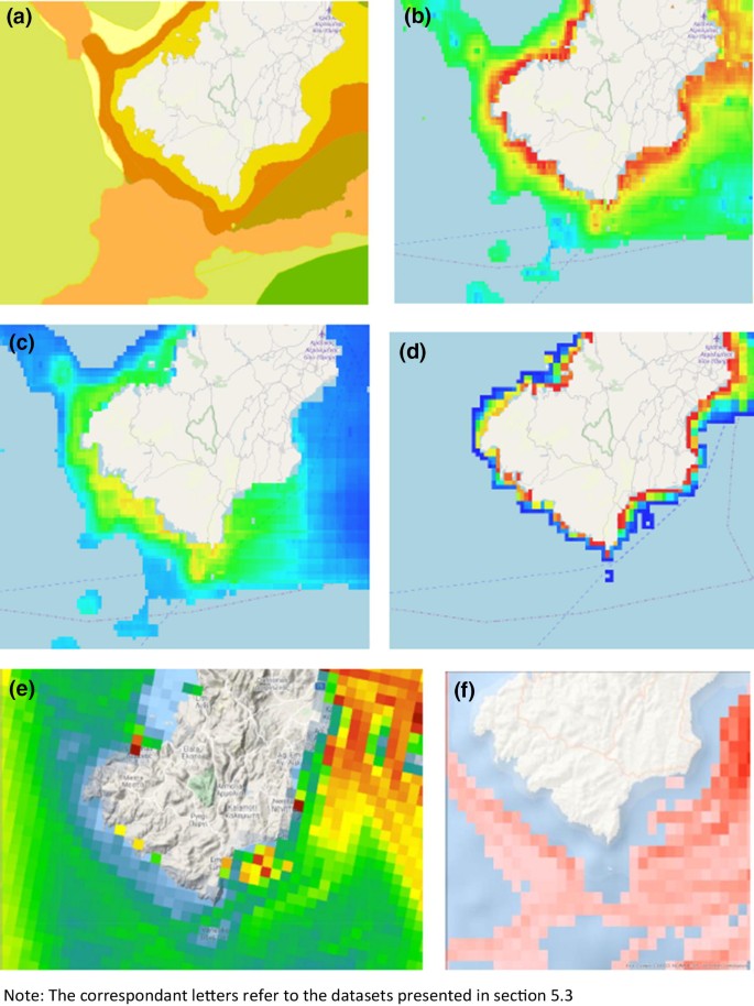
Source: present authors (2019)
Datasets for available human marine activities and seabed habitats. Letters refer to the datasets discussed earlier in this paper.
The following layers from the project MEDISEH: Mediterranean Sensitive Habitats were used:
Probability of a coralligenous habitat in the Mediterranean (Fig. 3b)
Probability of a maerl habitat in the Mediterranean (Fig. 3c)
Modelled probability of Posidonia oceanica meadows occurring across the Mediterranean Sea (Fig. 3d).
Only areas with probabilities of 75% or more were used in the analysis. More detailed information about the habitats can be accessed from the above portals.
The following layer from the human activities portal was used:
Vessel density (Fig. 3e).

Protected areas (Natura, wetlands and environmentally significant areas) were also added to the coastal and marine habitats. Finally, the fishing intensity raster for Europe from the JRC online data catalogue was used. The information used in this work was obtained from the automatic identification system (AIS)-derived high-resolution fishing effort layer for European trawlers more than 15 m long for the years 2014–2015. All of the above data sets were processed and calibrated for an integrated geospatial database. For the spatial analysis process, all data were converted to a pixel size of 1000 × 1000 m.
Application of the cumulative impact index
Only the locations of known human activities were used in the analysis, and the relative impact as well as the distance to which the effects of an activity extend were acquired through a literature review (Ban et al. 2010; Teck et al. 2010). The weights were adapted for this case study. Table 1 presents the datasets (habitats and human activities/anthropogenic pressures), the weights and the distances to which the effects of various human activities extend.
The results of the application of the Ic were mapped (Fig. 4). The values of Ic obtained varied from 0.2 to a maximum of 8.8. To categorize the results cartographically, the data range was divided into five categories using the quantile method. Each category had an equal number of pixels.

Source: present authors (2019)
Impacts of all human activities on individual habitats.
The map shows that the proposed uses in the LSP have a significant impact on marine habitats, especially in the red areas (with Ic values of > 2.7), demonstrating the need for marine spatial planning and coastal planning to act synergistically. High cumulative impact scores are generally due to the presence of multiple proposed uses because the index is linear additive, as previously mentioned. In this case study, even though only a few datasets were available, areas with very high Ic values covered more than 34% of the total area considered. This impact on the coastal and marine environment was not explicitly taken into consideration at any stage during the creation of the LSP. The results demonstrate that, even at a small scale, the land uses specified in a local plan can have a potentially significant impact on the marine environment. Although Ic is a simple index, it not only allows us to quantify and visualize the impact of land uses spatially (depending on the analysis of the original data sources), but it also provides a way to re-evaluate, re-think and re-plan the LSP. Using Ic data, planners can evaluate multiple planning scenarios and their effects on the coastal environment, thus enhancing both the MSP and the LSP. The results of this case study also demonstrate that the future of coastal and marine planning is much more complex than the future of land planning. The authors argue that this is a missing link in the national procedure for implementing local spatial plans.
Limitations of the case study
The datasets used here were derived from EMODNET and other open online databases. Although they have spatial limitations (coarse-grained analysis, lack of field data), they nevertheless represent the marine and coastal environments sufficiently accurately to demonstrate the main argument of the present work. It is evident that more data are needed to achieve more detailed and efficient coastal planning, but this case study was performed to highlight the impact of onshore planning on coastal and marine ecosystems and to prove our initial argument: that local spatial plans fail to account for coastal ecosystems and marine habitats.
Discussion and conclusions
The purpose of maritime spatial planning is to manage and organize marine activities and uses in a sustainable way. This process is complicated and is characterized by a multitude of specifics. Maritime spatial planning is complex, and the multifaceted nature of the problems examined requires any potential solution to them to be interdisciplinary. The need to rationalize the principles, priorities and objectives that shape the framework of decision-making has been recognized in the European policy-making process, and has already acquired an institutional character in the context of spatial policies through the establishment and development of the European Observation Network for Territorial Development and Cohesion in the 2000s.
In Greece, the interconnections between MSPs and the onshore spatial planning system should be identified clearly and concisely to avoid any legal or administrative confusion and prevent the formation of a parallel planning system that cannot facilitate the sustainable planning of marine and coastal areas. The implementation of MSPs should account for the particularities of each region (size, density, maritime uses, marine environmental vulnerability, administration), while the transition from onshore spatial planning to offshore spatial planning is critical and requires cooperation between the respective marine and land strategies and plans. This indicates that sufficient data, concrete in-depth analysis and detailed evaluation methodologies are required.
The establishment of a properly structured observatory could be one way to meet this challenge. The main tasks of such an observatory would be the formulation, coordination and implementation of marine planning policies. The utilization of state-of-the-art technological tools could significantly aid maritime spatial planning and management and the monitoring of any actions specified in the plan. The proposed observatory could also: (1) create a database/repository of geospatial information, (2) calculate relative indicators that would be used to monitor the implementation of marine spatial plans, and (3) collect, manage and organize various types of socioeconomic data concerning the NMSF and MSPs.
Impacts on the marine ecosystem, especially those caused by human activities, should be assessed via MSPs, and the resulting impact data should be fed back to spatial planning at a local level. Although the case study performed in this work had limitations regarding data availability and variety (as described in the previous section), it still demonstrated that the proposed LSP actions had quantifiable and differential impacts on coastal and marine ecosystems. The analysis performed also revealed that currently available tools, techniques and methods could significantly facilitate coastal and onshore planning initiatives. Moreover, it was concluded that human sea activities/anthropogenic pressures require an integrated coastal planning and management approach. A quantitative approach such as that proposed in this paper could provide the planners involved in delivering MSPs and LSPs with solid planning scenarios by quantifying the pressures caused by onshore and offshore land uses. Moreover, it could be used to monitor the implementation of the policies developed and provide feedback. This kind of support is needed not only to form and implement the planning policies but also by all stakeholders involved in spatial planning, who can take it into account when forming their ideas, beliefs and priorities.
Taking both the theoretical analysis and case study into consideration, the main tasks that must be incorporated into the spatial planning system in Greece in order to enhance maritime spatial planning are:
Dynamic investigation of land–sea interactions
The clarification of terms, conditions and principles that can be employed to formulate alternative models which can be applied to effectively organize the offshore spatial planning system in Greece
The codification of the key predictions of all of the spatial plans at the national and regional levels, the spatial impacts of important national sectoral policies (shipping, transport, etc.) and wider legislation (protected areas, etc.)
The identification of the key competencies and management responsibilities of each administrative level
The preparation of alternative scenarios based on the links between MSPs, the ICZM and existing plans (regional spatial plans, special spatial plans, LSPs, etc.)
The utilization of qualitative methods and techniques such as cumulative impact assessment (applied as in this case study, for example) as valuable tools for marine spatial planning based on an ecosystem approach, especially for coastal areas.
A useful framework for addressing the above issues is the spatial governance approach, which aspires to enhance the traditional spatial planning system (Wassenhoven et al. 2010; Kyvelou 2010). Spatial governance refers to an alternative model of collective space management that is an aid to decision-making in complex systems where there are extreme competing interests of actors. Stakeholder equality and participation, wide consultation, and bottom-up policy-making are among its main features. This approach can operate vertically (encompassing different administrative levels) as well as horizontally (incorporating different actors). Moreover, it can be used as a framework for coordinating sectoral policies with a spatial dimension, such as transport, the environment and tourism (Wassenhoven et al. 2010). Spatial governance has been used to promote policies such as macro-regional strategies (Zachari and Asprogerakas 2012), and it is a key policy tool for promoting territorial cohesion in Europe (Asprogerakas and Zachari 2019). It should be underlined, however, that the formulation of effective horizontal coordination policies to integrate actions and measures that impact on sea areas is a challenging task for Greece, since it lacks the principles required to achieve synergies (Asprogerakas and Zachari 2012).
A model of spatial governance that can ensure complementarity between maritime and onshore spatial planning in Greece is necessary. This model should (1) be based on a transparent decision-making process, (2) define clear objectives, (3) ensure rapid implementation procedures, (4) establish the tools, mechanisms and methodologies required to obtain, manage and analyze the data needed to ensure that the policies introduced are objective, and (5) introduce a solid monitoring system that will ensure the continuous monitoring of the policies implemented. Policy incompatibilities, for instance between blue growth priorities and the ecosystem approach, should also be addressed in this scheme.
The analysis performed in the present work also revealed that the collection, organization, management and presentation of geospatial data relating to the marine environment play a key role in the formulation, implementation and monitoring of effective maritime spatial planning policies (see also Lazoglou 2018). Although various tools for mapping, modelling and evaluating ecosystem services are available, they are not currently used in the decision-making process of LSPs. Research in this direction will lead to the formulation of a spatial governance model that allows onshore and offshore spatial planning policies to be combined. We can therefore conclude that an evidence-based policy to create a solid and effective set of shared onshore and offshore spatial planning policies that can overcome the deficiencies in current spatial plans is required in Greece. The cumulative impact score index approach described in this paper could be a useful interdisciplinary tool in this context, as it can account for the complexity and requirements of the spatial planning process for coastal and marine areas. Further, policies should be proposed to ensure (1) the horizontal coordination of various policy areas and interests and (2) vertical coordination between and the cooperation of actors at different levels while also emphasizing bottom-up policy preparation. The above framework would also allow the Greek spatial planning system to incorporate trends flagged up by data analysis concerning legal issues, participatory decision-making processes and natural environmental protection measures.
Notes
This term is broadly used in reference to the various types of spatial plans enacted at a local level.
References
Abramic A, Bigagli E, Barale V, Assouline M, Lorenzo-Alonso A, Norton C (2018) Maritime spatial planning supported by infrastructure for spatial information in Europe (INSPIRE). Ocean Coast Manag 152:23–36. https://doi.org/10.1016/j.ocecoaman.2017.11.007
Ahlhorn F (2018) Integrated coastal zone management, status, challenges and prospects. Springer Vieweg, Berlin (ISBN 978-3-658-17050-9)
Asprogerakas E, Serraos K, Sofianopoulos D (2007) Policies for the replanning of urban coastal areas. The case of Athens. Comparisons with Hamburg. In: XXI AESOP Conf 2007, Naples, Italy, 11–14 July 2007
Asprogerakas E, Lazoglou M (2018) Maritime spatial plans as tools of the greek spatial planning system. In: 5th Panhellenic conference on planning and regional development, conf. proceedings. department of planning and regional development, School of Engineering, University of Thessaly. Volos. 27–30 September 2018
Asprogerakas E, Zachari V (2012) In search of a spatial policy for the EU and the perspective of integrated planning approaches in Greece. Region Sci 1(3):87–105 (in Greek)
Asprogerakas Ε, Zachari V (2019) The EU territorial cohesion discourse and the spatial planning system in Greece. Eur Plan Stud 2019:1–21. https://doi.org/10.1080/09654313.2019.1628925
Ban NC, Alidina HM, Ardron JA (2010) Cumulative impact mapping: advances, relevance and limitations to marine management and conservation, using Canada's Pacific waters as a case study. Mar Policy 34(5):876–886. https://doi.org/10.1016/j.marpol.2010.01.010
Bastmeijer K (2019) The ecosystem approach for the marine environment and the position of humans: lessons from the EU Natura 2000 Regime. In: David L, Rosemary R (eds) The ecosystem approach in ocean planning and governance—perspectives from Europe and beyond. Brill, Leiden (ISBN 9789004389977)
Bevilacqua S, Guarnieri G, Farella G, Terlizzi A, Fraschetti S (2018) A regional assessment of cumulative impact mapping on Mediterranean coralligenous outcrops. Sci Rep 8(1):1757. https://doi.org/10.1038/s41598-018-20297-1
Buhl-Mortensen L et al (2017) Maritime ecosystem-based management in practice: lessons learned from the application of a generic spatial planning framework in Europe. Mar Policy 75:174–186. https://doi.org/10.1016/j.marpol.2016.01.024
Cocossis H, Beriatos H (2016) Spatial development and planning, maritime spatial planning and integrated coastal area management. Aeihoros J 23:4–11
COMPASS (2005) Scientific consensus statement on marine ecosystem-based management. https://www.compassonline.org/sites/all/files/document_files/EBM_Consensus_Statement_v12.pdf. Accessed 30 July 2017.
Convention on Biological Diversity (2004) The ecosystem approach. Secretariat of the Convention on Biological Diversity, Montreal (ISBN: 92-9225-023-x)
Douvere F (2010) Marine spatial planning: concepts. Current practice and linkages to other management approaches. PhD thesis. Ghent University, Ghent
European Commission (2012) Marine knowledge 2020: from seabed mapping to ocean forecasting. Green Paper, 29.8.2012, COM(2012) 473 final. EC, Brussels
European Commission (2018) Land sea interactions in maritime spatial planning. Report, contract no. 07.0201/2015/714041 with the European Union (DG Environment). EC, Brussels
European Environment Agency (2006) The changing faces of Europe’s coastal areas. EEA report no. 6/2006. EEA, Copenhagen, p 11
European Union (2014) Directive 2014/89/EU of the European Parliament and of the Council of 23 July 2014 establishing a framework for maritime spatial planning. https://eur-lex.europa.eu/legal-content/EN/ALL/?uri=CELEX:32014L0089. Accessed 12 June 2016
Gubbay S, Sanders N, Haynes T, Janssen JAM, Rodwell JR, Nieto A et al. (2016) Part 1: marine habitats. In: European Red List of habitats. Publications Office of the European Union, Luxembourg
Hajer M, Grijzen J, Van’t Klooster S (2010) Strong stories. How the Dutch are reinventing spatial planning. 010 Publishers, Rotterdam
Halpern BS, Walbridge S, Selkoe KA, Kappel CV, Micheli F, D'Agrosa C et al (2008) A global map of human impact on marine ecosystems. Science 319(5865):948–952. https://doi.org/10.1126/science.1149345
Holon F, Mouquet N, Boissery P, Bouchoucha M, Delaruelle G, Tribot A-S, Deter J (2015) Fine-scale cartography of human impacts along French Mediterranean coasts: a relevant map for the management of marine ecosystems. PLoS ONE 10:e0135473. https://doi.org/10.1371/journal.pone.0135473
Jones P, Lieberknecht LM, Qiu W (2016) Marine spatial planning in reality: introduction to case studies and discussion of findings. Mar Policy 71:256–264. https://doi.org/10.1016/j.marpol.2016.04.026
Kidd S, Jones H, Jay S (2019) Taking account of land–sea interactions in marine spatial planning. In: Zaucha J, Gee K (eds) Maritime spatial planning: past, present, future. Palgrave Macmillan, Cham, pp 245–270. https://doi.org/10.1007/978-3-319-98696-8(ISBN 978-3-319-98696-8 (eBook))
Kyvelou SS (2010) From spatial planning to spatial management: the concept of strategic spatial planning and territorial cohesion in Europe. Kritiki, Athens
Kyvelou SS (ed)(2016) Marine spatial issues. Kritiki, Athens (in Greek)
Kyvelou SS, Ierapetritis DG (2019) How to make blue growth operational? A local and regional stakeholders perspective in Greece. WMU J Marit Aff 18(2):249–280. https://doi.org/10.1007/s13437-019-00171-1
Kyvelou SS, Pothitaki I-V (2016) Integration of maritime spatial planning into national planning systems: convergences, divergences and perspectives. In: Kyvelou SS (ed) Marine spatial issues. Kritiki, Athens, pp 254–296 (in Greek)
Langlet D, Rayfuse R (2019) The ecosystem approach in ocean planning and governance. Brill Nijhoff, Boston, pp 117–139 (ISBN 9789004389984 (E-book))
Lazoglou M (2018) Critical issues in the implementation of marine spatial planning. In: Serraos K, Melissas D (eds) Marine spatial planning. Sakkoulas, Athens, pp 85–94 (ISBN-13: 978-960-568-846-2)
Lazoglou M, Angelides DC (2016) Development of an ontology for modeling spatial planning systems. Curr Urban Stud 4(2):241–255. https://doi.org/10.4236/cus.2016.42016
Mega V (2016) Conscious coastal cities. Sustainability, blue green growth, and the politics of imagination. Springer, Cham. https://doi.org/10.1007/978-3-319-20218-1(ISBN 978-3-319-20218-1 (eBook))
Mega V (2019) Eco-responsible cities and the global ocean. Geostrategic shifts and the sustainability trilemma. Springer, Cham. https://doi.org/10.1007/978-3-319-93680-2(978-3-319-93680-2 (eBook))
Merrie A, Olsson P (2014) An innovation and agency perspective on the emergence and spread of marine spatial planning. Mar Policy 44:366–374. https://doi.org/10.1016/j.marpol.2013.10.006
Millennium Ecosystem Assessment (MEA) (2005) Ecosystems and human well-being: synthesis. Island, Washington, DC
Micheli F et al (2013) Cumulative human impacts on Mediterranean and Black Sea marine ecosystems: assessing current pressures and opportunities. PLoS ONE 8:e79889. https://doi.org/10.1371/journal.pone.0079889
Niavis S, Papatheochari T, Cocossis H (2016) Socio-economic dimensions and interrelations between the maritime spatial planning and integrated coastal zone management (ICZM): implementation in the Adriatic-Ionian Pilot Maritime Spatial Plan. Aeihoros J 23:64–87
Papageorgiou M, Pozoukidou G (2014) The traditional settlements in Greece: planning and protection issues. Geographies 24:107–125
Papatheochari T, Cocossis H (2016) Monitoring and evaluation of maritime spatial plans. Aeihoros J 23:108–134
Papatheochari Th, Coccossis H (2019) Development of a waterfront regeneration tool to support local decision making in the context of integrated coastal zone management. Ocean Coast Manag 169:284–295
Pınarbaşı K, Galparsoro I, Borja Á, Stelzenmüller V, Ehler CN (2017) Decision support tools in marine spatial planning: present applications, gaps and future perspectives. Mar Policy 83:83–91. https://doi.org/10.1016/j.marpol.2017.05.031
Ramesh R, Chen Z, Cummins V, Dayd J, D’Elia C, Dennison B, Forbes D, Glaeser B, Glaserh M, Glavovici B, Kremer H, Langec M, Larsenk J, Le Tissierc M, Newton A, Pelling M, Purvaja R, Wolanskin E (2015) Land–ocean interactions in the coastal zone: past, present and future. Anthropocene 12:85–98. https://doi.org/10.1016/j.ancene.2016.01.005
Ramieri E, Bocci M, Markovic M (2019) Linking integrated coastal zone management to maritime spatial planning: the Mediterranean experience. In: Zaucha J, Gee K (eds) Maritime spatial planning: past, present, future. Palgrave Macmillan, Cham, pp 271–294. https://doi.org/10.1007/978-3-319-98696-8(ISBN 978-3-319-98696-8 (eBook))
Serraos Κ, Asprogerakas Ε (2018) Typologies of bottom-up planning in southern Europe. The case of Greek urbanism during the period of economic crisis. In: Mahyar A, Conrad K (eds) The Palgrave handbook of bottom-up urbanism. University of Cincinnati, Cincinnati. https://doi.org/10.1007/978-3-319-90131-2_11
Teck SJ, Halpern BS, Kappel CV, Micheli F, Selkoe KA, Crain CM et al (2010) Using expert judgment to estimate marine ecosystem vulnerability in the California Current. Ecol Appl 20(5):1402–1416. https://doi.org/10.1890/09-1173.1
Tsilimigkas G, Pafi M, Gourgiotis A (2018) Coastal landscape and the Greek spatial planning: evidence from windpower in the South Aegean islands. J Coast Conserv 22(6):1129–1142. https://doi.org/10.1007/s11852-018-0620-2
UNCLOS (1982) United Nations Convention on the Law of the Sea: overview. https://www.un.org/depts/los/convention_agreements/convention_overview_convention.htm. Accessed 8 Feb 2020
United Nations (1992) Convention on biological diversity. https://www.cbd.int/doc/legal/cbd-en.pdf. Accessed 19 Oct 2019
United Nations (1995) Decision II/8. Preliminary consideration of components of biological diversity particularly under threat and action which could be taken under the Convention. In: UN Environmental Programme (ed) Report of the Fifth Meeting of the Conference of the Parties to the Convention on Biological Diversity. United Nations, New York
University of Liverpool (2013) ESaTDOR: European seas territorial development, opportunities and risks: executive summary. University of Liverpool, Liverpool
University of Liverpool (2016) Marine proofing for good environmental status of the sea: good practice guidelines for terrestrial planning. WWF, Celtic Seas Partnership, Cardiff
University of Liverpool (2019) MSP-LSI—maritime spatial planning and land–sea interactions, targeted analysis. Draft final report, 12 June version. University of Liverpool, Liverpool
Vagiona DG, Karanikolas N (2012) A multicriteria approach to evaluate offshore wind farms siting in Greece. Glob Nest J 14(2):235–243
Vasileiou M, Loukogeorgaki E, Vagiona D (2017) GIS-based multi-criteria decision analysis for site selection of hybrid offshore wind and wave energy systems in Greece. Renew Sustain Energy Rev 73:745–757
Wassenhoven L (2017) Maritime spatial planning: Europe and Greece. Crete University Press, Heraklion
Wassenhoven L, Sapountzaki K, Asprogerakas E, Gianniris H, Pagonis T (2010) Territorial governance: theoretical issues, the European experience and the case of Greece. Kritiki, Athens, 46:53–76 (ISBN: 9789602187197)
Westholm A (2019) Delimiting marine areas: ecosystem approach(es?) in EU marine management. In: David L, Rosemary R (eds) The ecosystem approach in ocean planning and governance. Brill Nijhoff, Boston, pp 117–139 (ISBN 9789004389984 (E-book))
Williams E, Mcglashan D, Firn J (2006) Assessing socioeconomic costs and benefits of ICZM in the European Union. Coast Manag 34(1):65–86. https://doi.org/10.1080/08920750500364872
YPEN (2018) Explanation report to the Greek Parliament in the draft law “Integration in the Greek law - Commission Directive 2014/89 / EU “on the establishment of a framework for maritime spatial planning ”and other provisions”. Report prepared by the Ministry of Environment and Energy. Athens, 18 May 2018
Zachari V, Asprogerakas E (2012) Spatial governance and transnational cooperation. The macro-regional strategy in the Baltic Sea. In: 3rd Pan-Hellenic Conf on Spatial Planning and Regional Development, University of Thessaly, Volos, Greece, 27–30 Sept 2012
Zaucha J, Gee K (2019) Maritime spatial planning: past, present, future. Palgrave Macmillan, Cham. https://doi.org/10.1007/978-3-319-98696-8(ISBN 978-3-319-98696-8 (eBook))
Zervaki A (2019) Chapter 8: The ecosystem approach and public engagement in ocean governance: the case of maritime spatial planning. In: David L, Rosemary R (eds) The ecosystem approach in ocean planning and governance: perspectives from Europe and beyond. Brill Nijhoff, Boston (ISBN 9789004389977)
Acknowledgements
This review article was not supported by any grant or funding. The authors would like to thank the reviewers for their efforts.
Author information
Authors and Affiliations
Corresponding author
Ethics declarations
Conflict of interest
On behalf of all the authors, Panos Manetos states that there is no conflict of interest.
Additional information
Communicated by D. Vagiona and G. Pozoukidou, Guest Editors.
Rights and permissions
About this article

Cite this article
Asprogerakas, E., Lazoglou, M. & Manetos, P. Assessing land–sea interactions in the framework of maritime spatial planning: lessons from an ecosystem approach. Euro-Mediterr J Environ Integr 5, 18 (2020). https://doi.org/10.1007/s41207-020-00154-2
Received:
Accepted:
Published:
DOI: https://doi.org/10.1007/s41207-020-00154-2