
Abstract
Water resources is a primary controlling factor for economical development and ecological environmental protection in the inland river basins of arid western China. Groundwater, as the important component of total water resources, plays a dominant role in the development of western China. In recent years, with the utilization ratio of surface water raised, the groundwater recharge rate has been reduced by surface water, and groundwater was exploited on a large-scale. This has led to the decline of groundwater levels and the degradation of eco-environments in the lower reaches of Heihe watershed, especially. Therefore, the study on the groundwater-level change in recent years, as well as simulating and predicting groundwater levels changes in the future is very significant to improve the ecological environment of the Heihe River Basin, coordinate the water contradiction, and allocate the water resources. The purpose of this study is to analyze the groundwater-level variations of the Ejina region basin on a large-scale, to develop and evaluate a conceptual groundwater model in Ejina Basin; according to the experimental observation data, to establish the groundwater flow model combining MODFLOW and GIS Software; simulated the regional hydrologic regime in recent 10 years and compared with various delivery scenarios from midstream; determined which one would be the best plan for maintaining and recovering the groundwater levels and increasing the area of Ejina Oasis. Finally, this paper discusses the possible vegetation changes of Ejina Basin in the future.
Introduction
Water resource managers are charged with the task of maintaining water supplies and quality standards in the face of increasing demand, changing land use, weather variability, and long-term climate changes. The effects of these factors and management actions can be difficult to assess because of the complex and interrelated nature of a watershed’s hydrology. A computer model that is able to simulate possible scenarios and their effects on a watershed will be a useful management tool to investigate the watershed’s sensitivity to change with respect to a variety of factors (Perkins and Sophocleous 1999). Physical-based numerical groundwater flow models are commonly used for refining hydrogeologic characterization and making informed groundwater management decisions. Numerical flow models are powerful simulation tools because they can represent high spatial and/or temporal variability of aquifer properties and conditions inherent to natural systems (Coppola et al. 2005).
Modular Three-Dimensional Groundwater Flow Model (MODFLOW) is one of the most widely used and supported groundwater models (Anderson and Woessner 1992). MODFLOW has been used to simulate the regional groundwater levels. A study by Gedeon et al. (2007) showed that the regional groundwater model is the largest-scale model, providing boundary conditions for smaller-scale flow and transport models and for long-term predictions (e.g., climate change). The Integrating GIS and RDBMS technologies during construction of a regional groundwater model was developed by Brodie (1998) using MODFLOW. A lot of research was carried on with MODFLOW about the interaction between stream–aquifer, the water balance of alluvial aquifer, coupling with other software, such as SVAT, GIS, and CLASP in regional scale (Rodriguez et al. 2008; De Hamer et al. 2008; Facchi et al. 2004; Sophocleous and Perkins 2000; York and Filby 2000). The study showed that MODFLOW has become a very important and popular tool.
The environment of the arid area in northwestern China is vulnerable because of little precipitation, limited water resources, and sparse vegetation. The oasis is the only land that sustains lives and social development for the local people in the arid and semiarid areas of northwestern China (Deng and Wang 2005). During recent years, the recession of the oasis areas has appeared to be extensive in Northwest China. It causes a series of environmental problems, such as groundwater drawdown, lake drying, serious land desertification, and eco-environmental degradation in the Ejina Basin (Jin et al. 2008). Among many influencing factors, the groundwater may be the most important in sustaining the ecological environment of an oasis.
This study chose the Ejina Basin as an example, studied the groundwater levels variation of the Ejina Basin on a large-scale, based on the observation data, established the groundwater flow model with MODFLOW and GIS; simulated and predicted the regional hydrologic regime and groundwater levels variation; at last discussed the possible vegetation changes in Ejina Basin.
Study area and geological setting
Study area in the lower Heihe River Basin
The Heihe River is one of the three largest inland rivers in China. Its main stream, with a length of 821 km, originates from the Qilian Mountains of Qinghai Province (Qin et al. 2004), flows through the middle basin called the Hexi Corridor of Gansu Province, and reaches the lower reaches known as the Ejina Sub-Basin of the Inner Mongolia Autonomous Region. At Langxin Mountain, the Heihe River is separated into two branches: the East River and West River, both flowing north and reaching East and West Juyan Lakes, respectively. The Heihe River is the only runoff flow from this area. The Ejina Oasis is located in the delta in the downstream area of the east branch (Fig. 1).

The regional groundwater model covers almost 3.4 × 10⁴ km2 of Ejina Basin. Note: the white rectangle region is the typical region of the groundwater levels predicted in Figs. 8, 9, 10
The Ejina Basin has catchments accounting for about 3.4 × 10⁴ km2, and the oasis is about 0.15 × 10⁴ km2. This basin (40°10′–42°40′ N, 99°30′–101°40′ E) has an elevation ranging from 890 to 1127 m. It is surrounded by the Badain Jaran Desert to the east and by mountains to both the west and north (Fig. 1). The climate of the study area is strongly continental with a long dry season from September to May and a 3-month rainy season from June to August. Long-term (1957–2001) climatic data from the Ejina Meteorological Station show that regional annual mean precipitation, evaporation, and temperature are 38.5 mm, 3599.4 mm, and 8.1°C, respectively. Because of sparse and highly variable precipitation, no perennial runoff originates from the area. A winter minimum temperature of −38.5°C and a summer maximum of 43.1°C have been recorded, and the day–night temperature difference can reach 28–30°C. The higher mean annual evaporation, compared to rainfall, results in water scarcity (Su et al. 2007).
Geology and hydrogeology
Since the Cenozoic period, the basin has filled with unconsolidated Quaternary sediments with a depth of several hundred meters and formed a united and integrated aquifer system. Its basement was a Jurassic formation. The southern edge of the basin is the fault of the Alashan uplift; the northern and western edges are naked rocks of the mountains, neighboring the hidden fault of Badain Jaran Desert to the east. The Langxin Mountain–Mujihu uplifts in the north-center of the basin, control the distribution of Quaternary sediments and the lithofacies characteristic. The lithologic characteristics of the aquifer system vary gradually from gravel to fine sand, from the south to the north of the basin, and the water table gradually becomes shallow. The aquifer system transformed from one layer of the phreatic aquifer to several layers of an unconfined–confined aquifer system (Fig. 2). One layer of the aquifer system is in the south of the basin, and several layers of the unconfined–confined aquifer are in the northern part (Fig. 2). The sediments formed in a typical arid environment are rich in evaporites, e.g., halite, gypsum, and sodium sulfate (Wu 2000).

Hydrogeology profile (A–A′ and B–B′)
The single layer of phreatic aquifer in the southern part of the area, recharged by river water and groundwater, divided into two flow directions. The first was along the Diwandongliang–Langxin Mountain–Ejina direction flowing from south to north and eventually arriving at Juyan Lake. The other was along the Diwandongliang–Langxin Mountain direction flowing toward the eastern Gurina, then toward the north to the Jisuituhaizi area (Wu 2000).
Mathematical model
The movement of groundwater in a multiaquifer system, in general, is three-dimensional. The partial-differential equation of ground-water flow used in MODFLOW is (McDonald and Harbaugh 1988, p. 2-1)
where
- K xx , K yy , and K zz :
-
are values of hydraulic conductivity along the x, y, and z coordinate axes, which are assumed to be parallel to the major axes of hydraulic conductivity (L/T);
- h :
-
is the potentiometric head (L);
- W :
-
is a volumetric flux per unit volume representing sources and/or sinks of water, with W < 0.0 for flow out of the groundwater system, and W > 0.0 for flow in (T−1);
- SS :
-
is the specific storage of the porous material (L−1); and
- t :
-
is time (T)
Equation 1, when combined with boundary and initial conditions, describes transient three-dimensional groundwater flow in a heterogeneous and anisotropic medium, provided that the principal axes of hydraulic conductivity are aligned with the coordinate directions. The groundwater flow process solves Eq. 1 using the finite-difference method in which the groundwater flow system is divided into a grid of cells. For each cell, there is a single point, called a node, at which head is calculated (McDonald and Harbaugh 1988).
Modeling method
A stationary groundwater flow model of the study area was set up in MODFLOW (McDonald and Harbaugh 1988). The main reason for the use of a stationary model was that it is very effective in terms of computation time. To simulate a full water cycle with residence times of hundreds of years is very time consuming and would take millions of particles to be tracked. The groundwater transit times in the aquifer are much larger than could reasonably be achieved by a transient model run. This applies in particular to the areas near groundwater system boundaries, which we especially focus on this study.
The study area was divided into a grid with a cell size of 3 km × 3 km and five layers, as derived from the 106 drillings and hydrogeologic map (Ejinaqi Breadth). The layers included one phreatic aquifer, two confined aquifers, and two impermeable beds (Fig. 3). The model area is about 3.4 × 10⁴ km2, the active cells are 3,300, and the inactive cells 1,800. Surface elevation was taken from the 1:50,000 digital topographic map. The hydrogeological map and hydrogeology report were used to conceptualize the boundaries of the model. The western and northern model boundaries coincide approximately with the groundwater divided by mountains. The initialized heads were derived using interpolated observed wells in and around the area.

The 3-D aquifer spatial structure of study area
Impermeable bottom generalization: Ejina Basin Quaternary aquifer bottom is made up of the Jurassic, tertiary mudstone and sandy mudstone, and local areas are Sinian marble sector rocks. According to the weak aquifer characteristic revealed, the Ejina Basin aquifer system was regarded as the unity of impermeable bottom. Impermeable roof generalization: Ejina Basin groundwater system at the top of the boundary is a gas–soil interface. The recharge into the system through the top surface of the border includes river water infiltration, precipitation, and irrigation. Discharge through the top of the border includes soil evaporation and vegetation transpiration. Generalization of lateral boundaries: the groundwater flow boundary conditions were decided in terms of the natural topography and groundwater divide. The boundary around the Quaternary Ejina Basin aquifer system can be regarded as the second boundary. The groundwater runoff recharge is relatively significant in the eastern, southeastern Badain Jaran Desert, so it was regarded as the second boundary of non-zero flow; in the western, northern, and north-eastern of study area, the Quaternary aquifer and the mountain took on fault contacts, the mountain of Jurassic clastic rocks fractured water and bedrock fissure water was minimal to compare with plain area recharge, as the second type of zero-flow boundary. Generalization of sources and sinks: the principal objective is the exploitation of artificial groundwater. First, the main mining area located in the southern plain area of single unconfined aquifer development areas, and the others were concentrated in the plain area of the northern part of the Ejina oasis.
The study chose 1996–2006 as the modeling time series. Simulation process was discrete as 360 d/yr; the simulation time steps were 30 days, the time series were discreted as 11 years, a total of 132 steps, including 3,960 days. According to the time steps, the boundary conditions were calculated and imported into the Modflow model. The initial head of the study area was interpolated by kriging interpolation method based on the groundwater levels data investigated in October 2003. As the majority of observation wells were mixed well in study area, the study regarded the water levels contour lines interpolated as the initial groundwater levels of every aquifer. The hydraulic conductivity, specific yield (storage coefficient) initialization partitions (Fig. 4) of the model were set in accordance with the reports of “Inner Mongolia Autonomous Region, the lower reaches of the Heihe Ejina desert plains environmental geology research report” which was compiled by Bureau of Geology and Mineral Resources of Gansu Province Hydrogeology and Engineering Geology 2nd team, Inner Mongolia Ejinaqi hydrogeological maps as well as the pumping test data. Horizontal direction of the hydraulic conductivity could be regarded as isotropic, that is the K x equal to K y (Wu 2000).

The subareas of hydraulic parameter in study area
Results and discussion
Model calibration
The upper aquifer (unconfined aquifer) was the primary area of recharge and discharge in Ejina basin. Therefore, unconfined aquifer hydraulic parameters were mainly calibrated, including conductivity (permeability), specific yield, and the spatial distribution of the groundwater net production volume. The results of parameters calibrated are shown in Table 1. A summary of the calibration for hydraulic head is shown in Table 1 and Figs. 5, 6. The hydraulic heads observed and simulated, as well as the location of observation wells were used to simulate steady-state model. The mean absolute errors was 1.194 m between the calculated and observed heads of 15 observation wells, the total calibration number of data points was 17,160, the residual mean was 0.278 m, and the standard error of the estimate was 0.011 m. This study regarded the root mean square error of <5% as a reasonable range of error to validate the 15 observation wells. The maximum and minimum root mean square errors were 5.12% and 0.65%, respectively. The mean value of the 15 mean square error was 1.202%. The correlation coefficient was higher than 0.9. In addition, according to the calibration residuals histogram, the frequency and residuals (calculated minus observed) showed normal distribution. Based upon comparisons between the observed and simulated hydraulic head, the model did a relatively good job of predicting hydraulic head.

Calculated versus observed heads

The comparison of observation and simulation groundwater levels
Transient state analysis
As with the steady-state calibration, transient runs were expected to be a better method. The groundwater simulation in transient state was analyzed from January 1st, 1996 to December 31st, 2006 (Fig. 7). The transient state calibration terminated when reasonable match was observed between the computed and measured values based on steady-state calibration results. It showed that the hydraulic head distribution at the groundwater levels, produced by the calibrated model. As expected, groundwater flows direction was generally from south to north along the Heihe River and Bardain Jaran Desert, and toward the terminal Juyan Lakes. Groundwater levels altitude changed in the range of 850–1,160 m. Among the 11 years simulated, the groundwater levels overall change was not too much, the performance as following that it dropped first and then took on an upward trend, especially near the Heihe River. This kind of variation was consistent with the water balance calculation results. From the head contours map (Fig. 7) it can be seen that the groundwater levels near the rivers were significantly higher than the regions away from the river, indicating that the river played the visible role for recharging groundwater. In addition, the places of lowest groundwater heads located in the East and West Juyan Lakes were the lowest point of the entire basin.

Simulated groundwater levels contours
Model scenario simulations
The groundwater levels variation is closely related with the vegetation growth and evolution in Ejina Basin. The precipitation is sparse, the groundwater was mainly recharged by the water coming from upper reaches. So the runoff directly impacted on the groundwater levels variation of Ejina. When the runoff was much less, the quantity of groundwater mining and the region of evapotranspiration was greater than the total groundwater recharge, the groundwater levels would drop, threatening the growth of vegetation and causing the deterioration of the environment. Only when it is sufficient, the groundwater is able to reach the equilibrium of supply and demand, which is very favorable for maintaining the health of vegetation growth. However, when more increasing delivery into the lower reaches is bound to affect the water withdrawals of the upper and middle reaches; it is very crucial to coordinate the conflicts of the whole reaches.
The study considered the Shaomaying hydrological station as the control hydrological station, where the Heihe River runoff entered into the Ejina Basin. In the model identification phase, the maximum runoff which passed through the Shaomaying hydrological station was 8.7 × 10⁸ m3/a and the minimum was 3.0 × 10⁸ m3/a. Therefore, three model simulation scenarios were conducted to determine which one of the alternative water deliveries would be most effective for maintaining or improving the groundwater levels properly in the study area. They were: (1) the delivery was 9.0 × 10⁸ m3/a, the recharge ratio of river to groundwater was calculated according to the water budget calculation, as the mean annual river channel infiltration ratio. The other recharges and discharges were followed by the model identification stage. The groundwater levels which were invested on December 2006 was used to interpolate the initial groundwater levels of study area; (2) the delivery was 6.0 × 10⁸ m3/a, the recharge ratio of river to groundwater, the other recharges and discharges as well as the initial groundwater level of study area were same as scenario (1); (3) the delivery was 3.0 × 10⁸ m3/a, others remaining same as above. Based on the three simulation scenarios, the groundwater variations were predicted from 2006 to 2015.
-
(1)
When the quantity of delivery was 9.0 × 10⁸ m3/a, comparing the groundwater levels of 2010 with 2006 (Fig. 8), in the southern Shaomaying to Lanxinshan the groundwater levels would have declined in 2010, indicating that the quantity of groundwater recharge was reduced from the rivers infiltration, the result had some relationship with the proportions of leakage assigned. In the west area of the West River, the groundwater levels would have also reduced slightly, indicating that the quantity of river recharge to groundwater decreased. There were four reasons as following: the distance to the West River was farther; in recent years, the Delivery Project for lining the river channel for reducing the infiltration so as to deliver water into the East Juyan Lake; the delivery proportion of East and West rivers; the precipitation was also smaller in the region. In Ejina Oasis, the groundwater levels would have a substantial uplift compared with that in 2006a′, especially in Ejina county, the most of the groundwater levels depth of burial were <5 m, the shallow groundwater could be recharged sufficiently by the rivers. In addition, the groundwater levels would have been uplift in the East, West Juyan Lake and the Badain Jaran Desert regions, too. It was quite important to raise the shallow groundwater levels for restraining the oasis of vegetations degradation and the ecological environment. Comparing the groundwater levels in 2015 with 2006, it would have further changed. The groundwater levels would have more reduced than 2010 in the section of southern Shaomaying to Lanxin Mountain. The groundwater levels would have got higher in Ejina Oasis, northern East, West Juyan Lake, as well as southeastern Badain Jaran Desert. Especially the Ejina Oasis, the groundwater levels would have gradually returned to a higher height. It seems that the groundwater levels generally would rise in Ejina Basin, which was going to be very favorable to heal the vegetation and promote the ecological environment.
Fig. 8 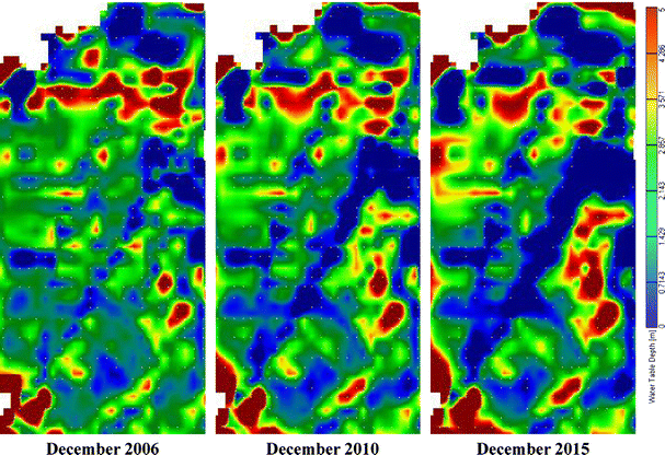
When the delivery is 9.0 × 10⁸ m3/a, compared the simulation groundwater levels with 2006a
-
(2)
When the quantity of delivery was 6.0 × 10⁸ m3/a (Fig. 9), the groundwater levels variation was similar with scenario (1) in the whole Basin. The groundwater levels would still drop in the southwestern part of Ejina Basin, the downtrend was insignificant difference with the scenario (1), the reason was that the groundwater levels depth of burial would get deeper and the hydraulic gradient of groundwater turns larger in the south, so that the groundwater would get less recharge by the rivers. But in Ejina Oasis, East, West Juyan Lake and Badain Jaran Desert, the groundwater levels would be uplift, the variation extent was less than the first case. So it could basically maintain the groundwater levels near Ejina Oasis, provide the required water for normal growth of vegetation. The groundwater levels would obviously decline in the southern part of the basin, which was to say the groundwater was lacking the enough recharge in the southern part of the basin, but the groundwater levels were quite sufficient with 2006a′ in the northern Ejina Oasis.
Fig. 9 
When the delivery is 6.0 × 10⁸ m3/a, compared the simulation groundwater levels with 2006a
-
(3)
When the delivery was 3.0 × 10⁸ m3/a, the groundwater levels would have been generally declined through the region, the exploitable quantity of groundwater could not have been satisfied with the current demand. In the southern basin, the groundwater levels would seriously decline, second in the western part of Ejina Basin and near the rivers. The groundwater levels would generally drop except the irrigation areas in Ejina Oasis (Fig. 10). The declining of the groundwater levels would seriously influence the normal vegetation growth. Furthermore, it would cause the deterioration of the ecological environment.
Fig. 10 
When the delivery is 3.0 × 10⁸ m3/a, compared the simulation groundwater levels with 2006a


Conclusions
The study simulated the groundwater level temporal and spatial variations in Ejina Basin including the region lacking the groundwater observation wells. It makes up the inadequacy of the groundwater observations, and provides an important basement for the evolution of the ecological environment and restoration in Ejina Basin. The results of calibration showed that the predicted results matched well with the observed data. The model could be used to predict the groundwater levels variation under different hypothesis conditions in Ejina basin, which would provide the effective reference to the rational use and management of the groundwater.
The Ejina Basin is a very complicated aquifer system. Although some basic hydrogeological survey work had been carried in the 1960s to 1980s, as the changes of groundwater movement environment in Ejina Basin it was more difficult to simulate the groundwater levels changes in the future. At the same time, owing to the groundwater levels observation wells are insufficiency in the Ejina Basin, especially the long sequences of observation data, the parameter estimation existed a certain degree of error during the course of groundwater simulation. So more effective technical methods, means are needed for making up for these questions.
References
Anderson MP, Woessner WW (1992) Applied groundwater modeling: simulation of flow and advective transport. Academic Press Inc, San Diego, CA
Brodie RS (1998) Integrating GIS and RDBMS technologies during construction of a regional groundwater model. Environ Modell Softw 14:119–128. doi:10.1016/S1364-8152(98)00063-2
Coppola EA Jr et al (2005) A neural network model for predicting aquifer water level elevations. Ground Water 43:231–241. doi:10.1111/j.1745-6584.2005.0003.x
De Hamer W, Love D, Owen R, Booij MJ, Hoekstra AY (2008) Potential water supply of a small reservoir and alluvial aquifer system in southern Zimbabwe. Phys Chem Earth Parts A/B/C 33:633–639. doi:10.1016/j.pce.2008.06.056
Deng JM, Wang GX (2005) Ecological measures of sustainable development of agriculture in the arid areas of China. Sci Tech Rev 23:51–55
Facchi A, Ortuani B, Maggi D, Gandolfi C (2004) Coupled SVAT-groundwater model for water resources simulation in irrigated alluvial plains. Environ Modell Softw 19:1053–1063. doi:10.1016/j.envsoft.2003.11.008
Gedeon M et al (2007) Regional groundwater model of north-east Belgium. J Hydrol 335:133–139. doi:10.1016/j.jhydrol.2006.11.006
Jin XM, Hu GC, Li WM (2008) Hysteresis effect of runoff of the Heihe River on vegetation cover in the Ejina oasis in Northwestern China. Earth Sci Front 15: 198–203 (in Chinese) doi:10.1016/S1872-5791(08)60054-8
McDonald MG, Harbaugh AW (1988) A modular three-dimensional finite-difference ground-water flow model. U.S. Geological Survey Techniques of Water-Resources Investigations, Book 6 Chap A1, p 586
Perkins SP, Sophocleous M (1999) Development of a comprehensive watershed model applied to study stream yield under drought conditions. Ground Water 37:418–426. doi:10.1111/j.1745-6584.1999.tb01121.x
Qin JH, Lv B, Zhao YC (2004) Solonchak resources and soil building effect of salt-tolerant forage grasses. Soils 36:71–75 (in Chinese)
Rodriguez LB, Cello PA, Vionnet CA, Goodrich D (2008) Fully conservative coupling of HEC-RAS with MODFLOW to simulate stream-aquifer interactions in a drainage basin. J Hydrol 353:129–142
Sophocleous M, Perkins SP (2000) Methodology and application of combined watershed and ground-water models in Kansas. J Hydrol 236:185–201. doi:10.1016/S0022-1694(00)00293-6
Su YH, Feng Q, Zhu GF (2007) Identification and evolution of groundwater chemistry in the Ejin Sub-basin of the Heihe River, Northwest China. Pedosphere 17:331–342. doi:10.1016/S1002-0160(07)60040-X
Wu XM (2000) Groundwater exploitation and ecological environment protection in Ejina basin of Heihe River watershed, northwestern China. Wuhan, China Univ Geosci 21:121–125 (in Chinese)
York JP, Filby S (2000) A Holocene hydrologic model of the Crow Wing Watershed, Minnesota. J Geochem Explor 69–70:419–422. doi:10.1016/S0375-6742(00)00135-7
Acknowledgments
Financial support for this study was given from National Natural Science Funds for Distinguished Young Scholar (1140725001)/National Natural Science Foundation of China (40671010). Cosponsored Fellowship is gratefully acknowledged. The authors also appreciate the anonymous referees for their comments towards improvement of this manuscript.
Author information
Authors and Affiliations
Corresponding author
Rights and permissions
About this article
Cite this article
Xi, H., Feng, Q., Liu, W. et al. The research of groundwater flow model in Ejina Basin, Northwestern China. Environ Earth Sci 60, 953–963 (2010). https://doi.org/10.1007/s12665-009-0231-1
Received:
Accepted:
Published:
Issue Date:
DOI: https://doi.org/10.1007/s12665-009-0231-1