Abstract
In the Himalayas, food security of communities primarily depends on local agricultural productivity and food purchasing power. Subsistence agriculture, which is forest based, constitutes the main source of rural food and livelihoods. However, due to constraints of terrain and climate, agricultural productivity is low, resulting in large food deficits and leading to a considerable proportion of the adult male population migrating from the region in search of employment and livelihoods. Remittances from the migrants and local off-farm employment contribute to community purchasing power which may be used to buy food from the open market and government controlled Public Distribution System (PDS). Depletion of natural resources, changing climatic conditions, the recent economic recession and sharply fluctuating food prices have not only decreased local food production but also reduced employment opportunities locally as well as outside the area, rendering the entire region highly vulnerable to food insecurity. This study, which was carried out in the Upper Kosi Catchment in Kumaon Himalaya, India, revealed that not only has annual agricultural productivity declined by nearly 125 Kg per ha (25 %) during the last 30 years, causing an annual food deficit of 1883 tonnes (65 %) and massive decline in per capita food production, but that local off-farm employment opportunities in different traditional rural sectors has also declined. Furthermore, the recent economic recession and the resultant job losses for migrants has decreased incoming remittances by 20 %–25 %, causing the loss of local purchasing power and posing a serious threat to food security. Those particularly affected are marginal and smallholder farmers, and landless households, which mainly include socially backward communities and families with very low incomes. It is therefore imperative that a community oriented framework for the management of land, water and forest resources is planned and implemented in this region, together with the generation of viable means of off-farm employment at the local level
Introduction
The Food and Agricultural Organization (1996) defined food security as “a situation that exists when all people, at all times, have physical, social and economic access to sufficient, safe and nutritious food that meets their dietary needs and food preferences for an active and healthy life”. In developing and underdeveloped countries the food security situation has been continuously deteriorating for the last several years, mainly because of increasing population and the resultant increasing gap between supply and demand for food. Additional factors are an increasing demand for food in emerging economies, changing food habits, bio-fuel production, and encroachment on productive agricultural land by rapid urbanization and industrialization. Furthermore, agricultural production is facing serious challenges from the depletion of natural resources with the consequent loss of ecosystem services, and the potential impact of climate change (Roberts 2009; World Commission on Environment and Development 1987).
The economic recession which started in 2008 and the resultant losses of jobs and income have increased hunger and malnutrition in many developing and underdeveloped countries. This has been exacerbated by restrictions on exports of staple food commodities, such as wheat and rice by some of the more prominent producing and exporting countries (FAO 2008a). Besides, large fluctuations in food prices, which went down with the economic recession and increased in the first quarter of 2010 and then again decreased at the beginning of the second half of the year, have also adversely affected food security in developing and poor countries (FAO 2008a; Fullbrook 2010; Bakhshoodeh 2010). It has been estimated that more than 1 billion people in the world do not have access to sufficient dietary energy, and nearly 2 billion people are suffering from micronutrient deficiencies (Barrett 2010). Further, recent estimates of agricultural productivity predict an average decline in global food production of between 3 % and 16 % by 2080 due to global warming (Cline 2008). Developing and underdeveloped countries in the south, owing to their large populations and subsistence agricultural economies, are likely to face more severe food crises due to climate change than the developed countries of the north (Cline 2008; Aase et al. 2009). This has led to renewed concerns about food insecurity and calls for further investigation of the vulnerability of mountain communities with respect to food security (Huddleston et al. 2003).
Mountainous regions, which encompass nearly 24 % of the total land surface of the earth and are home to approximately 12 % of the world’s population, are highly critical from the view point of food security. This is because of their subsistence economies, the constraints of terrain and climate, physical isolation, low productivity, vulnerability to natural risks, poor infrastructure, limited access to markets and high cost of food production. Those living in these areas and who are vulnerable to food insecurity number nearly 245 million according to some estimates (Huddleston et al. 2003; FAO 2008b).
In the Himalayas, the nature of the terrain imposes severe limitations on the scale of productive activities as well as on the efficiency of infrastructural facilities. As a result, biomass based subsistence agriculture constitutes the main source of rural food supply and livelihoods for more than 70 % of the population, despite the limited availability of arable land (Tiwari 1995, 2008). Owing to these constraints, a large proportion of the adult male population out-migrates in search of employment and livelihoods. The remittances they send home constitute the principal source of cash income and food purchasing power of the majority of the rural population in the Himalayas (Tiwari 1995), but during the recent past, the natural resource base has been steadily depleted, leading to significant disruption of ecosystem services, particularly water, biomass and soil-nutrients with a consequent decline in food productivity (Tiwari 2000).
Moreover, global climate changes have already stressed the Himalayan agro-ecosystem through higher mean annual temperatures, altered precipitation patterns and more frequent and extreme weather events. These have adversely affected food and livelihood security in the region (ICIMOD 2007). The Himalayas have shown a consistent trend in overall warming during the past 100 years (Yao et al. 2004; Du et al. 2004). Consequently, the Himalayan glaciers are retreating fast (Dyurgerov and Meier 2005; Fujita et al. 2001), and changing monsoon patterns are reducing the number of rainy days and amount of rainfall (IPCC 2007a, b). These changing climatic conditions are expected to cause a 30 % decrease in agricultural productivity in India, including the Himalayas (Cline 2008; IPCC 2007c; UNDP 2006). A number of studies describing the mountain environment and livelihoods in terms of ‘fragility’ and ‘crisis’ (FAO 1997, 2003; Adhikari and Bohle 1999; Blaikie et al. 2001; Jodha 2005), indicate that the spectacular environmental and climatic changes that are currently taking place in the Himalayan ecosystem are likely to have distressing effects on many factors in the entire region: these include ecosystems services, traditional farming systems, livelihoods, food security and community sustainability (Aase et al. 2009).
The main objective of this paper is to analyze the status of traditional agricultural systems and to identify the key factors of food insecurity in the Himalayas by analyzing the pattern of food production, procurement and consumption and by interpreting their environmental and socio-economic drivers. These are illustrated with a case study of the Upper Kosi Catchment in Kumaon Himalaya, India.
Materials and methods
Description of the study area
The Upper Kosi Catchment in Kumaon, Himalaya, which encompasses a land surface area of 107.94 km2 (10794 ha) between 1,425 and 2,650 m above mean sea level, is in the Lesser Himalayan ranges of the Almora district. This district, together with 12 others, constitutes the newly established Himalayan state of Uttarakhand (Fig. 1). The slope of the Catchment varies from 5° to >67° and the total population of the region is 16,080 persons. They live in 62 villages, just over half of which are situated within 5 km of a road. The watershed is one of the most densely populated and agriculturally active areas of Kumaon with an average population of 149 persons/km2, rising to 469 persons/km2 for villages (Figs. 2, 3, 4 and 5). The major land categories are forests, cultivated land and barren land. Subsistence agriculture, with animal husbandry as its natural ally, constitutes the main sources of livelihoods. Over 75 % of the population depends on subsistence agriculture although the availability of arable land is severely limited. More than 90 % of operational land holdings are of less than one hectare and the availability of cultivated land is only 0.17 ha per capita, resulting in low productivity of food at the household level as well as low economic viability of agriculture in the region. As in other parts of the Himalayas, owing to the constraints of the subsistence agricultural economy, a large proportion of the adult male population migrates out of the region in search of employment and livelihoods. Despite this increasing trend, the community has shown rapid but unsustainable growth, putting increased stress on land, forests, water and other critical natural resources in the region. Cultivation, grazing and deforestation have been extended over large areas leading to ecological instability and food insecurity in the entire river basin (Figs. 4, 5 and 6).

Location map of the study area. A colour version of this figure is available in the online edition.

Idealized transect showing land and resource use by altitude in Uttarakhand. The best arable land in the Himalayan Mountains is on the valley floors. With population increase, cultivated land has been extended to higher altitudes causing depletion of forests and water resources and intensification of use of marginal land. When this land is no longer productive it is abandoned

Food crop cultivation on mid-slopes. A colour version of this figure is available in the online edition.

Intensively cultivated steep slopes at higher elevations. A colour version of this figure is available in the online edition.

Photograph demonstrating crop rotation with seasonal fallow land and food crop cultivation on mid-slopes. A colour version of this figure is available in the online edition.

Idealized transect showing land and resource use by altitude in Uttarakhand. The best arable land in the Himalayan Mountains is on the valley floors. With population increase, cultivated land has been extended to higher altitudes causing depletion of forests and water resources and intensification of use of marginal land. When this land is no longer productive it is abandoned. A colour version of this figure is available in the online edition.
Analytical methods
-
The information and data required for the study were generated and collected from both primary and secondary sources (Fig. 7). Land use and forest and agricultural resource maps were prepared using high resolution satellite data from the 2010 Survey of India Topographical Maps at a scale of 1:50,000. Digital interpretation techniques supported by intensive ground validation were used and the Normalized Difference Vegetation Index (NDVI) was employed in order to enhance the interpretation of remote sensing data. This was followed by the digital classification of land cover/land use through on-screen visual recording and rectification. All major land use types were identified, characterized and mapped.
Fig. 7 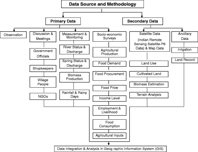
Data sources and methodology.
-
In order to analyze changes in agricultural resource use, satellite data of 1980 and 2010 were compared. They were converted into spatial layers and compared with each other using the Geographic Information System (GIS), which ensures the maximum level of precision possible. An accurate map of the change in land use in the study area was generated and was later used for monitoring changes in agricultural land use and in developing estimates of fuel wood and fodder production.
-
Rainfall patterns and hydrological parameters, such as water discharge in springs and streams and their status were collected from meteorological stations located in the region, and by the authors. Villages in which the availability of water for domestic requirements was less than 40 l per capita per day (lpcd) were categorized as water scarcity settlements (Government of India 2005).
-
Detailed information was collected between the years 1980 and 2010 through comprehensive village and household surveys using exclusively designed schedules and questionnaires about the following:
-
Biomass supply to cultivated land. This is manure from livestock fed from forest products.
-
Irrigation potential
-
Size of landholding
-
Food productivity and demand
-
Food consumption patterns
-
Food purchasing power (i.e. income from selling of agricultural and animal products, remittances sent by migrated family members and income from local employment)
-
Procurement of food
-
Food prices
-
Rural livelihood opportunities
-

The primary survey was carried out in all of the 62 villages of the upper Kosi Catchment which varied in altitude, covering 25 % of the households in each Village. The selection of households was done on the basis of the size of their land holdings (land holdings of less than 1 ha, 1–2 ha and above 2 ha) and income level of families (families Below Poverty Line and Above Poverty Line).Footnote 1 The composition of the samples was proportionate to the numbers of families with the three sizes of land holdings and income levels.
Elderly members of families were included in the survey in order to analyze the changes that had occurred between 1980 and 2010 with respect to certain important factors, such as supply of manure, food production and consumption, family income, irrigated land and rural livelihood opportunities.
-
The food deficit situations were determined by estimating demand for food and its local production at village level.
-
As wheat, rice and pulses constitute 90 % of the diet of people living in the region, they were analyzed with regard to production, demand, availability and consumption. The food deficit was determined as the difference between production and demand, using the dietary norms recommended by the National Institute of Nutrition (NIN) (2010) as a measure of the latter.
-
Food security at the household level was determined as availability from agricultural production and access, using purchasing power as a proxy. Households which did not reach NIN norms were categorized as food insecure. The food purchasing power of households was estimated from (i) the income of the family from various sources, such as the selling of agricultural and animal products e.g. vegetables and milk; local off-farm employment by government and private sectors in such work as forestry, agriculture and construction; remittances sent by migrated members of family; and (ii) the amount that a family could afford for buying food from market.
-
Information about price increases of wheat, rice and pulses during 2008–2010 was obtained from a detailed survey of 5 % of local grocery shops as well as through household surveys.
-
The information and data generated and collected from various sources was transformed into spatial and non-spatial databases using GIS.
Results
Nearly 75 % of the 16,080 persons making up the population of the Upper Kosi Catchment are dependent on forest-based subsistence agriculture. Of the total area (107.94 km2) 7.81 % had changed usage between 1980 and 2010. Cultivated land had increased by 14.33 % and the forest area had decreased by 4.36 %.The increase in cultivated land came from forests and barren lands (0.20 km2), particularly in up-slopes (Fig. 6).
The number of annual rainy days had declined from an average of 72 days to just over 58 days with a few exceptions. Consequently, the amount of annual rainfall had decreased from an average of 132 cm to approximately 102 cm between 1990 and 2010 (Fig. 8). As a result, the water discharge in streams and springs has diminished drastically, which is clearly indicated by the observed trends of water discharge of the master stream of the Kosi catchment area (Fig. 9). The river showed a continuously declining water discharge between 2000 and 2007. However, the water discharge in the river increased in 2008, remained almost stable in 2009, and increased substantially in the year 2010. Furthermore, a stream-length of approximately 7.36 Km comprising mainly first order tributary streams of the Kosi River had completely dried during the last 30 years (Table 1). Seventy-three (37 %) of natural springs had gone dry and 28 (14 %) had become seasonal, primarily due to the decreasing trend in rainfall and declining groundwater recharge in the catchment (Table 1). A total of 38 villages are water scarce and there has been a decline in irrigated area of 78 ha (16 %). The decrease in irrigated area ranged from 3 ha to 40 ha (14 % and 21 % of total irrigated land) in different villages (Table 2).

Rainy days and average annual rainfall in the study region 1990–2010. A colour version of this figure is available in the online edition.

Average annual discharge of the Kosi River 2001–2010. A colour version of this figure is available in the online edition.
The intensification of land use on fragile mountain slopes and resultant depletion of forest resources has adversely affected the local agricultural system through reduced supply of biomass manure (manure from livestock fed from forest fodder). The interpretation of primary data collected through household surveys revealed that the average supply of manure to agricultural land had declined from 15 tonnes/ha/year in 1980 to 9 tonnes/ha/year in 2010 (Table 3). As a result, the productivity of agriculture had declined by nearly 125 Kg/ha (25 %) between 1980 and 2010, and per capita food productivity had decreased from 190 Kg to 120 Kg per annum between 1971 and 2009 (Fig. 10 and Table 4). As a result, in 2010 the different villages in the catchment faced a food deficit ranging between 174 tonnes/year (76 %) and 881 tonnes/year (79 %) with an overall food shortage of 1883 tonnes/ha (65 %) (Table 5).

Food production and annual per capita food availability from local production in the Study Region 1971–2009. A colour version of this figure is available in the online edition.
Between 1980 and 2010, there were losses of 1802 opportunities for traditional livelihoods in the area. Of these 531 were in the forest sector, 370 in agriculture and 255 in the collection of medicinal plants. A further loss of 371 in livestock production and 275 in traditional handicraft and agricultural tool making activities also occurred (Table 6).
The purchasing power of the villagers has been aggravated by two factors: the decline in remittances of 20–25 % from the out-migrated population and the price hike of food commodities such as wheat flour, rice and pulses between January 2008 and January 2010. The latter has reduced the purchasing power of local people between 30 and 35 % and consequently exacerbated food insecurity in the region (Fig. 11). As a result, the poor and socially marginalized communities have either stopped or drastically reduced their purchases of expensive food commodities, such as pulses from the market (Fig. 12). However, people are consuming locally grown pulses but these are low in productivity. This has had an adverse impact on the nutrition and health of a large proportion of the rural population in the area. The communities most vulnerable to food insecurity in the region include mainly marginal and small holder farmers with land holdings of less than 1 ha (45 %), landless households, mainly lower caste communities (5 %), households with marginal income from other sources (41 %), households with no income from other sources (9 %), and households with most of the cultivated land rain-fed and with scarce family labour (Table 7).

Increase in prices of important food commodities in the study region 2008–2010. A colour version of this figure is available in the online edition.

Decrease in consumptions of important food commodities in the study region 2008–2010. A colour version of this figure is available in the online edition.
Discussion
As in other parts of the Himalayas, owing to constraints of terrain and climate, forest based subsistence agriculture constitutes the main source of rural food and livelihoods in the region (Maithani 1986; Tiwari and Joshi 2011). However, crop farming is not economically viable in most areas of the region due to several geo-environmental constraints and resultant poor agricultural productivity. The availability of arable land is low, size of land holdings is very small and consequently the intensity of cropping is as high as 150 %. In order to preserve soil fertility and productivity of land under sustained cropping in such an agro-ecosystem, there must be a net transfer of energy from the forests to arable land (Whittaker 1989). This net flow of energy is mediated through livestock and is usually in the form of fodder of stall-fed cattle whose manure is applied to the cultivated land (Figs. 13 and 14). Forest, livestock and arable land are the three basic components of the Himalayan agro-ecosystem, in which forests are pivotal to the maintenance of crop production levels. On average, one unit of agronomic production in the region involves nine units of energy from the surrounding forest ecosystem (Singh et al. 1984).

Women carrying compost manure to agricultural fields in group. A colour version of this figure is available in the online edition.

Traditional ploughing of cultivated land – preparation for new crop. A colour version of this figure is available in the online edition.
Micro-irrigation facilities were developed in the Upper Kosi Catchment, starting in 1971, which increased food productivity in some valleys. Increased road connectivity facilitated the use of chemical fertilizers and production of vegetables and milk for sale in nearby and far-off markets. The establishment of the Indo-German Agricultural Development Authority (IGADA) in the district of Almora (the study area is part of the Almora district), which functioned from 1966 to 1978, and improvement and development of agricultural extension services promoted the production of food crops, vegetables and milk in the region. However, during this period, the region registered a population increase of 83 % (2,571 people) despite increasing out-migration. As a result, both the availability of cultivated land per capita and yield declined. In turn, this caused a decrease in food productivity despite the expansion of cultivation on marginal and sub-marginal areas. Also once the land became unproductive it was abandoned (Pande 1998).
During recent years, a variety of changes have emerged in traditional agricultural resource patterns, mainly in response to population growth and resultant increased demand for arable land, grazing areas, fuel wood and fodder in the region (Tiwari and Joshi 2011). Consequently, there have been rapid increases in agriculture in marginal areas, deforestation and reduced supply of manure for cultivated land. Moreover, the variability of rainfall observed both in terms of declining amount and numbers of rainy days have adversely affected food productivity as 88 % of the agricultural land in region is rainfed. The rapidly changing patterns of land use and increasing variability of rainfall have disrupted the hydrological regime of the entire catchment, and this has had unprecedented adverse impacts on the water resources of the region, as in other parts of the Himalayas (Ives 1985, 1989). The water resources of the catchment area are diminishing and depleting fast mainly due to reduced ground water recharge (Valdiya and Bartarya 1991; Tiwari 1995, 2000, Bisht and Tiwari 1996, Tiwari and Joshi 2005). Studies carried out in different parts of the Himalayas have shown that the amount of surface run-off from cultivated and barren lands is much higher than that from other categories of land use, particularly forests and areas under horticulture (Tiwari 1995, 2000; Rawat 2009).
These hydrological imbalances are clearly discernible in (i) long-term decreasing trend of stream discharge, (ii) diminishing discharge and drying of springs, and (iii) biotic impact of surface run-off flow systems and channel network capacities (Rawat 2009, Valdiya and Bartarya 1991, Tiwari and Joshi 2005). In turn, these have adversely affected irrigation potential, which has considerably decreased during the last three decades, mainly owing to reduced ground water recharge and drying of springs and streams. Irrigation potential has been analyzed in terms of decline of area under irrigation owing to non-availability of adequate water in the irrigation system. Besides hydrological disruptions, population growth and resultant increased demand of water, both for domestic and agricultural purposes, have also stressed the water resources in the region. The loss of basic ecosystem services, particularly water and biomass has had unprecedented adverse impacts on the agricultural productivity in the entire region. The region also suffered a massive loss of agro-biodiversity in terms of reduction of a large variety of staple food-crops, particularly paddy, wheat and pulses mainly due to changes in food habits and socio-economic and environmental changes (Palni et al. 1998). The observed decrease in fodder supplies has greatly harmed livestock health and productivity, which has further worsened the nutrition of the rural population, particularly children who were already malnourished.
As in other parts of the Himalayas, food security in the region mainly depends on local agricultural productivity, family income, availability of employment to individuals who have migrated outside the region, food purchasing power of the people and infrastructural facilities for the transportation, storage and distribution of food. As mentioned earlier, the land use intensifications and the resultant loss of ecosystem services and changing pattern of rainfall have caused a decline of 125 Kg per hectare (approximately 25 % per hectare) in the food productivity between 1980 and 2010. In 2010 the region faced an overall food deficit of 1883 tonnes (nearly 65 %) undermining food and livelihood security, economy and quality of life of the rural population (Table 5). The growing food deficit has increased the dependency of the local population on the import of food from other parts of the country. In view of this, adequate and appropriate infrastructure facilities, such as all weather road connectivity, storage of food, particularly during the monsoon and snowy winter months, and an easily accessible network of food distribution centres is of critical importance for ensuring food availability and security in the region (Sati 2008). Unfortunately, the infrastructural facilities required for the proper and efficient distribution of food are lacking, as in other parts of Himalayan Mountains. Recently, there were reports in Indian print and electronic media that thousands of tonnes of food grains had decayed in government warehouses in various parts of the country mainly owing to improper storage facilities. This was later acknowledged by the Indian Government. The inadequate and inefficient infrastructural facilities in the Himalayan mountains are posing serious threats to food security, particularly in settlements located in remote areas and those at high elevation (Sati 2008).
Foodgrains are made available to the local people through (i) the Public Distribution System (PDS) a government controlled system, and (ii) the open market. Essential food commodities, such as wheat, wheat-flour, rice and sugar are made available to poor families (i.e., families whose income is less than approximately US$ 1 per day) through the PDS. This involves fair price shops and prescribed quantities at reasonable prices. Families whose income is more than US$ 1 per day can buy food commodities from other shops as per their requirement at open market rates. As the majority of families have very low income levels, PDS has played a significant role in ensuring food security in the region. However, during recent years, the PDS has almost collapsed in the region, as in many other parts of the country, due to failure of government control over procurement and distribution of food commodities, and again, this is posing a severe challenge to food security in the region (Basu 2011, Drèze 2010).
Further, the procurement of food either from the PDS or from the open market depends on the level of cash income and purchasing power of the people. A huge proportion of the rural population, particularly landless, marginalized and poor people largely depends for their income on agricultural labour, village based processing of agricultural and livestock products, making agricultural tools, traditional handcraft items and collection of medicinal plants - a situation similar to many less developed regions of the world (Hauenstein et al. 2010). All these activities are completely based on the availability of local resources, mainly agriculture, livestock, forests and biodiversity. Traditionally they provide livelihood and employment to large sections of rural society, and thus contribute towards community cash income and purchasing power. However, due to depletion of forests, and decline in agricultural and livestock productivity, the availability of livelihoods in these traditional rural sectors has declined considerably during the past three decades.
In addition, the short term shocks, particularly the recent economic recession, have also adversely affected the food security situation in the region. Remittances sent by those who have migrated from the area constitutes the principal source of income, and therefore food purchasing power of rural communities, but this has been jeopardized by the economic recession owing to the loss of jobs and decline in employment opportunities. This is likely to have long-term impacts on food security of the region in terms of quantity, quality and nutritional value of the food. In turn, this will adversely affect particularly the poor and socially marginalized people who constitute nearly 75 % of the population. It is therefore imperative that an inclusive framework is established for the sustainable development of land, water and forest resources and the generation of off-farm employment at the local level for the entire region.
Conclusion
The outcomes of this study clearly indicate that depletion of natural resources and changing precipitation pattern have stressed agricultural and food systems and undermined livelihood opportunities in traditional rural sectors in the Himalayas. The region, being ecologically sensitive, economically underdeveloped and densely populated is highly vulnerable to these changes. These have caused substantial decreases in availability of critical natural resources, such as arable land, water and forests for food production, and consequently have increased the proportion of food and livelihood insecure people. It is therefore imperative to evolve a comprehensive policy for land use and an integrated framework for sustainable development of natural resources. It is particularly essential to analyse changes in precipitation patterns, interpret consequent hydrological responses, and identify potential adaptive and participatory water management strategies. These would involve the participation of rural communities, government agencies, private sector enterprises, non-government organizations and civil society institutions. Furthermore, it would also be necessary to design an action plan for comprehensive and sustainable development of agricultural resources and creation of off-farm employment opportunities to increase the food purchasing power of rural communities, particularly poor and marginalized people. Such a community plan, which could be integrated with the existing Mahatma Gandhi National Rural Employment Guarantee Act (MGNREGA), would be helpful in improving the food security situation in the region.
Notes
Families whose income is less than 1US Dollar per day have been categorized as Families Below Poverty Line (BPL) and those whose income is more than 1US Dollar per day have been categorized as Families Above Poverty Line (APL).
References
Aase, T. H., Chaudhary, R. P., & Vetaas, O. R. (2009). Farming flexibility and food security under climatic uncertainty: Manang, Nepal Himalaya, AREA. Royal Geographical Society (with the Institute of British Geographers), 42(2), 228–238. doi:10.1111/j.1475-4762.2009.00911.x.
Adhikari, J., & Bohle, H. G. (1999). Food crisis in Nepal: How mountain farmers cope? New Delhi: Adroit Publications.
Bakhshoodeh, M. (2010). Impacts of world prices transmission to domestic rice markets in rural Iran. Food Policy, 35, 12–19. doi:10.1016/j.foodpol.2009.06.006.
Barrett, C. B. (2010). Measuring food insecurity. Science, 327(5967), 825–828. http://www.sciencemag.org/cgi/content/abstract/327/5967/825.
Basu, K. (2011). India’s food grain policy: an economic theory perspective. Economic and Political Weekly, 46(5), 37–46.
Bisht, B. S., & Tiwari, P. C. (1996). Land use planning for sustainable resource development in Kumaon Lesser Himalaya: a study of Gomti Watershed. International Journal of Sustainable Development and World Ecology, 3, 23–34.
Blaikie, P. M., Cameron, J., & Seddon, J. D. (2001). Nepal in crisis. Growth and stagnation at the periphery. Delhi: Adroit Publishers.
Cline, W. R. (2008). Global warming and agriculture. Finance and Development, 45(1), 23–27.
Drèze, J. (2010). The task of making the PDS work, The Hindu, 8 July 2010
Du, M. Y., Kawashima, S., Yonemura, S., Zhang, X. Z., & Chen, S. B. (2004). Mutual influence between human activities and climate change in the Tibetan Plateau during recent years. Global and Planetary Change, 41, 241–249.
Dyurgerov, M. D., & Meier, M. F. (2005). Glaciers and changing earth system: A 2004 Snapshot, Occasional paper 58, Institute of Arctic and Alpine Research, University of Colorado, Boulder, Colorado.
Food and Agriculture Organization. (1996). Declaration on world food security. Rome: World Food Summit, FAO.
Food and Agricultural Organization. (1997). Managing fragile ecosystems—sustainable mountain development in Rio Earth Summit Review chapter 13. New York: UN/FAO.
Food and Agricultural Organization (2003). Agriculture, food and water, chapter 2, FAO, Rome, http://www.fao.org/DOCREP/006/Y4683E/y4683e06.htm.
Food and Agricultural Organization (2008a). Soaring food prices: Facts, perspectives, impacts and actions required, high-level Conference on World Food Security: The Challenges of Climate Change and Bio Energy, Hlc/08/Inf/1, Rome, 3–5 June 2008.
Food and Agricultural Organization (2008b). Food security in mountains – high time for action. Brochure of the International Mountain Day. 2008. http://www.mountaineering.ie/documentbank/uploads/IMD08%20brochure.pdf.
Fujita, K., Kadota, T., Rana, B., Shrestha, R. B., & Ageta, Y. (2001). Shrinkage of Glacier AX010 in Shorong Region, Nepal Himalayas, in the 1990s. Bulletin of Glaciological Research, 18, 51–54.
Fullbrook, D. (2010). Food as security. Food Security, 2, 5–20. doi:10.1007/s12571-009-0050-y.
Government of India (2005). Norms for providing potable drinking water in rural areas, Report of Rajiv Gandhi National Drinking Water Mission, Chapter 1, New Delhi.
Hauenstein, S., Hadley, S. S., & Cichon, B. (2010). Crisis behind closed doors: global food crisis and local hunger. Journal of Agrarian Change, 10(1), 107–118. doi:10.1111/j.1471-0366.2009.00252.x.
Huddleston, B., Ataman, E., & d’Ostlanl, L. F. (2003). Towards a GIS-based analysis of mountain environments and populations. Rome: Food and Agricultural Organization.
ICIMOD (2007). Melting Himalayas: Regional challenges and local impacts of climate change on mountain ecosystems and livelihoods, Technical Paper, 11–24.
IPCC (2007a). Climate Change 2007: The physical science basis. Contribution of Working Group I to the Fourth Assessment Report of the IPCC.—http://www.ipcc.ch/ipccreports/ar4-wg1.htm.
IPCC (2007b). Climate change 2007: Impacts, adaption and vulnerability. Contribution of Working Group II to the Fourth Assessment Report of the IPCC.—http://www.ipcc.ch/ipccreports/ar4-wg2.htm.
IPCC (2007c). Climate change 2007: Mitigation of climate change. Contribution of Working Group III to the Fourth Assessment Report of the IPCC.—http://www.ipcc.ch/ipccreports/ar4-wg3.htm.
Ives, J. D. (1985). Himalayan environmental regeneration: An overview what are the problems and how can they be tackled. In J. S. Singh (Ed.), Environmental regeneration in Himalaya (pp. 1–11). Nainital: Gyanodaya Prakashan.
Ives, J. D. (1989). Deforestation in the Himalaya: the cause of increased flooding in Bangladesh and Northern India. Land Use Policy, 6, 187–193.
Jodha, N. S. (2005). Economic globalization and its repercussions for fragile mountains and communities in the Himalayas. In U. M. Huber, H. K. M. Bugmann, & M. A. Reasoner (Eds.), Global change and mountain regions (pp. 583–91). the Hague: Springer.
Maithani, B. P. (1986). Towards sustainable hill area development, Himalaya: man. Nature and Culture, 16(2), 4–7.
National Institute of Nutrition. (2010). Dietary guidelines for Indians: A manual. India: Hyderabad.
Palni, L. M. S., Maikhuri, R. K., & Rao, K. S. (1998). Conservation of the Himalayan agroecosystems: issues and priorities. In: Eco-regional Cooperation for Biodiversity Conservation in the Himalaya. UNDP, New York. pp 253–290.
Pande, D. C. (1998). New farm technology and hill peasantry in India. In P. C. Pande et al. (Eds.), The Himalayan environment: Issues and challenges (pp. 101–111). New Delhi: Daya Publishing House.
Rawat, J. S. (2009). Saving Himalayan Rivers: Developing Spring Sanctuaries in Headwater Regions. In B. L. Shah (Ed.), Natural resource conservation in Uttarakhand (pp. 41–69). Haldwani: Ankit Prakshan.
Roberts, P. (2009). The end of food. New York: Houghton Mifflin Harcourt.
Sati, V. P. (2008). Natural resource management and food security in Alakhnanda Basin of Garhwal Himalaya, Environmental Information System (ENVIS) Bulletin, G. B. Pant Institute of Himalayan Environment and Development, Alomra, India, 12(2), 1–11.
Singh, J. S., Pandey, U., & Tiwari, A. K. (1984). Man and forests: a central Himalayan case study. Ambio, 13, 80–87.
Tiwari, P. C. (1995). Natural Resources and Sustainable Development in Himalaya. Almora: Shree Almora Book Depot.
Tiwari, P. C. (2000). Land use changes in Himalaya and their impact on the plains ecosystem. Land Use Policy (U.K.), 17(2000), 101–111.
Tiwari, P. C. (2008). Land use changes in Himalaya and their impacts on environment, society and economy: a study of the Lake Region in Kumaon Himalaya, India. Advances in atmospheric sciences. An International Journal of Chinese Academy of Sciences, Beijing, 25(6), 1029–1042.
Tiwari, P. C., & Joshi, B. (2005). Environmental changes and status of water resources in Kumaon Himalaya. In J. Libor et al. (Eds.), Sustainable management of headwater resources: Research from Africa and Asia (pp. 109–12). Tokyo: United Nations University.
Tiwari, P. C., & Joshi, B. (2011). Urban growth and food security in Himalaya, International Working Paper Series, Urbanization and Global Environmental Change (UGEC) View point. International Human Dimension Programme (IHDP), 1(5), 20–23.
UNDP. (2006). Human development report: Beyond scarcity: power, poverty and the global water crisis. New York: United Nations Development Programme.
Valdiya, K. S., & Bartarya, S. K. (1991). Hydrological studies of springs in the catchment of Gaula River, Kumaon Lesser Himalaya, India. Mountain Research and Development, 11, 17–25.
Whittaker, W. (1989). The ecology and economy of Himalayan agriculture and labour migration: A case study of Garhwal District. In D. C. Pandey & P. C. Tiwari (Eds.), Dimensions of development planning (pp. 509–550). New Delhi: Criterion.
World Commission on Environment and Development. (1987). Our common future. Oxford: Oxford University Press.
Yao, T. D., Wang, Y. Q., Liu, S. Y., Pu, J. C., & Shen, Y. P. (2004). Recent glacial retreat in high Asia in China and its impact on water resources in Northwest China. Science in China - Series D: Earth Sciences, 47(12), 1065–1075.
Acknowledgement
Part of the research was carried out within the research project ‘Natural Resources Information System for Wasteland Development in Kosi Headwater, Kumaon Himalaya’ supported by the Department of Sciences and Technology, Government of India, New Delhi and the outline of the paper was presented and discussed in the international workshop on ‘Key Drivers of Food Security in Mountains’ sponsored by Mountain Research Initiative (MRI), Bern, Switzerland. The authors are thankful to both agencies for their generous financial support.
Author information
Authors and Affiliations
Corresponding author
Rights and permissions
About this article
Cite this article
Tiwari, P.C., Joshi, B. Natural and socio-economic factors affecting food security in the Himalayas. Food Sec. 4, 195–207 (2012). https://doi.org/10.1007/s12571-012-0178-z
Received:
Accepted:
Published:
Issue Date:
DOI: https://doi.org/10.1007/s12571-012-0178-z