
Abstract
Karst aquifers have complex and original characteristics which make them very different from other aquifers: high heterogeneity created and organised by groundwater flow; large voids, high flow velocities up to several hundreds of m/h, high flow rate springs up to some tens of m3/s. Different conceptual models, known from the literature, attempt to take into account all these particularities. The study methods used in classical hydrogeology—bore hole, pumping test and distributed models—are generally invalid and unsuccessful in karst aquifers, because the results cannot be extended to the whole aquifer nor to some parts, as is done in non-karst aquifers. Presently, karst hydrogeologists use a specific investigation methodology (described here), which is comparable to that used in surface hydrology.
Important points remain unsolved. Some of them are related to fundamental aspects such as the void structure – only a conduit network, or a conduit network plus a porous matrix –, the functioning – threshold effects and non-linearities –, the modeling of the functioning – double or triple porosity, or viscous flow in conduits – and of karst genesis. Some other points deal with practical aspects, such as the assessment of aquifer storage capacity or vulnerability, or the prediction of the location of highly productive zones.
Resumen
Los acuíferos kársticos tienen características originales y complejas que los hacen muy diferentes de otros acuíferos: alta heterogeneidad creada y organizada por el flujo de agua subterránea, espacios grandes, velocidades altas de flujo de hasta varios cientos de m/h, manantiales con ritmo alto de flujo de hasta algunas decenas de m3/s. Diferentes modelos conceptuales que se conocen en la literatura tratan de tomar en cuenta todas estas particularidades. Los métodos de estudio usados en hidrogeología clásica- pozos, pruebas de bombeo y modelos distribuidos- son generalmente inválidos y no exitosos en acuíferos kársticos, debido a que los resultados no pueden extenderse a todo el acuífero ni a alguna de sus partes, como se hace en acuíferos no kársticos. Actualmente los hidrogeólogos kársticos usan una metodología de investigación específica, que se des cribe aquí, la cual es comparable con la que se utiliza en hidrología superficial. Puntos importantes permanecen sin resolverse. Algunos de ellos se relacionan con aspectos fundamentales tal como la estructura de espacios- solo una red de conductos, o una red de conductos más una matriz porosa-, el funcionamiento-efectos threshold y no-linealidades-, el modelizado del funcionamiento-porosidad doble o triple, o flujo viscoso en conductos- y génesis del karst. Algunos otros puntos se relacionan con aspectos prácticos, tal como la evaluación de la capacidad de almacenamiento del acuífero o la vulnerabilidad, o la predicción de la localización de zonas altamente productivas.
Résumé
Les aquifères karstiques présentent des caractères originaux complexes qui les distinguent profondément de tous les autres milieux aquifères : forte hétérogénéité créée et organisée par les écoulements souterrains eux-mêmes, vides de très grandes dimensions, vitesses d’écoulement pouvant atteindre quelques centaines de mètres par heure, sources à débit pouvant atteindre quelques dizaines de m3/s. Différents modèles conceptuels tentent de prendre en compte ces particularités. Les méthodes d’étude de l’hydrogéologie classique—forage, essai de pompage et modèles maillés – ne sont en général pas adaptés aux aquifères karstiques, parce que les résultats obtenus ne peuvent pas être étendus à l’aquifère tout entier, ou à certaines de ses parties, comme cela est fait pour les aquifères non karstiques. Actuellement les hydrogéologues du karst ont recours à une méthodologie d’étude spécifique décrite ici, comparable à celle utilisée en hydrologie de surface.
Des points importants restent à résoudre. Certains concernent des aspects fondamentaux, comme la structure des vides – réseau de conduits uniquement, ou bien réseau de conduits et matrice poreuse –, le fonctionnement – problèmes de seuil et plus généralement les non-linéarités –, la modélisation du fonctionnement – double porosité ou écoulement visqueux en conduits – et de la genèse du karst. D’autres points portent sur des aspects pratiques, comme l’évaluation de la capacité de stockage ou de la vulnérabilité de l’aquifère, et la prédiction des zones à haute productivité.
Introduction
In the middle of the 19th century, engineers of the agriculture administration of the Hungarian Austrian Empire studied the hydrology of the Karst region, presently a part of Slovenia, in order to develop farming in the countryside from Ljubljana to Trieste harbour, the only Austrian harbour on the Mediterranean Sea. They observed that the hydrology of the region looked unpredictable, surface streams disappearing in caves or holes, and that wide closed plains were frequently flooded during spring months, which was not favourable to farming.
Agriculture engineers assigned then a really important role by defining the main principles of the regional hydrology. Von Mojsisovics (1880) was probably the first of them to consider the Karst region as a particular physiographic, with a specific, mainly underground, hydrology. Following him, German-speaking authors applied the basic concepts defined in the Karst region to the whole carbonate mountains of Croatia and Herzegovina (see Cvijic 1893) and of Russia (Kruber 1900): their terminology concerns landscapes (Karst-Erscheinungen or Karstphänomen) as well as surface and underground water streams (Karsthydrographie). The Italian authors did the same in Italy (see for example del Zanna 1899; Marinelli 1904). Therefore, Karst became the common basic expression to designate the whole landforms and flow conditions occurring mainly in carbonate rocks, despite the efforts of the French geographers and geologists driven by Martel (1902, 1921) to impose the expression “limestone phenomena”.
In the early 1900s, the karst community split between authors describing the karst landforms, at or under the ground surface (Cvijic 1893, 1918; Martel 1936), and those who considered that groundwater flows are the major phenomena in karst (Penck 1903; Grund 1903). Since this time, two different approaches prevail in karst studies, geomorphology and hydrology, with their own concepts and methods. Recently, an effort was attempted to unify the different approaches (Ford and Williams 1989).
Such a “karst schizophrenia”, referring to Llamas’s “hydroschizophrenia” (1975), gave a wrong idea of karst groundwater resource, particularly in that each karst unit is characterised by its own specific characteristics, without any possibility of approaching it by general laws, or with any common approach. Moreover, karst is still considered a very vulnerable medium whereby exploiting groundwater from it should be avoided when possible. In many countries around the Mediterranean, where karst is widely developed, groundwater resources are still under-exploited, while surface waters are generally preferred and developed with dams. Karst is generally not considered as an alternative resource.
In the following, it will be shown that karst landscapes and aquifers can be developed following general rules, now well identified, whereby a general approach, specific to karst medium, is proposed to study its functioning, to assess its resource and storage and to manage it in a sustainable way. As shown in the following, despite its complexity and a number of unknowns, karst medium is certainly the most suitable aquifer for a joint patrimonial protection and exploitation of its resources.
Karst aquifers: an overview
Importance of karst and karst groundwater resources
Karst features (Fig. 1) mainly occur in carbonate rocks, limestone and dolomite, in which formations it is considered as true karst. Evaporite formations and overall gypsum and anhydrite, and sometimes quartzite when special geochemical conditions occur, are also subject to karst phenomena, but resulting in different chemical processes. Here only karst in carbonate rocks will be considered, because it contains groundwater resources of economic interest and it gives the general rules concerning the development of a karst structure and its functioning. Most carbonate rock outcrops and a large proportion of covered carbonate rocks were karstified during geological time. Therefore most of the carbonate rocks can be considered as potential karst aquifers.

The Mangin’s karst system model (1974a)
According to Ford and Williams (1989), carbonate rocks occupy about 12% of the planet’s dry, ice-free land; they estimate that 7–10% of the planet is karst. However, as it will be explained, underneath a thick sediment cover, bore holes show that even at depth carbonate rocks may be karstified. Consequently karst rocks may be one of the most important aquifer formations in the world, along with alluvium.
Karst must be considered as an aquifer because most times it contains groundwater, which can be exploited for water supply. However, because of the origin of the karst features and the conditions of their development, they are not an exploitable aquifer everywhere, groundwater storage being in some cases negligible or impossible to liberate.
The origin of karst
Karst is commonly considered as the result of the solution process of carbonate rocks, named “karstification”. The carbonate solution occurs because the water is acidic when it contains dissolved CO2, according to the set of equilibrium reactions simplified as following:
Because the concentration of dissolved CO2 is driven by both the temperature and the CO2 partial pressure of the atmosphere related to (ground) water, climate is generally considered as driving karst processes (Smith and Atkinson 1976; Bakalowicz 1992). Presently, and for late geologic time, CO2 was only abundant in the subsurface where it was produced either in soils by biological activity or at depth by geological processes. Consequently, karst develops mainly with groundwater solution of the carbonate rocks.
In fact, the solution of carbonate rocks proceeds only if groundwater flows, which exports the products of dissolution, creating underground voids. These voids progressively organise into a hierarchical structure, the conduit system or karst network, in the vadose and the phreatic zone. In it, pipe flow conditions prevail, both under pressure or at atmospheric pressure. Therefore, groundwater flow determines the hydrogeological structure of karst media, which in return creates an important feed back effect modifying the flow conditions.
Karst develops only if the following conditions occur:
-
the possibility of dissolving carbonate rock, i.e. the existence of a solvent,
-
a groundwater flow, determined by a hydraulic gradient.
This set of conditions was defined as the potential for karst development, PKD, or potential for karstification, by Mangin (1978). It determines the flux of solvent flowing through the formation. The PKD is driven by the amount of precipitation, eventually increased by the surface flow from swallow holes, the soil pCO2 and the hydraulic gradient given by the difference in elevation between the top of the karst recharge area and the spring level. The spring level is defined as the base level, i.e. the place where groundwater flows out, either at the bottom of major regional valleys or at the impermeable footwall of the carbonate formation. Karst rocks commonly extend below the base level, so that the karst features may develop at depth below it.
The karst process is very rapid with respect to geological times. Different approaches (Bakalowicz 1975; Atkinson et al. 1978; Dreybrodt 1998) show that a few thousand years, generally less than 50 ky, are required for developing an integrated karst network. This has two consequences:
-
Carbonate aquifers constitute a two-pole family: the fracture, non karstic aquifers, and the truly karst aquifers. Between the two poles exist all the intermediate stages of karst conduit development.
-
Any change of conditions controlling the groundwater flux affects the karst structure. This very high sensitivity to environmental changes makes most karst areas of the world multi-phase systems, with very complex superposed structures.
Hydrogeological consequences of changes in base level
Among these environmental changes, the change in base level has important hydrogeological consequences. The lowering of the base level, related to either a tectonic uplift or a regression of the sea, causes the downwards development of a new karst network. The recharge area remains functional as before the change, whereas in the outflow area the karst network is progressively abandoned and functions as a seasonal or overflow spring. Multi-storey caves developed in areas submitted to frequent lowering of the base level: Mammoth—Flint Ridge cave system, Kentucky (Palmer 1981) and Coume Ouarnède cave system, Pyrenees, France (Bakalowicz 1994) are two famous examples.
When the base level rises because of a land subsidence or a sea transgression, then the outlets are plugged with sediments or blocked by a water head, and the lowest part of the karst structure is flooded and becomes non functional. Then groundwater overflows in a diffuse way at the new base level. The flooded karst network gives to the aquifer a high storage capacity, favouring karst processes in the flooded part. During Quaternary glaciation the lowering of sea level −150 m below present level allowed the development of karst conduits in depth: flooded caves are known for example in the Bahamas Islands (Gascoyne et al. 1979).
The Messinian salinity crisis in the Mediterranean basin occurred around 5.5 Ma and corresponds to a very important lowering of about −1,500 m (Clauzon 1982). Because of the closure of Gibraltar straight, the water flow from the Atlantic Ocean to the Mediterranean stopped and most seawater evaporated, which caused lowering of sea level and the accumulation of thick evaporite deposits in the Mediterranean basin. This crisis is responsible for a major karst development in depth driven by the entrenchment of main valleys into deep gorges, such as the so-called Rhone canyon now filled with impermeable Pliocene marine and continental impermeable sediments. These sediments plugged the karst aquifers, which now have outputs that are overflow artesian springs, Vaucluse spring, in the South of France, being the best known example. Such conditions may considerably increase the groundwater residence time to several thousand years (Bakalowicz 2003), when it is commonly shorter than a year in well-developed karst aquifers.
Characteristics of karst aquifers
The karst network creates a very high heterogeneity definitely different from all other heterogeneous media, even the fracture medium from which it originates in most cases. Drogue (1974) and his research team (Grillot 1977; Razack 1980) consider that the karst network pattern is predetermined by the fracture pattern, the main conduits developing along the main faults and fractures and the smaller ones on fissures. However, most karst hydrogeologists now consider that the karst network is really different from the fracture pattern.
Karst processes “select” some of the original discontinuities, fractures, joints, bedding planes or macroporosity, developing a hydraulic continuum from surface to spring: the heterogeneity progressively becomes organized, hierarchized in the same way as fluvial systems. Conduits are classically several meters wide and kilometres long, in which flow conditions may be identical to those in surface rivers, with free surface flow and high velocity and flow rate. Confined flow conditions also commonly occur in phreatic conduits, at least during flood seasons.
According to Palmer (2000), the conduit network pattern, or the cave pattern is determined by two sets of conditions:
-
the type of porosity, intergranular, bedding planes or fractures,
-
the type of recharge, diffuse, via karst depressions (sinkholes, swallow holes), hypogenic (thermal waters).
In fact, two more conditions must be taken into account:
-
the importance of the hydraulic gradient, i.e. the difference in elevation between the recharge area and the spring,
-
the relationship between the directions of the hydraulic gradient and of the drainage planes.
The two first conditions drive the conduit pattern at a local scale, the two last ones at a regional, or system scale. According to Eraso (1986), the drainage planes correspond to the open discontinuities, fractures and bedding planes, the only ones used by groundwater flow. When the main direction of the drainage planes coincides with that of the hydraulic gradient, the conduit system should develop linearly, following a general simple pattern longer than wide. On the contrary, when the two directions are perpendicular, the pattern becomes very complicated in three dimensions, wider than long with loops and tributaries. A high hydraulic gradient tends to drive the conduits more linearly, when a weak gradient favours conduits developing in a more complex conduit system.
In the phreatic zone, the karst network locally gives a very high hydraulic conductivity to the aquifer: it functions as a drainage-pipe network, draining out groundwater stored in the phreatic zone and that flowing through the vadose zone. The storage function is certainly the most difficult to understand and is not really well known. Whereas in porous and fracture media the storage capacity is associated to well-known types of voids and may be assessed by geological and hydraulic methods, authors disagree about storage conditions in karst aquifers, which is a function obviously separated from drainage. Three main models of organization of groundwater flow in the phreatic zone are proposed:
-
Groundwater is stored in the rock matrix, i.e. primary and secondary rock porosity. According to Drogue (1974), followed by Mudry (1990) and Kiraly (1997), this model assumes that the phreatic zone is hydraulically continuous, with a relatively low permeability. Consequently, the karst aquifer may be considered as a two-continuum medium, a saturated matrix porosity drained by conduits.
-
Groundwater is stored in karstic voids developing around the conduits and connected to them by high water head loss zones. According to Mangin (1994), the strong contrast of several orders of magnitude in permeability between matrix and conduits would be responsible for the absence of exchanges and make the storage in the matrix negligible. Consequently the phreatic zone should be hydraulically discontinuous. Marsaud (1996) represents the karst phreatic zone as made of pipes draining drums (Fig. 2). The phreatic zone should be considered as hydraulically continuous where the main conduits develop below the spring level as in Vaucluse type springs, contrary to Jura type springs where conduits develop above the spring level.
Fig. 2 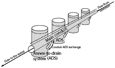
According to Mangin’s model, the karst phreatic zone is made of pipes draining drums (from Marsaud 1996).
-
Groundwater storage in the phreatic zone does not exist. The karst network drains groundwater from the vadose zone. The particularly high heterogeneity in the infiltration zone may act as a buffer delaying most of the recharge (Lastennet et al. 1995). In this model, the epikarst with its local and seasonal saturated part plays an important role in storage. Except in the epikarst part, this model does not really differ from Martel’s (1921), already very popular in the speleologist approach, that reduces it to a pipe network.

It is clear enough that any of these models can be generalized to every karst aquifer. Depending on the rock texture and structure and the geological history of the formation, one of these models dominates. For instance, storage in the rock matrix of karst developing in well-crystallized Palaeozoic and Jurassic limestones in Europe cannot be efficient because of the very low permeability, contrary to karst developing in Cretaceous chalk and Tertiary–Quaternary coral limestones which are very permeable.
The infiltration zone and the epikarst give other particular hydrological properties to karst aquifers (Mangin 1974a; Bakalowicz 1995, 2003). The epikarst may be compared to the skin of the karst, an exchange zone between the bio-atmosphere and the karst itself, storing groundwater locally and seasonally in a perched saturated zone where CO2 is produced and transported in solution and as an air-water mixing in the infiltration and phreatic zones (Fig. 3). The recharge occurs either directly into the infiltration zone from points breaking the epikarst, sinkholes and swallow holes, or through the epikarst. The saturated part of the epikarst delays the diffuse infiltration by percolating through vertical cracks at its base and feeds actual evapotranspiration of the plant and soil cover. It also discharges by overflow into vertical conduits during the rainy season.

The epikarst (from Mangin 1974a)
It is then possible to summarize the general functioning of karst aquifers as shown in Fig. 4. The different flows through the aquifer may be identified by their chemical, isotope and/or hydraulic characteristics (Bakalowicz et al. 1974; Mangin 1974a; Bakalowicz 1979, 1994), as well as by tracing experiments (Atkinson et al. 1973).

General conceptual model describing the various types of recharge and functions in the vadose and phreatic zones of a karst system (Bakalowicz 2003)
Conceptual consequences
Because the void size is much more heterogeneous than in any other aquifer and the karstic voids are organized, defining a representative elementary volume, REV, as for other types of aquifer, is not possible. An elementary unit volume representative of the heterogeneity may be defined for fractured medium, taking into account voids from microporosity to fractures and faults. However, in karst the integrated conduit network is a supplementary heterogeneity that is organized at a different scale. It can be taken into consideration only by considering it as a whole, which is the drainage unit of a spring or a group of springs eventually including a point recharge from a non-karstic area. Mangin (1974b) defined it as the karst system, which must be the comprehensive hydrological reference in any hydrogeological study.
Most of time, the hydraulic heterogeneity created by a conduit cannot be observed from a potentiometric map: the probability that a well intersects a conduit is generally so low that such maps in karst may show an almost continuous medium, without any regional visible effect of the drainage system. This is particularly well known in chalk aquifers classically considered as non karstic (Lepiller 1993), when tracing tests indicate the presence of conduit flow conditions and when underground works reveal the existence of wide cavities. The effects of the karst network are shown by up-scaling at the scale of the whole karst system when analyzing the aquifer functioning.
A karst system is similar to a river catchment area, with comparable properties, defined by an extension, contours and boundary conditions. Extension and contours are imposed by geology and geomorphology; generally, they cannot be determined directly from geological maps and from water level maps.
Among the boundary conditions, the type of recharge is probably the most important. Point, concentrated recharge may or may not occur from surface rivers through swallow holes. Consequently, according to the system analysis approach, a karst system may be binary or unary (Fig. 5), i.e. with a non-karstic part providing an allogenic recharge to the karst aquifer, or without a non-karstic part, the recharge being autogenic (Jakucs 1977). In a binary karst system, the karst aquifer is a part of the karst system. Consequently, not only the type of conduit pattern depends on it, but also the functioning, the vulnerability and consequently the conditions of exploitation and protection.

Binary and unary karst systems (from Marsaud 1996)
Methodological approaches
Because the classical tools in hydrogeology are based on well observations such as piezometric measurements and pumping tests, potentiometric maps and hydraulic data from tests are considered as the references in all the hydrogeology studies. This is a key point: some hydrogeologists consider that observation wells and pumping tests are very important information sites and that the functioning of the whole aquifer can be inferred from well observations, eventually compared to spring hydrographs (see for instance Bonacci 1982, 1995), while others consider wells as local information, often disconnected from the conduit network and not really representative of the organization and functioning of the karst aquifer (see discussion in Ford and Williams 1989; Jeannin and Sauter 1998; Smart 1999; Worthington 1999). It is quite obvious that in karst aquifers the classical hydrogeological approach is generally inoperative because of the inability to show the existence of conduits.
At the opposite extreme, the speleological approach considers that only a direct exploration of caves is able to give an appropriate representation of karst media. It is easy to show that approach is not more efficient, because it mostly describes abandoned conduits and ignores the storage parts of the aquifer and therefore the functioning of the system is not understood.
The structural approach
The main difficulty deals with the karst network itself, the problem to be solved is how to determine if it exists, where it is located and which role it plays in the functioning of the system. In the classical hydrogeology approach, the detailed description of the geological framework and especially the fracturing distribution was considered as the most efficient way. The basic assumption is that the karst network should be organized in the same way as the fractures are distributed.
This approach was developed during the 70’s by Drogue’s group in France (Grillot 1977; Razack 1980). It allows the use of classical hydrogeology modelling. Eraso (1986) showed that such approach is not sufficient because groundwater flows “take a choice” based on both the connectivity of the discontinuities and the hydraulic gradient existing between the recharge area and the location of the spring. Moreover, the case studies following that method show the difficulty, even the impossibility to infer the karst structure and its role only from the geological framework and fracturing distribution. However, this structural approach may give some local information related either to the functioning or to the structure about the organization of the karst systems.
The functional approach
Quinlan and Ewers (1985) said that in karst studies one tracing test brings much more information than a thousand wells. This is a simile that means that the most appropriate approach to studying karst must show first the effects of the possible conduit network, which location and extent remain unknown, on the functioning of the aquifer at the system level. In fact, because of its characteristics similar to river system basins, karst hydrology must be studied in the same way.
This approach was proposed first by Mangin (1974a) and developed during the 70s and 80s by the Moulis team, which proposed to analyze karst system functioning from hydrodynamics (Mangin 1974a, 1984; Marsaud 1996), hydrothermics (Andrieux 1976), and various natural tracers such as aquatic microfauna (Rouch 1980), major inorganic dissolved solids (Bakalowicz 1979; Plagnes 1997) and isotopes (Bakalowicz et al. 1974). It is now currently being used in karst hydrogeology studies in Europe (Andreo et al. 2002; Mudry 1991; Aquilina et al. 2004) and North America. Most karst hydrogeologists now investigate carbonate aquifers by using at least some of these methods.
An investigation methodology
The proposed methodology is an integrating “medical” approach of karst systems similar to physician’s when making a check-up followed with a diagnosis (Bakalowicz 1997). The karst hydrogeologist has at his disposal a set of methods to explore and study karst aquifers, in order to describe their functioning and their structure from the system scale to a local scale. The methods are as follows:
-
Characterisation of the structure by geological and morphological analyses,
-
Delineation of the karst system by means of geological mapping, tracing tests and water balance,
-
Characterisation of their lump functioning:
-
Characterisation of their local functioning:
Thus a karst system can be characterised by its structure and functioning, that allows the hydrogeologist to assess the efficiency of its conduit network in draining the phreatic zone and to estimate the resource and the exploitable storage.
Even if all methods are not necessarily used, the study of a karst system should be undertaken with several of them. It should be based on data obtained during the recharge season as well as during low stage, in order to obtain information on infiltration and the recharge process during floods and on the phreatic zone during the dry season. In many developing countries, the main springs are monitored, commonly not continuously, for instance at a weekly time step, which is not adequate for most karst springs subject to rapid and important flow rate variations. Moreover, local information, i.e. groundwater level in a well or a cave, chemical composition of dripping water in a cave, tracer-breakthrough curves, should be interpreted in the frame of the whole system in order to take into account its representativity.
Consequently, in academic as well as in practical investigations, the comprehensive study of karst systems necessarily takes a long time, at least several months, and requires various skills. There is not a magic single hydrogeological method able to give appropriate answers.
Modelling approaches
At the end of this first step of the hydrogeological study, the karst system is delineated and characterised in its functioning and structure. Some of its local character may also be described and representativity discussed. However, it is still far from reaching its objective, such as exploitation procedures or protection schemes.
In the second step, a conceptual model should be built, summarizing all the knowledge concerning the karst system and its relations with its geological and human environment. This model may follow the general model (Fig. 4) describing the various types of recharge and functions in the phreatic zone. However, at that stage, the model can be only qualitative, or semi-quantitative. For example, the relative parts of point recharge and fast and slow infiltration must be quantified, both during flood events and during the hydrological year.
Currently, in order to identify and quantify the different components of flow, river and spring hydrographs are deciphered, using chemical or isotope data typical of the different types of flow, and the mass balance equation. This method cannot be applied to the decomposition of karst spring hydrographs because the basic assumptions are not at all available in karst aquifers: the system must be linear and in permanent flow conditions, what is generally not realized as shown by the different types of chemographs associated with spring hydrographs (Fig. 6). Pinault et al. (2001) proposed a method based on inverse modelling which considers functions taking into account the two conditions or non linearity and non permanent flow. The analysis is done on the annual hydrograph from which is extracted the impulse response by time series techniques. The impulse response is then deciphered in the different components identified by their characteristic tracer. This is a very powerful method, now applied to some more examples (Pinault et al. 2001), but requiring important sets of data.

The different types of chemographs corresponding to karst spring hydrographs
The use of reservoir models is a more simple and classical way which is being explored with software packages such as GARDENIA (Thiery 1988) or VENSIM, which has been used in surface hydrology for some years (Hreiche et al. 2002) and presently is being tested on karst aquifers. These models only work with hydrologic data, what makes their use easier, but their fitting is not really easy.
Analytical models are now applied to karst aquifers. The equivalent porous media models (see for instance Scanlon et al. 2003) may roughly simulate spring hydrographs or the evolution of the piezometric surface. This approach, rejected by most of karst hydrogeologists because the effects of conduits are neglected, was finely discussed by Huntoon (1995). Therefore, a double porosity model, with matrix and fractures or conduits (Malozewski et al. 1998; Jeannin and Sauter 1998) was developed to simulate karst aquifers. This kind of model is evoluting with a triple porosity, with matrix, fracture and conduits (Maloszewski et al. 2002) or a conduit system in a continuum model (Liedl and Sauter 1998).
Methods of exploiting and protecting karst groundwater resources
The last step deals with exploitation and protection schemes. All of the characteristics described here make karst aquifer difficult to study, requiring so many data of various kinds, and incorporate problems that influence hydrogeologists and decision makers to avoid their exploitation. A good example is given by Avias (1995), when he fought for promoting the exploitation of groundwater from the Lez karst spring for Montpellier, France water supply instead of surface water from the Rhone River.
The two main practical problems are related to i) successful results of drilling wells, and ii) the high vulnerability of karst medium to pollution.
Concerning the very low probability for high pumping rate wells, it must be pointed out that karst aquifers are particularly favourable for very large exploitation rates at unique sites close to springs: the Lez spring, France: 1.5 m3/s; the Figeh spring, Damascus, Syria: 3.5 m3/s (Kattan 1997).
The Ombla spring power plant, Dubrovnik, Croatia is certainly the most noteworthy water work project in karst (Bonacci 1995; Milanovic 2000): an underground dam up to 100 m asl creates underground storage upstream of the spring which is located at sea level, covering 4.8 km2, containing around 3×10⁶ m3 of water in the upper 40 m. The groundwater is planned to be used both for water supply and electric power production. The average discharge of the spring, around 22 m3/s (minimum: 4; maximum: 104), depending on the reference years, will allow an exploitation flow rate around 45 m3/s.
These few examples show that despite the high seasonal discharge variability karst aquifers may be exploited at flow rates close to the average, even higher for a short time. This seasonal overexploitation is possible because of two important properties: possible very large storage capacity and yearly recharge related to a mean groundwater residence time commonly shorter than one year. These properties make karst aquifers probably the most suitable for an active management of groundwater resources (Detay 1997). The main difficulty remains, the method of determining the appropriate location for a productive well. Practically any geophysical method is unable to reveal the location of a conduit deeper than 40–50 m. The only efficient way commonly used in France is an electro-magnetic positioning with a solenoid or a magnet put in the conduit by a diver: the method is precise enough for locating successful wells up to 300 m in depth.
The second aspect deals with aquifer vulnerability, often considered as the major fault of karst. However, vulnerability is related to the short residence time of the main part of the recharge. Thus, groundwater is easily renewed, and consequently the effects of accidental pollution do not last for a long time in the same way that breakthrough of a tracer is restored to initial conditions after only weeks or months. Concerning diffuse pollution, compared to porous aquifers, it seems that there is no cumulative, long-term effect because of the rapid recharge; therefore any change in practices, for example in fertilizing or with waste water treatment, shows a rapid change in water quality. This was discussed by Plagnes and Bakalowicz (2002). Finally, the high vulnerability of karst aquifers is related to their very interesting quality of fast recharge and discontinuous storage.
Mapping the vulnerability is a present day challenge. In Europe, a specific working group in the frame of COST Organization (Co-operation in Science and Technology), COST 620, “Vulnerability and Risk Mapping for the Protection of Carbonate (Karst) Aquifers”, chaired by Zwalhen (2003), presents the different national ways of protecting the karst groundwater resource. It proposes the most appropriate methods for studying and mapping the vulnerability in order to protect the resource according to the European Water Framework Directive published in 2000. The European Approach to vulnerability, hazard and risk mapping is based on an origin pathway-target model, which applies for both groundwater resource and source protection.
This new approach follows two methods developed and applied in Switzerland and France during the 90’s: the EPIK (Doerfliger et al. 1999) and RISKE (Petelet-Giraud et al. 2000) methods, which are based on a multi-criterion analysis. The reference criteria are related to epikarst, protective cover, infiltration and the karst network in EPIK, and to the rock characteristics, infiltration, soil, the karst development and epikarst (RISKE). The second method is formed as a preliminary and rough approach to EPIK, which maps in detail on a distributed-parameter model, the values for each criterion. The important work done by COST 620 will certainly involve new investigations and results not only in vulnerability mapping, but also in terms of land management and practices for protecting natural resources in karst regions.
Hard points: key points to be solved
Knowledge of karst aquifers greatly improved during the last decades, partly because numerous methods were adapted to karst and organised into a methodology. But a large part of the progress is due to the introduction of a conceptual approach of karst taking into account its specificities as an aquifer, which clearly makes the distinction between karst and non karst aquifers. However, some points are not yet really cleared up. They deal with theoretical aspects, the structure of karst aquifers and their functioning, their modelling, and with practical problems.
Structure and functioning of karst aquifers
Everybody agrees that on the whole, in infiltration and phreatic zones, the karst processes develop conduits organized in a hierarchical way, the conduit network, comparable to the organization of flow in a surface river system. However, does the conduit network drive the whole groundwater flow? Or does a part of the groundwater flow through rock porosity and cracks, which are never concerned by karst processes, as known in some recent coral limestone islands, or in chalk?
Most karst aquifers are multiphased due to changing base levels. Among these changes, the rising of the base level undoubtedly increases the storage capacity of karst phreatic zones which can be evaluated by different methods. However, the role of infiltration in storing groundwater or at least in delaying a part of the recharge needs to be evaluated from more study cases. If the storage function is related to large karst cavities with high head loss connections to the conduits, the so-called annex-to-drain systems (Mangin 1974a), rather than to fissured rock matrix, the phreatic zone should be hydraulically discontinuous. These points are not easy to illustrate, because the representativity of observations from boreholes is questionable. Progresses could be done by using multi-packer wells, if these local hydrodynamic and natural tracing data are compared to the information related to the whole system (Jeannin 1995).
The double porosity model (Malozewski et al. 1998; Jeannin and Sauter 1998) fits well to most of the observations, particularly to tracing experiment data. However, another model may also explain the same data in a very different way: viscous flow in conduit (Field 2002). This model assumes that a viscous layer exists between the flow itself and the conduit wall; it corresponds to the referred model for developing scallops in karst conduits (Curl 1974); therefore, the viscous flow model is particularly interesting for future investigations and developments.
In most cases, the functioning of karst aquifers is obviously non linear. Some of these non-linearities are related to threshold effects (Pinault et al. 2001) either in the epikarst or in the exchanges between conduits and annex-to-drain systems. Moreover, the non-linearity could be due to the changes in flow regime: turbulent vs. laminar flow, Darcy vs. non-Darcy conditions and more generally conduit hydraulics vs. flow in porous media. These directions are being explored.
All these points are related to modelling karst aquifers. In fact different attempts propose (Palmer et al. 1999) to model (i) the functioning of karst aquifers, and (ii) the generation of the karstic structure. Different approaches, which are still under development, are explored in these two directions. The functioning is simulated by:
-
a lumped parameter approach on the system scale, black box and grey box models, for simulating spring hydrographs or effects of climate variation or change and exploitation impact,
-
distributed parameter approaches by multi-continuum models for simulating local behaviour.
In both cases, modelling is used to test the validity of some assumptions and to provide tools for managing the groundwater resource and storage. Some classic models simulating flow in aquifers by a distributed parameter approach, such as MODFLOW, are sometimes used in karst: even if their simulated results fit well to observations, the basic assumptions are not at all verified in karst, as discussed by Huntoon (1995). The parameter values, unknown at most of the nodes, are only equivalent parameters. Karst functioning modelling remains at its early beginning.
Modelling the generation of the conduit network is the real originality in karst hydrology. It was initiated by solution experiments for simulating the development of conduit networks (Ewers 1982). Presently flow and transport models simulate conduit development (Dreybrodt 1988), but not yet, conduit network. The simulation of conduit network development depends on that of the initial joint network which is still in its infancy (Jourde et al. 2002).
Practical problems
The estimation of the storage capacity in the phreatic zone is biased when Mangin’s method is used for analysing the recession flow. The volume calculated by integrating the low stage hydrograph following Maillet’s law, named “dynamic storage” by Mangin corresponds to the flowing volume at the beginning of the low stage. From lab experiments, it seems that it should be an underestimate of the phreatic volume (Marsaud 1996) depending on the importance of storage below the spring level. For the moment, the storage capacity cannot be evaluated by another independent method. This volume must be known, at least approached in order to propose a plan for exploiting groundwater in a sustainable way by pumping during short times at rates higher than the natural discharge. There is no alternative method for evaluating the storage capacity.
The determination of the conduit location, at least the prediction of the zones with high hydraulic conductivity is certainly the main difficulty which has to be faced for successful drilling in karst. Geological methods such as geophysics and mapping of fracture distribution are efficient enough to locate drillings in productive zones. Eraso’s method may help only when tectonics were not too complicated with only a single major phase. When two or more constraining phases occurred, the theory of fracturing does not apply and the method is inoperative. Finally, these methods do not help in locating very high flow rate boreholes at depth. There presently is no geophysical method able to reveal the presence of a conduit at depth. Technological developments are required either for improving some geophysical methods, georadar or electrical soundings, or for developing diving robots for exploring flooded conduits from karst springs.
Karst aquifers seem favourable to increase their storage capacity: underground dams plugging caves are known in South China. Their efficiency was never evaluated. Ombla underground dam is a very interesting experimental project, more complex than the Chinese equivalents (Milanovic 2000). Other experiments should be done in order to propose an alternative to river dam.
The storage may also be increased by regulating point recharge from river swallow holes. A reservoir dam on a Mediterranean river crossing limestones in southern France increased the dry season discharge so that the flow input at swallow holes increased during the dry season, favouring recharge and consequently the low stage flow. This case of artificial recharge is being evaluated by Ladouche et al. (2002).
The aquifer vulnerability has been a European challenge for the last two decades (COST-Action 65 1995; Doerfliger et al. 1999; Daly et al. 2002). The different practices for determining zones of protection and the corresponding regulations were listed, compared and criticized. Presently different methods based on multicriterion analysis are been tested and compared for mapping the vulnerability of karst aquifers (Zwahlen 2003) in order to propose protection documents to decision makers. European regulations are evolving to take into account the European Water Directive and the conclusions of COST 620. However, these multicriterion methods are not easy to operate because it is difficult to characterize independently the criteria from field surveys. The recent developments show that some of the proposed methods are too complicated to be applied and checked easily by water authorities and local administrations. No efficient method for delineating groundwater protection zones in karst presently exists.
Intractable aspects of karst aquifers
Because of the complexity of karst medium, many think that every karst aquifer is currently considered as being representative of only itself. If it is, karst aquifers will not be compared nor safely exploited. Fortunately, they present common characteristics in their conduit organization and in groundwater flow conditions. This allows the use of common exploration and exploitation methods.
However one problem looks intractable: the framework and location of the functioning karst conduit system. The geological and geophysical methods give information that contributes only in increasing the probability of locating a conduit or more generally a cavity containing groundwater. Never the whole functioning conduit network could be determined in the same way as a map of a cave system. In the same way, a potentiometric map built from observations in wells does not really inform the reader about the situation of the conduit network, even if the number of wells is large. Consequently, it will not be possible to simulate a karst aquifer by a distributed model representing the reality at every node. Despite that difficulty, the functioning of a karst system may be approached by a distributed digital model that can reasonably simulate its spring hydrograph, although the conditions prevailing in karst aquifers are far from most of the basic conditions of the model. The best example is the popular software package MODFLOW, which is used for simulating karst spring hydrographs or water level in a well, but unable to properly simulate the potentiometric surface of a karst aquifer (see for instance Palmer et al. 1999).
Lumped models are an interesting and efficient alternative to simulating karst spring hydrographs. These models with reservoirs are particularly suitable to the management of groundwater resources in karst: they are easier to use and they require more simple sets of data. Moreover as they must be used at the system scale what is the most appropriate scale for managing resources, groundwater quantity and quality may be managed in a realistic manner even if the internal geometry and flow conditions remain partially unknown. This is possible because the dynamics of karst systems are rapid, renewing most of the storage within a hydrologic year or less, which makes the effects of seasonal variations or exploitation rapidly observable in the spring flow regime.
The spring is the only place where one can obtain information on the functioning of the whole system, consequently the organization of conduits and storage. Consequently, if the main spring cannot be monitored, discharging directly in a river, a lake or the sea, the system cannot be simulated nor managed properly. Technological and scientific developments are waited for the next years in the field of coastal karst aquifers.
References
Andreo B, Carrasco F, Bakalowicz M, Mudry J, Vadillo I (2002) Use of the hydrodynamic and hydrochemistry to characterise carbonate aquifers. Case study of the Blanca-Mijas unit (Malaga, southern Spain). Environ Geol 43:108–119
Andrieux C (1976) Le système karstique du Baget. 2. Géothermie des eaux à l’exutoire principal selon les cycles hydrologiques 1974 et 1975. (The Baget karst system. 2. Groudwater geothermics at the main spring during 1974 and 1975 hydrological years). Annales scientifiques de l’Université de Besançon, 3, 25:1–26
Aquilina L, Ladouche B, Dörfliger N, Bakalowicz M (2004) Water circulation, residence time and water-rock interaction in a complex karst hydrosystem (Thau lagoon, S-France). Ground Water 41(6):790–805
Atkinson TC, Harmon RS, Smart PL, Waltham AC (1978) Palaeoclimatic and geomorphic implications of 230Th/234U dates on speleothems from Britain. Nature 272:24–28
Atkinson TC, Smith DI, Lavis JJ, Whitaker RJ (1973) Experiments in tracing underground waters in limestones. J Hydrol 19:323–349
Avias JV (1995) Gestion active de l’exsurgence karstique de la source du Lez (Hérault, France) 1957–1994. (Active management of the Lez karst spring, Hérault, France, 1957–1994). Hydrogéologie 1:113–127
Bakalowicz M (1975) Géochimie des eaux karstiques et karstification. (Karst groundwater geochemistry and karstification). Annales de Spéléologie 30(4):581–589
Bakalowicz M (1979) Contribution de la géochimie des eaux à la connaissance de l’aquifère karstique et de la karstification. (Contribution of water geochemistry to the knowledge of karst aquifer and karst processes). Doctorat ès Sciences naturelles Thesis, P. et M. Curie Paris-6, Paris, 269 pp
Bakalowicz M (1992) Géochimie des eaux et flux de matières dissoutes. L’approche objective du rôle du climat dans la karstogénèse. (Water geochemistry and dissolved solid flux. The objective approach of climate part in the genesis of karst). Karst et évolutions climatiques. Hommage à Jean Nicod. Presses Universitaires de Bordeaux, Talence, pp 61–74
Bakalowicz M (1994) Le massif d’Arbas—Paloumère. Géologie, hydrogéologie et évolution karstique. (The Arbas – Paloumère karst system. Geology, hydrogeology and karstic evolution). In: S. Boyer and J. Flandin (Editors), Le tour de la Coume Ouarnède en 24 cavités. Spelunca Librairie, Editions GAP, La Ravoire, pp 19–28
Bakalowicz M (1994) Water geochemistry: water quality and dynamics. In: Stanford J, Gibert J, Danielopol D (eds) Groundwater ecology. Academic Press, pp 97–127
Bakalowicz M (1995) La zone d’infiltration des aquifères karstiques. Méthodes d’étude. Structure et fonctionnement. (The infiltration zone of karst aquifers. Study methods. Structure and functioning). Hydrogéologie 4:3–21
Bakalowicz M (1997) Hydrogéologue versus spéléologue, ou de qui relève l’étude et l’exploration des eaux souterraines karstiques ? (Hydrogeologist vs caver, or who should be in charge of the study and exploration of karst groundwater ?). 6ème Colloque d’Hydrologie en Pays calcaire, La Chaux de Fonds (Suisse), 13–17 aôut 1997
Bakalowicz M (2003) Epikarst, the skin of karst. Conference on Epikarst, The Karst Water Institute, Shepherdstown, West Virginia (in press)
Bakalowicz M (2004) Comments on “Carbon isotope exchange rate of DIC in karst groundwater by R. Gonfiantini and G.M. Zuppi”. Chem Geol 204(1–2):183–185
Bakalowicz M, Blavoux B, Mangin A (1974) Apports du traçage isotopique naturel à la connaissance du fonctionnement d’un système karstique—teneurs en oxygène 18 de trois systèmes des Pyrénées, France. (Natural isotope tracing as an informer of karst system functioning. Oxygen-18 content of three karst systems in the Pyrenees, France. ). J Hydrol 23:141–158
Bonacci O (1982) Specific hydrometry of karst regions. Advances in Hydrometry, IAHS Publ. no 134, pp 321–33
Bonacci O (1995) Groundwater behaviour in karst: example of the Ombla spring (Croatia). J Hydrol 165(1–4):113–134
Clauzon G (1982) Le canyon messinien du Rhône: une preuve décisive du “dessicated-deep model” (Hsü, Cita et Ryan, 1973). (The Rhone river Messinian canyon: a definite demonstration of the “dessicated-deep model”). Bull Soc Géol Fr 24 (7):597–610
COST-Action 65 (1995) Karst groundwater protection. Final Rep. EUR 16547, European Commission
Curl RL (1974) Deducing flow velocity in cave conduits from scallops. NSS Bull 36(2):1–5
Cvijic J (1893) Das Karstphänomen. Versuch einer geographischen Morphologie. (Karst phenomena. Geographical morphology). Geogr. Abhandlungen von A. Penck, Vienna, V, 3, pp 217–230
Cvijic J (1918) Hydrographie souterraine et évolution morphologique du karst. (Underground hydrography and morphological evolution of karst). Recueil des Travaux de l’Institut de Géographie Alpine, Grenoble, 6, pp 375–429
Daly D, Dassargues A, Drew D, Dunne S, Goldscheider N, Neale S, Popescu IC, Zwahlen F (2002) Main concepts of the European approach for (karst) groundwater vulnerability assessment and mapping. Hydrogeol J 10(2):340–345
Detay M (1997) La gestion active des aquifères. (Active management of aquifers). Masson, Paris, 416 pp
Doerfliger N, Jeannin PY, Zwahlen F (1999) Water vulnerability assessment in karst environments: a new method of defining protection areas using a multi-attribute approach and GIS tools (EPIK method). Environ Geol 39(2):165–176
Dreybrodt W (1988) Processes in karst systems. physics, chemistry and geology. Springer series in physical environment 4. Springer, Berlin Heidelberg New York, 288 pp
Dreybrodt W (1998) Limestone dissolution rates in karst environments. Bulletin d’Hydrogéologie, Centre d’Hydrogéologie, Université de Neuchâtel, 16:167–183.
Drogue C (1974) Structure de certains aquifères karstiques d’après les résultats de travaux de forage. (Structure of certain karst aquifers from drilling data). CR Acad Sci Paris, série III (278):2621–2624
Eraso A (1986) Metodo de prediccion de las direcciones principales de drenaje en el karst. (Method for predicting the main directions of drainage in karst). Kobie 15:15–122
Ewers RO (1982) Cavern development in the length and breadth. PhD Thesis, McMaster University, Hamilton, Ontario
Field M (2002) The QTRACER2 program for tracer-breakthrough curve analysis for tracer tests in karstic aquifers and other hydrologic systems. EPA/600/R-02/001, National Center for Environmental Assessment, US EPA, Washington, DC
Ford DC, Williams PW (1989) Karst geomorphology and hydrology. Academic Division of Unwin Hyman Ltd, London, 601 pp
Gascoyne M, Benjamin GJ, Schwarcz HP, Ford DC (1979) Sea-level lowering during the Illinoian glaciation: evidence from a Bahama “blue hole”. Science 205:806–808
Grillot JC (1977) A propos de méthodologies d’analyses quantitatives, à l’échelle régionale, de champs de fractures: premiers résultats d’une application. (Methodologies for quantitative analyses, at a regional level, of fracture fields: first results). Revue de Géographie Physique et de Géologie Dynamique, XIX (3):219–234
Grund A (1903) Die Karsthydrographie. Studien aus Westbosnien. (Karst hydrology. Studies in western Bosnia). Geogr. Abhandlungen von A. Penck, Leipzig, VII, 3, pp 1–201
Hreiche A, Mezher D, Bocquillon C, Dezetter A, Servat E, Najem W (2002) Parallel processing for a better understanding of equifinality in hydrological models. Proceedings IEMSS 2002, vol.1, Lugano, Switzerland
Huntoon PW (1995) Is it appropriate to apply porous media groundwater circulation models to karstic aquifers? In: El-Kadi AI (ed) Groundwater models for resources analysis and management, chapter 19, pp 339–358
Jakucs L (1977) Morphogenetics of karst regions : variants of karst evolution. Akademiai Kiado, Budapest
Jeannin PY (1995) Action COST 65 - Projets Bure et Hölloch (Suisse): cadre théorique, position des problèmes, présentation des sites étudiés et des données disponibles. (COST Action 65 – The Bure and Hölloch projects (Switzerland): theoretical framework, problems, description of study sites and available data). Bulletin d’Hydrogéologie, Centre d’Hydrogéologie, Université de Neuchâtel, 14:53–81
Jeannin PY, Sauter M (1998) Analysis of karst hydrodynamic behaviour using global approach: a review. Bulletin d’Hydrogéologie, Centre d’Hydrogéologie, Université de Neuchâtel 16:31–48
Jourde H, Cornaton F, Pistre S, Bidaux P (2002) Flow behavior in a dual fracture network. J Hydrol 266:99–119
Kattan Z (1997) Environmental isotope study of the major karst springs in Damascus limestone aquifer systems: case of the Figeh and Barada springs. J Hydrol 193:161–182
Kiraly L (1997) Modelling karst aquifers by the combined discrete channel and continuum approach, 6th Conference on limestone hydrology and fissured aquifers, session on modelling karst aquifers. Université de Franche-Comté, Sciences et Technique de l’Environnement, La Chaux-de-Fonds, pp 1–26
Kruber A (1900) Phénomènes du Karst (ou du calcaire) en Russie. (Karst or limestone phenomena in Russia). Semlewjedjenie, Moscou, VII, 4, pp 1–34
Ladouche B, Dörfliger N, Poubet R, Petit V, Thiery D, Golaz C (2002) Caractérisation du fonctionnement des systèmes karstiques nord-montpelliérains. Rapport du programme 1999–2001 - Buèges. (Characterization of northern Montpellier karst system functioning. 1999–2001 programme report – the Buèges River). BRGM/RP-51584-FR, 200 pp
Lastennet R, Puig JM, Emblanch C, Blavoux B (1995) Influence de la zone non saturée sur le fonctionnement des systèmes karstiques. Mises en évidence dans les sources du Nord-Vaucluse. (Influence of the non saturated zone on the functioning of karst systems. Demonstration from springs in northern Vaucluse, France). Hydrogéologie 4:57–66
Lepiller M (1993) Réflexions sur l’hydrogéologie karstique de la Craie du bassin de Paris à partir d’exemples régionaux (Normandie, Gâtinais). (Comments on karst hydrogeology in the chalk of the Paris basin from regional examples (Normandie, Gâtinais)). Hydrogéologie 2:151–161
Liedl R, Sauter M (1998) Modelling of aquifer genesis and heat transport in karst systems. Bulletin d’Hydrogéologie, Centre d’Hydrogéologie, Université de Neuchâtel, 16:185–200
Llamas MR (1975) Noneconomic motivations in ground-water use; hydroschizophrenia. Ground Water 13(3):296–300
Maloszewski P, Benischke R, Harum T, Zojer H (1998) Estimation of solute transport parameters in a karstic aquifer using artificial tracer experiments. In: Simmers PD (ed) Shallow groundwater systems. International contribution to hydrogeology. Balkema, Rotterdam, pp 177–190
Maloszewski P, Stichler W, Zuber A, Rank D (2002) Identifying the flow systems in a karstic-fissured-porous aquifer, the Schneealpe, Austria, by modelling of environmental 18O and 3H isotopes. J Hydrol 256:48–59
Mangin A (1974a) Contribution à l’étude hydrodynamique des aquifères karstiques. (Contribution the hydrodynamics of karst aquifers). Annales de Spéléologie, 29(3):283–332; 29(4):495–601; 30(1):21–124
Mangin A (1974b) Notion de système karstique. (The concept of karst system). Spélunca Mémoires (8):64–68
Mangin A (1978) Le karst, entité physique, abordé par l’étude du système karstique. (Karst as a physical unit, from the study of the karst system). Le karst, colloque de Tarbes, 17–18 octobre 1978, AGSO, pp 21–37
Mangin A (1984) Pour une meilleure connaissance des systèmes hydrologiques à partir des analyses corrélatoire et spectrale. (For a better knowledge of hydrological systems by means of correlation and spectrum analyses). J Hydrol 67:25–43
Mangin A (1994) Karst hydrogeology. In: Stanford J, Gibert J, Danielopol D (eds) Groundwater ecology. Academic Press. pp 43–67
Marinelli M (1904) Nuove osservazioni sui fenomeni di tipo carsico nei gessi appennici. (New observations on phenomena of karstic type in gypsum of Apennines). 5o Congresso geografico italiano, Naples, avril 1904, II, 1, pp 950–1086
Marsaud B (1996) Structure et fonctionnement de la zone noyée des karsts à partir des résultats expérimentaux. (Structure and functioning of the saturated zone of karsts from experimental results). Doctorate Thesis, Paris XI, Orsay, 305 pp
Marsaud B (1997) L’interprétation des essais de pompage adaptée aux aquifères karstiques. (Interpretation of pumping tests adapted to karst aquifers). Hydrogéologie (3):31–42
Martel EA (1902) Universalitité et ancienneté des phénomènes caverneux du calcaire. (Universalitity and ancient age of cave phenomena in limestone). Congrès Assoc. Française pour l’Avancement des Sciences, Montauban, août 1902, p.1144. In: Martel EA (1905) La Spéléologie au XXème siècle, Spelunca, VI, 44, pp 561–565
Martel EA (1921) Nouveau traité des eaux souterraines. (The new treatise on groundwater). O. Doin, Paris, 838 pp
Martel EA (1936) Les Causses majeurs. (The main Causses). Artières et Maury, Millau, 510 pp
Meus P, Ek C (1999) Tracing technique as a contribution to karstology: past experiences, new directions., 1st Nerja cave Geology Symposium, Malaga
Milanovic PT (2000) Geological engineering in karst. Zebra, Belgrade, 347 pp
Mojsisovics von (1880) Die Karst-Erscheinungen. (Karst phenomena). Zeitschrift des deutschen Alpenvereins
Mudry J (1990) Les courbes flux chimique-débit et le fonctionnement des aquifères karstiques. (Chemical mass flow vs. discharge and the functioning of karst aquifers). J Hydrol 120(1–4):283–294
Mudry J (1991) L’analyse discriminante, un puissant moyen de validation des hypothèses hydrogéologiques. (Discriminant factor analysis, a powerful tool for the validation of hydrogeological assumptions). Revue des Sciences de l’Eau 4 (1):19–37
Palmer AN (1981) A geological guide to Mammoth Cave National Park. Zephyrus Press
Palmer AN (2000) Hydrogeologic control of cave patterns. In: Klimchouk A, Ford DC, Palmer AN, Dreybrodt W (ed) Speleogenesis. Evolution of karst aquifers. Nat Speleol Soc, Huntsville, pp 77–90
Palmer AN, Palmer MV, Sasowsky ID (eds) (1999) Karst modeling. Proc Symp, Charlottesville, Virginia, 24–27 Feb. 1999. Karst Water Inst., Spec Publ 5, pp 1–265
Penck A (1903) Über das Karstphänomen. (On karst phenomena). Verbreit. Naturwis. Kenntniss, Vienne, 1
Petelet-Giraud E, Doerfliger N, Crochet P (2000) RISKE: méthode d’évaluation multicritère de la cartographie de la vulnérabilité des aquifères karstiques. Application aux systèmes des Fontanilles et Cent-Fonts (Hérault, Sud de la France). (RISKE: a multicriterion assessment method for mapping the vulnerability of karst aquifers. Application to Fontanilles and Cent-Fonts karst systems, Hérault, southern France). Hydrogéologie (4):71–88
Pinault JL, Bakalowicz M, Plagnes V, Aquilina L (2001) Inverse modelling of the hydrological and the hydrochemical behaviour of hydrosystems: characterization of karst system functioning. Water Resour Res 37:2191–2204
Pinault JL, Ladouche B, Doerfliger N, Bakalowicz M (2001) Modélisation inverse des relations pluies-débits et des chimiogrammes. Applications aux systèmes karstiques des Fontanilles et des Cent Fonts (Hérault, France). (Inverse modelling of rainfall – discharge relationships and of chemographs. Application to Fontanilles and Cent Fonts karst systems, Hérault, France). Proc 7th Conf on Limestone hydrology and fissured media, Besançon, France, 20–22 Sept 2001, pp 289–292
Plagnes V (1997) Structure and functioning of karst systems. Characterisation by means of water geochemistry. Doctorate Thesis, Université Montpellier II, Montpellier, 372 pp
Plagnes V, Bakalowicz M (2002) The protection of a karst water resource from the example of the Larzac karst plateau (south of France): a matter of regulations or a matter of process knowledge? Eng Geol 65(2–3):107–116
Quinlan JF, Ewers RO (1985) Ground water flow in limestone terranes: strategy rationale and procedure for reliable, efficient monitoring of ground water quality in karst areas. 5th national symposium and exposition on aquifer restoration and ground water monitoring. National Water Well Association, Columbus, Ohio, pp 197–234
Razack M (1980) Approche quantitative de l’effet d’échelle sur le relevé de la fracturation par photo-interprétation dans l’étude de la géométrie des réservoirs fissurés. (Quantitative approach of the scaling effect on fracturation analysis by interpreting aerial graphs for the study of the geometry of fissured reservoirs). Mémoires hors série de la Société géologique de France, 11:81–90
Rouch R (1980) Les Harpacticides, indicateurs naturels de l’aquifère karstique. (Harpacticoidea, natural tracers of karst aquifers). Mémoires hors série de la Société géologique de France, 11:109–116
Scanlon BR, Mace RE, Barrett ME, Smith BD (2003) Can we simulate regional groundwater flow in a karst system using equivalent porous media models? Case study, Barton Springs Edwards aquifer, USA. J Hydrol 276(1–4):137–158
Smart CC (1983) Hydrology of glacierised alpine karst. PhD Thesis, McMaster University, Hamilton, Ontario, 343 pp
Smart CC (1999) Subsidiary conduit systems: a hiatus in aquifer monitoring and modelling. In: Palmer AN, Palmer MV, Sasowsky ID (eds) Karst modelling. Symposium proceedings, Charlottesville, February 24–27, 1999. Karst Water Institute, Spec Publ 5, pp 146–157
Smith DI, Atkinson TC (1976) The erosion of limestones. In: Ford TD, Cullingford CHD (eds) The science of speleology. Academic Press, London, pp 151–177
Thiéry D (1988) Forecast of changes in piezometric levels by a lumped hydrological model. J Hydrol 97:129–148
Worthington SRH (1999) A comprehensive strategy for understanding flow in carbonate aquifers. In: Palmer AN, Palmer MV, Sasowsky ID (eds) Karst modelling. Symposium proceedings, Charlottesville, February 24–27, 1999. Karst Water Institute, Spec Publ 5, pp 30–37
Zanna P del (1899) I fenomini carsici nel bacino dell’Elsa. (Karst phenomena in the Elsa basin). Boll Soc Geol It XVIII:1–11
Zwalhen F (ed) (2003) Vulnerability and risk mapping for the protection of carbonate (Karst) aquifers. Final Rep COST 620
Acknowledgments
I would like to express my grateful thanks to my colleagues, especially Dr Valérie Plagnes, Dr Nathalie Dörfliger, Dr Philippe Crochet and Pr Séverin Pistre, for our fruitful discussions, to the reviewers who contribute in improving the manuscript, and to Perry Olcott, HJ managing editor, who improved the English writing.
Author information
Authors and Affiliations
Corresponding author
Rights and permissions
About this article
Cite this article
Bakalowicz, M. Karst groundwater: a challenge for new resources. Hydrogeol J 13, 148–160 (2005). https://doi.org/10.1007/s10040-004-0402-9
Received:
Accepted:
Published:
Issue Date:
DOI: https://doi.org/10.1007/s10040-004-0402-9