
Abstract
Flood disaster is a critical issue in Bangladesh, with the most severe cases of flooding occurring in July and August. Regular river floods affect 20% of the country, increasing up to 68% in extreme years. After such catastrophic floods, the policy, action, strategy, and plan for flood disaster risk reduction have been developed. The floods of 1987, 1988, 1998, 2004, and 2007 were particularly catastrophic, resulting in large-scale destruction and loss of lives. After the 1988 flood, a strategy of “living with the floods” was developed to achieve sustainable agricultural development and this concept was integrated into the country’s Flood Action Plan. In 1998, 68% of Bangladesh was inundated by floods. The earthen embankments were unable to give protection against the floods in 1998, even against some medium floods in the 1990s. Catastrophic disasters in the 1990s affected institutional development, giving rise to an integrated water resource management program. In 2004, Bangladesh experienced devastating floods from July to September, with 56,000 km2 (about 38% of the country) inundated. Consequently, a more comprehensive risk reduction program was established to effectively address the complexity of water management. This paper looks at the flood history of Bangladesh, the different flood phenomena and approaches used after 2004, and the ways climate and social change affected flood disaster mitigation and people’s livelihood. It then discusses an integrated program for disaster risk reduction and resource management.
Access provided by Autonomous University of Puebla. Download chapter PDF
Keywords
14.1 Introduction
Because of weather and topography, floods occur almost every year in Bangladesh. Heavy rainfall and the warm and tropical climate trigger flooding. Annual rainfall is at least 2000 mm in most parts of the country, except in the relatively dry western region where about 1600 mm of rainfall occurs. There are four prominent seasons: winter (December to February), pre-monsoon (March to May), monsoon (June to early October, major rainy season), and post-monsoon (late October to November). In addition, rainfall in India, Nepal, China, and Bhutan drains into Bangladesh through three mighty rivers─the Ganges, the Brahmaputra, and the Meghna (commonly known as the GBM river system, one of the largest river systems in the world) and their tributaries. Bangladesh is located at the lower part of the GBM river basin (Fig. 14.1). Almost half of the area is within the 10-m-above-mean-sea-level range and floodplains make up 80% of the country’s landscape. Thus, the monsoon and the flat topography are regarded as major causes of floods.

The Ganges, Brahmaputra, and Meghna basins (Mirza 2002)
Flooding brings fertile soil from upstream. As rice is the staple and as traditional rice-based agriculture is dependent on the monsoon rain and flood-conveyed fertile soil, Bangladeshi farmers welcome the regular floods during the monsoon season. However, the increased volume of rainfall caused by climate change has intensified the flood problem (Brouwer et al. 2007). Catastrophic disasters provide the turning points of policy, action, strategy, and plan for flood disaster risk reduction. In addition, social changes also affect these risk reduction interventions. In this research paper, the flood history of Bangladesh is reviewed with the focus on the 2004 catastrophic flood, highlighting the need for integrated management for flood disaster risk reduction. Possible integrated management approaches to reduce flood disaster risks are discussed.
14.2 Flood History
Catastrophic floods occurred in Bangladesh in 1988, 1998, and 2004. If the extent of inundated area and the number of people affected are more than what the annual floods bring about, the floods are considered extreme. Twenty percent of the country is inundated by regular floods, with the area affected increasing up to 68% in years of extreme flooding. Approximately 37, 43, 52, and 68% of the area is inundated by floods with return periods of 10, 20, 50, and 100 years (DMB 2010). Floods inundating more than 30% of the country occurred in 1974, 1987, 1988, 1998, 2004, and 2007 (Fig. 14.2). The largest recorded flood in terms of depth and duration was in 1998, where 68% of the country was under water for several months (FFWC 2005; Nishat et al. 2000). The flood in 1988 also brought extreme damage to Bangladesh as inundation area reached 61%. Both floods in 1998 and 1988 were caused by a combination of heavy rainfall within and outside Bangladesh and the peak flows of the major rivers. As Fig. 14.2 shows, the inundation rate in 1988 and 1998 stood out as there was large-scale destruction and loss of lives.

(Source Department of Disaster Management 2014)
Percentage of inundated area over the time period 1954–2013
In addition to area, duration of inundation also affects the extent of damage. In the 1998 flood, 53 districts (nearly 100,000 km2 area) were inundated for 65 days (Shaw et al. 2013). Figure 14.3 shows the duration of flooding, defined as the number of consecutive days at or above the danger level registered for the water level station in Dhaka from 1909 to 2009 (Thiele-Eich et al. 2015). For Dhaka, 32 events were noted between 1909 and 2009, with an average duration of 16.3 days (Thiele-Eich et al. 2015).

Duration of flood events in Dhaka (If two flood events are separated by only 6 days recording below-danger level, these are considered one continuous event marked by green stars adapted from Thiele-Eich et al. 2015: 1205)
Figure 14.4 shows the number of deaths and people rendered homeless by the floods since 1980. Because of the gentle slope and water velocity of the rivers, the floods were not fast enough to deprive people’s lives directly. However, the inundation damaged the farmland, resulting in death due to starvation. In addition, lack of access to safe drinking water contributed to disease epidemics.

(Source CRED 2016)
Flood-affected people (population in 2016: 163,000,000)
More than 2,000 people died in 1987 and 1988 and more than 35 million people were affected by the floods in 1988 and 2004. Table 14.1 is prepared by selecting the number of deaths that exceed 750 from Fig. 14.4 and adding the area of inundation from Fig. 14.2.
Population density also relates to high rates of mortality and morbidity (Cash et al. 2013). Bangladesh has 166 million people (in 2014) and has a high population density, 1,277.4 persons/km2 (CIA 2014). Because of population pressure and land scarcity, many poor communities are forced to live in flood-prone areas. Seventy percent of the population live in regions at risk of floods; 26% reside in regions at risk of cyclones (DMB 2010). Almost 74% of the country’s agricultural output comes from utilizing the fertile basin of the GBM rivers (Brammer and Khan 1991). In addition, the increasing population (Fig. 14.5) makes it difficult for people to survive the food shortage during the floods.

(Source World Bank 2016, http://www.multpl.com/bangladesh-population)
Bangladesh population (162.95 million, December 2016)
Climate change is expected to change the frequency, intensity, duration, and magnitude of flooding (IPCC 2007). It is also likely to create food supply problems because Bangladesh is highly dependent on monsoon farming (Shukla 2003). Food production is being disrupted by floods more frequently and more severely than before (Douglas 2009). As population increases, more and more people have no recourse but to live in flood-prone areas, thereby increasing the number of flood victims.
The floods in 1988, 1998, and 2004 were the turning point. A flood disaster risk reduction program was crafted in this country that gained independence in 1971. The phases are divided into four.
14.2.1 Phase I (1955–1971): Post-disaster Recovery to Protect Agricultural Land
Official flood management in Bangladesh started in the 1960s. During this phase, protecting the agricultural land was the main focus because agriculture was the main industry. Development of infrastructure was given high priority. The Coastal Embankment Project (CEP) in 1960–1970 has been the largest structural intervention in the coastal areas. Flood control, drainage, and/or irrigation (FCD/I) projects have been implemented by the Bangladesh government since the mid-1960s. Embankments, drainage channels, and sluice gates were constructed, with a total coverage area of 5.37 million ha (Rahman and Salehin 2013). The Bangladesh Water Development Board (BWDB) built more than 100 polders in the coastal area in the early sixties to protect designated areas from tidal floods, salinity intrusion, and sedimentation. Though the projects gave positive impacts (i.e., increase in agricultural production and economic activities; reduced damage to infrastructure inside the protected areas) (Rahman and Salehin 2013), the scale was too large and needed a large amount of time and money. In spite of existing projects, even moderate floods caused lots of damage to the people and agricultural land. Although the embankments were able to prevent the intrusion of salinity water, disturbances in the river flow proved inconvenient for the local people and they could not fully utilize the water resource. The local people destroyed some of the embankments for their own convenience. As a result, these structures were not able to function as envisioned. Moreover, the poor operation and maintenance of the embankments decreased fish stocks and caused deposition of silt in the riverbed as well as on agricultural land. Consequently, non-structural measures were also considered as a means for mitigating flood damage. Established in 1972, the Flood Forecasting and Warning Center of BWDB was responsible for making flood forecasts and flood warning during the flood season (Rahman and Salehin 2013).
14.2.2 Phase II (1971–1988): Shift to Small-Scale Projects
In the 1970s–1980s, large-scale polderization was promoted to meet the increasing demand of agricultural production. However, this has resulted in severe drainage congestion and waterlogging (Fig. 14.6). Around the same time, demand for shrimp has increased in the international market, jacking up its price. As polders are suitable for intensive shrimp farming, salt water was allowed to enter under polder shrimp culture. Land previously used for agriculture and mangroves were used for shrimp farming (Islam 2006). The government focused on water resource development and management in addition to protecting agriculture. The National Water Plan (NWP) was formulated in 1982 and finalized in 1986. In addition to the large-scale structural solutions, the government adopted small and medium-scale FCD projects to provide early benefits.

Poor polder drainage (left) and sedimentation resulted in inundations marked by levels of discoloration in buildings (middle) (Kapotakho in Khulna District, 2014)
14.2.3 Phase III (1988–1998): Living with the Floods
This phase is characterized by the shift from flood control to flood management and the change in focus from structural solutions to a combination of structural and non-structural measures. There were particularly catastrophic floods in 1987 and 1988, resulting in large-scale destruction and loss of lives. Awareness of the need for a more integrated, multisector approach to surface water management became evident in the late 1980s. As a result, various flood assessment studies were conducted and there was recognition that although floods are a hazard, they can also be beneficial in many aspects. The strategy of “living with the floods” was applied, which is the more traditional way of dealing with these floods (Rahman and Salehin 2013). This concept of “living with the floods” for sustainable agricultural development was integrated into the Flood Action Plan (FAP) and has become widespread from 1990 to 1996. The FAP was initiated to save the country from devastating floods such as the two consecutive floods that occurred in 1987 and 1988 (Haque 1993). Gradually, FAP regional studies paid attention to the interdisciplinary nature of flood management. What came out was an integrated water management plan that covered issues such as flood, drainage, irrigation, navigation, the environment, and the economy.
14.2.4 Phase IV (1998–2004): Integrated Water Resource Management
The earthen embankments were unable to give protection against severe floods in 1998 and even against some medium floods in 1991, 1993, and 1995 (Salehin et al. 2007). The disasters in the 1990s affected institutional development. A real start toward “integrated” management took place in the realms of policy and practice. The National Water Policy (NWP) was prepared in 1999 and subsequently the National Water Management Plan (NWMP) was finalized in 2001 (Rahman and Salehin 2013). The NWP makes clear the government’s intention to implement the policy of integrated water resource management (IWRM) and to pursue all necessary measures to manage the country’s water resources in a comprehensive, integrated, equitable, and environmentally sustainable manner. The NWP also focuses on stakeholder participation. The NWMP is a framework under which the ministries define the strategies; agencies, departments, and local bodies that will be involved in the projects.
14.2.5 Phase V (2004 to Date): Shift from Response and Relief Practice to More Comprehensive Risk Reduction Approach
In 2004, Bangladesh experienced one of the most devastating floods in its nearly 50 years of existence. About 38% of the country went under water (DMB 2010). After this catastrophe, the government resolved to improve disaster response and preparedness at the local level, with provision of immediate rescue resources, emergency funding mechanisms, better information management, and contingency planning (DER 2004). A paradigm shift in disaster management from conventional response and relief practice to a more comprehensive risk reduction system slowly took place (Zimmermann et al. 2009).
Based on climate change and social and economic conditions, the measures and plans for flood disaster risk reduction have shifted as follows:
-
From “response and recovery” to “preparedness” (Fig. 14.7)
Fig. 14.7 
Shift in focus from “response and recovery” to “all stages”
-
From “control” to “management” to “comprehensive risk reduction”
-
From “structural measures” to “comprehensive measures,” including non-structural ones
-
From “government” to “multi-stakeholder participation” (Fig. 14.8).
Fig. 14.8 
Shift from “government-led approach” to “multi-stakeholder participation”


The clear trend is toward integrated management for disaster risk reduction.
14.3 Review of the 2004 Flood
There are several turning points in the development of an approach to flood disaster risk reduction. Since the flood in 2004 was relatively recent and since it is pivotal in the shift to a more comprehensive and integrated approach toward flood risk reduction, the details of this particular disaster are reviewed.
The 2004 flood lasted for 3 months, from July to September. The government reported massive damage in 39 out of 64 districts; 56,000 km2, about 38% of the country’s total area, were inundated (WARPO 2005), including 8,000 km2 of agricultural land. About 2,500 km of embankments were damaged and about 74 primary school buildings were washed away (GoB 2010). More than 1,200 primary schools were destroyed or severely damaged and another 2,000, though not inundated, were damaged through their use as official flood shelters. Thus, nearly 18,000 primary schools were affected (LCG 2004). In total, impacts of the flood were felt by 24,000 educational institutions, including primary schools, high schools, colleges, and madrasa (LCG 2004).
By mid-September, about 800 people have died of various diseases, the result of having no access to clean water. Thirty million people lost their homes. Economic losses reached about 2,200 million US dollars (GoB 2010). Food scarcity became a common phenomenon in flood-affected areas during and after the flood. Crop failure has significant negative effects on household income (GoB 2010).
Flooding conditions vary in different areas because of topography and prevailing weather. Annually, the northern, central, and northeastern districts are subjected to 2–3-m flood depths for 4–5 months during the monsoon (July–September) (Ali 2007). These areas were also inundated in the 2004 flood. Several eastern districts (Noakhali, Comilla, and Sylhet) remained under deep floodwaters until the end of September.
The western districts of Rajshahi, Chapai Nawabganj, Natrore, and Pabna are in the Ganges river floodplain and the northwestern districts of Dinajpur and Rangpur regions are in the Teesta-Karotoa river floodplains. These regions experienced moderate to high flooding in July.
The southern districts of Khulna, Barisal, and Patuakhali have low flood risk and experience occasional tidal surges.
The eastern hills in Chittagong, Rangamati, and Bandarban districts and the southwestern region comprising Jessore, Satkhira, Meherpur, Chuadanga, and Joypurhat districts are relatively flood-free (Ali 2007).
Forty percent of the capital city, Dhaka, was under water in July 2004. The flood had a serious impact on children’s education in the Dhaka area because 7% of the school children dropped out from school (Afrin 2015). In the urban areas, slum dwellers living on poorly drained land suffered the most. Since pure drinking water was not available during the flood, 100,000 people in Dhaka suffered from diarrhea (Afrin 2015).
In the rural area, around 52% of the people are engaged in agriculture, mostly as labor. As a result, landless laborers and small farmers were the most severely affected (GoB 2010). The rice crop was devastated and so were important cash crops such as jute and sugarcane (Fig. 14.9).

(Source Based on OCHA/ReliefWeb 2004)
Flood depth and inundation map, 24 July 2004
14.4 Four Types of Flood-Prone Areas: Different Phenomena in Different Areas
Since flooding phenomena and damage are different in various areas, the flood disaster risk reduction approach applied in each area also differed. In this section, the different floods, their causes, and the measures implemented are reviewed in order to come up with a more comprehensive and integrated management system.
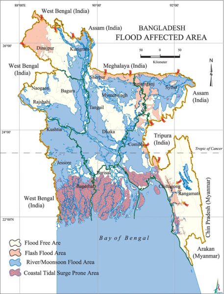
Bangladesh experiences several types of flood, generally categorized into four (see Fig. 14.10 for the location of these flood types):

(Source http://en.banglapedia.org/images/thumb/0/06/FloodAffectedArea.jpg/457px-FloodAffectedArea.jpg)
Different flood phenomena in different areas of Bangladesh
-
i.
River floods (also called river bank erosion or monsoon floods) along major rivers during the monsoon season (June–September).
-
ii.
Flash floods caused by overflowing of hilly rivers in eastern and northern Bangladesh (April–May and September–November).
-
iii.
Urban floods (also called normal floods, pluvial floods, or rainfed floods) caused by drainage congestion during heavy rains.
(Although it is included in the river flood area, it is separately discussed in this paper inasmuch as the phenomena and measures along the major rivers and those in Dhaka are different.)
-
iv.
Coastal floods caused by storm surges (April–May and October–November) and tidal surges (April–May and October–November in addition to June–September during high tide).
-
(i)
River floods occur along major rivers such as the Brahmaputra and Ganges during the monsoon season from June to September every year. They are caused by erosion and bank overflow. According to BWDB, about 1,200 km of river banks are actively eroding and about 100,000 people live on these sites (Zimmermann et al 2009). About 80% of the country is vulnerable to extreme river floods. The most destructive river ones occur when peak discharges of both the Brahmaputra (June/July) and the Ganges (August/September) coincide. Structural and non-structural measures have been developed against river floods. Indigenous ways such as raising/elevating their houses with plinth (Fig. 14.11) and placing sand bags to prevent erosion on the river bank (Fig. 14.12) are common and effective in mitigating the annual river floods.
Fig. 14.11 
Houses on plinth. A woman shows the height of the recent flood (Sundarganj District, Gaibandha Division, 2014)
Fig. 14.12 
Sand bags and concrete blocks are placed on the embankment to prevent erosion (Fulcchari District, Gaibandha Division, 2014)
Migration is the major non-structural measure implemented in river flood areas. Flood is one of the main reasons of migration in Bangladesh (Khatun 2013). Loss of life directly due to a river flood is a rare occurrence; however, erosion and inundation deprive farmers of their farmland and livelihood, and the low yield of crops and the ensuing food shortage put their families on the brink of starvation. Seasonal migration to find jobs and food is needed to avoid starvation. Usually, the villagers spend a few weeks to a month to prepare for migration. This seasonal/circular migration is an important strategy. In addition to seasonal migration, families move several times when they lose their land. Riverbank erosion displaces 50,000–200,000 people in Bangladesh every year (Mehedi 2010). The number of internal migrants to urban cities is also increasing (Planning Commission 2010) because of increasing population and extreme river flooding caused by climate change. Food shortages are already serious issues in the rural areas, particularly in the eroded areas. The poor people migrate to Dhaka City and generally settle in the slums (Asfar 1999).
-
(ii)
Flash floods and the associated landslides are the major disasters in the hilly regions of Bangladesh because of its physiology, hydrology, and climatology (Sarker and Rashid 2013). Flash floods occur in the north and in the east, particularly in the Meghna River basin, and in the southeastern hilly areas in Chittagong. The northeast districts, such as Sylhet, Moulvibazar, Sunamganj, Habiganj, Kishoreganj, Netrokona, Rangamati, Bandarban, and Khagrachari are the main flash flood-prone districts. Flash floods in the foothills and Haor basin damage agriculture and, to a lesser degree, infrastructure. Localized heavy rainfall, as well as water flow from the upstream Meghalaya hills in India through the hilly rivers, results in a sudden rise in river flows within a short time, causing flash floods in April–May and September–November. Since flow velocity is fast, a flash flood can occur within a few hours and can be over within 5–6 h. It recedes rapidly, within minutes to a few hours, and often dissipates quickly. However, flash floods with high hydraulic force and erosive power frequently damage crops, property, and fish stocks in wetland areas. In the northeast and southeast regions, flash floods often affect the winter rice crop at harvesting stage during April–May. With rainfall forecast and timely warning, the local people are able to receive flash flood information through public announcement systems (Fig. 14.13) and neighbors in advance. They have enough time to bring their property to higher ground and go to a safe place (Fig. 14.13).
Fig. 14.13 
Farmers are given advance information about the floods through a public announcement system
In 2002, 2004, 2007, 2009, and 2010, flash floods devastated the rice crop of northeast Haor region (MoDMR 2014). This was attributed to the changing timing of flash floods. Recently, as flash floods come earlier than usual, farmers do not get to harvest their rice on time. Therefore, fast-growing rice varieties become crucial as farmers need enough time to harvest their crop after flood warnings have been issued. Moreover, land use changes, deforestation, hillside cutting, and unplanned infrastructural development influence the kind of mitigation measures applied to lessen the impact of flash floods and landslides (Sarker and Rashid 2013).
-
(iii)
Urban floods, also called rainfed floods, occur in many parts of the country but mainly in Dhaka.
With intense rainfall, the natural drainage system cannot carry the runoff and temporary inundation results. This phenomenon is increasingly being observed in the urban areas (BFSC 2014; Rahman et al. 2014). The drainage systems have been disturbed by various human interference such as construction of roads, river courses, water bodies, etc. The culprit is unplanned and rapid urbanization.
-
(iv)
The coastal area is highly vulnerable to coastal flooding, which is caused by storm surges and astronomically high tide. The southern part of Bangladesh is mainly coastal, with a coastline of about 800 km. About 32% of the land in Bangladesh fall in the coastal zone. This area is found in the Bay of Bengal where shallow continental shelves extend to about 20–50 km. The eastern coastline is conical and funnel-shaped. Because of the topography, the height of storm surges generated by cyclonic storms in this area is higher than those reported in other coastal areas in the world. The highest recorded storm surge caused by super cyclones was 10–15 m, which caused flooding in the entire coastal belt. The coastal area was continuously hit by severe cyclones in the 1990s and 2000s. The flood that caused a huge loss of human lives and property occurred on April 29, 1991. This catastrophic cyclone affected a large construction project, including 21 coastal polders. The CERP was implemented from June 1996 to June 2003. The overall project objective was to secure life, property, crops, and livestock along the cyclone-prone coastal areas. Cyclone Sidr (November 15, 2007), a 10-year-return-period cyclone, and Cyclone Aila (May 25, 2009) provided recent examples of devastating storm surges. Both cyclones posed extensive loss and damage in lives and livelihood and caused long-term inundation and salinity intrusion in vast areas.


In addition to the storm surge floods, tidal floods also occur in coastal areas. Tidal floods are caused by the water-level rise due to the combination of storm surge and the astronomically high tide. The sea-level rise of normal high tide is caused by the southwest monsoon wind during the June to September monsoon season. This rise in water level can cause extreme flooding in coastal areas, particularly when a storm surge coincides with the normal high tide.
Floods caused by erosion also occur along rivers in the coastal areas. It is not destructive in the short term. However, long-term inundation can destroy farm land, which may result in food shortage. Since the duration of inundation is long, the local people live there as long as they can and then migrate to other areas instead of going to evacuation shelters. Increased river bank erosion and saline water intrusion in the coastal areas are likely to displace hundreds of thousands of people. They will be forced to migrate, often to slum areas in Dhaka and other big cities (Ministry of Environment and Forests 2009a).
The frequency of “above-normal or above-common” floods has shown an increasing trend since 1950 (Hofer and Messerli 2006). Both sea-level rise and other climate-induced changes could submerge one-fifth of Bangladesh (Stern 2007). Sea-level rise has already caused land erosion and increased salinity in the coastal areas, affecting biodiversity, food production, and fisheries (Khatun 2013). Climate change impact on natural disasters and agricultural system is critical, since these two aspects are closely related to life, livelihood, and food security. Frequent hydro-meteorological disasters such as floods, cyclones, and storm surges disrupt agricultural systems and cause shortage of food (Parvin et al. 2015).
As mentioned in the section on flood history, the government of Bangladesh has paid great attention to coastal planning and land use management since the 1950s because of two major reasons: preservation of its rich resources and mitigating the devastating cyclone and storm disasters. The coastal zones have been considered areas of enormous economic potential because of the country’s biodiversity and natural resource endowment. Therefore, these areas have been used intensively (Islam et al. 2011) despite the threat of disasters. After a number of cyclones hit the coastal zones in the 1960s, protective measures were started. Not much attention was given if the disaster was deemed not destructive in the short term (e.g., river floods). Since coastal land use management is considered one of the key elements for national development (Parvin et al. 2017), many institutional, structural, and non-structural measures have been developed to protect the coastal areas from devastating disasters such as cyclones and storms. Structural measures, such as building cyclone shelters and raising houses with plinth were implemented. The cyclone shelter is useful during floods caused by storm surges because flood duration lasts for several days (Figs. 14.14 and 14.15). As to non-structural measures, a warning system was put in place and assistance from domestic and international organization, NGOs, and the government was secured. Some of the measures developed to lessen cyclone damage are likewise used for flood disaster risk reduction (Fig. 14.16).

A house with the floor raised higher (left) and the original structure with traditional plinth (right), Goainghat, Sylhet, April 2017

A cyclone shelter houses both livestock (first floor) and people (second floor). A warning system with lights that signify levels of danger has been installed. Sarankhola, Bagerhat District, Khulna Division, August 2014

A loudspeaker from a mosque is used to warn people about changes in weather conditions. Gabura Union, Satkhira, Khulna Division, August 2014
The main features of the four types of flood and the corresponding mitigation measures are summarized in Table 14.2.
14.5 Need for an Integrated Management Approach for Flood Disaster Risk Reduction
The flood in 2004 highlighted the need for an integrated management approach for flood disaster risk reduction. As agriculture is a major industry in Bangladesh, annual flooding is not considered a disaster and is welcomed by farmers and fisherfolk. However, it has harmful effects and threatens human security because of changes in the social and climate scenarios. An increasing population has to be considered a social issue in flood-prone areas. In Bangladesh, the most densely populated country in the world, it is very difficult to relocate people from flood-prone areas to places with less exposure to flooding. They are even forced to live in locations that are more flood-prone. Because of overpopulation, some farmers give up living in agricultural areas near the river; they go to urban areas and become part of the labor force. Many of these migrants work in the textile industry, which has recently become more popular. The population is still increasing. Though one major non-structural measure for mitigating annual/common floods is migration or evacuation, this is not suitable in cases of extreme flooding. The increasing incidence of extreme floods caused by climate change must be considered. In 2004, the number of homeless families was high despite 38% inundation in the area; this was much less than figures recorded during other devastating inundation events like those in 1988 (61%) and 1998 (68%) (Fig. 14.4 and Table 14.1).
Though integrated flood management for disaster risk reduction and resource management are critical, mitigation measures should be discussed separately for the different areas inasmuch as the flood phenomena and the social background vary greatly.
14.5.1 River Flood Area
As in coastal flood, the duration of inundation is a typical feature of the river flood. Since inundation period is long (i.e., a few months), there is some discontinuation in farming and education activities. Compared with cyclone and flash flood duration, the period of flooding caused by erosion in the river flood area is longer. Farmers have difficulty cultivating the land, and children are not able to go to school for a few months. The long inundation period affects the economy and disrupts the education system. Even short-term inundation makes it difficult for children to continue their education.
Before the overpopulation problem became critical, people were able to live near the flood area, commuting to the fertile land to farm after the floods. People were pleased with the fertile soil carried by the flood. They enjoy this benefit and manage farming by themselves. However, as the population increased, people were forced to live in the flood-prone area, farming the same way as before. Traditional farming, relying only on flood-conveyed fertile soil, did not produce enough food. Farmers turned to using chemical fertilizers, which affect their health.
Though seasonal and long-term migration to urban cities is considered an adaptive measure, frequent migration makes it difficult for people to accumulate property and continue their children’s education. In this area, in addition to individual efforts, help from external sources is expected.
14.5.2 Flash Flood Area
Flash floods are a recurrent and hazardous phenomenon. It occurs in the northeastern part of Bangladesh. After a flash flood, paddy fields in the hoar area remain under water for half of the year. Farmers can grow paddy only in the dry season. Early flash floods destroy the crop, especially boro rice. In addition to developing short-duration rice varieties, putting a warning system in place is considered effective.
14.5.3 Urban Flood Area
Unplanned urbanization and road construction caused disturbances in the natural drainage system in the urban areas. The result is poor drainage, especially in the capital city, Dhaka. This area gets priority in terms of investment in infrastructure, which can address the flood issues to some extent. As people rely heavily on public works, there is a need to raise individual awareness toward averting flood disasters.
14.5.4 Coastal Flood Area
As in the case of urban areas, flood protection activities often become a flood-causing factor in coastal areas. Embankment and polderization cause waterlogging and erosion, then induce flood inundation. In these locations, the natural environment has to be considered when structural measures (embankments, dikes, polders) are taken. A proper environmental impact assessment must be done to protect the coastal ecosystem and resources.
The coastal area got a lot of attention from international and domestic organizations, NGOs, and governments, which provided external help. The focus was mainly recovery and reconstruction from short-term disasters such as cyclones and storm surges. Recent efforts now include comprehensive projects that involve flood disaster risk reduction, disaster preparation, all stakeholder participation, etc. In many cases, the agencies work independently, thus some programs/projects are biased, overlapping, or few. It will be more effective if there is coordination among these organizations, working together and allocating specific roles to each to achieve the target goals.
Since Bangladesh is a deltaic country, the floods have typical features. They are not destructive in the short term, but are rather profitable for farming. However, long-term inundation affects education and economic development. Sometimes, long-term inundation causes starvation indirectly because of food shortages caused by the disruption of farming activities. Maximizing the use of each locality’s characteristics in the four different areas can bring about an effective integrated flood disaster risk reduction and resource management scheme.
14.6 Conclusion
Bangladesh is a flood-prone country because of its topography and climate. Floods in Bangladesh do not threaten human security directly. As almost 50% of the area is within 10 m above mean sea level and the floodplains make up 80% of the landscape, river velocity, and therefore flood velocity, is not fast. The people are able to utilize the flat topography, rainwater, and flood-conveyed fertile soil for farming, and flood is rather considered a benefit. Seventy percent of the population of Bangladesh thus depends on agriculture. However, recent changes in the social milieu and climate begin to affect human security. Social change such as rapid population forced more people to live in flood-prone areas. In addition, climate change has critical impact on flood inundation duration and area coverage. Long-term inundation disturbs agriculture and causes food shortage in both rural and urban areas, and people die of starvation. Thus, floods in Bangladesh do not directly affect people’s lives; however there is that big possibility to threaten human security indirectly.
The catastrophic floods resulted in the development of the country’s policy, action, strategy, and plan for flood disaster risk reduction. The years 1987, 1988, 1998, 2004, and 2007 saw large-scale destruction and loss of lives. The 2004 flood became the turning point to shift to a more comprehensive and integrated approach for flood risk reduction. In the various regions, different flood phenomena such as river floods, flash floods, urban floods, and coastal floods were seen, necessitating specific measures in each region. In the river flood area, duration of inundation affected people’s livelihood. External help in this area is not much, considering that this type of flood is not as destructive as a flash flood or that the resulting economic loss is not as big as that observed in an urban flood area or a coastal area. In the flash flood area, timing of floods is a serious concern since flooding occurs during the harvest season. Damage is less if farmers are able to harvest their crops before the water comes. In the urban area, poor drainage system caused by unplanned urbanization makes the situation worse. However, since Dhaka is the capital city, it gets priority in getting mitigation support. The coastal area is also prioritized because of the need to protect the country’s rich ecosystem from salinity intrusion and destructive cyclones and storm surges. There is thus a long history of these protection efforts in Bangladesh. Analyzing the different flood phenomena and assessing mitigation measures in the different regions is effective in understanding the complexity of water management and how climate and social changes affect flood disaster interventions and people’s livelihood.
References
Afrin S (2015) Livelihood pattern of flooded families in Bangladesh: a study in two villages. Dhaka University Institutional Repository, Institute of Social Welfare and Research, University of Dhaka, Dhaka (Bangladesh)
Asfar R (1999) Is migration transferring rural poverty to urban areas? An analysis of longitudinal survey data of Dhaka city. Paper presented at the workshop ‘Changes and Determinants of Urban Poverty.’ Grameen Trust, Grameen Bank, Dhaka (Bangladesh)
Ali A Md S (2007) September 2004 flood event in southwestern Bangladesh: a study of its nature, causes, and human perception and adjustments to a new hazard. Nat Haz 40(1):89–111
BFSC (Bangladesh Food Security Cluster) (2014) Contingency plan for flooding. Food Security Cluster, Bangladesh. https://fscluster.org/sites/default/files/documents/FSC%20Bangladesh%20Contingency%20Plan%20for%20Flooding_12.08.2014.pdf (accessed 4 Feb 2019)
Brammer H, Khan HR (1991) Bangladesh country study. In Asian Development Bank (ed) Disaster mitigation: in Asia and the Pacific. Asian Development Bank, Manila (Philippines)
Brouwer R, Akter S, Brander L, Haque E (2007) Socioeconomic vulnerability and adaptation to environmental risk: A case study of climate change and flooding in Bangladesh. Risk Anal 27(2):313–326. https://doi.org/10.1111/j.4539-6924.2007.00884.x
Cash RA, Halder SR, Husain M, Islam Md S, Mallick FH, May MA, Rahman M, Rahman MA (2013) Reducing the health effect of natural hazards in Bangladesh. In Bangladesh: Innovation for universal health Coverage 5, vol 382. www.thelancet.com
CIA (Central Intelligence Agency) (2014) World fact book. https://www.cia.gov/library/publications/the-world-factbook/geos/bg.html. Accessed 23 Oct 2014
CRED (Centre of Research on Epidemiology of Disasters) (2016) EM-DAT The international disaster database. http://www.emdat.be/advanced_search/index.html. Accessed 23 Aug 2016
DDM (Department of Disaster Management) (2014) Flood response preparedness plan of Bangladesh, June 2014. Ministry of Disaster Management and Relief, DDM, Dhaka (Bangladesh)
DER (Disaster and Emergency Response) Sub-Group (2004) Post-flood needs assessment. Summary report, Monsoon floods 2004. DER, Dhaka (Bangladesh), 30 Sept 04
DMB (Disaster Management Bureau) (2010) National plan for disaster management 2010–2015. DMB, Dhaka (Bangladesh)
Douglas I (2009) Climate change, flooding and food security in south Asia. Food Secur 1:127–136
FFWC (Flood Forecasting and Warning System) (2005) Consolidation and strengthening of flood forecasting and warning services, Final report. Volume II—Monitoring and evaluation. Bangladesh Water Development Board, Dhaka (Bangladesh)
GoB (Government of the People’s Republic of Bangladesh) (2010) National plan for disaster management 2010–2015. Disaster Management Bureau, Disaster Management and Relief Division, Dhaka (Bangladesh)
Haque CE (1993) Flood prevention and mitigation actions in Bangladesh: the ‘sustainable floodplain development’ approach. Impact Assessment 11(4):367–390
Hofer T, Messerli B (2006) Floods in Bangladesh. History, dynamics and rethinking the role of the Himalayas. United Nations University Press, Tokyo
IPCC (Intergovernmental Panel on Climate Change) (2007) Climate change 2007: Synthesis report. The Fourth Assessment Report, IPCC. http://www.un-documents.net/ipcc-ar4/syr.pdf. Accessed 4 Feb 2019
Islam MR (2006) Managing diverse land uses in coastal Bangladesh: Institutional approaches. In: Environment and livelihoods in tropical coastal zones: CAB international, pp 237–248. http://www.pg-du.com/cru/wp-content/uploads/2013/12/Hoanh_1845931076-Chapter18.pdf. Accessed 4 Feb 2019
Islam M, Sakakibara H, Karim M, Sekine M, Mahmud Z (2011) Bacteriological assessment of drinking water supply options in coastal areas of Bangladesh. J Water Health 9(2):415–428
Khatun M (2013) Climate change and migration in Bangladesh: golden Bengal to land of disasters. Bangladesh e-J Sociol 10(2):64–79
LCG (Local Consultative Group) (2004) Monsoon floods 2004: post-flood needs assessment. Summary report. Disaster and Emergency Response Sub-Group, LCG, Dhaka (Bangladesh)
OCHA/ReliefWeb (2004) Bangladesh: Monsoon floods 2004—Draft assessment report, 28 July 2004. http://reliefweb.int/report/bangladesh/bangladesh-floods-situation-report-19-jul-2004
Mehedi H (2010) Climate-induced displacement: case study of cyclone Aila in the southwest coastal region of Bangladesh. HumanityWatch, Khulna
Mirza Q (2002) Global warming and changes in the probability of occurrence of floods in Bangladesh and implications. Global Environ Change 12(2):127–138
MoDMR (Ministry of Disaster Management and Relief) (2014) Flood response preparedness plan of Bangladesh, June 2014. Department of Disaster Management, MoDMR, Dhaka (Bangladesh)
MoEF (Ministry of Environment and Forests) (2009a) Bangladesh climate change strategy and action plan 2009, government of the People’s Republic of Bangladesh. MoEF, Dhaka (Bangladesh)
MoEF (Ministry of Environment and Forests) (2009b) Bangladesh climate change strategy and action plan. http://www.moef.gov.bd/climate_change_strategy2009.pdf
Nishat A et al (2000) The 1998 flood: impact on environment of Dhaka City. Ministry of Environment and Forest and IUCN (The International Union for Conservation of Nature), Dhaka (Bangladesh)
Parvin GA, Fujita K, Matsuyama A, Shaw R, Sakamoto M (2015) Climate change, flood, food security and human health: Cross-cutting issues in Bangladesh. In: Habiba U, Hassan A, Abedin M, Shaw R (eds) Food security and risk reduction in Bangladesh. Disaster risk reduction (methods, approaches and practices). Springer, Tokyo (Japan)
Parvin GA, Ali MH, Fujita K, Abedin MA, Habiba U, Shaw R (2017) Land use change in southwestern coastal Bangladesh: consequence to food and water supply. In: Banba M, Shaw R (eds) Land use management in disaster risk reduction. Disaster risk reduction (methods, approaches and practices). Springer, Tokyo (Japan), pp 381–401
Planning Commission (2010) Outline perspective plan of Bangladesh 2010–2021 (vision 2021). Planning Commission, Dhaka (Bangladesh)
Rahman R, Salehin M (2013) Flood risk and reduction approaches in Bangladesh. In: Shaw R, Mallick F, Islam A (eds) Disaster risk reduction approaches in Bangladesh. Springer, Tokyo/New York, pp 65–90
Rahman MM, Hossain MA, Bhattacharya AK (2014) An analytical study of flood management in Bangladesh. IOSR J Eng 4(1):1–6
Salehin M, Haque A, Rahman MR, Khan MSA, Bala SK (2007) Hydrological aspects of 2004 floods in Bangladesh. J Hydrol Meteorol Nepal 4(1):33–44
Sarker AA, Rashid AKMM (2013) Landslide and flashflood in Bangladesh. In: Shaw R, Mallick F, Islam A (eds) Disaster risk reduction approaches in Bangladesh. Disaster risk reduction (methods, approaches and practices). Springer, Tokyo (Japan)
Shaw R, Aminul I, Fuad M (2013) Chapter 3: National perspectives of disaster risk reduction in Bangladesh. In: Disaster risk reduction approaches in Bangladesh. Springer, Tokyo (Japan). https://books.google.co.jp/books?isbn=4431542523
Shukla PR (2003) Climate change and India. University Press India, Hyderabad (India)
Stern N (2007) The economics of climate change: The Stern review. Cambridge University Press, Cambridge
Thiele-Eich I, Burkart K, Simmer C (2015) Trends in water level and flooding in Dhaka, Bangladesh and their impact on mortality. Int J Environ Res Public Health 12(2):1196–1215
WARPO (Water Resources Planning Organization) (2005) National Adaptation Program of Action (NAPA): water, coastal areas, natural disaster and health sector. WARPO, Dhaka (Bangladesh)
WB (World Bank) (2016) http://www.multpl.com/bangladesh-population. Accessed 1 Dec 2016
Zimmermann M, Glombitza K-F, Rothenberger B (2009) Disaster risk reduction programme for Bangladesh 2010–2012. Swiss Agency for Development and Cooperation, Bern, Switzerland
Acknowledgment
The authors wish to thank the Japan International Cooperation Agency (JICA) and the Japan Science and Technology Agency (JST) for their support of the SATREPS Project “Research project on disaster prevention/mitigation measures against floods and storm surges in Bangladesh.”
Author information
Authors and Affiliations
Corresponding author
Editor information
Editors and Affiliations
Rights and permissions
Copyright information
© 2021 Springer Nature Singapore Pte Ltd.
About this chapter

Cite this chapter
Fujita, K., Shaw, R., Parvin, G.A. (2021). After the 2004 Bangladesh Flood: Integrated Management for Flood Disaster Risk Reduction in Four Different Areas. In: Pulhin, J.M., Inoue, M., Shaw, R. (eds) Climate Change, Disaster Risks, and Human Security. Disaster Risk Reduction. Springer, Singapore. https://doi.org/10.1007/978-981-15-8852-5_14
Download citation
DOI: https://doi.org/10.1007/978-981-15-8852-5_14
Published:
Publisher Name: Springer, Singapore
Print ISBN: 978-981-15-8851-8
Online ISBN: 978-981-15-8852-5
eBook Packages: Earth and Environmental ScienceEarth and Environmental Science (R0)