
Abstract
The nearly 7,500 km long coastline of India is remarkably varied and dynamic and displays diverse rock-based, sediment-based and coral-based landforms. Coastal processes along the Indian coasts are controlled largely by monsoons. The Arabian Sea coast differs from the Bay of Bengal coast in several respects. The east coast is wider, with several large deltas, large lagoons, one of the world’s largest mangrove wetland (Sundarbans) and long stretches of sandy beaches backed by dunes or ridges. In comparison, the west coast is more indented with rocky headlands, intervening sandy bays and multiple estuaries. Cliffs and associated features are relatively more common. A large saline marshland and lagoon-barrier complexes (kayals) are some of the noteworthy features along the west coast.
Access provided by Autonomous University of Puebla. Download chapter PDF
Keywords
1 Introduction
The varied tectonic history, underlying lithology, monsoon climate, sea level fluctuations in the Quaternary and modern littoral processes have created a great variety of the coastal landforms along the ~7,500 km long coastline of the Indian Peninsula. The coastline displays diverse rock-based (headlands, sea cliffs and shore platforms), sediment-based (beaches, dunes, sand bars, spits, tidal flats) and coral-based (reefs and atolls) landforms, which vary significantly in their spatial scale and form.
Coastal erosion is a widespread problem along much of the Indian coastline. About 23 % (~1,248 km) of shoreline along the Indian mainland is affected by erosion to various degrees (ICMAM 2009). The problem is relatively more severe on the west coast than on the east coast of India (Table 1). Apart from natural factors, coastal structures (groynes, breakwaters, seawalls, etc.) constructed for coastal protection works and seaport operations are the common causes of coastal erosion in many areas (ICMAM 2009).
2 Coastal Morphology
The Indian coasts comprise nearly 43 % of sandy beaches, 11 % of rocky features with headlands, platforms and cliffs, and 46 % of mud flats and marshy wetlands (ICMAM 2009). Characteristic differences between the east and the west coasts of India in terms of coastal topography, landforms and processes are apparent from Figs. 1 and 2, and Tables 1 and 2. In general, the eastern seaboard comprises long stretches of sandy beaches backed by coastal dunes (active or stabilized) and interrupted by large prograding deltas, whereas the west coast is more indented with rocky headlands, pocket beaches and multiple estuaries. There are also two archipelagos—one in the Bay of Bengal and another in the Arabian Sea (Fig. 2).

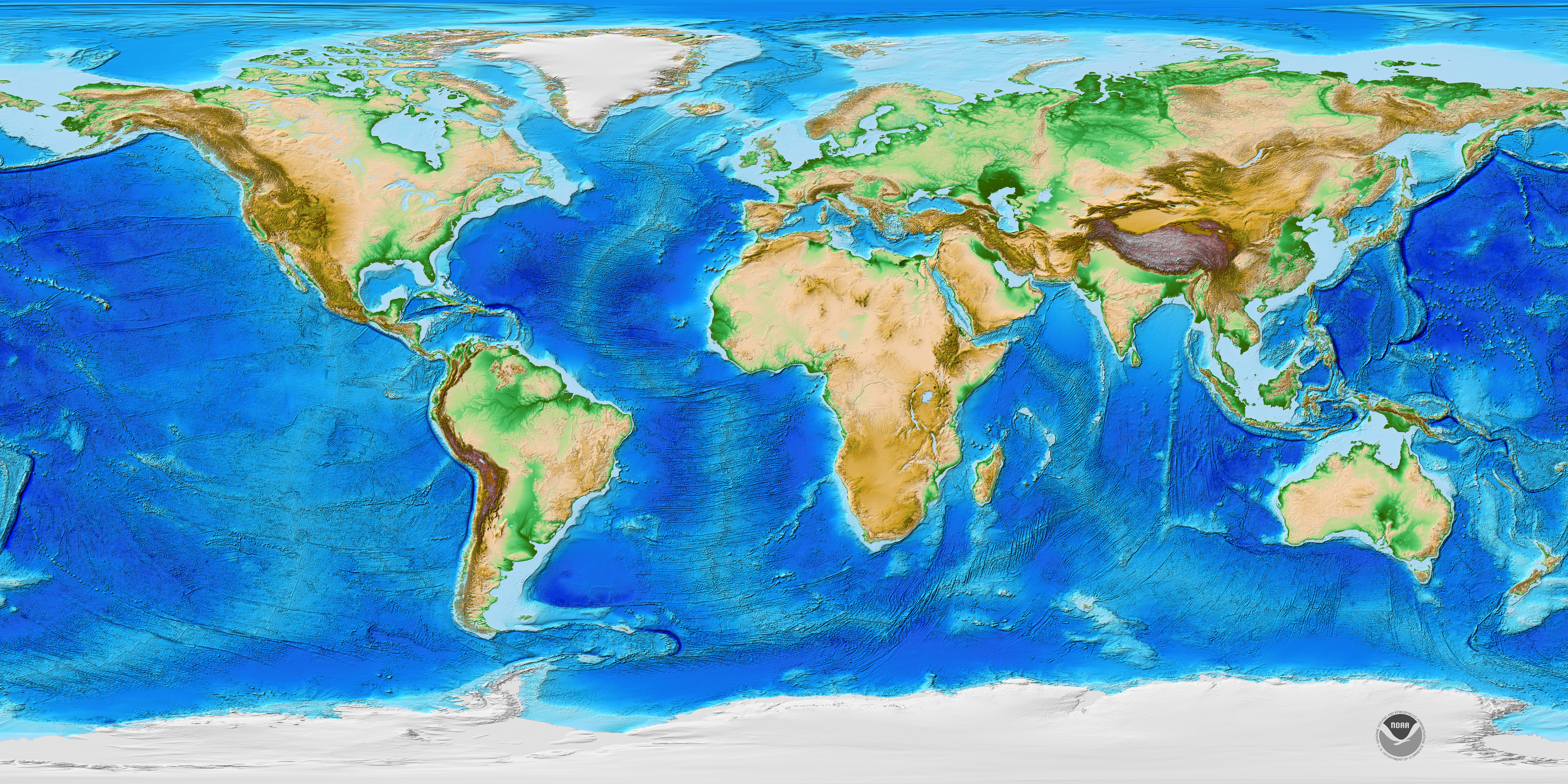
Coastal and offshore morphology along the Indian subcontinent. GKC Gulf of Kachchh, GKB Gulf of Khambhat, GM Gulf of Mannar, PS Palk Strait. The boundary of the Indus and Bengal Fans is approximate. The Bengal Fan, with an area of ~3 million km2, is the largest deep-sea fan in the world. The area of the Indus Fan is ~1.1 million km2. Source of the base map Amante and Eakins (2009). http://www.ngdc.noaa.gov/mgg/image/color_etopo1_ice_low.jpg

Map showing the locations of the noteworthy coastal landforms along the Indian coastline. The inset map shows the major geomorphic coastal divisions discussed in the text. A Archipelago, B Beach, BR Beach/Dune ridges, BW Back water, C Cliff, CR Coral reef, D Delta, DI Deltaic islands, E Estuary, G Gulf, L Lagoon, M Mangrove, MR Marshland, R Red Sand, S Spit (Map courtesy of Vishwas S. Kale)
The eastern coastal plain of India is a 100–130 km wide stretch of land lying between the Eastern Ghat Ranges and the Bay of Bengal. The rivers on the east coast are long with wide and extensive delta formations (Vaidyanadhan 1991) (Table 3). The Ganga-Brahmaputra, Mahanadi, Godavari, Krishna and Kaveri Rivers drain this eastern coastal plain, giving rise respectively to four major offshore sedimentary basins—Bengal, Mahanadi, Krishna-Godavari, and Kaveri, with sediment thickness reaching at places to more than 5 km (Murthy et al. 2012).
The eastern continental margin is a mature margin, and came into existence between 140 and 120 Ma, when India broke away from East Antarctica at the ‘bight’ (knee-fold along the east coastline) where present-day Krishna-Godavari Basin is located. The break probably occurred in two stages giving rise to NE-SW oriented Krishna-Godavari rift segment and N–S oriented Kaveri shear segment (Murthy et al. 2012). The shelf along this margin is narrow with the deep ocean floor encountered within 50–60 km distance from the coastline (Fig. 1). In the deeper areas, the Bengal Fan (Fig. 1) sediments are underlain by two hotspot traces, viz., the 85 °E Ridge, which runs through the central part of the fan and the Ninety-East Ridge farther east, close to the Andaman Subduction Zone.
The western coastal lowland on the other hand, is a relatively narrow strip of land (50–100 km) sandwiched between the Western Ghat and the Arabian Sea. In contrast to the east, the west coast is fed by short and swift flowing rivers with hardly any delta formations. The estuaries of these rivers (Narmada, Tapi, Mandovi, Zuari, Sharavathi, Periyar, etc.) and backwaters characterize the west coast and form five offshore sedimentary basins—Kachchh, Saurashtra, Mumbai (Bombay) Offshore, Konkan and Kerala.
The west coast has a wider continental shelf compared to the east coast, particularly off Mumbai (Fig. 1). Compared to the east coast, the sedimentation is moderate here, usually not exceeding 3 km in thickness. The western continental margin was developed through two major continental separations—Madagascar breaking away from India at ~90–85 Ma and Seychelles parting away at ~64–62 Ma. The western continental margin has several ridge-like features, which run parallel to the coast and also have significantly controlled the sedimentation pattern along the margin. The architecture of this margin seems to have been affected by three events—two episodes of continental separation associated with episodic eruptions from two plumes—the older Marion Plume in the south and the younger Reunion in the north, and the Deccan volcanism (Mukhopadhyay et al. 2012).
3 Coastal Processes
Modern coastal processes along the Indian coasts are controlled largely by three meteorological seasons—fair weather (February to May), southwest monsoon (SWM, June to September) and northeast monsoon (NEM, October to January). Among the processes that shape the Indian coasts, affect the dynamics in the near-shore region and contribute substantially to alter the coastal environment; the monsoonal rainfall, winds, waves, tides, currents, and extreme events. Sediment input and sub-surface sedimentary structures also play a role in moulding the coastal tracts.
The east coast experiences a subtropical monsoonal climate with an annual rainfall of 1,600–1,800 mm and severe cyclonic storms (Gopal and Chauhan 2006). The SWM splits into two branches, the Bay of Bengal branch and the Arabian Sea branch. The Bay branch moves northwards in early June, while the Arabian Sea branch remains active all along the west coast as the moisture laden winds hit the Western Ghat Escarpment. The NEM, on the other hand, largely affects the east coast and is characterized by a high pressure over the landmass and a persistent northeasterly wind. While the west coast is visited by SWM alone, the east coast is drenched both by SWM and NEM.
Apart from the monsoons, the Indian coasts are constantly impacted by cyclones and storm surges. When such surges occur during the spring tide they cause devastation on low-lying coastlines and river mouths. The west coast experiences comparatively homogenous wave regime throughout the year (except during SWM), and the current pattern is usually influenced by the shifting of the Inter-Tropical Convergence Zone (ITCZ). Compared to this, east coast has a varying climatic regime. Every year, low-pressure systems form in the Bay of Bengal during October–January and move towards the land to strike the coast. The occurrence of cyclones in northern Bay of Bengal has increased by ~26 % during the last 120 years (Kotal et al. 2009).
The average wind speed during the NEM and SWM varies considerably (Table 1). For example, the average wind speed attains ~20 km/h (kmph) during the NEM, while during the SWM the speed attains ~35 kmph, frequently rising up to 45–55 kmph (Kumar et al. 2006). Both the east and west coasts show seasonal reversal in ocean currents, particularly with the change in monsoon pattern. For example, along the west coast, the water masses circulate clockwise for about 8–10 months of the year, and reversal occurs at the end of the SWM and continues for the next 2–4 months (Shankar 2000). The circulation along the east coast is characterized by the clockwise flow during most months but strong counter clockwise currents occur with the onset of the SWM. In the west coast waters, evaporation exceeds precipitation and runoff, thereby adding to the salinity of the Arabian Sea while low salinity prevails in the east coast waters due to higher runoff and precipitation from two monsoons. Currents near the river mouths and in the Gulf of Kachchh and Gulf of Khambhat are highly influenced by tides. The measured current speed is found to vary from ~1.4 m/s in the open ocean to about 3.2 m/s in the Gulf of Khambhat (Table 1).
The west coast of India experiences high wave activity during the SWM, whereas on the east coast, wave activity is significant both during SWM and NEM (Kumar et al. 2006). Along the west coast, waves approach from west and west-southwest during SWM, west and west-northwest during NEM and southwest during fair weather period. In contrast, along the east coast, waves approach from southeast during SWM and fair weather periods and from northeast during the NEM.
Tidal range along the Indian coastal region varies from 8.5 m at Bhavnagar (Gulf of Khambhat) to 0.5 m along the southern tip of the Indian Peninsula (Kanyakumari). The tidal range increases to over 6.0 m in Hoogly River and Haldia. Large-scale currents along the outer shelf and beyond reverse seasonally with the monsoon winds, and these along with tides, winds and river runoff play important roles in influencing currents in the inner shelf (Gopal and Chauhan 2006; Kumar et al. 2006).
The gross longshore sediment transport rate has been one million cubic meter per year along south Kerala and Odisha coasts. Net transport of sediments along east coast is towards north whereas that along west coast is south (Table 1). The Ganga-Brahmaputra system alone contributes sediment to the tune of one billion tonnes/year to the Bay of Bengal. The suspended sediment discharge into the Bay of Bengal is estimated to be about 1.4 trillion tonnes (Milliman and Meade 1983). Annual gross sediment transport rate is high (15–20 × 105 m3) along the coasts of south Odisha, north Tamil Nadu, south Kerala, north Karnataka and south Gujarat, whereas it is comparatively less (5 × 10⁵ m3) along the southern Tamil Nadu and Maharashtra coasts. The annual net transport is northerly on the east coast and southerly on the west coast, except along south Gujarat coast (Chandramohan et al. 2001).
4 Coastal Landforms
The landforms along the Arabian Sea and Bay of Bengal coasts display characteristic variations (SAC 2012), which are briefly described division-wise (Fig. 2) below and summarized in Table 2.
4.1 The Arabian Sea Coast (Fig. 2)
-
(a)
Kachchh: A large saline desert, known as the Rann of Kachchh, is the most prominent feature in this sector. Coral reefs occur in the Gulf of Kachchh and mangroves are present around Kori Creek. Whereas sandy beaches and dunes are present along the northern coastline of the Gulf, the southern coastline is dominated by mudflats. Along the northern coast, shore platforms developed over Tertiary conglomerates (Fig. 3) and longitudinal sand dunes are some of the salient features.
Fig. 3 
Sandy-gravelly beach along the Kachchh coast near Khuada. The shore platform is developed over Tertiary conglomerates (red in colour). The gravels derived from this unit constitutes shingle beach. The light coloured backshore dunes are also seen (Photo courtesy of Nilesh P. Bhatt)
-
(b)
Saurashtra: Bioclastic carbonate deposits (miliolite limestone) of late Quaternary age characterize land–sea interaction in the form of cliffs (Fig. 4), marine terraces, wave-cut platforms and marine notches along the Saurashtra coast. These features have been used to ascertain the magnitude of sea level changes during late Quaternary. Sandy beaches occur as, more or less, continuous strip between Dwarka and Diu. Cliffs and shore platforms are prominently seen between Varval, Diu and beyond Jafrabad.
Fig. 4 
Cliffs in miliolite limestone along with raised tidal notch at Diu, Saurashtra (Photo courtesy of Nilesh P. Bhatt)
-
(c)
Konkan: The Konkan coastline is dominantly rocky, with rock promontories and intervening sandy, pocket beaches and intertidal mudflats. Sediments are predominantly derived from Deccan Traps basalts. This stretch includes estuaries, headlands, sea cliffs, shore platforms, pocket beaches, tidal flats, mangroves, and spits. Well-developed wave-cut platforms are present at Harihareshwar and Murud Janjira, and sea caves can be seen around Ratnagiri. Large patches of mangroves occur especially along the Thane Creek and Malvan coast. The Malvan Marine Sanctuary is rich in corals, seaweeds and mangroves. Beach rocks (karal) and aeolianites have been reported from several places along the Konkan and Goa coasts.
-
(d)
Goa-Kanada: Goa’s coastline is a scenic combination of bays and headlands broken by large estuaries of the Mandovi and Zuari rivers. Of the bays, the Baga, Calangute, and Colva are long curved stretches of white beach sands and palm fringes. The Uttar (north) Kanada coast is more rocky than that of Dakshin (south) Kanada. Netravati, Kalinadi, Sharavati, etc. rivers have prominent estuaries and Kundapur Estuary is the largest estuarine complex. Sand bars are present at mouths of most of the estuaries. Wave-cut platform in laterite at Dona Paula (Fig. 5), cliffed coastline around Someshwar, columnar basalt at St. Mary Island near Udupi and crescent-shaped beaches near Gokarna, are some of the noteworthy features in this stretch.
Fig. 5 
Wave-cut platform in laterite at Dona Paula, Goa
-
(e)
Malabar: The Malabar Coast in Kerala is distinguished by a chain of brackish lagoons and lakes (kayals) lying parallel to the coast. The backwaters were formed by the action of waves and shore currents creating low barrier islands across the mouths of the many rivers flowing down from the Western Ghat. Cliffed shorelines developed in Neogene sediments, laterites and crystalline rocks are observed at several places such as near Kovalam, Varkala and especially between Vettor and Tangasseri. Wave cut-platforms and stacks have been reported from Kannur, Kollam, Quilandy and Thalassery.
-
(f)
Lakshadweep Islands: This group of over 27 coral islands is associated with the north–south aligned submarine Lakshadweep Chagos Ridge in the Arabian Sea (Fig. 1). Apart from coral reefs and atolls, lagoons and beaches are other distinctive features that attract large number of tourists. The archipelago experienced severe coral mortality and bleaching in 1998, and the live coral cover in the reef lagoons was reduced to <10 %. Today the live coral cover is ~20 %. The severely damaged Kadmat and Agatti atolls are showing good recovery.


4.2 The Bay of Bengal Coast (Fig. 2)
-
(a)
Coromandal: The Gulf of Mannar is endowed with three marine ecosystems—the corals, sea grass beds and mangroves with swampy regions that are surrounded by highly productive fringing and patchy coral reefs (Table 2). Rich coral reefs also occur in the Palk Bay. Long Marina Beach in Chennai, coastal dunes along Mahabalipuram sector, unusually straight Kaveri Delta and the Pulicat Lagoon are some of the noteworthy features along this coastline. Beach rocks have been reported from Rameswaram and Mandapam, and sea caves, wave-cut platforms and marine terraces are present at some places, for example at Mandapam and Tiruchendur. The red (teri) sand in Tamil Nadu consists of economically viable placer minerals including ilmenite, zircon and sillimanite. The entire Coromandal coast was impacted severely by the December 2004 tsunami.
-
(b)
Andhra: The ~300 km long Andhra coast is dominated by the Godavari-Krishna Deltas complex and long, extensive beaches. A prominent sand spit (~17 km long) enclosing the Kakinada Bay is one of the interesting features along the Godavari Delta coast. More than four strandlines have been identified in the delta area. Rocky sea cliffs, shore platforms and sea caves are present along the northern Andhra coast, particularly between Revu Polavaram and Vishakhapatnam (Fig. 6).
Fig. 6 
Sea cliffs and shore platform in khondalites near Visakhapatnam on the east coast of India (Photo courtesy of Vishwas S. Kale)
-
(c)
Odisha: Much of the ~480 km coastline in this sector consists of long sandy beaches and muddy shorelines. The coastal plain of Odisha is called the “hexadeltaic region” formed by six rivers (Subarnarekha, Budhabalanga, Baitarani, Brahmani, Mahanadi, and Rushikulya). The Bhitarkanika Sanctuary is one of the largest mangrove forests outside the Sundarbans, and the Chilka Lake is the largest brackish water coastal lagoon in the subcontinent. Several strandlines have been identified along the Mahanadi Delta. Beaches are extensive (e.g. Puri) and beach-dune complexes are common. The Odisha coast is frequently affected by coastal flooding and high storm surges associated with Bay of Bengal depressions and cyclones.
-
(d)
Sundarbans: With an area of ~10,000 km2, the Sundarbans tidal delta forms a part of the world’s largest delta fed by Ganga-Brahmaputra, with several tidal inlets, creeks and deltaic islands. The tidal delta is very swampy, with extensive mangroves (Fig. 7). Major features include mud flats, mangrove swamps, dune complexes, estuaries, creeks, beaches and islands. The sinuous tidal channels separating the numerous islands are fed by the backwaters of Bay of Bengal.
Fig. 7 
Marshy, muddy and mangrove rich Sundarbans (Photo courtesy of R. L. Chavan)
-
(e)
Andaman and Nicobar Islands: This archipelago, consisting of over 570 islands and islets, is characterized by ophiolite, epiclastic/volcaniclastic sandstones, tuffs, bioclastic limestones and patchy reefs of late Cretaceous to Pleistocene age. Narcondam and the Barren Island are two small volcanic islands in the Andaman Sea. Sandy beaches, mangrove-lined creeks, tidal inlets and bays, fringing reefs and rocky shores are some of the salient features of the islands. The sediment-based coastal features (beaches, tidal flats), mangroves and coral reefs experienced intense damage during the December 2004 tsunami.


5 Late Quaternary Sea Level Changes
The coastal zone has been alternately flooded and exposed during the sea-level fluctuations during the late Quaternary period as well as earlier. In general, lower sea levels were associated with the glacial periods while warmer interglacial periods were characterized by higher sea levels and transgression. During the Last Glacial Maximum (LGM) the sea level along the Indian coastline was lower by more than 120 m. Available evidence suggests that the sea level rose rapidly during the early Holocene flooding low lying areas and penetrated inland via rivers creating estuaries (Bruckner 1988; Hashimi et al. 1995; Banerjee 2000).
Evidence of higher sea levels in the past in the form of raised marine terraces, beach rocks, oyster beds, corals, tidal deposits, etc. have been reported from some parts of Saurashtra, Konkan, Malabar, Coromandal and Andhra coasts. Marine shells, beach rocks and coral reefs occurring ~1–2 m above the high tide level have been reported from Rameswaram and Kanyakumari (Bruckner 1988; Banerjee 2000). Beach rocks at Manori (Mumbai) and Mirya Bhatti (Ratnagiri) are present ~3–6 m above present sea level (Agrawal and Guzder 1972).
Instrumental records provide evidence for onset of sea level rise during the 19th century. Estimates for the 20th century show that in response to global-warming the mean sea level is rising by ~1.30 mm/yr along the Indian coasts and future global projections suggest a rise of about 480 mm by the turn of the 21st century (Mehra et al. 2013).
6 Concluding Remarks
Occurrence of mineral resources along the coasts of India is of great importance to its economy. For example, the Quaternary sediments of two important delta-basins along the east coast- Krishna-Godavari (KG) Basin and Kaveri Basin, and the Tertiary (Paleogene-Neogene) sediments off Mumbai along the west coast, hold rich potential of gas and petroleum reserves. Additionally, several placer minerals—magnetite, ilmenite, hematite, monazite, rutile, garnet, sillimanite, thorium, zircon, and chromite—are found along the Indian coasts. Eventually, mining of several of these valuable minerals as well as beach sand could pose threat to the coastal environment.
Apart from coastal erosion (Table 1), pollution is another major threat to the coastline. Most pollution arises from man-made sources—industrial, domestic wastes, agricultural runoff, shipping, ship-building, and bio-invasion through release of ballast water. Oil spills are also a huge risk. Yet, the pollution data acquired over the few decades indicate that the Indian coasts have well circulated oxygenated healthy waters, and that pollution-hotspots remain contained within reasonable limits (Gopal and Chauhan 2006).
References
Agrawal DP, Guzder SJ (1972) Quaternary studies on the western coast of India: preliminary observations. The Palaeobotanist 21:216–222
Amante C, Eakins BW (2009) ETOPO1 1 Arc-minute global relief model: procedures, data sources and analysis. NOAA Technical Memorandum NESDIS NGDC-24, 19 pp, March 2009
Banerjee PK (2000) Holocene and late Pleistocene relative sea level fluctuations along the east coast of India. Mar Geol 167:243–260
Bruckner H (1988) Indicators for formerly higher sea-levels along the east coast of India and on the Andaman Islands. Hamburger Geogr stud 44:47–72
Chandramohan P, Jena BK, Kumar SV (2001) Littoral drift sources and sinks along the Indian coasts. Curr Sci 81:292–297
Gopal B, Chauhan M (2006) Biodiversity and its conservation in the Sundarban mangrove ecosystem. Aquat Sci 68:338–354
Hashimi NH, Nigam R, Nair RR, Rajagopalan G (1995) Holocene sea-level fluctuations on western Indian continental margin: an update. J Geol Soc India 46:157–162
ICMAM (2009). Report on use of satellite data for detection of violation of land use along the Coastal Regulation Zone and impact of port structures on shoreline changes—ICMAM Project Directorate, Chennai and Indian National Centre for Ocean Information Services (INCOIS), Hyderabad
Kotal SD, Kundu PK, Roy-Bhowmik SK (2009) An analysis of sea surface temperature and maximum potential intensity of tropical cyclones over the Bay of Bengal between 1981 and 2000. Meteorol Appl 16:169–177
Kumar SV, Pathak KC, Pednekar P, Raju NSN, Gowthaman R (2006) Coastal processes along the Indian coastline. Curr Sci 91:530–536
Mehra P, Desai RGP, Joseph A, Vijay Kumar K, Agarvadekar Y, Luis R, Nadaf L (2013) Comparison of sea-level measurements between microwave radar and subsurface pressure gauge deployed at select locations along the coast of India. J Appl Remote Sens 7(1):16. doi:10.1117/1.JRS.7.073569
Milliman JD, Meade R (1983) Worldwide delivery of river sediments to oceans. J Geol 91:1–21
Mukhopadhyay R, Karisiddaiah SM, Ghosh AK (2012) Geodynamics of Amirante Ridge and Trench complex, western Indian Ocean. Int Geol Rev 54:81–92
Murthy KSR, Subrahmanyam AS, Subrahmanyam V (2012) Tectonics of the eastern continental margin of India. The Energy & Resources Institute New Delhi, 180 p, ISBN 9788179934081
SAC (2012) Coastal zones of India. Space Applications Centre, Ahmedabad, p 597
Shankar D (2000) Seasonal cycles of sea level and currents along the coasts of India. Curr Sci 78:279–288
Vaidyanadhan R (1987) (ed) Coastal geomorphology of India. Journal Geological Society of India, special volume 29, Bangalore
Vaidyanadhan R (1991) (ed) Quaternary deltas of India. Memoir 22, Geological Society of India, Bangalore, 291 p
Author information
Authors and Affiliations
Corresponding author
Editor information
Editors and Affiliations
Rights and permissions
Copyright information
© 2014 Springer Science+Business Media Dordrecht
About this chapter
Cite this chapter
Mukhopadhyay, R., Karisiddaiah, S.M. (2014). The Indian Coastline: Processes and Landforms. In: Kale, V. (eds) Landscapes and Landforms of India. World Geomorphological Landscapes. Springer, Dordrecht. https://doi.org/10.1007/978-94-017-8029-2_8
Download citation
DOI: https://doi.org/10.1007/978-94-017-8029-2_8
Published:
Publisher Name: Springer, Dordrecht
Print ISBN: 978-94-017-8028-5
Online ISBN: 978-94-017-8029-2
eBook Packages: Earth and Environmental ScienceEarth and Environmental Science (R0)