
Abstract
Volcanic risk depends not only on the probability of impact by one of the volcanic hazards or by events derived from them. Paradoxically, the risk can be increased if it is evaluated, communicated and managed inappropriately, so the risk reduction strategy must be constructed in full interaction between at-risk populations, scientists and civil protection authorities. In this work, a review of the strategies to manage the volcanic risk by Civil Protection of the state of Colima is made; the analysis is based on the concept of Integral Risk Management proposed by Mexican legislation. The evidence suggests that it should perform a more social volcanic risk management, this risk reduction must be multidisciplinary so that the decisions taken are more effective and adequate, therefore the opinions of social scientists will have to be considered and included in the design and implementation throughout the risk management process. Finally, it is suggested that a risk communication program be developed, including an early warning system, updating hazard maps, and operational and emergency plans, in which the roles and responsibilities of each party interested in volcanic risk management are considered, and recommends the socialization of such maps and plans, as well as free access to them by society.
Access provided by Autonomous University of Puebla. Download chapter PDF
Keywords
1 Introduction
Risk is generated by the interaction between the eruptive products of Volcán de Colima and nearby human settlements; however, it is important to remember that its origin is not limited to the probability of physical damage. Volcanic risk can imply other dimensions that are often ignored or disparaged by those who study it, produced and intensified both by those who manage it and those people living nearby the volcano, which has also been called by several local journalists The “Giant of Fire (El Coloso de Fuego)”.
These dimensions are related to actions or omissions attributable to different social actors involved in the process of reducing the impact of volcanic activity, and direct or indirect consequences of those actions. This chapter considers that volcanic risk reduction goes beyond studying and monitoring the physical phenomena, meaning that geological and geophysical research does not provide a sufficient basis for appropriate decision making regarding risk management. The social, cultural, economic, and political dimensions of the lives of the people involved are crucial in enabling any institutional risk management efforts to be effective.
These considerations will be fundamental to the success of any institutional effort, since there is considerable evidence of the necessity of a multidisciplinary approach within physical science, including sociological knowledge and techniques to achieve a broader scope for reducing volcanic risk. It is necessary that the risk of volcanic eruptions be considered in a broader context alongside other risks to social and economic development, rather than as an isolated phenomenon (Barclay et al. 2008).
Ironically, the actions implemented during risk and disaster management can sometimes be even more disastrous than the impact from the natural phenomenon itself. In other words, the social, economic, and political costs can be higher for populations subjected to governmental intervention than the direct physical impact caused by the natural phenomena associated with the disaster. This chapter critically analyses the way in which volcanic risk management has been implemented in Colima, during recent years. The reduction of volcanic risk is a great challenge due to the complexity of forecasting and evaluating volcanic phenomena, as well as transmitting these assessments in the form of scenarios to the civil servants in charge of civil protection (Marzocchi et al. 2012; Barclay et al. 2008).
It is necessary to establish the basic theoretical elements needed to sustain risk-related research at Colima. The chapter presents details of how Civil Protection in the Mexican state of Colima handles risk management. For this purpose, reference is made to the different stages of the so-called Integrated Risk Management (Gestión Integral de Riesgos, locally abbreviated as GIR) which is defined in the 2012 law Ley General de Protección Civil.
It is important to point out that Integrated Risk Management (GIR), within the framework of the Mexican Civil Protection, is derived partially from the model of Emergency Management constituted in the United States. The difference is that the Emergency Management model covers the whole process, including activities defined as disaster phases (including prevention and preparation), whereas in the case of Mexico, GIR is restricted to a greater or lesser extent to interventions during the emergency or immediately after the manifestation of the disaster (Macías 2016). That is, the approach by the Mexican Government is reactive rather than preventive.
Macías (2016) concludes that this GIR approach was established without the consideration of an organizational change in the structure of Civil Protection. Instead it demands certain additional activities to those already defined. The challenge now is how to integrate all the organizations that participate in the process of civil protection (Macías 2016). Currently the structure defined in the Mexican legislation results in an inefficient treatment of risk.
Until now, research dedicated to volcanic hazards in Mexico has not analysed the specific role of Civil Protection in reducing risk or the organizational plans available to the authorities. Usually relationships between the scientists and the civil protection authorities are assumed to be optimal. Although in the last two decades in the case of Colima, some efforts to analyse this problem in a critical way have been made (Macías 1999, 2001; Gavilanes 2004; Cuevas 2005; Macías and Aguirre 2006; Gavilanes et al. 2009). This chapter further extends this critique by scrutinizing volcanic risk management during the recent eruptive period.
2 Volcanic Activity
2.1 The Context of Volcanic Risk
One of the most important characteristics of Volcán de Colima in terms of its hazard is its cyclicity for different types of activity (Varley, this volume). An approximate cycle of 100 years for Plinian or sub-Plinian eruptions has been described (Luhr 2002; see Crummy et al., this volume). It could be more frequent, however, with Mendoza-Rosas and De la Cruz-Reyna (2008) identifying eruptions with a Volcanic Explosivity Index 4 (VEI) in 1585, 1606, 1622, 1818, 1890 and 1913. Volcanologists have recently expressed an increasing concern considering that over 100 years have now passed since the last major eruption, combined with the increased intensity of activity witnessed since 1998 (Varley 2015; Varley, this volume).
The eruption of 1913 began on 17 January and culminated on the 20th of that same month through a series of eruptive phases that intensified in a period of 24 h (Saucedo et al. 2010; Saucedo et al., this volume). The first phase, started with Vulcanian explosions that emplaced small pyroclastic flows. In phase 2, the explosions increased in intensity and frequency, generating large volume pyroclastic flows. In Phase 3, a Plinian column of ~23 km in height was generated which distributed ash to the NE. The Plinian column collapsed generating pyroclastic flows radially from the summit to a distance of 15 km (Saucedo et al. 2010; Saucedo et al., this volume).
Saucedo et al. (2010) indicate that a Plinian eruption is considered the most significant historical eruption scenario that could affect the population in the short and medium term, so it has been taken as a reference for the discussion of volcanic risks and risk scenarios, including the development of hazard and risk maps.
An upcoming VEI 4 or greater event would not have great significance, and would be observed only as a natural phenomenon if there were no population that could be directly or indirectly affected. At present, within a radius of less than 15 km from the top of the volcano, approximately 15,000 people are exposed to volcanic activity (Saucedo et al. 2005) and in a radius greater than 30 km more than 500,000 (INEGI 2010).
In the state of Colima, La Yerbabuena and La Becerrera, in the municipality of Comala are the communities closest to Volcán de Colima at 8 and 12 km, respectively. The two localities have been catalogued as high risk areas by government authorities and volcanologists (Martin del Pozzo et al. 1995; Sheridan and Macías 1995; Navarro and Cortés 2003; Gavilanes 2004; Macías et al. 2006).
These two communities have their origin in the agrarian reform. In the case of La Yerbabuena, the ejido (a system of communal land tenure in México) that gave rise to the community is officially termed as ejido of ex-hacienda of “San Antonio”. It was founded in 1968 (González 2000). As for La Becerrera, officially known as “La Becerrera Ex-hacienda de San Antonio”, it was constituted by a presidential resolution in 1975 (File 23/61, File 1, File General Agrarian). Currently, 47 people live in La Yerbabuena (resettled community, which will be discussed in Sect. 3.3.1) and 283 people in La Becerrera. It is important to consider that of these two populations, the oldest one is La Yerbabuena at 48 years, whilst La Becerrera has officially existed for 41 years. This makes them very recent, especially when compared with the eruptive cycles of Volcán de Colima. This is significant in terms of the relationship between the population and the volcanic threat, as well as its incidence in the perception of volcanic risk.
This interaction of volcanic phenomena with vulnerable populations defines the local risk. It can be said that the risk can be either generated, eliminated, intensified or diminished as a result of governmental actions related to volcanic risk management.
3 Volcanic Risk Management in Colima
In order to understand the way in which the state of Colima’s Civil Protection authorities handle volcanic risk, it is necessary to take into consideration the concept of Integrated Risk Management (Gestión Integral de Riesgos GIR) presented in the Ley General de Protección Civil. GIR is defined therein as the set of actions directed at identifying, analysing, evaluating, controlling, and reducing risk, where the latter is considered as being multi-faceted and in a state of continual development. All three levels of government (federal, state and municipal) are responsible for these actions in conjunction with different sectors of civil society. They are classified in different stages: identification of risk and/or its process of formation, prevision, prevention, mitigation, preparedness, aid, recovery, and reconstruction. The Ley General de Protección Civil also includes references to those actions that the GIR direct towards the creation and implementation of public policies, strategies, and standardized procedures aimed at achieving sustainable development that considers the causes of disasters and their relationship with social structure, and at the same time strengthens the resilience of society.
In this context it becomes pertinent to question how risk management in Colima is being undertaken. In order to answer such a question, only the stages of risk identification, prevention, mitigation, preparedness, and aid will be considered. “Prevision” is defined separately in the Ley General de Protección Civil, but will be omitted because the distinction between this concept and identification is unclear. Reconstruction will also be left out because to date no disaster caused by volcanic activity has taken place in Colima.
Macías (2016) points out that risk identification is not a phase or stage of the disaster process as such, but a sub-stage, because this activity is included within prevention. He considers that its introduction as a phase within the GIR has been driven more by an interest in increasing the insurance market, that is, to move the emphasis from “risk determination” to “risk transfer” (Macías 2016).
However, in spite of this criticism, this study includes both risk identification as a phase, and GIR as a disaster management approach given their presence in the legislation. One objective is to analyse the preparation of the institutions regarding volcanic risk management in Colima, and their adoption of the strategies defined in relevant documents.
It is important to point out that not all actions taken by Colima’s Civil Protection authorities to manage risk have been included in this chapter. Some topics, such as risk communication, alert systems, and evacuation drills, among others, have been excluded. The following sections are structured according to the identification, prevention, mitigation, preparedness, and aid phases of the GIR, using information from the “Volcán de Colima” Organization and Operation Manual and the Manual of Operations and Procedures in Case of Emergency, which are not accessible to the interested public or researchers, with no indication of author or publication date.
3.1 Identification of Risk
It is stated in the aforementioned Ley General de Protección Civil that the identification of risk consists of “recognizing and assessing probable loss and damage of affected parties and defining their geographical distribution, through risk and vulnerability analysis”. In the case of Colima, so far only information regarding the identification of volcanic threats has been officially released, but an evaluation of probable losses or damage has yet to be published, although one scientific effort that estimates the former is available: the Atlas Estatal de Riesgos de Colima, specifically in the section dedicated to volcanic hazards. Here some of the potential costs of a volcano-related disastrous event have been calculated (Varley et al. 2017).
3.1.1 Zoning and Risk Maps
In the Manual de Organización y Operación “Volcán de Colima” (from now on the Manual OOVC) a classification of human settlements at risk is defined according to the degree of volcanic activity and the distance between these populations and Volcán de Colima. Risk zones were determined by concentric rings traced a certain distance from the crater. In the Manual OOVC, classification and zoning is very simplistic, due to the fact that only geographical locations of human settlements affected by volcanic risk are considered, without consideration of populations’ forms of social organization, productive activities, or cultural or political elements of their lives.
Among the populations classified as being at risk of contact with pyroclastic material are listed the villages of La Yerbabuena (8.2 km), La María (9.7 km), and La Becerrera (12 km) in the municipality of Comala. At risk from ashfall are, beside the aforementioned, Montitlán (12 km) and Quesería (14.5 km) within the municipality of Cuauhtémoc, and El Naranjal (12 km) within the municipality of Villa de Álvarez. La Becerrera is also threatened by the formation of lahars.
The Manual OOVC also states that, in the event of an eruption like the one that occurred in 1913, the following infrastructure could be affected: the bridge over La Lumbre ravine; the road that connects La Becerrera in Colima and San José del Carmen in Jalisco; La Becerrera’s Secondary School (which is beside La Lumbre ravine); and the high-tension pylons of the Comisión Federal de Electricidad located in the Montegrande ravine.
Risk zones are classified as high, average, and low. Those settlements located a distance of up to 8 km in a straight line from the crater are considered to be at a high level of risk, like La Yerbabuena. Included in the medium risk zone are those settlements located a distance of between 8 and 15 km, like La Becerrera and Quesería, La Lima, El Naranjal, and Nuevo Naranjal. The category of low risk includes communities located further than 15 km from the crater, like Suchitlán, Agosto, La Caja, El Chivato, El Carrizal, Buena Vista, Chiapa, Ocotillo, Cerro Colorado, Palmillas and Alzada. The effects on these villages would depend specifically on the direction of the wind (see Fig. 1).

Source Manual of organization and operation ‘Volcán de Colima’
Zoning of “risk” by means of concentric rings. This is the base map used by State Civil Protection to determine the delimitation of evacuation and exclusion zones in case of volcanic crisis and resultant scenarios. Likewise, the routes of evacuation for ascent and descent are shown, although in the volcanic crisis of July of 2015 these functioned as routes of evacuation in both directions, that is to say, each of them could be ascended or descended. The map has not been published and is without a date.
It is important to outline that the Manual de Organización y Operación “Volcán de Colima” is not available to the general public, and it is accessible for use only to Colima’s Civil Protection authorities. Also this manual does not indicate the date when it was written and published, nor who participated in its elaboration.
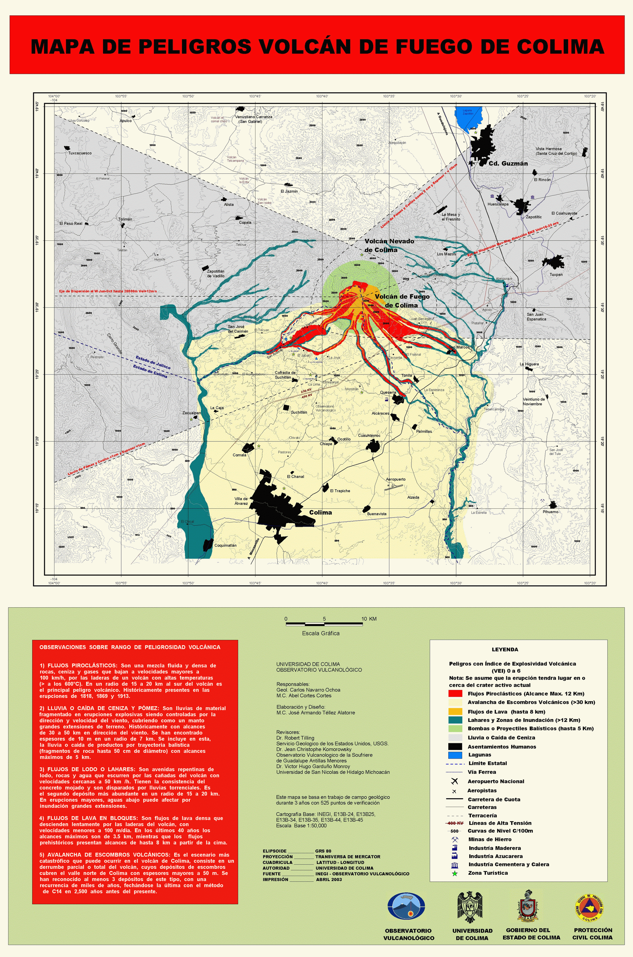
On the other hand, there is currently a publically available map that has served both as a reference and scientific foundation for decision making in terms of risk management. That map is the geological map mistakenly labelled as “Mapa de Peligros Volcán de Colima”, prepared by Navarro Ochoa and Cortés Cortés, and published in 2003 by the Universidad de Colima, in collaboration with the government of the State of Colima. In this map the geological fieldwork carried out by the authors during a three-year period with 525 field observation points is reflected. It includes zones where pyroclastic flows, debris avalanches, lava flows, lahars, and ballistic projectiles were mapped, as well as ashfall. Human settlements, water bodies, and roads are also indicated on the map (see Fig. 2).

Source Navarro and Cortés (2003)
Hazards map of Volcán de Colima. It is a map that summarizes the geological work carried out by researchers from the University of Colima. Although it has no data on impact probability and vulnerability factors, the map has been used for government decision-making. It possesses several problems, some of them technical, for example there are areas where the pyroclastic flows and lahares overlap, which does not allow clear distinction between them. Another problem is that the map is outdated, since its publication in 2003, it has not been updated, despite growth both in the population and agro-industrial activities in the vicinity of Volcán de Colima.
The cartographical information contained in this map denotes it a geological map. In order to be considered a hazard map, it would have to provide information regarding probability of recurrence and impact of each episode of volcanic activity. To be considered a risk map it would have to feature information on conditions of vulnerability for human settlements with regards to volcanic activity.
As previously mentioned, the map illustrated as Fig. 2 has served as a scientific reference for decision making regarding volcanic risk management. An example of the latter is the decree that declares La Yerbabuena as a settlement at high volcanic risk, made acknowledgeable to the general public on 24 May 2003 by the state government of Colima. The first article of this decree states the following:
The settlement of La Yerbabuena…is declared as being at high risk, for being within a range of 8 kilometres from the summit of the volcano, a distance at which that settlement is vulnerable to at least 3 types of volcanic hazards, which have been present in previous eruptions in the area, as shown in the hazard map of the Volcán de Fuego de Colima.
Despite being published a year after relocation of the settlement’s inhabitants, it has provided legal support during a series of social-political and legal conflicts, generated and aggravated by the relocation project. This will be explained later in the mitigation phase section.
Let’s keep in mind that human relocations have to be considered as the very last choice when it comes to mitigation and prevention of risk, due to the considerable social, economic, cultural, and political costs that those processes entail. For further information on the consequences of the relocation project, please review Cuevas and Seefoó (2005) and Macías (2001).
It has to be mentioned that some research has been dedicated towards producing volcanic hazard maps, and such maps were published prior to the one produced by Navarro and Cortés. Nevertheless, none of those other publications have been regarded as official pieces of cartography that can serve as a replacement for, or complement to the map produced by Navarro and Cortés (i.e. Martin del Pozzo et al. 1996; Capra et al. 2015). On the other hand, it is well known that risk and hazard maps have to be updated frequently, or every time that there is an eruption that modifies the relief around the volcano (Guevara et al. 2004). In the case of Volcán de Colima, this happened in July 2015 (Capra et al. 2016; Reyes-Dávila et al. 2016). Therefore, it is vital that recent hazards zoning works (i.e. Capra et al. 2015) be considered by the civil protection authorities, in order to update volcanic hazards maps. Meanwhile the official release of the Atlas Estatal de Riesgos is still awaited. It includes a series of maps on different volcanic hazards and risks by taking into account the probability of impact derived from different eruption scenarios as well as social, economic, and natural variables and indicators related to the vulnerability of several settlements within the state of Colima (see Fig. 3). Without a doubt, such an Atlas is going to be very helpful for the local authorities, because it dynamically integrates updated and relevant information on the conditions of risk of Colima’s risk-affected population, all of which will allow better decision making to be carried out towards mitigation of volcanic risk in the short, mid, and long term.

Source Varley et al. (2017)
Risk map associated with a VEI 4 eruption. This map is the result of a combination of hazard data with some elements of social vulnerability. This type of map allows better decisions to be made in the development of a volcanic risk management strategy.
Finally, it is worth pointing out that several aspects of the atlas risk analysis still have to be improved, because only a few vulnerability components, indicators and variables were studied for a few settlements, due to insufficient data and time to do fieldwork (Varley, personal communication). These limitations of the atlas risk analysis, constitute a barrier preventing an appropriate critical understanding of the real dimension of vulnerability (considering that alternative approaches are possible, other than numerical statistics and indicators). However, the work done on the atlas can be considered a big step forward for risk management. A start has been made to the study of risk, with the publication of an official risk map that includes important indicators of vulnerability, and not only geological and natural hazard cartography.
3.1.2 Monitoring the Volcano
Volcano monitoring is generally done by means of various disciplines, of which the most common are seismology, ground deformation and gas geochemistry (Donovan et al. 2012). Volcano monitoring in Colima is conducted mainly by an entity commonly and incorrectly known as “Observatorio Vulcanológico” (it cannot be considered as an observatory because the monitoring is not continuous, 24 h per day) officially named Centro Universitario de Estudios e Investigaciones de Vulcanología, CUEIV or University Centre for Study and Research in Volcanology, and the Faculty of Science of the University of Colima. Most seismic records from the seismologic telemetric network of the state of Colima, or RESCO, are received in the facilities of the civil protection authorities. The seismic data is obtained and processed, however, by the staff of RESCO with the goal of maintaining a monitoring capability (see Fig. 4).

State unit for Civil Protection’s communication centre. Real time seismic volcanic data can be observed on the lower and central screens. In theory, this centre functions as a monitoring and communication station for natural phenomena and the associated risk that occurs in the state of Colima. However, like the CUEIV, there are only staff during office hours. During times of crisis additional volunteer staff are brought into handle telephone and radio calls outside regular hours
Seismic monitoring of activity can therefore be carried out from Civil Protection’s offices in Colima, however, the training that operatives have received is minimal so any interpretation will highly limited, making critical decision making difficult, if not impossible. This came to light during the second evacuation caused by a volcanic crisis in July 2015. The director of CUEIV and RESCO was unavailable and since that monitoring group has no continuous coverage or established communication protocol, the General Director of the state unit of Civil Protection was requested to provide an interpretation of the seismicity by the government communication centre (CECOM). The urgency of the situation resulted in Civil Protection having to make decisions regarding evacuation, without a high level of certainty concerning the current state of volcanic activity.
The aim of the CUEIV is to monitor Volcán de Colima’s eruptive activity, to conduct scientific research within the state’s volcanic region, to coordinate the various groups of researchers working on aspects of volcanology, produce volcanic risk maps and strategize on disaster prevention in cooperation with both the state’s Civil Protection system and with CENAPRED (Centro Nacional de Prevención de Disastres or National Centre for the Prevention of Disasters). In addition, they prepare documents with which to publicize technological and scientific development in Earth Sciences including in social media, organize local conferences and debates, etc. Monitoring is carried out with the participation of volcanologists from the Faculty of Science (see Varley, this volume for details on monitoring instrumentation).
Regarding the first goal, monitoring volcanic eruptions, it is important to point out that, despite actions taken and data produced since 1994, the centre has been faced with a series of problems that go beyond its scientific responsibility. Political changes have had an impact, as well as the economic consequences of the constant reduction or cancelation of financial resources destined to develop and maintain consistent and precise volcanic monitoring. The scarcity of funds means fewer staff available to achieve constant monitoring 24/7. Therefore, staff work only during normal business hours, although during critical times they have had to organize 24-h vigilance and continued monitoring from the university’s facilities or from their own homes. Concerning the goal of consolidating a homogeneous group, with a clear objective of performing monitoring tasks, it has become necessary to strengthen bonds within CUEIV and being more open to welcoming researchers hailing from outside. In the case of the previous Scientific Assessment Committee and the current so-called Subcommittee of Geological Phenomena (see Sects. 3.2.1 and 3.2.2), less biased and more inclusive coordination is necessary on the side of Colima state’s Civil Protection authorities to include, for example, social and behavioural science disciplines. From the viewpoint of this research, to successfully reduce volcanic risk, more synergy is required.
3.2 Prevention
Prevention is defined in the Ley General de Protección Civil as the set of actions and mechanisms implemented prior to the onset of a hazardous phenomenon, with the objective of obtaining knowledge on the hazards or risk: identifying them, subduing them, or eliminating them; to prevent or mitigate their destructive influence on people, economic goods, or infrastructure, and to be able to foresee and anticipate the processes of social construction of risk. It is important to outline that risk and disaster, being social processes, imply a complexity that is inherent to the classification of courses of action within the process itself. Limits need to be clearly defined so that the risk zoning, mapping, and monitoring mentioned above also form a part of prevention actions being undertaken in Colima to achieve successful volcanic risk management.
One of the most important steps taken towards volcanic risk management has been the joint work of scientists and the official authorities. Relationships between these two social actors, for instance, resulted in the creation of agreements with the University of Colima’s scientific community to form a commission of expert volcanologists, replacing the now defunct Scientific Assessment Committee, with the Subcommittee of Geological Phenomena.
3.2.1 The Scientific Assessment Committee
The Scientific Committee for Risk Assessment was formed in 1998, starting with the signing of an agreement for cooperation between scientists and Colima’s state civil protection system, in order to consolidate seismological and volcanic monitoring (Manual of Operational Proceedings in Case of Emergency, section dedicated to mitigation of volcanic risk). Scientific Assessment Committee refers to a group of professionals committed to the study of any kind of hazardous natural phenomena, and who possess the technical and scientific skills to be able to understand the source, evolution, and potential consequences of such phenomena (2nd Article, agreement by which Scientific Assessment Committees of the National System for Civil Protection are defined as technical consulting bodies in the matter of the prevention of disasters originated by geological, meteorological, chemical, sanitary, or social-organizational phenomena; Diario Oficial de la Federación the official Government document, published on 6 June 1995).
In the case of the state of Colima, the technical scientific committee is defined by the Law of Civil Protection, decree no. 376, as the “technical consultant group for Civil Protection for integrated risk management at state level” (4th Article, Agreement by which the Scientific Assessment Committees of the National System for Civil Protection are established for the prevention of disasters, DOF, 6 June 1995). This committee consisted mainly of earth science experts and for a limited period, a few social scientists, the latter component setting it apart from the Scientific Committee from CENAPRED, which was constituted after the volcanic crisis caused by Popocatépetl in 1994 (Macías 1999).
The Committee’s functions were to establish a typological classification of potential crisis-causing phenomena for Volcán de Colima; evaluation of the data obtained from the volcano’s monitoring networks in order to carry out a forecast of the most probable eruptive scenarios, and their consequences for Civil Protection; establish a methodology to maintain observation and follow up on eventual volcanic eruptive events; to assess the information obtained in the case of the occurrence of these kinds of events, and finally, formulate advice to the authorities about how to intervene in order to reduce risk linked to volcanic eruptions (Manual of Operational Proceedings in Case of Emergency (section dedicated to mitigation of volcanic risk), State System for Civil Protection, Colima).
The Committee would convene at least once monthly, or more frequently whenever existing volcanic risk conditions warranted. Each session of the Committee was organized in the following manner: list of attendees, analysis on monitoring parameters, consensus, recommendations, general affairs, moderators’ signatures, meeting minutes, and bulletin.
Starting in July 2011, a new body was created to provide technical support to the State’s Civil Protection System: the Scientific Assessment Committee was terminated and replaced by a new Technical Scientific Assessment Committee on Natural and Man-made Hazardous Phenomena. This new committee was formed by specialists in all five major categories of risk that exist in the state of Colima: geological, sanitary, chemical, social-organizational, and meteorological. In the case of geological phenomena, a geologist was appointed, who in turn gathered other specialists to form the subcommittee for geological phenomena.
It is important to indicate that the Operational Director of the State Unit of Civil Protection and the spokesman for the subcommittee for geological phenomena stated that the emergence of this new technical body was the result of a change in the law on civil protection (personal communication on 21 November 2014 and 4 August 2015, respectively). However, it has not been possible to track that particular reform in the context of the Ley General de Protección Civil, the Ley Estatal de Protección Civil, the Manual of Organizational Operations within the Sistema Nacional de Protección Civil, or in the Decree by which the Scientific Assessment Committees of the Sistema Nacional de Protección Civil were created.
3.2.2 Subcommittee of Geological Phenomena
It is worth outlining that the now-defunct Scientific Assessment Committee for Volcán de Colima was a large group of specialists in Earth Sciences from both Colima and Jalisco, with frequent participation from external researchers and advisors at the national and international level. The group who took up the task of evaluating the development of volcanic activity sometimes numbered more than 20 people. It was a group specifically formed to conduct analysis on the volcano. In contrast, the current Scientific Assessment Committee for Natural and Man-made Hazardous Phenomena is made up of a number of different scientists specializing in each individual hazard area. The Subcommittee for Geological Phenomena is formed by a group of only six specialists in Earth Sciences and volcanologists from the University of Colima, and excludes specialists located in Jalisco, though they have continued to participate in sessions held with Civil Protection authorities at the national level to evaluate activity during times of crisis.
This new technical Subcommittee for Geological Phenomena, although different from its predecessor in terms of structure and number of members, is essentially in charge of the same functions as was the former Scientific Assessment Committee. The main difference in structure of the subcommittee is its tendency to being more exclusive towards other researchers, whether from the University of Colima or external, for example from the University of Guadalajara (capital of Jalisco).
Until now, it is unknown whether there is document where the functions and attributions of the old Scientific Assessment Committee were described in detail. Written protocols are increasingly necessary in order to avoid poor decisions that can result from a lack of experience, for example, decisions on social matters being made by volcanologists in the midst of a future volcanic crisis (they may find themselves in a position where they are compromised to make such decisions). This has been the case when populations have to be evacuated, however, that is an action that the Civil Protection authorities are responsible for taking.
In this regard, Donovan et al. (2012) point out that the gap between risk assessment and risk management is generally complex, especially when the boundaries of the various actors are unclear. This can be dangerous especially during volcanic crisis situations, where scientists, officials and the public are not properly prepared and decisions have to be made under high levels of uncertainty in both volcanic risk assessment and decision-making. Therefore, it is suggested that social scientific analysis within the generation of scientific advice could facilitate its development by framing it within the political context in which it is carried out.
3.3 Mitigation
Mitigation refers to actions whose goal is to diminish the impact or damage caused by the presence or occurrence of hazards. In this sense, many stages of the disaster process and hence risk are directly related to effective mitigation.
3.3.1 Relocation of People as a Means of Risk Mitigation and Disaster Prevention
The relocation of human settlements involves extremely complex processes that go far beyond the mere displacement and reestablishment of human populations and the solution of their housing needs, which is why it must always be planned and executed with the active participation of the affected population involved, and according to their actual needs. Otherwise the social, economic, cultural, political, and environmental costs may be unnecessarily high (Barabás and Bartolomé 1992; Cernea 1995, 1997; Macías 2001, 2009; Oliver-Smith 2001). There are five main factors to be taken into account to ensure the success of relocation projects. These include the participation of the population that is to be relocated during the entirety of the process (even for making the decision of whether or not to relocate), their involvement in designing new housing (Macías 2001), physical and geographical aspects of the new settlement, and the possibilities of achieving the anticipated levels of social and economic development (Coburn et al. 2009; Macías 2009).
The case of relocation of the settlement of La Yerbabuena was a crucial action for risk management in terms of social, political, and scientific issues. In 1999, the Scientific Assessment Committee declared the need for La Yerbabuena to relocate after a series of evacuations in the prior months (Cuevas and Seefoó 2005; Macías 2001; decree by which the settlement of La Yerbabuena is declared as a high-risk area). The relocation of many of the people of La Yerbabuena generated conflicts and aggravated pre-existing ones. Some people chose to remain in the established settlement rather than relocate, and the resulting conflicts of interest produced disruption of the community’s inner organization. The disruption was perceived by all the people involved (i.e. both the relocated people and those who chose to stay). For example, relationships between the inhabitants who refused to be relocated and the local government, especially the Civil Protection authorities, became problematic once cooperation on risk management between the two parties broke down.
The 57 relocated families were forced to adapt to a new environment, which was very different from the traditional lifestyles that they had in La Yerbabuena, and the 7 families that decided to resist relocation were forced by circumstance to commence new cultural and productive activities. They also had to implement a series of resistance strategies to make a living and fend for themselves in the context of new social dynamics, and on the other hand, to resist what they considered a flagrant violation of their human and individual rights. They believed that the claims by the authorities of the existence of volcanic risk were merely an excuse for the evacuation and relocation rather than a justification for it. To learn more on the complexity of this process, review the 2005 article (Cuevas and Seefoó).
It is important to mention that some volcanologists of the former Scientific Assessment Committee have insisted that they never participated in the formulation of the advice to relocate the settlement, which is at odds with the official version, indicated in the above-mentioned risk zone decree. Such ambiguity concerning an action of the magnitude of the relocation of a human settlement highlights the need for adequate and detailed ruling on the functions and responsibilities that scientific committees and subcommittees have in terms of risk management. As mentioned, they are mostly or entirely formed by earth-scientists with little or a total absence of both knowledge and skills in social research and hence, a very poor understanding of the causes and consequences of a variety of social phenomena relevant in actions such as evacuations and permanent relocations.
3.3.2 Volcanic Alert Systems
The objective of volcanic risk communication is to educate and to promote behaviour aimed at mitigating the risk. To do this it is necessary to link risk management and risk communication with a more inclusive approach, involving all stakeholders with robust methods that allow dialogue between the community, authorities and scientists at various levels (Barclay et al. 2008).
In Mexico, an instrument of communication and alertness, generically known as the Volcanic Warning Semaphore for Popocatépetl, has been developed. In the case of Colima, the Manual of Operational Proceedings in case of Emergency, in its section regarding volcanic risk mitigation, states that the traffic light warning system of Volcán de Colima is the mechanism of the state organization of Civil Protection, that keeps the people informed about the different levels of threat posed by volcanic activity. It also establishes that the alert system serves as a means to protect the families and the community as a whole. Each of its colours serves as an indicator of the particular level of danger present in a certain moment, and it is a reminder of things to be done as a consequence. The current Subcommittee for Geological Phenomena and Civil Protection authorities are the entities in charge of determining what colour the traffic lights should display within each community.
No physical device, such as a traffic light, has been installed in front of each vulnerable community to display colour signals in the state of Colima. Instead, the current alert or colour status has appeared in some press reports. The traffic light is an analogy that represents the level of danger and explains the actions that should be taken. In contrast to the situation at Colima, the volcanic traffic light of Jalisco does exist in each community as an actual device, and displays coloured signals to the local population (see Fig. 5). However, it is known that scientists from the University of Colima are currently collaborating with the Civil Protection authorities, in the design of a new volcanic alert system.

Volcanic alert system or “traffic light” in the community of Juan Barragán, Jalisco. The device indicates the state of volcanic activity and courses of action associated with the three colours: green, yellow and red. They also present a sketch of the evacuation routes to be followed by the various communities
The aforementioned manual states that the volcanic alert system is the last link in the information chain (but not the communication chain) between the authorities and the people. In other words, out of an entire chain of processes, the traffic light’s red light ends up being the means by which information resulting from the risk analysis, previously performed by the government and the scientific community, is given to the public, as well as the actions that must be taken as indicated in Fig. 6.

Source Reproduction of the outline contained in the “Manual of Operational Proceedings in the Case of Emergency”. Source Manual of operational proceedings in the case of emergency
Information flow and decision making for the volcanic alert system. In the scheme it can be seen that the alert system is considered the only mechanism for informing the population, that is to say, there is no further interaction between scientists, government authorities and Civil Protection and the population. The problem is that up to now in Colima, this alert system has not existed physically as an information mechanism. It is only referenced in the procedural manuals, which are not accessible to the public.
Figure 6 shows the simple and linear model of decision-making and risk management with which Civil Protection in the state of Jalisco acts. The population is considered as the last “link” in the “chain” of command, whereby they are represented as a passive group that only receives information, orders and is subject to government intervention.
As for the colours shown by the traffic light, the colour green indicates that normal, everyday activities can continue. Nevertheless, they ask the population to learn the different routes for emergency evacuation, to be aware of where meeting points determined by the authorities are located, attend training courses offered by Civil Protection units, partake in drills practiced in their communities, and remember that housing built on slopes and riverbanks is much more prone to be damaged, due to the fact that they represent the most common paths for volcanic material. Lastly, people have been asked to be aware of the benefits of building their houses with strong and preferably steep sloping roofs, in order to make them less vulnerable to ashfall (Manual of Operational Proceedings in case of Emergency).
The yellow colour means that people should be in a state of alert, pay close attention to what authorities declare through the media, and to actually follow the directions given. The authorities also recommend that families be prepared with individual cards indicating their names and addresses; close and shut down electricity, water and gas services in homes; to store drinkable water, food and medicine, as well as the most important documents such as property titles, birth and marriage certificates, military service carnets, etc.; to have a radio with charged batteries, a lantern, and house keys; and to cover water and food storage areas to prevent contamination by ash. Additionally, if they own cattle or other animals, they are asked to make an enquiry to Civil Protection officials on how to best protect them.
The red colour indicates alarm. When the signal is red, people must follow directions provided by authorities as a mandatory procedure. If they order an evacuation, people must gather together with their family members, have everyone properly identified, make sure that all doors and windows are closed, and before leaving, extend a white sheet or blanket in front of their houses to signal that their home is evacuated. They are then asked to immediately evacuate to meeting centres, taking with them only the essential items as listed in the previous paragraph. If possible, they are asked to evacuate diligently and without waiting for orders to be given; to reach the temporary shelter and take the place indicated to them. If medical attention is required, they must attend the closest healthcare facility. Once in the temporary shelter, they are asked to cooperate with whatever tasks they are assigned, to keep open communication with the authorities during their occupancy of the shelter and to pay attention regarding any developments related to the emergency until its end. If they are unable to locate the meeting centre, or if a means of transportation out of the danger zone is unavailable, they are asked to walk away from the volcano using the highest paths available to a safer place.
The intention is that both the current volcanic activity and the related risk assessments made by scientists are communicated through the analogy with the traffic lights, the aim being that the population take the appropriate protection measures. However, with a device such as the traffic light, at best, it serves to inform people but it is not a system that allows communication as such. It has been documented that increased awareness of hazards and knowledge related to the phenomena within the population does not necessarily lead to actions to reduce risks (Barclay et al. 2008).
Therefore, the incorporation of social scientists in the design and implementation of risk communication programs is necessary, to ensure that it is both appropriate and efficient. It is important that any alert system considers the communication and information needs of the populations at risk. Effective communication of volcanic risk needs to account for the socioeconomic situation of the population (Barclay et al. 2008), but must also include the socioeconomic and political conditions of the governmental authorities responsible for risk management.
3.3.3 Evacuation Routes
Considering the evacuation routes, distances between settlements and the most important road junctions have been calculated. Distances from La Yerbabuena on the evacuation route to La María is 3 km; and to the crossroads with La Becerrera it is 4 km; from there to El Cordobán bridge it is 4 km, and so on.
Some sections of the main evacuation route get blocked frequently, especially during the rainy season, and two particularly critical locations for hazards lie between El Cordobán bridge and La Becerrera and the junction to Carrizalillos, due to rockfalls and landslides in the area. This was clear during the passing of hurricane Jova in 2011, when La Becerrera and La Yerbabuena remained isolated for almost a week due to the roads being blocked. More recently, in 2015, after the impact of hurricane Patricia, the evacuation route that crosses El Zarco and El Cordobán bridges sustained damage and became unusable, as was the case with the road from La Becerrera to San José del Carmen, Jalisco, due to lahars and the rising of the river level (see Fig. 7).

Evacuation route damaged by a lahar. The community of La Becerrera, Colima, is surrounded by La Lumbre, El Zarco and El Cordobán rivers, which experience lahars during almost every intense rainfall event, with some of them affecting the communication routes. The image shows a road that serves as an evacuation route and the damage sustained due to a series of lahars produced in El Zarco ravine during the impact of Hurricane Patricia in October 2015. The lahars within La Lumbre also damaged the road considerably, leaving La Becerrera cut-off from both Colima and Jalisco
Lastly, it is important to point out the fact that there are alternative routes of evacuation out of La Yerbabuena that have been defined by those villagers resisting the relocations. Those routes are different from the officially established ones in that, according to those people, the official routes pass closer to areas that could be affected by volcanic hazards (see Fig. 8). It is clear that a constant re-evaluation of the evacuation routes and their condition is necessary. This should be carried out jointly between scientists, civil protection and the population at risk. The improvement of these emergency routes, as well as the involvement of the population in their design and maintenance, would be a good mechanism to ensure their official recognition and appropriate use.

Source Colima State Civil Protection
Evacuation routes in the state of Colima. This leaflet was prepared by the University of Colima and Civil Protection Colima, and shows the evacuation routes in case of a volcanic emergency. Also the most relevant communities and the distances between them and the crater of Volcán de Colima are shown.
3.4 Preparation and Aid
3.4.1 Preparation
Preparation is defined as all the actions and measures implemented in advance to ensure a more effective response to the impact of a hazard in the short-, mid-, and long-term. As was already mentioned, most actions undertaken by the Civil Protection authorities can be classified in more than one stage or phase within the disaster process. In this sense, it can also be said that all of the aforementioned actions such as establishing evacuation routes, volcano alert system and relocation are part of the stage of preparation.
A clear example is the creation of manuals and emergency protocols described in previous sections of this chapter. Their contents and organizational charts are described below.
3.4.1.1 Manual of Procedures and Protocols in Case of Volcanic Emergency
As it has been explained, in the particular case of the state of Colima there is a series of official measures intended to achieve efficient management of volcanic risk. Large part of such measures are detailed in the Manual of Organization and Operation ‘Volcán de Colima, as well as in the Manual of Operational Proceedings in the Case of Emergency, the latter including a section that addresses mitigation of volcanic risk.
In the Manual of Organization and Operation ‘Colima Volcano, a twelve-page booklet, a variety of topics are briefly addressed such as: general aspects of the volcano (mainly its physical and geographical features), the populations at risk, risk zoning and classification, parameters for volcano monitoring, the evacuation route map (for the settlements of Colima, Comala and Cuauhtémoc), details of communication options (radio and telephone lines), an information bulletin (resulting from sessions held by the now defunct Scientific Assessment Committee), an estimation on the number of inhabitants at risk due to volcanic activity, the location of a service centre for the people affected, and a definition of the governmental dependencies that participate in the Operational Plan for evacuation of high risk settlements. Included are the activities that each of those entities is expected to perform.
The Manual of Operational Proceedings in the Case of Emergency, which includes a section dedicated to the mitigation of volcanic risk, contains a subsection which includes a definition of risk and ways to reduce it, through what is conceptually referred to as active protection. It also contains a subsection dedicated to explaining how volcano monitoring in Colima is performed. Other subsections feature digital maps that present potential risk scenarios; one presents the map of volcanic hazard by Navarro and Cortés (2003). A description of the “volcano observatory” (CUEIV) and the Scientific Assessment Committee and its role within the State System of Civil Protection are also described. Lastly, a subsection summarises how ordinary and extraordinary sessions of the committee were held, the flow of information in the case of an emergency related to the volcano, the volcanic alert system, and evacuation routes.
It is necessary to emphasize that these documents are not available for the general public, they are kept in the offices of Civil Protection. These documents are not updated, and have not yet been approved by Colima’s elected governor, who according to the law, is the President of the State System for Civil Protection. These documents were developed based on the general outlines of the Volcanic Emergency Management manual of the United Nations Disaster Relief Office (UNDRO 1985), which gives us an idea of the implications of these international schemes, for example, schemes were created based on the experience gained in developed countries and therefore are not fully applicable in so-called third world countries. In that sense, successful transfer of technology proposed by the UNDRO model requires special attention to community livelihoods, especially economic, family, social and cultural subsystems. Likewise, the UNDRO model needs to evolve to make disaster mitigation the responsibility of the people of these communities working hand-in-hand with local emergency management agencies, informed public officials and scientific groups (Macías and Aguirre 2006).
It is important to note that neither of the two manuals of operational procedures (OOVC Manual or OPCE) establish the criteria or the basis on which a decision is taken to move from one alert phase to another, nor do they establish the parameters and criteria for deciding on an evacuation or relocation of a population at risk, nor who determines such decisions. These criteria should be developed and established with the full participation of the at-risk population.
3.4.2 Aid
The stage of aid is defined as the response directed to the people at risk, or affected by a emergency or disaster, and provided by public or private specialized working teams, or by units of Civil Protection, as well as all actions intended to defend any other risk-prone populations.
In Colima, in the case of volcanic risk, the aid phase is implemented when the Subcommittee of Geological Phenomena identifies a significant increase in volcanic activity that, because of its nature and dimensions, could affect certain human settlements; after that, they discuss with the State unit of Civil Protection the evaluation of the situation and any decision on which actions shall be taken. In the case of evacuations or any other specific orders, the Civil Protection authorities at the state level report to upper governmental entities via radio and telephone. The municipal commissioner in charge of the settlement to be evacuated is advised via radio, so he and his support team can distribute the information using loud speakers or by going door-to-door. Transport is prepared to assist in the evacuation. The inhabitants are placed together in public parks and then transferred with use of public transportation (see Fig. 9). A preliminary count of the evacuated population is done during their transportation, and then again when they arrive at the shelters.

People assembled in a public park in La Becerrera, before being evacuated in September 2016. The photograph shows the moment in which the people of the community were gathered in the main garden to receive indications from the Director General of Colima State Civil Protection (person with orange vest), before being evacuated in anticipation of the increase in volcanic activity
It is important to note that the decision-making process is inherently multidisciplinary, for example a particular expertise is required so that consideration can be given to the way in which people are informed about volcanic hazards. This is an aspect in which social scientists and communication experts can play an extremely important role (Marzocchi et al. 2012).
During the volcanic eruptions of July 2015, evacuations were made once the pyroclastic flows were generated from the eruption, and once volcanic ash began to cover the populations of La Yerbabuena and La Becerrera. The evacuation of 10 July 2015 was made based on the decision taken only by the Operational Director of the State Unit of Civil Protection. The next day, the evacuation of 11 July was decided collectively between the Subcommittee on Geological Phenomena, Civil Protection officials and other government authorities. It is important to note that the two evacuations were reactive rather than preventive.
The Secretaría de la Defensa National (Ministry of Armed Forces, SEDENA) and local councils take care of preparing, managing, and operating the temporary shelters. Public security personnel at both the state and local level support the evacuation processes and guard the perimeters of the evacuated areas. The Secretaría de Salud (Ministry of Health) is responsible for performing check-ups of the evacuated people. There is a long list of other governmental institutions that partake in this operational plan, which includes the Dirección de Transportes (Department of Transport), Comisión Nacional del Agua (National Water Commission), Desarrollo Integral Familiar (Department for Family Development), the Fire department, the Mexican Red Cross, Secretarìa de Administración del Gobierno del Estado (Department of Administration of the State Government), Procuraduría General de Justicia (Justice Department), Teléfonos de México (State Telephone Company), Secretaría de Comunicaciones y Transportes (Secretary of Communications and Transport), Desarrollo Urbano (Department of Urban Development), Rancho “El Jabalí” (a private entity), and groups of volunteers.
Although in Colima there is a list of participating institutions and government agencies in the event of a volcanic emergency, there is no established protocol to follow, i.e. the mechanisms by which the operational plan is implemented and the procedures by which each government agency is notified.
4 Conclusion
The understanding of volcanic risk must go beyond the probability of impact of volcanic hazards, and actions to reduce volcanic risk should not be based solely on the monitoring of the volcanic phenomenon. Many social, economic, political and cultural factors related to the populations at risk, civil protection personnel, scientists and other authorities should be considered in the design of strategies to manage and reduce volcanic risk. Otherwise, one only addresses part of the problem, rather than its complex entirety: in its construction as a process. To do this, the risk management strategy must be more socially engaging, through the integration of social scientists in its design and implementation, and with the total participation of the population in the process. In that sense, the relationship and interaction between scientists, Civil Protection and population must be much closer and more active. These aspects are detailed below with respect to each phase of Integral Risk Management.
For risk identification, maps of volcanic hazards should be regularly updated due to the constant changes in the environment, such as the volcano drainage pattern, due to the continuous eruptions and often intense rainy seasons, as well as the increase of agro-industrial activities in the volcanic zone and the increasing construction of ranches and country houses. Also worthy of note is the release of the State Risk Atlas, in the section on volcanic risk, where vulnerability maps were constructed by integrating some elements of social vulnerability with volcanic hazards. It is therefore suggested that such information be integrated into the design of the risk management strategy. With respect to monitoring, it is necessary to employ more personnel to enable 24 h a day, 365 days a year monitoring, or at the very least during moments of increased activity. The incorporation of university students as volunteers could be an alternative to achieve continuous monitoring.
With regard to prevention, the functions of the Subcommittee of Geological Phenomena should be established in detail, and social scientists should be involved in risk assessment and decision-making. It is important that actions to reduce risks should be carried out mainly in moments of volcanic calm, so that when the activity increases, populations, scientists and authorities are prepared.
In the mitigation phase, it is necessary to consider the political, scientific and social experiences acquired during the process of relocation of La Yerbabuena, since criticism has arisen due to the different perspectives of Civil Protection and social scientists, but relocation could be the only option for certain communities. In addition, new mechanisms for the reduction of volcanic risk must be sought with the full participation of the target populations. With regard to the volcanic alert system, a broader and more permanent volcanic risk communication program should be developed to increase the efficiency of the system currently under development. Alone it is not enough to ensure an appropriate self-protection reaction within the communities. The participation of social scientists will be of great importance to make any headway. Likewise, in this communication program, social mechanisms must be established so that communication is not unilateral: from Civil Protection to the population, but is multidirectional, in which the various social actors can communicate and express their needs and concerns, and that these are heard, understood and answered. Finally, evacuation routes should be re-evaluated and conditioned to make them more effective and to reduce the risk from other hazards during an eruption crisis.
For the preparation and assistance stages, the existing operational and manual plans with definitions of procedures must first be re-evaluated and updated. These documents are based on the general schemes of the Volcanic Emergency Manual prepared by the United Nations Disaster Relief Office (UNDRO), and they require further adaptation to the political, economic, scientific and social context of Mexico and in particular Colima. They should detail the roles and responsibilities of each social actor involved in risk management, and the capacities and resources available to deal with volcanic hazards. An adequate decision-making mechanism corresponding to the roles and responsibilities of each participant should be detailed. This will avoid conflicting situations, such as those experienced in the relocation of La Yerbabuena, and will allow actions to be more appropriate with respect to the target population. Later, the documents should be distributed to the population, with continued availability to the public and the research community.
These recommendations have the sole objective of creating a more social and therefore more adequate and effective volcanic risk management strategy.
References
Barabás, A., Bartolomé, A.: Antropología y relocalizaciones. Alteridades. Revista de Ciencias Sociales y Humanidades 2(4), 5–15 (1992)
Barclay, J., Haynes, K., Mitchell, T., Solana, C., Teeuw, R., Darnell, A., Crosweller, H., Cole, P., Pyle, D., Lowe, C., Fearnley, C., Kelman, I.: In Liverman, D., Pereira, C., Marker, B. (eds.) Communicating Environmental Geoscience. Geological Society, London, Publications, 305, pp. 163–177 (2008)
Capra, L., Gavilanes-Ruiz, J.C., Bonasia, R., Saucedo-Giron, R., Sulpizio, R.: Re-assessing volcanic hazard zonation of Volcán de Colima, México. Nat. Hazards 76, 1–21 (2015)
Capra, L., Macías, J., Cortés, A., Dávila, N., Saucedo, R., Osorio, S., Arce, J., Gavilanes, J., Corona, P., García, L., Sosa, G., Vázquez, R.: Preliminary report on the July 10–11, 2015 eruption at Volcán de Colima: pyroclastic density currents with exceptional runouts and volume. J. Volcanol. Geoth. Res. 310, 39–49 (2016)
Centro Universitario de Estudios e Investigaciones de Vulcanología (CUEIV). http://portal.ucol.mx/cueiv/. Consulted 15 Dec 2016
Cernea, M.: Primero la gente. Variables sociológicas en el desarrollo rural. Fondo de Cultura Económica, Mexico (1995)
Cernea, M.: The Risk and Reconstruction Model for the Resettling of Displaced Populations. World Bank, Washington DC (1997)
Coburn, A., Leslie, J., Tabban, A.: In: Macías, J.M., Investigación evaluativa de reubicaciones humanas por desastres en México, pp. 49–97. Centro de Investigaciones en Estudios Superiores en Antropología Social, Mexico (2009)
Cuevas, A.: (2005) Dinámicas de interfaces entre diversos actores sociales: Reubicación de una población campesina por un posible riesgo volcánico. Ph.D. thesis, El Colegio de Michoacán, Mexico
Cuevas, A., Seefoó, J.: Reubicación y desarticulación de La Yerbabuena; entre el riesgo volcánico y la vulnerabilidad política. Desacatos, Centro de Investigaciones en Estudios Superiores en Antropología Social, pp. 41–70, Sept–Dec, number 019 (2005)
Donovan, A., Oppenheimer, C., Bravo, M.: Science at the policy interface: volcano-monitoring technologies and volcanic hazard management. Bull. Volcanol. 74, 1005–1022 (2012)
Gavilanes, J.C.: Simulación de escenarios eruptivos del Volcán de Colima y aportaciones al plan de contingencias del estado de Colima. Masters thesis, Posgrado en Geografía de la Universidad Autónoma de México (2004)
Gavilanes, J., Cuevas, A., Varley, N., Gwynne, G., Stevenson, J., Saucedo, R., Pérez, A., Aboukhalil, M., Cortés, A.: Exploring the factors that influence the perception of risk: the case of Volcán de Colima, México. J. Volacanol. Geoth. Res. 186, 238–252 (2009)
González, L.: Evaluación de la vulnerabilidad social en la comunidad Ex-hacienda San Antonio, La Yerbabuena, Edo. de Colima. Undergraduate thesis, Facultad de Filosofía y Letras, Colegio de Geografía, Universidad Nacional Autónoma de México (2000)
Guevara, E., Quass, R., Fernández, G.: Guía Básica para la Elaboración de Atlas Estatales y Municipales de Peligros y Riesgos, p. 155. Centro Nacional de Prevención de Desastres, Mexico (2004)
INEGI: Censo de Población y Vivienda 2010. www.inegi.org.mx (2010)
Ley General de Protección Civil: Diario Oficial de la Federación 6 June 2012, with last amendments on 3 June 2014. https://www.gob.mx/indesol/documentos/ley-general-de-proteccion-civil-60762 (2012)
Luhr, J.F.: Petrology and geochemistry of the 1991 and 1998–1999 lava flows from Volcán de Colima, Mexico: implications for the end of the current eruptive cycle. J. Volcanol. Geoth. Res. 117(1–2), 169–194 (2002)
Macías, J.: Riesgo volcánico y evacuación como respuesta social en el Volcán de Fuego de Colima. Textos urgentes, Centro de Investigaciones y Estudios Superiores en Antropología Social y Universidad de Colima, México, pp. 87 (1999)
Macías, J.: Reubicación de comunidades humanas. Entre la producción y la reducción de desastres, p. 280. Universidad de Colima, Mexico (2001)
Macías, J.: Investigación evaluativa de reubicaciones humanas por desastre en México. Centro de Investigaciones y Estudios Superiores en Antropología Social, p. 614. México (2009)
Macías, J.: Los Modelos gubernamentales para enfrentar los problemas del riesgo-desastre (Defensa Civil, Protección Civil, Manejo de Emergencias). Texto elaborado para la Especialidad de Gestión Integral de Riesgo de Desastre en la Escuela de Administración Pública de la Ciudad de México: 1–71 (2016)
Macías, J., Aguirre, B.: A critical evaluation of the United Nations volcanic emergency management system: evidence from latin America. J. Int. Aff. Spring/Summer 59, 43–61 (2006)
Macías, J., Saucedo, R., Gavilanes, J., Varley, N., Velasco, S., Bursik, M., Vargas, V., Cortés, A.: Flujos piroclásticos asocidados a la actividad explosiva del Volcán de Colima y perspectivas futuras. GEOS 25(3), 340–351 (2006)
Martin del Pozzo, A., Sheridan, M., Barrera, D., Lugo, J., Vázquez, L.: Potential hazards from Colima Volcano, Mexico. Geofísica Internacional 34(4), 363–376 (1995)
Martin del Pozzo, A., Sheridan, M., Barrera, D., Lugo, J., Vázquez, L.: Mapa de Peligros Volcán de Colima. Instituto de Geofísica, Universidad Autónoma de México, Mexico (1996)
Marzocchi, W., Newhall, C., Woo, G.: The scientific management of volcanic crises. J. Volcanol. Geoth. Res. 247–248, 181–189 (2012)
Mendoza-Rosas, A.T., De la Cruz-Reyna, S.: A statistical method linking geological and historical eruption time series for volcanic hazard estimations: applications to active polygenetic volcanoes. J. Volcanol. Geoth. Res. 176(2), 277–290 (2008)
Navarro, C., Cortés, A.: Mapa de Peligros Volcán de Colima, Universidad de Colima, Mexico. http://portal.ucol.mx/content/micrositios/169/image/mapa.gif (2003)
Oliver-Smith, A.: Consideraciones teóricas y modelos del reasentamiento de comunidades. In: Macías, Reubicación de comunidades humanas. Entre la producción y la reducción de desastres. Universidad de Colima, Mexico (2001)
Reyes-Dávila, G.A., Arámbula-Mendoza, R., Espinasa-Pereña, R., Pankhurst, M.J., Navarro-Ochoa, C., Savov, I., Vargas-Bracamontes, D.M., Cortés-Cortés, A., Gutiérrez-Martínez, C., Valdés-González, C., Domínguez-Reyes, T., González-Amezcua, M., Martínez-Fierros, A., Ramírez-Vázquez, C.A., Cárdenas-González, L., Castañeda-Bastida, E., Vázquez Espinoza de los Monteros, D.M., Nieto-Torres, A., Campion, R., Courtois, L. Lee, P.D.: Volcán de Colima dome collapse of July, 2015 and associated pyroclastic density currents. J. Volcanol. Geoth. Res. 320, 100–106 (2016)
Saucedo, R., Macías, J., Sheridan, M., Bursik, M., Kmorowski, J.: Modeling of pyroclastic flows of Colima Volcano, Mexico: implications for hazard assessment. J. Volcanol. Geoth. Res. 139, 103–115 (2005)
Saucedo, R., Macías, J., Gavilanes, J., Arce, J., Komorowski, J., Gardner, J., Valdez, G.: Eyewitness, stratigraphy, chemistry, and eruptive dynamics of the 1913 Plinian eruption of Volcán de Colima, México. J. Volcanol. Geoth. Res. 191, 149–166 (2010)
Sheridan, M.F., Macías, J.-L.: Estimation of risk probability for gravity-driven pyroclastics flows at Volcan Colima, Mexico. J. Volcanol. Geoth. Res. 66(1–4), 251–256 (1995)
United Nations Disasters Relief: Volcanic Emergency Management, pp. 86. United Nations (1985)
Varley, N.: Evaluación del riesgo volcánico del Volcán de Colima, México. Presentado en el Foro Internacional sobre Gestión del Riesgo Geológico, Arequipa, Perú (Oct 2015)
Varley, N.R., Cernas, J.A., García, A., López, Z., Meza, M.I.: Riesgos Volcanológicos, Atlas de Riesgos Estatal de Colima, Universidad de Colima, Protección Civil del Estado de Colima, Colima (2017)
Suárez, C., Saavedra, G.: Análisis y mapa de riesgo del Volcán Colima, México. Centro de investigaciones de la Facultad de Geografía, Universidad de Guadalajara
Acknowledgements
I thank the reviewers Jesús Manuel Macías, Luisa Macedo Franco and Chris Gregg for their valuable contributions to the work. I also thank Nick Varley and Juan Carlos Gavilanes for their help in improving the document, and Graeme Alexander William Sinclair for his help in translation.
Author information
Authors and Affiliations
Corresponding author
Editor information
Editors and Affiliations
Rights and permissions
Copyright information
© 2019 Springer-Verlag GmbH Germany, part of Springer Nature
About this chapter

Cite this chapter
García, H.I.R. (2019). Civil Protection and Volcanic Risk Management in Colima. In: Varley, N., Connor, C., Komorowski, JC. (eds) Volcán de Colima. Active Volcanoes of the World. Springer, Berlin, Heidelberg. https://doi.org/10.1007/978-3-642-25911-1_10
Download citation
DOI: https://doi.org/10.1007/978-3-642-25911-1_10
Published:
Publisher Name: Springer, Berlin, Heidelberg
Print ISBN: 978-3-642-25910-4
Online ISBN: 978-3-642-25911-1
eBook Packages: Earth and Environmental ScienceEarth and Environmental Science (R0)