
Abstract
Water security concerns the sufficient availability of equitable access to water for humans and the ecosystem. Drylands are the worst geographical region affected by chronic seasonal drought and water crises due to their geo-climatic condition. Purulia district of West Bengal state in India has a long history of seasonal drought and summer water crisis which calls for some adaptive measures to sustain the water-secured future. The district has a unique identity with its significant concentration of indigenous communities who have been practicing different traditional resilient techniques to prevent the risk of water insecurity. This chapter highlights these traditional adaptive measures practiced by different indigenous communities in the district. Based on the secondary data sources and primary data collection through the focus group discussion (FGD) in different villages, we have thoroughly assessed the traditional water harvesting technologies for different purposes. This study also attempts to present the theoretical foundation of nature-based resource conservation and multi-level policy-driven approaches for securing water in the dry land rural setup. The result shows different levels of water harvesting systems in the district for multiple usages ranging from domestic usage to irrigation purposes on one side and the multiple government policy-driven approach on another for a secure water future for dry land rural development.
Access provided by Autonomous University of Puebla. Download chapter PDF
Keywords
1 Introduction
Water is a finite resource, and its availability varies regionally based on its geophysical, climatic, and socioeconomic status. The term water security (WS) implies two different aspects, one is water for human consumption and another is water for the environment. From the anthropocentric perspective, WS relies on affordable and equitable sharing of benefits for all, where no one is far behind in water utilization. WS for the environment means water competence to sustain the ecological system. WS has four components that combine water availability within a system, accessibility of water, water risk and hazard, and water management (Holmatov et al. 2017). Among the four components of WS, water availability is the primary integer that acts as a foundation for the remaining three components. Water availability denotes how much water is physically available within a system (Srinivasan et al. 2017). If it is scarce, then it usually creates a regional water crisis. Thus, WS is an umbrella term that combines water scarcity (lack of physical water availability) and water crisis (lack of water affordability). Water availability and accessibility become more critical in some fragile ecosystems, like dry land ecology (Bradford et al. 2020), which gets the direct negative consequences of global climate change (Lian et al. 2021). Throughout the globe, drylands are the most threatened ecology due to the factors like decreasing amount of rainfall (Sintayehu 2018), increasing temperature (Lian et al. 2021), deforestation (Leite-Filho et al. 2021), land degradation (Willemen et al. 2018) with wasteland formation (Kar et al. 2020) that also provides ample amount of risk for the local livelihood. More specifically, globe dry lands in Asia and Sub-Saharan Africa are worst affected by regional marginalization (Jobbins et al., 2018). About 2.3 billion people live in water-stressed countries, of which 733 million live in highly and critically water-stressed countries (UN-water 2021). It affects more than 40% of the global population (United Nations). Almost 80% or more of wastewater returns to the environment without adequate treatment (Jones et al. 2021). Even the concentration of indigenous communities is abundant in some dry land parts of the world (Feng et al. 2020). In order to sustain the economy and livelihood generation, most indigenous communities are practicing nature-based solutions to restore water and other associated resources (Vohland and Barry 2009; Binyam and Desale 2015; Ali 2016). The rural dry land setup needs to have proper water utilization where both water for irrigation and domestic utilization and water for ecology need to integrate with an optimum equilibrium state. Rural water security (RWS) in dry land comes with four major elements: domestic water utilization, water for irrigation, water for the ecosystem, and water risk and hazard (particularly drought). Water management gets the specific notation through water harvesting techniques (WHT), where water is collected from the runoff to surmount the deficiency and utilize it in multiple ways (Beckers et al. 2013). The primary nature of WH is more interlink with the land–water nexus. However, some of the other factors within a system determine the efficiency of WHTs. These Major sub-entities include geophysical factors like rainfall, potential evapotranspiration, slope, rock structure, and catchment character. Apart from the geophysical and climatic conditions in a region, the sustainable WHT need to be assigned to environmental, economic, and social aspects. The dry lands are one of the geographical sets known for their aboriginal concentration; thus, the region-specific uniqueness of WH is also common. In this regard, the term indigenous knowledge (IK) and traditional knowledge (TK) is synonyms for each other, where both are assigned with long historical interactions between the man-environment that help to build certain knowledge (Das et al. 2022). TK is the idea, skills, and practices that are inherited from one generation to another whereas IK is the subset of TK commonly developed and practiced by a particular indigenous community considering the natural environment, which is sometimes inseparable from their traditional cultural values and spiritual beliefs (Gunara et al. 2019). The main positive features of indigenous TK are as follows: (1) cost-effectiveness, (2) providing long-term solutions, and (3) nature-based or less or no damage prone to the natural ecosystem. Among the different forms of water resources like surface water, atmospheric water, and groundwater, the traditional WHTs show different global imprints. Study shows that wide-ranging traditional WHTs are being applied in areas where annual precipitation is between 100and 1500 mm and a population density of about 10–500 per km2 (Melkania 2008). But, another group of scholars has shown that the WHTs are predominant in those regions where the annual rainfall is between 100 and 700 mm (Tumbo et al. 2013; Lebel et al. 2009). In some cases, although the region receives adequate rainfall, the adjacent topographic characteristics cause low groundwater recharge and high surface runoff. For instance, parts of the Chota Nagpur plateau in India are composed of hard rock terrain that causes high surface runoff and shallow groundwater tables (Kar et al. 2020). In Gujarat state (particularly in the Amreli district), hard rocky terrain is not capable of rainwater harvesting. Hence, the construction of check dams and percolation tanks is acceptable with a regional geophysical setup (Soni 2006; Hardiman 1998). Among the different types of WHTs, some of the specific traditional methods adapted to dryland environments, like collecting surface runoff through rill and slope (Strohmeier et al. 2021), harvesting flood water (Prinz and Singh 2000), tank system (Bitterman et al. 2016), rainwater reservoir (Beckers et al. 2013), human-made cave system to restore water (Prinz and Singh 2000), groundwater dams (Oweis and Hachem 2006), rooftop WHT (Tamaddun et al. 2018), and inter-row WHT (Prinz 1996), are predominant within WHT. Although, each of the specific WHTs fulfills a particular aspect of water security. For example, rooftop WHT is particularly applied to fulfill household water demand (Adugna et al. 2018; Alim et al. 2020). The inter-row WHT is applied to fill the irrigational water demand for crop production (Zhang et al. 2022). The rainwater harvesting system through silt traps in Australia is applied to fulfill water demand for animals (Lakel III et al. 2010). Apart from the fulfillment of human water demand, some tools of WHT are applied for human–environment water demand. For example, a micro-catchment system to support the annual crop production will also tackle soil erosion (Kurothe et al. 2014). In some cases, rainwater reservoirs in Northern Vietnam are used for paddy cultivation and become an effective human-made tool to control soil erosion, prevent floods and recharge the groundwater. A wider set of academic literature has considered the positive and sustainable relationship between traditional practices for the conservation of the environment. However, apart from the positive relationship between traditional practices and the environment, some regional economic practices hampered environmental sustainability. Apart from the different sets of traditional WHTs applied in different geographical setups, there are few contemporary methods practiced by indigenous society. For example, restoring the ‘marginal water’ becomes quite well applicable in certain regions of the globe. Collecting flood water and conserving fog and dew are considered ‘marginal water’ (Prinz 2002). The diversion of flood water from streams bed has been recognized as a possible cropping adjustment in Middle East and North African countries. Similarly, the collection of fog drip becomes effective for agriculture in the coastal zones of Chili, Peru, and Cape Verde (Fessehaye et al. 2014). Hence, considering all these above-mentioned aspects, this chapter tries to highlight dry land rural water security by applying different traditional WHT. For that, we have taken the Purulia district of West Bengal state, India, as a case study where we have tried to incorporate different sets of traditional indigenous methods to restore water for different utilization. Simultaneously, we have undertaken different government policies and suggested methods to conserve water for this dry land drought-prone area to achieve long-term rural water security.
1.1 Aim and Objectives
The present study highlights different WHTs practiced by dryland communities, particularly in rural settings. More exclusively, the chapter seeks to explore multiple WHTs where traditional knowledge is being implemented in the dry semi-humid region of West Bengal state. The following objectives are as follows:
-
i.
To address the meaning and implication of traditional knowledge (TK) to conserve environmental entities.
-
ii.
Highlight different traditional WHTs in different dry land setup across the globe.
-
iii.
To conserve water in the dry land of West Bengal, with particular reference to rural setup.
2 Methodology
The chapter aims to highlight the traditional water harvesting methods in dryland systems, which drives us to manifest two different sets of knowledge production. The first one is to synthesize the nature of different traditional water harvesting methods in the dry land region across the world. The second one is to set out the practical illustration of some of the traditional water harvesting (WH) structures that try to secure RWS in the dry land area of West Bengal in India. Hence, the chapter undergoes two approaches parallel; the first is the theoretical foundation of traditional knowledge with its implication in dry land–water security, whereas the second is the case-specific study of the practical manifestation of some traditional water harvesting technologies that involve traditional local knowledge. Based on the two different sets of study, we have obtained multipurpose approaches ranging from narrative review for providing the theoretical base of the study, to purposive random sampling and focus group discussion (FGD) for the practical implication of the study. Figure 16.1 represents the flow chart of two different study sets, along with the multi-level assessment and data collection for the study.

Flowchart representing the multi-level of assessments and the data collection tools applied at each level
We have considered the narrative review approach of the study for obtaining rigorous knowledge synthesis on traditional knowledge (TK) and its implication on natural resource conservation. We have evaluated many empirical and conceptual papers on traditional knowledge, indigenous resource utilization, and the necessity to obtain traditional knowledge to conserve natural resources. The second stage of our literature review seeks to explore some examples of traditional water management systems in dryland areas of the globe. We have considered literature written in English published in different years across different disciplines (mainly Anthropology, Geography, Biology, and Environment History). In this stage of our analysis, we have specified different structures of water harvesting along with their categorization based on the nature of water harvesting, like surface water (SW), atmospheric water (AW), and groundwater (GW), description of the structure and purpose of utilization.
Based on the theoretical foundation from the first section, we have tried to evaluate field-based practical examples from the study area to obtain some of the specific traditional water harvesting structures. Keeping this in mind, we have taken the Purulia district, the dry land area in West Bengal state in India. Since it is an environmental anthropocentric approach where human society makes a complex relationship with their natural environment (Salick et al. 2020), we have considered the material observation method to know the explicit uses and background of different water harvesting structures. Since the district had its socialist and tribal rebellion movements in the past, therefore before choosing the blocks and villages, we thoroughly discussed with the government officials about the present socio-political condition of the villages, the communication network connection, and the feasibility of conducting the study. Keeping all the above-mentioned aspects in mind, we have selected a total of 9 villages from 8 g Panchayat (GP) of 5 different blocks (Table 16.1 and Fig. 16.2). Villages selected by random sampling have a significant concentration of indigenous communities. However, none of the villages is explicitly tribal villages, as our focus was to obtain the traditional WHT instead of identifying the tribal clan's specific WHT.

Village surveyed in the study area
We initiated our field visit in 2019 (January–February), and after two years of gap due to the pandemic, we resumed our field-based data collection in 2022 (June–August). Based on the pre-existing literature on traditional water harvesting methods in dryland areas in the Purulia district (Bauri et al. 2020; Oweis and Hachum 2009) and adjoining other parts of the district, we have prepared our conceptual foundation of different water harvesting structures. More importantly, we examined different WHTs based on a location-based community survey in each village. To identify different WHTs, we made a small group of each village to explore some of the different WH structures. Each WH structure differs based on its location, uses, and construction. Therefore, we framed a set of questions for each of the WHT, like the following: (1) the background of the structure, (2) specific utilization, (3) the type of ownership, and (4) who is maintaining the structures. We have gathered our primary data based on multi-level investigation and interviews. For example, in level 1, we select ten individual respondents for each individual WHT (n1 = 100 as 10 individual * 10 WH structures) to get the detailed information on different WHT. In level 2 of the field-based assessment, we interact with 36 GP heads (n2 = 36) through semi-structured interviews. After the community-based survey, he tried to intermingle with some government officials (level 3). For that, we conduct a brief interaction with a total of 19 official members (n3 = 19), like Block Development officers (BDO), official members of Water Resource Investigation and Development (Agri-irrigation campus of Belgium in Purulia-2 block), and civil engineers from the corporation office. The interaction with government officials was not only for gathering knowledge against the WHT adopted by the traditional society rather obtaining in detail information on different government policies like ‘Ushar Mukti,’ ‘Jal Dharo Jal Bharo,’ and ‘Jalatirtha,’ which are based on water resource management for the district.
3 Results and Discussions
The chapter has two major sections of the study; one is the theoretical base which includes the narrative of traditional knowledge (TK) with its applicability for resource conservation along with case-specific WHT in global dryland setup and another one is practical inferences of different WHTs for securing dryland RWS.
3.1 Traditional Knowledge and Its Applications for Environmental Conservation
In this chapter, the terms indigenous knowledge (IK), traditional knowledge (TK), and local knowledge (LK) are used interchangeably. People attached to a particular environment and depended on it to sustain their livelihood also accomplished some inherent knowledge from one generation to another. The TK or IK is not only some level of skill developed over a period within a particular geographical setup, rather it is being recognized as the social capital of the home-grown community (Islam 2013) and the community-level decision-making process to secure livelihood (Charles and Berkes 2021). Indigenous knowledge is dynamic and gets matures through the trial-and-error process. Therefore, the nourishment of TK depends on how long human-environment interaction prevails within a particular geophysical environment. In this regard, Berkes has considered that it will take 200 years of continuous man-environment relation to understanding environmental entities correctly and then it may transform into a TK within a setup. The traditional knowledge of indigenous society is the overall decision-making process that is associated with man-nature interconnection (Ellis, 2005; Kuokkanen 2018), land reclamation (Sandlos and Keeling 2016), forest conservation (Sinthumule and Mashau 2020), and wildlife protection along with the protection of socio-cultural traits within a geographical setup (Lyons et al. 2020). Based on the available document and literature, it has been considered that the impulsion of traditional knowledge comes from two different streams. One group of scholars has claimed that traditional knowledge is how aboriginal communities practice sustainable living through environmental management (Moura et al. 2019). At the same time, the second group of scholars has claimed that traditional knowledge is being promoted and supported to enhance indigenous empowerment (Wilson 2004).
The application of traditional knowledge has been recognized into two separate categories: the methods of TK that have been approved by government officials, that is to increase acceptance of traditional aboriginal knowledge within government regulations and policies. Traditional aboriginal knowledge is sometimes unnecessary; instead, it can be considered the only way out for the community to detach from the leading streaming society. Sometimes, this aloofness comes from the traditional society to protect their traits, customs, and other socioeconomic practices (Hoque and Alam 2012). On the other hand, it is evident that in most cases, the locations of the aboriginal communities are being restricted in some remote inaccessible areas. Due to this remoteness and physical constraints, policies are diverted to more advantageous parts (Tonts et al. 2013). This is the reason why in the current worldview, the indigenous communities are being categorized as marginal (Robertson et al. 2012). The existence of traditional knowledge comes with two separate streams: One is intrinsic or self-induced and another one is obligatory.
In some instances, the TK becomes more integrated due to the different development approaches by government officials for the backward tribal society, which brings different environmental movements where traditional society makes agitation against the government policies and actions (Jacoby 2003). A group of scientific scholars considered the distinct nature of traditional knowledge and tried to consider it in a more specific narrative. When indigenous communities interact with their surrounding environment and build a symbiotic relationship with it, known as traditional ecological knowledge, alternately, another group of scholars has considered that TK is an overall knowledge that practices by the indigenous community (McGregor 2009). The concept of ‘nature’ and the ‘conservation of nature’ primarily originated from Euro-American societies (Stojanović et al. 2022). Compared to indigenous societies, they cannot make a difference between the human realms and the surrounding environment and pretend that the environment belongs to them (Joks et al. 2020). Based on the manifestation of indigenous communities with their environment, we could frame the development of traditional knowledge into two successive stages. In the first stage, the traditional society seeks to gather environmental knowledge through prolonged observation. In the second stage, they apply some tools and techniques to make them resilient against the dynamic change of environmental entities and sustain their economy. This sense of understanding comes from the deep-rooted interaction of indigenous society with each of the environmental entities (Morris 2010). For example, at the time of the Hudson Bay Bioregion project (2003), policymakers and researchers first time recognized and understood the environmental change through the application of TK, where the aboriginal elders were able to identify the changing nature of the climate, sea-level rise, and another dynamic status of environmental entities.
The application of indigenous knowledge is a nature-secured practice that provides long-term sustainability. Nevertheless, it is unavoidable that the way indigenous connected themselves with their surrounding environment, the same way non-indigenous could not assimilate them with nature. The embodiment of ingenious to their surrounding environment was ignored by the colonial settlers in many parts of the globe. Even in many fields of the academic context, the integration of indigenous and nature has been perceived as the magical connection between indigenous and nature (Chambers and Gillespie 2000). This typecast narrative about traditional knowledge was transformed after the globalization era when the encroachment of resources, environmental degradation, and rising population growth called for nature-based resource utilization to secure human society in the long run (Maes and Jacobs 2017). This new paradigm shift in the man-nature relationship pushed the planners and thinkers to adopt and consider more nuanced perceptive and admiration for what many call an ‘Indigenous way of being’ (Dumont 2002). This also brings the concept of co-existence between the indigenous perspectives with different policymakers, government officials, and academicians (Kar et al. 2020). The co-management strategies where indigenous knowledge and government policy merge are not essential tools to resolve any issue. Rather it depends on the region and perspectives of the problem.
In most cases, co-management may not apply in every policy stage. Instead, it can make the general foundation of the policy, and because of the separate culture and traits of indigenous communities, which is the foundation of their mankind, comes as a barricade on the practical application of a policy entirely within a region, as different indigenous societies may have a different set of values and customs that makes compromise from ultimate aim of the policy. For example, the connection of spiritual and religious beliefs on natural resources among the indigenous community may conserve natural resources. However, at the same time, it will obstruct government policy. For example, peoples of the Borana community obey the wells as the Konfi (father), consider them holy, and do not take water from wells (Behailu et al. 2016).
However, TK may inevitably act as a tool that may apply to mainstreaming civil society based on its requirement. This is because of the advancement of mainstreaming society to different tertiary activities and technologies. They are not as close to nature as the traditional society. There are two prime areas where traditional knowledge can be an essential tool that could serve a long-term healthy environment for all humankind:
-
(a)
TK is a tool to make resilience and risk preparedness from catastrophe events.
-
(b)
TK is a tool for resource management.
TK can be recognized as an essential tool for risk reduction and preparedness for unwanted circumstances because traditional society considers the surrounding biodiversity as a buffer against deviation, change, and disaster (Salick et al. 2020). In coping with risk due to excessive or low rainfall, drought, and crop failure, some traditional people grow many different crops and varieties with different susceptibility to drought and floods and supplement these by hunting. For example, before the tsunami outbreak in the Indian Ocean tsunami outbreak 2004, Onge tribes of India’s Andaman Islands predicted the storm. They migrated to the upland areas, which made them safe and sound (Rajendran et al. 2013). Secondly, there are worldwide instances where TK has been recognized and practiced as a tool for natural resource management. For instance, traditional society cannot narrate climate change and global warming. However, they can observe seasonal rainfall changes and rising precipitation (File and Derbile 2020). Over the last 40 years of the twentieth century, the temperature in Ghana rose about 1 °C. The rainfall decreased by approximately 20–30%, which caused the drying up of several riverbeds (Gyampoh et al. 2009). With this drying environmental stipulation, local people have adopted rainwater harvesting strategies where rainwater is collected in big barrels and placed under the roofs of houses (Gyampoh et al. 2009). Another example is India’s dry and semi-arid regions show some traditional water harvesting techniques, where methods like Johads and Baoli are predominant. Johads system is primarily practiced in the parts of Rajasthan state of India, a structural barrier that arrests the runoff of rainwater (Borthakur 2009). On the other hand, Baoli is a step well structure to store water in dry summer, primarily abundant in Gujarat and Rajasthan (Sivakumar et al. 2021). Based on the case studies in Rajasthan state, a group of Indian scholars has shown how traditional water harvesting methods rely on dry land ecology and are not necessarily applicable in every area. However, water harvesting is a practice that may not apply to a region all of a sudden. Instead, making it a part of life builds resilience for the future. Global climate change through increasing temperature and decreasing rainy days may transform a water-blessed region into a water-deficit region. Hence, water harvesting is essential, but it is arguable how far the modern technologies are insufficient in some regions where TK of water harvesting is recommended; also, why do some regions need modern water harvesting technology rather than TK of water harvesting? To answer this question, we could frame the discussion into three possible aspects:
-
a.
The application of only traditional knowledge of WHTs
-
b.
The application of modern WHTs methods
-
c.
The hybrid knowledge of WHTs, where there is an assimilation of traditional and modern techniques for water harvesting.
The traditional WHTs are solitarily practiced in concentrated aboriginal areas, where these traditional WHTs are part of their cultural integrity. These areas are primarily abundant in the marginal backward portion of a geographical location. Still, in some cases, traditional WHTs shows better outcome than modern engineering method. For example, the Konso community in Ethiopia adopted the natural engineering method to conserve water. The wooden mesh filters water and the stilling basin that settles silt coming in with flood before entering the pond (Behailu et al. 2016).
In comparison, the applications of modern WHTs are principally framed in the urban sector, where water is used for the aesthetic enhancement of the artificial human-made urban structure. Also, modern WHTs are highly applied in urban hinterland and suburban to the rural sector for horticulture and crop production. The hybrid WHTs that assimilate modern and traditional techniques to manage water resources (Sharma 2017) are abundant in both rural to urban centers. In urban centers, technologies harnessing modern WHTs are applied in the beginning. However, when rising population density and environmental degradation become limitless, water harvesting through the traditional way becomes a redeemer for healthy and sustainable urban structures. On the other hand, few of the geographical regions have several rural growth centers as the leading supplier for crop production for the surrounding areas. The increasing demand for food products may call for hybrid WHTs in the rural sector so that the production of food may achieve without any environmental destruction. Some indigenous communities are practicing modern and hybrid approaches to WHTs. For example, the integrated water resource management (IWRM) approach is practiced by the Konso tribe of Southern Ethiopia, where they integrate a water-land conservation strategy to effectively utilize water resources. However, the surrounding of the Konso community has considered one of the listed heritage sites by the United Nations Educational, Scientific and Cultural Organization (UNESCO) (Behailu et al. 2016).
In this chapter, we are primarily focusing on traditional WHTs to achieve dry land–water security. The applicability of TK for water harvesting is solely considerable in those parts of the glove where water availability is substandard; therefore, dryland ecology where water is scarce requires nature-based WHTs. The reason for adopting nature-based WHTs is through the globe, dry land ecology is fragile, which responds negatively to climate change impacts. This requires the method to restore water where both humans and the environment get benefitted.
3.2 Water Harvesting Techniques for Drylands
Different geographical setup calls for specific patterns of WHTs where dry lands are the most difficult portion of the earth, and adopting WHTs is a big challenge (Sixt et al. 2018; Binyam and Desale 2015). Due to the limited amount of available water resources, dry lands are being recognized as an unfavorable setup to adopt WHTs (Rockström et al. 2010). Also, climate change induces temperature and rainfall anomaly (Abera et al. 2018), land degradation and restricted proportion of productive lands (Petersen et al. 2021), regional marginality (Parwada et al. 2022), and lack of capital investment with improper policy implementation (Patel et al. 2021). On the other hand, drylands are the primary hot spot where the concentration of marginalization communities (underdevelopment) is significant, and the abundance of the indigenous community is more significant than in other ecological regions (Maldonado et al. 2016). Hence, the regional underdevelopment accelerates inadequate water infrastructure in the dryland system, which leads to the overdependence on traditional WHTs to sustain the livelihood of commons. However, not all communities in dry lands are equally vulnerable, where factors like historical knowledge about the surrounding environment, participation of all, and, most importantly, coping with nature's dynamic character develop the local commons' resilience. The inception of ITK is for the solution of any problem of society, and it becomes self-motivated over time based on the maturity of the problem. Especially in the dry lands of west Asia and North Africa set out some of the explicit traditional WHTs, where the TK improved over the period by trial-and-error process (Gadgil et al. 1993). The traditional water harvesting methods have a deep-rooted association with the dry land environment. Water harvesting technology was invented in Iraq over 5000 years ago for agricultural purposes (Zakaria et al. 2012). In Jordon and Yemen, water harvesting methods were invented over 5000 years ago and 1000 BC, respectively (Prinz 1996). In Yemen, water storage of runoff water was utilized for Sorghum production. In Baluchistan, traditional water harvesting methods like Khuskaba and Sailaba have been applicable since ancient times (Khoobfekrbarabadi et al. 2020). Countries like Israeli have shown strategic outcomes through WHTs, where the association of land–water nexus is being recognized as the base of what is in dry environments. Multiple experiments have been obtained for WHTs in the Negev desert of Israel (Tepper et al. 2020). Traditional WHTs are considered 'true water harvesting’ (Berking 2014), one of the prime tools to sustain dryland systems, particularly local economies. Throughout the globe, there are three dryland environments where WH systems are widely confined: arid, semi-arid regions, and sub-humid regions (Ackermann et al. 2019). The arid environments are primarily concentrated in the northern portion of Africa, where WHTs like runoff irrigation, terrace systems, micro-catchment systems, and check dams are primarily predominant (Prinz 2002; Beckers et al. 2013).
On the other hand, the semi-arid regions through the globe are primarily distributed in Mediterranean regions where rain-fed agriculture is dominant and WHTs like reservoir systems (storing of irrigation water), large sluice systems with a settling basin for the water distribution, terrace construction, and flood furrow irrigation are applied (Beckers et al. 2013). In the sub-humid environment, seasonal dry and wet phases are interchangeable in some monsoon-dominated areas where a pond ecosystem at the village level is applied in every part (Meter et al. 2014). Table 16.2 shows some region-specific water harvesting strategies in the dry land environment.
The main question is why traditional water harvesting is necessary for dry land in the contemporary world. In this regard, dry lands, particularly in the global south, experiencing uneven capital investment and areas superior to crop intensification attract the planners and government to invest first. This phenomenon is quite common in the global south due to the limitation of wealth and high land-man ratio. As a result, efforts are likely to be concentrated in suitable areas where production will be optimum with less effort to increase regional agricultural production. This brings low economic affluence in a dry land environment, which restricts technological intervention that can upgrade the agro-economic status of the region. Thus, traditional WHTs are effective where water resource is limited proportionally; this also carries viability and eco-friendly connectivity with resource utilization and natural conservation (Samuel and Mathew 2008). However, in this aspect, studies have revealed that combining traditional methods and modern technology may instigate optimum productivity with sustainable water utilization. The water harvesting strategy is essential in areas at high risk due to low precipitation and failure of crop yield. More importantly, it will enhance the vegetation cover and protect against land degradation in dry land. At least harvesting water for crop production or other uses may give more than nothing, where the region can attain self-sufficiency. This not only brings a satisfactory standard of living in dry land setup but also stabilizes the rural communities through the restriction of urban migration.
3.3 Purulia District and Its Water Resources and Traditional Water Harvesting Techniques
3.3.1 General Description of the Study Area
Purulia district is situated in the westernmost part and is the oldest site in the West Bengal state. The district is recognized as representative of the rural system and primary activities. Where about 88% area of the district comes under rural, and about 73% of the main workers are from marginal primary activities. Geo-climatically, the district has ancient rock strata (primarily granite and gneiss) and falls under dry sub-humid climatic conditions. The summer temperature of the district reaches up to 48 °C, whereas the winter temperature of the district reaches near about 5 °C. The rainfall of the district is monsoon dominated. The district has an altitude of 748 feet, and the slope of the district decreases from northwest to southeast. As per demography, the district has a total population of 2,930,115, of which 51.09% are male and 48.91% are female. Cultivation-wise, the district has mono-cropped with its paddy cultivation which covers 83% of the total agricultural area. The district has its traditional cultural artefacts due to the concentration of several indigenous groups like Santhal (60%), Bhumij (18%), Sabar (7%), Munda (6%), and Bihor (1%) (Daripa 2019). A significant portion of the district comes under Jungle Mahal province, known for the dense forest coverage and concentration of several traditional aboriginal societies. Apart from the above-mentioned characteristics, the district is representative of dry land regions affected by regional drought and drought conditions.
3.3.2 The District and Its Water Security
Purulia district has a long history of regional water crises and drought-prone conditions (Kar et al. 2020). This westernmost part of West Bengal state in India has its cultural richness due to the significant concentration of Indigenous people. On the other hand, the primary area of the district is under Jungle Mahal province, and the concentration of tribal society is under this jungle mahal province. Some of the major rivers flow from this region, and the district also receives sufficient rainfall (about 1400mm/year on average); still, it is one of the water-scare regions in the state and India. Water is the fundamental input for regional growth and the local economy, and it becomes more crucial when the regional economy is exclusively reliant on primary activity. In the case of the Purulia district, out of the total agricultural holding, about 73% belongs to small and marginal farmers having scattered and fragmented smallholdings. Water stress conditions and substandard cropping yield force the cultivators to switch from crop production to other activities (Kar et al. 2020), which is the prime reason the district is considered one of the most backward parts of the state and the country (Bagli and Tewari 2019).
Water stress is one of the reasons for the significant concentration of wasteland in the district; about 60% of the total cultivated land is upland. There is a significant proportion of wasteland that comes under potential resources. However, any land reclamation strategy has been included in incorporating water-land management. In this regard, if within a geographical setup, the quantity of water is limited, then how is it possible to attain sustainable regional growth without compromising ecological balance? This requires a series of studies to understand how to attain water-secure conditions within water-stress regions. The primary task is to highlight the acting elements for water-insecure conditions in a setup. Among the four components of WS (availability, accessibility, risks, and management), the physical availability of water is determined by the region's geophysical and climatic conditions.

Purulia district has its ancient crystalline rock terrain (mainly Granite and Gneiss) that makes rapid subsurface runoff; also, hard rock creates the barricade for water percolation to recharge the groundwater. Among the 21 blocks in the district, 20 blocks are considered drought-prone. On the other hand, the slope of the district acts like a donor entity for the surrounding district due to its direction from northwest to southeast (Kar et al. 2020). Apart from the geophysical reason, the district has a positive trend of temperature growth (Dey et al. 2015), which accelerates the rate of evapo-transportation. The above-mentioned geo-climatic and physical reason is the primary input that makes the region's water deficit. The accessibility of water or other resource relies on the availability of that resource in a setup, where accessibility of water is determined through class, caste, religion, and ethnicity. In this regard, Basu et al. (2021) show how class and cast-based untouchability among the communities determines the accessibility of water from the water reservoir system. This manifestation of power relation with resource utilization is an obvious outcome when there is a resource limitation. Considering the water risk and hazard, the central portion of the district (about 16 blocks) is highly affected by Fluoride contamination of groundwater (Chowdhury et al. 2022). On the other hand, the non-perennial river system of the region accelerates the summer water crisis and drought conditions. From the water management perspective, water governance has played an effective measure through the application of multipurpose water managing projects since the last decade. For example, programs like Ushar Mukti and Jal Dhoro Jal Bhoro are considered effective measures to retain regional water sufficiency. The Ushar Mukti agenda is a mega watershed development program covering six state districts, including Purulia. This ridge-to-valley approach is meant to restore rivers by maintaining soil erosion and groundwater development through plantation and water harvesting. On the other hand, Jal Dhoro Jal Bhoro is a large-scale water harvesting method that considers the restriction and collection of runoff water with the help of minor irrigation structures.
3.3.3 Purulia District and Its Traditional Water Harvesting Technology
The district has multi-level water management policies, but we must not avoid the fact that ‘One Size Doesn’t Fit all,’ which depicts the region has multiple cultural communities with regional geophysical constraints. The district has a significant concentration of aboriginal community, who are primarily manifest with their own socioeconomic and cultural integrity. The socioeconomic development of the tribal people has been mistreated from the British phase to the present time of globalization. These aboriginals have a unique lifestyle of their own which keeps themselves away from the touch of modernity. Another reason why the aboriginal communities are untouched by modernity is the water management policies applied so far by government organizations are quite latest (onwards 2010), making the aboriginal people more reliant on nature-based water harvesting technologies. Secondly, the concentrations of semi-tribal communities are bounded in the inaccessible part of the district, where the fruit of government policy has not been reached yet. These are the prime reason why still in the modern era, aboriginal communities in many parts of the globe have their nature-based resource management strategy. For the district, local traditional knowledge of indigenous communities profoundly impacts nature-based water resource management. Several traditional WHTs have been identified in the districts and applied for different purposes. In Purulia, rural water resources are tackled through rivers, water bodies, and well (Pat Kua) structures. Among these three sources of water resources, manufactured structures like different water reservoirs and wells provide economic, ecological, and socio-cultural significance, particularly in the dry land. Based on the primary survey, we have identified different types of wells, water reservoirs, and added water harvesting structures where the WHT profoundly impacts sustaining water resources in the district. The following mentioned water harvesting structures are profound in the study area.
-
(a)
Pat Kua: This system is a semi-circular underground hole primarily constructed with bricks and cement. The depth of the well varies from place to place based on the underground water table. However, the average depth of wells in this region is 20 ft or more due to deep aquifers. In regional language, wells are referred to as Pat Kuas, owned by a single to multiple households. As per the primary survey, there are two types of Pat Kuas that are predominant in the region. One is an open Pat Kua system (Fig. 16.3), and the second is a covered one (Fig. 16.4). The open Pat Kuas need more maintenance as the marginal community advocates them in most cases.
Fig. 16.3 
Open Pat Kua structure at village Malthore of Belma GP in Purulia-2 block
Fig. 16.4 
Closed Pat Kua structure at Benryadi village of Genera GP in Balrampur block
In contrast, the covered Pat Kuas are primarily constructed to protect the water from pollution, which are generally maintained by wealthy farming societies. For example, Fig. 16.3 shows an open Pat Kua system in Malthore village of Belma GP in Purulia block 2, which is mainly used for household drinking purpose and maintained by the marginal Kurmi (Mahato) community. On the other hand, Fig. 16.4 shows a closed elevated Pat Kua structure in Benryadi village of Balarampur block, which is used for drinking water purposes for households and maintained by the village Pradhan (leader).
-
(b)
Hallowed Geyser (Sita Kund): Among the different water harvesting sources, geysers are the natural source of water that comes directly from the ground water table through cracks and joints. Most of the plateau and mountainous regions have such natural water sources. In the Purulia district, some well-known natural geysers exist, among which Sita Kund (Fig. 16.5) is the most ritualistic and sacred water system of Baghmundi block at village Ayodhya. This hydrothermal feature has its own beliefs and significance since the local commons treat this feature as the construction of lord Ramchandra for his other half Sita. Hence, this structure is only used for ritual operations, mainly protected by the Santals community of the area.
Fig. 16.5 
Sita Kund at village Ajodhya of Ajodhya GP in Baghmundi block
-
(c)
Dari System: Dari is a small semi-circular hole beside dry rivers semi-permanent in nature and collects subsurface water mainly in summer sessions, primarily operated by women. The upper bed of the river is dry during summer, while the subsurface flow of water still consists of water from the subsurface that comes out from these human-made small holes. Diaries are considered natural filters as the water comes from sand particles. Hence, it is being utilized for drinking water. Figure 16.6 shows one of the semi-permanent Dari structures beside river Kansai of block Purulia1 at village Tamna.
Fig. 16.6 
Dari structure at Tamna village of Chakaltora GP in Purulia-1 block
-
(d)
Dighi System: Based on the size, ownership, and utilization, there are five types of water bodies and reservoirs identified in the study area Dighis are more extensive, and structures like Pukhur, Hapa, Goriya, and Doba are being identified successively based on their size. Dighis are signified for sustaining ecosystem services and household water demand primarily. Sometimes, Dighis are too large that it serves more than one village. Generally, Dighis are not privately owned and maintained by the village Gram Panchayet. They are permanent and collect rainwater, but the amount of water in Dighis oscillates from summer to rainy session. Figure 16.7 shows the Dighi system at the village Biltora of Charra Dumdumi Gram panchayat of Purulia-II block. As Dighis are large, water utilization is gender, cast, and religion impartial. However, as the amount of water decreases in summer, the power struggle for water accessibility becomes a common phenomenon.
Fig. 16.7 
Dighi system at Biltora village of Chharradumdumi GP in Purulia-2 block
-
(e)
Pukhur and Hapa System: In some cases, Hapa and Pukhur are more or less similar in size, but ideally, the area of Pukhur is larger than the Hapa system. Another difference between Hapa and Pukhur is that Hapa is mainly constructed to boost crop yield and pisciculture, whereas Pukhurs have multiple uses. Pukhurs are sometimes considered sacred grooves (having a spiritual connection protected by a particular religious community), but Hapa’s are only constructed for economic gain (Malik et al. 2014; Asase et al. 2016). Figure 16.8 shows the Pukhur system in Keshargarh village of Hura block, which is presently used for bathing. The structure is known as Rani Bandh, as it was built during Kashipur king dynasty for royal uses. Currently, this structure is mainly conserved by Santals and the Bauri community of the village. Another example of water harvesting through village level religious dogmatism is in the village Bandgar of Charra Dumdumi Gram Panchayat at Purulia-2 block, where the pond is being utilized for the Hindu cremation site (Fig. 16.9). However, for a few years, water bodies that were only used for ritual traits have been utilized for multiple purposes. This is because of the limitation of choice for people to make separate utilizing from one single natural resource for a single aspect. Based on the nature of investment and regional requirements, Hapas are different in sizes and types, like-concrete tanks, Hapa in the pond, and Hapa in tanks and ponds (direct). Figure 16.10 shows the Ponds (direct) hapa system in Purulia-2 block, village Malhotra, Gram Panchayat Belma, which is primarily used for fishing, pisciculture, and small horticulture.
Fig. 16.8 
Rani Bandh at Keshargarh village of Keshargarh GP in Hura block
Fig. 16.9 
Pukhur at village Bandgar of Chharradumdumi GP in Purulia-2 block
Fig. 16.10 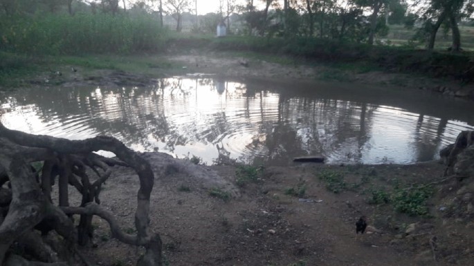
Hapa system at village Malthore of Belma GP in Purulia-2 block
-
(f)
Goira and Doba System: Goira and Doba are more or less similar in size, but in a few acute cases, Dobas have smaller areas than Goira. Both are small rainwater harvesting structures that are permanent or semi-permanent in nature. One dissimilar thing among these two water harvesting structures is that Goiras are adjacent to the human habitat (Fig. 16.11), with multiple uses ranging from fishing to cleaning. On the other hand, Doba is not uniform in structure; sometimes, they are too small that are only used for animal consumption (Fig. 16.12), and there are no such specific uses for Doba.
Fig. 16.11 
Goira structure in village Chakra of Lagda GP in Purulia-I block
Fig. 16.12 
Doba structure at Bela village of Bela GP in Balarampur block


On the other hand, as per the man-nature relation and changing pattern of climatic parameters, the necessity for the amalgamation of traditional knowledge and modern water harvesting methods can be a unique approach for a secure water future. Since not all areas are coping with traditional water harvesting techniques and not all require modern water harvesting techniques. Due to the manifestation of man-environment interrelation, the traditional WHTs also get shifted and assimilated with modern WHTs. Hence apart from considering nature-based traditional WHTs, we need to welcome modern techniques for water harvesting within a setup. In this circumstance, we have obtained the traditional WHTs (from the secondary data sources) and proposed modern WHTs for the Purulia district for dry land–water security (Table 16.3).
The overall water security and different water harvesting methods are well balanced through the amalgamation of the local community, government policy, and regulations, with the identification of problems and solutions by academic scholars. These three groups need to integrate and set out the methodology for attaining a secure water future in the dry land area like Purulia district. We must accept the fact that achieving absolute WS is next to impossible in some locations due to geophysical constraints and changing man-nature interaction. Table 16.2 represents the threefold class for managing water resources in the Purulia district, where each group has a distinct level of water harvesting strategies. The traditional society secures water in a natural and eco-friendly nature-based way, which is economically viable (Karim et al. 2021), sustainable (Li et al. 2021), and separated from any communal disputes (Mushavi et al. 2020). The second category is the proposed action plans given by different academic domains. The district is being recognized as an ultimate area for water security research, where disciplines like civil engineering detect the suitable site for the construction of water reservoirs and tanks (Bera and Das 2021; Agarwal et al. 2013); in the field of geology, detecting liniment density to construct artificial recharge got prioritized (Sur and Acharya 2020; Chowdhury et al. 2021); a few of literature on rural studies have shown perception studies on WS and climate change nexus (Basu 2021; Basu et al. 2021, 2017); agriculture scientists have shown crop suitability analysis with different small-scale irrigation method (Sarkar et al. 2014; Habibie et al. 2021); the multivariable issues have taken by geographers, where the significant number of pieces of literature have shown the site suitability analysis based on physical and social parameters to construct water reservoir (Kar et al. 2020) and drought assessment (Roy and Hazra 2020; Mishra and Desai 2005); in the field of zoology, different nature-based water harvesting methods are being prioritized (Bauri et al. 2020). Regional constraints and pre-existing provincial backwardness are major obstacles to applying the proposed water harvesting techniques given by scholars in different fields. Nevertheless, in the last decades, the region came into the light for the implementation of some state-level water-related policies like Jal Dharo Jal Bharo and Ushar Mukti that seek to endorse water harvesting strategies and ridge-to-valley development. The water governance in Purulia district has shown its reliability through the implementation of the West Bengal Inland Fisheries Act (WBIFA) successively in 1984 and 1997, which was mainly concerned with restoring tanks/ponds through the implementation of pisciculture where ownership can be transformed based on the norms and regulations (Chowdhury and Behera 2022). The main drawback of the above-mentioned schemes as they did not consider restoring ponds to secure water but rather launching pisciculture to strengthen the rural economy. As a result, the conservation of rural water bodies was not for water conservation but rather for securing the economy, which set out the dichotomy between economic enhancement and environmental consideration. Even per the act, local owners are bound to use their water bodies only for pisciculture, where they have no right to decide to utilize a pond system. During the eighth five-year plan (1992) state government launched Water User Association (WUA) which asserted that the local water users could make rules to restore and use water bodies effectively. During the second half of eight five-year plans, the Accelerated Irrigation Benefit Program (AIBP) was launched to promote micro-irrigation structures, including pond and canal water systems in rural areas. In 2005, the Mahatma Gandhi National Rural Employment Guarantee Act (MGNREGA) was launched to enhance employment in the rural sector, considered to provide irrigation water and enhance water infrastructure for agriculture production. However, MGNREGA has not meant to restore traditional water bodies in the rural sector, as it was not fully considered to restore water resources in the backward rural sector, rather paying attention to the specific water bodies which are efficient for irrigation purposes. Later on, in 2012, the National Wetlands Policy (NWP) was endorsed by West Bengal in different parts of the state, and it was the first time ponds and tanks were recognized as wetlands. The second half of NWP in 2018 was reversed from the first half, and it was not considered the pond and traditional water system as wetlands and practiced real estate development (Karthikeyan and Swathilekshmi 2017). Apart from the policies like WUA, AIBP, NWP, MGNREGA, and WBIFA, which are comprehensive and applied in every part of the state, programs like Ushar Mukti and Jal Dharo Jal Bharo are only meant to restore the dryland ecosystem and economy (GoI, 2014; 2018a; 2018b).
From the above discussion, it is clear that regions where water is inadequate need to have the amalgamation of local knowledge and modern water harvesting techniques for water sustainability. However, from the above discussion, some of the points that represent the gaps in water policy in the region that make it a prolonged water-insecure part of the state are as follows:
-
i.
Conventional water bodies have not been acclaimed as the base to secure water in the region; instead, they are categorized only as economic entities.
-
ii.
Excluding the programs like Jal Dharo Jal Bharo, most policies must be thoroughly water focused. For example, the Ushar Mukti program integrates land–water development through watershed improvement. However, it is the standard integration of all-natural resource development within a particular watershed instead of considering small water bodies and restoring the surrounding ecology.
-
iii.
Policy inconsistency is another gap that leads to water-stress conditions in the region. For example, the NWP in 2012 considered the pond water system a wetland. In contrast, NWP in 2018 tried to incorporate the traditional pond system for real estate development instead of considering them as a tool for the local economy and ecosystem enhancement.
-
iv.
In some instances, the spiritual beliefs on natural resources like water make aloofness from the regional policy where the occurrence of the struggle between indigenous values (religious or spiritual) and government policy regulation.
4 Limitation of the Study
The chapter undergoes with multi-level assessment of WHT in the light traditional knowledge for which it would be as essence to consider further observation on some of the extra water harvesting technologies by traditional society. In this regard, meticulous field examination is a way out to gather more information against the WHT by the traditional aboriginal society, but since many parts of the study area where the concentration of indigenous society is abundant are either inaccessible or unapproachable due to the geo-political constraints of the region. On the other hand, the current regional and global epidemic scenario there might be always a risk factor for overindulgence in some out-of-the-way parts of the study area.
5 Recommendations
The chapter primarily focuses on understanding aboriginal communities’ acceptability of traditional WHTs in dry lands. In some specific instances, there might be a symbiotic relationship between modern water collection and traditional methods. However, the traditional methods are superior in water-insecure regions. Here said, the traditional WHTs could parallel the dynamic changes of environmental entities. Regardless of the favorable implication of traditional WHTs, it is also established in some cases where traditional WHTs seem more viable on a small scale. Therefore, due to geophysical and economic constraints, only some parts of a region may be capable of environmentally responsive water harvesting methods. This becomes more prominent through the application of water restoration policies by the state government of West Bengal. However, from 2011 to 2017, three total master plans were applied in Purulia and adjoining other districts. However, the characteristics of the applied plans are more or less similar, which brings the critical question of satisfactorily identifying the problem. Therefore, to make a sustainable water-secure future for the district, we have highlighted some of the recommendations:
-
i.
First, the critical task is to identify the set of obstacles in different parts of the districts that creates water-stress condition.
-
ii.
Identification of different geophysical sites where water is highly scarce and their physical water availability
-
iii.
Make the traditional WHTs more appreciable through required assistance from local and state governments.
-
iv.
As water harvesting is not an essence but a practice, it must also be spared among the water-poor and water-rich communities.
-
v.
Creation of a hybrid water management system through the assimilation of planners and local community knowledge
-
vi.
Multilevel planning needs to be more effective where some of the planes are water-focused, and some plans need to be more all-inclusive.
-
vii.
Spreading out the concept to the community level that—water is a finite resource, it needs to treat as an economic good.
-
viii.
In some cases, spiritual beliefs become integral to restoring water. Therefore, government regulation and policies must be separated from indigenous norms and values.
-
ix.
Viable budget allocation and inclusive policy by state and central governments could bring more possibilities for sustainable changes for the district's water resources.
6 Conclusion
The present chapter seeks to endorse how traditional water harvesting methods could initiate and fill regional water demand and create a sustainable, secure future. Several works of literature have considered the positive aspects of TWH methods and water sustainability, particularly in a dry land where water is scarce. However, the research has not shown the long-term cost-benefit analysis of TWH methods in dry land. Is it possible that TWH methods would bring an optimum standard of living for the dry land communities? In this regard, it is obvious that the TWH methods are optimum for the water demand for small areal extensions.
On the other hand, it would be next to impossible to produce a bulk amount of productivity using TWH methods. Here, it is arguable whether economic efficiency and environmental conservation can parallel each other. It depends on a bunch of associated factors like policy, capital investment, and proper knowledge of resource utilization of local commons. The main problem in the global south, which brings non-parallel relation between environmental conservation and regional wealth generation, is regional biased development and negotiation of the marginal community by the name of adaptation. More simply, in the global south, capital investment is likely concentrated in some of the pre-developed parts of the country and areas where marginal communities are concentrated, and the planners impose nature-based resource utilization techniques. Even within the same region, the nature of water utilization could be seen in diverse ways. Where wealthy communities are likely utilizing water resources beyond their requirement, and aboriginal communities are under TWH methods. The traditional society adopts traditional resource management because they concentrate on fewer affluence parts within a region. Hence, adaptation of so-called eco-friendly resource management tools is only sometimes self-driven. Rather, they are associated with compromise and a lack of choices. In this scenario, adopting TWH methods or managing water resources is not only a choice but an essence, especially in the Indian scenario. Countries like India and other monsoon climatic regions must adopt water harvesting structures due to unpredictable climatic variables like rainfall and rising temperature. Hence, as we cannot control monsoons, we must make some positive behavioral changes, including recycling water, wastewater treatment, restriction in water consumption, and, most importantly, treating water resources as an economic good. Treating water resources as economic goodwill restricts the overconsumption of water, mostly among civil society. The managing system of water must have a network among the implementers, resource users, and moderators. Making a policy applicable in the long run requires the association of planners, policymakers, investors, and local commons. Moreover, for a more desirable eco-friendly water-secure future, the TWH methods need to be implemented to a larger extent with the association of traditional technology and modern water harvesting system. A sustainable water-secure future is not a sudden outcome; it is a daily practice for long-term solutions and a better water-secure future.
References
Abera TA, Heiskanen J, Pellikka P, Maeda EE (2018) Rainfall–vegetation interaction regulates temperature anomalies during extreme dry events in the Horn of Africa. Glob Planet Change 167:35–45
Abudu S, Sheng Z, Cui C, Guan D (2014) The karez system in China’s Xinjiang Region. Harvesting water and harnessing cooperation: Qanat systems in the Middle East and Asia, Middle East-Asia Project (MAP). http://www.mei.edu/content/harvesting-water-and-harnessing-cooperation-qanat-systems-middle-east-and-asia
Ackermann O, Zhevelev HM, Svoray T (2019) Agricultural systems and terrace pattern distribution and preservation along climatic gradient: from sub-humid mediterranean to arid conditions. Quatern Int 502:319–326
Adugna D, Jensen MB, Lemma B, Gebrie GS (2018) Assessing the potential for rooftop rainwater harvesting from large public institutions. Int J Environ Res Public Health 15(2):336
Agarwal R, Garg PK, Garg RD (2013) Remote sensing and GIS based approach for identification of artificial recharge sites. Water Resour Manage 27(7):2671–2689
Al-Ghafri A, Inoue T, Nagasawa T (2007) Irrigation scheduling of Aflaj of Oman. University of Hokkaido. www.inweh.unu.edu/inweh/drylands/Publications/AlGhafri
Ali A (2016) Water harvesting in dry environments. In: Innovations in dryland agriculture. Springer, Cham, pp 49–98
Alim MA, Rahman A, Tao Z, Samali B, Khan MM, Shirin S (2020) Suitability of roof harvested rainwater for potential potable water production: a scoping review. J Clean Prod 248:119226
Ammar A, Riksen M, Ouessar M, Ritsema C (2016) Identification of suitable sites for rainwater harvesting structures in arid and semi-arid regions: A review. Int Soil Water Conserv Res 4(2):108–120
Asase A, Nunoo FKE, Attipoe FYK (2016) Lake-based nursery rearing of Nile tilapia (Oreochromis niloticus) fingerlings in nylon hapas: Effects of stocking density on growth, survival and profitability. Agric Sci 7(10):660
Aziz F, El Achaby M, Ouazzani N, El-Kharraz J, Mandi L (2020) Rainwater harvesting: a challenging strategy to relieve water scarcity in rural areas. In: Smart village technology. Springer, Cham, pp 267–290
Bagli S, Tewari G (2019) Multidimensional poverty: an exploratory study in Purulia district West Bengal. Econ Aff 64(3):517–527
Basu JP (2021) Measurement of vulnerability of households and determinants of vulnerability. In: Climate change vulnerability and communities in agro-climatic regions of West Bengal, India. Springer, Cham, pp 81–99
Basu M, DasGupta R, Hashimoto S, Hoshino S (2021) A multi-actor and bottom-up perspective on attaining rural water security: qualitative evidence from India. Environ Dev Sustain 23(2):1461–1484
Basu M, Hoshino S, Hashimoto S, DasGupta R (2017) Determinants of water consumption: A cross-sectional household study in drought-prone rural India. Int J Disaster Risk Reduction 24:373–382
Bauri K, Gorai P, Modak BK (2020) Indigenous knowledge and practices on water conservation and management in purulia district, west bengal. J Environ Sociobiol 17(1):89–98
Beckers B, Berking J, Schütt B (2013) Ancient water harvesting methods in the drylands of the Mediterranean and Western Asia
Behailu BM, Pietilä PE, Katko TS (2016) Indigenous practices of water management for sustainable services: case of Borana and Konso Ethiopia. SAGE Open 6(4):2158244016682292
Bera A, Das S (2021) Water resource management in semi-arid Purulia district of West Bengal, in the context of sustainable development goals. In: Groundwater and society. Springer, Cham, pp 501–519
Berking J (2014) 2.4 Water harvesting around Petra, Jordan. Water Harvesting Drylands 55
Binyam AY, Desale KA (2015) Rainwater harvesting: An option for dry land agriculture in arid and semi-arid Ethiopia. Int J Water Resour Environ Eng 7(2):17–28
Bitterman P, Tate E, Van Meter KJ, Basu NB (2016) Water security and rainwater harvesting: a conceptual framework and candidate indicators. Appl Geogr 76:75–84
Borthakur S (2009) Traditional rain water harvesting techniques and its applicability
Bradford JB, Schlaepfer DR, Lauenroth WK, Palmquist KA (2020) Robust ecological drought projections for drylands in the 21st century. Glob Change Biol 26(7):3906–3919
Calianno M, Fallot JM, Ben Fraj T, Ben Ouezdou H, Reynard E, Milano M, ... Adatte T (2020) Benefits of water-harvesting systems (Jessour) on soil water retention in Southeast Tunisia. Water 12(1):295
Chambers DW, Gillespie R (2000) Locality in the history of science: Colonial science, technoscience, and indigenous knowledge. Osiris 15:221–240
Charles A, Berkes F (2021) Community-based approaches for linking conservation and livelihoods. Communities, conservation and livelihoods, p 4
Chowdhury K, Behera B (2022) Institutional dynamics and water resource management: the case of traditional water bodies in West Bengal, India. Int J Water Resour Dev 38(5):836–860
Chowdhury P, Mukhopadhyay BP, Nayak S, Bera A (2021) Hydro-chemical characterization of groundwater and evaluation of health risk assessment for fluoride contamination areas in the eastern blocks of Purulia district, India. Environ Dev Sustain, pp 1–28
Chowdhury P, Mukhopadhyay BP, Nayak S, Bera A (2022) Hydro-chemical characterization of groundwater and evaluation of health risk assessment for fluoride contamination areas in the eastern blocks of Purulia district, India. Environ Dev Sustain 24(9):11320–11347
Daripa SK (2019) Socio economic status of the tribals of Purulia district in the post colonial period. Int J Res Soc Sci 8(2):739–745
Das BR, Deka N, Bhagabati AK (2022) Reflection of nature in the material culture of the Karbi tribe: a case from Kamrup (M) district, Assam, India. Geogr J Nepal:63–82
Datta S, Das RC (2013) Fisheries legislation in India. Central Institute of Fisheries Education, Kolkata
De Pauw E (2008) Integrating expert knowledge in GIS to locate biophysical potential for water harvesting: methodology and a case study for Syria. Aleppo, Syria: Int Center Agric Res Dry Areas (ICARDA)
Deopura BL, Chahar BR (2011) Novel sheet material for water seepage control. Department of Textile Tecnology and Department of Civil Engineering, IIT Delhi
Dey S, Roy US, Chattopadhyay S (2015) Effect of heat wave on the Indian flying fox Pteropus giganteus (Mammalia: Chiroptera: Pteropodidae) population from Purulia district of West Bengal India. J Threatened Taxa 7(3):7029–7033
Dhehibi B, Haddad M, Strohmeier S, El-Hiary M (2020) Enhancing a traditional water harvesting technique in Jordan’s agro-pastoral farming system. Int Center Agric Res Dry Areas (ICARDA): Beirut, Lebanon
Dube T, Phiri K (2013) Rural livelihoods under stress: the impact of climate change on livelihoods in South Western Zimbabwe. Am Int J Contemp Res 3(5):11–25. https://ssrn.com/abstract=2347227. Accessed 28 Sept 2022
Dumont J (2002) Indigenous intelligence; have we lost our indigenous mind? Native Americas 19(3&4):15
Feng X, Stafford-Smith M, Zhang L, Lyu N, Lyu Y, Fu B, Xu Z (2020) Global dryland ecosystem programme (Global-DEP): Australasian consultation report. J Soils Sediments 20(4):1807–1810
Fessehaye M, Abdul-Wahab SA, Savage MJ, Kohler T, Gherezghiher T, Hurni H (2014) Fog-water collection for community use. Renew Sustain Energy Rev 29:52–62
File DJ, Derbile EK (2020) Sunshine, temperature and wind: community risk assessment of climate change, indigenous knowledge and climate change adaptation planning in Ghana. Int J Clim Change Strat Manage
Fitzwilliam-Hall S (2012) The Living Khettāras of Southern Morocco: a traditional water harvesting technology on the brink
Gadgil, M., Berkes, F., & Folke, C. (1993). Indigenous knowledge for biodiversity conservation. Ambio, 151–156
GoI (2014) National agroforestry policy 2014. The department of agriculture and co-operation. Ministry of Agriculture. http://agricoop.gov.in/sites/default/files/National_agroforestry_policy_2014.pdf
GoI (2018a) National forest policy, 2018a. The ministry of environment, forest and climate change. https://tribal.nic.in/FRA.aspx. Accessed 26 Sept 2022
GoI (2018b) National wetland policy, 2018b. The ministry of environment, forest and climate change. http://www.indiaenvironmentportal.org.in/content/447822/wetlands-conservationand-management-rules-2017/
GoWB (2011) JalDharo-JalBharo programme. Panchayat and rural development department, government of West Bengal. http://wbwridd.gov.in/wrdd/jal_dharo_jal_bharo.html. Accessed 26 Sept 2022
Gunara S, Sutanto TS, Cipta F (2019) Local knowledge system of Kampung Naga: a study to investigate the educational values of indigenous people in transmitting religious and cultural values. Int J Instr 12(3):219–236
Gyampoh BA, Amisah S, Idinoba M, Nkem J (2009) Using traditional knowledge to cope with climate change in rural Ghana. Unasylva 60(281/232):70–74
Habibie MI, Noguchi R, Shusuke M, Ahamed T (2021) Land suitability analysis for maize production in Indonesia using satellite remote sensing and GIS-based multicriteria decision support system. GeoJournal 86(2):777–807
Halder S, Sadhukhan D (2012) Adaptability of water management strategies in the context of Climate change for drought prone areas of West Bengal. In: International conference on impact of climate change on water resources, At: Karunya University, Coimbatore, India
Hardiman D (1998) Well irrigation in Gujarat: systems of use, hierarchies of control. Econ Polit Wkly:1533–1544
Holmatov B, Lautze J, Manthrithilake H, Makin I (2017) Water security for productive economies: applying an assessment framework in southern Africa. Phys Chem Earth, Parts a/b/c 100:258–269
Hoque S, Alam MB (2012) The Laleng indigenous community of Sylhet: changing pattern in political organization. Asian Profile 40(2):97–105
Islam MR (2013) Indigenous knowledge as social capital. Int J Soc Sci 1:68–79
Jacoby T (2003) For the people, of the people and by the military: the regime structure of modern Turkey. Polit Stud 51(4):669–685
Jana SK (2011) Sustainable ssmall scale irrigation experiment in the dry zones: a case study on Happa (small tank) model in the state of West Bengal, India
Jobbins G, Ludi E, Calderone M, Sisodia R, Sarwar MB (2018) ‘Leaving no one behind’ through enabling climate-resilient economic development in dryland regions
Joks S, Østmo L, Law J (2020) Verbing meahcci: Living Sámi lands. Sociol Rev 68(2):305–321
Jones ER, Van Vliet MT, Qadir M, Bierkens MF (2021) Country-level and gridded estimates of wastewater production, collection, treatment and reuse. Earth Syst Sci Data 13(2):237–254
Kar S, Sen E, Mukherjee S (2020) A geospatial technique‐based site suitability analysis for construction of water reservoirs in Arsha and Balarampur Blocks, Purulia. World Water Policy 6(1):52–88
Karim MR, Sakib BS, Sakib SS, Imteaz MA (2021) Rainwater harvesting potentials in commercial buildings in Dhaka: reliability and economic analysis. Hydrology 8(1):9
Karthikeyan C, Swathilekshmi PS (2017) An analysis of the types and pattern of uses and control rights over multiple uses of tank irrigation system in South India. Indian J Dryland Agric Res Dev 32(2):34–44. https://doi.org/10.5958/2231-6701.2017.00021.5.Accessedon26.09.2022
Khan ML, Khumbongmayum AD, Tripathi RS (2008) The sacred groves and their significance in conserving biodiversity: an overview. Int J Ecol Environ Sci 34(3):277–291
Khoobfekrbarabadi H, Hosainimarandi H, Arabkhedri M (2020) Native and traditional rainwater harvesting systems in Balochistan of Iran. Indigenous Knowl 6(12):279–306
Kibassa D (2013) Indigenous rain water harvesting practices for climate adaptation in food security in dry areas: the case of Bahi district
Kolekar SS, Mishra A, Choudhari P, Choudhari NR (2021) Identification of specific areas for water conservation measures using Geoinformatics approach. Arab J Geosci 14:1–13
Kumar S, Ramilan T, Ramarao CA, Rao CS, Whitbread A (2016) Farm level rainwater harvesting across different agro climatic regions of India: assessing performance and its determinants. Agric Water Manage 176:55–66
Kuokkanen R (2018) Gendered environmental assessments in the Canadian north: marginalization of indigenous women and traditional economies. Gendered Environmental Assessments in the Canadian North.” Co-authored with Sheena Kennedy Dalseg, Suzanne Mills and Deborah Simmons. Northern Rev 47:135–166
Kurothe RS, Kumar G, Singh R, Singh HB, Tiwari SP, Vishwakarma AK, ... Pande VC (2014) Effect of tillage and cropping systems on runoff, soil loss and crop yields under semiarid rainfed agriculture in India. Soil Tillage Res 140:126–134
Lakel WA III, Aust WM, Bolding MC, Dolloff CA, Keyser P, Feldt R (2010) Sediment trapping by streamside management zones of various widths after forest harvest and site preparation. Forest Sci 56(6):541–551
Lebel T, Cappelaere B, Galle S, Hanan N, Kergoat L, Levis S, ... Seguis L (2009) AMMA-CATCH studies in the Sahelian region of West-Africa: an overview. J Hydrol 375(1–2):3–13
Leite-Filho AT, Soares-Filho BS, Davis JL, Abrahão GM, Börner J (2021) Deforestation reduces rainfall and agricultural revenues in the Brazilian Amazon. Nat Commun 12(1):1–7
Li Z, Xu X, Sheng X, Lin P, Tang J, Pan L, ... Yamauchi Y (2021) Solar-powered sustainable water production: state-of-the-art technologies for sunlight–energy–water nexus. ACS Nano 15(8):12535–12566
Lian X, Piao S, Chen A, Huntingford C, Fu B, Li LZ, ... Roderick ML (2021) Multifaceted characteristics of dryland aridity changes in a warming world. Nat Rev Earth Environ 2(4):232–250
Lyons I, Hill R, Deshong S, Mooney G, Turpin G (2020) Protecting what is left after colonisation: embedding climate adaptation planning in traditional owner narratives. Geogr Res 58(1):34–48
Machiwal D, Jha MK, Singh PK, Mahnot SC, Gupta A (2004) Planning and design of cost-effective water harvesting structures for efficient utilization of scarce water resources in semi-arid regions of Rajasthan India. Water Resour Manage 18(3):219–235
Maes J, Jacobs S (2017) Nature-based solutions for Europe’s sustainable development. Conserv Lett 10(1):121–124
Maldonado JK, Colombi B, Pandya R (2016) Climate change and indigenous peoples in the United States. Springer, p 93
Malik RPS, Giordano M, Sharma V (2014) Examining farm-level perceptions, costs, and benefits of small water harvesting structures in Dewas, Madhya Pradesh. Agric Water Manage 131:204–211
Marzol, M. V., & Sánchez, J. (2008). Fog water harvesting in Ifni, Morocco. An assessment of potential and demand. Die Erde 139(1–2), 97–119
McGregor D (2009) Linking traditional knowledge and environmental practice in Ontario. J Can Stud 43(3):69–100
Melkania NP (2008) Indigenous Knowledge of Apatani Tribe of Cultivation and Utilization of Runner Bamboo (Phyllostachys bambusoides Gamble) in Arunachal Pradesh. Indian Forester 134(3):344
Meter KJV, Basu NB, Tate E, Wyckoff J (2014) Monsoon harvests: the living legacies of rainwater harvesting systems in South India
Mishra AK, Desai VR (2005) Drought forecasting using stochastic models. Stoch Env Res Risk Assess 19(5):326–339
Mishra PK, Rai SC (2013) Use of indigenous soil and water conservation practices among farmers in Sikkim Himalaya
Mishra PK, Parey A, Saha B, Samaddar A, Chakraborty S, Kaviraj A, ... Saha S (2022) Production analysis of composite fish culture in drought prone areas of Purulia: the implication of financial constraint. Aquaculture 548:737629
Morris B (2010) Indigenous knowledge. Soc Malawi J 63(1):1–9
More HB (2020) A review of Indian traditional method of rain water harvesting. Int J Innov Res Sci Eng Technol 9(4):2080–2086
Moura LC, Scariot AO, Schmidt IB, Beatty R, Russell-Smith J (2019) The legacy of colonial fire management policies on traditional livelihoods and ecological sustainability in savannas: Impacts, consequences, new directions. J Environ Manage 232:600–606
Mushavi RC, Burns BF, Kakuhikire B, Owembabazi M, Vořechovská D, McDonough AQ, ... Tsai AC (2020) When you have no water, it means you have no peace: a mixed-methods, whole-population study of water insecurity and depression in rural Uganda. Soc Sci Med 245:112561
Naik SK, Mali SS, Das B, Bhatnagar PR, Kumar S, Sikka AK (2016) Rainwater harvesting using plastic-lined doba technology for orchard establishment in the eastern plateau and hill region of India. Curr Sci 111(11):1751–1753
Omrani N, Ouessar M (2008) Historical and contemporary perspectives of water culture in Tunisia. Water culture and water conflict in the Mediterranean area. Series: Options Méditerranéennes. Série a: Séminaires Méditerranéens 83:75–84
Oweis TY, Prinz D, Hachum AY (2012) Rainwater harvesting for agriculture in the dry areas. CRC Press
Oweis T, Hachum A (2006) Water harvesting and supplemental irrigation for improved water productivity of dry farming systems in West Asia and North Africa. Agric Water Manage 80(1–3):57–73
Oweis T, Hachum A (2009) Water harvesting for improved rainfed agriculture in the dry environments. Rainfed agriculture: unlocking the potential, pp 164–182
Oweis T, Prinz D, Hachum A (2001) Water harvesting. Indigenous knowledge for the future of the drier environments. Int Centre Agric Res Dry Areas (ICARDA), Aleppo, Syria:40
Parwada C, Chipomho J, Mandumbu R (2022) In-field soil conservation practices and crop productivity in marginalized farming areas of Zimbabwe. In: Food security for African smallholder farmers. Springer, Singapore, pp 75–87
Patel B, Patel A, Syed BA, Gami B, Patel P (2021) Assessing economic feasibility of bio-energy feedstock cultivation on marginal lands. Biomass Bioenerg 154:106273
Petersen M, Bergmann C, Roden P, Nüsser M (2021) Contextualizing land-use and land-cover change with local knowledge: a case study from Pokot Central Kenya. Land Degrad Dev 32(10):2992–3007
Prinz D (1996) Water harvesting—past and future. In: Sustainability of irrigated agriculture. Springer, Dordrecht, pp 137–168
Prinz D (2002) The role of water harvesting in alleviating water scarcity in arid areas. In: Keynote lecture, proceedings, international conference on water resources management in arid regions, pp 23–27
Prinz D, Singh A (2000) Technological potential for improvements of water harvesting. Gutachten für die World Commission on Dams, technical papers, 126
Rajendran CP, Rajendran K, Andrade V, Srinivasalu S (2013) Ages and relative sizes of pre-2004 tsunamis in the Bay of Bengal inferred from geologic evidence in the Andaman and Nicobar Islands. J Geophys Res Solid Earth 118(4):1345–1362
Reddy DN (2012) MGNREGS and Indian agriculture: opportunities and challenges. Right to Work and Rural India: Working of the Mahatma Gandhi National Rural Employment Guarantee Scheme (MGNREGS), p 246
Robertson JA, Conigrave KM, Ivers R, Usher K, Clough AR (2012) Translation of tobacco policy into practice in disadvantaged and marginalized subpopulations: a study of challenges and opportunities in remote Australian Indigenous communities. Health Res Policy Syst 10(1):1–12
Rockström J, Karlberg L, Wani SP, Barron J, Hatibu N, Oweis T, ... Qiang Z (2010) Managing water in rainfed agriculture—the need for a paradigm shift. Agric Water Manage 97(4):543–550
Roy S, Hazra S (2020) Monthly drought assessment and early warning for Droughts in Purulia District of West Bengal. Indian Ground Water, XV
Salick J, Staver B, Hart R (2020) Indigenous knowledge and dynamics among Himalayan peoples, vegetation, and climate change. In: Changing climate, changing worlds. Springer, Cham, pp 55–69
Samani AAN, Khalighi S, Arabkhedri M, Farzadmehr J (2014) Indigenous knowledge and techniques of runoff harvesting (Bandsar and Khooshab) in arid and semi arid regions of Iran. J Water Resour Prot
Samuel MP, Mathew AC (2008) Rejuvenation of water bodies by adopting rainwater harvesting and groundwater recharging practices in catchment area-a case study. In: Proceedings of Taal2007: the 12th world lake conference, vol 766. Ministry of Environment and Forests, Government of India Jaipur, India, p 776
Sandlos J, Keeling A (2016) Aboriginal communities, traditional knowledge, and the environmental legacies of extractive development in Canada. Extr Ind Soc 3(2):278–287
Sarkar A, Ghosh A, Banik P (2014) Multi-criteria land evaluation for suitability analysis of wheat: a case study of a watershed in eastern plateau region India. Geo-Spatial Inf Sci 17(2):119–128
Sarkar SM (2018) Rainwater harvesting technology and water use practices: a study from Purulia District of West Bengal, India. IMPACT: Int J Res Humanit Arts Lit (IMPACT: IJRHAL) 6(8):583–596
Sharma SB (2017) Traditional ecological knowledge-based practices and bio-formulations: key to agricultural sustainability. In: Probiotics in agro ecosystem. Springer, Singapore, pp 407–415
Sintayehu DW (2018) Impact of climate change on biodiversity and associated key ecosystem services in Africa: a systematic review. Ecosyst Health Sustain 4(9):225–239
Sinthumule NI, Mashau ML (2020) Traditional ecological knowledge and practices for forest conservation in Thathe Vondo in Limpopo Province South Africa. Glob Ecol Conserv 22:e00910
Sivakumar MVK, Vittal KPR, Eslamian S (2021) Indian experiences in water harvesting systems. Handbook of water harvesting and conservation: case studies and application examples, pp 325–339
Sixt GN, Klerkx L, Griffin TS (2018) Transitions in water harvesting practices in Jordan’s rainfed agricultural systems: Systemic problems and blocking mechanisms in an emerging technological innovation system. Environ Sci Policy 84:235–249
Soni J (2006) Water accessibility and marginalisation of dalits some observation of rural Gujarat. In: Prepared for the workshop titled water, law and the commons organised by the international environmental law research centre
Srinivasan V, Konar M, Sivapalan M (2017) A dynamic framework for water security. Water Secur 1:12–20
Stojanović V, Demonja D, Mijatov M, Dunjić J, Tišma S (2022) Concept of ecotourism development in UNESCO biosphere reserves: Case studies from Croatia and Serbia. Šumarski List 146(5–6):243–253
Strohmeier S, Fukai S, Haddad M, AlNsour M, Mudabber M, Akimoto K, ... Oweis T (2021) Rehabilitation of degraded rangelands in Jordan: the effects of mechanized micro water harvesting on hill-slope scale soil water and vegetation dynamics. J Arid Environ 185:104338
Sur T, Acharya T (2020) Filtering of hydraulically significant lineaments from lineament map of precambrian metamorphic terrain in NE India using set theory. Groundw Sustain Dev 11:100469
Tamaddun K, Kalra A, Ahmad S (2018) Potential of rooftop rainwater harvesting to meet outdoor water demand in arid regions. J Arid Land 10(1):68–83
Tepper Y, Porat N, Bar-Oz G (2020) Sustainable farming in the Roman-Byzantine period: Dating an advanced agriculture system near the site of Shivta, Negev Desert Israel. J Arid Environ 177:104134
Tonts M, Martinus K, Plummer P (2013) Regional development, redistribution and the extraction of mineral resources: the Western Australian Goldfields as a resource bank. Appl Geogr 45:365–374
Tumbo SD, Mbilinyi BP, Mahoo HF, Mkilamwinyi FO (2013) Identification of suitable indices for identification of potential sites for rainwater harvesting. Tanzania J Agricult Sci 12(2)
Vohland K, Barry B (2009) A review of in situ rainwater harvesting (RWH) practices modifying landscape functions in African drylands. Agr Ecosyst Environ 131(3–4):119–127
Wessels J (2003) Qanats in Syria ease the water shortage. WATERLINES-LONDON- 22(2):8–10
Willemen L, Crossman ND, Quatrini S, Egoh B, Kalaba FK, Mbilinyi B, de Groot R (2018) Identifying ecosystem service hotspots for targeting land degradation neutrality investments in south-eastern Africa. J Arid Environ 159:75–86
Wilson WA (2004) Introduction: indigenous knowledge recovery is indigenous empowerment. Am Indian Q:359–372
Zakaria S, Al-Ansari N, Knutsson S, Ezz-Aldeen M (2012) Rain water harvesting and supplemental irrigation at Northern Sinjar Mountain, Iraq. J Purity, Utility React Environ 1(3):121–141
Zhang C, Dong Z, Guo Q, Hu Z, Li J, Wei T, ... Jia Z (2022) Ridge–furrow rainwater harvesting combined with supplementary irrigation: water-saving and yield-maintaining mode for winter wheat in a semiarid region based on 8-year in-situ experiment. Agric Water Manage 259:107239
Author information
Authors and Affiliations
Corresponding author
Editor information
Editors and Affiliations
Rights and permissions
Copyright information
© 2023 The Author(s), under exclusive license to Springer Nature Switzerland AG
About this chapter

Cite this chapter
Kar, S., JibanbandhuGayak, Khan, K.R., Satpati, L., Mukherjee, S. (2023). Achieving Rural Water Security Through Traditional Knowledge: A Comprehensive Appraisal of Traditional Water Harvesting Techniques Used in Dry Lands of Purulia District, West Bengal, India. In: Panda, G.K., Chatterjee, U., Bandyopadhyay, N., Setiawati, M.D., Banerjee, D. (eds) Indigenous Knowledge and Disaster Risk Reduction. Disaster Risk Reduction. Springer, Cham. https://doi.org/10.1007/978-3-031-26143-5_16
Download citation
DOI: https://doi.org/10.1007/978-3-031-26143-5_16
Published:
Publisher Name: Springer, Cham
Print ISBN: 978-3-031-26142-8
Online ISBN: 978-3-031-26143-5
eBook Packages: Earth and Environmental ScienceEarth and Environmental Science (R0)