
Abstract
Drone technology, also known as Unmanned Aerial Vehicles (UAVs), has digitally transformed the construction industry and gained much application in architecture, engineering, and construction operations. The digitalization of the construction industry, recently known as construction 4.0, has made drone technologies a piece of essential equipment for proper monitoring of construction activities from commencement to completion of the project.
Access provided by Autonomous University of Puebla. Download chapter PDF
1 Introduction
Drone technology, also known as Unmanned Aerial Vehicles (UAVs), has digitally transformed the construction industry and gained much application in architecture, engineering, and construction operations. The digitalization of the construction industry, recently known as construction 4.0, has made drone technologies a piece of essential equipment for proper monitoring of construction activities from commencement to completion of the project.
Historically, drones have been around for some while now. However, before now, drones were mainly built and researched for military purposes. Over the years, and with tremendous improvements in drone technology, civilian applications of UAVs have gained wide popularity (Albeaino et al., 2019; Tatum & Liu, 2017; Zhou & Gheisari, 2018). It was noted by Sanson (2019) that in 1849, the Austrian empire utilized hot air balloons to drop bombs on Venice in the first Italian War of Independence. The first exemplar of modern UAV with the capability of an autonomous flight coupled with -range and wireless links to the ground station was developed in 1944 during the Second World War (Giordan et al., 2020). About the year 2000, the recreational and commercial drones began to show up and by 2006 issuing commercial drone permits in the United States started, with about two permits issued per year (Devers, 2019; Ford, 2018). Thereafter, drones such as Parrot AR Drone and DJI Platinum were available for civil and commercial purposes (Devers, 2019; Lin, 2018). In 2014, the development of drone technology for commercial use caught the construction industry's attention (Lin, 2018). Since 2014, the construction industry has experienced several applications of drone technologies in areas such as: site security, safety inspection, construction monitoring, etc.
Drones technology can be described as a flying robot that can be remotely regulated by flight software and Global Positioning systems. A drone is a recognizable airplane remotely controlled for data collection. Drones vary in size, and it contains topographic measurement used to survey buildings, roads, highways, bridges and any surface region. These technologies are built with intelligent stabilization systems, sensors, and cameras that can fly, perform dedicated functions, and obtain high-quality video photography (Accenture, 2016). They are structured to provide information regarding work progress, locations of certain objects on larger sites, and even survey elevations and topography of the prebuilt land (Higgins, 2017). Generally, the term drone refers to autonomously guided aircraft, including submarines or land-based autonomous vehicles (Yaacoub et al., 2020).
Drones are likened to an automated plane and are often called Unmanned Aerial Vehicles (UAVs); Unpiloted Aircraft System (UAS); Remote Piloted Aircraft System (RPAS); Quadcopter etc. (Albeaino et al., 2019; Fox, 2017; Giordan et al., 2020; Tatum & Liu, 2017). Generally, drones can be described as a device capable of flying and can either be controlled remotely or controlled autonomously by software. Drones mainly focuse on “flying” and are controlled remotely or autonomously. Unmanned Aerial Vehicles (UAVs) do not require a pilot, but are airborne systems controlled through ground control stations. Tatum and Liu (2017) defined an Unmanned Aircraft System (UAS) as an aircraft system that a pilot on ground flies. Grayson (2016), as cited in Tatum and Liu (2017), noted that the term drone might also broadly refer to any equipment operated independently of human control. Giordan et al, (2020) also stated in their study that a UAV is referred to as an unmanned aerial system, which can have an autonomous flight with or without an engine, can be remotely controlled, and collect data. Defining a construction drone would be tasking, but it can be defined as a device that is airborne, controlled remotely, or through software deployed for construction activities: such as traffic monitoring, surveillance or survey mapping, site navigations, material tracking, and inspection, etc.
In recent times, the use of drones in the engineering and construction industry is increasing. It has enhanced the key stages of delivering a quality project, including pre-planning, planning, inspection, construction and post-construction, and monitoring. Drones have brought about developments in the construction industry by improving safety, reducing cost, reporting precision, and increasing efficiency. Construction projects are rapidly evolving beyond past standards, and commercial drones are driving technical evolution, thereby spurring industrial change across construction sites (DeYoung, 2018). In the construction industry, drones have proven to be a valuable technological development due to their success in data sharing for project execution. Also, drones present aviation opportunities and abilities that have helped resolve many challenges faced on the construction site. In the construction industry, drones are used explicitly on construction sites for several purposes. These include project design pre-construction site assessment, mapping, aerial surveying, material stockpiles, locating utilities, workers and equipment measurement of excavation pits, monitoring site progress, inspection, security, and safety. Drones are equipped with high-resolution cameras, Global Positioning System (GPS), ultrasound devices, radio-frequency identification readers, laser scanners, and remote sensors for: imagery, data collection to detect objects, surveying, measure distance, inventory, and equipment tracking. Today, the industry has experienced tremendous improvement due to drones and UAVs used for several stages of the construction projects. In light of the growing advancement in drones, drones are expected to create more jobs, thereby increasing drone application usage in the construction industry. Drones are manufactured for commercial and combat purposes. Military drones are the first innovation of drones specifically manufactured for defense and used by military force for intelligence surveillance and weapon of delivery during combat.
On the other hand, commercial drones are drones manufactured for the use and control of civilians. For many years now, commercial drones are primarily used in the construction industry (Zitzman, 2018). According to the Federal Aviation Administration (2018), approximately 79% of commercial drone usage is used for public and private construction projects, aiding project site inspections and civil engineering endeavors.
1.1 Components of a Drone
A drone can be sophisticated based on components, uses, and area of application. In its simplest form, the main elements of a drone are classified into three which are;
-
i.
the aerial platform (for flying);
-
iii.
the ground control station (for remote or autonomous control); and
-
iii.
the communication system (for synergy between components) (Giordan, 2020).
Components of a drone are based on authors and expert lexical register; There are several classifications of the elements of drones provided by various authors. Tatum and Liu (2017) stated that the elements of drones include the drone itself and the control system, ground and satellite-based equipment, communication links, and operators which are required to operate the aircraft effectively and safely. Sanson (2019) itemized components of a typical drone as consisting of a: quadcopter, four propellers, motor, landing gear, battery, camera, and remote control.
Tatale, Anekar, Phatak, and Sarkale, (2018) also stated that the main part of the quadcopter is a frame that has four arms and should be light and rigid to host: a LIPO battery, four brushless DC motors (BLDC), controller board, four propellers, a video camera and different types of sensors along with a light frame as shown in Fig. 4.1.

Drone/quadcopter structure (Tatale et al., 2018)
According to Ostojić, Stankovski, Tejić, Đukić, and Tegeltija, (2015), quadcopters can have a very different hardware component which is dependent on the application in which they will be employed. They furthered that the standard features of a quadcopter are microcontroller, sensors, motors, Global Positioning System (GPS) power supply, and telemetry devices.
In summary, the component of a drone may vary based on the control system, either autonomous using programmed navigation software or remotely controlled by a person). Regardless of the variations, components that can make a drone fly, communicate with the base station (that is, operate autonomously or gather data into a storage device), and onboard communication between two or more components must be available. Considering the various components enumerated by multiple authors, a summary of the various components of a drone and their functions is detailed below.
Components that enable a drone to fly include the following:
-
a.
Battery: all electronics need electricity to function. Therefore, the battery supplies the necessary electricity required for the drone and its components to work. In light of the preceding, the battery can be referred to as the life of the drone—once it goes off, the drone comes down. The higher the battery capacity, the more time a drone can stay fully functional in the air.
-
b.
Propeller and Motor: These are used for navigation and take-offs. The propeller and motor provide thrust, which are responsible for the drone's movement from the ground up and back on the ground. They are the wheels of the drone.
-
c.
Frame: This allows for the attachment of other devices. The frame is the body of the drone and also houses the weight of the drone.
-
d.
Landing Gear: This is the stand or leg of the drone, and it is important for balance while on the ground or in the air. The landing gear bears the weight of the frame and other components attached to the frame.
Components that establish communication with a base station and visuals include the following:
-
a.
GPS Antenna: This component is used to establish a proper connection between the drone, location, and base station for adequate interaction. The GPS is responsible for sending and receiving tracking, location, mapping, location signals, etc. The GPS and other sensors like infra-red and ultrasonic sensors are used for navigation purposes, to avoid collision, and altitude control.
-
b.
Camera: This is used for visuals when flying. The camera is the essence of the drone because the work of a drone is to get you where you cannot access. The camera helps in gathering programmed data by taking aerial snapshots, providing imagery and video recording to the mapped area.
Components that establish communication between two or more components include the following:
-
a.
Control Board: This is the drone's brain, and it helps coordinate, give and interpret instructions and commands given to a drone. The control board is responsible for telling other components what to do, when to do it and how to do it when a remote user or programmed software initiates a command.
-
b.
Microcontrollers: these provide a set of digital and analog I/O pins that can be interfaced to various expansion boards (shields) and other circuits. The microcontrollers control the overall performance of a quadcopter, such as flying mechanisms and live streaming of videos. The boards feature serial communications interfaces, including USB on some models for loading programs from personal computers (Tatale et al., 2018).
1.2 Classification of Drones
Classification of drones varies, but basically, drones are classified as autonomous and non-autonomous depending on the control system (Kazi et al., 2018). Autonomous drones are controlled from remotely spaced programmable computers using an onboard autopilot and global positioning system (GPS); in other words, an autonomous drone flies and carry out programmed functions without human interference. Non- Autonomous drones are controlled or piloted manually using a remote controller requiring a skilled operator. Structurally, a drone can also be classified as an Aircraft drone or a Copter drone (Kazi etal., 2018). Aircraft drones are fashioned to look like planes with wings attached to it for flight; these types of aircraft are popularly used by military and security operatives and are famous for their high-speed flying ability. An aircraft drone needs a runway to take off and land. Copter drones are fashioned after a rotorcraft, or like a helicopter whose flight and thrust are supplied by spinning rotors. Drones within this classification are often referred to as quadcopters and are suitable for recreational and commercial purposes within a highly dense urban area (Kazi et al., 2018).
Unmanned Aerial Vehicles are multifaceted, with over 28 variations based on the single qualifier of flying principles alone. The most inclusive classification of Drones is based on operating mass/weight and UAV’s purpose of flight/usage. Classification based on operating mass can either be heavier-than-air or lighter-than-air. On the other hand, the classification of UAV based on flight usage is categorized as flight time versus UAV mass and degree of autonomy versus degree of sociability. Figure 4.2 illustrates common UAV types given a respective vehicular mass differentiation between heavier-than-air and lighter-than-air.
1.2.1 Classification of Drones/Unmanned Aerial Vehicles Based on Operating Mass/Weight
-
(i)
Heavier-than-air: The heavier-than-air UAVs have substantial vehicle mass relying on aerodynamics and propulsive thrust to fly. This classification of drones is sub-classified into wing or rotor types for drone type determination. Wing-type UAVs comprise fixed-wing, flying-wing, and flapping-wing methodologies to generate aerodynamic lift. On the other hand, Rotor-type UAVs include a plethora of multi-rotors by combining multiple rotors and propellers, which point upwards to create propulsive thrust for its lift (Fig. 4.2).
Fig. 4.2 
Common unmanned aerial vehicles classification (Liew et al., 2017)
-
(ii)
Lighter-than-air: The lighter-than-air UAVs rely on buoyancy forces such as helium gas or heated air to fly. They have an extended stamina flight capacity which can be used for photography and surveillance. One major setback/constraint of the lighter-than-air UAVs is its inability to maneuver, requiring tethered/rope to keep it from drifting due to the wind. Examples include blimps and balloons (Fig. 4.3).
Fig. 4.3 
Categories of Heavier-than-air drones (Hassanalian & Abdelkefi, 2017)


1.2.2 Classification of Drones/Unmanned Aerial Vehicles Based on Purpose of Flight/Usage.
-
(i)
Flight time versus UAV Mass: One factor to consider when purchasing a drone is flight time. On average, the flight time of drones ranges from 15 to 30 min, dependent on the battery energy, design range of flight, and weather condition. However, a non-racing drone can fly between 30 to 60 min, while a racing drone can fly for 125 min per hour. More often, the battery capacity determines the flight time of a drone. Also, UAV mass implies the weight of drones which also varies. It can be bigger/heavier or lighter and smaller.
-
(ii)
Degree of Autonomy Versus Degree of Sociability: The degree of autonomy is the capability of drones or UAVs to take off, carry out the specific task and return to their base without significant human involvement. In essence, the technology is programmed with the tasks required to be executed without the need of an operator. The attainment of UAV autonomy shows a significant level of achievement of any technology inventor. The degree of sociability describes the extent to which a drone can interact or collaborate with humans. Such categories of drones are developed with software that enables them to communicate with a human. As a result, these drones have a lower degree of autonomy due to manual control. (Liew et al., 2017).
1.3 Types of Drones Used in the Construction Industry
In recent years, drones in the construction industry are one of the most striking trends. This accounts for almost a 240% increase in drone use compared to other sectors of the economy. Even though there are various types of drones, the construction industry mainly uses commercial drones. Examples of these drones are listed below (Tkac and Mesaros (2019)
-
(i)
Single Rotor: A single rotor is a type of drone one rotor with a propeller to control it. The single rotor drone comes with a simple design, is low cost, is easy to start and move, and has shown greater efficiency than the drones with multiple rotors (multi-rotor). However, they are nor no strong, which requires caution when landing and a lot of maintenance
-
(ii)
Multi-Rotor: Multi-rotor is a common type of UAV that makes use of more than two rotors. They are categorized based on the number of rotors. For example, the UAV’s that make use of three rotors are called the tricopters, while four rotors are called quadcopters, six rotors hexacopters, and eight rotors UAV’s are called (octocopters). Multi-rotors comprise fixed-pinch spinning blades that produce lift. Multi-rotor drones are used for professional aerial mapping and pleasure. These types of drones are primarily used for video recording, photography, and aerial surveying. Two significant advantages of motor rotors are the drone's ease of operation and affordability option in getting “an eye in the sky.” However, multi-rotor drones are limited in speed and endurance. As a result, it cannot be used for long-distance inspection, large scale aerial mapping, and long endurance monitoring. An example of a multi rotor drones is the DJI Matrice 210 used at the Allianz Fieldin Minnesota (Fig. 4.4).
Fig. 4.4 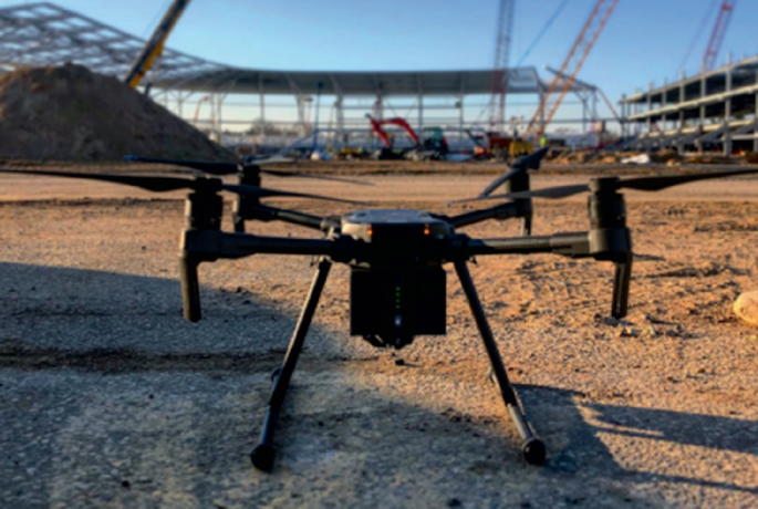
An example of a multi rotor drone (Gibson & McManmon, 2018)
-
(iii)
Fixed Wing Drones: A fixed-wing drone which can also be referred to as an-unmanned aerial vehicle or system, is a firm structure of aircraft that used a fixed or static wing to generate lift. It is custom-built with an internal engine to ensure proper functioning. This Fixed-wing drones can fly longer distances within a short time. As a result, it is considered more efficient than other types of drones regarding topographic mapping, energy efficiency, and its ability to reach a high altitude during flight. Also, this type of drone has a higher carriage capacity (payloads) and survives in harsh weather conditions. The fixed-wing drones also present some shortcomings regarding landing as it is restricted to moving forward only. In time past, this type of drone was used by the military for surveillance during the war. Nevertheless, in recent times it has become a standard tool used by several industries, including construction. Common fixed-wing drones include straight wing, delta wing, and a swept wing.
-
(iv)
Hybrid Systems: Hybrid systems of drones are drones developed to solve some of the constraints of the single, multi-rotor, and fixed wings drones. This system of drones possesses the features of multi-rotors and fixed wings. This type of drone has wings and multiple rotors. These features enable it to take off quickly, climb, hover, fly a longer distance, and land with little energy consumption. It can hover like a helicopter and fly like a plane. It has the advantages of stability, flexibility, and fuel efficiency. Hybrid drones operate by flying a pre-schedule flight route at a specified height of a user, gather data through its color and multi-specified sensors, and land vertically to the starting point (Tkac & Mesaros, 2019). An example of a hybrid system of drones is the quadrotor (Fig. 4.5).
Fig. 4.5 
A mini Quadrotor (Papa et al., 2017)


2 Application Drone Technology in the Construction Industry
Implementing drones’ technology in the construction industry has made the construction work more efficient and sustainable. The use of drones has gained more attention in the construction and engineering field due to the swift, safe, and low-cost access to visual data, thereby providing spatial information about hazardous geographical locations. These technologies permit construction companies to utilize the data collected from drones to perform processes and improve almost all aspects of construction management. Consequently, drones/aerial vehicles are adopted in the construction industry for several purposes, which include the following:
I. Construction Site Inspections.
Inspection is a key activity in the construction process, and drone technology has enhanced this procedure. Drones are developed to collect visual data required for inspection, detect violations and track site progress. The use of drones for construction and inspection helps identify any form of technical problems on the constructions sites, which is important for delivering a quality project. Over time, using a drone has aided construction firms to work more effectively in managing resources, time and minimizing delays. Also, using drones for construction site inspections protects the workers from dangerous locations, thereby minimizing health and safety risks. Recent advancement in technology has made it possible to use a drone to fly around construction sites, to view things on the top of the roof of a skyscraper under construction and helped in the creation of a detailed 3D models of new construction projects (Young, 2019). To achieve an excellent result on construction sites, drones can be undertaken regularly and can cover larger areas (Ayemba, 2019) (Fig. 4.6).

Construction Site Inspection by Drone Technology (Zitzman, 2018)
II. Topography Mapping and Land Surveying.
The introduction and advancements in drones’ capabilities have benefitted the construction industry with high-quality aerial mapping. Topography mapping using the drone is a process by which land is surveyed using Unmanned Aerial Vehicles. Maps, which are used to update clients on their project's progress, are easily accessible with the data collected by drone. These data collected via drone give an accurate image of the site required to properly plan a project. This information guides the contractors on the area to dig, fill and construct the building. The drone mapping process with the generation of high-quality aerial images often results in a 3D representation of the surveyed area. Consequently, the work of the surveyors is made easier and effective. Figure 4.7 shows how a drone can be used to switch maps into 3D for analysis and project planning and drone survey of acres of land in few minutes.

Drone for Topographic Mapping and Land Surveys (Zitzman, 2018)
III. Laser Scanning and Aerial Photogrammetry.
Advancement in technology such as drones is developed with software facilities that can convert data collected from laser scanners and photogrammetry into: geographic, photographic, thermographic, and metric information required by construction professionals to design. Also, drones are developed with software facilities that can survey, and deliver quality projects. With the laser scanner facility of a drone, it becomes possible to measure a region of space following the predefined density. Also, drones are used for topographic, geological, and orthophotos surveys on the construction sites can achieve photogrammetry. Some of the photogrammetry services provided by drones required for construction include processing contour lines, creating 3D maps and models, mapping construction sites monitoring with hydrogeological instability, and reconstructing point clouds. Consequently, drones have proffer solutions to some of the constraints faced by surveyors in accessing a suitable laser scanning location. Figure 4.8 depicts a building where a drone was used to achieve terrestrial laser scans and aerial photogrammetry (Fig. 4.8).

Drone Application for Connecting Terrestrial Laser Scanning and Aerial Photogrammetry (Tkáč & Mésároš, 2019)
IV. Building Inspection.
In recent times, drone technology is being used to inspect buildings and structures. This has made it possible for inspection to be undertaken while construction is going on. This involves the inspection of the roof and areas within the structure that are difficult to access. The roof inspection is very vital to evaluate the current conditions and any defect that needs attention. The use of drones serves as a better option than the traditional method that requires the service of inspection providers/professionals. Generally, due to the height in reaching the roof area, the conventional methods that involve the use of ladders, or scaffolding, often pose some dangers and are time-consuming.
V. Automation and Data Collection.
Construction 4.0 has brought about the need and importance of automation and data collection for the prompt delivery of quality projects in the construction industry. The construction industry represents one of the sectors in the economy with significant adopters of aerial data. The use of drones makes it possible for construction tasks to be automated and conducted in correspondence with procedures. In construction, drones are applied to collect data required by the project team to execute the project successfully. This avails the team the opportunity to review and compare information for a better decision. In recent times, drones are structured for automated operations, which provides essential information required for construction. These include topography studies, design data, analysis of stockpiles, and cutting and filling parameters.
VI. Remote Monitoring and Progress Reports.
Drones are also referred to as Remote Piloted Aircraft System (RPAS), which encompass a flying platform remotely directed by a pilot to view and capture the entire construction site. One of the utmost benefits of drones in the construction industry is the opportunity for the project contractors and clients to view the construction site or ongoing project from any location. The capability of the remote monitoring of drones can be used to evaluate the progress of the construction work at different stages of implementation. This is helpful to the project manager, contractor, and clients as precise information on the project's day-to-day progress is provided. The overall components of drones for smart construction monitoring are described in Fig. 4.9.

Construction Monitoring/Reporting Concept using Drones and Unmanned Aerial Vehicles (UAV) (Anwar, Izhar & Najam, 2018)
VII. Site Logistics and Planning.
Construction tasks are subjected to human errors even in proper planning, site design, and inventory management. However, the introduction of drone technology in the construction industry helps minimize many human errors. The drone technology makes it possible to capture the entire site used to generate a building design required for proper site planning and logistics. Using drones and Site scan, the project team is availed with the updated and precise site logistics plans. This enables everyone on the project site to be well informed of the locations of gates, truck routes, closures on-site, inclement weather areas, traffic flow, and the list goes on. The project plan can be accessible by anyone on the site, either through a mobile device or computer (Gibson & McManmon, 2018). Figure 4.10 depicts a complete site logistics plan for a project team by drone.

A Case Study of Drones used for Overall Site Logistics Plan for Entire Project Team (Gibson & McManmon, 2018)
VIII. Thermal Imaging recording.
Drones are equipped with a distinct thermal camera or thermal imaging sensors which can interpret thermal energy (heat) into visible light. Thermal energy, which is invisible to the naked eye, can be illuminated through the infrared camera sensors of the drone. Thermal imaging is required to examine a specific object or location. In construction, drones can generate aerial thermal images to examine cold spots in different parts of buildings. This avails the building professionals the opportunity to identify and rectify: hidden construction defects, improper sealing of windows and roof, water infiltration leaks, moisture intrusion, rot areas, thermal hotspots, leaks areas, delamination, and other areas that may cause damage to the building. Thermal imaging can also be used to inspect the roof of the building, which gives firefighters insight into heat areas where smoke emanates (Fig. 4.11)

Drone Thermal Imaging (Tkac, & Mesaros, 2019)
3 Case Studies of Drones/Unmanned Aerial Vehicles (UAVs) Technology Application in Construction and Resultant Benefits
3.1 Case Study One: 3D Building Construction in Shandong University of Science and Technology and the Henan University of Urban Construction
A case study of the mapping of a 3D building construction in Shandong University of Science and Technology and the Henan University of Urban Construction is examined. In this case study, a Drone/Unmanned Aerial Vehicle with a four-combined camera with a unique design of overlap images was designed and used for these projects (Feifei et al., 2012). The primary use of the drone was for aerial photography and imagery of a 3D building construction with large-scale mapping of 1:1000 and 1:1500. A drone of such capacity was used due to the characteristics and theoretical demonstration that the UAV system for low altitude aerial photogrammetry can be used to construct a 3D building. The most significant advantage of a UAV carrying a four-combined camera is that vertical and inclined images of one building can be captured simultaneously by route planning. For precision, the four-combined camera was regulated individually and collectively. The outdoor calibration field in the Chinese Academy of Surveying and mapping was used for single-camera calibration (Feifei et al., 2012) (Fig. 4.12).

a The structure of the designed four-combined wide-angle camera. b The outdoor calibration field (Feifei et al., 2012). c Drone imagery used for mapping 3D building geometric model in Shandong University of Science and Technology (Feifei et al., 2012). d Drone imagery used for mapping 3D building geometric model in Henan University of Urban Construction (Feifei et al., 2012)
This first 3D building construction experiment in Shandong University of Science and Technology used un-manned airship FKC-1 carrying a four-combined camera for aerial photography. A total of 20 control points of high precision aerial experimental control was filed in the university; the aerial photography meets the aerial photogrammetry accuracy with scale mapping of 1:1000.
The second 3D building construction experiment adopted the fixed-wing UAV carrying a four-combined camera for aerial photography. With intensive control points (36 control points), aerial photography meets aerial photogrammetry accuracy with a scale mapping of 1:500.
3.2 Case Study Two: Projects A (91 5-Story Buildings and 5 3-Story Buildings), and Project B (1 26-Story Building)
A case of two residential projects, A and B, are situated in Brazil. Project A consists of residential low-income housing projects with 91 (5-story buildings) and 5 (3-story buildings), while project B consists of a residential high-rise building with 1 (26-story building). Drones were used for construction monitoring, safety inspection, and analysis of the non-compliances based on a safety standard of two projects. Advanced UAV, known as DJI Phantom 3 with Sony EXMOR camera, was used to conduct the monitoring and safety inspection on the construction site. This involved four stages which include targets planning, data collection, data processing, and data analysis. The target planning was carried out to determine the area of interest for monitoring and inspection. At the same time, the data collection with the drone through the visual assets was used to inspect the safety conditions on the construction site. A total of 26 flight tests were performed with an average time of 9 min each. The data collected was fully processed based on the Flight Log Data Form and Safety Checklist by Snapshot Types - Full Version (60 items). A database of safety inspection items and visual assets was created. In total, eight inspections were performed, four for Project A and four for Project B. Due to the large number of visual assets collected, a smaller set of visual assets for safety analysis was selected, which considered many visual assets that could verify all requirements. A total of six to eight visuals assets were selected per inspection. Two analyses were carried out based on the visual assets selected: the first one aimed to evaluate the applicability of the UAV for safety inspection; the second analysis aimed to evaluate the non-compliance with the safety requirement that could be visualized in the first stage, according to the Brazilian Safety Regulations (Santos-de-Melo et al., 2017) (Figs. 4.13 and 4.14).

Project A and project B (Santos-de-Melo et al., 2017)

DJI phantom 3 advanced with a tablet Samsung Galaxy Tab E 7 for display (Santos-de-Melo et al., 2017)
4 Benefits of Drones/Unmanned Aerial Vehicles Application in Construction
-
(1)
Facilitate the work of Designers, Engineers, and Contractors: Drones are becoming an essential component of virtual design and construction (VDC), giving architects and engineers new and efficient ways to visualize and analyze structural requirements from the ground up. The planning, architecture design, and engineering that shape what eventually becomes a building require good data. The raw data captured by the drones help designers create 3D models and maps that can be packaged and sold under various pricing structures. This becomes yet another tool in the surveyor’s arsenal, adding to traditional surveying with modern technology (Danielak, 2018).
-
(2)
Improve Safety and Minimize Safety Risk: One of the most profound benefits of drones’ technology is enhancing the safety of construction teams on construction sites. Drones are equipped with monitoring devices/components that are used for site surveillance. This technology helps to identify hazardous areas on time and ensure that equipment and materials are appropriately stationed where required on the construction site. As a result, tasks needed by personnel to ensure safety on sites are taking over by drones, and all information needed by the construction crew is easily accessible without risking any life. Hence, minimizing the vulnerability of the workers to accidents, injury, and other risks.
-
(3)
Enhance Speedy Progress Monitoring on Construction Site: A major task of project managers is to conduct periodic inspections on construction sites to ensure the quality of projects is enhanced by implementing drone technology. Drones are designed with a camera that can capture all the angles of a construction site within a short time. The visual data collected avails the project managers, teams, and project owners with the updated situation of the ongoing projects, which facilitates the project progress. Also, the drone maps that give a bird view of the construction sites lessen the time spent on inspection, thereby speeding up the monitoring process. Consequently, improvement in progress monitoring ultimately improves the project delivery.
-
(4)
Saves Cost of Project Execution: Generally, construction works are time-consuming. However, the introduction of modern technology such as drones represents a cost-saving tool in the construction industry. This is achieved with the operation of drones for surveillance and aided inspection on the construction sites. This helps to monitor and identify suspicious activities and errors that might lead to delays and ultimately result in cost overruns. Also, with regards to risk management, the cost of drone technology insurance is lower than the on-site workers.
-
(5)
Saves Time: The introduction of drone technology in the construction industry for tracking, mapping, automation, and surveillance has enhanced speed in construction activities. Data collected manually on the time-consuming construction sites can be generated speedily using drones. Similarly, the small size of drones makes it possible to fly and maneuver swiftly to capture the entire project site and send back photographs and footage of all the information required for effective project execution. This saves a lot of time that would have required the construction workers and professionals to achieve.
-
(6)
Facilitate Communication: Communication across the construction crew must keep tabs on the construction progress; this has been made easier through drone technology. Drones with a cloud-based facility and mounted make it possible to share annotated maps and provide video footage that facilitates communication and collaboration among the project teams. This visual data deduced from the drone allows all team members and external stakeholders to assess the construction sites, thereby enhancing communication. A clear display of the updated site situation represents an important communication tool.
-
(7)
Enhanced Decision-Making Process: Decision-making process is vital in achieving a quality project within a stipulated schedule and cost. Drones give a bird’s eye view of a construction site that promotes accurate decision-making on real-time information instead of narratives. The drone technology enhances the significance of data in the construction process. Drone technology improves decision-making through quick data collection, mapping, and analysis.
Furthermore, Unmanned Aerial Vehicles avails project managers updated visual data of daily activities such as topography and aerial, surveying, analysis of stockpiles, measurement of excavation depths, materials movement, safety and security, and monitoring of construction sites progress. The information collected, which can be reviewed, benchmarked, archived, and compared with other information, is a valuable tool for better decision making. Also, the decision-making process can be streamlined by referencing a drone map which allows for changes to be accommodated anytime.
5 Risks Associated with Drone Technology
Rapid use in drone technology, especially for commercial purposes such as construction, presents several benefits and, at the same time, poses some risks. These risks emanate from technical, legal issues and uncertainties. Some of these risks are discussed below.
-
(a)
Drones Registration and Regulations: Different countries have established rules and regulations regarding licensing and use of drones. Some of these regulations specify adherence in weight, height, the purpose of drone use, certification, and obligations of drone operators. When these regulations are not strictly adhering to, it poses the risk of prosecution by the Civil Aviation Authority (CAA). This might result in large fines, withdrawal of license, and even imprisonment. This can be corroborated with Yaacoub et al. (2020), which states that violators of drone regulations could be penalized with unlimited fines or a jail term of five years. Consequently, the ongoing construction projects are obstructed, leading to cost overruns and delays in the projects' delivery.
-
(b)
Data Privacy: In construction, a drone is considered a data capturing technology that is used to collect real-time data of construction projects and the activities on the construction site. As a result, the technology is susceptible to data theft, trespass, invasion of privacy, and intellectual property. Some of the risks include data theft or cybersecurity, resulting in drone data and imagery records being stolen or compromised by a competitor. Drones operators’ preference for using smartphones and devices for operation makes data collected highly susceptible to hacking. Also, data privacy risk can occur when a drone operator secretly captures personal images, including workers, visitors, and third parties, recordings, or entering another personal property without authorization. The recognition of some of these risks has informed Federal Aviation Authority (FAA) (2018) in formulation rules and regulations guiding drones.
-
(c)
Accident: Another potential risk of drone application in construction is drone accidents. Drone accidents on construction projects have been a prominent occurrence in the industry. Drones accident occurs when there is a collision with another object, unfavorable weather condition, hijacking or attack by external parties or drone crashing. Consequently, this can lead to property damage, personal injury, and loss of life. The aftermath of the drone accident ultimately impacts negatively on the delivery of the projects under execution. It is important for construction firms to secure proper insurance cover considering the risk of drone accidents.
To manage the risks involved in drone use, the construction industry, firms, and participants should get acquitted with rules and regulations on the use of drones specified by the Federal Aviation Administration (2018). Also, there is a need for project managers to constantly enlighten drones operators on the regulations and develop a procedure for managing the risks involved in drone usage. An individual construction company can build its regulations and procedure to guide use of drones for project execution. These include drone planning and operations, conditions and processes for drone use, cybersecurity, intellectual property, establish a data management team, qualifications, training, and compensation of drone operators. It’s also essential to get insurance cover and secure the service of a well-grounded lawyer who specializes in the drone industry.
6 Skills Required for Drone Operation in the Construction Industry
Drones application requires specific skills and knowledge to be considered as a good drone operator. This is vital across all sectors where drones are used as safe drone flights trained and licensed pilots. In today's world, drone technology has become an indispensable device, and securing the required skills becomes a vital tool for any industry to gain a competitive advantage. Also, considering the ecosystem, knowledgeable and skilled drone personnel are necessary for various roles such as maintenance, innovation, and development of products and solutions. In general terms, a drone operator is expected to be skilled in video and camera settings, photography, filming technique, manual flight. However, modern Unmannered Aerial Systems (UAS) are becoming more autonomous, requiring higher skills than general skills. Considering the development in the use of drone technology, the following are the core skills for drone application.
-
(1)
Communication Skills: Drone operations require solid and effective communication as it relies on transferring information and data. There are several communications in drone technology. Yaacoub et al. (2020) classified drone communication into Drone- to-Ground-Station (D2GS), Drone-to-Satellite (D2S), Drone-to-Drone (D2D), and Drone-to-Network (D2N). Communication is vital in the construction industry, and drones are currently primarily used for communicating with all parties, onsite and offsite, involved in project execution. Consequently, drones operators require specific communication skills for effective operation.
-
(2)
Programming Skills: The introduction and application of new technologies that demand computer programs have made programming skills crucial. A drone operator requires programming skills to manage, process, and analyze correctly the data collected by the drone. Advance Unmannered Aerial Vehicle Systems are becoming more autonomous with several systems of autopilot modes. This demands a high level of programming skills to successfully activate the flight assistance tools of drones such as homing, levelling, automatic takeoff, and landing methods. Construction dynamics would always give rise to reprogramming of worksite drones if the drones worked autonomously. Programing skills in drone technology could be outsourced to experts in the absence of employed professionals or funds to finance a permanent drone expert.
-
(3)
Data Analytics Skills: A drone or unmannered aerial system is a -data-driven technology used to capture, store, and transmit data. The advancement in the application of the unmannered aerial vehicles system has expanded beyond just capturing videos but used for wider applications that require the collection of data for surveys. These technologies are now designed to produced large datasets, which demands proficiency in data analytics. For the application of drone technology in the construction industry, data analytics skills are required to extract valuable information from the drone, analyse and deliver data accessibility to the project teams to make informed decisions. This skill is also to address critical problems that might arise regarding data generated by the drone.
-
(4)
Machine Learning Skills: Drones can be categorized as one of the new automated technology of the fourth industrial revolution. Machine learning is essential to automate the analysis of aerial data. With machine learning proficiency, it is possible to extract information from data, make precise measurements, detects objects and transform extensive data into consumable reports. Machine learning has proffered solutions to some of the challenges faced in an unmannered aerial system for autonomous flight in recent times. Proficiency in machine learning can help identify and predict data patterns alongside software programming for autonomous flight.
7 Summary
The drone technology represents one of the fourth industrial revolution technologies (4IR) that has gained wide application and experienced rapid technological development. These technologies, also referred to as Unmanned Aerial Vehicles (UAVs), have become indispensable and digitally transformed the construction industry. In recent times the capabilities of drone technology have increased by the inclusion and pairing with several vehicles such as sensors, GPS navigation units, laser scanners, and high-resolution cameras for commercialization around the world. There are several variations of drone technology, and these can be classified in terms of operating weight/mass and the purpose of drone flight. In the construction industry, drone technology has rapidly gained much acceptance and become an essential tool applied in all the stages of the construction process. The use of drones has presented several benefits to construction projects. These include aerial photography resulting in precision in reporting, improved safety, better inspection, speedy progress monitoring on construction sites, cost-saving project execution, and enhanced decision-making process. The increasing use of drone technology has brought about the formulation of stringent policies and restrictions by a legal framework to manage the risks of drone use, such as data privacy, accidents, hijacking and coalition that caused damage from unauthorized pilots. The advancement and modification of the drone or Unmannered Aerial System (UAS), characterized by automation and robotics, demands specific critical skills other than universal skills. Skills such as machine learning, programming, data analytics and communication will be required by drone operators to effectively utilize the technology to enhanced sustainability in the construction industry.
References
Accenture (2019). A business approach for the use of drones in the Engineering & Construction industries. Retrieved August 1, 2019, from https://www.accenture.com/_acnmedia/pdf-24/accenturedrones-construction-service.pd
Albeaino, R. G., Gheisari, M., & Franz, B. W. (2019). A systematic review of un-manned aerial vehicle application areas and technologies in the AEC domain. Journal of Information Technology in Construction, 24, 381–405.
Anwar, N., Izhar, M. A & Najam, F. (2018). Construction monitoring and reporting using drones and unmanned aerial vehicles (UAVs). In: The Tenth International Conference on Construction in the 21st Century (CITC-10). Colombo, Sri Lanka.
Ayemba, D. (2018). Utilizing drone technology in construction. Retrieved March 18, 2020, from https://constructionreviewonline.com/2018/03/drones-in-construction/ on 18/03/2020.
Danielak, M. (2018). The benefits of employing drones in construction. Retrieved from https://www.constructiondive.com/news/the-benefits-of-employing-drones-in-construction/516713/
Devers, W. (2019). A case study on the use of drones on heavy civil construction projects. Retrieved from Digital commons: https://digitalcommons.calpoly.edu/cgi/viewcontent.cgi?article=1324&context=cmsp
DeYoung, R. E. (2018). An Industrial Overview for The Standardization of Drones in Construction. Unpublished Masters thesis, Everglades University, Florida.
Federal Aviation Administration. (2018). FAA Aerospace Forecast Fiscal Years 2018–2038. Retrieved from https://www.faa.gov/data_research/aviation/aerospace_forecasts/media/FY2018-38_FAA_Aerospace_Forecast.pdf
Feifei, X., Lin, Z., Gui, D., & Lin, H. (2012). Study on construction of 3D building based on UAV images. International Archives of the Photogrammetry, Remote Sensing and Spatial Information Sciences, XXXIX-B1, 469–473.
Ford, J. (2018). The History of Drones (Drone History Timeline from 1849 to 2019. Retrieved from Dronethusiast: https://www.dronethusiast.com/history-of-drones/
Fox, S. J., (2017). The rise of the drones: Framework and governance—why risk it! Journal of Air Law and Commerce, 82(4), 683 – 715. Retrieved from https://scholar.smu.edu/jalc/vol82/iss4/2
Gibson, A., & McManmon, J. T. (2018). A case study on drones in construction: Easier than you may think. Retrieved from Autodesk: https://www.autodesk.com/autodesk-university/class/Case-Study-Drones-Construction-Easier-You-May-Think-2018#downloads.
Giordan, D., Adams, M. S., Aicardi, I., Alicandro, M., Paolo, A., Marco, B., et al. (2020). The use of unmanned aerial vehicles (UAVs) for engineering geology applications. Bulletin of Engineering Geology and the Environment, 79, 3437–3481. Retrieved from https://doi.org/10.1007/s10064-020-01766-2.
Grayson, W. (2016). How drones and UAVs are already affecting construction job sites. Retrieved August 12, 2016, from http://www.equipmentworld.com/drones/
Hassanalian, M., & Abdelkefi, A. (2017). Classifications, applications, and design challenges of drones: A review. Progress in Aerospace Sciences, 91, 99–131. Retrieved from https://www.researchgate.net/profile/Mostafa_Hassanalian/publication/316673697_Classifications_applications_and_design_challenges_of_drones_A_review/links/59ca8917aca272bb05078e84/Classifications-applications-and-design-challenges-of-drones-A-review.pdf.
Higgins (2017). “Beginner's Guide to Using Drones for Construction Management.” Connect & Construct. Retrieved from www.connect.bim360.autodesk.com/drones-for-construction-management.
Kazi, M. H., Newaz, S., & Ahsan, M. S. (2018). Design and development of an aircraft type portable drone for surveillance and disaster management. International Journal of Intelligent Unmanned Systems, 1–16. Retrieved from https://doi.org/10.1108/IJIUS-02-2018-0004.
Liew, C. F., DeLatte, D., Takeishi, N., & Yairi, T. (2017). Recent developments in aerial robotics: A survey and prototypes overview. Retrieved from https://arxiv.org/pdf/1711.10085.pdf?utm_content=buffer9a5b8&utm_medium=social&utm_source=twitter.com&utm_campaign=buffer.
Lin, A. (2018). Use of drone technology on commercial construction projects. Retrieved from Digitalcommons: https://digitalcommons.calpoly.edu/cgi/viewcontent.cgi?article=1170&context=cmsp.
Ostojić, G., Stankovski, S., Tejić, B., Đukić, N., & Tegeltija, S. (2015). Design, control and application of quadcopter. International Journal of Industrial Engineering and Management, 6(1), 43–48. Retrieved from https://www.researchgate.net/publication/283110601.
Papa, U., Ponte, S., & Del Core, G. (2017). Conceptual design of a small hybrid unmanned aircraft system. Journal of Advanced Transportation, 9834247, 1–10. https://doi.org/10.1155/2017/9834247.
Sanson, J. S. (2019). Drone use in the construction industry leads to integration into the current civil and construction engineering technology curriculum. In: Proceedings of the 2019 Conference for Industry and Education Collaboration. Retrieved from: https://peer.asee.org/drone-use-in-the-construction-industry-leads-to-integration-into-the-current-civil-and-construction-engineering-technology-curriculum.pdf.
Santos-de-Melo, R. R., Costa, D. B., Álvares, J. S., & Irizarry, J. (2017). Applicability of unmanned aerial system (UAS) for safety inspection on construction sites. Safety Science, 98, 174–185. Retrieved from https://doi.org/10.1016/j.ssci.2017.06.008
Tatale, O., Anekar, N., Phatak, S., & Sarkale, S. (2018). Quadcopter: Design, c\onstruction and testing. International Journal for Research in Engineering Application & Management, 04(Special Issue AMET-2018), 1–7. https://doi.org/10.18231/2454-9150.2018.1482
Tatum, M. C., & Liu, J (2017). Unmanned aircraft system applications in construction. In: Creative Construction Conference 2017, CCC 2017, 19–22 June 2017, Primosten, Croatia Procedia Engineering (Vol.196, pp. 167–175)
Tkac, M., & Mesaros, P. (2019). Utilizing drone technology in civil engineering. Journal of Civil Engineering, 14(1), 27–37. https://doi.org/10.1515/sspjce-2019-0003
Yaacoub, J. P., Noura, H., Salman, O., & Chehab, A. (2020). Security analysis of drones systems: Attacks, limitations, and recommendations. Internet of Things, Elsevier Public Health Emergency Collection, 11, 100218. https://doi.org/10.1016/j.iot.2020.100218.
Young, J. (2019). The use of drones in construction Inspection and general building. Retrieved August 4, 2019, from http://www.droneguru.net/the-use-of-drones-in construction inspection-and-general building/
Zitzman, L. (2018). Drones in construction: How They’re Transforming the Industry. Retrieved August 2, 2019, from https://www.bigrentz.com/blog/drones-construction
Zhou, S., & Gheisari, M. (2018). Unmanned aerial system applications in construction: A systematic review. Construction Innovation, CI-02–2018–0010. https://doi.org/10.1108/CI-02-2018-0010
Author information
Authors and Affiliations
Rights and permissions
Copyright information
© 2022 The Author(s), under exclusive license to Springer Nature Switzerland AG
About this chapter

Cite this chapter
Adepoju, O. (2022). Drone/Unmanned Aerial Vehicles (UAVs) Technology. In: Re-skilling Human Resources for Construction 4.0. Springer Tracts in Civil Engineering . Springer, Cham. https://doi.org/10.1007/978-3-030-85973-2_4
Download citation
DOI: https://doi.org/10.1007/978-3-030-85973-2_4
Published:
Publisher Name: Springer, Cham
Print ISBN: 978-3-030-85972-5
Online ISBN: 978-3-030-85973-2
eBook Packages: EngineeringEngineering (R0)