
Abstract
Towards the end of the Second World War, five agencies of the German Reich provided military geoscientific information on the Adriatic Theatre. First, military geology units of the Army High Command supported fortress engineers with written reports on sub-surface conditions, such as drinking water supply; raw materials and aggregates for fortification; and flood maps. Second, the Forschungsstaffel z.b.V., the Research Staff for Special Duty, provided terrain evaluation and off-road trafficability maps at scales of 1:100,000 and 1:200,000. Third, after the collapse of Axis partner Italy in October 1943, the construction agency Organisation Todt (OT) established positions along defensive lines crossing the northern Italian Apennines, such as the Green Line north of Florence, the Po Line, the Adige Line and the Blue Line west of Trieste. At present, it is unknown whether or not military geologists supported the Bauleitungen (works management offices) of the OT. Fourth, a few German geologists and mining engineers supported the Wehrgeologen-Bataillon 500, which reinforced fortifications on the former Alpine Wall in northern Italy. Fifth, military geologists of the SS supported the Karstwehr-Bataillon (later the 24 Waffen-Gebirgs-(Karstjäger-) Division der SS), which fought in northern Italy and was later accused of war crimes against partisans.
Access provided by Autonomous University of Puebla. Download chapter PDF
Keywords
- Second World War
- Adriatic Theatre
- Military geologists
- Forschungsstaffel z.b.V.
- SS-Wehrgeologen-Korps
- SS-Wehrgeologen-Bataillon 500
- SS-Karstwehr-Bataillon
- Organisation Todt
1 Introduction
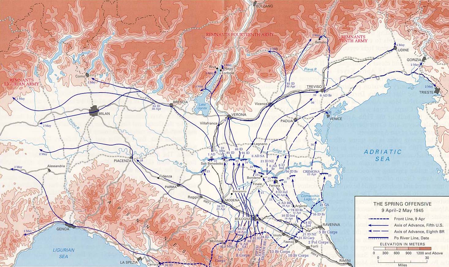
This paper deals with military geoscientific support for retreating German Armies in the Mediterranean – and in particular the Adriatic – Theatre during the Second World War. An understanding of the military situation in southern Europe at the end of the war can be easily gained from online sources and Tschudi (1960), Hillgruber and Hümmelchen (1978), Kinder and Hilgemann (2000) and Swanston and Swanston (2007), among others. As a response to the Allied Armistice with Italy on 8 September 1943, the Operational Zone of the Alpine foothills was established on 10 September 1943 by the German Reich (Stuhlpfarrer 1969). The Allied campaign in Italy consisted of operations from the invasion of Sicily in July 1943 until the surrender of the German Armed Forces in Italy in May 1945 (Swanston and Swanston 2007). The map of the Italian battle zone in Fig. 13.1 depicts the northern advance of Allied troops to the Gothic Line, one of the German defence lines crossing the Apennines (later called the Green Line). The spring 1945 offensive in Italy was the final Allied attack during the Italian campaign. The attack into the Lombardy Plain, which began on 6 April, ended on 2 May 1945 with the formal surrender of the German forces in Italy (Swanston and Swanston 2007).

Allied advance to the Gothic Line (centre) and gains to the north until 31 December 1944. (Modified from USMA 2020)
2 German Military Geologists Deployed to the Adriatic Theatre
This section deals with aspects of military geologic support for retreating German Armies in 1944 in the Balkans and on the Western Front in Italy until May 1945. In 1944, military geoscientific units of three different commands were active in the Adriatic Theatre: (1) military geology units of the Army High Command; (2) the Forschungsstaffel z.b.V.,Footnote 1 the research unit for special terrain evaluation that was deployed to the Counter-Intelligence Branch of the Armed Forces High Command in 1943 and assigned to the Military Office of the Reich Security Office in 1944; and (3) detachments of the SS Military Geology Corps affiliated to the Waffen-SS of the SS Main Operational Office.
2.1 Military Geology Teams of the Army High Command
From April 1941 to November 1943, the German Army High Command deployed a total of 40 Wehrgeologenstellen (military geology teams (MGT)) to Higher Engineer Officers of Armies, Army Groups and Fortification Engineers. During the course of the war, they served German Armies on the Western Front (in France, Holland and Belgium), in northern Europe (principally in Norway), at various times on the Eastern Front, in southeastern Europe (including Italy, Greece and Yugoslavia) and in North Africa. As explained in Häusler (2022), since November 1943, only a few months after the disastrous defeat of the German Armies in the battle of Kursk-Orel during Operation Zitadelle, eight new military geology teams were deployed to Army High Commands, High Commands of Army Groups, and Higher Engineer Officers of Fortress Inspectorates. Table 13.1 lists a few of the reports prepared by MGTs for the retreating German Armies in the battlefields of the Eastern Adriatic Sea, where five MGTs were deployed for service from 1943 to 1945.
2.2 Maps Prepared by the Forschungsstaffel
In 1941, the German Counter-Intelligence Service of the Armed Forces High Command founded a joint military-geoscientific reconnaissance team called Sonderkommando Dora (Special Command Dora) to update maps of the frontier between Libya and Chad in North Africa (Häusler 2018a, b). In 1943, this geoscientific research group of Special Command Dora was named Forschungsstaffel z.b.V. With a secret order issued by the Armed Forces Operations Staff (WFSt/1c Nr. 005639/44 g-K. dated 22 May 1944; Häusler 2007), the Counter-Intelligence Branch of the Armed Forces High Command was reorganised, and the Forschungsstaffel (still subordinate to Special Command Dora) was deployed to the Military Office of the Reich Security Office until the end of the war. The Forschungsstaffel was headed by geographer Dr. Otto Schulz-Kampfhenkel and supported German troops in the European theatres with terrain evaluation maps. From 1943 on, the civilian-military Forschungsstaffel increased in size to a total of about 170 scientists, predominantly geographers, plant sociologists, geologists, cartographers and geodesists. The unique core competence of the Forschungsstaffel in military geosciences lay in the integration of all literature and maps available from different institutions and local field studies supplemented with reconnaissance flights (Roscoe 1953; Häusler 2006, 2007). The results of the integrated surveys were printed as special maps of the Forschungsstaffel at scales varying from 1:50,000 to 1:200,000. These maps were not classified as terrain evaluation maps but served to assess the terrain according to military needs (Häusler 2011, 2018a).
From 1944 to the end of the war, the Forschungsstaffel consisted of three research commands (Fig. 13.2): Forschungskommando West (Western Research Command) covering central Germany, Forschungskommando Süd (Southern Research Command) covering the Adriatic Theatre, and Forschungskommando Ost (Eastern Research Command) covering greater Germany to the east, in addition to a few Einsatzgruppen (area control staffs) in Ukraine, northern Russia and Lapland. In this regard, Einsatzgruppe must not be confused with SS-Einsatzgruppen, the mobile killing squads of the Waffen-SS. In addition, a camouflage command mostly dealt with fortification camouflage along the Mediterranean and Atlantic coasts.

Terrain evaluation maps prepared by the Southern Research Command comprise maps at scales varying from 1:100,000 to 1:500,000 of northern Greece, southeastern Europe and central Europe. They all were printed during the last phase of hostilities from August 1944 to March 1945 (Table 13.2).
In more detail, area control staff belonging to the Southern Research Command supported German actions in the Adriatic Theatre in Greece (Saloniki), in Albania and Yugoslavia (e.g., Laibach-Istria, Dalmatia) in autumn 1944, and in early 1945 in northern Italy (e.g., Catull, Mendel). Specialist maps along the Austro-Hungarian border (e.g. tank map Fürstenfeld-Varaždin) were also prepared. The geoscientific staff of the Southern Research Command consisted of 25 specialists, two plant sociologists, two (up to three) geologists, two interpreters of stereo aerial photography, one hydrologist, one geodesist, one specialist for mountain roads, one map specialist, one tank specialist, ten cartographers, two specialists for Slavic languages and one copyist. Geländebeurteilung (terrain evaluation maps) were designed at a scale of 1:100,000, e.g. sheets 50 Padova, 51 Venezia, 64 Rovigo and 65 Adria, all of which were printed in March 1945 (Häusler 2007, 2019b; see Fig. 13.3).

Specialist maps of the North Italian and Yugoslavian Theatre at a scale of 1:100,000 dated February and March 1945, provided by the Forschungsstaffel prior to the Allied Spring Offensive, which started on 6 April 1945. (Adapted from Spring Offensive Italy 1945)
In addition, several maps of the northeast Adriatic coast, such as sheet 40 Palmanova (Fig. 13.4), 40A Goriza, 40B Postumia and 53A Trieste were printed as tank maps in February or March 1945. The newly developed method of terrain classification for the Palmanova tank map is described below.

The geographic information from German, Italian and Slovenian civilian offices was compiled for the Palmanova 1:100,000 scale tank map and then merged with the results from terrain reconnaissance and geoscientific information interpreted from stereo air photo pairs which covered the whole sheet. The legend included a table with areal and linear information and remarks for military use. Areal information comprised off-road trafficability, dense net of irrigation and drainage channels and forests.
Technical information on linear morphological features, such as slopes and dams and at certain points the material and bearing capacity of bridges, was noted. Off-road trafficability was described using three classes (Fig. 13.5). It was assessed as good where only a thin loam layer covered coarse fluvial deposits, as bad where wet coastal mud even caused problems for walking and as poor. Poor trafficability was further subdivided into three classes. Class 1 refers to coastal areas covered by thick layers of clay that caused trafficability problems during wet periods from October to April. Class 2 delineated the wet area between villages Cervignano and Codroipo, located in the centre and northwest of the sheet that was covered by boggy soil. Class 3 comprised coarse clastic fluvial beds that were intensively flooded from October to April but less so in January. In addition, the two-dimensional symbol for deciduous and coniferous forests was differentiated as brushwood or timber forest.

Legend for the 1:100,000 scale Palmanova tank map (Fig. 13.4) printed by the Forschungsstaffel in February 1945. The three trafficability classes are befahrbar, good going, bedingt oder zweifelhaft befahrbar, poor going; and unbefahrbar, bad going. (Used with permission from Dr. Sven Fuchs, Vienna, Austria)
The terrain evaluation map also included a table with remarks for military use. Special symbols for airborne landing, for example, became visible when the map was held against the light. Summing up, these specialist maps were designed not as terrain evaluation maps for specific purposes but as integrated geoscientific maps that had to be evaluated by the military user.
2.3 Construction Agency Todt (OT)
Despite the general use of military geologists for the paramilitary construction agency Organisation Todt (OT; named after its founder, the German engineer Dr. Fritz Todt) as, e.g., recorded in Norway (Häusler 2019a), it is unknown if and how many military geologists supported the fortification work of the OT along the three German defensive lines, the Cassino Line between Rome and Naples, the Green Line south of Bologna and the Blue Line west of Trieste (also called Alpine Line; Lemmes 2010; see Fig. 13.1). The OT did not become active in Italy on a regional scale until September 1943. Later on, the newly established Einsatzgruppe Italien of the OT was designated front zone, and the collective area was designated Front-OT. Within this area of highest construction priority, the OT had the status of a military organisation and its personnel became members of the Wehrmacht (Supreme Headquarters Allied Expeditionary Force, Counter-Intelligence Sub-Division 1945). OT was engaged in fortifications in the Operational Zone of the Adriatic Littoral, among others, between Venice and Rijeka and between Ravenna and Ancona. In addition, OT was responsible for bauxite mining in the Veneto and the construction of underground installations for armament factories near Bozen and Meran (Seidler 1987; Lemmes 2010).
2.4 Military Geologists of the Waffen-SS
With the start of the Second World War, tactical control of the Waffen-SS was exercised by the Oberkommando der Wehrmacht (High Command of the Armed Forces or OKW) with some units subordinated to Kommandostab Reichsführer-SS (Command Staff Reich Leader SS) directly under Heinrich Himmler’s control (Waffen-SS 2020). Some details on the organisation of MGTs in the Waffen-SS were published by Klietmann (1965), Tessin (1970, 1980), Kater (1974), Valente (2007), Schulte et al. (2014) and Kaienburg (2015). Archive documents and online sources tell of the various actions of two geologists in the Waffen-SS in the Adriatic Theatre: the German geologist Dr. Rolf Höhne (1908–1947) and the German geologist and mining engineer Dr. Ing. Hans Brand (1879–1959).Footnote 2
The SS-Wehrgeologen-Korps (SS-Military Geology Corps) was established in the Reich Security Office on 1 April 1941 by order of Reichs Leader SS Heinrich Himmler. Dr. Rolf Höhne was chief of the military geologists of the Waffen-SS, assigned to the Command Staff of the SS Main Operational Office. He headed the SS military geologists until the end of the war (Höhne 2020). On 24 May 1941, a military geology company was established consisting of one gallery construction company, two technical platoons for water supply, one drilling platoon and a geological equipment park (Kaienburg 2015). From 18 June 1941 onwards, this company was probably termed 1. Wehrgeologen-Kompanie (first military geology company) and was based in the SS barracks in Oranienburg near Berlin. It was reorganised on 15 November 1941 into a battalion (Wehrgeologenbataillon 2020). There is evidence that in January 1942, the Military Geology Branch of the Kommando-Stab RF-SS im SS-Führungshauptamt (Command Staff of Reich Leader SS) at the SS Main Operational Office consisted of three SS-Wehrgeologen-Kompanien (military geology companies) and four SS-Wehrgeologie-Sondergruppen (military geology groups) (Uwe Kleinert, personal communication, 2019). Due to the absence of documents, the structure of the entire SS military geology department during the war is unclear. In April 1941, presumably both the SS-Military Geology Corps (with its military geology companies) and the Technical Military Geology of the Technical Office were subordinate to Office I of the SS Main Operational Office.
According to Klietmann (1965), the military geology companies of the SS-Military Geology Corps were deployed to SS brigades and SS divisions at the front. There is documentary evidence indicating their involvement with several SS military geology battalions and companies: SS-Wehrgeologen-Bataillon (mot) (a motorised military geology battalion) in November 1941, SS-Wehrgeologen-Bataillon 101 (SS-Military Geology Battalion 101) and SS-Wehrgeologen-Kompanie 105 (SS-Military Geology Company 105), all active in 1943. From 15 September 1944 in northern Italy, the Wehrgeologen-Abteilung 500 (SS-Military Geology Battalion 500) was installed in addition to the Motorized Military Geology Battalion (mot). The majority of privates in these military geology battalions were engineers; only company commanders were graduate geologists or mining engineers (Häusler 1995a).
About ten SS military geologists were deployed to military geology companies and battalions that were headed by Dr. Höhne, who had studied geology and graduated from Greifswald University in 1933. In 1939, at a time when Prof. Dr. Ernst Kraus headed the Technical Military Geology of the Army High Command, Höhne headed the subdivision “Referat Xc” of the tenth Group of Branch 5, the Engineer and Railway Engineer Branch of the Army Ordnance Office (Häusler and Willig 2000). He joined the SS and became a member of Himmler’s personal staff. For a short time, Höhne headed the Department for Geology and Mineralogy of the Forschungs- und Lehrgemeinschaft: Das Ahnenerbe (the Society for Research and Teaching of Ancestral Heritage) affiliated to the Personal Staff of the Reich Leader SS. In April 1941, Höhne was styled both Kommandogeologe (commanding geologist) of the Command Staff Reich Leader SS and Chefgeologe (chief geologist) of the Waffen-SS. It was presumably Obersturmbannführer (lieutenant colonel) Dr. Rudolf Höhne who commanded the Motorized Military Geology Battalion (mot) from May 1942 until 1945 (Kater 1974). Compamies of the Motorized Military Geology Battalio (mot) were deployed to different theaters of war.
Among others, the fourth SS Company, headed by the Austrian mineralogist/geologist Dr. Johann Robitsch, was deployed to the east in 1943 and during the last months of the war to northern Italy (Häusler 1995b). Another company was presumably first deployed for construction work on the French coast in Normandy and then supported the reinforcement of defensive positions in northern Italy. It is very likely that in June 1942 a unit of Höhne’s Military Geology Battalion was deployed to the SS Division Prinz Eugen in the Eastern Theatre, where a Bakteriologisches Feldlaboratorium (a hydrologic field laboratory) was used for investigations of groundwater for the medical company of this SS division. Furthermore, it cannot be ruled out that this SS Motorized Military Geology Battalion (mot) was in closer contact with the Karstjäger-Bataillon of the SS Division Prinz Eugen (see below).
The SS Military Geology Battalion 500 consisted of four companies that were deployed to different theatres of war. Each of these companies consisted of about 300 men and was headed by a graduate officer. Each company included one platoon each for Brunnenbauzug (well construction), Bergbauzug (mining) and Pionierzug (engineering) and was also trained for combat. In April 1944, the Motorized Military Geology Battalion (mot) had a strength of 12 officers, 50 non-commissioned officers and 580 men. Many of the officers were graduate specialists (Uwe Kleinert, personal communication, 2019). In September 1944, SS MGTs of the SS-Military Geology Battalion were deployed to Kommandostab Voralpen, the Operational Zone of the Alpine foothills in northern Italy, for the fortification of the Blue Line (Fig. 13.1), where they remained until the surrender on 2 May 1945. Their orders for work in the southern Alpine foothills between Lake Garda and the Etsch (Adige) Valley and from Rovereto to Trento, among other locations, comprised the investigation of anti-tank obstacles, the preparation of blasting road tunnels east and west of Lake Garda, the assessment of the load-bearing capacity of natural caverns (Häusler 1995a, b) and reinforcing fortifications along the former Alpine Wall (Vallo Alpino).
The Waffen-SS used special symbols from the military geology services in their tactical maps. Presumably, these tactical signs were planned in an early stage of establishing geology units of the SS before the military geology battalions were formed because the symbols refer to the deployment of geology groups to the staff of brigades, divisions, corps and armies, which is not documented. However, due to orders on the special geophysical investigations of SS military units (Klietmann 1965), the use of tactical symbols for special geologic cars, including geophysical and drilling equipment, is very likely.
Due to Himmler’s interest in occultism, emphasis was laid on dowsing research, among other research areas, for groundwater investigations by SS military geologists. For this purpose, special training courses were organised by Das Ahnenerbe. The Department for Applied Geology of Das Ahnenerbe was headed by the Munich physician and grammar school teacher Dr. Josef Wimmer, who on 30 October 1940 provided a report on a position paper of the Reich Association for Dowsing dated 6 October 1938 (Wimmer 1940). In this report, Wimmer (1940, p. 4) argued: ‘Today the situation has been reached, whereupon the physical side of the problem of dowsing can in general be seen as solved.’
In late 1942, it was planned that each SS MGT should be supported by its own dowser, and it is reported that three dowsers were stationed with a division of the Waffen-SS in Belgrade by the end of 1942 (Kater 1974). Prokop and Wimmer (1985, Fig. 9) published an example of a certificate from Das Ahnenerbe for Rutengänger im Hauptberuf (professional dowsing) for Mr. Samuel Otte, who passed a special training course for dowsing in December 1943. Häusler (1986) emphasised that the Inspector General for Water and Energy, as well as other German governmental offices, prohibited dowsing within their spheres of influence with an order dated 22 January 1943, and in 1944, the use of both the divining rod and dowsing certificates was prohibited by governmental offices of the German Reich as well as by the central office of the OT. Nevertheless, in September 1944, geologic dowsing was proposed by Wimmer (as head of the Department of Applied Geology of Das Ahnenerbe) for hydrocarbons in the Province of Venice.
3 The SS-Karstwehr-Bataillon
This section briefly introduces the beginnings of scientific research on karst and caves within Das Ahnenerbe. In 1944, investigations on caves became important for the storage of cultural property and the construction of underground installations for branches of the war industry, but these are not referred to here. Among other departments, the Abteilung für Karst- und Höhlenkunde (the Department for Research on Karst and Caves) was founded in October 1938. This department was first headed by Dr. Walther Steinhäuser and comprised, among others, branches for general karst research, karst geology and military geology (Kater 1974; see also Häusler 1995b). In 1939, Steinhäuser was replaced by Dr. Ing. Hans Brand (Klee 2014; Reitzenstein 2014). In August 1940, the name of this department was changed to Forschungsstätte für Karst- und Höhlenkunde in der Forschungs- und Lehrgemeinschaft Das Ahnenerbe (Research Institution on Karst and Speleology). From 1942 until 1944, Colonel Robert Ritter von Srbik from the Geologic Institute of Innsbruck University was contracted for the preparation of a survey of caves in Vorarlberg, western Austria, and the Tyrol. In February 1943, Brand also provided maps of caves in the Dinaric Alps, the mountain range in Southern and Southeastern Europe, at scales of 1:75,000 and 1:100,000.
The Karstwehrversuchstruppe, a special unit for fighting in karstified areas, was founded by an order dated 3 July 1942 and was renamed Karstjägerbataillon (Karst Hunter) in winter 1942/1943 (Tessin 1970). It was based in Pottenstein, Bavaria, and the facility was built with forced labourers from an outpost of the Flossenbürg concentration camp. On 10 July 1942, the SS Main Operational Office established a Karstwehrbataillon, which was renamed the SS-Karstwehr-Bataillon on 15 November 1942. On 2 June 1944, Himmler ordered the foundation of an Ahnenerbe research institution in the karstified area of Carniola (German: Krain; the historical region that comprised parts of present-day Slovenia) and the Operational Zone of the Adriatic Littoral (Knolle 2012). On 31 August 1944, Himmler, in his function as Commander of the Replacement Army and Chief of Army Equipment, ordered the installation of the SS-Fortifikationsstelle zur Erkundung der italienischen Grenzwehranlagen (fortification office) for the reconnaissance of fortification positions in the Operational Zone of the Alpine foothills along the Italian border. With the certification of Karl Wolff, General of the Waffen-SS and the highest-ranking SS and police leader in Italy, on 1 August 1944, Standartenführer (colonel) Dr. Ing. Hans Brand was charged with the installation of this office and, in addition, with the installation of a research establishment on karst and caves. At that time, the former Karstjäger-Bataillon was reorganised (Tessin 1970) and in February 1945 was renamed as the 24. Waffen-Gebirgs-(Karstjäger-) Division der SS. From November 1944 onwards, this Division fought partisans in western Slovenia and Julian Venetia, and war crimes are cited in Blood (2006) and Kaltenegger (2008).
4 Summary and Discussion
After the end of hostilities in North Africa (in May 1943), the major retreat of the German Armies in eastern Europe (in August 1943)and the armistice agreement between the Kingdom of Italy, the United States of America and Great Britain (on 8 September 1943), the war in Europe focussed more on the Adriatic Theatre and, in particular, on Italy. This paper has focussed on the geoscientific support for the German Armies and their fortress engineers provided by five different agencies: (1) military geology units of the Army High Command; (2) the Forschungsstaffel z.b.V. of the Armed Forces High Command, later on deployed to the Military Office of the Reich Security Office; (3) the Organisation Todt, (4) the Wehrgeologen-Korps of the Waffen-SS and (5) the SS-Karstjäger-Bataillon.
In contrast to thousands of written geologic reports that were provided by the military geology units of the Army High Command for the use of attacking German Armies in the east or occupied countries, only a few documents verify the geologic support provided by MGTs during the retreat of the German Armies during the last two years of hostilities in the Adriatic Theatre. These documents are housed in the Heringen Collection, stored in the Bundesarchiv/Militärarchiv in Freiburg im Breisgau.
After its establishment in early 1943, the Forschungsstaffel provided specialist maps for the terrain evaluation of potential northern Italian and Yugoslavian battlefields at scales 1:100,000 and 1:200,000. These maps were of very high quality. However, it cannot be ruled out that specialist maps that were printed in February and March 1945 were distributed too late for tactical use by the retreating German Army. It should be pointed out, however, that the written reports prepared by German military geology teams deployed to Armies and Fortress Engineers of the Army High Command were of immediate use for tactical decisions as well as for the supply of troops and the construction of defensive positions and fortifications. The military expertise and technical quality of printing of military-geoscientific maps prepared by the Forschungsstaffel some 75 years ago are still unique and are comparable to digital maps based on the North Atlantic Treaty Organization’s (NATO’s) software on the recognised environmental picture for the combination of geospatial, meteorological and oceanographic data, as developed by the Defence Geospatial Information Working Group (Kresse and Danko 2012).
At present, archive documents verifying that German military geologists supported the construction work of the OT along defensive lines in the northern Apennines are missing. Regarding the efficiency of this German construction agency with respect to the construction of defensive works at the Westwall in Norway (Häusler 1995a, 2019a), it is very likely that the OT also employed geologists for sub-surface investigations on defensive positions and fortifications along the planned defensive lines across the Apennines (Seidler 1987; see Fig. 13.1, this paper). Additional efforts of the OT, and presumably of military geologists in Italy, were along the Ligurian coast, in particular at La Spezia and Genoa, as well as around Rome, Lazio, southern Tuscany and southwest Umbria (Supreme Headquarters Allied Expeditionary Force Counter-Intelligence Sub-Division 1945). Valente (2007) reported on the deployment of four military geology companies of the Waffen-SS for OT construction work in Trentino-Alto Adige between Rovereto and Riva. Due to known efforts of the OT on the southern flank of the Alps, public newspapers, magazine accounts and secret intelligence reports alike seriously explored a “national redoubt” concept for an area from southern Bavaria across the Austrian Alps to northern Italy as a “fortress that never was” (Starr 1965; Minott 1967; Seidler 1987).
In contrast to the military geology units of the Army High Command that provided written reports to the Higher Engineers of the Army High Commands as well as to the leading geologist of the Army High Command, the SS military geologists regularly reported on their duties to the SS Military Geology Corps in Berlin. In September 1944, companies of the SS Military Geology Battalion 500 supported the reinforcement of older fortifications along the Blue Line (Alpine Line in Fig. 13.1) in northern Italy, and Valente (2007) provided personal details on the SS military geologists in this battalion.
Founded as a research department on karst and caves in Europe in 1938 by the SS Society for Research and Teaching of Ancestral Heritage, Das Ahnenerbe, the SS-Karstjäger Bataillon, became a combat unit with a battalion status in 1942 and was involved in war crimes during the last months of the Second World War.
Notes
- 1.
‘z.b.V.’ is the abbreviation for ‘zur besonderen Verwendung’, which means for special utilisation by high military commands.
- 2.
Dr. Ing. Hans Brand (1879–1959) must not be mistaken for the German military geologist Dr. Erich Brand (1914–2011), see Häusler (1995b).
References
Blood PW (2006) Hitler’s bandit hunters: The SS and the Nazi occupation of Europe, 401. Potomac Books, Washington DC
Häusler H (1986) Die “historische” Rolle der Wünschelrute für Aufgaben der Angewandten Geologie. Mitteilungen der Gesellschaft der Geologie- und Bergbaustudenten 33:265-286
Häusler H. (1995a) Die Wehrgeologie im Rahmen der Deutschen Wehrmacht und Kriegswirtschaft. Teil 1: Entwicklung und Organisation. Informationen des Militärischen Geo-Dienstes vol 47. Bundesministerium für Landesverteidigung, Wien
Häusler H (1995b) Die Wehrgeologie im Rahmen der Deutschen Wehrmacht und Kriegswirtschaft. Teil 2: Verzeichnis der Wehrgeologen. Informationen des Militärischen Geo-Dienstes vol 48. Bundesministerium für Landesverteidigung, Wien
Häusler H (2000) Deployment and role of military geology teams in the German army 1941–45. In: Rose EPF, Nathanail CP (eds) Geology and warfare: examples of the influence of terrain and geologists on military operations. The Geological Society, London, p 159-175
Häusler H (2006) Historic maps of terrain evaluation. In: Mang R, Häusler H (eds) International Handbook Military Geography. Bundesministerium für Landesverteidigung, Wien, p 257-271
Häusler H (2007) Forschungsstaffel z.b.V. – Eine Sondereinheit zur militärgeografischen Beurteilung des Geländes im 2. Weltkrieg. MILGEO 21. Bundesministerium für Landesverteidigung, Wien
Häusler H (2011) The “Forschungsstaffel z.b.V.”, a special geoscientific unit of the German counter military intelligence service during the Second World War. In: Häusler H, Mang R (eds) International Handbook Military Geography (Proceedings of the 8th International Conference on Military Geosciences, June 15–19, 2009), 2:276-286. Bundesministerium für Landesverteidigung und Sport, Wien
Häusler H (2018a) Geographen im Zweiten Weltkrieg: Die “Forschungsstaffel z.b.V.”: Nutzung der Potenziale des Georaumes für Militärische Zwecke. Mitteilungen der Österreichischen Geographischen Gesellschaft 160:9-56. https://doi.org/10.1553/moegg160s9
Häusler H (2018b) Sonderkommando Dora – Special military geoscientific unit of the German counter-intelligence service in North Africa 1942. Scientia Militaria, South African Journal of Military Studies 46(1):37-57. https://doi.org/10.5787/46-1-1224
Häusler H (2019a) The northern Atlantic Wall: German engineering geology work in Norway during World War II. In: Rose EPF, Ehlen J, Lawrence UL (eds) Military aspects of geology: fortification, excavation and terrain evaluation. Special Publication 473. The Geological Society, London, p 83-108. https://doi.org/10.1144/SP473-16-061
Häusler H (2019b German military specialist maps of the north Italian theatre of war 1945. The 13th International Conference on Military Geosciences, Peace follows war: geosciences, territorial impacts and post-conflict reconstruction, Padova 24-28 June 2019, Abstract book. Societá Geologica Italiana, Roma, p 46. https://doi.org/10.3301/ABSGI.2019.03
Häusler H (2022) German Military Geography and Geology at the Eastern Front 1941-1945. In: Bondesan A, Ehlen J (eds) Military Geoscience: A multifaceted approach to the study of warfare, 978-3-030-79259-6, 490182_1
Häusler H, Willig D. (2000) Development of military geology in the German Wehrmacht 1939-45. In: Rose EPF, Nathanail CP (eds) Geology and Warfare: examples of the influence of terrain and geologists on military operations. The Geological Society, London, p 141-158
Hillgruber A, Hümmelchen G (1978) Chronik des Zweiten Weltkrieges – Kalendarium militärischer und politischer Ereignisse 1939–1945. Droste-Verlag, Düsseldorf
Höhne R (2020) https://de.wikipedia.org/wiki/Rolf_Höhne. Accessed 25 May 2020
Kaienburg H (2015) Der Militär- und Wirtschaftsstandort der SS im KZ-Standort Sachsenhausen-Oranienburg. Schnittpunkt von KZ-System, Waffen-SS und Judenmord. Schriftenreihe der Stiftung Brandenburgische Gedenkstätten, vol 16. Metropol Verlag, Berlin
Kaltenegger R (2008) Totenkopf & Edelweiß. General Artur Phleps und die südosteuropäischen Gebirgsverbände der Waffen-SS im Partisanenkampf auf dem Balkan 1942–1945. Ares Verlag, Graz
Kater MH (1974) Das “Ahnenerbe” der SS 1935-1945. Ein Beitrag zur Kulturpolitik des Dritten Reiches. Deutsche Verlags-Anstalt, Stuttgart
Kinder H, Hilgemann W (2000) dtv-Atlas Weltgeschichte. Deutscher Taschenbuch Verlag, München
Klietmann K-G (1965) Die Waffen-SS, eine Dokumentation. Verlag Der Freiwillige GMBH, Osnabrück
Klee E (2014) Das Personenlexikon zum Dritten Reich. Wer war was vor und nach 1945, 4. Auflage. Fischer Taschenbuch Verlag, Frankfurt am Main
Knolle F (2012) Materialien zur Geschichte der deutschen Höhlenkunde im Schatten des “Dritten Reiches”. Abhandlungen der Arbeitsgemeinschaft für Karstkunde in Niedersachsen e.V., 5:1-66. Eigenverlag der Arbeitsgemeinschaft für Karstkunde in Niedersachsen e.V. (Digitale Neuauflage des Heftes aus dem Jahr 1987), Osterode https://www.karstwanderweg.de/publika/argekaha/5/1-66/index.htm. Accessed 25 May 2020
Kresse W, Danko D (2012) Springer handbook of geographic information. Springer, Berlin
Lemmes F (2010) Zwangsarbeit im besetzten Europa. Die Organisation Todt in Frankreich und Italien, 1940–1945. In: Heusler A, Spoerer M, Trischler H (eds) Rüstung und Kriegswirtschaft im “Dritten Reich”. Schriftenreihe der BMW Group – Konzernarchiv 3. Oldenbourg Wissenschaftsverlag GmbH, München, p 219-252
Minott RG (1967) Top Secret. Hitlers Alpenfestung. Tatsachenbericht über einen Mythos. Rowohlt Taschenbuch Verlag, Reibek/Hamburg
Prokop O, Wimmer W (1985) Wünschelrute, Erdstrahlen, Radiästhesie. Die okkulten Strahlenfühlungslehren im Lichte der Wissenschaft. 3. völlig neu bearbeitete Auflage. Ferdinand Enke, Stuttgart
Reitzenstein J (2014) Himmlers Forscher. Wehrwissenschaft und Medizinverbrechen im »Ahnenerbe« der SS. Ferdinand Schöningh, Paderborn
Roscoe JH (1953) Photogrammetry. In: The Committee on Geophysics and Geography Research and Development Board (ed) Selected papers on photogeology and photo interpretation. Directorate of Intelligence, US Air Force, Washington DC
Schulte JE, Lieb P, Wegner B (2014) Die Waffen-SS. Neue Forschungen. Krieg in der Geschichte (KriG) vol 74. Ferdinand Schöningh, Paderborn
Seidler F (1987) Die Organisation Todt. Bauen für Staat und Wehrmacht 1938-1945. Bernard and Graefe, Koblenz
Spring Offensive Italy 1945. Wikimedia Commons. http://www.army.mil/cmh-pg/brochures/po/map2.JPG
Starr CG (1965) The Fortress that never was: The myth of Hitler’s Bavarian stronghold. The Journal of American History, 52(2):411-412
Stuhlpfarrer K (1969) Die Operationszonen „Alpenvorland“ und Adriatisches Küstenland“ 1943-1945. Publikationen des Österreichischen Instituts für Zeitgeschichte und des Instituts für Zeitgeschichte der Universität Wien, vol 7. Brüder Hollinek, Wien
Supreme Headquarters Allied Expeditionary Force, Counter-Intelligenc Sub-Division. (1945) Handbook of the Organisation Todt (OT). MIRS/MR-OT/5/45, 36. Military Intelligence Research Section, London https://archive.org/stream/HandbookOfTheOrganisationTODTOTUK1945/Handbook-of-the-organisation-TODT-O-T-UK-1945_djvu.txt. Accessed 25 May 2020
Swanston O, Swanston M (2007) The historical atlas of World War II. Cartographica Press Ltd./Chartwell Books, Inc., London
Tessin G (1970). Verbände und Truppen der deutschen Wehrmacht und Waffen-SS im Zweiten Weltkrieg 1939-1945. 4. Band, Die Landstreitkräfte. Biblio Verlag, Osnabrück, p 15-30
Tessin G (1980) Verbände und Truppen der deutschen Wehrmacht und Waffen-SS im Zweiten Weltkrieg 1939-1945, 14 vols. Biblio Verlag, Osnabrück
Tschudi E (1960) Die militärischen Operationen in Europa 1939-1945. Karte 1:5,000,000. Kümmerly and Frey, Bern
US Military Academy (USMA) (2020) Maps of Allied Offensives: Allied Offensives in Northern Italy (June 5 - December 31, 1944). https://www.jewishvirtuallibrary.org/map-of-allied-offensives-in-northern-italy-june-december-1944. Accessed 20 May 2020
Valente L (2007) I geologi di Himmler. L’SS-Wehrgeologen-Bataillon 500 tra Veneto e Trentino: dalla rappesaglia della Laita (Tretto di Schio, 30 novembre 1944) all’ipotesi Pedescala. Nuova serie, vol. 63. Cierre-Istrevi, Verona
Waffen-SS (2020). https://en.wikipedia.org/wiki/Waffen-SS. Accessed 25 May 2020
Wehrgeologenbataillon (2020) https://www.forum-der-wehrmacht.de/index.php?thread/3203-ss-wehrgeologen-btl-mot-500/. Accessed 25 May 2020
Wimmer J (1940) Zur Denkschrift des Reichsverbandes für das Wünschelrutenwesen (vom 6.10.1938) und zum Bericht des S.D. (ohne Datum). Manuscript, 12 Seiten, nach „Ahnenerbe: Documents from Nazi Germany, 1936-1945“ verfasst am 30. Oktober 1940. https://digitalcommons.ursinus.edu/dowsing/30. Accessed 25 May 2020
Acknowledgements
I thank Univ. Prof. Dr. Johann Robitsch (23.11.1912–10.4.1990) for providing information on SS military geology. Thanks are due to the support of the German Federal Archives, Militärarchiv in Freiburg im Breisgau and the Museum für Historische Wehrtechnik in Röthenbach an der Pegnitz, Bavaria. The author acknowledges Univ. Prof. Dr. Sven Fuchs, Vienna, Austria, for providing the maps prepared by the Forschungsstaffel and Uwe Kleinert, Berlin, for additional information on the Military Geology Corps of the Waffen-SS.
Author information
Authors and Affiliations
Corresponding author
Editor information
Editors and Affiliations
Rights and permissions
Copyright information
© 2022 Springer Nature Switzerland AG
About this chapter

Cite this chapter
Häusler, H. (2022). The Use of German Military Geology in the Adriatic Theatre 1943–1945. In: Bondesan, A., Ehlen, J. (eds) Military Geoscience: A Multifaceted Approach to the Study of Warfare. Advances in Military Geosciences. Springer, Cham. https://doi.org/10.1007/978-3-030-79260-2_13
Download citation
DOI: https://doi.org/10.1007/978-3-030-79260-2_13
Published:
Publisher Name: Springer, Cham
Print ISBN: 978-3-030-79259-6
Online ISBN: 978-3-030-79260-2
eBook Packages: Earth and Environmental ScienceEarth and Environmental Science (R0)