
Abstract
This paper investigates the methods used in city planning of ancient Chiang Mai, which was founded in CE 1296 by King Mangrai. According to the Chiang Mai Chronicle, King Mangrai invited King Ram Khamhaeng of Sukhothai and King Ngam Muang of Phayao to the new site and consulted them on the suitability of the location and the city plan. Together they observed seven good omens for the site, for example, mountain in the west, river in the east, water reservoir in the northeast, and fertile soil for farming. King Mangrai then decided to establish the Lanna capital city at this site and name Chiang Mai. He spent four years planning, including the determination of the cardinal directions. The city plan chosen was a square formed by moats and city walls that faced the cardinal directions. The starting date and time of construction were chosen according to astrological calculations based on the position of the Sun, the Moon, and the five classical planets. Work began at the Sri Bhumi Corner in the northeast, which was considered the most auspicious of the four corners. The city walls, the observation towers, the gates, the moats, the royal residences, and the Throne Hall were all built at the same time. Most of the work was completed within four months. Unfortunately, written records on the methods used in the city planning do not exist. Nonetheless, the results of this investigation suggest that the Chiang Mai city plan was influenced by the Vaastu Shastra, which is ancient Hindu knowledge about architecture.
Access provided by Autonomous University of Puebla. Download chapter PDF
1 Introduction
In many ancient kingdoms of Thailand, architectural forms including city and temple planning were influenced by Indian culture transmitted throughout the era of the Dvaravati and the Khmer Empire. The structural principles of Indian architecture propagated to Southeast Asia through migration, trade, and the missionary activities of Buddhism (Theravada and Mahayana), as well as Hinduism (Shaivism and Vaishnavism). Clear evidence of Indian influence in Thailand can be seen at the Sri Thep Ancient City (currently located in Phetchabun province), which was an ancient city during the Dvaravati era (sixth–eleventh centuries) when Buddhism and Hinduism flourished (O’Reilly, 2007).
During the thirteenth century, the most powerful king of the Khmer empire was King Jayavarman VII (CE 1181–1219) who regained the Khmer’s independence from the Cham and founded Angkor Thom to be a new capital. The design of city and temple in Khmer architecture followed the knowledge of Vedic architecture named Vaastu Shastra as a blueprint, incorporating the belief in deities, planets of the eight directions, and buildings oriented to astronomy (Chandler, 1993). King Jayavarman VII also adopted Mahayana Buddhism instead of Hinduism, which was reflected in the infamous Bayon temple. Furthermore, he built several religious buildings resembling the Bayon art, a new art which was well-received throughout the Thai regimes in the northeast and southeast, and in central Thailand provinces such as Phetchaburi, Kanchanaburi, and Sukhothai. The influence of Indian architecture from central Thailand had propagated to the northern part of Thailand and reached the Lanna Kingdom when Queen Jamadevi brought nearly ten thousand followers, including monks, philosophers, and artisans from the Lavo Kingdom (Lopburi province) to found the city of Hariphunchai (now in Lamphun province). The Queen turned Hariphunchai into a resourceful city for arts and culture. Later, she founded Khelang Nakorn (Lampang province) to be another main city. The ancient Mon language was also scripted on a stone inscription during the Hariphunchai period. Thus, Queen Jamadevi can be regarded as a propagator of Indian culture from the Dvaravadi and Khmer regimes to land in the northern part of Thailand. Later, in CE 1281 the Hariphunchai Kingdom became part of the Lanna Kingdom (Ongsakul, 2005). Ancient kingdoms in the land of present-day Thailand that were ruled by the Khmer adopted Khmer city planning, with the city laid out in square or rectangular shapes, similar to the plan of Angkor Thom. Angkor Thom featured a square plan, surrounded by walls and moats, with the Prasat Bayon (temple) at the center.
During King Ramkhamhaeng’s reign, Sukhothai also had the same Khmer ancient city planning features: a rectangular plan bounded by walls and moats. In the center of the city was a religious building that symbolized the center of the Universe. This differed from the previous Dvaravati Culture where the plan had an irregular shape similar to a conch (Shanka) or a sphere, as seen in U-thong, Lavo, Hariphunchai and Khelang Nakorn. Other examples of Khmer city plans found in Thailand are Mueng Sing and Mueng Phimai. Mueng Sing’s plan is almost a square shape with Prasat Mueng Sing located at its center. Mueng Phimai has a rectangular plan enclosed by walls and moats. There was a gate on each of the four sides, and the Moon River flowed through the city from north to east. In the center was Prasat Hin Phimai (Chaturawong, 2017).
According to the Chiang Mai Chronicle (Wichienkaeo and Wyatt, 1995), initially King Mangrai had planned to build a city in a square shape with the sides 2000 wa (~ 3.2 kilometers) long, which would have been the same size as Angkor Thom. However, he was cautioned by King Ram Khamhaeng regarding homeland security, and so decided to reduce the size. Although Lanna people were migrants from southern China, there was no city planning that used Chinese Feng Shui principles. In general, Feng Shui and Vaastu Shastra were similar, except that the orientation of the main entrance was different (Saran and Shirodkar, 2017).
The reason for choosing Vaastu Shastra rather than Feng Shui principles could have been because India and the Lanna Kingdom were at the same latitude, and therefore the Lanna Kingdom was geographically more similar to India than to China. Also, the seasons, the monsoon directions, and religious beliefs were more similar. Furthermore, the influence of the powerful Khmer Empire propagated through Sukhothai or through Lavo to Hariphunchai could have been additional reasons for adopting Vaastu Shastra in Chiang Mai city planning. In this chapter, we will report on how closely Chiang Mai city planning corresponds to the Vaastu principle.
2 City Planning of Ancient Chiang Mai
Chiang Mai (the current name), the capital city of the Lanna Kingdom, was founded by King Mangrai the Great, the first Lanna king, in CE 1296. Chiang Mai was given the name Nop Buri Sri Nakorn Ping, and was situated in the upper northern part of Thailand between the base of Suthep Mountain and the basin on the right of the Ping River. The Lanna people inherited a fertile land capable of producing high-yield agricultural crops. They also had their own language, scripts, customs, traditions and culture. The history of the Lanna Kingdom can be divided into three periods. The first period was when Lanna was an independent state (the Mangrai Dynasty in CE 1296–1558). The second period was when Lanna was under Burmese rule, from 1558 to 1774, and the third period was when Lanna became a state of Siam (a Siamese tributary during the Chet Ton Dynasty from 1782 to 1939). In 1932, Khana Ratsadon (meaning ‘People’s Party’) changed the system of Government in Thailand. The City Governor’s position was revoked, and Chiang Mai became a province under the central administration.
Information about Chiang Mai city planning in this research was gathered from the remaining primary sources such as Pubsa (mulberry paper), Bailan (palm-leaves) and stone inscriptions. These sources were documented after the founding of the city, as described in detail in Sub-section 13.2.1. This research study is based on information that was compiled from all primary sources and published as The Chiang Mai Chronicle (CMC) by Wichienkaeo and Wyatt (1995) and History of Lan Na by Ongsakul (2005). These books provide valuable details about the city’s founding, as described in Sub-sections 13.2.2 and 13.2.3. CMC is based on the Chiang Mai chronicle that translated Lanna Tham scripts from authentic palm-leaves and were corrected by Dr Hans Penth (1937–2009), and are known as ‘Hans Penth version’. The original palm-leaves script had been organized into eight bundles of leaves (the maximum one with 26 sheets), each with multiple sheets that were written on both sides of the leaf. To refer to Dr Penth’s collection, we write CMC-a.bc, where a indicates the bundle number (1-8), b is the sheet number (01-26), and c is the V (front) or the R (back) of the sheet. For example, the code CMC-2.13V refers to the 2nd bundle, the 13th sheet, and the front of the sheet.
2.1 Overview of the Historical Records
The study and writing of Lanna history started about six hundred years ago when local scholars and monks began composing chronicles on palm-leaf manuscripts. Today, the chronicles still retain a strong foothold in local popular consciousness, and they are a rich source of information for modern historians.
The Wat Phra Yean stele, inscribed in CE 1370, is considered the region’s oldest stone inscription. Another stele of dynastic succession, the stone inscription in Fak Kham script, was inscribed in 1411 and the Wat Chiang Man stele, was inscribed in 1581.
The earliest chronicles, written in the fifteenth and sixteenth centuries are now generally considered classical chronicles. Important texts from this period, including the Mulasasana, Camadevivamsa and Jinakalamali chronicles, became the model for all others over the following centuries.
The pioneer of the modern study of history in Thailand was Phraya Prachakitkorachak (Chaem Bunnag), who produced a renowned study of Lanna, the Yonok Chronicle (Ongsakul, 2005).
2.2 The Founding of Chiang Mai
According to the Lanna inscriptions and historical evidence, they are all in agreement that King Mangrai obeyed the auspicious time to move into the site on Thursday of the 7th Lanna lunar month (equivalent to the 5th Thai lunar month), waxing moon the 8th day, 654 Culasakaraj (CS) (CMC-2.10R). This was regarded as the building date of his temporary royal residence. He used his residence, which was on the northeast of the Chiang Mai City plan (today it is Wat Chiang Man), to work on the planning of the city.
According to CMC-2.10R, King Mangrai gave an order to begin plowing the site from his sleeping chamber to the northeastern corner, or the Sri Bhumi corner. Beyond the Sri Bhumi corner, there was a large lake named Nhong Kiew (or Nhong Bua Jed Gor) that connected to the Mae Kha canal. King Mangrai was very satisfied because there would be plenty of water for elephants, horses, and castles to shower and drink. He then asked carpenters to prepare wooden logs for building an elephant nursery, horse pens, observation towers, and city gates, hoping to build a grand city.
As King Mangrai and his two royal friends—King Ruang of Sukhothai (King Ram Khamhaeng) and King Ngam Muang of Phugamyao (present-day Phayao)—entered the site, they saw a large albino mouse along with its four followers ran from the temporary royal residence towards the east and then into a hole under a Ficus lacore tree (the same family as the Banyan tree, which was considered an auspicious tree). They were all very pleased to witness this event, and brought offerings to worship the mouse and the tree. They then designated the tree to be the city guardian, and it remained ever since (CMC-2.11V).
Afterwards, the city was planned to be 900 wa in width and 1000 wa in length (i.e. a rectangular shape) (CMC-2.11R). The laborers were divided into two groups. The first group, of 50,000 people, would build royal residences, royal halls, elephant nurseries and horse pens. The second group, of 40,000 people, would build the city walls by digging moats on all four sides and building up the soil to form the walls around the perimeter (CMC-2.13V).
Based on the CMC it took four years of city planning, then the groundbreaking day was the Full Moon, the 8th Lanna lunar month, 658 CS (CMC-2.13V). However, according to the Wat Chiang Man inscription (Database of Inscriptions in Thailand | Wat Chiang Man Stale), it was the waxing moon the 8th day, the 8th Lanna lunar month, 658 CS. It took four months to complete the construction. Afterwards, the city hosted a festive celebration for three days and three nights with its name being given as Nop Buri Sri Nakorn Ping.
2.3 Chiang Mai City Walls and Gates
The CMC indicates that after the completion of all four city walls, five city gates were built (CMC-2.13V). However, there is no record of the name of the gate in each direction, therefore it cannot be certain whether the current names were the original names. Presently, the gate in the north is called Pratu Chang Puenk. The western gate is called Pratu Suan Dok. The eastern gate is Pratu Thapae (initially named Pratu Chiang Ruek). In the south, there are two gates: Pratu Chiang Mai (the back gate) and Pratu Suan Prung. Pratu Suan Prung, previously called Suan Re, was built in the reign of King Samfangkaen (the eighth King in Mangrai Dynasty, during CE 1402–1441), which implies that this gate is not one of the original gates.
Regarding a common practice when entering and exiting the city gate, Lanna kings in all reigns followed the local custom (Lawa or Lua), i.e., of entering the city through the north and paying respect to the northeast. If there is a funeral, the deceased must be transported out through the south only. From the end of the Mangrai Dynasty Chiang Mai was under the Burmese rule for more than 200 years, but once Chiang Mai was recovered it was left deserted for several years.
By the time Phra Chao Kawila (the first King in the Ched Ton Dynasty during the Rattanakosin period) ruled Chiang Mai all of the city walls had deteriorated so he rebuilt them using bricks. He also built a fortress and inner-city gates. On top of the walls, bricks were laid and battlements (called Sema) were placed on the walls and on all four gates. The city walls as seen today were rebuilt in 1947 by the Chiang Mai Municipality in order to enhance the beauty of the city. The present walls are in the original location, but the city gates, which many people believe to be ancient, were all rebuilt.
3 Vaastu Shastra Principles
The Vedas are ancient sacred Hindu scriptures compiling into four resourceful collections about religious rituals and sacrifices. Atharva Veda (the fourth Veda) stands apart from the sacrificial theme of the other three Vedas (Rig Veda, Yajur Veda, and Sama Veda) in that it focuses on spells and incantations to protect human well-beings from demons or illness. It can be considered a primary source to study Vedic beliefs, philosophies and cultures. There are also several auxiliary disciplines (Vedanga) associated with the Vedas, and some even have applied knowledge. For example, a part of Sthapatya Veda called Vaastu Shastra, and subordinate to the Atharva Veda, is the ancient science of designing and constructing buildings (Volwahesn, 2001).
3.1 Vaastu Shastra
Vaastu Shastra is a traditional Hindu system of architecture. Literally, the words mean “science of architecture”. It is one of the most ancient architectural belief systems, similar to other traditional architectural sciences such as Feng Shui of China.
The basis for architectural design of Vaastu Shastra is the belief that mankind and the Universe are analogous in their structure and spirit, and that the Earth is a living organism, pulsing with life and energy. Vaastu Shastra principles strive to achieve optimum benefits of the Panchbhutas (five elements of nature), the Earth’s magnetic field, and the rotational influence of the Sun, the Moon and the other surrounding planets. The goal is to attain a balanced setting for the Vaastu-Purusha-Mandala. Here Vaastu means environment, site or a building. Purusha is regarded as the ‘man’ of the Universe or the cosmic man or a creative intelligence in the Universe. Mandala is a geometric plan or chart representing the cosmos. In Hindu cosmology, the cosmos is usually represented by a square plan. Thus Vaastu-Purusha-Mandala is a metaphysical diagram of the planned site resembling the cosmos in which the Purusha resides. Because the Earth is essentially demarcated by sunrise and sunset, by east and west, by north and south, therefore orientation, particularly the cardinal directions, hold a significant contribution. In Fig. 13.1, the orientation principles of Vaastu Shastra are better understood by providing various associations to the eight cardinal directions (northeast, east, southeast, south, southwest, west, northwest and north) (Patra, 2014).

The eight cardinal directions in Vaastu Shastra. Each direction is associated with a God or Deity of the nine planets: Sun, Moon, Mercury, Jupiter, Venus, Mars, Saturn, Rahu and Ketu. The Earth planet is said to have a presence of all five elements: earth, air, water, fire, and space. The deities associated with the directions are said to yield eternal blessings.
3.2 The Vaastu-Purusha-Mandala
Vishwakarma, the celestial architect who is regarded as the father of Vaastu Shastra and described the Vaastu-Purusha-Mandala once revealed in his treatise Vishwakarma Prakash a fascinating story about the origin of the Vaastu-Purusha-Mandala.
There was once a war between the Gods (devtas) and the Demons (asuras) that resulted in an accumulation of sweat that fell on the Earth. The accumulated sweat then transformed to a gigantic vicious being and continued to frighten both the devtas and the asuras. The devtas, led by Lord Shiva, and the asuras, led by Andhaka, together decided to ask Lord Brahma to tame this being. Lord Brahma laid the giant down on the earth with his head towards the northeast and feet towards the southwest. He then called this giant his mind-being and named him Vaastu Purush. Lord Brahma then announced that whoever reveres the Vaastu Purush and performs the Vaastu Purush Pooja while constructing a temple, palace, house, pond, city etc. will be blessed by the devtas; doing the opposite will bring destruction by the asuras.
To ensure peace, health and prosperity, it is advisable to keep the eternal rules of the Vaastu-Purusha-Mandala in mind while designing any structure.
The whole Vaastu-Purusha-Mandala plot takes a square shape exhibiting a perfect and absolute form. The Vaastu Purush is the presiding lord of the whole plot. The plot can be fragmented into a square grid. There are 32 ways (Chakrabarti, 2013) of constructing Vaastu-Purusha-Mandala in Vaastu Shastra. The simplest one is conceived with a square and the largest in these characteristics is of 1024 padas (squares). Fig. 13.2 illustrates mandalas with the corresponding names of sites, starting with a 1 × 1 square site to a 9 × 9 (81) square site. The innermost square is called Brahma and is always occupied either by a temple or a palace. Different classes of human beings occupied different zones.

Vaastu-Purusha-Mandala of various sizes from 1 × 1 to 9 × 9 square site, Brahma zone for each mandala is colored at the center.
The exact size and shape of Vaastu-Purusha-Mandala is determined by the requirements of the building construction.
The story of Vaastu Purush is depicted diagrammatically in the Vaastu-Purusha-Mandala with specific portions allocated hierarchically to each deity based on their attributes and powers. The division of the built-up space represents different energy fields. We call this process the Pada Vinyasa (modular grid). For example, for the nine-divided site in Fig. 13.3, there are a total of 45 energy fields that constitute the Vaastu-Purusha-Mandala. They are as follows:
-
(1)
The Central Energy Field: Brahma, the Creator – Brahma Vithi, it is the most sacred part of the building. It contains within it, all the possibilities of creation and existence. First the Shilanyas (foundation stone laying ceremony) is done and the construction of the foundation walls begins by digging the earth.
-
(2)
The four Energy Fields next to Brahma – The Deva Vithi as Bhudhar (the power of manifestation), Aryama (the power of connection), Vivaswaan (the power of revolution or change), and Mitra (the power of inspiration and action).
-
(3)
The eight Energy Fields in the diagonal directions, the Manushya Vithi.

A square plan that illustrates how the Vaastu Purush was pinned down by Brahma and 44 Gods.
3.3 Vaastu Shastra Principles for Town Planning
Vaastu Shastra laid strong emphasis on the selection of a proper site for establishing a new village, town or a city. A well-planned town has happy inhabitants and a healthy atmosphere, and Vaastu Shastra plays an important role in developing a planned town.
In planning a town, a habitation, villages, a fort, a city or any other groups of residences, the location at the starting point and the surrounding climate and soil should all be taken into consideration. The first essential of town planning is to examine the soil. An ideal town must have a green belt of forests where tall trees, plants and flowers are found in abundance. This is necessary not only from the point of view of healthy climate, but it is also conducive to the growth and maintenance of the population requiring fruits, fuel and fodder. Moreover, the natural scenery of this vegetation will add beauty and grandeur to the town.
For a town, the site should be selected on the bank of a river, seashore or lake. Trees, fruits and flowers should surround the site. The eastern side of the town should be lower, so that the Sun shines on the front doors of buildings. The site should not be selected on the western side of a mountain (Shukla, 1961: 261–267).
According to Dutt (1925: 101–102), Vaastu Shastra recommends five different shapes of towns: (1) square (chanturasra); (2) (rectangular or oblong (ayatasra); (3) approximately circular (vrtta); (4) elliptical (vrttayata) and (5) perfectly circular (golavrtta).
After the survey of the region and the selection of the site, the first thing for a town-planner is to plan out the roads and streets, lanes and by-lanes, together with the orientation of the place so as to make it a fit place for human habitation with ease and comfort, health and longevity, peace and prosperity. The layout of the roads and streets helps create inter-connection of the site, both internally and externally. The cosmic cross is used for pinpointing the roads running along the East axis to the West and the North to the South representing principal streets. Roads running along the East axis will ensure purification by the rays of the Sun from morning to evening. The North-South road will provide a perfect circulation of the air and have the benefit of a cool breeze. Furthermore, the layout of water access is an indispensable pre-requisite in town planning because water is a fundamental necessity for life. No life can subsist without a good supply of natural water.
After the selection of land as per Vaastu, the site is plowed on an auspicious day as fixed by astronomical observation. The pair of specific oxen used for the plowing must have white spots on their heads and knees.
The next step is to determine cardinal directions using a gnomon, which concludes with the fixing of the Vaastu-Purusha-Mandala. Different kinds of them were used depending upon the need.
3.4 Vaastu Shastra and Ancient Town Planning
Vaastu principles (Vedic methods) have been applied in the design and development of villages, towns and cities. Mohenjo-Daro and other outstanding Harappan cities belonging to the Indus Valley Civilization, demonstrated some of these planning concepts. The Harappan cities had a grid plan just as is recommended in the Vedic manuals. The square shape represents the heavens, with the four directions representing the cardinal directions as well as the two solstices and the equinoxes of the Sun’s orbit. A late example of a city designed according to the Vedic precepts is Jaipur. Vidyadhara, who designed the plan of the city, used the Pithapada mandala (3 × 3) as the basis. In these nine squares that represent the Universe, the central square is assigned to the Royal Palace.
To enhance the perceived spiritual experience, Southeast Asian temples were designed first as mandalas—deeply spiritual symbols blending cosmological, religious and psychological motives, which together represent the microcosmic and macrocosmic levels of the Universe (Kak, 1999).
The great Hindu temple complex of Angkor Wat in Cambodia was built by King Suryavarman II who reigned between CE 1113 and 1150. The cosmological and astronomical aspects of Angkor Wat originated in the ancient Indian Vedic traditions of altar and temple design. It was found that the temple served as a practical observatory where the rising Sun was aligned on the equinox and solstice days with the western entrance of the temple. Mannika (1996) has suggested that the Vaastu-Purusha-Mandala at Angkor Wat forms a grid of 49, rather than the standard of 64 or 81.
In Thailand, it is evident that Vedic architectural principles were applied to Prasat Hin Phanom Rung, currently located in Buriram province, and Prasat Hin Pimai in Nakorn Ratchasima. The format of temple planning, including the statues of Devas in each direction, are clear evidence of the implementation of Vaastu Shastra. As for the Chiang Mai city plan, several historians and architects have agreed that it is Khmer architecture based on Vaastu-Purusha-Mandala (Leawrungruang, 2014; Sodabanlu, 2006) and followed an auspicious orientation, with the city regarded as a human being. However, there is no detailed comparison between the Chiang Mai city plan and Vaastu principles. Furthermore, there exists a trace using Vaastu principles in military strategy, on stone inscriptions, including Lanna talismans. The talismans (Yantra) might represent the mandala containing information about time, constellation and numbers calculated from Suriyatra and Manatra scriptures (Maison, 2019).
4 Comparative Study of Chiang Mai City Planning and Vaastu Principles
To this day, no traces of evidence or written records have been found on inscribed palm-leaves of the Lanna plans that can identify the knowledge or the textbook used in the city planning. This research study has gathered evidence from remaining ancient buildings and objects, including inscribed palm-leaves that were collected into chronicles, for example, The Chiang Mai Chronicle and History of Lan Na, containing information about the founding of the city, including customs and traditions that were passed down through generations since ancient times. We then conducted a comparative study of original scripts, or the ‘root wisdom’ of city planning that was extensively used between the seventh and the thirteenth centuries CE.
We find that the Chiang Mai site was chosen because it satisfied the seven good reasons (omens) described in detail in Sub-section 13.4.1. In Sub-section 13.4.2, we measure the shape of Chiang Mai city and then overlay onto it the Vaastu-purusha-mandala divided-sites of 8 × 8, 9 × 9, and 10 × 10 in order to determine which design matches the city plan. In Sub-section 13.4.3 we also investigate ancient Lanna norms, customs, and traditions passed down from generation to generation. Some of these practices are still applied to this day.
4.1 Chiang Mai Site Selection
In searching for a new site for founding a city, King Mangrai had scouted several places. He would stay at each location for three nights. Although it was suggested by CMC-2.09V that his mission was led by his visions in a dream, we rather believe that King Mangrai was in fact looking for a location that satisfied Vaastu principles. When he arrived at the site of present-day Chiang Mai, he did not rush to a conclusion. Instead, he spent time inspecting the topography, the climate of each season, and the local animal and plant species before he reached a decision.
According to CMC-2.12V and CMC-2.12R, King Mangrai invited King Ram Khamhaeng of Sukhothai and King Ngam Muang of Phayao to the new site and consulted with them on the suitability of the location and the city plan. Together they observed seven auspicious factors for the site, and it was only then that King Mangrai decided to establish the Lanna capital city (Chiang Mai) at this site. The seven auspicious factors (AF) were:
-
(1)
Two white deer, a doe and her fawn, came out of the big forest in the north to live at this auspicious location, and the people worshipped them.
-
(2)
Two white barking deer, a doe and her fawn, came to live at this auspicious location. The dogs did not bite them and fled.
-
(3)
People saw a white rat with four attendants that came to this auspicious location.
-
(4)
The western topography was high and sloped down towards the east.
-
(5)
Suthep Mountain was a source of water: the Mae Kha stream flowed down from Suthep Mountain, circled the town, and then flowed towards the south (Wiang Kum Kam).
-
(6)
There was a large water reservoir in the northeast where the animals could drink.
-
(7)
The Ping River flowed to the east of the site for the new city.
The comparative study in Table 13.1 shows the auspicious factors that correspond to Vaastu principles of site selection. The reasons for choosing the Chiang Mai site consisted of considerations from geographical aspects, e.g., slope, mountain, a natural water resource, fertility of the soil, all of which helped promote harmonious living for plant and animal varieties. The position and direction of the large reservoir in the northeast was also taken into consideration, including the slope topography from west to east. All seven auspicious factors satisfied the Vaastu principles.
For King Mangrai, and to a great extent for the two invited kings, it was vitally important that this permanent capital of the Lanna Kingdom would effectively function as a powerful defense stronghold in the north, as well as a commanding political base which would exercise a strong influence and control over other Tai states in the area. Agriculture and trade for the prosperity of the population were also a serious consideration.
In terms of agriculture and trading connections, the selected site, which had open green fields, was suitable for agriculture, and especially wet rice cultivation. The wide, long Ping River offered an excellent mode of communication for trade and for the control of other states. Indeed, the site was already connected to the ancient caravan routes through the mountains used by traders from India, Burma and Yunnan who traveled with tea horses and cattle caravans.
4.2 The Shape of Chiang Mai City
According to CMC-2.11R, King Mangrai ordered the construction of a perimeter wall and moat, which were laid in a rectangular shape of 900 wa by 1,000 wa. However, the actual size that we measured is in a square shape, contrary to what is recorded in the Chronicle. We assume that the reason King Mangrai did not disclose the actual size might have related to homeland security.
According to Vaastu Shastra, the foundation stone-laying ceremonies were done at the center of the city site and in the eight cardinal directions. The northeast direction, where the tutelary deity stays, was the most important one and had to be kept secret because the sacred ceremony could be ruined by a malevolent person.
In later years, during the reign of King Tilokkaraj (CMC-5.03V), a Burmese monk who knew of the Chiang Mai plan convinced the King to cut down the city’s guardian tree and destroy the city wall in that direction. Lanna people believed that because of this event Chiang Mai then lost its independent to Burma (CMC-5.22V).
The Chiang Mai wall therefore is not constructed in a rectangular shape of 900 wa by 1,000 wa. The wall is a square shape aligned to the cardinal directions. Since the city was built in CE 1296, the site was located on a flat area between Suthep Mountain and the Ping River. There are four corners (Jaeng) that form ramparts in the cardinal directions, and their names, latitudes, longitudes and elevations are listed below:
-
Jaeng Sri Bhumi in the north-east corner (18° 47′ 42.323′′ N; 98° 59′ 36.773′′ E; 312.2 ± 3 m)
-
Jaeng Katam in the south-east corner (18° 46′ 53.159′′ N; 98° 59′ 33.629′′ E; 312.2 ± 3 m)
-
Jaeng Gu Huang in the south-west corner (18° 46′ 54.449′′ N; 98° 58′ 41.040′′ E; 312.3 ± 3m)
-
Jaeng Huo Lin in the north-west corner (18° 47′ 43.971′′ N; 98° 58′ 43.572′′ E; 316.3 ± 3 m).
Table 13.2 shows that the length of each of the four sides of Chiang Mai city measured approximately 1.6 kilometers. Note that both rectangular and square shapes were recommended for town planning in Vaastu Shastra.
4.3 Chiang Mai Site Planning
From the actual size of a square shape, we initially assumed that the site would be either the 9 × 9 divided site called Paramasayika Mandala (81 squares), or the 10 × 10 divided site named Asana Mandala (100 squares) shown in Fig. 13.4. However, after we measured the size of the city and found that it was a square shape with walls 1.6 km × 1.6 km, then using 1-wa = 2 meters, the shape could also be 800-wa × 800-wa, or an 8 × 8 divided site called Manduka Mandala (64 square), as in Fig. 13.4.

Three different types of Vaastu-Purusha-Mandala superimposed on the map of Chiang Mai city.
Considering that the inner-most square (the Brahma) should contain Wat Jai (meaning ‘heart’, present name Chai Phra Kiat), Wat Intrakhin and Wat Chedi Luang, we found that the central square with four small grids of the Manduka Mandala was too small to accommodate Wat Chedi Luang. We also found that the central part of the Asana mandala was as wide as 16 grids, which did not fit the temple periphery. We found that the Paramasayika contains nine grids that fit the temple periphery. Therefore, this 9 × 9 mandala was probably used in planning Chiang Mai, according to Vaastu-Purusha-Mandala.
Referring to Vaastu Shastra, roads running along the Eastern axis will receive purification by the Sun’s rays from morning to evening, while the North-South roads will provide perfect air circulation and the benefit of a cool breeze. Even though there is no picture of Chiang Mai city streets dated back over 700 years ago, an 1893 map of Chiang Mai (see Fig. 13.5) can still provide evidence of the road layout since the positions of several important temples are shown in the map. Considering that map instead, we find that Chiang Mai roads were laid out along East-West axis and North-South axis, in accordance with Vaastu principles. Note that the road layout almost exactly matches the 81 square mandala.

Top: Map of Chiang Mai, year 1893 (source: National Archives of Thailand); Bottom: Layout of roads and temples that inter-connected the site to the area outside (modified from Tunsuwat, 2014: 23, 44, 59). Note: Paramasayika (9 × 9) mandala represented with a yellow grid; (1) Wat Jai, (2) Wat Intrakhin, and (3) Wat Chedi Luang are located in the Brahma indicated as a red square; (4) Hai-ya graveyard is located; shading blocks are temple areas; the layout in 1893 is in black colour and blue indicating water, but the faded brown overlay indicates layout in the year 1978.
4.4 Comparative Study of Vaastu Directions and Lanna Beliefs
Vaastu Shastra is based on the beliefs that man and Universe are analogous in their structure and spirit. The story on the origin of the Vaastu-Purusha-Mandala implies the importance of spirit of the site (Earth) in order to create harmonious living among men, the Earth and the cosmos. The Earth is constantly moving, but the site of Chiang Mai is essentially demarcated by a set of directions, i.e., sunrise on the east, and sunset on the west. Adhering to auspicious Vaastu directions will ensure healthy living.
Lanna people also have a set of beliefs passed down through many generations. Some traditions are still in practice today. The fortification of the city of Chiang Mai has always been unique—technically, physically, and spiritually. The core concept of the fortification of Chiang Mai signified the boundary of the Auspicious City, whose fortified area, as well as the five gates, and the central spot, were believed to be blessed and protected by all of the sacred beings petitioned through the offering ceremonies made by King Mangrai himself.
In Table 13.3 we investigate auspicious Vaastu directions and compare them with ancient Lanna beliefs, traditions and local customs about auspicious orientation.
According to the beliefs about the directions, the Lanna King must enter the city through the north gate. Each year, Lanna people hold a ceremony at the northeast corner where they worship the city’s guardian spirit. There is also an annual ceremony at the city pillar at Wat Chedi Luang to worship the founding of the city. Whenever someone dies, the body must be transported out through the south gate (the Hai-ya Cemetery is to the southwest). These customs and traditions are in accordance with Vaastu Shastra principle.
5 The Cosmological Plan of the City
King Mangrai sought an auspicious date for the city’s founding using the Lanna lunar calendar, which is based on the Culasakaraj (CS) system. Between the eleventh and the thirteenth centuries, the Lanna Kingdom and peripheral regions adopted the Makaranta reckoning calendar from the Pagan Empire in Burma. This was a lunisolar system based on an older version of the Hindu calendar. In this calendar the months are based on lunar months, and years are based on the Indian sidereal year, with an average year length of 365.25875 days (Saelee et al., 2018). The Lanna Kingdom, however, renamed this calendar system as the CS calendar.
The start of the CS calendar is calibrated to 25 March 638 (Gregorian date), which marks the beginning of the New Year as the Sun enters the first point of Mesha Rashi (Aries). Most Lanna astrologers follow the CS system and have appointed the New Year’s Day of each year to be the day the Sun enters Mesha Rashi, which is considered the auspicious day called the Thaloeng Sok day. The Rashis or astrological signs are represented by 12 equal segments of 30° each in a circle, as depicted in Fig. 13.6.

The sidereal zodiac chart of Vedic astrology showing the 12 Signs of the Zodiac or Rashis (the outer circle) and the 27 lunar mansions or Nakshatras (inner circle) (modified from https://www.maharishijyotishprogram.eu/images/predictions-nakshatras.jpg, retrieved February 10, 2020).
Two auspicious days were chosen by King Mangrai: one for the move-in date to the selected site described in Sub-section 13.5.1, and the other for the start of construction, as analyzed in Sub-section 13.5.2. Interpretations of the selected dates based on astronomical and astrological aspects are discussed in Sub-section 13.5.3.
5.1 The Auspicious Time for Occupying the Site
Referring to the Chronicle, King Mangrai chose an auspicious time at 4:24 a.m. on the Thaloeng Sok day to move into his new settlement (Chaiyabhumi) on Thursday, the 8th day of the waxing moon of the 7th Lanna lunar month in 654 CS or Taosee (Dragon) year, which corresponds to 3 April 1292 (Gregorian date). The Moon was in Punarvasu Nakshatra (see Fig. 13.6 the inner circle number 7, which is known as Rerk 7).
On the Thaloeng Sok day, the Sun moved from Meena Rashi (Pisces) into Mesha Rashi (Aries). At the selected auspicious time, the Pisces constellation was appearing on the eastern horizon. To precisely illustrate the sky phenomenon at that time, a star map generated by Stellarium is shown in Fig. 13.7. This map shows the Sun in Pisces which is slightly different from the Indian astrological calculation due to the equal division of Rashi. The map also shows the Moon in Gemini, and Pisces ascendant as stated in the Chronicle.

A star map, generated by Stellarium (https://stellarium-web.org/), shows the location of the Sun, the Moon and other planets appearing in the different zodiac constellations observed at Wat Chiang Man on 3 April 1292 at 4:24 a.m. The Pisces constellation rising on the eastern horizon can be seen on the right in the stripped area and marked by the letter ‘E’.
5.2 The Auspicious Time for Starting Construction
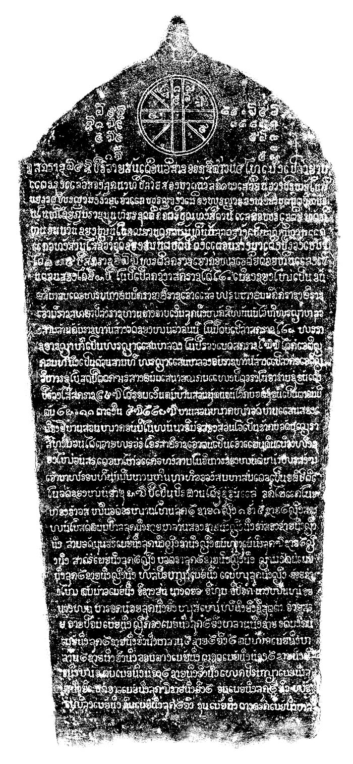
Another important date listed on the stele at Wat Chiang Man in Fig. 13.8 is the starting date of construction, which was in the year 658 CS or Rawaisan (Monkey) year, on the 8th day of the waxing moon of the 8th Lanna lunar month at an early hour. This date corresponds to 4 a.m. on 19 April 1296 (Gregorian date).

The date and time scripted on the stele of Wat Chiang Man. Right: the whole stele. Left: an enlargement of the portion in the red box and in reversed color for clarity (https://db.sac.or.th/inscriptions/uploads/images/20160205143618GRq3.jpg, retrieved February 10, 2020).
Based on the Lanna lunar calendar, the construction starting date and time were calculated using the position of the Sun and the Moon that reached the auspicious ceremony time. The Moon was in the Punarvasu Nakshatra with Pisces ascendant (Meena Rashi Lagna).
The planetary positions specified in the inscription in Fig. 13.8 are as follows: Saturn in Vrishah (Taurus), Mercury in Mesha (Aries), Venus in Meena (Pisces), Mars in Kumbha (Aquarius) and Jupiter in Dhanu (Sagittarius). They coincide with the star map shown in Fig. 13.9. This implies that during that period there was knowledge of how to calculate planetary positions with respect to the zodiac signs. This was probably through Hindu astrology, which used sidereal zodiac signs.

A star map, generated by Stellarium (https://stellarium-web.org/), showing the locations of the Sun, the Moon and planets appearing in the different zodiac constellations as observed from Wat Chiang Man on 19 April 1296 at 4:00 a.m. In the east is the constellation Pisces and Venus were rising above the horizon, shown as the stripped area marked by the letters ‘N’, ‘E’ and ‘S’.
5.3 Interpretation and Discussion
The two selected auspicious dates were related to cosmological phenomena such as the Moon in Punarvasu Nakshatra and the Sun in Mesha Rashi at the time Pisces was ascending (Meena Rashi Lagna). It can be noted that most of the planets, except Jupiter and Mars, were aligned in zodiac signs that were close to the zodiac sign of the Sun (Meena, Mesha and Vrishabha). Moreover, the Thaloeng Sok day, believed to be associated with the vernal equinox, was probably also considered an auspicious date for a new start.
Further discussion on the equinox will be given in Sub-section 13.5.3.1, and astrological aspects on Punarvasu Nakshatra and Meena Rashi Lagna will be presented in Sub-section 13.5.3.2.
5.3.1 Astronomical Aspect
According to Vaastu principles, the site would be plowed on an auspicious day determined by astronomical observation of a pair of specific oxen having white spots on their heads and knees. However, there is no record of the observation of these two stars in either the Chiang Mai Chronicle or the Wat Chiang Man stele.
It can be assumed that Vedic astronomy would have related the rising and setting locations of various stars to the seasons, to the solstices and to the equinoxes. Therefore, it is possible that Aldebaran (or Rohinī in Sanskrit) and the Pleiades (Kritikkā in Sanskrit) might rise in the east at the vernal equinox during Harappan times (3000 to 2000 BCE) as the word ‘rohinī’ literally means ‘rising’. During the Vedic period, the vernal equinox was in Taurus, and it might be considered the beginning of the New Year.
However, the precession of the equinoxes and the difference length between the sidereal and the tropical year were unobserved by ancient people. For naked-eye observers, the shift of the constellations relative to the equinoxes only became apparent over centuries.
For example, Mohenjo-Daro in Pakistan, an important archaeological site during the Vedic and Harrappan periods, exhibited slight divergence of 1–2° clockwise in its axes relative to the cardinal directions. Furthermore, slight differences in the orientations of the various buildings at Mohenjo-Daro indicates that different construction periods were used with the same traditional sighting points that shifted over this interval due to precession of the equinoxes (Kenoyer, 1998).
At another historical site, the fourteenth century Vidyashankar temple at Sringeri, Shylaja (2007) discovered that only two pillars are now aligned with the direction of the rising Sun at winter and summer solstices, whereas the others are no longer orientated to their correct zodiacal signs. The signs shift with respect to the constellations by 1° in about 72 years due to the precession.
Although during a period of CE 1292–1296, Pisces (Meena Rashi) rose in the east on the vernal equinox, Lanna astronomers instead used the Thaloeng Sok day, the day the Sun entered Mesha Rashi, as New Year’s Day.
5.3.2 Astrological Aspects
According to Vedic astrology, the symbol of Pisces is two fish. It is worthwhile considering the significance of this sign when humanity is at the threshold of a new beginning and a new cycle. Pisces is feminine, watery, and common, which is related to the preservation principle. Jupiter is a ruler of Pisces. As an ascendant Lord, it will encourage individuals to grow and prosper in this world. The Hindu, Christian, Pagan and many other regions have shown much reverence for fish. It is one of Lord Vishnu’s incarnations known as Matsyavatar. It was this god who taught mankind to build houses and cultivate land. Ancient Brahmans and the Babylonians also connected fish to their Messiah. Pisces is indeed an auspicious sign with an auspicious beginning (Shah, 2020).
It is interesting to note that King Mangrai chose Punarvasu for the auspicious time of both events. Punarvasu is the birth Nakshatra of Lord Rama, the eternal-incarnation of God (Lord Vishnu) on Earth. He is the central figure of the ancient Hindu Ramayana epic, that has long-established deep cultural bonds between India and Thailand since the sixth century CE. He is considered a supreme being who fulfilled all his moral obligations. King Ram Khamhaeng of Sukhothai and all the kings of the current Chakri Dynasty of Thailand are often referred to as Rama. Even Ayuttaya, a prosperous kingdom that existed for over four centuries, was named after Ayodhya, Lord Rama’s birthplace. Therefore, it is possible that King Mangrai might have been influenced by the ideology of Lord Rama to choose Panarvasu. As the star Punarvasu was in the ascendant, the five planets (Sun, Mars, Jupiter, Venus and Saturn) were in their respective exaltation positions. Punarvasu is known as the Nakshatra of renewal, repetition, and repeating patterns. Pisces ascendant and the Punarvasu Nakshatra were also chosen for auspicious events in Bangkok, and in other cities and temples. It would be interesting to investigate their popularity for auspicious times in the future.
6 Concluding Remarks
We find that the Chiang Mai city planners had seven good reasons (omens) for choosing the location for the new capital city of the Lanna Kingdom when King Mangrai explored the site. The reasons included topographical aspects (e.g., flat land, a mountain, a river and a stream), natural water resources and the fertility of the soil, all of which would help promote harmony between the humans and local plant and animal varieties. The position and direction of the large lake in the northeast was also taken into consideration. Furthermore, King Mangai ordered that city construction would start from the Sri Bhumi corner. Besides the seven good omens, we also investigated ancient Lanna norms, customs and traditions that were passed from generation to generation. Some practices are still applied to this day.
The results of this investigation suggest that the planning of Chiang Mai city was influenced by Vaastu Shastra (an ancient Hindu architectural knowledge base), combined with traditional concepts and beliefs, indigenous Khmer knowledge and technology, Vedic cosmological concepts, and possibly ideas held by the King of Sukhothai.
The city might have been designed using a mandala of be 9 × 9 divided sites (81 squares) in the Paramasayika design. This has a symbolized human figure with the face and the stomach touching the ground lying with his head facing the northeast corner and his legs at the southwest corner. The form was to represent a human living in complete harmony with nature. The city planning thus symbolized a peaceful and a prosperous person.
References
Chandler, D.P., 1993. A History of Cambodia. Chiang Mai, Silkworm Books.
Chakrabarti, V., 2013. Indian Architectural Theory: Contemporary Uses of Vastu Vidya. Abingdon, Routledge.
Chaturawong, C., 2017. Historic town of Sukhothai and cultural aspects of its toddy palm trees. Najua Journal: Architecture, Design and Built Environment, 14, 6–43 (in Thai).
Database of Inscriptions in Thailand | Wat Chiang Man Stale Web site https://db.sac.or.th/inscriptions/inscribe/detail/1424 (retrieved January 30, 2020)
Dutt, B.B., 1925. Town Planning in Ancient India. Calcutta, Thacker, Spink & Co.
Kak, S., 1999. The solar equation in Angkor Wat. Indian Journal of History of Science, 34(2), 117–126.
Kenoyer, J.M., 1998. Ancient Cities of the Indus Valley Civilization. Karachi, Oxford University Press.
Leawrungruang, V., 2014. Lanna architecture alive in Chiang Mai city. In Srisuwan, C., Chantrathit, P., and Suparatpreecha, V. (eds.), Chiang Mai City: Art, Architecture and Beliefs. Chiang Mai, Lanna Architecture Center. Pp. 15–19 (in Thai).
Maison, W., 2019. Decoding of War—Strategic Fate. Bankok, Khonmongfah Publishing (in Thai).
Mannika, E., 1996. Angkor Wat: Time, Space, and Kingship. Honolulu, University of Hawaii Press.
O’Reilly, D.J.W., 2007. Early Civilizations of Southeast Asia. Lanham, AltaMira Press.
Ongsakul, S., 2005. History of Lan Na: Translated by Chitraporn Tanratanakul. Chiang Mai, Silkworm Books.
Patra, R., 2014. Town planning in ancient India: in moral perspective. The International Journal of Humanities & Social Studies, 2, 44–51.
Saelee, C., Tawanatiwas, M., and Yodintra, S., 2018. Suvarnabhumi-Gregorian rule to determine whether Thai lunar calendar year 2012 is a leap-month year. Chiang Mai Journal of Science, 45(6), 2491–2508.
Saran, S., and Shirodkar, A.D., 2017. Vastu shastra and feng shui the ancient sciences and their fusion in context of Indian architecture. International Journal of Scientific and Technology Research, 6(11), 136–144.
Shah, S., 2020. Pisces Ascendant Secrets: Vedic Astrology. Saket Shah.
Shukla, D.N., 1961. Vastu Sastra. Volume 1: Hindu Science of Architecture. Chandigarh, Punjab University.
Shylaja, B.S., 2007. The zodiacal pillars of Sringeri. Current Science, 92(6), 846–849.
Sodabanlu, T., 2006. The design of Chiang Mai city in Lanna culture. Najua Journal: Architecture, Design and Built Environment, 3(4), 138–147 (in Thai).
Tunsuwat, P., 2014. Wat in Chiang Mai as Appeared in Historical Maps. Master of Architecture thesis, Chulalongkorn University, Bangkok, Thailand (in Thai).
Volwahesn, A., 2001. Cosmic Architecture in India: the Astronomical Monuments of Maharaja Jai Singh II. Munich, Prestel Publishing.
Wichienkaeo, A., and Wyatt, D.K., 1995. The Chiang Mai Chronicle. Chiang Mai, Silkworm Books (in Thai).
Acknowledgements
This archaeoastronomical research is an extension to the research conducted earlier by the late Associate Professor Samai Yodinthara, Assistant Professor Mullika Thavornathivas and Associate Professor Sanan Supasai, who gathered information for several years. We are grateful to Professor Boonrucksar Soonthornthum, former Director of the National Astronomical Research Institute of Thailand, who recognized the importance of archaeoastronomical studies of Lanna culture and served as a mentor for this research project. Additionally, the research team would like to thank Dr Pensupa Sukkata (poet, writer, curator and columnist) who provided details about the founding of Chiang Mai; Voranai Pongsachalakor, a scholar in anthropology, history and archaeology, for information regarding Hindu deities; and Dr Direk Injan (Chiang Mai Rajabhat University, Thailand) for guidance and information on reading lunar calendars inscribed on palm-leaves. This work was fully supported by the National Astronomical Research Institute of Thailand.
Author information
Authors and Affiliations
Corresponding author
Editor information
Editors and Affiliations
Rights and permissions
Copyright information
© 2021 Springer Nature Switzerland AG
About this chapter

Cite this chapter
Saelee, C., Riyaprao, O., Komonjinda, S., Sriboonrueang, K. (2021). An Archaeoastronomical Investigation of Vaastu Shastra Principles (Vedic Architecture) Implemented in the City Planning of Ancient Chiang Mai. In: Orchiston, W., Vahia, M.N. (eds) Exploring the History of Southeast Asian Astronomy. Historical & Cultural Astronomy. Springer, Cham. https://doi.org/10.1007/978-3-030-62777-5_13
Download citation
DOI: https://doi.org/10.1007/978-3-030-62777-5_13
Published:
Publisher Name: Springer, Cham
Print ISBN: 978-3-030-62776-8
Online ISBN: 978-3-030-62777-5
eBook Packages: Physics and AstronomyPhysics and Astronomy (R0)