
Abstract
Smart cities, the current movement to advance beneficial programs and applications for urban areas, depend heavily on innovative information technologies, the expansion of data types, and increases in data volumes. This chapter explains that spatially enabled systems are critical to the success of smart cities because their unique integrating, analyzing and visualizing capabilities can multiply the power of conventional IT systems. The chapter identifies the characteristics that distinguish spatial systems and discusses how increasing amounts of interoperable, spatially enabled data is becoming available due to new sensor technologies, the Internet of Things (IoT) and social media. The chapter identifies the standards, architecture and organization structure that can create an effective spatial information environment. It points towards the use of spatial technologies in advanced artificial intelligence applications. There is an examination of the measurable benefits made possible by spatial systems including enhanced revenues, life-saving methods, and increased productivity. The chapter concludes by re-emphasizing the importance of spatial systems for smart cities initiatives.
Access provided by Autonomous University of Puebla. Download chapter PDF
In this chapter, we will explore the movement referred to as Smart Cities from the standpoint of the critical role that spatial systems and capabilities play in this, the latest cycle of the information technology and scientific revolution. According to BSI PAS 180 – Smart Cities Vocabulary 1 , A smart city provides effective integration of physical, digital, and human systems in the built environment to deliver a sustainable 2 , prosperous and inclusive future for its citizens.
Another definition of smart city puts even more emphasis on information and information technology. “A smart city is an urban area that uses different types of electronic data collection sensors to supply information which is used to manage assets and resources efficiently. This includes data collected from citizens, devices, and assets …” 3 . Similarly, according to “Smart Cities, Smart Future” by Mike Barlow and Cornelia Levy-Bencheton, “Smart cities are complex blends of interoperable technologies, systems and services designed and orchestrated to help people lead productive, fulfilling, safe and happy lives” 4 .
1 Introduction
1.1 Prelude to Smart Cities
Smart cities are the latest incarnation of past movements that sought to promote societal improvement and used terms like excellence, reengineering, change, quality, innovation, e-government, and digital revolution. Smart cities draw upon these past concepts but reflect our present time when increases in the volume, types and quality of data, and rapid advances in networking and information technologies represents a qualitative and quantitative advance from the past.
Smartness depends upon the human capacity to observe the world, gather information, and process that information into knowledge, insights, decisions, and actions. Naturally, an essential part of comprehending the world is understanding location: where you are, what is around you, where you want to go, and where things important to you are located. As civilization advanced, location became ever more important, guiding explorers, supporting commerce, and organizing living space. Now, with more than half the world’s population living in urban areas 5 it is important that we fully appreciate that everything contained and occurring within a city has a location: building footprints, property boundaries, utility networks, the movement of people and vehicles at street level, and all that goes on inside buildings. Only by taking the location of everything into account—in as smart a manner as possible—can we hope to grasp the complexity of urban life and meet its challenges.
We know that smartness did not begin in just the past 5 or 10 years. Looking into the past we see successive waves of technology and innovation that have made life better. But since the end of World War Two, one of the primary means for achieving smartness has been through innovations of computer technology based on the development of digital information, integrated circuits, computing devices, telecommunications, and computing software. Computers, with their ability to create, manage, analyze, and transmit huge volumes of information, are now behind most of the scientific advances and operational improvements that we have witnessed in our lifetimes.
Computer technology revolutionized the way information was recorded, stored, and analyzed. However, the location field of a data record was often the most problematic. There were many different ways of assigning and recording addresses with inconsistency and mistakes more common than not. Address data is known to have an error rate that can exceed ten percent. And addresses could not adequately deal with vacant land, open spaces, water bodies, the underground, or space above buildings. Conventional databases also had no way of either recording or analyzing the geographic relationship of physical objects in space, such as a building’s placement on its parcel and the access points of utilities that supplied it with water, electricity, and other services. While the large majority of data records had a location field, bringing information together on the basis of location was unreliable, when it was not impossible.
It took geographers and data scientists many years before the indicators of location could be digitally defined and automated to form the basis for spatial information systems. The moment of birth for geographic information systems (GIS) is tied back to the work of Dr. Roger Tomlinson, who developed the first known computerized spatial database for the Canada Land Inventory in the early 1960s. A revolutionary advance occurred when a network of global position satellites was put into orbit, in the 1970s, which enabled Earth coordinates to be rapidly and accurately captured for any point on Earth 6 . During this time of spatial evolution, practitioners understood that spatial systems were evolving as an extension of information technology; but that adding the location element created a new dimension of smartness, often referred to as location intelligence. Early applications of GIS were standalone systems, residing in agency silos, that served limited functions within environmental, planning, health, transportation, and public safety agencies. Often, individual agencies developed a basemap customized for their unique needs. Data represented on one map often could not be used with the data from another. Spatial systems were created, but they were not interoperable.
1.2 Enterprise GIS
From the mid-1980s through the 1990s, many large municipalities and urban counties advanced from standalone spatial systems to Enterprise GIS (Fig. 31.1). To achieve this many jurisdictions, such as New York City, created photogrammetric basemaps, deriving streets, buildings, and other identifiable objects and boundaries from aerial photography. These foundation or framework layers created locational anchors for other datasets, allowing them to be stacked one on top of the other for visualization and analysis. This made it possible for the now standardized location fields of databases to be used as the common element to conduct searches and analyses. Enterprise spatial systems could grow to encompass hundreds of datasets from dozens of participating municipal agencies. Enterprise spatial systems enabled increasing levels of data integration, analysis, and … smartness. Decision support became more robust, and city operations from emergency response to responding to pothole complaints, and hundreds of other applications as well, benefited from more accurate, comprehensive and timely information organized by location.


Geospatially enabled enterprise data integration (GEDI). Aligned geographic signifiers allow data integration and interoperability
During the late 1990s enterprise GIS allowed government and private firms using spatial capabilities to get smarter. At the same time, it became increasingly clear that information technology in general was having a revolutionary effect on how cities functioned. In the early 2000s, the idea of Smart Cities started to take hold as a term to characterize the growing benefits being achieved by IT systems in general.
If asked to pick a date when the concept of spatially enabled smart cities originated, we would choose September 11, 2001, the day of the attack on the World Trade Center in NYC. The formation of the Emergency Mapping and Data Center (EMDC) by NYC’s Office of Emergency Management demonstrated the importance of spatially enabled enterprise data integration to support the response to a massive disaster event. Thousands of maps and spatial analytic products were provided to responders from dozens of organizations, and those organizations contributed their data so it could be pooled together for analytic purposes. Sensing technologies on a large scale were utilized. GPS-enabled data collection tools were deployed to the field. Interactive maps were posted to public websites to inform the public about critical aspects of the response effort. Underground infrastructure data from all utility organizations was assembled, integrated and analyzed (Fig. 31.2) (for more details, see Case Study of 9/11 in Sect. 31.5.5). Although getting all that data to work together was a time-consuming, technical challenge that was realized imperfectly, those involved fully recognized that the power and benefits of spatially enabled data interoperability would be fundamental to any future idea of smartness.


Spatial support provided by the NYC Emergency Mapping and Data Center (EMDC) in response to 9/11. (Courtesy of NYC Department of Emergency Management)
Over the past 20 years we have witnessed a rapid transformation of our technological environment. In addition to the increases in digital storage and computing capacities, many new types of computer devices and sensor technologies have gained widespread use. Almost everyone now carries a smart phone equipped with a GPS receiver, and GPS-enabled wearables are increasing in popularity. At the same time sensors, collecting and transmitting many kinds of spatially enabled data, have increased in functionality and capacity. All these new data sources—from people and things—are tied together by the internet and by a common spatial framework, creating the potential for bringing increasing volumes and types of data together, at enormous speeds, for uses never before contemplated.
1.3 Spatial Data Infrastructures
As cities, counties, and states were starting down the path to enterprise GIS, the US Federal government and international standards setting bodies were working to create national spatial frameworks in which local spatial infrastructures could fit. In April 1994, US Executive Order 12906 codified the coordination of Federal, State, local, and tribal governments, and the private sector, to be on a standardized National Spatial Data Infrastructure (NSDI) to support public and private sector applications of geospatial data in such areas as transportation, community development, agriculture, emergency response, environmental management, and information technology.
The goal as described in the Global Spatial Data Infrastructure (GSDI) Cookbook 7 was to be able to access, integrate, and use spatial data from disparate sources in guiding decision-making. The ability to make sound decisions collectively at the local, regional, and global levels is improved by implementation of SDI for compatibility and interoperability across jurisdictions. Through common conventions and technical agreements decision-makers can more readily discover, acquire, exploit, and share geographic information vital to the decision process. The use of common conventions and technical agreements makes economic sense because they limit the cost involved in the integration of information from various sources and eliminate the need for parallel and costly development of tools for discovering, exchanging, and exploiting spatial data.
Development of NSDI by the Federal Geographic Data Committee (FGDC) involved promoting development and eventual endorsement of open standards from the International Organization for Standardization (ISO) Technical Committee 211 (Geographic information/Geomatics) and the Open Geospatial Consortium (OGC). SDI development was a primary reason for the formation of the OGC in 1994. ISO and OGC standards are essential elements in SDIs around the world. This is because SDIs are data and service networks, and networks depend on open standards. Making policies that maximize the use of geospatial products, solutions, and services that implement these standards, is the best way to maximize returns on investment.
While SDI implementation was more pervasive at state and federal levels 8 , the role of data sharing interoperability based on standards remains an imperative for local governments. In the early 2000s, a hybrid or “middle-out” approach began to emerge that took combined elements of NSDI with the dynamics of local government 9 . By recognizing the value of SDIs based on open standards to local governments, NYC again led the way. To address the challenges encountered in the 9/11 response, NYC GIS and OGC initiated a discussion of the coordinated development of open standards to meet urban interoperability needs. Several OGC Testbeds were based on needs and scenarios from NYC to drive interoperability solutions. OGC Testbeds are the core of the OGC Innovation Program, resulting in rapid definition and implementation of open consensus standards in OGC’s Standards Program (Fig. 31.3).


Spatial Data Infrastructure brings distributed data to consumers. (© OGC 10 )
1.4 Key Characteristics of Information-Enabled Future Smart Cities/Societies
The spatial components for Smart Cities build on Enterprise GIS and SDI, but more must be done. Essential will be the continued work of several international standards development organizations: ISO, IEC, ITU, OGC, and others, which broadly address the data and technology context of Smart Cities. The future information environment will be one where everyone and everything is capable of providing and receiving multiple kinds of information, most of it containing a location identifier. The richness of this data makes it possible to imagine ever increasing levels of smartness based on the following characteristics:
-
Data accuracy, completeness and timeliness: the evolving data and technological environment makes it possible to improve the data available to us for smart purposes. Smart data is data that is accurate and detailed and made available to users when and where they need it.
-
Data interoperability: the data from traditional IT systems tends to be isolated in silos. It remains a challenge to bring different kinds of datasets together even as it is recognized that data interoperability enables new insights and knowledge. Smart Cities demand that data in any combination needed to solve a problem or support an operation be quickly and easily brought together for analysis and sharing.
-
Improved analytics: with so many new, high-volume sources of data becoming available, Smart Cities must develop improved analytic techniques and methods to turn combinations of interoperable data into increasingly useful intelligence products. Also, given the large amounts of unstructured data made available via social media, personal devices, and the Internet of Things, new methods need to be found to process this data in ways that allow the extraction of useful information using big data analytics.
-
Suitability for artificial intelligence (AI): high volumes of data, such as those generated in response to a large-scale disaster event, can be overwhelming. AI is a branch of computer science characterized by the use of techniques that automatically identify, combine, extract, analyze, and process information, creating intelligent products for a variety of users, from workers in the field to executive suite decision-makers. AI systems—through a process called machine learning—are being designed to use the feedback from errors and mistakes to improve future performance. For example: computer models that predict the path and intensity of hurricanes can incorporate lessons learned from past inaccuracies so that future forecasts are more precise.
-
New, real-time sources: web technologies encourage the easy publication and immediate access to data coming from many sources. Social media allows individuals to post information that immediately affects events. Twitter is regularly used by protestors and demonstrators in order to communicate and affect events. All kinds of sensors communicate the situation in urban environments to anyone on the web. The Internet of Things already has more connected devices online that there are people in the world.
-
Automation support: improved sensor, processing, and communications technologies can capture, transmit, and analyze high volumes of spatially enabled data at split second speeds, enabling robots and other kinds of mechanical equipment, which move in three-dimensional space, to become smarter. For example, we are now witnessing the evolution of smart vehicles that are increasingly performing driver-assist functions and may, in the future, take over the entire job of driving. This will require continuous, real-time awareness of vehicle position and the location of nearby people and objects, in order to move safely from one place to another.
The above are key characteristics of data and technology that will support Smart Cities programs in the future. In the next sections, we will show how these capabilities are empowered by spatially enabled applications and systems, utilizing data whose spatial characteristics can serve as the glue linking different kinds of data together. These spatially empowered systems have the ability to multiply the power of conventional IT applications.
2 Unique Capabilities of Spatially Enabled Systems
Maps are the most recognizable and readily accessible spatial information. Yet, a focus on maps often obscures the fact that the power of location goes well beyond visualization. To this day, it remains common to hear talk about big data analytics without mention of spatial systems that have been integrating and analyzing combinations of large, location enabled datasets for decades. When most people look at a 3-D semantic model of an urban landscape, they do not understand that every pixel (or voxel) and every object represented is both highly accurate and intelligent: the carrier of attribute data that can be analyzed in an almost infinite variety of ways.
So what is it exactly that makes spatially enabled systems so powerful and useful? What follows is a partial listing of spatial capabilities that extend the power of conventional IT systems. Members of the New York State GIS Association at their September, 2018 Summit, when surveyed informally, stated unanimously that the addition of spatial capabilities at least doubles the power of nonspatial information systems. The implications for Smart Cities are enormous: These spatial powers enhance all the key aspects of data usage identified in Sect. 31.1.4, which characterize the use of information technology for Smart Cities programs.
2.1 Precise Location – Instruments for Large-Scale Data Gathering
Determining the exact location of points on the ground was once the sole domain of surveyors and navigators employing manual and semimechanical methods to provide geospatial coordinates such as latitude and longitude. In 1967, the US government began launching the Timation satellites that transmitted signals allowing anyone with the proper equipment to calculate their location. This was the precursor to the now ubiquitous GPS network 6 . Location points, assembled as a map-matrix of pixels could then be differentiated to provide spatial identity to lines, polygons, and areas such as streets, buildings, and natural features. With the addition of vertical data, now obtained from lidar sensors, pixels can be turned into voxels, the basic building blocks for representing objects in three dimensions. Other than being the passive carrier of spatial coordinates, conventional IT systems have no ability to use location information for mapping and analytic purposes. Generic databases must be augmented with spatial commands that can measure distance between two points, tell whether two objects touch, and know which way water flows in a network or pipes, and traffic moves on a street grid. It took the development of geospatial information systems to make this possible.
2.2 Geocoding Application to Integrate Location Identifiers
Before the advent of GPS, many types of objects and areas, common to cities, were given individual identities that placed them at a particular location and provided the basis for maps created on paper or other recording media. For example, buildings had street addresses and unique building identification numbers. Every property parcel had a block number and lot number. Census tracts were defined by street centerline segments. With the ability to give standardized spatial coordinates to these objects, it became possible to relate them to each other with a high degree of spatial accuracy. Thus, data tied to buildings could be related to data tied to parcels and to surrounding streets. Within a city, or any other kind of jurisdiction, this meant that all data related to a spatial object could be integrated and made interoperable.
2.3 Building Multijurisdictional and National Data Layers
Conceptually, building framework data layers, considered to be essential for enterprise GIS, that are seamless across jurisdictional borders and can be assembled into national coverages, is simple. See Fig. 31.4 which shows the interconnection of Lego blocks. This illustrates that once key components of data layers are spatially standardized, they can be layered and connected in any way desired across areas as large as needed. In this way, information from federal, state, local, private sources can be put together as long as each level of government conforms to common standards. GIS framework layers, suitable for standardization include imagery, elevation, hydrography, parcels, streets and addresses, and buildings. Two or more jurisdictions can then link their data across boundaries making sure all features are properly aligned and connected. Of course, achieving this level of this integration is not easy – especially because governments lack the awareness and determination for national standard setting. However, we see hopeful signs.
-
The National States Geographic Information Council (NSGIC: www.nsgic.org) made up of the Chief Geospatial Information Officers of all U.S. states has made progress with their “For the Nation” proposals, and is working with the Federal Geospatial Data Committee (FGDC: www.fgdc.gov) composed of Federal agency GIO's, to fund the development of key national framework layers.
-
A number of states contract for the collection of state-wide imagery, providing it at low cost to their counties and municipalities, which are given the opportunity to upgrade the resolution of the product to suit their needs, within the framework of common accuracy standards. New York State in particular has created statewide layers for imagery, streets, parcels, and addresses.
-
Similar to states, a number of counties, such as Westchester, Rockland, and Suffolk Counties in NYS, collect county wide data and make it available to their municipalities.
-
Since Westchester and New York City independently created their enterprise GIS data to a common standard, it only requires the determination to properly fit features along their border for their GIS data to be fully aligned.
-
The Federal Homeland Infrastructure Foundation Layer Data program of the U.S. Department of Homeland Security has assembled more than 600 national infrastructure datasets (HIFLD Open Data (arcgis.com)) many of which are now available for public download and use.
We hope these steps forward both in the U.S. and other nations continue. The full benefits of GIS for innumerable applications that save lives, improve services, protect the environment, can only be achieved when data across jurisdictions and nations can be made interoperable.


Vision for integrated federal, state, and local data. When data is created by different levels of government on common foundation layers to common standards, it can be combined across geographic areas
2.4 Giving Location Identity to Sensors
Sensors are devices that capture and transmit observations about their surroundings—the characteristics of natural and human phenomena—and are used to detect and measure microorganisms, chemicals, temperature, vibration, speed, and even human presence and behavior. Sensor observations can be used to trigger automated mechanical devices and to send alerts should dangerous conditions be detected. A vital attribute of information collected from a sensor is its location, because measurements are meaningless without knowing where they came from and without being able to synthesize readings from across a larger area to calculate variation and detect patterns. Hence, practically all sensors have the ability to impart location identity to the information they collect and transmit. Additionally, the data from different kinds of sensors covering the same area can be made interoperable if location data standards are adopted. The fusion and analysis of data from multiple types of sensors can give a richer understanding of an area under observation or study.
2.5 Spatial Queries and Linked Data
SQL, or structured query language, is the way software programmers ask questions of databases and perform analyses. Spatial SQL expands the range of conventional SQL by enabling queries to address spatial points, lines, and objects and the attribute data associated with them. Spatial SQL, unlike standard SQL, can determine the distances between points and objects, and whether objects are touching, overlapping or in any other kind of spatial relationship with each other. Spatial SQL substantially increases analytic options and enables the achievement of new levels of intelligence to support government and business operations and decision-making. The use categories and use cases described in Sect. 31.5 of this chapter all take advantage of the power of Spatial SQL. One notable application is the use of CompStat by police departments across the country to map crime incidents, identify and analyze crime patterns by incident type, location and time of day; and use this information to design effective strategies (Sect. 31.5.5).
Linked Data 11 is defined as a method of publishing structured data so that it can be interlinked and become more useful through semantic queries 12 across the web. Work is now being done to extend Linked Data to include spatial and temporal characteristics so that, for example, Linked Data in Resource Description Framework (RDF) 13 or Web Ontology Language (OWL) 14 can be queried by using GeoSPARQL 15 , a web query language. In this way, structured and semistructured location enabled data can be mixed, exposed, and shared across different applications. Part of the vision of spatially enabled Linked Data is for the internet to become a global database that can serve as a platform to extend spatial analytic capabilities.
2.6 Network, Routing, and Analysis
The built environment is composed of physical elements such as pipes, conduits, tunnels, and valves that are networked together to form underground utility systems and building infrastructure. The various products flowing through these systems include water, sewerage, electric power, gas, and data. Spatial systems have the intelligence to know which network components are connected to each other, where they are located, and in which direction network products are traveling. Spatial systems also give locational identity to the sensing and controlling devices that allow such networks to be monitored and actively managed. These capabilities make possible a wide range of asset management applications that can give operators and owners important tools with which to operate and maintain their networks.
Networking and navigation: the networking capabilities of spatial systems can also be applied to transportation routes that can be mapped in detail, whether for travel underground, on roadways, across waterways, and through the air. The economy of our planet depends on the supply chains sending and receiving raw materials and finished products, and spatial systems have the ability to optimize and monitor supply chains and transportation routes. GPS-enabled sensors can track the location and characteristics of all vehicles in real time. The fact that every street and roadway in the US is mapped, with details about traffic direction and capacity, as part of a connected network, enables vehicle fleets to be efficiently routed and has made it possible for emergency response units, and new taxi services, to go from where they are to where they need to go in the most efficient way possible.
2.7 Spatial Visualization: Maps and 3-D
Conventional IT systems visually represent data in the form of graphs and charts. Spatial databases additionally allow data to be represented in the form of maps. Spatial systems have the ability to provide operators with the choice of displaying any combination of hundreds of spatial layer options, with the assurance that the different data layers will accurately represent relationships between different kinds of objects. While spatial analytics is invaluable, we should not discount the importance of the ability of the human mind to identify patterns from data represented on a map. Map visualizations and spatial analytics work synergistically: operators notice patterns by visual inspection and then turn to spatial analytics to confirm or expand upon their intuitive understandings. Additionally, a map is a very effective graphical user interface (GUI) that gives technical and nontechnical personnel alike the ability to maneuver through large amounts of data to discover and interact with information. Many government and business online applications utilize maps as a primary means of guiding citizens and customers through a wide variety of transactions.
The world is not a flat map, and map projections that create various kinds of flat two-dimensional maps will always be limited, even though they will be with us for some time to come because they are embedded in our legal definitions of boundaries and locations. We already see how to go beyond flat map projections based on digital data models and computer visualization. Google Earth was successful because computers became capable of 3-D visualization. The next generation of 3-D visualization capabilities, based on open standards, is being implemented with indexed 3-D scene layers (i3S) 16 , now released as OGC Community Standards. Data analytics on the globe have become easier with the advent of Discrete Global Grid Systems (DGGSs) 17 . DGGSs do not have the troublesome attributes of date lines and poles that come with map projections. Analytics in DGGS provide capabilities that are revolutionary.
The evolving capabilities described above are unique to spatial systems and provide a significant boost to Smart Cities applications. As increasing amounts and types of spatially enabled data become available, and as new spatial technologies increase capacities and capabilities, IT systems will benefit from extra measures of spatial power to pull all this data together and make sense of it.
3 Spatial Data Options for Smart Cities
3.1 The Spatially Enabled Data Explosion
Around the year 2000, we entered another phase in both the IT and the spatial revolutions. Since then, we have experienced a quickening of the growth of data volumes spurred by new types of location enabled data, new applications, and technologies that can make everyone a data user and everything a data generator (Fig. 31.5). The availability of these growing data resources is creating enormous opportunities for ever more effective smart applications. These developments are greatly aided by the fact that most of this data is being tagged with location information enhancing the potential for interoperability, and for more robust, spatially driven analytics. Below are some of the contributors to this new, richer spatial environment.
-
Smart phones and wearables: smart phones, smart watches, and other devices carried by individuals have changed the information technology environment as much as desktop computing did in the 1980s. Smart phone ownership now extends to more than two billion people worldwide, and it is easy to foresee a time when almost everyone will have one. Smart phones and other personal devices have embedded GPS capabilities and serve as the platform for many types of detection and image capture applications. Personal and business transactions are increasingly being performed on smart phones, and many types of applications are being redesigned to accept input from these mobile platforms, including the Next Generation 911 emergency response system. The emergency response community is actively looking for ways to tap the power of smartphones to support disaster preparedness and response operations, where interchange between responders and the public is critical. In a similar way, new generations of wearable devices can be used to closely monitor personal health status and may one day communicate directly with autonomous vehicles to improve pedestrian safety.
We are moving towards a future where the citizen will become a major contributor of accurate, real-time information that will improve the quality of life of everyone.
-
Social media: a variety of new application platforms, including Facebook, LinkedIn, Instagram, Twitter, and many others, enable individuals to join together for a variety of personal, recreational, community, political, and job-related interactions and activities. The billions of people who participate in these networks inevitably reveal enormous amounts of information about themselves: their personal characteristics, thoughts, and activities, often tied to their location. Data scientists have learned that valuable intelligence, for both good and bad purposes, can be derived from this data. On the positive side, social media-related big data analytics can help governments to better identify and respond to social problems.
-
Remote sensing technologies: new generations of cheaper and more powerful large-scale data collection sensors, mounted on satellites, aircraft, and terrestrial vehicles, are making it possible to detect characteristics of our natural and built environment to a degree never before possible. Light detection and ranging (lidar), ground penetrating radars (GPR), synthetic aperture radars (SAR), hyperspectral, thermal, and magnetic field sensors are able to penetrate the ground and see through walls to identify important features and characteristics. New advances and applications for lidar should be especially noted. They have become invaluable to mapping the elevation of land and the exterior of structures. They are now also being used to collect information about building and tunnel interiors. In coming years, sensor technology should advance to the point where it sees beneath the street pavement to detect the location and depth of underground infrastructure.
-
Fixed sensors and the Internet of Things: sensors are now being attached to, or incorporated into, everything from household appliances to streetlight and signal poles, and utility valves, pipes and house connections. High-capacity sensors attached to cars and trucks will provide the foundation for autonomous vehicles. Sensors capture information about the operations of the things they are connected to and also give them a precise location. Sensors attached to street furniture can monitor air quality in real time. Vehicles’ sensors can alert authorities to traffic jams and accidents as they occur. Sensors and smart valves embedded within underground infrastructure networks can monitor utility performance, provide alerts about hazardous underground conditions, and customize utility services to fit the needs of each household.
-
Video capture: Fixed and mobile video sources are increasingly being used to improve security. In cities like London and New York, video devices attached to street furniture, transit stations, and buildings work as part of an interconnected security system. Video device location and the spatial identity given to each pixel in a video image are essential for efficiently searching and relating multiple video streams, each generating enormous volumes of data. Pattern recognition techniques are now starting to be employed to rapidly search video images to identify dangerous behavior that might require a quick response.


Expected growth rate of data. After 18 . Courtesy of Hewlett Packard Enterprise. A ZB is a zetabyte which is a large measure of digital data volume
3.2 Major Spatial Technology Platforms
Smart Cities rely upon ever more effective applications of information. We are living in an age where, as described above, vast amounts of new, spatially enabled information are becoming available. This data tsunami flows from four major overlapping technology platforms all of which now have the ability to create and share spatially enabled data:
-
Integrated, spatially enabled enterprise platforms that create a spatial information foundation within an urban area enabling government, businesses, and other organizations to manage their operations more successfully. This platform also includes operating and transactional data created by spatial enterprise users of all kinds.
-
Personal technology platforms such as home computers, smart phones, and wearables that can be used to both actively and passively create and share data through a wide variety of transactions. Social media data is created on this platform and is connected together by the internet.
-
Remote sensing platforms that collect location data about the physical and environmental characteristics of the Earth, often in broad sweeps from satellite or fixed wing aircraft, and local sensor data that monitors a narrow range of inputs from a fixed or mobile vantage point.
-
The Internet of Things (IoT) that provides information about, and the location of, everything from underground utility valves to household appliances, giving private citizens and business managers greater information about and control over their assets.
Each of these platforms increasingly generates data of greater detail, accuracy, completeness, and interoperability, for business applications, decision support, and analytics. Datasets, regardless of the platform of origin, can be organized and brought together by using their common spatial links, in any combination found valuable. Whether from a single “big” dataset generated from social media or a combination of many discrete datasets from local government, this expanding universe of spatial data can be acted upon by the special spatial capabilities described in Sect. 31.2 of this chapter to create new levels of smartness. In short, as the volume of spatially enabled data grows, the value of spatial systems will continue to expand.
We have only begun to figure out how to best utilize our burgeoning spatial data capabilities. The data science programs of many colleges and universities, private research centers, government developers, and entrepreneurs are all hard at work looking for data combinations, analytic techniques, and technologies that produce effective results. Section 31.4 will focus on the key support elements that must be present in order to facilitate the full exploitation of spatial capabilities.
4 Spatial Standards, Data Models, Architecture, and Organization
4.1 The Role of Software Engineering in Smart Cities
To this point in the chapter we have underscored the importance to Smart Cities of establishing an enterprise GIS to give standardized spatial identity to everyone and everything to be found within an urban area. We have gone on to identify special spatial capabilities that extend the analytic powers of spatial systems beyond conventional IT applications. We have also described the characteristics of a greatly expanding data environment where spatially enabled data interoperability supports more effective applications and more powerful analytics.
The job of making sure that there is an effective spatial data infrastructure to serve as the platform for these new capabilities and applications is a challenging one. It requires that spatial data standards be designed and implemented across information generating platforms, so that spatial data fields can be confidently used to link datasets together. Also important are standardized data models that enable even tighter integration of the datasets within specific use categories such as underground infrastructure (UGI) and Building Information Modeling (BIM) systems. Furthermore, to enable awareness, access, transport, and analysis of spatially enabled data, a technical architecture must be put in place to handle the high-volume flows of information needed to support demanding uses, including big data analytics and artificial intelligence applications requiring massive flows of real-time data. Finally, knowledgeable managers and technical experts must be in place, properly organized and fully empowered, to ensure that the full value of spatially enabled systems can be realized.
4.2 Data Standards
The reason computer and telecommunications technology exist at all is due to the value of data, especially when that data can be transformed into operational intelligence. Raw data, with all its inevitable flaws and shortcomings, is not good enough, especially if it needs to be used for life-saving missions and the support of vital services for millions of people. In Sect. 31.2, we spoke about the unique capabilities of spatial data; however, these capabilities cannot be utilized if data is incompatible and of poor quality. It is the job of spatial standards to define the characteristics of data that will make it accurate, complete, and interoperable. Figure 31.6 illustrates how increasing levels of data integration and processing capacity enable applications of increasing complexity and value. Without standards there would be no assurance that data was trustworthy of being used effectively together.


A continuum of data to knowledge. After 19
A discussion of spatial data standards must begin with the work of the Open Geospatial Consortium (OGC).
To quote from their website,
“The OGC is an international consortium of more than 500 businesses, government agencies, research organizations, and universities driven to make geospatial (location) information and services FAIR – Findable, Accessible, Interoperable, and Reusable.
OGC's member-driven consensus process creates royalty free, publicly available, open geospatial standards 20 . Existing at the cutting edge, OGC actively analyzes and anticipates emerging tech trends, and runs an agile, collaborative Research and Development (R&D) lab – the OGC Innovation Program – that builds and tests innovative prototype solutions to members' use cases” 21 .
OGC was founded in 1994 and has already passed its 25-th anniversary. The OGC Technical Committee is responsible for standards development and works through a series of subcommittees, domain working groups, and standards working groups. Among OGC achievements is the consensus adoption of KML (formerly Keyhole Markup Language), a widely accepted method for visualizing geographic data on a virtual globe:
“Geographic data adds tremendous value to the online experience. More and more people are looking for ways to incorporate location information into their online content,” said Michael Weiss-Malik, KML product manager for Google. “The standardization of KML makes it possible for both novice and expert users alike to publish and share geographical information in an open format. It’s not unlike web browsers’ standardized support for HTML, which allows any web browser to read any web page” 22 .
The OGC Web Services (OWS) suite of standards 23 provided the needed consensus to achieve the first generation of spatial data infrastructures. Through endorsement of OWS standards by GSDI, several national SDIs, and the trans-European SDI known as INSPIRE, thousands of web services are now offering hundreds of thousands of spatial data layers for access by anyone with a web browser. The OWS suite consisting of the Web Map Service (WMS), Web Map Tile Service (WMTS), Web Feature Service (WFS), Web Coverage Service (WCS), and Web Processing Service (WPS) continues to evolve to the latest web technologies. A draft version 3 of WFS—refactored to a resource-oriented design and utilizing the latest API technologies—has been released in 2019 for testing and public comment, and can be found at OGC Web Feature Service 3.0: Part 1 – Core (opengeospatial.org).
Building on the operational OGC Sensor Web Enablement standards, OGC’s SensorThings standard enables fixed and mobile sensors of all types to “talk” to each other.
“The OGC SensorThings API provides an open, geospatial-enabled and unified way to interconnect the Internet of Things (IoT) devices, data, and applications over the Web. At a high level the OGC SensorThings API provides two main functionalities and each function is handled by a part. The two parts are the Sensing part and the Tasking part. The Sensing part provides a standard way to manage and retrieve observations and metadata from heterogeneous IoT sensor systems. The Tasking part is planned as a future work activity and will be defined in a separate document as the Part II of the SensorThings API” 24 .
4.3 Standardized Data Models for Key Smart City Use Cases
OGC looks to identify important business use cases where data silos and a lack of standards inhibits data interoperability and undermines efficiency and effectiveness. This includes initiatives related to the 3-D urban landscape (CityGML), Building Information Modeling (BIM), underground infrastructure (UGI), and emergency preparedness and response. OGC utilizes a standard methodology to approach these thematic areas.
4.3.1 CityGML
CityGML is an OGC-developed open data model and XML-based format for the storage and exchange of virtual 3-D city models. It is an application schema for the Geography Markup Language version 3.1.1 (GML3), the extendible international standard for spatial data exchange issued by the Open Geospatial Consortium (OGC) and ISO/TC 211. The aim of the development of CityGML is to reach a common definition of the basic entities, attributes, and relations of a 3-D city model. This is especially important with respect to the cost-effective sustainable maintenance of 3-D city models, allowing the reuse of the same data in different application fields 25 .
4.3.2 Building Information Modeling (BIM)
The most efficient and effective way to manage and maintain a building is to have integrated information about all aspects of a building’s physical foundational, structural, and mechanical components, including its connection to the ground and to the utilities that provide it with water, power, and other services. This requires that data about building design, construction, and maintenance be integrated into systems that manage and optimize all aspects of building operations. Sensors, videos, and interoperable digital drawings and maps must be combined through all phases of design, construction, and maintenance processes. Since a building is a vertical map made up of interconnected utility and structural networks and systems, BIM is heavily supported by spatial data and spatial analytics 26 .
4.3.3 Underground Infrastructure (UGI)
The subterranean area beneath city streets and buildings has always been terra incognita. Until only recently information about water, sewer, gas, electric, telecommunications, steam, and transit networks was locked away in utility data silos, difficult to access even by the data owners. However, there is now increasing recognition that rapid access to accurate, standards-based utility information can support a wide variety of use cases, including excavations, asset management and emergency and disaster response (Sect. 31.5.6). Utility data becomes much more valuable when the data from any one utility is interoperable with the data from other utilities, creating new analytic options and enabling collaborative work between utilities. In a disaster event, rapid access to interoperable infrastructure information is indispensable and can be a life saver 27 .
4.4 Key Architectural Elements
Figure 31.7 presents a framework that depicts all the key elements of a spatial data and applications architecture. This architecture will only work effectively if the spatial data it supports conforms to standards and is, therefore, interoperable. Several key components of this architecture are noted below:
-
The IT foundation: many business and government organizations have established their computer operations on a conventional IT foundation. Because the development of spatial information systems lagged behind the development of IT, most computer infrastructures were not designed to support the larger volumes of spatial data, nor the need to bring spatial data together from many different sources. As the size of spatially enabled datasets continues to grow, current IT infrastructures will need to be redesigned, and technicians and managers with a solid spatial understanding will need to be hired.
Fig. 31.7 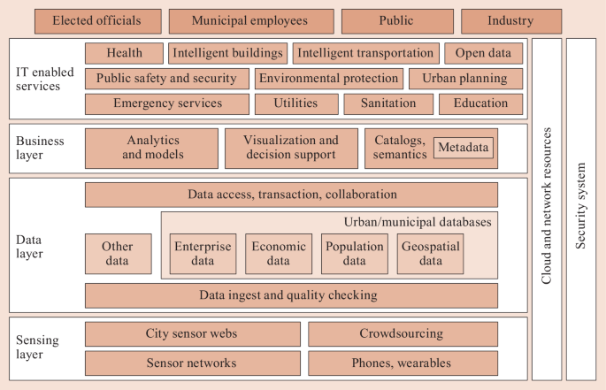
Smart City ICT Framework, Enterprise Components. After 28
-
The cloud: the creation of massive computing environments with enormous storage, processing, and telecommunications capacities is perfectly suited for the spatial data operations of the future. Instead of individual organizations creating high-capacity, customized environments of their own, they can use cloud resources, almost always at much lower cost. At times of extremely high usage, such as during an emergency or disaster event, local servers are almost always overwhelmed, while a cloud environment has the potential to provide almost unlimited amounts of additional capacity for as long as it is needed.
-
Security: standards-based, spatially enabled data shared across organizations has the potential to solve problems and create new kinds of valuable intelligence. This requires that participating organizations believe their data assets will be safe from theft, tampering, and other destructive activities. Effective security is, therefore, an essential component of a successful spatial data architecture.
-
Data discoverability, accessibility, and usability: the increasing power of spatial systems cannot be reserved for use by technicians alone. While there will always be areas that only highly trained experts can master, it is important that spatial infrastructure be designed to enable access and use by anyone. This will require the building of easy-to-use spatial data search tools that can discover datasets of interest, simplify their download and integration, and enable analytics through dashboards and map-based graphic user interfaces.


4.5 The Spatial Organizational Infrastructure and Policy
An enterprise computer environment that is heavily based on spatial data and analytics requires a personnel structure that differs from the traditional IT organization chart. Adherence to old hierarchies and obsolete cultures will not produce the kinds of benefits that spatial capabilities have the potential to provide. Spatially trained personnel are among our most valuable resources. They must be provided with an organizational framework that empowers their skills and brings out their creativity. The following are a few examples of the kinds of organizational practices that need to be adopted:
-
Chief Geospatial Information Officer (CGIO): many traditional IT shops either fail to have a spatial division or bury their spatial expertise beneath layers of bureaucracy, cutting them off from decision-making, essential staffing, and necessary funding. This is tantamount to reducing the potential effectiveness of IT operations by half, if not more. It is essential that IT organizations recognize the importance of spatial capabilities by ensuring that the CIO has a CGIO directly reporting to her and is provided with staff and funding to do her job properly. An organization’s GIO must be more than a good technician. She must be able to convince decision makers about the value of spatial capabilities, and must effectively manage budgeting, procurement and maintenance processes. The CGIO must be directly involved in all major IT decision-making, because the effectiveness of spatial systems is contingent on the suitable design of the underlying computing infrastructure and on the overall IT strategy.
-
Spatial steering committee: a sizable city could well contain 20 or more agencies, each with their own GIS division, each division managing a number of spatial databases and applications. At the same time, each agency will depend upon the creation and maintenance of foundation spatial datasets like imagery, streets, buildings, parcels, and addresses. To achieve the most effective management and operation of a city’s spatial infrastructure, a steering committee of agency spatial managers needs to be formed. Such a committee will support data sharing, collaboration on common applications, investment in spatial data and technology infrastructures, and the evolution of an effective architecture to support agency and citywide missions.
-
Spatial strategic planning: given the importance and power of spatial systems and recognizing that spatial capabilities must be coordinated across all sectors of a jurisdiction and of a region or state, it is essential that CGIO’s be given the authority and resources to develop a spatial strategic plan that is integrated with the IT strategic plan but that extends beyond the boundaries of a specific agency to embrace the jurisdiction as a whole. The spatial strategic plan must also be integrated with smart city policies and programs, because almost every smart city initiative will have a spatial component.
-
Innovation through prototyping: modern IT development relies on rapid experimentation to identify novel methods to extend existing capabilities. A geospatial innovation culture regularly conducts hackathons and other initiatives that focus on software developer interactions. Low-cost, open-participation iterative experiments, testbeds, and pilot projects based on free and open interface and encoding standards encourage innovation and provide insight and guidance that can optimize for improvisation and resilience, as well as prevent expensive IT failures.
-
Architecture and policy: a key objective for the management of smart city information technology and its benefits is to convert short-term successes into enduring value in municipal government. Vendors are at the forefront of developing new spatial capabilities for cities, states, and counties. However, many of these innovations are dependent upon a single provider due to a lack of common interfaces. Software engineering practices oriented towards open interfaces and encodings that support interoperability are critical. The more advanced smart city programs are designing robust software architectures that incorporate open standards, thereby guaranteeing greater data interoperability and the easier sharing of common tools and applications.
The OGC Smart City Interoperability Reference Architecture (SCIRA) project 29 is an example of the technical structure and policies needed to support spatial smart cities. The SCIRA project is researching, designing, and testing a reference architecture as an interoperable framework that integrates spatial software, IoT sensors, and municipal IT for public safety applications at the community level. The SCIRA project is developing an requirements-based architecture framework and deployment guides to support development and interoperability for Smart Cities. The deployment guides will make the highly technical architecture accessible and useful to procurement activities. The structure of the SCIRA development is based on the following methodology:
-
1.
The City Manager establishes a deployment strategy.
-
2.
Based on the strategy, City IT Managers work with their procurement departments to analyze deployment needs.
-
3.
From those deployment needs, the City IT Managers identify deployment requirements (typically as part of a broader set of system requirements).
-
4.
A logical architecture is then defined, based on the SCIRA reference architecture and using a standard architectural framework such as RM-ODP, TOGAF, etc.
-
5.
During procurement, Commercial Services Providers submit their interpretations of the deployment architecture (e.g., UML deployment diagrams) based on the logical architecture that was defined by City IT Managers.
-
6.
The selected Commercial Services Providers will then implement, test, and deliver the system.
SCIRA development guides will support evolution of the IT baseline, including multiple procurements over time for similar components in the architecture. The architecture, including the use of open standards, avoids vendor lock-in that limit city options.
5 Use Categories and Use Cases for Spatially Smart Cities
5.1 Delivering Value
Looking back over the past 20 years it is possible to identify a large number of use categories and use cases that depend upon or are improved by spatial capabilities. In many instances, it is possible to speak about not merely spatially enabled applications but spatially dominant applications, where operational effectiveness would not be possible without spatial components. Presented below are ten such use categories, each of which includes descriptions of several use cases. In every instance, data is combined from multiple sources and is subjected to a variety of spatial operations and analytics to support applications with Smart City characteristics. Through these examples we can understand just how pervasively spatially enabled systems have been deployed across those municipal governments that have developed an underlying spatial data infrastructure. It should be noted that in such jurisdictions, spatially enabled applications often constitute the primary form of IT deployment. In these examples, we also see strong intimations about a future where more powerful spatially enabled systems and technologies continue to extend the power of IT and make bigger and smarter impacts on our society. Many examples are drawn from one writer’s NYC background. However, NYC’s spatial efforts have mirrored, and often been derived from, similar efforts by local governments across the US.
5.2 Citizen Engagement
-
Background: Citizen engagement in ways that enhance quality of life and support democratic principles is a foundational characteristic of smart cities. While cities have traditionally interacted with and served their citizens, new spatial tools are enabling even greater levels of collaboration because communications concerning an issue or problem is meaningless unless the information imparted has a location identity.
-
Smart Spatial Approaches:
-
Citizen interaction with municipal services: cities provide a wide range of location-based services on a day-by-day basis including garbage collection, street cleaning, school bus routing, fire and police protection, and building, health, and restaurant inspections. When municipal government is operating at its best, service delivery personnel and inspectors from dozens of agencies regularly communicate with citizens and businesses, responding promptly and efficiently to needs, while collecting information that will determine how services can be improved.
-
Open data and public participation: many municipalities and states are starting to put their spatial base layers and location enabled service information into open data portals for citizen access. This enables individuals, groups, and businesses to access vast amounts of data that can be used to evaluate services and assess the adequacy of proposed initiatives. Using smartphones and computers, citizens can rival government in their ability to understand what is going on in their communities, and to provide more effective feedback to elected and agency officials.
-
Citizen as collaborator: municipal residents can be an invaluable source of information for municipal officials providing feedback about conditions in communities in real time. 311 systems dispatch agency work crews in response to service requests and complaints. Now, new social media tools provide government with instant feedback about policies and about neighborhood and household conditions. During emergencies and disasters these communications tools, aided by precise location, can assist responders to protect and rescue citizens caught within a disaster area.
-
Customization of services: the evolutions of new spatial technologies, sensors, and geo-enabled data are leading to new kinds of services customized to the needs of individuals. Citizens can use a smartphone to summon a vehicle that will take them from wherever they are to wherever they wish to go. Other applications provide a wide variety of pickup and delivery services. These applications invariably use spatial capabilities such as real-time GPS and vehicle routing.
-
-
Use Case: NYC Open Data Crime Map: this writer remembers in the mid 1980s when as president of a Brooklyn block association, he attempted to get crime statistics for his neighborhood, because violent incidents had become an almost daily occurrence. It was impossible to get a straight answer from the local precinct even though the police kept excellent crime records by location. While he was told that his area was the low crime end of the precinct, he eventually learned, through unofficial channels, that in fact, out of eight sectors, the one he lived in had the second highest number of recorded crimes. This can no longer happen in New York City. Based on a 2012 law, in 2013 NYPD began making available to the public an online service called NYCCrimemap, which makes available crime statistics and crime maps 30 . This information is helping to transform police work in New York City. Citizens are better informed about the risks they face in their neighborhoods, and they are more inclined to assist police officers patrolling in their community. This has fostered closer relations between the police and the communities they serve. Public crime information plus CompStat and Real Time Crime programs, all spatially enabled applications, have been among the factors that have led to a decline in murders from 2245 in 1990 to 292 in 2017, a reduction of 87%.
-
Future Prospects: The open data movement, which makes spatially enabled information about the city and its operations available to the public, is starting to gain traction. Its use is held back by the challenges presented by spatial datasets that have not been standardized for easy interoperability and by open data portals that require users to have advanced technical skills. We look forward to a time when the spatially enabled data in open data portals is made fully interoperable and accessible using intuitive dashboards and preprogrammed analytics.
5.3 Property Assessment and Taxation
-
Background: Property taxes are an essential revenue source supporting municipal operations and local boards of education. An average of 30% of municipal revenues come from property taxes 31 . Property tax bills are based upon property value that is determined by municipal assessors. The assessment process was originally paper based, and all work processes were manual. Over the past 40 years almost all of this work has been computerized. For example, parcel maps have been digitized and are used with data layers providing detailed descriptions of residential, commercial, and industrial buildings, and other structures. Computer assisted mass appraisal 32 (CAMA) systems store and process assessment data and computerize tax billing and collection processes. Property tax assessment and collections systems are among the most spatially dominant of all municipal applications.
-
Smart Spatial Approach: In recent years, new data sources have been developed that support the assessment process, allowing it to be more efficient and accurate. High-resolution aerial photography overlaid with building footprints and parcel maps allows appraisers to examine the backyards and rooftops of properties, the parts of properties that are generally hidden from the view of assessors on the street. \(360^{\circ}\) oblique angle photography showing all building facades, when integrated with overhead imagery allowed for an even richer imagery context. In addition, combinations of data from building inspections, construction permits, violations, rental rates, and resale value, all keyed to building address, parcel number, and building identification number, allow assessors to get a more complete picture of a property’s worth. Municipalities report a 2 to 5% increase in revenues as a benefit of using these new, spatial data driven methods 33 .
-
Use case: NYC Department of Finance Tax Assessment: The New York City Department of Finance, through a sensor-based data collection contract with CycloMedia Inc., has recently started to incorporate street-level photography and lidar into its assessment processes. Assessors are now examining properties in 3-D, enabling more accurate quantification of floors and floor area. The new data also provides clearer evidence of property improvements and extensions that might increase values. Assessor productivity has risen because fewer visits to the field are necessary since combinations of imagery and data layers viewed on a computer screen produce a data environment often superior to observations from the field. Due to the incorporation of street-level lidar alone, property tax billing may increase by 4%, providing as much as a billion dollars in additional revenue.
-
Future Prospects: Beyond current methods there is even greater potential for increased accuracy and completeness in the assessment process. Lidar technology capable of capturing details about building interiors, floor by floor can add valuable new data for assessors to consider. Artificial intelligence tools can help assessors to manage the vast array of data to produce more accurate assessments. Assessors are starting to extend their spatial analysis to include unused air rights above built structures and to underground easements. As an added bonus, comprehensive imagery of building interiors and exteriors can be valuable to emergency responders.
5.4 Customer Relationship Management (311 CRM Systems)
-
Background: Most cities and counties across the US offer an array of public services that include management of water and sewer services, roadway maintenance such as pothole repair, building inspections, restaurant inspections, street cleaning, garbage collection, and many more. Traditionally, each agency developed its own methods and systems for handling service requests, including complaint intake, routing to field offices, and dispatch of appropriate field units to appropriate work locations. These methods varied by degree of automation, accuracy, and completeness of information. Data for each of the different service categories was rarely interoperable, so analytics across services was difficult, if not impossible.
-
Smart Spatial Approach: Spatially enabled systems are giving municipalities and counties the ability to improve their complaint handling and service delivery operations. The addresses of requestors are validated using a geocoding application, and the appropriate service yard is automatically notified. Work tasks are prioritized and routed so work crews can maximize effectiveness and productivity. Suspected duplicate calls are flagged so that workers are not dispatched multiple times for the same problem. Backend analytics, acting on data, standardized across yards, provides valuable intelligence for improving operations.
-
Case study: 311 CRM Systems: Many counties and municipalities have taken their spatial approach one step further. They have now adopted integrated customer relationship management (CRM) systems that funnel complaints and service requests of every type through a 311answer center. In this way, the public needs to know only one three-digit number to enter a request for any one of dozens of different municipal services. CRM introduces more efficient handling of service and complaint requests, standardizes the information recorded, allows citizens to access complaint status information, and vastly increases the types of analytics that can be performed, such as the spatial distribution of requests by time of day. Relationships between different complaint types can now be examined. 311-related communications now enter the system via landline phone, smart phone, and email. Service data is increasingly being provided to the public and community groups along with tools to perform analysis of the information.
-
Future Prospects: The future for CRM systems is promising as capabilities expand. Easy to use map-oriented dashboards are being provided, allowing citizens to track their complaints more easily, and enabling community groups to closely examine service delivery effectiveness in their neighborhoods. Structured crowdsourcing of information can now provide city service agencies with real-time videos and photos of problems. Increasingly, sensors and predictive analytics will allow agencies to get out ahead of certain kinds of complaints and deal with issues before they become problems. In time, the complaint systems of private utilities will be integrated into those of government agencies creating the potential for even greater efficiencies and improved collaboration between different field response teams.
5.5 Public Safety
-
Background: Across the US police, fire, and emergency (EMS) services are responsible for saving hundreds of lives daily. Key to reducing deaths and decreasing the severity of injuries is the time taken by trained responders to arrive at the scene of an incident. Effective response is highly dependent upon rapid notification of the local 911 emergency call center (Public Safety Answering Point or PSAP) including providing information about incident type and location. PSAPs then identify and dispatch the best situated field response unit to the scene. Google estimates that as many as 10,000 lives can be saved for each reduction of 1 min in response time 34 .
-
Smart Spatial Approaches and Use Cases: The uses of location are being enhanced by advancements in 911 dispatch systems and also through a number of newer applications that are combining data sources, advanced sensor information, and more powerful data analytics. Use cases are the following.
-
Next Generation 911: The public safety community, through the efforts of the National Emergency Number Association (NENA), is developing Next Generation 911 (NG 911) 35 , designed to accommodate smart phones and other mobile devices, which are replacing landline phones as the primary means of communicating emergency information. NG 911 can use the GPS capabilities of smart phones to rapidly pinpoint the location of an incident and can also incorporate location-tagged video and photos sent from the scene to improve awareness and to serve as possible evidence in cases of crime or negligence.
-
CompStat 36 : Police analytics are based largely on mapping the location of crime incidences, by type, method and time, to identify crime patterns. The intelligence derived from these analytics supports the work of investigators and also helps police to improve their tactics. CompStat, considered a primary example of intelligence led policing, has been shown to be an important factor in reducing crime rates.
-
Real Time Crime 37 : Police departments in large cities such as Miami, Seattle, Houston, and New York have set up information centers to support police response to crimes in progress. Police in these cities can contact their Real Time Crime Center (RTCC) and rapidly obtain information about individuals with criminal records and the history of crime incidents in the immediate area of response activities.
-
Gunshot location: Police departments are deploying arrays of gunshot sensors in neighborhoods subject to violence, where underreporting by the public is an issue. The sound of a gunshot is picked up by multiple sensors networked to a central computer running spatial analytics that can accurately identify the gunshot’s point of origin. This provides responding officers with a rapid heads up about where to direct their investigations and provides a measure of safety through improved situational awareness.
-
Video surveillance systems: Networks of video cameras are being strategically deployed in sensitive and high crime areas to collect footage that can be used in criminal investigations. Depending on the location of the criminal activity, video recordings are searched to identify suspects and track their movements. These systems have been successfully deployed in London, New York, and other major cities.
-
-
Future Prospects: New data sources, improved technologies, and advanced analytics will continue to improve emergency services in the future. Smartphones and wearables can be designed to monitor the health of individuals and to send a distress signal to responders containing precise location information. Data from a variety of sensors and cameras, combined with real-time data searches, will give police and fire personnel comprehensive information about incidents in progress, enabling safer and more effective responses. Sensors embedded in the smart phones carried by individuals or located in fixed positions in public and private places can be used to detect hazardous chemicals, pathogens, and explosive materials, before they become a threat. Applications are being developed to allow emergency vehicles to control traffic signals and to weave through traffic more easily, enabling them to reduce response time.
5.6 Disaster and Emergency Preparedness and Response
-
Background: Large-scale disasters and smaller-scale emergencies are spatial events. They occur at specific locations and affect people, structures, and infrastructure, all of which have location identities. Responses to these events involve rescuing people from somewhere and sending them to safety somewhere else, and transporting responders and resources from outside the impact zone to locations inside. In the past, disasters struck unexpectedly and rescue and response efforts occurred in conditions that resembled an information blackout due to breakdowns in communications. Efforts to mount an effective response are often overwhelmed by the enormous number of responders, whose activities need to be coordinated, and the huge volumes of data that pour into the emergency operations center. Now, increasingly sophisticated spatial information support coupled with improved communications is allowing progress to be made.
-
Smart Spatial Approach: Preparedness – the deployment of spatially enabled enterprise systems containing interoperable data layers gives emergency planners the ability to model the potential effects of an event. For example: information about critical infrastructure allows planners to identify vulnerabilities, single points of failure, and triggers to cascading effects. Pre-events spatial analytics enables planners to selectively harden key facilities and to develop strategies to keep people safe. Prediction: spatially enabled remote sensing technologies and systems allow emergency managers to anticipate events by tracking storms, predicting rain volumes and wind speed, and by sensing the dryness of woodlands, the shifting of underground faults, and many other environmental and geological factors. Response: the deployment of spatially enabled mobile technologies in the hands of first responders allows rapid determination of damage on a block-by-block, structure-by-structure basis, while wireless communications allows the microview of each responder to be assembled centrally into a comprehensive map that gives incident commanders the real-time-information they need to make decisions. Smart phones in the hands of citizens caught within impacted areas gives them a tool to communicate their situation and their exact location to emergency responders. The logistics of moving responders and resources into the disaster or emergency area is being spatially coordinated.
-
Case Study – The Spatial Response to the Attack on the World Trade Center in NYC: Although 9/11 occurred more than 20 years ago, the response of the Emergency Mapping and Data Center (EMDC) established by NYC OEM demonstrated the importance of spatial smart city capabilities in dealing with the chaos of a major disaster. In 1999, NYC had completed the development of its planimetric basemap; composed of imagery, streets, and structures; and was actively building a comprehensive repository of data layers registered to those foundation layers. This data had been distributed widely across city agencies. Within minutes of the collapse of the Twin Towers, the Phoenix Unit of the Fire Department (FDNY) began printing maps to guide rescuers on the scene. The Phoenix Unit working with FEMA (Federal Emergency Management Agency) also developed a map grid to organize search and rescue efforts, and to delineate areas already searched and hazards to be avoided. On the afternoon of September 11th, satellite imagery was used to capture the first comprehensive overhead imagery of the devastated site, which was immediately put to use by city leaders. Imagery, lidar and thermal, and multispectral imagery, whether from satellites, fixed-wing aircraft, or fire department personnel hanging off the landing skids of a police helicopter, was captured on a daily basis to estimate the volume of debris, detect chemical hazards, and locate hotspots. Information about the disaster area was communicated to the public using interactive mapping applications, letting people know which subway stations and tunnels were open for use. The remains of victims were pinpointed by location coordinates obtained from GPS devices and entered into a spatial application loaded into newly deployed mobile devices. Parcel and structure information was used by inspectors from the Buildings Department, also supported by location-enabled mobile devices, to evaluate structural damage in a wide area around the immediate impact zone. Private utility companies and infrastructure agencies were asked to gather their information for delivery to the EMDC, where it was scaled and oriented to the City’s basemap and transformed so that all the layers could be viewed together. Amazingly, all this information, because it was related to a common spatial foundation, was interoperable. Because the spatial response to 9/11 utilized the city’s enterprise GIS and accessed and integrated so many different kinds of data in support of dozens of response activities involving thousands of responders, we believe it embodied many of the characteristics associated with Smart Cities and judge it an appropriate beginning point for the concept of spatially enabled Smart Cities.
-
Future Prospects: Since 9/11 the NYC Department of Emergency Management along with the Fire Department and the Police Department have improved their spatial capabilities, but there remain a number of steps that still need to be taken. Extreme disaster and emergency scenarios need to be simulated in advance to better identify vulnerabilities and design sensible mitigating actions. Better spatial data exchange methods need to be implemented to improve field communications and inter-agency collaboration moving towards the design of a true common operating picture (COP). Machine learning techniques need to be devised to automatically organize, prioritize, and analyze the enormous volumes of information that flood into Emergency Operations Centers and would otherwise overwhelm responders. Data products, designed in advance and customized by location for specialized field teams, need to be developed. Also, improved strategies must be devised to leverage spatially enabled social media data, also known as crowdsourcing, in ways that improve communications between the victims trapped by a disaster and the response community to facilitate faster and more effective rescue operations.
Emergency response was a major focus for early smart city developments, and a number of initiatives were led by large vendor organizations. Command and control information technology was relatively easy to deploy in the highly structured environments of emergency management. Smart City technology designed by IBM became a showcase in the Operations Center of the City of Rio de Janeiro, Brazil 38 . The centralized center was effective in achieving its defined mission. Broadening centralized centers to include SDI concepts will bring further capabilities for safe Smart Cities.
5.7 Underground Infrastructure Management
-
Background: Underground infrastructure, including networks of pipes, conduits and tunnels for water, gas, sewer, steam, electricity, telecommunications, and transit systems are the critical underpinning of neighborhoods and urban centers. A picture of the underground environment would not be complete without including underground soils, streams and water table, and other geological features that comprise the physical environment through which utility networks run. In the 1970s and 1980s manual engineering methods gave way to computer-aided design and drafting (CADD) systems, and then, more advanced municipalities and utilities were able to combine their CADD drawings into continuous, fully networked GIS layers that facilitated capital planning, system-wide modeling, and a graphical interface for maintenance and management systems. These GIS utility layers often had several drawbacks: Failure to register to a common, accurate basemap meant the locations identified for utility features were not spatially accurate and could not be relied upon when excavating. Failure to have a common spatial reference standard meant that different utility layers could not be overlaid on each other and used together. It also meant that different suppliers of the same utility services operating in adjacent jurisdictions could not seamlessly join the representations of their networks for regional modeling, planning, and joint operations. Shortcomings in GIS software limited their ability to represent utility layers in 3-D, creating great uncertainty during excavations about utility depth. Although CADD and early GIS utility network mapping represented a leap forward for their time, they had significant limitations.
-
Smart Spatial Approaches: The Open Geospatial Consortium (OGC), the international organization responsible for spatial data standard setting, initiated an underground infrastructure data interoperability project (UGI Project) 27 to address the problem of incomplete and incompatible underground information. In addition to OGC, UGI Project sponsors include the Ordnance Survey of Great Britain, the Fund for the City of New York, The City of New York, and the Singapore Land Authority. An initial project task was to better understand how the inadequacies of current underground information result in inefficiencies. The project team determined that poor data on utility placement and the underground environment led to the following problems.
-
The expense, delays and inaccuracies associated with physically marking the location of utilities on the street surface, in advance of excavation
-
Accidental utility strikes due to inadequate utility location information
-
Construction delays due to unexpected utility interferences
-
The inability to assess underground dangers due to lack of knowledge about utility interactions with surrounding soils, resulting in premature wear, leaks, breaks, and loss of service
-
Delayed response due to lack of reliable information at the scene of a utility emergency due to fear of causing additional harm out of ignorance
-
Increased risks during disaster events due to lack of awareness of utility single points of failure, triggers for cascading effects. and critical interdependencies.
The first output of the OGC UGI project is the high-end MUDDI model (Model for Underground Data Definition and Integration), which creates a framework for more detailed data feature interoperability that will allow key data from multiple utilities to be brought into a common computer environment that can be extended to field crews.
-
-
Case Studies – Flanders and Auckland: The OGC UGI initiative has identified two jurisdictions that are leading the world in underground infrastructure data integration: Flanders, Belgium and Auckland, New Zealand. In Flanders, an accidental utility strike in 2004 led to a disastrous gas pipeline explosion that killed 24 people. In response, regional authorities mandated that all private and public utilities digitize their underground infrastructure data in 2-D to meet common data standards. Flanders’ utility mapping system (KLIP) 39 , created in response to the disaster, is now responsible for making available interoperable utility information for all excavations. The system provides comprehensive utility information within two days with faster response times being planned. The use of the KLIP system has substantially reduced utility strikes and construction delays.
Auckland has mapped water, sewer, and geological layers in 3-D, which has enabled improved planning for their expanding population. Water and sewer infrastructure maps are connected to parcel, structure and demographic layers, allowing planners to model a variety of development scenarios. The Auckland spatial system also supports disaster preparedness since New Zealand has a history of severe earthquakes. Also of note: the Ordinance Survey of Great Britain is currently working on an underground infrastructure demonstration project in the City of Newcastle, while New York City’s IT Department (DOITT) is conducting a utility mapping pilot project in Long Island City, Queens.
-
Future Prospects: Once a comprehensive underground infrastructure data model has been developed and utility data quality has improved, the stage will be set for many smart applications. Access to accurate utility data in the field will speed excavation permits and support rapid response to utility emergencies. Analytics will predict utility failure and prioritize inspection and replacement initiatives. Sensors and smart valves will continuously monitor infrastructure performance and alert maintenance personnel about problems. Smart building (BIM) connections to underground infrastructure will permit more customized and efficient utility services and will accommodate smart grid solutions. Smart stormwater systems can guide rooftop and roadway runoff through the sewer system and to green areas while reducing the load on wastewater treatment plants and reducing sewer overflows into natural water bodies. Additionally, connecting maps of underground infrastructure to BIM systems, and to distant transmission, generation and storage facilities, will enable regional planning and foster intergovernmental collaboration.
5.8 Health Planning and Disease Control
-
Background: Dr. John Snow 40 is known as the father of modern epidemiology. In 1854, Dr. Snow used a simple paper map to understand the spread of cholera in a London neighborhood, eventually tracking the origin point of the disease outbreak to a polluted water well. Since then, maps have been used to reveal the pattern of disease incidence and spread, and to design methods for containment. With the advent of computer mapping and improved data gathering, and diagnostic techniques, health professionals working from the local level to the international level are now able to detect and track diseases, and develop control and eradication strategies, resulting in a large-scale reduction in mortality and disability.
-
Smart Spatial Approaches: Health practitioners around the world are responsible for reporting the incidence of disease of all kinds by location, thereby making it possible to identify transmission pathways and local hot spots. This analysis is key to rapid and effective response that supports the eradication of diseases like polio and measles, and the control of the flu, Ebola, and tuberculosis. In some nations, real-time monitoring of sales records for certain over-the-counter drugs like antiviral medication, cough medicine, and analgesics, can signal disease presence, giving health professionals an early alert, thus, allowing rapid mobilization of resources. Spatial methods are also being used to understand chronic environmental health issues such as asthma, by analyzing incidence patterns with combinations of data relating to industrial pollution, vehicular emissions, the prevalence of cigarette smoking, the presence of pollen, mold and vermin; and climate conditions.
-
Case Study: The West Nile Virus made its presence known in North America for the first time in the summer of 1999 in New York City, when significant numbers of residents fell ill with an unknown virus that proved fatal for vulnerable individuals. Eventually, the Federal Center for Disease Control (CDC) and the NYC Department of Health (DOH) diagnosed the disease as a mosquito-borne virus that was also associated with disease in select species of birds. The NYC DOH in collaboration with the CARSI Laboratory of Hunter College’s Department of Geography 41 developed a multipronged approach to deal with the outbreak 42 . Using mosquito traps, and a public hotline to crowdsource the location of dead birds, the city was able to identify areas where the virus was active, often before human cases occurred! Areas testing positive for the disease were treated with insecticide. Public health workers also sprayed low-lying areas likely to have bodies of standing water, based upon an analysis of land use, elevation, and hydrographic map layers. In addition, the city used a digital map of all sewer catch basins, to support a program that organized the work of field teams, via routing algorithms, to seed each catch basin with insecticide pellets. The combination of these spatially dominant measures, brought the West Nile Virus under control, and NYC’s methods have been adopted by other jurisdictions across the US.
-
Future Prospects: Spatial systems will be increasingly used for early identification and suppression of disease outbreaks by putting increasingly effective predictive tools in the hands of health professionals. Sensors embedded in wearables and smart phones, and located in public places, may soon give public health officials an early alert that a particular pathogen is in active circulation. Sensors will also be used to better monitor disease in farm animals. Such knowledge can trigger special monitoring at airports and other mass transportation centers and along major vehicular routes, enabling infected but not yet symptomatic individuals to be identified and intercepted. In addition, sensors will be increasingly used to detect dangerous substances in the air, ground, and water supply, giving the public early warning, and enabling more effective preventive action.
5.9 Transportation
-
Background: The ability to get from one place to another easily and quickly has always been a key driver of economic activity and urban development. With the advent of the internal combustion engine, roadway maps have enabled motorists to find their way. Applying street number sequences to the buildings along a street frontage became an essential method of achieving specificity of location, especially in cities where finding a particular building among thousands could be a huge challenge. The street network of a city can occupy more than 25% of urban land and provides the rights-of-way for utilities. Spatial systems, ideally suited to map and model linear networks, are used for roadways, navigable waterways, and air traffic corridors; and can integrate information from a variety of transportation networks, to support comprehensive transportation planning and design.
-
Smart Spatial Approaches: Keeping records of all aspects of a city’s street system has been a basic function of municipal and county government from well before the digital era. Now, details of streets and mass transit are kept within spatial databases and are utilized for a wide variety of spatial applications and analytics. Spatial systems, tied into customer response management (CRM) applications, are being used to manage street light replacements, to fill potholes and to provide information in real time about which streets have been plowed during a snowstorm. Complex street signaling systems manage traffic flows and can be adjusted for the time of day. Mapping systems help to coordinate and ensure the safety of excavations – even if only via marking the location of underground utilities on the street surface. More recently, the use of smart phones with routing applications has revolutionized the way we get from one place to another and has spawned new customized car services like Uber and Lyft that match passengers with drivers based on real-time location and routing algorithms. The efficient routing of entire vehicle fleets responsible for work processes ranging from package delivery to waste disposal is now performed by spatial algorithms, enabling companies and government agencies to reduce vehicle mile and increase driver productivity.
-
Case Study: NYC’s Vision Zero program 43 , based on a Swedish initiative, is aimed at eliminating pedestrian, cyclist, and driver deaths due to roadway accidents. Spatial data and analytics play a key role in the design of strategies to make streets safer. Aerial photography of street layouts along with traffic direction, turning rules, speed limits, past patterns of accidents and injuries, when combined and subjected to spatial analysis, allow transportation planners to identify dangerous intersections and street segments and to design strategies to mitigate risk. These can include turning restrictions, speed reductions, the use of bottlenecks and speed bumps, lane redesign, improved street lighting and signaling, traffic cams, dedicated bike lanes, and others. The city has recently reported that pedestrian fatalities have dropped 45% from 184 in 2013 to 101 in 2017 as a result of Vision Zero strategies 44 .
-
Future Prospects: Worsening urban traffic congestion that lengthens travel times and pollutes the environment, and the dangers inherent in mixing vehicles, pedestrians, and cyclists within the same crowded right-of-way, present transportation planners with their biggest challenges. One of the most promising ways of dealing with these problems is through the use of smarter vehicles. Transportation planners predict that through the use of spatially enabled sensor technologies, a significant portion of the job of moving through the city in a vehicle will be taken over by the vehicle itself, which will know where it is at every moment, while being continuously updated about the movements of other vehicles, objects, and people in its path. Real-time monitoring of traffic backups can provide drivers and vehicles with smarter routes to take and modify traffic signal timing to help unsnarl jams. In this new transportation environment based on real-time spatial detection, tracking, analysis, and automation, no vehicle will run a light or be blindsided or rear ended. Vehicle speed and direction will be automatically altered should a pedestrian or cyclist be at risk. While no one knows whether total automation of the driving function is possible, automated features are certain to make getting from one place to another more efficient and safer than it is now.
5.10 Environmental Planning
-
Background: The health of our planet and the vitality of all its life sustaining natural systems is of vital concern to every individual. In particular, it is critical that we comprehensively understand the major environmental threats and design strategies that reduce threats. The collection, mapping, and analysis of spatially enabled information about our environment has a long history. Now, the use of a wide variety of location-aware sensors of great sensitivity and capacity, has revolutionized data collection and has enabled increasingly sophisticated and accurate analytics and modeling. At the same time, we are mapping the patterns of human development that impact the natural environment.
-
Smart Spatial Approaches: We take the daily weather forecast for granted and many do not recognize that behind the generalized images of cold and warm fronts, storms, and sunny weather are millions of sensor readings and human observations that are run through spatial models to map current conditions and future predictions. Similarly, scientists measure the molecular composition of the atmosphere, water temperatures and ocean currents, the presence and effects of pollutants, and the geological characteristics of the earth’s crust, including the movement of tectonic plates. The study of global warming is an excellent example of how spatial data about temperatures, the concentration of carbon dioxide, methane and other heat absorbing gases, and the volume of polar icecaps, among many other inputs, can be incorporated into complex models to help us understand rising temperatures, changes in ocean levels, impacts on forests, and effects on agriculture. In addition to global monitoring and analytics, spatially enabled environmental systems are also being extensively deployed on the community level to deal with local water and air pollution problems.
-
Case Study: NYC Watershed Management Program – The ability of New York City to exist at all, let alone to thrive, depends in large measure on its supply of fresh water. Evolving over the centuries since the city’s founding, NYC’s water supply now comes from a network of upstate reservoirs located within a watershed covering 2000 square miles. The system provides nine million people with fresh water – at a volume of 1.1 billion \(\mathrm{gal}/\mathrm{day}\). The NYC Department of Environmental Protection (DEP) manages the City’s water supply system. A top DEP priority is to keep the water clean and free of impurities and pathogens. Key to achieving this is a spatial monitoring and analysis system, managed by agency planners and scientists, that utilizes aerial photography, remote sensing, water quality and stream flow sensors, land use information, septic system mapping, and rigorous water quality testing. All this data is registered to an accurate basemap for analysis, enabling DEP to act swiftly to combat any threats to water quality. The success of this program has enabled the city to avoid the construction of a water filtration facility for its Catskill and Delaware systems estimated to cost in excess of $10 billion 45 .
-
Future Prospects: As increasing amounts of location enabled information becomes available about the natural systems that surround us and their interactions with the manmade systems that serve us, spatial analytics and modeling will be used for more resilient and sustainable designs. Optimal locations for solar and wind power will be found. Green roofs and smart sewers will lower the volume of stormwater runoff, reducing pollution while easing the burden on wastewater treatment plants. Access to electric vehicle refueling outlets will be made available at the curbside through the smart redesign of the electric grid. Efficient smart grid solutions for providing energy will supplement and eventually replace our current one-size-fits-all system, which is so heavily dependent on fossil fuels.
5.11 Smarter Businesses and Organizations
-
Background: Spatially enabled smart cities start with the decision by county and municipal government leaders to build enterprise GIS systems as an extension to their IT infrastructure. The spatially enabled data generated by these municipal systems can then be placed in open data portals for access by businesses, nonprofit organizations, community groups, and citizens. In this way, Smart Cities extend the benefits of their spatial data assets to everyone, increasing overall levels of smartness, allowing organizations and individuals to find their own creative uses of these information assets. Additionally, some jurisdictions are teaching their students how to access and use open data as part of geography and civics curricula, encouraging them to devise projects that map vital characteristics of their communities and teaching them information skills that can be applied in their future work lives.
-
Smart Spatial Approaches: Many private companies find that spatially enabled public and commercial data is indispensable for a variety of business functions, including locating facilities, marketing, supply chain tracking, product delivery, weather prediction, demographic analysis, real estate analysis, facility design and construction, and infrastructure management. The easier it is for businesses to find and use the information they need to improve productivity and profitability, the more likely they will flourish, expand, and provide additional jobs. Not-for-profit and community organizations have spatial information needs that are similar to those of private firms. Many are concerned about a particular neighborhood or focus on specific causes. They often require land use, demographic, infrastructure, and economic data to support their efforts. Open data and the availability of easy to use spatial tools can make them more effective and enhance the benefits they can contribute to their communities.
-
Case Study: Vizalytics Inc. 46 is a private company that started in New York City and plans to expand to Chicago, Seattle, and San Francisco. It was founded in the aftermath of Hurricane Sandy in 2012, which affected tens of thousands of small business across the city. The Vizalytics team saw the need to make critical city-wide information easier to access and understand and developed the “Mind My Business” application. This app taps into a wide variety of city open datasets including information about construction, traffic, regulations, health and safety, fines, events, and 311 information. It helps shopkeepers and business owners make better decisions and identifies opportunities for them to save time and money. The application enables clients to tap into information directly pertaining to their location, using a friendly map-based user interface. In addition, Vizalytics, in partnership with the NYC Mayor’s Office has built the Neighborhoods.nyc website 47 , which provides information about more than 300 neighborhoods. The site is a resource for residents and a catalyst for community organizing and change.
-
Future Prospects: We suggested earlier that there are four major sources of spatially enabled data that are increasing in type, volume, accuracy, and interoperability. Data sources include: enterprise spatial systems; remote, mobile and fixed sensors; personal data, including smartphones, wearables and social media; and the Internet of Things (IoT). As this data becomes increasingly available and interoperable, and as governments and entrepreneurs learn to use this data for a variety of public and commercial purposes, the level of smartness in a jurisdiction will rise. There will be improved public services, more informed citizens, better educated students, and a more favorable climate for new businesses and more jobs.
5.12 Conclusion
In the ten use categories described above, we identified spatially enabled and spatially dominant smart city applications that are currently being used and those that are still on the horizon but are approaching rapidly. As increasing amounts of high-quality, standards-based, interoperable, spatially enabled information becomes available, and as improvements in analytics, models, and technologies are made, we see no end to the opportunities for improving our cities and our world through smarter and smarter spatial applications.
6 Return on Investment
6.1 Quantifying Benefits of Smart Spatial Systems
It is a challenge to quantify the benefits that are currently being achieved by smart spatial systems and to estimate the benefits expected to be realized in the future. Spatial technologies, while critically important to the success of many applications, rarely stand alone and must work together with other, nonspatial capabilities. This makes it difficult to isolate the benefits attributable to the spatial components.
Our approach will be to focus on the municipal and county government sector. This is because government work at the local level is dominated by geographically oriented service delivery to the public. Consequently, local governments have consistently been early adopters of spatial data infrastructures. Since there are great similarities in local government services across the US, we believe that the benefits documented by specific local examples have general applicability. We decided to examine three major categories of benefits: increased revenues, lives saved, and improved productivity. In the following, we will document a range of benefits and then develop default benefit values based on conservative estimates.
GISCalc 48 : An important source of benefits information comes from GISCalc, a cost-benefit analysis tool built by the Fund for the City of New York 49 for the New York State GIS Association to help local governments understand the value of spatial systems. GISCalc has brought together documentation of ROI (return on investment) from about 100 spatial applications organized by use categories.
6.2 Improved Revenue Collection:
When thinking about financial benefits achieved by local governments through the use of spatially enabled systems, ROI can be found both in enhanced revenue collections and in more productive municipal service delivery operations. We will start on the revenue side.
Property Taxation
According to the Urban Institute 50 property taxes comprise 30% of the local government general revenue stream, which includes funding for county and municipal boards of education. We all know the importance to real estate of location, location, location. It is, therefore, not surprising that spatial capabilities have been aiding property tax assessment and collection work processes for decades (see Property Assessment and Taxation Use Case, Sect. 31.5.2). The combination of an accurate parcel and structure map, with accompanying attribute data, and overhead and oblique imagery, among other data types, gives assessors essential information to work with and has led to a more complete inventory of building floors, floor area, and other building improvements.
GISCalc suggests a default value of 2% (with a range of 0.5–5.0%) for improved revenue collection due to spatial support systems for property tax assessment and collections based upon reporting between 2005 and 2006 from Cuyahoga County, Ohio; Washtenaw County, Michigan; and Citrus County, Florida. The sources of improved revenue are the identification of unreported property improvements and the finding of untaxed parcels. Benefits were also realized by improvements in billing addresses. We believe that this default value can be increased to 4% given the advances in street-level imagery and the mapping of building interiors using lidar. Improvements are also being made in the ability to create 3-D models of air rights and underground easements.
Other revenue related benefits of spatial systems included in GISCalc include:
-
Charges 51 – water and sewer taxes. Charges are a major category of municipal revenue and are composed of fines and fees including payments for water and sewer usage, parking violations, tolls, parking meters, real estate transactions, and a variety of other fees for financial and commercial activities. According to the Urban Institute, in 2015 charges accounted for 18% of local revenues and 10% of state revenues. GISCalc sets a default value of 2% for gains in water and sewer tax collections based on the identification of untaxed properties with service connections.
-
Charges – other tax billing and collection activities. The effectiveness of billing and collection operations within a jurisdiction is affected by the completeness and accuracy of a central street name and address database without which billing address error rates can be 10% or higher. Incorrect, inconsistent, and incomplete addressing information can make it difficult for municipal authorities to pursue those who are avoiding payment. However, a high-quality address database built into a geocoding application will help guarantee that address intake is accurate, bills get to their proper destination, and collection agents have good location data to work with. Additionally, by matching names and addresses across different revenue collection work processes, repeat scofflaws can be identified for targeted action. We believe that revenue increases of 1% can be realized for these operations.
-
Transfer payments – population-based block grants. Transfer payments from federal and state governments 52 make up an average of 36% of total local government revenues. The Federal General Accounting Office reports that in fiscal year 2000, 85% of federal government obligations in grants to state and local governments were distributed on the basis of formulas that use data such as state population and personal income. GISCalc identifies a default gain of 3% in census counts due to the use of spatial data and analysis in undercounted areas. The default value of each additional headcount is $150 (although it could be considerably more than this). For a city with a population of 1 million, this amounts to $4,500,000.
Quantification
We conclude that when effectively utilized, spatial systems play a major role in enhancing revenue collected by municipalities. At the present time, we estimate that municipalities that have built accurate property databases and are using available spatial tools are realizing a 2% gain in property tax revenue (which represents a 30% share in total revenue), amounting to an overall revenue gain of 0.6%. We believe that property tax revenue increases can double to 4% with the application of advanced spatial techniques including street-level and interior lidar, and 3-D spatial visualization and analytics, resulting in an overall increase of revenues of 1.2%. We also suggest adding an additional 0.4% for other revenue benefits that can be realized using currently available methods, and an estimated 0.8% gain with future improvements. This gives us overall revenue gains of 1% with current technology and an estimated 2% in the future. While these percentages appear small, when multiplied by total revenues collected, they amount to a very large amount of money.
6.3 Saving Lives
Spatial systems have a well-earned reputation for being essential components of applications that save lives. The saving of lives is often a function of the speed with which the location of a victim can be given to responders, the identification and dispatch of a nearby response team, and the time it takes for trained and well-equipped personnel to arrive at the scene to administer assistance.
Emergency response – ventricular fibrillation
911 emergency response systems are the primary way that citizens call for help when there is a dire need for assistance. Spatial capabilities are at the heart of 911 emergency response systems and are essential elements in reducing response times. In particular, it has been documented that lowering response times can reduce fatalities in cases where people suffer ventricular fibrillation. “Ventricular fibrillation (V-Fib) is the most serious cardiac rhythm disturbance. The lower chambers quiver and the heart can’t pump any blood, causing cardiac arrest” 53 . GISCalc identifies a series of articles published in 2006 by USA Today and written by Robert Davis, who reported that there is one incident of V-Fib annually for every 5000 people. V-fib is almost always fatal if trained responders are not on the scene within 6 min 54 .
Emergency response – additional categories of life saving
Just as reduced 911 response times enable emergency responders to save the lives of victims of V-Fib, they also are known to reduce fatalities and limit the severity of injuries in the following additional types of incidents: gunshot wounds, fires, severe strokes and heart attacks, asthma and other types of breathing disorders, and vehicular accidents resulting in bleeding and other trauma. We know that in cases of opioid overdoses, when the drug naloxone is administered quickly, lives are saved. The New York Times in a November 25th, 2018 article notes that wider availability of naloxone could prevent 21,000 deaths over the next decade 55 .
Based on the above, we feel safe in claiming that spatial systems, and their ability to precisely locate people at extreme risk, and to rapidly direct emergency personnel to an incident scene, have the potential to save one life in every 5000 city residents on an annual basis. For an urban area of one million people, this means saving 200 lives annually. Just for the sake of reference, GISCalc notes that a number of federal agencies including OMB, EPA, FDA, and DOT put the value of a human life between 6.0 million and $9.4 million 56 .
Other ways that spatially enabled applications and analytics save lives
-
CompStat and intelligence led policing. Police departments across the US use CompStat (computer statistics) programs to reduce major crime. In 1990, just before CompStat was introduced, 2245 New Yorkers were murdered. In 2017 the number of murders had fallen to 292, a reduction of 87%. Some of this decline can be credited to the use of CompStat enabled spatial analytics that examine patterns of violent incidents on a block-by-block basis and utilize that intelligence to fine tune police patrol tactics. While it is impossible to attribute a definitive percentage of reduced murders to the use of CompStat, intelligence led policing is recognized as an integral part of police operations and strategy.
-
Vision Zero. The reader is referred to the Transportation Use Case (Sect. 31.5.8). In the case of Vision Zero, spatial analytics play a central role in identifying traffic hazards and designing mitigation strategies that have saved lives. Since Vision Zero was implemented in NYC, annual pedestrian fatalities have dropped from 184 in 2013 to 101 in 2017, a drop of 45%.
-
Epidemiology. The reader is referred to the Health Use Case (Sect. 31.5.7). Spatial-based epidemiological studies and disease containment strategies have been utilized ever since Dr. John Snow created a map of a neighborhood in London, which tied an outbreak of cholera to contaminated water coming from a water pump. More recently, medical authorities have used advanced spatial analytics to control West Nile Virus outbreaks by identifying and treating hotspots where the disease is active. This has been shown to reduce human cases and save lives. The use of disease mapping and related spatial analytics is now a standard procedure for dealing with outbreaks of contagious diseases. It is used to track season flu outbreaks and several years ago it was key to helping bring the Ebola outbreak in West Africa under control. Spatial analytics is also used to assess the effects of environmental factors, like high levels of pollution, on disease and death.
How lives will be saved in the future
We can envision a future where the use of wearables and smart phones to monitor individual health will allow the sudden onset of a life-threatening event or illness to be detected early, providing automatic notification to the wearer or triggering a call to first responders. We also anticipate smarter roadways and smarter vehicles that can facilitate the movement of emergency units (perhaps using smaller and more maneuverable ambulances) to reach victims in far less time than it now takes.
We conclude with the conviction that spatial systems geared to reducing fatalities are already saving the lives of at least 1 in 5000 citizens annually when emergency response times approach or drop below 6 min. This equates to the potential for saving 200 lives annually for every 1,000,000 people. We can easily see the rate of lives saved increasing to 1 in 2500 citizens (400 lives saved annually per 1,000,000 people) as new medical sensors and spatial technologies become available. Our calculations do not include the value of fewer and less severe injuries and reduced damage to property made possible when response times are lowered.
6.4 Improving Government Operations
Spatially enabled computer applications have an established record of improving government operations. Types of improvements, other than those related to increased revenues, include higher productivity, greater efficiency and effectiveness, cost reduction, and cost avoidance. We will examine three categories of municipal work and identify the spatially enabled applications that can lead to improvements. The three categories are field operations, administrative operations, and infrastructure management – a special area that combines both field and administrative work and is funded by both expense and capital budgets. It is our opinion that about 75% of municipal expenditures are used to support these three categories of work.
6.4.1 Field Operations
A significant part of municipal budgets are spent on operations that deliver services to customers where they live and work. Services include garbage collection, street cleaning, pothole repair, snow clearance, park and playground management, health and social services, air and noise complaint response, asset management, fire protection, public safety patrol and response, and health and food inspections. Spatially enabled systems provide special capabilities to support these and other kinds of field operations, including:
-
Designing efficient routes for vehicles, equipment, and work teams lowering distances traveled and reducing fuel usage and vehicle wear and tear
-
Enabling workers in the field to wirelessly access information related to their work location, reducing the need for return trips to the office.
-
Allowing information to be accurately collected and processed, by location, in the field, reducing back-office administrative chores.
-
Using detailed, up-to-date and even real-time remotely sensed data, allowing property assessments and other work processes to be reliably performed in the office instead of requiring field visits.
-
Flagging duplicate complaints and bad locations to reduce wasteful trips.
Quantification
GISCalc 57 includes a Field Efficiency Support category that contains 21 examples of how spatially enabled applications improve field operations. Nine of these use cases provided metrics in the form of percentage gains in productivity. Improvements included \(\approx 1.5\)% for reduced travel time for Cleveland park workers due to improved routing, and 37.5% for Fairfax County Virginia’s use of GIS to optimize solid waste and recycling collection routes. Eight of the nine use cases, documented improvements of \(> 6\)%.
Understanding that not every service delivery operation can realize benefits from spatial systems and wishing to be conservative in our estimates, we believe it is reasonable to claim that municipal governments can achieve an overall 3% improvement in field work productivity. As new and improved spatial systems become available, we expect this number to climb higher.
6.4.2 Back Office Operations Support, Planning, and Administration
A significant portion of the municipal workforce is engaged in field operations support, public interface, records management, planning and analysis, and supervisory functions. Municipal personnel have office space in government buildings and are equipped with computer and communications systems. Spatial systems streamline their work in a number of ways including:
-
311 and 911 systems. 311 customer relationship management (CRM) and 911 emergency response systems have significantly changed the way municipal services are provided to the public. These systems allow callers to use just one three-digit phone number to get access to the services provided by dozens of government agencies. These systems use a comprehensive, standardized street name and address database to ensure location information is captured accurately and that the correct service yards, precincts, or fire districts are contacted, and the nearest field units are dispatched. Standardized location information ensures that data related to different services is interoperable and can be analyzed across service categories. Staff efficiencies are realized by centralizing call intake, freeing agency staff to concentrate on service delivery.
-
Address lookup. Much of the back-office work conducted by municipal agencies, such as sending out tax bills, transferring property ownership, and approving building permits, involves recording accurate address information. This is another instance where having a standardized street name and address database can save enormous amounts of time while guaranteeing that location information is complete, accurate, and interoperable.
-
Field automation reduces workloads. Because service workers have greater access to spatially enabled information in the field, they can fulfill paperwork requirements without the need to task clerical staff.
-
Citizen access to data. Office personnel in many agencies once spent a great deal of time answering phone calls from the public. Now, web-enabled spatial applications allow citizens to look up information on their own, or to conduct transactions, often with the use of intuitive map interfaces.
-
Powerful planning tools. Operation planners and analysts now have many more tools at their disposal. Routing algorithms, pattern analysis, and real-time monitoring of field teams and vehicles enable increases in work efficiency and improved supervision.
Quantification
GISCalc 58 contains 15 use cases under the Office Efficiency Support category. Each describes improvements in office work due to spatially enabled systems, with four documenting the percentage improvement with an average of 28%. Because of the small sample size, we believe it is fair to estimate that the use of spatial enhanced applications results in an efficiency improvement of 3% or more.
6.4.3 Infrastructure Management
The capital budgets of municipal governments provide for long-term investment in facilities and infrastructure that can include school buildings, water, and sewer pipelines; roadways, tunnels and bridges; parks and cultural facilities, and buildings that house municipal operations. For a project to be “capital eligible” it must have a useable life of at least 5 years, but in many cases, lifetimes of 50 years or more are expected. Capital projects go through three major phases. Planning and design: when planners, architects, and engineers put together the details of what the project will look like and how it will function. Construction: the process of building the project. Operations and maintenance: the management of the facility during its lifetime, including facility upkeep and repair. Increasingly, municipalities are turning to asset management software packages to identify and locate each facility feature and track maintenance work. Proper maintenance can lengthen asset life and, over time, make capital programs more cost effective and efficient. Even a 2 or 3-year extension in facility life can result in significant capital savings and could result in lowered borrowing expenses.
The Field Efficiency Support category in GISCalc documents improvements that can be achieved during the operations and maintenance phase of capital construction projects. Municipalities and counties cited include: Cleveland, Ohio; Cuyahoga County, Ohio; Erie County, NYS; Miami-Dade County, Florida; and Honolulu, Hawaii. Average gains are over 3%.
Below we reference two, large-scale, federally funded research projects that document construction and maintenance-related cost savings from the perspective of improved data interoperability, quality, and completeness.
Data interoperability
A study conducted by Michael P. Gallaher et al. entitled Cost Analysis of Inadequate Data Interoperability in the US Capital Facilities Industry for the National Institute of Standards and Technology (NIST), August 2004 59 , examined inefficiencies when data generated at different phases of construction and between different kinds of contractors was not shared. Failure to share was caused by lack of data standards and a lack of sharing procedures built into the construction process. We believe the NIST findings apply to all municipal construction projects whether in the form of above-ground buildings or underground infrastructure. The primary means of capturing interoperable building data is to apply the standards developed for building information modeling (BIM) that shows how all building components are networked and related to each other, an inherently spatial task. The best way to capture interoperable underground infrastructure data is to adopt common spatial data standards across utilities. In Flanders, Belgium, all utility companies are required to locate their underground assets in a standardized format making the data interoperable. In Auckland, New Zealand, there is a 3-D interoperable data model for its water and sewer networks that also connects with building information. Both Flanders and Auckland are realizing significant benefits, including reduced approval time for excavations permits and better excavation safety. The NIST study finds that improved data interoperability for construction projects yields a 1.8% savings across planning and design, construction, and maintenance phases.
Data accuracy and completeness
Purdue University conducted a study for the Federal Highway Administration entitled Cost Savings On Highway Projects Utilizing Subsurface Utility Engineering (SUE) 60 . The study demonstrated that by increasing the accuracy of underground utility data from Quality Levels C and D to Quality Levels A and B, highway construction projects could save 1.9%. Similarly, improvements in utility data and interoperability would make excavations for routine maintenance, safer and faster, while avoiding accidental strikes. London, NYC, and Flanders, for example, are subjected to more than 200,000 annual street excavations. The Purdue study examined 71 projects with a combined construction value of $1 billion. This study presents a clear argument for accurately documenting the location of underground infrastructure in 3-D because failure to do so increases costs due to unexpected interferences, dangerous utility strikes, and construction delays. We believe that the results of this study can be extended to all building and facility construction projects.
Quantification
Through the use of asset management systems, and improvements in data accuracy, completeness, and interoperability (using SUE, BIM), we believe that lifecycle infrastructure construction and maintenance costs can be reduced by a conservative 3%. We believe that for municipal capital design, construction and management programs, costs can be reduced by a default value 3%, knowing that in many instances they will be higher. We also believe that as new and improved infrastructure sensing and monitoring technologies are developed, and as more complete and interoperable data models are designed and deployed, the potential for improvements in the capital sector can rise to 5%, even without taking into consideration the potential benefits of extended facility life.
Additional considerations
The studies cited below provide additional support for cost savings in this area.
Imagining Construction’s Digital Future by Rajat Agarwal, Shankar Chandrasekaran, and Mukund Sridhar, McKinsey and Company 61 : “The construction industry is ripe for disruption. Large projects across asset classes typically take 20% longer to finish than scheduled and are up to 80% over budget. Geological surprises are a major reason that projects are delayed and go over budget. Discrepancies between ground conditions and early survey estimates can require costly last-minute changes to project scope and design. New techniques that integrate high-definition photography, 3-D laser scanning, and geographic information systems, enabled by recent improvements in drone and unmanned aerial vehicle (UAV) technology, can dramatically improve accuracy and speed.”
Natural Hazard Mitigation Saves, 2017 Interim Report by the National Institute of Building Sciences (NIBS) 62 : Disasters and large-scale emergencies and accidents can have a large impact on municipal infrastructure and the built environment. The National Institute of Building Sciences (NIBS) reports that there is a $6 savings for every $1 invested in disaster mitigation projects. We believe that among the most effective disaster mitigation projects is building a base of integrated spatial information that can be used for analyzing and modeling infrastructure threats, identifying single points of failure and triggers for cascading effects, and implementing strategies to minimize risk.
6.5 Summary of Benefit Findings
The chart below aggregates the benefits we estimate are possible if spatially enabled systems are implemented to their full capacity (Table 31.1). The column of numbers beneath the Currently feasible annual benefit rate heading are benefit rates achievable if current state of the art methods and technologies are utilized. The column of numbers beneath the Future potential benefit rate heading are benefit rates likely to be achievable over the next 5 or 10 years, as new, improved, and smarter spatial methods and technologies are put to use. Readers should feel free to apply these benefit estimates to the known expense and capital budgets of local governments of interest to them.
The kinds of investment required of local governments for enterprise spatial systems as described in Sect. 31.4, while significant, build upon and extend existing IT infrastructure and create the foundation for hundreds of government applications, and for use by private companies, NGOs, and community groups. We believe we have more than proven that the benefits stream produced by such investments will be repaid many times over. Should a municipality fail to move forward with an adequate spatial program, its ability to capitalize on Smart City programs and innovations will be seriously jeopardized.
7 Conclusion: Smart Cities Must Be Spatially Enabled
In this chapter, we have shown that spatial information systems and spatial capabilities have evolved out of a union of information technology and the science of geography and that they empower Smart City applications. We have identified the unique capabilities that allow spatially enabled systems to add significantly to the power of IT; in our opinion, as much as doubling the computing capabilities of nonspatial systems. We have identified the new types of high-volume spatially enabled data becoming available and noted that efforts are underway to create data models that promote data interoperability and analytics in areas like underground infrastructure, building information modeling, and disaster preparedness and response. We have emphasized the importance of spatial data standards and how spatial operations must be supported by an appropriate technology architecture with appropriate levels of resources and staffing. We then described current applications and future directions for a number of use categories. We make the point that for a large number of government agencies, spatially enabled applications are the “dominant” expression of IT. Finally, we quantified the benefits of spatially enabled applications, showing that they increase revenues, save lives and raise productivity. We believe that we have demonstrated that the success of a smart city program is inconceivable without the significant use of spatially enabled capabilities and applications.
Future Smart Cities
In conclusion, we refer the reader to the study Smart Cities and Cost Savings by ABI Research, Chordant and CA Technologies, which estimates greater than $5.4 trillion annually in worldwide Smart Cities’ savings, much of this amount to be realized by cities 63 . When set against the 2017 figure for world domestic product of $80 trillion 64 , we can see that the implementation of Smart Cities programs and applications are expected to produce future cost savings of \({\approx}\) 6.75%. To the extent that this estimate is correct, we would add that the quality of a city’s spatial data infrastructure will to a significant degree determine how much a share of these benefits any one city will realize.
Digital Twins for Smart Cities
Digital Twins – a recent concept advancing integrated modeling – enables Smart Cities to integrate physical, digital and human activities in the built environment for the benefits of its citizens. A Digital Twin is a virtual representation of the real world including physical objects, processes, relationships, and behaviors 65 . Digital Twins are characterized by the coalescing and integration of a number of technologies that have rapidly evolved, including new generations of sensors, the Internet of Things (IoT), earth observation (EO), crowd sourcing, predictive modeling, artificial intelligence, and machine learning. Building on early adopters, municipal governments are extending their GIS infrastructure using Digital Twin technologies.
Application of Digital Twins at urban-scale builds on existing GIS capabilities. New data sources for building Urban Digital Twins includes advances in rapid mapping technologies, remote sensing, and laser scanning. GIS integrates these data sources to create 3D models that can be used to facilitate communication, understanding, and analysis of complex systems, such as entire cities. Successful Urban Digital Twin implementations depend upon a solid enterprise GIS foundation working with data and systems from the Architecture, Engineering and Construction (AEC) industry. BuildingSMART international and OGC are fostering collaboration 66 between the geospatial and the AEC domains to facilitate integration and interoperability of built environment data.
Looking further ahead, Digital Twins are combining predictive modeling with real-world monitoring. Internet of Things and other sensor-based information systems increase the availability of real-time data about devices, location, weather, traffic, people movement, etc. Combining this data with predictive models allows estimates of the status and prediction of the future state of urban systems. Digital Twin dynamic predictive modeling capabilities allows for resource management covering mobility, energy, and public safety. The COVID-19 pandemic raised sensitivity for and awareness of 24/7 operations of city services, such as water supply and sanitation; a task that Digital Twin technologies are predestined to support. Digital Twin solutions not only enable simulation and monitoring but are used in real-time by emerging applications to position themselves with sub-meter accuracy both indoors and out in order to solve critical management and decision support challenges. Successful dynamic Digital Twin implementations depend upon a solid GIS foundation that gives accurate spatial identity to all information.
Benefits of dynamic Urban Digital Twins are already seen in resource management for several cities. Improved energy management is crucial to adapting to climate change. Several cities have deployed energy Digital Twins that enable planning and operational management of energy consumption in their cities. The Helsinki Energy and Climate Atlas 67 contains a wide variety of information related to the energy, including solar energy potential, heating demand prediction, geo-energy potential, and energy data of buildings across the city. Energy mapping and urban scale building energy modeling makes it possible to analyze the status quo and to project scenarios for reducing carbon emissions. Using urban energy system modeling to reduce the causes of climate change will benefit next generation cities and the globe.
To achieve the desirable objectives of Digital Twins, institutional efforts for model construction and management are needed for use by municipal governments and their suppliers are being developed (e.g. 68 ). Successful Digital Twin projects must navigate scope complexity, participant diversity, data ownership, and security. Using a system-of-systems approach, the variety of Digital Twins will be made interoperable, operational and maintainable. Ultimately, Digital Twins must help the owner or operator of the real-world asset or system to solve business or mission-critical applications to justify the investment and process changes that will inform and maintain the twin. Similar to the Spatial Data Infrastructures based on GIS, government leadership can create the conditions that will enable the technology and operations to develop and thrive for smarter cities. Moreover, given the huge advances in spatial analytics, this information can be used to predict the future including infrastructure aging and failures, the spread of disease, the impacts of natural disasters, and international challenges like global warming. The application of Digital Twins will significantly improve productivity and allow society to mitigate existential threats. The integrative and interoperable powers of spatially enabled data and technology, as expressed through Digital Twins, will be at the very center of these advances.
Stephen Levin, New York City Council Member, commented “as we enter the Digital Twin era, as befits an elected official, I am chiefly interested in how this technology will benefit people, making life safer, healthier and more prosperous. A number of applications will ensure basic building services, monitor air quality, reduce vehicle accidents, diagnose health problems, and support infrastructure planning and management. It is important to help non-technical leaders to understand Digital Twins so they can be better advocates for this extraordinary technology” 69 .
References
BSI: PAS-180. (2014). https://www.bsigroup.com/en-GB/smart-cities/Smart-Cities-Standards-and-Publication/PAS-180-smart-cities-terminology/
100 Resilient Cities: Safer and Stronger Cities. http://www.rebuildbydesign.org/data/files/918.pdf. pg.13
Wikipedia: Smart City. https://en.wikipedia.org/wiki/Smart_city
Barlow, M., Levy-Bencheton, C.: Smart Cities, Smart Future. John Wiley & Sons, Hoboken (2019). pg. xvii
World Bank: Urban Population. https://data.worldbank.org/indicator/SP.URB.TOTL.IN.ZS
Milner, G.: Pinpoint. W.W. Norton & Company, New York (2016)
The Spatial Data Infrastructure Cookbook, Version 2.0 (2005). ftp://www.zcpwz.pl/Materialy_INSPIRE_12.13.0.2009/GSDI%20CookBook/cookbookV2.0.pdf
Harvey, F., Tulloch, D.: Local Government Data Sharing. https://www.tandfonline.com/doi/abs/10.1080/13658810600661607
Carrera, F., Ferreira Jr., J.: The future of spatial data infrastructures. Int. J. Spat. Data Infrastruct. Res. 2, 49–68 (2007)
The Open Geospatial Consortium: The OGC’s Role in Government and Spatial Data Infrastructure. www.opengeospatial.org/domain/gov_and_sdi
Wikipedia: Linked Data. http://en.wikipedia.org/wiki/Linked_data
Wikipedia: Semantic Query. https://en.wikipedia.org/wiki/Semantic_query
W3C Semantic Web: Resource Description Framework (RDF). https://www.w3.org/RDF
Wikipedia: Web Ontology Language (OWL). https://en.wikipedia.org/wiki/Web_Ontology_Language
Wikipedia: GeoSPARQL. https://en.wikipedia.org/wiki/GeoSPARQL
The Open Geospatial Consortium: Indexed 3D Scene Layers (I3S). https://www.opengeospatial.org/standards/i3s
The Open Geospatial Consortium: Discrete Global Grid Systems SWG. http://www.opengeospatial.org/projects/groups/dggsswg
insideBIGDATA: The Exponential Growth of Data. https://insidebigdata.com/2017/02/16/the-exponential-growth-of-data/
OGC, ISO, TC 211, IHO: Guide to the Role of Standards in Geospatial Information Management. https://ggim.un.org/meetings/GGIM-committee/8th-Session/documents/Standards-by-Tier-2018.pdf. p. 15
The Open Geospatial Consortium: OGC Standards and Supporting Documents. https://www.ogc.org/docs/is
The Open Geospatial Consortium: About OGC. https://www.ogc.org/about
The Open Geospatial Consortium: OGC Approves KML as Open Standard. http://www.opengeospatial.org/pressroom/pressreleases/857
The Open Geospatial Consortium: OGC Standards. http://www.opengeospatial.org/docs/is
The Open Geospatial Consortium: OGC SensorThings API. https://www.opengeospatial.org/standards/sensorthings
The Open Geospatial Consortium: CityGML. https://www.opengeospatial.org/standards/citygml
The Open Geospatial Consortium: Building Information Models (BIM) Demonstrated in OGC Testbed. http://www.opengeospatial.org/pressroom/pressreleases/732
The Open Geospatial Consortium: Underground Infrastructure Concept Development Study. http://www.opengeospatial.org/projects/initiatives/undergroundcds
Percivall, G. (ed.): OGC Smart Cities Spatial Information Framework. OGC White Paper, OGC document 14-115 (2015). https://portal.opengeospatial.org/files/?artifact_id=61188
The Open Geospatial Consortium: Smart City Interoperability Reference Architecture (SCIRA). http://www.opengeospatial.org/projects/initiatives/scira
New York City Open Data: NYPD Complaint Map. https://data.cityofnewyork.us/Public-Safety/NYPD-Complaint-Map-Year-to-Date-/2fra-mtpn
Urban Institute: Property Taxes. https://www.urban.org/policy-centers/cross-center-initiatives/state-local-finance-initiative/projects/state-and-local-backgrounders/property-taxes
Computer Assisted Mass Appraisal. http://enacademic.com/dic.nsf/enwiki/11569894
New York State GIS Association: Emerging GIS, GIS Return on Investment Calculator, Property Tax Tab. https://www.nysgis.net/featured/emerging-gis-resources/
Digital Trends: Google Teams Up With 911 To Locate Emergency Callers More Easily. https://www.digitaltrends.com/mobile/google-911-accurate-location-data/
National Emergency Number Association (NENA): NG9-1-1 Project. https://www.digitaltrends.com/mobile/google-911-accurate-location-data/
Wikipedia: CompStat. https://en.wikipedia.org/wiki/CompStat
Wikipedia: Real Time Crime Center. https://en.wikipedia.org/wiki/Real_Time_Crime_Center
N. Singer: Mission Control, Built for Cities. The New York Times, 3 Mar 2012. https://www.nytimes.com/2012/03/04/business/ibm-takes-smarter-cities-concept-to-rio-de-janeiro.html
Daems, J.: KLIP: A radical, INSPIRE based digital exchange platform for utility network information in Flanders (2016). https://inspire.ec.europa.eu/events/conferences/inspire_2016/schedule/submissions/237.html
Wikipedia: Dr. John Snow. https://en.wikipedia.org/wiki/John_Snow
Center for Advanced Research of Spatial Information, Hunter College. http://carsi.hunter.cuny.edu/
Theophilides, C.N., Ahearn, S.C., Binkowski, E.S., Paul, W.S., Gibbs, K.: First evidence of West Nile virus amplification and relationship to human infections. Int. J. Geogr. Inf. Sci. 20(1), 103–115 (2006)
New York City Government: Vision Zero. https://www1.nyc.gov/site/visionzero/index.page
New York City Government: De Blasio Administration Releases Annual Vision Zero Report (2018). https://www1.nyc.gov/office-of-the-mayor/news/156-18/de-blasio-administration-releases-annual-vision-zero-report
New York City Government: Watershed Protection. http://www.nyc.gov/html/dep/html/watershed_protection/index.shtml
Vizalytics. https://www.vizalytics.com/
Neighborhoods.nyc. http://www.neighborhoods.nyc/welcome.html
New York State GIS Association: Emerging GIS, GIS Return on Investment Calculator, Property Tax Tab. https://www.nysgis.net/featured/emerging-gis-resources/. Developers: John Wysel, Paul Epstein, Alan Leidner
Fund for the City of New York. http://www.fcny.org/fcny/
Urban Institute: State and Local Revenues – Local General Revenue. https://www.urban.org/policy-centers/cross-center-initiatives/state-local-finance-initiative/state-and-local-backgrounders/state-and-local-revenues
Urban Institute: State and Local Revenues – Charges. https://www.urban.org/policy-centers/cross-center-initiatives/state-local-finance-initiative/state-and-local-backgrounders/charges
Urban Institute: State and Local Revenues – Transfers. https://www.urban.org/policy-centers/cross-center-initiatives/state-local-finance-initiative/state-and-local-backgrounders/state-and-local-revenues
American Heart Association: Ventricular Fibrillation. http://www.heart.org/en/health-topics/arrhythmia/about-arrhythmia/ventricular-fibrillation
R. Davis: Six minutes to live or die. USA Today, 20 May 2005. https://usatoday30.usatoday.com/news/nation/ems-day2-cover.htm
A. Goodnough: The treatment gap. The New York Times, 25 Nov 2018. https://www.nytimes.com/2018/11/25/health/opioid-overdose-deaths-dayton.html
F. Partnoy: The cost of a human life – Statistically speaking. The Globalist, 21 July 2012. https://www.theglobalist.com/the-cost-of-a-human-life-statistically-speaking/
New York State GIS Association: Emerging GIS, GIS Return on Investment Calculator, Field Efficiency Support Tab. https://www.nysgis.net/featured/emerging-gis-resources/
New York State GIS Association: Emerging GIS, GIS Return on Investment Calculator, Office Efficiency Support Tab. https://www.nysgis.net/featured/emerging-gis-resources/
Gallaher, M.P., O’Connor, A.C., Dettbarn Jr., J.L., Gilday, L.T.: Cost Analysis of Inadequate Data Interoperability in the U.S. Capital Facilities Industry. NIST, Gaithersburg (2004). http://nvlpubs.nist.gov/nistpubs/gcr/2004/NIST.GCR.04-867.pdf
Purdue University: Cost Savings On Highway Projects Utilizing Subsurface Utility Engineering (SUE). FHWA, Washington (1999). https://www.fhwa.dot.gov/programadmin/pus.cfm
Agarwal, R., Chandrasekaran, S., Sridhar, M.: Imagining Construction’s Digital Future (2016). https://www.mckinsey.com/industries/capital-projects-and-infrastructure/our-insights/imagining-constructions-digital-future
National Institute of Building Sciences: Natural Hazard Mitigation Saves, 2017 Interim Report. NIBS, Washington (2017). https://www.nibs.org/news/381874/National-Institute-of-Building-Sciences-Issues-New-Report-on-the-Value-of-Mitigation.ht
ABI Research, Chordant and CA Technologies: Smart Cities and Cost Savings (2017). https://www.chordant.io/white_papers/abi-research-smart-cities-and-cost-savings
Statista: Global Gross Domestic Product. https://www.statista.com/statistics/268750/global-gross-domestic-product-gdp/
Digital Twin Consortium. https://www.digitaltwinconsortium.org/hot-topics/the-definition-of-a-digital-twin.htm (accessed: May 12, 2021)
“Built environment data standards and their integration,” OGC and BuildingSmart, 02 March 2020, OGC Document 19-091r1, bSI document TR1012. https://portal.ogc.org/files/92634
City of Helsinki, Energy and Climate Atlas. [Online]. Available: https://kartta.hel.fi/3d/atlas/#/ (accessed: May 12, 2021)
The National Digital Twin programme, Centre for Digital Built Britain. https://www.cdbb.cam.ac.uk/what-we-do/national-digital-twin-programme (accessed: May 12, 2021)
Stephen Levin, keynote address, Location Powers: Urban Digital Twins summit, January 12-15, 2021. https://www.locationpowers.net/events/2101urbanvirtual/ (accessed: May 12, 2021)
Acknowledgements
The writing of this chapter was made possible by the generous support of the Fund for the City of New York and its President, Dr. Mary McCormick; and by the Members of the Open Geospatial Consortium.
The authors would like to acknowledge the following individuals for their assistance in the writing of this chapter: Wendy Dorf, President NYGeoCATS; Jim McConnell, NYC Emergency Management; Jack Eichenbaum, Queens Borough Historian; Douglas Williamson, GIS Manager, NYPD.
Author information
Authors and Affiliations
Corresponding author
Editor information
Editors and Affiliations
Rights and permissions
Copyright information
© 2022 Springer Nature Switzerland AG
About this chapter
Cite this chapter
Leidner, A., Percivall, G. (2022). Smart Cities. In: Kresse, W., Danko, D. (eds) Springer Handbook of Geographic Information. Springer Handbooks. Springer, Cham. https://doi.org/10.1007/978-3-030-53125-6_31
Download citation
DOI: https://doi.org/10.1007/978-3-030-53125-6_31
Publisher Name: Springer, Cham
Print ISBN: 978-3-030-53124-9
Online ISBN: 978-3-030-53125-6
eBook Packages: Earth and Environmental ScienceEarth and Environmental Science (R0)