
Abstract
This book presents a systematization and description of the knowledge on water resources in Turkmenistan and on the “Altyn Asyr Lake” water reclamation project. The publication is based on observational data, scientific literature mainly published in Russian editions, and long-standing experience of authors of the chapters in the scientific research in Turkmenistan. A special attention is paid to satellite monitoring of the Altyn Asyr Lake construction and satellite remote sensing of water resources in Turkmenistan. International team of authors from several countries combined their efforts and contributed to this book on the Altyn Asyr Lake Project, the first one published in Western Edition. This book is addressed to the specialists working in various fields of environmental problems and ecology, water resources and management, land reclamation and agriculture, and regional climate change in Turkmenistan and Central Asia.
Access provided by Autonomous University of Puebla. Download chapter PDF
Keywords
This book is devoted to one of the largest hydro or water reclamation project, which is carried out in Turkmenistan, one of the countries in Central Asia – construction of the Turkmen lake “Altyn Asyr” (“Golden Age”), which is sometimes called “the Turkmen Sea” or “the Karakum Lake” [1].
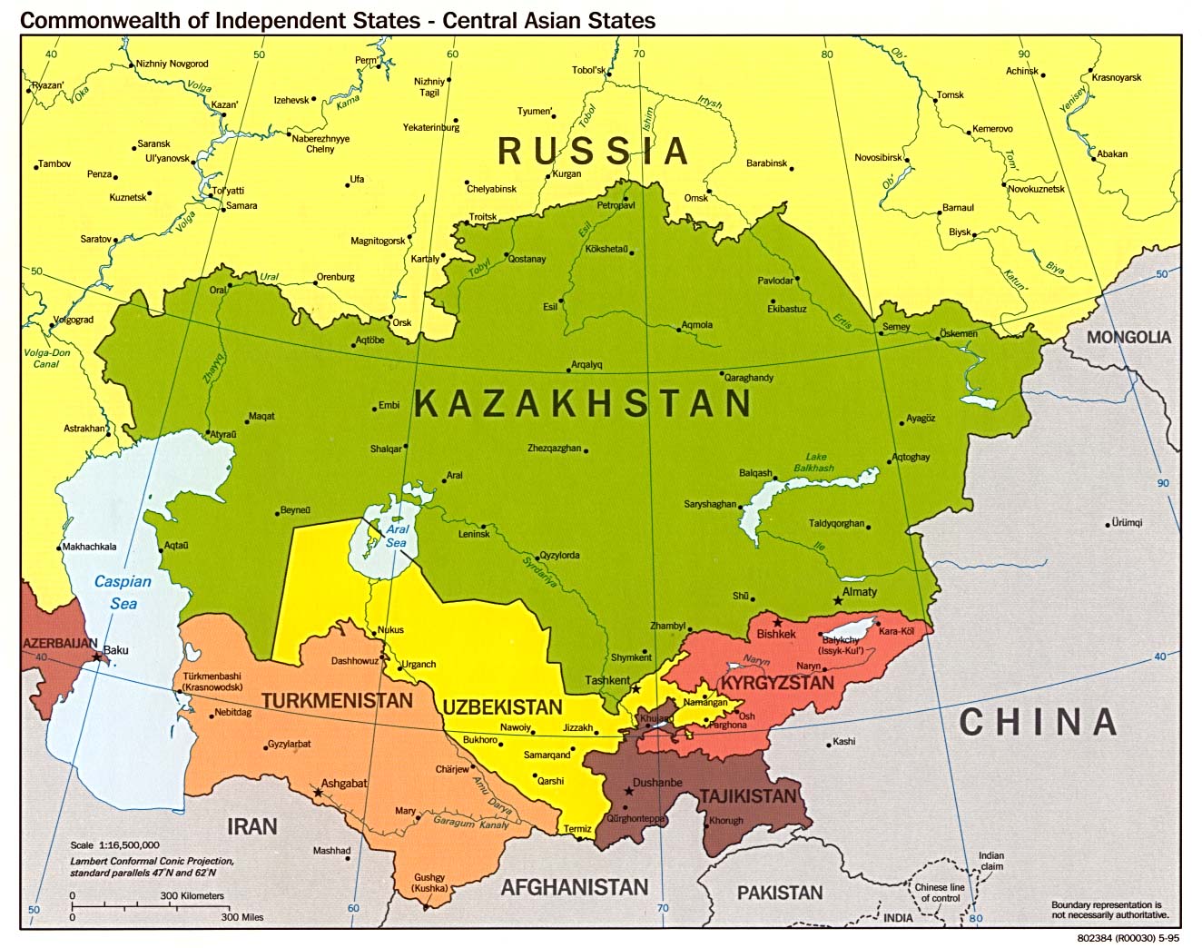
The independence of the former Soviet republics of Central Asia (Fig. 1) has put before them a number of major and serious problems for the development of market economy. The background for this development is the specific geographical environment, made up mainly of desert areas with extreme climatic conditions, barren and sparsely populated. In 2011 Turkmenistan celebrated 20 years of independence. Since the establishment of a new state (1991) and declaration of its neutrality (1995), face of the country has changed significantly. In “a happy era of the mighty state,” proclaimed by President Gurbanguly Berdymukhamedov (Gurbanguly Berdimuhamedow), in water industry of the country, as in other sectors of economy, there are significant transformations. Water industry development has become one of the priorities of the state policy. In arid conditions, as a rule, water resources are very limited; therefore the conservation and management of water resources is a priority when discussing plans for economic and social development of the countries of Central Asia.

The map of Central Asia (http://www.lib.utexas.edu/maps/commonwealth/cis_central_asia_pol_95.jpg)
Water is vital for Turkmenistan, the country where 80% of territory is covered by one of the world’s largest deserts Karakums. Its availability is vital for the development of irrigated agriculture and water supply for population. The main source of surface water is the Amu Darya River, which through the Karakum Canal (also known as the Karakum River) brings together in a single complex the irrigation drainage systems of Lebap, Mary, Akhal, and Balkan velayats (provinces) (Fig. 2). In addition, the Amu Darya River meets the needs of Dashoguz Velayat. Most of the water resources of Turkmenistan are used to grow a variety of crops on irrigated lands – cotton, wheat, forage crops, vegetables, melons, etc. They are also used by industrial enterprises and utilities.

Turkmenistan and its hydraulic network
As a result of irrigation of fields for agricultural production, collector drainage waters (CDW) are formed. In order to maintain a good level of irrigated lands, it is required to drain water (usually mineralized) from irrigated fields beyond the agriculture zone. Deficit of irrigation water in agriculture can be compensated due to large stocks of mineralized groundwater and drainage water. The total volume of drainage water is estimated to be about 6 km3/year, and taking into account the volume of drainage water generated on the territory of neighboring Republic of Uzbekistan, this figure can reach over 11 km3/year. The total volume of drainage water discharged annually into Sarykamysh Depression (Sarykamysh Lake) and sands of the Karakum Desert is more than 6 km3 with an average mineralization of 3–5 g/l. Such water could potentially be used for growing crops, flushing of saline soils, and irrigation of desert pastures.
Drainage waters forming on the irrigated lands of Turkmenistan and those coming from Uzbekistan cause a number of ecological problems for the environment:
-
1.
Runoff of drainage waters from Turkmenistan and Uzbekistan back to the Amu Darya River, and, as a consequence, the deterioration of water quality in the lower reaches of the Amu Darya River.
-
2.
The negative impact of the CDW extra discharge from the territory of the Republic of Uzbekistan on the irrigated lands of Dashoguz Velayat via the interstate Ozerny and Daryalyk collectors. This causes an increase in the water levels in the CDW collectors and reduction in the efficiency of the drainage systems in the area of their influence.
-
3.
Elevation of the water table on the reclaimed lands, which, coupled with the deteriorating quality of irrigation water, speeds up salinization of the lands and a sharp decline in their fertility. It also eliminates the possibility of efficient desalination of lands as washing does not bring tangible results. As a result, irrigated lands become very strongly saline and cannot be used further for agricultural processes.
-
4.
In the absence of receiving water reservoirs for CDW drained from irrigated fields in Mary, Akhal, and Balkan velayats of Turkmenistan, it was decided to temporarily dump CDW into the Karakum Desert, where there was flooding of lands and pastures. This decision led to a negative impact on the ecology of the flooded pasture lands.
As can be seen from all of the above-mentioned environmental problems related to CDW, Turkmenistan alone is faced not only with domestic water management issues, such as preventing the shrinking of grazing areas and protection of the Central Karakum from flooding by CDW, but also with interstate issues related to prevention of CDW discharge into the Amu Darya River. Currently CDW are discharged into the Amu Darya River, Sarykamysh Lake, and low places in the desert.
To solve this problem with CDW discharge, in 1960s creation of the Trans-Caspian collector was suggested, which had to collect all the drainage water from the Murghab, Tedzhen, and other irrigated areas and forward them to the Caspian Sea. In 1970s, a new project was elaborated which was aimed to discharge CDW into the closed Karashor Depression (Fig. 2). It was planned to forward CDW from Tashauz (now Dashoguz) to Karashor via ancient Uzboy river bed beside the Sarykamysh Lake. Second, the Main Turkmen Collector 720 km long was planned to build from Chardzhou (now Turkmenabad) through the center of the Karakum Desert along the river bed of the ancient Amudarya (along Unguz salt marshes) (Fig. 2). It was supposed to extend the Murghab and Tedzhen river beds to the Main Collector. Another collector was planned from the Kopetdag Plain to Karashor Depression. In the early 1980s construction of this hydraulic network began, but then was stopped due to the collapse of the USSR.
The National Program “Strategy of economic, political and cultural development of Turkmenistan until 2020” shows the construction of the Turkmen lake “Altyn Asyr” as one of the priorities in the country. It will allow:
-
1.
To prevent the discharge of CDW in the Amu Darya River, improve water quality in the river, and, thus, radically change the current negative environmental situation in the lower reaches of the river.
-
2.
To gather into a single stream all CDW from irrigated lands of Dashoguz, Lebap, Mary, Akhal, and Balkan velayats and direct them into the Karashor Depression – future Altyn Asyr Lake.
-
3.
To use 400,000 ha of flooded desert pastures in agriculture.
-
4.
To decrease by 2 m water level in the Ozerny and by 1.2 m in the Daryalyk collectors, ensuring normal operation of drainage systems in Dashoguz Velayat.
-
5.
To use the supplementary drainage collectors for irrigation of pastures, which will increase their water supply and productivity in the area of 1.3 million hectares.
-
6.
To reduce the discharge of CDW into Lake Sarykamysh and decrease the lake level to a stable point – −9 m, which will reduce the water area of the lake and shrink large areas of shallow water.
-
7.
To reduce the threat of destruction of transport communications (gas pipelines, road bridges, aqueducts, etc.) in Dashoguz Velayat.
According to the general plan, the total length of the collectors of the Turkmen lake “Altyn Asyr” is over 2,650 km, the area of influence of collectors is around 2.5 million hectares, the construction period – about 10 years [1]. Construction of the Turkmen lake began in 2000. By 2008 Dashoguz collector of 385 km long was built. Also two water dams of 600 m and 22 km long were constructed. The confluence of two collectors will be connected with Karashor Depression with a canal of 74 km long. The first phase of the hydraulic network was put into operation in 2009. Work is underway on the supply Murghab, Tedzhen, and Dzharsky collectors.
The construction is designed in three phases. Upon completion of the second and third stages, in Turkmenistan a single drainage system will be constructed. The total length of the main and secondary collectors will reach 2,654 km. The length of the Turkmen lake “Altyn Asyr” is planned to be 103 km, width – 18.6 km, average depth – 69 m, capacity – 132 km3, and area – about 2,000 km2. Up to 10 km3 of CDW is planned to forward to the lake. It is expected to withdraw CDW from Dashoguz Velayat with a rate of 210 m3/s, and from the Lebap, Mary, Akhal, and Balkan provinces another 240 m3/s. Filling the lake would take about 15 years and $4.5 billion. Realization of this ambitious project will solve many social, ecological, and economic problems in the nearest future [1].
In June 2012, speaking at the Academy of Sciences of Turkmenistan, President of the country Gurbanguly Berdymukhamedov has highlighted the importance of one of the tasks of the Project: “the development of technology for effective use of the Altyn Asyr Lake, its tributaries and adjacent lands in agriculture and socioeconomic area.” In his publication “Economic strategy of Turkmenistan: Relying on the people, for the people,” President G. Berdymukhamedov writes “…Our trump card in the set of solutions to this problem is water.” From the ancient times, Turkmens cherish water as the most precious wealth, measuring every drop of water on weight of gold. Our ancestors created a unique irrigation system with a unique “kyariz” method of irrigation. Today, based on the folk traditions to lead a deal to its logical conclusion, we have to solve the problem of water supply in a complex with commissioning of fallow lands and ecological safety on a regional scale. The Turkmen Lake “Altyn Asyr,” already stretching for hundreds of acres in the center of the Karakum Desert, will serve to this important goal.
In a sense, Turkmenistan is a country of the experiment – scientific and engineering experiment devoted to delivery of water to the areas where it is needed to solve the agricultural and socioeconomic problems. The first experiment in 1950s was the construction of the Karakum Canal (now called the Karakum River) with a length of about 1,450 km. Its route was twice subject to change. Construction of the canal had an important impact on the overall economic development and improvement of social conditions of the population in Turkmenistan.
As in the case with the construction of the Karakum Canal, the world practice has a little experience in CDW transport for hundreds of miles. We can mention the project to the drain CDW from the San Joaquin Valley in California, USA to the San Francisco Bay via 302 km long collector. Therefore, such a big project like Turkmen Lake “Altyn Asyr” attracts a great interest of specialists, scientists, and ecologists from different countries. It acts as a natural model, the study of which will provide theoretical and practical bases for the use of mineralized water in the desert development taking into account the environmental safety.
Implementation of this huge water project, which has no analogues in the world, faces difficult problems today and even more problems may occur during its operation, as it was the case with the Karakum Canal. Today, some of the foreign press, specialists from different countries, and international organizations show criticism in relation to implementation of the “Altyn Asyr” Project [2]. The main concern of specialists is about environmental consequences of the project. It seems that it is a bit premature, as the project is still underway. By the end of 2012 there are still hundreds of kilometers of collectors to be constructed and the Karashor Depression is still empty. It will take about 15 years to fill it.
In this book we would like to inform the international scientific community about this great project in Turkmenistan, describe its details, show the results of the ongoing research, especially in satellite monitoring [3–6], and invite for cooperative research. To understand the idea of the project and of the construction of the Altyn Asyr Lake, it is required to analyze the country’s water resources, and to focus attention on those that are used or could be used for the development of agriculture. Thus, the book includes chapters on general environmental conditions, Karakum Desert, water bodies and resources in Turkmenistan, groundwaters, and regional climate change. Special chapter is devoted to international cooperation of Turkmenistan in water sector. Previous water projects implemented in Turkmenistan – the Karakum Canal and Sarykamysh Lake – are described in detail. The Altyn Asyr Lake issues are in the focus of the book: from new morphometric characteristics of the lake, computed based on the three-dimensional digital elevation model of the Karashor Depression, to forecasts for its water and salt balance, future ichthyofauna and waterbirds, which will live in the hydrographic network of the Altyn Asyr Lake. Special attention is given to the ongoing satellite monitoring of water resources in Turkmenistan and the construction of the hydrographic network in the vicinity of the Karashor Depression, which we are working on since 2009.
In this book we combined efforts and expertise of an international team of specialists in different fields of natural, social, and political sciences from Turkmenistan, Russia, Ukraine, France, USA, and Israel. The publication is based on observational data, scientific literature mainly published in Russian editions, and long-standing experience of some of the authors in the scientific research in Turkmenistan. The authors did not try to achieve unanimity on the Altyn Asyr Lake Project, and sought to reflect personal professional opinion to the issues discussed.
This is the first book about the Altyn Asyr Lake published in Western Edition, thanks to Springer-Verlag Publishers who supported our idea. Undoubtedly, it will be followed by others, upon the progress in the implementation of the project and filling the Karashor Depression with CDW. We hope the book will become a milestone in the realization of the project, which in July 2014 will celebrate 5 years since the beginning of filling the new hydrographic network by CDW. This book is addressed to the specialists working in various fields of environmental problems and ecology, water resources and management, land reclamation and agriculture, and regional climate change in Turkmenistan and Central Asia.
This book may be regarded as a follow-up volume to our previous books on Central Asia published in Springer-Verlag: “The Caspian Sea Environment” (2005), “The Aral Sea Encyclopedia” (2009), “The Aral Sea Environment” (2010), and “The Caspian Sea Encyclopedia” (2010) [7–10]. On behalf of the authors, we would like to thank Springer-Verlag Publishers for their timely and steady interest in the environment of the Central Asia and their support of our publications.
Finally, we would like to note that in this book readers will find the same geographical terms written in a different way. For example, a capital of the country is written as Ashkhabad, Ashgabat, and Ashgabad. Amu Darya River sometimes is written as Amudarya, etc. This is explained by two reasons. First, after declaration of independence of Turkmenistan in 1991, there was a change in many geographical names and names of cities in the country. Thus, Chardzhou town became Turkmenabat, Nebitdag – Balkanabat, Krasnovodsk – Turkmenbashi (as well as Turkmenbashi Bay and Peninsula), Tashauz – Dashoguz, Kazandzhik – Bereket, Karakum Canal – Karakum River, etc. Second, in some cases this is due to different transliteration from old and new names in Russian (Cyrillic letters), in other cases – from Turkmen Language (Latin letters). Standardization of spelling of the Turkmen names and terms in English is a big task, which is outside of the scope of this book; moreover all the names and terms used in this book are today encountered together in Turkmenistan. We hope this will not lead a reader to confusion.
References
Turkmen Lake (2010) “Altyn Asyr”, Ashgabat, p 104 (in Turkmen, Russian and English)
Stone R (2008) A new great lake – or dead sea? Science, v. 320
Kostianoy AG, Lebedev SA, Solovyov DM (2011) Satellite monitoring of water resources in Turkmenistan. Int Water Technol J 1(1):4–15
Kostianoy AG, Lebedev SA, Zonn IS, Lavrova OYu, Solovyov DM (2011) Satellite monitoring of Turkmenistan, Moscow, Signal, p 16 (in Russian and English)
Kostianoy AG, Zonn IS, Solovyov DM (2012) Construction of the Turkmen lake «Altyn Asyr» and the results of its satellite monitoring in 2009-2011. Int Water Technol J 2(1):59–66
Kostianoy AG, Zonn IS, Solovyov DM (2012) The Turkmen Lake “Altyn Asyr”: satellite monitoring of its construction. Modern problems of remote sensing of the Earth from space. 9(1):219–227 (in Russian)
Kostianoy AG, Kosarev AN (eds) (2005) “The Caspian Sea Environment”. The handbook of environmental chemistry. Vol.5: water pollution, Part 5P. Springer, Heidelberg, p 271
Zonn IS, Glantz M, Kostianoy AG, Kosarev AN (2009) “The Aral Sea Encyclopedia”. Springer, Heidelberg, p 292
Kostianoy AG, Kosarev AN (eds) (2010) “The Aral Sea Environment”. The handbook of environmental chemistry. Springer, Berlin, V7, p 332
Zonn IS, Kostianoy AG, Kosarev AN, Glantz M (2010) “The Caspian Sea Encyclopedia”. Springer, Berlin, p 527
Author information
Authors and Affiliations
Corresponding author
Editor information
Editors and Affiliations
Rights and permissions
Copyright information
© 2013 Springer-Verlag Berlin Heidelberg
About this chapter
Cite this chapter
Zonn, I.S., Kostianoy, A.G. (2013). Introduction. In: Zonn, I., Kostianoy, A. (eds) The Turkmen Lake Altyn Asyr and Water Resources in Turkmenistan. The Handbook of Environmental Chemistry, vol 28. Springer, Berlin, Heidelberg. https://doi.org/10.1007/698_2012_218
Download citation
DOI: https://doi.org/10.1007/698_2012_218
Published:
Publisher Name: Springer, Berlin, Heidelberg
Print ISBN: 978-3-642-38606-0
Online ISBN: 978-3-642-38607-7
eBook Packages: Earth and Environmental ScienceEarth and Environmental Science (R0)