
Abstract
Statigraphic exposures, fluvial archives and borehole data have been allowed to reconstruct the alluvial history of Late Pleistocene to Early Holocene and climate changes in the monsoonal wet–dry region of lower Damodar Basin (West Bengal, India). The facies architectures and climate proxies suggest that five to six climate changes occurred in between ∼14 and 6 kiloannum (ka). Supporting evidence from the floodplain of Damodar River demonstrates that the successive phases of aggradation and incision were linked to the south-west monsoonal variability of Late Quaternary period. The onset of semi-arid climate was associated with caliches, pond and backswamp deposits of waning low-energy floods. The relatively warm-humid climate was associated with sandy bedforms, valley fills, slack water deposits and ferruginous nodules. This paper presents a synthesis of the available palaeoclimatic records from the lower Ganga Basin and the rivers of western and central India for the palaeoenvironmental significance of Late Quaternary deposits and discusses the influence of palaeoclimatic controls on the fluvial architectures and archives that developed below the floodplain of Damodar River. We have taken some representative studies from the region to reveal the spatial variability in fluvial successions in response to climate changes during this period.
Introduction
The major river basins of India are considered as the important repository of the Late Quaternary hydrological and climatic changes (Sridhar 2008). Fluvial systems have been found to be the most sensitive elements of the earth’s surface, and any shift in climate and environmental conditions instigates a rapid response from the fluvial systems (Sridhar 2008; Kale et al. 2010). The long- (millennial scale) and short-term (centennial scale) alteration in hydrology, morphology and sedimentation pattern of the river basins can be reconstructed through the palaeo-records of river planform modifications and sediment deposits that occur during the extreme flood events of monsoon (Sridhar 2008; Singhvi and Kale 2009). The word ‘palaeo hydrology’ probably first used by Leopold and Miller (1954), Schumm (1965, 1977) and Cheetham (1976), is defined as the study of fluvial processes operated in the past and their hydraulic implications (Garde 2006). Then the term ‘palaeoflood hydrology’ coined by Kochel and Baker (1982) has amplified the horizon of palaeoflood hydrological research, dealing with ancient flood deposits (Baker 2006). Kale et al. (2010) suggested that the intensification of the monsoon during the early Holocene (∼10 ka) had a dramatic and profound effect on the fluvial system of Indian subcontinent, inducing immense wet monsoon flood flows (Kale et al. 2010). Those fluvial archives of palaeofloods and palaeoclimate were well preserved in the river floodplain which is a strip of relatively smooth land bordering a stream and overflowed at the time of high water and was continuously constructed and destroyed by different fluvial regimes since Quaternary Period (Leopold et al. 1969; Schumm 1977; Singhvi and Kale 2009). Sedimentary records of large magnitude floods during the Early to Middle Holocene have been reported from a few monsoon-fed rivers, such as Narmada, Tapi, Mahi, Saraswati, Luni, Pennar and upper Kaveri rivers (Sridhar 2008; Singhvi and Kale 2009; Kale et al. 2010). Kale and Rajaguru (1987), Rajaguru et al. (1993), Rajaguru et al. (1994), Chamyal et al. (1997), Joshi and Kale (1997), Kale et al. (2003), Singh (2004), Sinha et al. (2005), Sridhar (2008), Jaiswal et al. (2009), Singhvi and Kale (2009), Sinha and Sarkar (2009), Kale et al. (2010), Sinha and Ghosh (2012) and other renowned persons have gone through deep investigation on the alluvial stratigraphy and Quaternary sedimentology in the river basins of western India and Ganga Basin to get idea on palaeoenvironment. It is therefore reasonable to assume that the major rivers of West Bengal (coming from Chotanagpur Plateau) might have also responded to the Pleistocene to Holocene climate changes almost in the same way that can be analysed by palaeoflood sedimentology.
Reconstruction of past climate needs a ‘climate proxy’ which is a physical, chemical or biological attribute of the natural system enabling to quantify the change in climate in the past (Singhvi and Kale 2009). ‘Fluvial archives’ are the riverine sediment and especially slack water deposits of floodplain which bear the evidences of palaeoclimate and palaeohydrology (Baker and Kochel 1988; Singhvi and Kale 2009). Terrestrial palaeoclimatic proxies of western India include riverine deposits and flood sediments (fluvial archives) which indicate distinct periods of erosion, incision and aggradation associated with changes in the monsoon conditions and sediment supply (Rajaguru et al. 1993; Singhvi and Kale 2009; Sinha and Ghosh 2012). The stratigraphic record of Quaternary floodplain sediments is the fundamental database for understanding the palaeoenvironment and global climate change (Brakenridge 1988; Nichols 2009). One of the objectives of sedimentological studies is to try to create a reconstruction of what an area would have looked like at the time of deposition of a particular stratigraphic unit (Nichols 2009). As records of Late Pleistocene and Holocene sediments of India indicate different monsoonal hydrologic regimes (alternate wet and dry periods) than those we experience today, the Damodar River should responded to that external changes, specifically through the occurrences of floods and weathering of overbank deposition (Hayden 1988; Brakenridge 1988). The prime objective of this study is to unfold the alluvial history of Quaternary morpho-stratigraphic units and to correlate between Quaternary climate changes and alterations in the fluvial regime in the floodplain of Damodar River (West Bengal, India).
Study area
The Damodar River Basin is a sub-basin of the Bhagirathi-Hooghly River system of West Bengal. Its funnel-shaped basin area is about 23,370.98 km2, spreading in the states of Jharkhand (73.7 %) and West Bengal (26.3 %) (Majumder et al. 2010). The River rises in the Chotanagpur Plateau (Khamarpat Hill near Chandwa in Palamau district) approximately at 23°37′ N and 84°41′ E (Sen 1985; Chandra 2003; Bhattacharyya 2011). Near Palla village (close to Chanchai rail station), the lower reach of Damodar takes an abrupt southerly 90° bend (fault guided) and below Jamalpur, the River bifurcates into the Kanki-Mundeswari and the Amta Channel-Damodar and joins with Hooghly River (also spelled Hugli) at Falta some 48.3 km south of Kolkata City (Bhattacharyya 2011; Ghosh and Mistri 2012). Damodar River deeply incise the faulted Gondowana uplands of Jharkhand, following Raniganj Coal-Belts and Lateritic Rarh Plain of West Bengal, and after that it forms the older and newer alluvial plains of Pleistocene and Early Holocene ages respectively in the lower valley, developing a fan-delta toward east (Acharyya and Shah 2007). Flanked by the Pleistocene terraces and Tertiary rocks to the west and north, the Bengal Basin covers the eastern parts of West Bengal (India) and most of Bangladesh and the west to east flowing rivers of Chotanagpur Plateau, viz. Damodar, Ajoy, Dwarkeswar, Mayurakhi, Dwarka, Brahmani etc. are the main contributors of relatively coarse sediments into the Bengal Basin through Holocene floods (Alam et al. 2003; Das Gupta and Mukherjee 2006).
Away from the basaltic outcrops in the Rajmahal Hills, similar Upper Jurassic to Late Cretaceous lava flows have been encountered in a number of deep-wells within the western part of Bengal Basin which acts as the basement of Pliocene–Miocene sedimentation along lower Damodar River (Sengupta 1972; Alam et al. 2003; Kuehl et al. 2005; Dasgupta and Mukherjee 2006). The excessive sedimentation was started from Silla (near Galsi) because a perpendicular (south to north) Basin Margin Fault created sudden fall of the underlying basement and two major faults (south–north) directed the southern course of Damodar River from Palla (Dasgupta and Mukherjee 2006).The Ajay River located further north, still flows east to meet the Bhagirathi River, which was the regional fault-guided slope also followed by the ancient Damodar and its growth of fan-delta (Acharyya and Shah 2007 and 2010). The sediments of Damodar fan-delta have their origin from the Chotanagpur Granite–Gneiss and Gondwana Formation and the river system of Damodar debouched the sediments in a palaeo-shelf environment of Bengal Basin since Miocene (Singh et al. 1998).
For field investigation, we have selected the lower segment (23°00′ to 23°22′ N and 87°28′ to 88°01′ E) of Damodar River in between Rhondia Andersion Weir below Durgapur Barrage (west) and Paikpara below Jamalpur (east) (Fig. 1). The detail geological study has carried in the left-bank floodplain of Damodar River (in between Belkash and Barsul, covering Barddhaman town), because in this flood-affected region, numerous glimpses of Late Quaternary landforms viz., alluvial terraces, mature point bars, avulsion, spill channels and palaeochannels (Khari, Banka, Gangur, Behula, Sapjala, Deb Khal, Kana Damodar etc.) are found.

Location map of Damodar River Basin including the study area
Methods and materials
One of the powerful tools we have for predicting future climate is the special record or signature in the rock or alluvium strata of local and global changes over periods of thousands to millions of years. Floodplain stratigraphy provides the time frame that allows us to interpret sedimentary deposits in terms of dynamic evolving environments (Nichols 2009). The term ‘facies’ is used here to refer the individual characteristics of each sedimentary unit, and by recognising associations of facies, it is possible to establish the combinations of processes that are present (Nichols 2009). The earlier concept stratigraphy study concerning vertical pile-up of sediments is now outdated. It is both vertical as well as horizontal accumulation of sediments (Rajaguru et al. 1994). Assuming that the laws that govern physical and chemical processes have not changed through time, detailed measurements of Quaternary sediments can be used to make estimates of the physical, chemical and biological conditions that existed at the time of sedimentation and post-depositional environment (Einsele 1992; Nichols 2009).
Naming of distinct layers of lithologs or bore-holes the term formation is not used here according to strict definition of International Stratigraphic Code. These are essentially different litho-units associated with certain fluvial processes, flow power and pedogenic processes (Rajaguru et al. 1993). To make a satisfactory analysis of sedimentary environment, a reliable geological database is prepared from two unpublished reports of Geological Survey of India (GSI; Eastern Region, Kolkata), entitled ‘A report on geo-environmental appraisal in Barddhaman urban agglomeration area and its Environment for sustainable developmental activities’ (2005) and ‘Quaternary geological and geomorphological mapping in parts of Barddhaman and Bankura districts’ (1990), respectively. Stratigraphical studies are carried out at the selected sites, having 9.0-m sub-surface lithologs (Fig. 2). Near-surface sediment characters of the litho-units, we have studied the truncated profiles of river bank and different landforms like levee, backswamp, abandoned channel and point bar. Depositional environment and channel configuration have been deduced on the basis of sedimentological characters of fluvial deposits. A lithofacies classification similar to that developed by Miall (1985, 1996) and Einsele (1992) have been adopted for the present purpose. The graphic sedimentary logs (1:100 scale) are prepared following Tucker (1996) formats to present sub-surface data in a way which is easy to recognise and interpret using symbols and abbreviations prepared by Nichols (2009). Other secondary data and spatial information are mostly collected from Damodar Planning Atlas (Chatterjee 1969), book entitled ‘Lower Damodar River, India: understanding the human role in changing fluvial environment’ (Bhattacharyya 2011), official Website of Irrigation and Waterways Department of West Bengal, topographical sheets (73M/7, M/11, M/12, M/15, M/16, N/13 and 79 A/4, 1969–1974) of Survey of India, District Resource Map (GSI), SRTM data (2006) and lastly most important Landsat satellite images of 1972, 1990, 2000 and 2006 (MSS, TM and ETM+).

Sample locations of shallow bore holes in the study area
Quaternary floodplain facies and geomorphic change
The Quaternary Period is the fourth and the latest geological period that commenced about 2.6 million years ago, and it is divided into Pleistocene Epoch (2.6 million years to 11,500 years before present) and Holocene Epoch (began about 11,500 years ago and continues to the present) (Nichols 2009; Singhvi and Kale 2009). About 50 Ice Ages (or glacial periods) and equal number of intervening warmer periods (or interglacial periods) have occurred during the last 2.6 million years (Singhvi and Kale 2009). Thus, it is quite natural that India has experienced variable monsoon from Pleistocene and consequently it has influenced differently the hydrologic regime, magnitude of floods and sedimentation processes of Indian rivers. Floodplain stratigraphy and facies development (periods and aggradation and degradation) are well associated with variations in the river flood regimes (Schumm 1977; Brakenridge 1988).
As a result of both channel lateral movement (lateral accretion) and suspended load deposition (overbank deposition), Damodar River bed and floodplain include the following two assemblages of Quaternary sedimentary facies (Wolman and Leopold 1957; Gregory and Walling 1973; Faniran and Jeje 1983; Brakenridge 1988):
-
1.
Channel bed deposits—channel lag, point bars, longitudinal bars and channel fills facies, and
-
2.
Bank and overbank deposits—levees, backswamps, crevasse splays and terrace facies.
Through identification of the fluvial features from the toposheet (73 M), SRTM data (2006), Landsat TM image (2006) and Google Earth (2012), a Quaternary floodplain map of Damodar River is prepared to depict the distinct association and location of floodplain geomorphic features (Fig. 3). It is evident that the longitudinal islands, sand bars, river bed and asymmetric terraces are associated to the depositional environment of Late Holocene to the Present (∼6 kiloyears (kyr) to the present) whereas the point bars, backswamps, levee, sloughs, palaeochannels and spill channels are developed in Middle Holocene to Late Holocene (∼ 9 to 6 kyr).

Quaternary floodplain features of lower Damodar River (Rhondia to Paikpara)—upper valley is dominated by elongated point bars, longitudinal islands and terraces and lower valley is dominated by levee and palaeochannels
Due to lateral accretion and avulsion, numerous glimpses of point bars and longitudinal bars (locally named as ‘char’ and ‘mana’) are now fully matured and used as settlements and agricultural lands which are well observed at Fathepur mana, Godinapur mana, Satyanandapur mana, Belkash, Chanchai, Paikpara etc. (Fig. 3). Most of the point bars are built up from layers of coarse sands (upward fine sequence) and perhaps with some gravel, they have layers of sand pointing downstream (Allen 1970; Gregory and Walling 1973). Lag deposits are coarse grained and discontinuous bars laid down behind the barriers or along the sides of channel. These are the result of deceleration of flow causing lack of competence so that larger particles are dropped from the bed load, mainly in riffles (Allen 1970; Gregory and Walling 1973; Garde 2006). Near Somsar village (below the confluence of Sali River) a fully matured large longitudinal island/bar, named ‘Majher Char’, is developed due to coalescence of point bars stabilised with vegetation. The lateral accretion and channel bed deposition account for as much as 80 to 90 per cent of floodplain deposits whereas the remaining 10 to 20 % are overbank deposits (Wolman and Leopold 1957).
Well-developed stretch of floodplain levee is observed in between Barddhaman and Paikpara showing dominance of coarser materials carried by turbulent flood water. It is observed that rapid vertical accretion of the levee lead to a situation where a depression exists between it and the bluff of the floodplain. Such a depression, subject to regular inundation (deposition of clay and silt), is denoted as backswamp (Allen 1970; Faniran and Jeje 1983). The thick cover (3 to 4.5 metre from surface) of backswamp deposits (from Belkash to Barsul) is developed in Middle to Upper Holocene and it is the sign of frequent overbank flow in the monsoonal floods. These deposits are slowly formed by colloidal clay and fine silt particles (source area of slack water deposits) together with organic and in-solution materials (Gregory and walling 1973; Bridge 2003). Presence of abandoned channels of ancient Damodar River is an indicative of direction of shifts and older flood ways. Some spill channels or ‘Hanas’ (associated with sand splays) are observed on the right side of lower Damodar River, viz. Deb Khal, Kamargaria Khal, Mhonapur Khal etc. It indicates the breaching of former embankments because of extreme flood flow.
The Damodar River had formed two Quaternary alluvial fans in between Late Pleistocene and Late Holocene: (1) the Memari fan trending east and (2) the Tarakeswar fan trending south. These fan surfaces are broardly equivalent to the Kalna Plain or Younger Delta Plain (YDP) (Acharyya and Shah 2007, 2010). The geomorphic features of the Kusumgram Delta Plain, equivalent to Older Delta Plain (ODP) are revealed by the presence of mature points bars, terraces and abandoned channels bifurcating from the Damodar River around Silla (located about 30 km upstream of Barddhaman town), which was the apex of the Damodar fan-delta of Pleistocene Epoch (Acharyya and Shah 2007). The geomorphic feature of YDP is demonstrated by the presence of a system of eastward and south-eastward flowing abandoned channels \, which bifurcated from Barsul (Acharyya and Shah 2007, 2010). The base of the Quaternary section is difficult to identify, but in many boreholes near the western upland a sequence of dominantly clay and sand having saline formation and locally containing micro-fossils have been assigned Upper Pliocene age (Acharyya and Shah 2007).
Morpho-stratigraphical units of floodplain
Geologically the floodplain of this area belongs to the western part of Bengal Basin and geomorphologically it is a mature fan-delta of Damodar River sloping towards east-south east, though its western part is associated with Ajoy-Damodar Interfluve, i.e. Rarh Plain (Alam et al. 2003; Acharyya and Shah 2007). Regional stratigraphy reveals that from Late Pleistocene to Recent three Quaternary Morpho-Stratigraphical Units or litho-facies are developed in respect of palaeo fluvial depositional environment, viz. Sijua, Chuchura and Hooghly Morpho-stratigraphical Units (Bhattacharya and Dhar 2005). The aforesaid Quaternary floodplain facies or landforms are distinctly associated with the following three main litho-units:
-
1.
Hooghly morpho-stratigraphical unit (HMU)—mid-channel bars, point bars, valley fill and abandoned channel and chutes;
-
2.
Chuchura morpho-stratigraphical unit (CMU)—levee, backswamp, mature point bar and palaeochannels; and
-
3.
Sijua morpho-stratigraphical unit (SMU)—undulatory surface with older alluvium.
-
(a)
Hooghly morpho-stratigraphical unit
HMU comprises recent sediments (active alluvium) on present day floodplain of Damodar River and is developed in Late Holocene (∼6 kyr to the present). Lithologically the sediments are the aggregates of coarse to medium grained pale yellow to light grey sand mixed with brownish grey silt and occasional presence of black clay or mud deposits. This type of sediment is defined as the active alluvium transported by the stream flowing of flood-scour of the modern channel, and the maximum grain size which the stream can competently transport at a flood-stage (Faniran and Jeje 1983). Occasionally sands of point and mid-channel bars show approximately 1.5-m thickness in each laminated macro lithofacies. The deposition of fine sand, coarse sand, medium sand with presence of silt and clay are occurred as laminated, planner, cross-laminated sedimentary facies. Trough and planar cross-bedded sand deposits (fining-upward channel fills cause distinct minor sedimentary cycles) is found in the mid-channel and point bars (Rajaguru et al. 1993). Horizontally stratified sand signifies upper flow regime and lower flow regime causes trough cross-stratified grey sand, planar cross-stratified sand, ripple marks and small-scale cross stratification (Miall 1996; Bridge 2003; Nichols 2009).
Inter-bedded silt-clay deposition (Fig. 4b) in the sand dominated lithofacie signifies the very low flow regime and slow deposition of stagnant water (Fsc). Deposition of coarse sand, pebbles, gravels and shells denotes the channel lag deposits (Fig. 4c), having minor channel fills in the time of lateral accretion of point bar (Gt). Horizontal lamination of fine to coarse sands (Fig. 4a) show planner bed flow (Sh) and low-angle cross-bedding (<10°) of sands denotes scour fills and antidunes (Sl). Short-term changes occur during monsoonal flash floods, and long-term changes reflect aggradation and reduction in water depth (Miall 1985; Rajaguru et al. 1993). In short sand dominated HMU of Damodar River has assemblages of dunes (St), sand waves, linguoid and transverse bars (Sh) and ripple marks (Sr).
Fig. 4 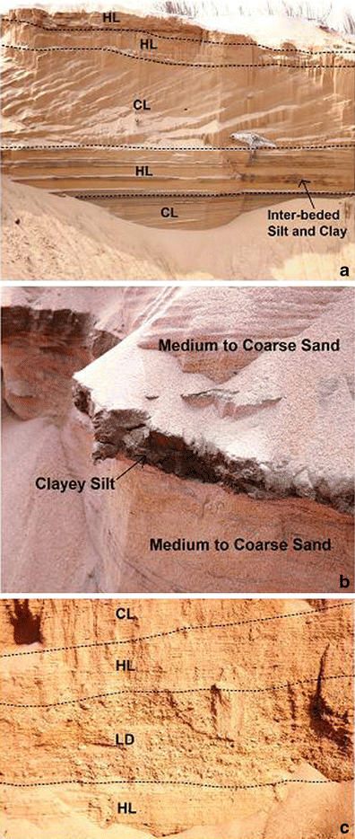
Fluvial architectures of HMU—a horizontal and cross-bedding lamination (dunes and anti-dunes) of pale yellow sands having horizontal inter-bedded silt and clay deposits at Palla (23 km downstream from Bardhaman town); b inter-bedded brownish black clayey silt deposits (Fsc) in between layers of medium to coarse sands at Palla; c brownish wavy lag deposits (Gt) in between horizontal laminated coarse sands at Rhondia (Note: HL horizontal lamination, CL cross lamination, LD lag deposit)
-
(b)
Chuchura morpho-stratigraphical unit
CMU is well exposed in the low lying areas (adjoining river bank) of Barddhaman town along the left bank of Damodar River. This unit is developed in Middle Holocene to Late Holocene (∼9 to 6 kyr). Boundary between CMU and SMU is transitional and aggradational origin, having dominance of clayey silt and clayey sand (topmost part of lithofacies). The width of CMU is respectively about 2 and 6.5 km in the right and left banks of Damodar River, having glimpses of palaeochannels, mature point bars, crevasse splay, backswamps and sinuous arrangements of water bodies. The fluvial sediments of CMU are represented by sparsely oxidised grey to brownish grey, micaceous silty clay, clayey silt and sandy silt with irregular brownish patches and ferruginous concretion, grey to brownish grey fine to coarse sands with few pebbles and gravels.
Geomorphologically, the study site (SBH 1), located at Bam (23°13′15″ N and 87°54′29″ E), is situated on the terrace of mature point bar, showing 1.2 m of overbank deposits (suspended load in palaeofloods). Up to a 6-m depth, there is an upward fine sequence but below it is marked by some irregularities in sedimentation processes (Fig. 6). Occurrence of brown clayey silt (Fm) and silt (Fl) denotes the overbank or waning flood deposits, having desiccation cracks (Miall 1985; Bridge 2003; Garde 2006). Below this litho-unit, the deposits of fine sand (Sh) and medium sand with few pebbles (Sp) denote low flow regime of linguoid and transverse bar deposits (Miall 1985). Thereafter, almost 2 m thick of very coarse deposits of yellowish brown pebbles (Gm to Gt) bear the imprints of lag and sieve deposits in a crudely bedded form (Rajaguru et al. 1994). Again the occurrence of dark grey carbonaceous clayey silt horizon (at a depth of 7.3 to 7.9 m) carries the slackwater deposits of palaeofloods (Kochel and Baker 1988a, b; Kale et al. 2003; Thomas et al. 2007). The transition from Fm and St to Gm (coarsening upward) (Fig. 5) during the terminal Pleistocene to Late Holocene suggests a hydraulic differentiation of the system into distinct energy levels, coarser ones related to high and violent floods and finer ones are due to medium regimes (Rajaguru et al. 1993; Kale et al. 2003). The typical cycles of fluvial sedimentation of CMU include:
Fig. 5 
a Distinct lithofacies of CMU at Bam, showing upward finer sequence, overbank deposits (Fm and Fl), coarse lag deposits of pebbles (Gm), channel fills (Sp and Sh) and ferruginous correction of overbank palaeoflood deposits b upward fining sequence with thick deposition of valley fills (Sp) and pebbles (Gm) with top overbank pond deposits (Fsm) at Kala Nabagram (SBH-3), denoting high- to low-energy floods in between Middle to Late Holocene; and c up to 6-m overbank waning flood deposits with ferruginous concretion (weak monsoonal flow) and 6–9 m of valley fills (St), dunes (Sh) and lag deposits (Gm; strong monsoonal flow) at Baikunthapur (SBH-5)
-
1.
Gravel bars and bedforms (GB)–forset macroforms (FM)–sandy bedforms (SB)–overbank fines (OF)—6-m depth to the surface; and
-
2.
Laminated sand sheets–OF–SB—9- to 6-m depth
The study sites (SBH 3 and 5) at Kala Nababram and Baikunthapur, are located on the surface of concave levee and backswamp area respectively, underlying by the abandoned channel deposits (Fig. 5b, c). The thick layers (up to 3.5 m at SBH-3 and 6 m at SBH-5) of clayey silt, clayey sand and sandy clay (Fsm and Ft) carries the sign of waning flood deposits, including slack water deposits and ferruginous concretion. However, the disappearance of ferruginous concretion up to 3-m depth (at SBH-3) shows the Recent or Late Holocene flood deposits which are not present at SBH-5. At a depth of 4.2 to 4.5 (at SBH-3) and 8.7 to 9.0 m (at SBH-5), we have noticed a horizon of deep channel lag deposits (Gm) in between the deposits of scour fills, crevasse splay, antidunes and sand waves (Sp, Sh and St). The typical cycle of sedimentation of CMU include: GB–FM–SB–OF.
Few couplets of clayey silt and sandy silt deposits of CMU (Fig. 5) signify the occasional extreme flood events (high level of discharge–slack water deposits) of Late to Middle Holocene Epoch and presence of iron nodules (chemical alteration of ferruginous sediments) carries the sign of slow deposition in more humid and warm condition (Kale et al. 2003; Baker 2006). However, disappearance of iron nodules in both top lithofacies of Fm signifies the much younger palaeoflood deposits under stagnant water condition (suspended load) in mature point bars of both banks (Miall 1996). Bottom stratum refers to the relatively coarse sediments deposited on the Damodar Channel bed and preserved by burial during lateral migration of the channel and top stratums of the relatively fine sediments deposited on upper channel banks, on levees and on floodplain and terrace surfaces during infrequent high river stages of Late to Middle Holocene (Brakenridge 1988; Rajaguru et al. 1993; Nichols 2009).
-
1.
-
(a)


(c) Sijua morpho-stratigraphical unit
The SMU, relatively oldest lithofacies, was developed in between Late Pleistocene (∼25 to 11.5 kyr) and Early Holocene (∼11.5 to 9 kyr), having large spatial expansion of undulatory surface and terraces of older alluvium. The maximum thickness of this unit is 14 to 15 m, mostly covering Khari River Basin. This litho-unit is represented mainly by hard, sticky, brownish to yellowish grey clays enriched with caliche (calcareous concretion) with small rounded ferruginous. The SMU reveals that at 6- to 9-m depth, the clayey horizon (heavy suspended load) changes to sandy horizon (mixed bed load) in which fine to medium brownish grey sub angular quartz, altered feldspar and ferruginous concretion are observed.
SMU facies of Vita and Amarun (Fig. 6) are dominated by sticky clay and clayey silt (relative dominance of overbank fines) having distinct pedogenic layers of caliche and iron-concreted nodules. In SBH-2, up to 0.8-m two distinct lithofacies of Fm and Fl (disappearance of pedogenic nodules) are found, denoting very low fluvial regime and recent drape deposits formed in pools of standing water (Fig. 6a). In SBH-8, up to 2.7-m four distinct lithofacies of Fm to Fsm (with iron concreted and caliche nodules) grey, brownish grey and yellowish grey coloured sticky clay deposits are found which signify backswamp pond and waning flood deposits (Miall 1985). The presence thick clayey silt (Fl) with nodules denotes occasional slackwater deposits of high magnitude palaeofloods and post-flood stability of lithofacies in between Late Pleistocene and Early Holocene (Fig. 6b). The yellowish brown lithofacies (Sp, St and Ss) of denotes small channel, dunes, abandoned channel and scoured depression fills, but underlying greenish grey lithofacies of Fm and Fsm denote backswamp pond deposits (Einsele 1992; Garde 2006). In SMU during high magnitude palaeofloods, the water overtopped the banks to a point decided by the elevation of the flood waters such that at the terminal point the velocity of water is near zero (slack) and the sediments brought in suspension by the flood are then deposited by Stokes settling law, i.e. sands are deposited first followed by silt and then clays (Kochel and Baker 1988a, b; Thomas et al. 2007; Singhvi and Kale 2009). Importantly, greater thickness of sticky clay represents overbank deposition of high suspended load floods and suggests low lateral confinement, high sinuosity and a decrease in stream power (Rajaguru et al. 1993; Juyal et al. 2000). The alternate layers of caliche and iron nodules are the pedogenic formations of dry and humid fluvial environment respectively and these can be regarded as palaeosols and older alluvium of Damodar floodplain. The typical cycle of sedimentation of SMU include: FM–SB–OF.

Fluvial architectures of SMU—a alternate upward fining and coarsening sequence of sandy bed forms to overbank deposits denotes south west monsoonal variability and climate changes at Vita (SBH-2); and b occurrences of sticky clay and clayey slit with caliches suggesting relatively semi-arid climate with occasional wet period deposition of iron nodules in between Late Pleistocene and Early Holocene at Amarun (SBH-8)
It is understood that Damodar floodplain is distinctly composed of three morpho-stratigraphical units, ranging from newer to older alluvium with upward fining or coarsening sequences. Importantly, the distinct layers of clay and clayey silt of CMU and SMU provide an inference on the slackwater deposits of palaeofloods of Damodar and its distributaries. Mode of depositions of lateral accretion and overbank floods are associated with point bars, levee and backswamp which are reflected in the lithofacies (Fig. 7). As the successive floods overtopped the banks and active floodplain of Damodar River, one would expect successive increments of overbank deposition (principally sticky clay in SMU) on the floodplain to result in a continual increase in elevation of this surface relative to the elevation of streambed. As the floodplain gains higher elevation, presumably it would be flooded less frequently and get pedogenic stability (Wolman and Leopold 1957; Einsele 1992).

Typical depositions and settling of varying size of sediments in the floodplain of Damodar River, forming distinct lithofacies of HMU, CMU and SMU, respectively
Palaeoclimatic significance of CMU and SMU
With a focus on past twenty thousand years (∼20 kyr), perhaps the most important single climate factor is the monsoon and to an extent, palaeoclimatology in the Indian context is a synonym for the reconstruction of monsoon through time (Singhvi and Kale 2009). The palaeoclimatic studies of India indicate that there were distinct periods of erosion and incision (degradation) and sediment deposition (aggradation) associated with changes in the southwest monsoon (SWM) conditions and sediment supply (Mishra et al. 2003; Singhvi and Kale 2009). The main fluvial responses to Late Quaternary climate changes in India are (Rajaguru et al. 1993; Mishra et al. 2003; Kale et al. 2003; Thomas et al. 2007; Singhvi and Kale 2009):
-
1.
Periods of aggradation are linked to periods of weaker SWM, reduced coarse sediment supply and increased overbank fine deposition (suspended load) and
-
2.
Periods of stronger SWM are associated with erosion, valley incision and increased coarse sediment supply (bed load).
The response of each river basin in India to climate change has been different, and these differences arise because of different basin parameters, especially location of basin area and rainfall zone (Misra et al. 2003). At present the subcontinent of India is regionalised as Tszo flood climate region which signifies barotropy seasonal international tropical convergence zone-organised convection, getting heavy rainfall in tropical cyclones (Hayden 1988). The upper catchment of Damodar River is identified as potential rain-storm zone which receives maximum rainfall in peak monsoon (Kale 2003). It has been found that on an average of 25 years, the average monsoonal rainfall in 6 h ranges in between 14 and 16 cm in the parts of upper catchment (Ghosh and Mistri 2012).
The archives of palaeoclimate are well preserved in SMU and CMU as iron concretion and caliche nodules, denoting two distinct depositional elements of distinct climatic conditions. Caliche is thin, calcareous bodies occurring as crusts and nodules in soils which experience dry and semi-arid climate with short wet season alternately (Sinha et al. 2006; Sengupta 2012). The presence of calcic paleosols formed on an interfluve, suggesting that a more seasonal and probably drier climate (strong North East Monsoon) during Late Pleistocene and Early Holocene (Sengupta 2012). The presence of iron nodules or ferruginous concretion is associated with strong monsoonal wet–dry seasonal regime or warm–humid climate in the lower Gangetic Plains. Thus, the alternate occurrences of caliche and ferruginous nodules indicate noticeable climate changes in Quaternary Period. Basically the formation of big rounded pedogenic carbonate nodules began in the semi-arid climate of early Holocene up to 6,500 years bp when amelioration to warm and wet phase took place (Srivastava 2001).
Generally, the caliches of Gangetic plains shows number of nucleus represented either by quartz or muscovite around which growth of fibrous calcite crystals are seen. Chemical analysis of GSI reveals that it contains 21.92 % calcium (Ca) and 668 ppm fluoride (F). The ferruginous concretions are mainly Fe–Mn (iron and manganese) nodules embedded within clayey materials, showing limonitic character. GSI shows that these concretions contain 20.04 % Fe, 4.98 % Mn, 756 ppm F and 20 ppm As.
Archive of CMU
The bore-hole site of Nari SBH-4 (23°14′32″ N and 87°53′24″ E) is situated beside an abandoned channel which is renowned as Balluka Nadi (Fig. 8a). Importantly, the study site bears an upward fining sequence which denotes low hydraulic stream power and weaker SWM in the terminal Middle Holocene. Up to 4.2 m depth, we have observed the dominance of silt and clay, forming Lithofacies of Fl and Fm (waning flood deposits). We have found three distinct layers of oxidised Lithofacies:
-
1.
Brownish-grey clayey slit with iron nodules (0.6- to 0.9-m depth),
-
2.
Brownish-grey clayey slit with globular ferruginous patches (3.6- to 4.2-m depth) and
-
3.
Light to deep drown colour sandy slit (six couplets of slack water deposits) with soft ferruginous concretions (4.2- to 6.3-m depth).

a Three lithofacies of CMU with iron nodules denoting three periods of relatively warm—humid climate in Middle Holocene—(1) 0.6 to 0.9 (2) 3.6 to 4.2 and (3) 4.2 to 6.3 m; b SMU six alternate layers of caliches (semi-arid climate) and iron nodules (warm-humid climate) at Attagarh and c seven alternate layers of caliches and iron nodules at Beldanga
Thus, there were three successive phases of more warm and humid climate that prevailed in the region in Middle Holocene (∼9 to 6 kyr) because in this climate the iron concretions and patches occurred in the deposited sediment of the Damodar River.
In the bore-hole site of Bam SBH-1 (23°13′15″ N and 87°54′29″ E), we have found top two lithofacies of oxidised materials (Fig. 5a): (1) light brown clayey slit (Fm) with iron nodules and (2) brownish silt (Fl) with iron nodules. These two lithofacies denote the dominance of overbank deposition and relative stability of mature point bar in two periods of warm and humid climate at Middle Holocene (Mishra and Rajaguru 2001). In SBH-1, the upward fining sequence (up to 6.0-m depth) signifies strong to weaker SWM in Middle Holocene and upward coarsening sequence (9.0- to 6.0-m depth) is the outcome of weaker to strong SWM in Early Holocene to Middle Holocene. The bore-hole site of Kala Nabagram SBH-3 (23°10′42″ N and 87°59′54″ E) bears excellent evidence of upward fining sequence with top two lithofacies (Fsm) of clayey sand and sandy clay (up to 3.0-m depth) (Fig. 7a). The dominance of fine sand and sandy silt (SBH-1) is associated with relative semi-arid condition (weaker SWM) with occasional flash floods in a meandering channel. The presence of coarse sand and pebbles (2.4- to 4.2- and 4.2- and 6.0-m depth) denotes the braided pattern and lag deposits of Damodar River in transition period in between Early and Middle Holocene. The coarse sediment with clay plugs, gravels and pebbles (3.0 to 9.0 m) signifies strong wet hydraulic regime of SWM and heavy channel fills in SBH-3 (Jain and Tandon 2003; Jain et al. 2004). Thus, this site belongs to palaeochannel and avulsion of the Damodar River which is evidenced from the sinuous arrangement of water bodies from Gangpur to Chanchai.
Archive of SMU
The bore-hole sites of Attagarh SBH-7 (23°14′24″ N and 87°58′22″ E) and Beldanga SBH-6 (23°23′16″ N and 87°56′35″ E) bear alternate deposits of caliche and iron nodules in the lithofacies of Ft and Fsm in Late Pleistocene to Early Holocene (∼14 to 9 kyr) (Fig. 8b, c). Yellowish grey to reddish brown stick clay deposits represents relatively Late Pleistocene fluvial system, denoting dry climate, low stream power and pond deposits of waning palaeofloods. Brownish grey and greenish grey deposits are associated with Early Holocene fluvial system, denoting relatively wet climate.
SBH-7 litho-unit of SMU carries six distinct phases of Quaternary climate changes (Late Pleistocene to Early Holocene) with the palaeoclimatic proxies of caliche and iron nodules (Fig. 8b):
-
1.
Reddish brown silty clay (Ft) (9.0- to 7.2-m depth) with iron nodules in warm and humid climate,
-
2.
Yellowish grey sticky clay (Fsm; 7.2–6.0 m) with fine caliches transition with iron nodules at base in sub-humid to semi-arid climate,
-
3.
Yellowish grey sticky clay (Fsm; 6.0–5.4 m) with ferruginous concretions in warm and humid climate,
-
4.
Greenish grey hard sticky clay (Fsm; 5.4–3.6 m) with caliches in semi-arid climate,
-
5.
Greenish grey clayey slit (Ft; 3.6–1.5 m) with ferruginous concretions in warm and humid climate and
-
6.
Browns grey clayey slit (Ft; 1.5–0 m) with ferruginous concretions in warm and humid climate.
SBH-8 litho-unit of SMU (Fig. 8b) again provides evidence of six to seven climate changes in Damodar floodplain between ∼14 and ∼9 kyr (Fig. 8c):
-
1.
Yellowish grey sticky clay (Fsm; 9.0- to 6.3-m depth) with large caliches in semi-arid climate,
-
2.
Brown sticky clay (Fsm; 3.6–5.4 m) with ferruginous concretions in warm and humid climate,
-
3.
Yellowish grey sticky clay (Fsm; 5.4–4.5 m) with ferruginous concretions in warm and humid climate,
-
4.
Grey to yellow clay (Fsm; 4.5–4.2 m) with caliches in semi-arid climate,
-
5.
Yellowish brown sandy clay (Fl; 4.2–3.3 m) with ferruginous concretions in warm and humid climate,
-
6.
Grey hard clay (Fsm; 3.3–2.1 m) with large caliches (40 %) in semi-arid climate and
-
7
Grey hard clay (Fsm; 1.8–0.9 m) with caliches in semi-arid climate.
The most important finding is that in the Late Pleistocene–Early Holocene, the fluvial activity (meandering nature) was reduced and was influenced more by post-glacial dry climate (yellowish to grey colour sediments and caliches) and infrequent extreme floods (Jain and Tandon 2003). As these study sites of SMU are situated on the old elevated terraces of Damodar and Khari rivers, the stable surfaces received only overbank deposition in the water-logged condition. However, in terminal Early Holocene, the fluvial system was forced to enter in new phase of degradation (strong SWM) and cut down the surface of SMU to form CMU, with an ample supply of coarse sediments from Chotanagpur Plateau. The lithofacies of SBH-2, 6, 7 and 8 signify that middle and lower portions of the overbank floodplain facies are dominated by caliches with prolonged sub-areal exposures and the top facies are conquered by iron nodules in stable monsoon climate. The presence of big caliches in the present humid to sub-humid region of West Bengal indicate drastic change in the climate during Last Glacial Maximum, i.e. around ∼18 to 14 ka, when SWM was very weak in the Peninsular India and lower Gangetic Plains (Deo et al. 2007; Chakraborty et al. 2011). Thus, the facies identifies that the transitional phase of Late Pleistocene to Early Holocene was affected by more arid climate, low supply of coarse sediments, low fluvial degradation, high sinuosity, weaker SWM, strong NEM (North East Monsoon) and better pedogenesis on relatively stable terraces (Kale and Rajguru 1987; Rajaguru and Mishra 1997; Sinha et al. 2006). The occasional occurrence of sandy silts and sandy clay (up to 2-m depth) occurs only because of settling within the slackwater situations (Jain and Tandon 2003). We have attempted to reconstruct palaeomonsoon (interlinking the climatic response by Damodar River) on the basis of sedimentological, geomorphological and palaeo fluvial hydrological studies done by Prasad et al. (1997), Verstappen (1997), Kale (1999), Naidu (1999), Mishra et al. (2003), Vandenberghe (2003), Kale et al. (2004), Singh (2004), Deo et al. (2007), Gibling et al. (2005), Jain et al. (2005), Singhvi and Kale (2009), Sanyal and Sinha (2010), Srivastava et al. (2007), Charlton (2008), Kale (2009), Rajaguru et al. (2011) and Pal (2012) (Table 1).
Discussion and conclusions
In this part of Bengal Basin, the sandy alluvial deposits constitute a large part of the stratigraphy because of the dominance of fluvial processes, and channel migration and avulsion tend to erode the fine grained floodplain deposits (Sinha and Sarkar 2009). After crossing the Lateritic upland (Middle–Late Pleistocene) of Kanksa–Panagarh, Damodar River system developed a fan-delta (older delta plain than Bhagirathi–Hooghly delta) in the western margin of the Bengal Basin where the river rotated its course clockwise or southerly (having apex of delta at Silla) shifting its previous mouth (Khari River) 128 km to the south (Amta channel below Kolkata) (Acharyya and Shah 2007; Bhattacharyya 2011). The initial delta formation began ∼14 to 11 ka when rising sea level led to back-flooding of the low stand surface and the trapping of riverine sediments (coming from west), an event marked by transition from alluvial sands or Pleistocene laterites to overlying mud (Sinha et al. 2005). It is realised that the straight west to east lower course and sudden southerly turn of Damodar River is principally controlled by basement faults and neo-tectonic subsidence (Sinha et al. 2005; Acharyya and Shah 2007; Das Gupta and Mukherjee 2006). From the presence of a number of important riverine alignments (showing low Bouger anomaly and low gravity), some of these faults may be mildly active even to this day in lower Damodar Basin (Das Gupta and Mukherjee 2006).
The western lateritic plain was developed in Middle–Late Pleistocene and old deltaic plain of SMU was formed in Early Holocene. The sediments of CMU (Middle–Late Holocene) was deposited over the eroded SMU and the HMU is still actively being deposited along the present day floodplain of Anthropocene—beginning about 1780 (Grotzinger and Jordon 2010). The inter-bedded unoxidised caliche-bearing unit was dominantly made up of relatively finer and fining upward alluvium, which have been correlated to SMU and Kusugram Plain (Bhattacharya and Dhar 2005; Acharyya and Shah 2007). The recent lithofacies of HMU signify the active aggradational phase and lateral accretion of floodplain. The frequent oscillation of thalweg and development and destruction of small in-channel bars denote an infrequent monsoonal flow and siltation of active river bed. The transition of CMU to HMU is leveled by overbank deposition of clay and silt, denoting waning flood deposits and relatively low-energy floods in Damodar River. The upward fining sequence of CMU was associated with low hydrological regime, weak SWM, infrequent flood discharge, dominance of pond and backswamp deposits in upper parts of the lithofacies (Kale and Rajaguru 1987). However, the subsurface dominance of coarse bed load signifies the high-energy floods and valley fills in strong SWM between Early to Middle Holocene. Generally, the oldest lithofacies of SMU was developed principally by fine overbank deposits (clay, clayey silt and slity clay), denoting low fluvial activity, weak SWM and relatively semi-arid climate than present. The presence of alternate layers of pedogenic caliches and ferruginous nodules had carried the strong evidence of short-term climate changes in between Late Pleistocene and Early Holocene (Srivastava et al. 2007). It is understood that strong seasonal climate, sub-areal exposure of deposited materials to climate changes, low-energy floods of meandering channel, post-flood long-term stability of lithofacies and progressive increment of floodplain height were occurred in SMU.
The SMU is referred as older alluvium forming highest terrace in the shelf zone of the Bengal Basin having an age of Late Pleistocene to Early Holocene (175–275 ka) and the age of CMU is Middle Holocene (60–82 ka) (Vaidyanadhan and Ghosh 1993). Thermo-luminescence dating of basal sample (B-horizons) suggests that in the Damodar fan-deltaic plain (HMU), the time of deposition and approximate upper bound on age of soil is ∼3.6 ka (Singh et al. 1998). The only radiocarbon date of 4810 ± 120 bp is assigned using a decomposed wood from the Damodar fan-deltaic plain (Vaidyanadhan and Ghosh 1993).
The Indian summer monsoon evolved during the Miocene at about ∼23 Ma and certainly exited by 12–10 Ma because the increased sediment fluxes are reported in the Himalayan Rivers during Middle Miocene (Adlakha et al. 2013). Late Quaternary sediments of the Bengal Basin show high smectite–kaolinite concentration and iron nodules during the Early Holocene period (∼10 to 7 ka), and this appears to reflect enhanced chemical weathering under warmer and more humid conditions (Sinha et al. 2005). Increased precipitation during the ∼15–5 ka period of monsoon recovery probably increased discharge and promoted incision and widespread badland formation (Goodbred et al. 2003; Sinha and Sarkar 2009). All the climate proxies of the Last Glacial Maximum indicate a cooler and drier period in monsoon India in contrast to warm and wet conditions of the succeeding Holocene (Kale et al. 2004). After the Early Holocene monsoon optimum, a progressively weakened monsoon and increasing aridity generally characterised the Middle Holocene. The increased aridity occurred ∼3.5 ka, but up to ∼2 ka, the SWM was again stronger than present and the present condition of wet–dry spell was started from ∼2 ka to the present in this region (Prasad et al. 1997; Naidu 1999).
The Damodar River is one of important monsoon dominated and flood-prone Indian Rivers which carries out almost all the geomorphic works of erosion, transportation and deposition during summer monsoon season, mainly June to September (Kale 2003). It is very important that the present flow of lower Damodar River is regulated by the upstream dams and barrages, so the hydraulic and topographic system of confined lower Damodar valley is continually adjusted its aggradation and degradation processes in respect of the regulated streamflow and infrequent monsoon rainfall. As a result, the river has shifted its thalweg to maintain dynamic equilibrium within its system. The Standard Sinuosity Index (Mueller 1968) varies from 1.04 (1943) to 1.16 (2006) in between Rhondia and Paikpara. It means the River widens its valley and developing bars within it and the lower reach of sinuous channel is gradually modified by high seasonal influence of hydraulic factors (60 to 74 %). Braid-Channel Ratio (Friend and Sinha 1993) of 1990 has a highest value of 2.75 in bend II (Kashpur to Idilpur) and lowest value of 2.04 in bend III (Idilpur to Chanchai). Again Braid-Channel Ratio of 2006 has gained a highest value of 2.13 in bend I (Rhondia to Kashpur) and lowest value of 1.37 in bend III. As these values of Braid-Channel Ratio do not reach to ‘unity’, therefore, it identifies that three reaches have the glimpses of braiding pattern. Damodar River is relatively behaving as confined braiding where there is a well defined channel way that fills with water during floods and develops a pattern of submerged bars. The River is now regarded as mixed-load fluvial system which preserves a higher percentage of floodplain deposits which consists of silts, muds and locally backswamp carbonaceous mud and caliche bearing sticky clay, flanked by channel fills and lag deposits. The present excessive aggradation of Damodar River bed (HMU) is directed by infrequent SWM, low magnitude flood propensity, Late Holocene sea-level rising and anthropogenic modifications of floodplains.
References
Acharyya SK, Shah BA (2007) Arsenic-contaminated groundwater from parts of Damodar fan-delta and west of Bhagirathi River, West Bengal, India: influence of fluvial geomorphology and Quaternary morphostratigraphy. Environ Geol 52:489–501
Acharyya SK, Shah BA (2010) Groundwater arsenic pollution affecting West Bengal, India. Curr Sci 99:1787–1794
Adlakha V, Patel RC, Lal N, Mehta YP, Jain AK, Kumar A (2013) Tectonics and climate interplay: exhumation patterns of the Dhauladhar Range, North West Himalaya. Curr Sci 104(1):1551–1559
Alam M, Alam MM, Curray JR, Chowdhury MLR, Gani MR (2003) An overview of the sedimentary geology of the Bengal Basin in relation to the regional tectonic framework and basin-fill history. Sediment Geol 155:179–208
Allen JR (1970) Physical processes of sedimentation. George Allen and Unwin Ltd, London
Baker VR (2006) Palaeoflood hydrology in a global context. Catena 66:161–168
Baker VR, Kochel RC (1988) Floodplain sedimentation in bedrock fluvial systems. In: Baker VR, Kochel RC, Patton RC (eds) Flood geomorphology. Wiley, Chichester, pp 123–138
Bhattacharya AK, Dhar N (2005) A report on geo-environmental appraisal in Barddhaman urban agglomeration and its environment for sustainable developmental activities. Geological Survey of India, Kolkata
Bhattacharyya K (2011) The lower Damodar River, India: understanding the human role in changing fluvial environment. Springer, New York
Brakenridge GR (1988) River flood regime and floodplain stratigraphy. In: Baker VR, Kochel RC, Patton RC (eds) Flood geomorphology. Wiley, Chichester, pp 139–156
Bridge JS (2003) Rivers and floodplains. Blackwell Publishing, Oxford
Chakraborty S, Bhattacharya SK, Banerjee M, Sen P (2011) Study of Holocene precipitation variation from the carbon isotopic composition of sediment organic matter from south Bengal Basin. Earth Sci India 4:39–48
Chamyal LS, Rhadkikar AS, Malik JM, Maurya DM (1997) Sedimentology of the Narmada alluvial fan, western India. Sediment Geol 107:263–270
Chandra S (2003) India: flood management—Damodar River Basin. WMO/GWP. The Associated Programme on Flood Management. Available from http://www.apfm.info/pdf/case_studies/india.pdf. Accessed 22nd September 2012
Charlton R (2008) Fundamentals of fluvial geomorphology. Routledge, London
Chatterjee SP (1969) Damodar valley planning atlas. NATMO, Calcutta
Cheetham GH (1976) Palaeohydrological investigations of river terrace gravels. In: Davidson DA, Shakle M (eds) Geo-archaeology: earth science and the past. Duckworth, London, pp 335–344
Das Gupta AB, Mukherjee B (2006) Geology of NW Bengal Basin. Geological Society of India, Bangalore
Deo S, Mishra S, Rajaguru SN (2007) Palaeoclimatic studies at the Deccan College (1940–2005): a geoarchaeological approach. Bull Deccan College 65:209–228
Einsele G (1992) Sedimentary basins. Springer, Berlin
Faniran A, Jeje LK (1983) Humid tropical geomorphology. Longman, London
Friend PF, Sinha R (1993) Braiding and meandering parameters. In: Best JL and Bristow CS (eds) Braided rivers. Geological Society Special Publications, 75, pp. 105–111
Garde RJ (2006) River morphology. New Age International Limited, New Delhi
Ghosh S, Mistri B (2012) Investigating causes of floods in Damodar River of India: a geographical perspective. Indian J Geomorphol 17(1):37–49
Gibling MR, Tandon SK, Sinha R, Jain M (2005) Discontinuity-bounded alluvial sequences of the southern Gangetic plains, India: aggradation and degradation in response to monsoonal strength. J Sedimentol Res 75:369–385
Goodbred SL Jr, Kuehl SA, Steckler MS, Sarkar MH (2003) Controls on facies distribution and stratigraphic preservation in the Ganges–Barahmaputra delta sequence. Sediment Geol 155:301–316
Gregory KJ, Walling DE (1973) Drainage basin form and processes. Edward Arnold, London
Grotzinger J, Jordon JH (2010) Understanding earth. WH Freeman and Company, New York
Hayden BP (1988) Flood climates. In: Baker VR, Kochel RC, Patton RC (eds) Flood geomorphology. Wiley, Chichester, pp 13–26
Jain M, Tandon K (2003) Quaternary alluvial stratigraphy and palaoclimatic reconstruction at the Thar margin. Curr Sci 84:1048–1055
Jain M, Tandon SK, Bhatt SC (2004) Late Quaternary stratigraphic development in the lower Luni, Mahi and Sabarmati river basins, western India. Proc Indian Acad Sci 113(5):453–471
Jain M, Tandon SK, Singhvi AK, Mishra S, Bhatt SC (2005) Quaternary alluvial stratigraphical development in a desert setting: a case study from the Luni River Basin, Thar Desert of western India. In: Blum M, Marriott S (eds) Fluvial sedimentology VII: International Association of Sedimentologists, Special Publication no, 35. Wiley, New York, pp. 349–371
Jaiswal MK, Chen YG, Kale VS, Achyuthan H (2009) Residual luminescence in quartz from slack water deposits in Kaveri Basin, South India: a single aliquot approach. Geochronometria 33:1–8
Joshi VU, Kale VS (1997) Colluvial deposits in northwest Deccan, India: their significance in the interpretation of Late Quaternary history. J Quat Sci 12(5):391–403
Juyal N, Raj R, Maurya DM, Chamyal LS, Singhvi S (2000) Chronology of Late Pleistocene environmental changes in the lower Mahi Basin, western India. J Quat Sci 15:501–508
Kale VS (1999) Late Holocene temporal patterns of palaeofloods in central and western India. Man Environ 24:109–115
Kale VS (2003) Geomorphic effects of monsoon floods on Indian rivers. Nat Hazard 28:64–84
Kale VS (2009) Palaeoflood records in Monsoon Asia: evidence of past extreme events. Geogr Rundsch Int 5:4–9
Kale VS, Rajaguru SN (1987) Late Quaternary alluvial history of northwestern Deccan upland region. Nature 325:621–614
Kale VS, Mishra S, Baker VR (2003) Sedimentary records of palaeofloods in the bedrock gorges of the Tapi and Narmada rivers, central India. Curr Sci 84:1072–1079
Kale VS, Gupta A, Singhvi AK (2004) Late Pleistocene–Holocene palaeohydrology of monsoon Asia. In: Kale VS, Gregory KJ, Joshi VU (eds) Progress in palaeohydrology. Geological Society of India, Bangalore, pp 403–417
Kale VS, Achyuthan H, Jaiswal MK, Sengupta S (2010) Palaeoflood records from upper Kaveri River, southern India: evidence for discrete floods during Holocene. Geochronometria 37:49–55
Kochel RC, Baker VR (1982) Paleoflood hydrology. Science 215:353–361
Kochel RC, Baker VR (1988a) Palaeoflood analysis using slackwater deposits. In: Baker VR, Kochel RC, Patton PC (eds) Flood geomorphology. Wiley, New York, pp 383–422
Kochel RC, Baker VR (1988b) Paleoflood analysis using slackwater deposits. In: Baker VR, Kochel RC, Patton RC (eds) Flood geomorphology. Wiley, Chichester, pp 357–376
Kuehl SA, Allison MA, Goodbred SL, Kudrass H (2005) The Ganges-Brahmaputra delta. In: Gosian L, Bhattacharya J (eds) River deltas. SEPM, 83, pp. 413–434
Leopold LB, Miller JP (1954) Post glacial chronology for alluvial valleys in Wyoming. USGS Water Supply Paper 1262:61–85
Leopold LB, Wolman G, Miller JP (1969) Fluvial processes in geomorphology. Eurasia Publishing House, New Delhi
Majumder M, Roy P, Mazumder A (2010) An introduction and current trends of Damodar and Rupnarayan River network. In: Jana BK, Majumder M (eds) Impact of climate change on natural resource management. Springer, New York, pp 461–480
Miall AD (1985) Architectural element analyses: a new method of analyses applied to fluvial deposits. Earth Sci Rev 22:261–308
Miall AD (1996) The geology of fluvial deposits. Springer, Berlin
Mishra S, Rajaguru SN (2001) Late Quaternary palaeoclimates of western India: a geoarchaeological approach. Masum 52:285–296
Mishra S, Naik S, Rajaguru SN, Deo S, Ghate S (2003) Fluvial response to Late Quaternary climatic change; case studies from upland western India. Proc Indian Natl Sci Acad 69(2):185–200
Mueller JR (1968) An introduction to the hydraulic and topographic sinuosity indexes. Ann Assoc Am Geogr 58(2):371–385
Naidu PD (1999) A review on Holocene climate changes in the Indian subcontinent. Memoir Geol Soc India 42:303–314
Nichols G (2009) Sedimentology and stratigraphy. Wiley, New York
Pal S (2012) Impact of climate change on hydro-meteorological condition: some examples from India as a whole and moribund delta in particular. Panchakotessays 2(3):127–136
Prasad S, Kusumgar S, Gupta SK (1997) A mid to Late Holocene record of palaeoclimate changes from Nal Sarovar: a palaeo desert margin lake n western India. J Quat Sci 12:153–150
Rajaguru SN, Mishra S (1997) Late Quaternary climatic changes in India: a geoarchaeological approach. Indo-Pacific Prehistory Assoc Bull 16:27–32
Rajaguru SN, Kale VS, Badam GL (1993) Quaternary fluvial systems in upland Maharastra. Curr Sci 64:817–821
Rajaguru SN, Ganjoo SK, Mishra VN (1994) A fresh look at the Quaternary litho- and bio-stratigraphy of a part of the central Narmada valley, Narsinghpur district, Madhya Pradesh. In: Dikshit KR, Kale VS, Kaul MN (eds) India: geomorphological diversity. Rawat Publication, Jaipur, pp 435–452
Rajaguru SN, Deo S, Mishra S (2011) Pleistocene climatic changes in western India: a geoarchaeological approach. Available from http://www.tifr.res.in/~archaeo/FOP/..../Rajaguru%20climate.pdf. Accessed 27 November 2012
Sanyal P, Sinha R (2010) Evolution of the Indian summer monsoon: synthesis of continental records. In: Clift PD, Tada R, Zheng H (eds) Monsoon evolution and tectonics—climate linkage in Asia. Geological Society Special Publication, London, pp 153–183
Schumm SA (1965) Quaternary palaeo hydrology. In: Wright HE, Frey DG (eds) The Quaternary of the United States. Princeton University Press, Princeton, pp 783–794
Schumm SA (1977) The fluvial system. Wiley, Chichester
Sen PK (1985) The genesis of floods in the lower Damodar catchment. In: Sen PK (ed) The concepts and methods in geography. The University of Burdwan, Burdwan, pp 71–85
Sengupta S (1972) Geological framework of the Bhagirathi-Hooghly Basin. In: Bagchi KN (ed) The Bhagirathi–Hooghly Basin. University of Calcutta, Calcutta, pp 3–8
Sengupta SM (2012) Introduction to sedimentology. CBS Publishers, New Delhi
Singh IB (2004) Late Quaternary history of the Ganga Plain. In: Kale VS, Gregory KJ, Joshi VU (eds) Progress in palaeohydrology. Geological Society of India, Bangalore, pp 431–454
Singh LP, Parkash B, Singhvi AK (1998) Evolution of the Lower Gangetic Plain landforms and soils in West Bengal, India. Catena 33:75–104
Singhvi AK, Kale VS (2009) Palaeoclimatic studies in India: Last Ice Age to the Present. IGBP-WCRP-SCOPE-Report Series 4:1–30
Sinha R, Ghosh S (2012) Understanding dynamics of large river aided by satellite remote sensing: a case study from lower Ganga plains. Geocarto International 27(3):207–219
Sinha R, Sarkar S (2009) Climate-induced variability in the Late Pleistocene–Holocene fluvial and fluvio-deltaic successions in the Ganga Plains, India; a synthesis. Geomorphology 113:173–188
Sinha R, Tandon SK, Gibling MR, Bhattacharjee PS, Dasgupta AS (2005) Late Quaternary geology and alluvial stratigraphy of the Ganga Basin. Himal Geol 26(1):223–240
Sinha R, Tandon SK, Sanyal P, Gibling MR, Stuben D, Berner Z, Ghazanfari P (2006) Calcretes from Late Quaternary interfluves in the Ganga Plains, India: carbonate types and isotopic systems in a monsoonal setting. Palaeogeogr Palaeoclimatol Palaeoecol 172:207–259
Sridhar A (2008) Fluvial palaeohydrological studies in western India: a synthesis. Earth Sci India 1(1):21–29
Srivastava P (2001) Paleoclimatic implications of pedogenic carbonates in Holocene soils of the Gangetic Plains, India. Palaeogeogr Palaeoclimatol Palaeoecol 172:207–222
Srivastava P, Singh AK, Prakash B, Singh AK, Rajak MK (2007) Palaeoclimatic implications of micromorphic features of Quaternary palaeosols of NW Himalayas and polygenetic soils of the Gangetic Plains—a comparative study. Catena 70:169–184
Thomas PJ, Juyal N, Kale VS, Singhvi AS (2007) Luminescence chronology of Late Holocene extreme hydrological events in the upper Penner River Basin, south India. J Quat Sci 22(8):747–753
Tucker ME (1996) Sedimentary rocks in the field, 2nd edn. Wiley, Chichester
Vaidyanadhan R, Ghosh RN (1993) Quaternary of the East Coast of India. Curr Sci 64:804–815
Vandenberghe J (2003) Climate forcing of fluvial system development: an evolution of ideas. Quat Sci Rev 22:2053–2060
Verstappen HT (1997) The effect of climate change on southeast Asian geomorphology. J Quat Sci 12:413–418
Wolman MG, Leopold LB (1957) River flood plains: some observations on their formation. Geological Survey Professional Paper 282:87–107
Acknowledgments
We sincerely thank to the editor in-chief, associate editors and reviewers of the Arabian Journal of Geosciences for their cordial supports to enhance our work in an organised way. We are very much thankful to Springer publication for giving us the platform of publishing our research work. We also thankful to the Department of Geography, The University of Burdwan for providing the necessary facilities to undertake this work.
Author information
Authors and Affiliations
Corresponding author
Rights and permissions
About this article
Cite this article
Ghosh, S., Guchhait, S.K. Palaeoenvironmental significance of fluvial facies and archives of Late Quaternary deposits in the floodplain of Damodar River, India. Arab J Geosci 7, 4145–4161 (2014). https://doi.org/10.1007/s12517-013-1079-y
Received:
Accepted:
Published:
Issue Date:
DOI: https://doi.org/10.1007/s12517-013-1079-y