
Abstract
These days, with the development of information technology, new paradigms have been created through academical and technological convergence in various areas. The IT convergence draws much attention as the next generation technology for disaster prevention and management in the construction and transportation area. Along with global warming, global climate changes and unusual weather occur around the world, and consequently disasters become more huge. IT convergence based disaster management service makes it possible to quickly respond to unexpected disasters in the ubiquitous environment and mitigate the disasters. Although research on disaster prevention and management has constantly been conducted, it is relatively slow to develop the technology for disaster prediction and prevention. For efficient safety and disaster prevention and management in the next generation IT convergence, it is essential to establish a systematic disaster prevention technology and a disaster prevention information system. In this paper, we proposed ontology-driven slope modeling for disaster management service through the convergence of construction, transportation technology and IT. User profile, environment information, location information, weather index, slope stability, disaster, statistics and analysis of disasters, and forest fire disaster index are used to build internal context information, external context information, and service context information. Ontology-based context awareness modeling of the landslides and disasters generated is constructed, and relevant rules are generated by inference engine. Based on the ontology of external and internal context awareness, the rules of service inference derived by inference engine are produced using protégé 5.0. According to the service inference rules, disaster control services best fitting for users’ environment is provided. By addressing the social issues related to disaster prevention and response and judging the potential risk of disasters, the proposed method can contribute to improving the safety of the public and the quality of their life. Social consensus on the necessity of prevention of urban climate disasters can be formed easily, and a ripple effect is expected on the situational response to natural disaster.
1 Introduction
The development of information technology and the roles of convergence technology give more effects on today’s society [1–4]. The IT convergence is a key to the development of ubiquitous society, and is based on such areas as wind and flood damage area, facility safety area, transportation safety area, industrial safety area, energy safety area, fire fight safety area, special safety area, and construction and civil engineering area [5]. Thanks to global warming, climate changes and unseen weather occur in the world. Such abnormal weather conditions cause disasters that directly damage human beings, such as typhoon, floods, heavy rain, landslides, storm, and earthquake. The disasters become more huge, and as a result economic damage is on the rise. Accordingly, what draws much attention is safety from disasters and disaster prevention and management. Disasters can be divided into natural disasters and man-made disasters [6, 7]. Natural disasters are ones caused by natural phenomena, such as typhoon, flood, heavy rain, storm, storm waves, heavy snow, drought, and earthquake, which give unavoidable, direct, and large-scale damage to human beings. man-made disasters include fire, collapse, explosion, marine and traffic accidents, chemical and biological accidents, environmental pollution accidents, and other accidents caused by people’s lacks of attention and quick responses to disastrous situations. What matters most to minimize damage when such disasters strike, disaster management and prevention [8, 9]. For efficient safety and disaster prevention in the next generation IT convergence, it is essential to establish a systematic disaster management technology, raise human resources, and build a disaster prevention information system [10]. Risk management organizations have globally been founded to prepare for and prevent disasters. In the US, aside from Federal Emergency Management Agency which is responsible for risk management, US Department of Homeland Security was newly created to protect core national infrastructures. Through the foundation, the country tried to prepare and build a new risk management system and make more investment into the system [11]. The Korean government also opened Central Disaster and Safety Headquarters under Ministry of Security and Public Administration to build a preemptive response system to natural and man-made disasters [12, 13]. Although the guidelines of acts and response manual for disasters have constantly been changed and revised, there is almost nothing of the technological development for disaster prediction and prevention. Also, there is a lack of the government-led long-term technological development to respond to various kinds of domestic and overseas emergency and disasters [14–20].
In this paper, we proposed ontology-driven slope modeling for disaster management service through the application of IT convergence. In the external medium, the information on the environment and region in which users are currently located is acquired, and external contextual information utilizing mobile smart equipment and external resources, and internal contextual information utilizing personal situational information are composed. In order to use disaster control services efficiently, a contextual information model should be developed by utilizing existing static data, external data, and personal situation data, and class of contextual information should be composed to take a modeling of ontology-based contextual information. For disaster control services, the rules of inference of contextual information shall be defined and deducted. The proposed method is the IT convergence based disaster management services in the ubiquitous environment make it possible to quickly respond to unexpected disasters and judge their potential risk.
In this paper is composed of the following: in chapter 2, the previous studies on disaster management system and slope stability rate analysis are investigated; in chapter 3, the disaster management service modeling using ontology-based context information proposed in this paper is described; in chapter 4, it comes into conclusion.
2 Related works
2.1 Existing disaster management systems
The US disaster management system is called Integrated Public Alert and Warning System (IPAWS). When disasters happen, Federal Emergency Management Agency (FEMA) uses the system to quickly provide TV broadcasting, text messages, radio broadcasting, e-mail messages, and RSS. FEMA receives the applications for support of food, water and shelter and for disaster recovery from the individuals, families, and firms which are damaged by the disaster declared by the federal government [21]. Figure 1 shows the IPAWS architecture of US disaster management system. The Japanese central government and local governments established distributed disaster management systems. In the country, the central government generally controls the organizations of preparing for disasters and their functions, and local governments built the disaster prevention systems fitting local circumstances. In Japan, the framework act on disaster countermeasures was established to give clear responsibilities to the central government and local governments when disasters occur. In addition, emergency communication networks, such as MCA, VHF, and satellites, were built to increase survivability [22]. Most European countries operates the wireless TRS network established with Terrestrial Trunked Radio (TETRA). TETRA, a common digital frequency communication specification defined by European Wireless Communication Standards Institute, was developed for government institutes, public organizations, and military. Although it was introduced by more than 100 countries in the world, it features low compatability of different types of devices, and thus requires its establishment with single typed products. German, which introduced TETRA system, established ‘BOS Net’ in April, 2007. It can be used in emergency and at ordinary times. It is a VPN-based TETRA system to provide communication to nationwide police offices, fire departments, and rescue units [23]. In Korea, Cell Broadcasting System (CBS) was introduced to send emergency text messages through base stations. The CBS is limited to the 3G environment. To overcome the problem and provide disaster information service, ‘National Disaster Safety Center’ App was developed. Since the amendment of Framework Act on the Management of Disasters and Safety, CBS function has been obliged to be built in mobile devices in order for emergency text-message service [24].

IPAWS architecture of US disaster management system [14]
2.2 Slope stability analysis methods
The phenomenon that a slope fails to remain stable and falls is called slope displacement or slope failure, which can be divided into Fall, Slides, and Flow. Fall is the phenomenon that a part of a vertically cut slope falls or rolls down. Slides represents the deformations made by slope movements, and are divided into rotational slides and translation slides according to the movement shape. Flow means the phenomenon that moving earth and sand runs down along a slope, and is divided into Earth flow, Mud flow, and others [25].
As slope stability analysis methods, there are mass procedure and slice method. Mass procedure is applied when soil is homogeneous. It is hard to apply the method to most natural slopes. Slice method, a limit equilibrium theory analysis, is used to analyze stability in the way of dividing a slope into many slices. In the method, soil circular failure is sliced in the same width to calculate factor of safety. Figure 1 shows the slope stability analysis based on slice method. In Fig. 2, (a) presents the soil circular failure in slice method, and (b) shows one slice in detail [26].

Slope stability analysis based on slice method
In Fig. 2, \(O\) is the center of the circular arc; \(r\) radius; \(b\) the width of a slide; \(h\) the height of the slice center; \(W\) the total weight of the slice; \(E_{1}\),\( E_{2 }\) are the normal force of the both sides of the slice; \(N\) are shearing force of the both sides of the slide; \(N\) the total nominal force running on the slice floor, comprising the effective nominal force \(N^{\prime }\) and the total pore water pressure U(=ul); \(u\) unit pore water pressure; \(l\) the length of the base line of the slice; \(T\) the shearing force of the base line; \(c^{\prime }\) the adhesive power between the slice and the slope; \(\phi \) angle of friction. \(F_S \), the safety factor calculated by slice method, is presented in the Eq. (1).
In the case of the stability analysis based on slice method, parameters outnumber equations and vary in terms of types depending on geomorphic characteristics. There is a method of slicing soil clod and part of water, or of calculating some of them as hydrostatic pressure. Depending on slope types and geomorphic conditions, different calculation methods are selected. Fellenius Method [27], Bishop’s Method [28], and Janbu’s Method [29] are typically employed.
Fellenius method is the simplest calculation method as the slice method based stability analysis, and is applied to circular failure. On the assumption that the addition of each force on the both sides of a slice is 0, the equation is presented as shown in Eq. (2).
\(N^{\prime }\) is effective nominal force, and only the vertical resultant force on the base line of a slice is taken into account in calculation, which is presented in Eq. (3).
Equation (4) shows the safety factor calculation made by Fellenius method. It is the result from the application of the effective nominal force \(N^{\prime }\), the parameter in Eqs. (1)–(3).
The safety factor calculated by Fellenius Method includes a margin of error, since it has the assumption. The margin of error is roughly 5–20 %. Depending on geomorphic characteristics, there are various types of slopes. Therefore, for accurate stability analysis, many failure circles are set and calculated repeatedly [30, 31].
3 Ontology-driven context awareness modeling
3.1 Construction of context information for disaster management service
Context information for disaster management service is drawn on the basis of the information collected from various sensors, weather index of Korea Meteorological Administration (KMA)Footnote 1, disaster statistics and analysis of National Disaster Information Center (NDIC)Footnote 2, and forest fire danger index of Korea forest fire danger prediction system in Korea Forest Service (KFS)Footnote 3. Figure 3 shows the website of Korea meteorological administration and Korea forest service.

Website of Korea meteorological administration and Korea forest service
The disaster management service based on context information needs existing static data and external data, and individuals’ context data. It is comprised of external context information which is the environment information and local information about users’ location obtained from external media, mobile devices and external resources, and internal context information which uses individuals’ context information. External context information is classified into environment context information, location context information, and equipment context information. In the case of internal context information, mobile devices are used to collect local information, personal information and activity information; users can enter data directly; context awareness and service data can be obtained from devices [32–38].
3.1.1 External context information
To provide disaster management context awareness service, it is necessary to classify external context information. Environment information and current local information are obtained from external media, and the context information sensed from different kinds of equipment is collected. The collected external context information is divided into environment context information, location context information, and equipment context information. Figure 4 shows the components and classification of external context information.

Components and classification of external context information

Environment context information is divided into five groups: weather context information, landslide context information, slope collapse context information, disaster context information, and lifestyle information. Weather context information is categorized into weather and the factor affecting weather: weather consists of sunny, cloudy, rain, rainstorm, blizzard, fog, snow, storm, thunderstorm, typhoon, and rainy season; factors comprises weather, date, temperature, humidity, rainfall probability, amount of snowfall, amount of rainfall, wind speed, instantaneous wind speed, wind, magnitude, amount, and duration.
Landslide context information is divided into Slump, Slide, Flow, Topple, Torrent, and Fall according to the stability types and external appearance of a landslide. Slope collapse context information are divided into external factors and internal factors: external factors include geomorphic changes, load increase, soil unit weight increase, rain and snow induced water increase, and slope change by earthquake; internal factors clay expansion by moisture, fine crack, transformation, progressive destruction, neutral stress increase, frostbite & melting, and binding slowdown of binding material. Types of slope stability consist of infinite slope without infiltration, infinite slope with infiltration, submerged an infinite slope, finite slope causing plane activities, finite slope causing arc activity, finite slope causing composite activity, homogeneous clay slope, friction circle method, submerged a finite slope, Fellenius method [27], Bishop method [28], Janbu’s method [29], finite slope with normal infiltration, and submerged a finite slope [39]. An infinite slope is any slope that runs parallel to the surface of a slope. A finite slope is any slope where the depth of clod for activities is relatively larger than the height of the slope. The sliding plane shape of a finite slope has the shape of a circular arc, non-circular arc and complex curve. An infinite slope generates plane activities. Typically, the circular arc activity occurs in homogeneous soil and non-circular activities occur in heterogeneous soil. Composition activity occurs at a place where the hard stratum is deep [39].
Disaster context information is classified into natural disaster and human disaster. Natural disaster consists of typhoon, landslide, torrent, heavy rain, rock fall, strong win, high seas, heavy snow, cold wave, earthquake, Tsunami, volcanic explosion, and flood. Human disaster comprises forest fire, collapse, explosion, traffic accident, railroad accident, and dam collapse. Location context information is needed to provide the service based on users’ location information. Personalized disaster management service based on each user’s location record information can be provided. Local context information is divided into user location and public institution in charge of safety and rescue in emergency. User location information is comprised of indoor, outdoor, location history, current position, starting location, destination, and nation position number, and public institution consists of Hospital, Fire Station, Police Station, National Disaster Information Center, Weather Center, Evacuation Facilities, and Korea Forest Service. Equipment context information is divided into user device and transportation. User device consists of Smart phone, PDA, IPTV, PC, Radio, GPS, Train, Car, Cycle, Motorcycle, and on Food.
3.1.2 Internal context information
To provide disaster management context awareness service, it is necessary to classify internal context information according to user state. As internal context information, users’ basic information, and GPS-based user position context information collected from smart device or direct entrance are used. Internal context information is classified into position context information and personal context information, and the definition for service inference is described. Figure 5 shows the components of internal context information.

Components of internal context information
Position context information defines a user’s position and moving state. It consists of position, position indoor, position outdoor, house, accommodation, road, trail, current position, starting position, and destination. Personal context information represents a user’s profile data, and consists of job, age, sex, name, health, and activity.
3.1.3 Service context information
To provide customized disaster management service for users, it is necessary to offer the service fitting a user’s context with the use of external context information and internal context information. Service context information is divided into location service context information and guideline context information, which are provided along with other types of context information. Figure 6 shows the components of service context information.

Service context information
Location information is about a user’s current position. It presents the risk of the current position, and is divided into disaster alert and alert area. According to alert type, disaster alert is classified into strong wind, heavy snow, heavy rain, high seas, storm surge, typhoon, and Tsunami. Alert area service is provided in three steps—normal, wash, and warning-on the basis of a user’s current position.
Guideline information is about the guidelines of actions in emergency. With the information, it is possible to identify a user’s current state and give the recommendations of action guidelines depending on a user’s emergency context. Guideline information is divided into emergency situation, disaster situation, and warning system. Based on a user’s external and internal context information, the guidelines of actions fitting emergency context and disaster context are provided. In addition, Warning system serves emergency and disaster context through radio, broadcast, DMB, and message according to a user’s position information.
3.2 Ontology-driven context awareness model
To use context information, it is necessary to make context awareness modeling. Ontology, an effective method of context awareness modeling techniques, is employed to define context awareness model. Context awareness modeling supports various environments and devices, and makes rules based on questionnaire and algorithms to process services properly and infer context information high-dimensionally [35–38]. Regarding context information, external context information, internal context information, and service context information are constructed on the basis of ontology. In the ontology-driven slope modeling for disaster management service, context information is comprised of Context \(_{I}\) representing context information context, Context \(_{I}\) representing external context information, and Context \(_{E}\) representing service context information [40, 41]. And it is defined as shown in equipment (5). Here, \(I_{n}\), \(E_{n}\), and \(S_{n}\) represent context information, respectively.
Internal context information, external context information, and service context information which inherited common context information are modeled with ontology. Figure 7 shows the ontology modeling of external context information. Here, Class is defined as a set of objects with the same property. SubClassOf is used to express the hierarchical relation between Classes.

Ontology model of external context information
Sub Class means a sub Class defined by SubClassOf. PropertyOf is used to present the relation between data and object. ObjectProperty is used to present the property of an object. DataTypeProperty is used to present the data saving type of an object.
The ontology model of external context information has environment, location, and equipment classes under the top-level domain class External Information. Each Class has its sub classes and entailing properties. Environment Class is a class with environment variables and is used for disaster management service inference. Location class is related to a user’s location and position. Equipment Class is related to the use state of equipment and a user’s moving position information [40, 41].
The ontology model of internal context information has Personal and Location classes under the top-level domain class Internal Information, and each Class has its sub classes and entailing properties. Personal Class is essential for a user’s context awareness based on personal information, and is used for the inference of the service. Location Class is related to the context awareness according to a user’s current position and movement and is used for the inference of disaster management service. Figure 8 shows the ontology modeling of internal context information and hierarchical relations between classes.

Ontology model of internal context information
The ontology model of service context information has location information (LI), environment information (EI), and individual information (II) classes under the top-level class Service Information, and each Class has its sub classes and entailing properties. LI Class provides disaster and geomorphic information according to context information. II Class provides the guideline information about disasters for users. Therefore, the disaster service is offered to final users through the ontology model of service context information.
Figure 9 shows disaster management service ontology. It shows the person-based relations with other classes, and consists of internal ontology and external ontology. Therefore, the information for personalized service is drawn and offered through service state, user position, device operation, context information about disaster, and user environment information.

Disaster management service ontology
4 Ontology-driven slope modeling for disaster management service
4.1 Creation of inference rules
The ontology-based context information models are integrated with each other to provide customized service for users. The integrated disaster management ontology reflects context information factors for disaster management, and, along with inference rules, provides proper disaster management service for users. Ontology uses Ontology Web Language (OWL)Footnote 4 to define a class and describe relations, properties, and equivalence. That was designed with protégé5.0Footnote 5, an ontology tool. Class hierarchy is classified into internal ontology, external ontology, and service ontology. The integrated ontology is designed to make it possible to infer context information according to service and focuses on its extensibility. Disaster management support requires the integration of different types of information and offering of a new service. Therefore, each context information model is integrated to design disaster management ontology in the hierarchical structure. In the hierarchical ontology structure, the top-level ontology class is Service Ontology, and its sub classes are Internal Ontology and External Ontology. In such a structure, the ontology focusing on disaster management service is defined.
Figure 10 shows the classes and relations in the integrated hierarchical disaster management ontology. External Ontology and Internal Ontology present the context information for service offering and inference. Each inferred information is the inference result of service ontology. Context information is used to construct disaster management ontology. Based on Service Ontology, the relation between Domain Class and Sub Class of External Ontology and Internal Ontology is defined. To use this disaster management ontology model for service, Jena 2.0Footnote 6 is employed as an inference engine. Also, the inferred result can be extracted and applied in XML type to be used in mobile device.
Service inference rules are used to infer service related information with the use of the external context information inferred by external context ontology, and the internal context information inferred by internal context ontology. The information is classified into Guideline Information for disaster monitoring, Location Information for positioning service, and Individual Information for action information. Service inference rules are drawn from external context ontology and internal context ontology by an inference engine. That is intended to provide the disaster management service most suitable to a user’s environment. A context manager in an inference engine infers the internal, external, and service context information collected through Instance and the environment context information of a slope, including landslides, snow, rain, fogs, fire, explosion, and smoke, and creates disaster management queries. For inference, internal, external, and service ontologies are called by Triple Translator of Context Manager. Context Reasoner, an inference module through rule chain, refers to inference rule, context info. Ontology, and data repository to make an inference through the queries presented by a query manager. Table 1 shows some inference rules for disaster management service. Table 2 shows some inference rules for slope management service.
The main classes and sub classes defined in Chapter 3 for disaster management services were constructed of OWL. Table 3 presents the ontology structure for disaster management inference. Figure 11 shows the output ontology OWL that resulted from using the proposed method. It is used a disaster management service and a slope based 3D disaster context simulator.

Output ontology OWL that resulted from using the proposed method
5 Conclusions
The IT convergence being rapidly developed in today’s society draws much attention as the next generation technology for disaster prevention and management in the construction and transportation area. Along with global warming, climate changes and abnormal weather cause natural and man-made disasters. Research on disaster prevention and management has constantly been ducted to mitigate the effects of the disasters. But although course of action and response manual in disaster occurrence are consistently studied, technical development for disaster prevention is almost nonexistent. Therefore, for a systematic disaster prevention and control, an intelligent information system that can judge potential risk that could be triggered by a disaster following user’s exposure to risk should be established. In this paper, we proposed the ontology-driven slope modeling for disaster management service through the convergence of construction and transportation technology and IT. Context awareness and mobile smart equipment are employed to obtain users’ location information and environment information and thereby build internal context information, external context information, and service context information. Internal context information consists of position, personal. External context information consists of weather, lifestyle, slope failure, landslide, slope stability, equipment, disaster and location. Service context information consists of location service and guideline. And the user-focused landslide and disaster context are modeled. The ontology-driven slope modeling proposed draws the context information necessary for disaster management service through context information modeling, and uses disaster management inference rules to provide personalized service for users. To use this ontology-driven slope model for disaster management services, Jena 2.0 is employed as an inference engine. The inferred result can be extracted and applied in XML type and OWL to be used in various mobile devices. Also, it was possible to judge the potential risk of disasters according to users’ exposure to risk. By addressing the social issues related to disaster prevention and response and judging the potential risk of disasters, the proposed technique can quickly respond to disasters and contribute to improving the safety of the public and the quality of their life.
Notes
Korea Meteorological Administration, http://web.kma.go.kr/.
National Disaster Information Center, http://www.safekorea.go.kr/.
Korea Forest Service, http://www.forest.go.kr/.
Ontology Web Language, http://www.w3.org/TR/owl-features/.
protégé, http://protege.stanford.edu/.
Jena, http://jena.apache.org/.
Fig. 10 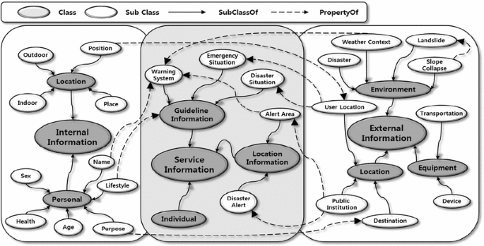
Classes and relations in the integrated hierarchical disaster management ontology

References
Clcoksin, W.F.: Artificial intelligence and the future philosophical transactions. Math. Phys. Eng. Sci. 361(3), 1721–1748 (2003)
Jung, H., Yoo, H., Chung, K., Lee, Y.: Performance analysis of intelligence pain nursing intervention U-health system. J. Korea Contents Assoc. 13(4), 1–7 (2013)
Jung, H., Chung, K.: Discovery of automotive design paradigm using relevance feedback. Pers. Ubiquitous Comput. 18(6), 1363–1372 (2014)
Chung, K.Y.: Recent trends on convergence and ubiquitous computing. Pers. Ubiquitous Comput. 18(6), 1291–1293 (2014)
Song, G.Y., Cheon, Y., Lee, K., Lim, H., Chung, K.Y., Rim, H.C.: Multiple categorizations of products: cognitive modeling of customers through social media data mining. Pers. Ubiquitous Comput. 18(6), 1387–1403 (2014)
Chun, H.W.: Disaster prevention information technology. Electron. Telecommun. Trends, 140, 145–154 (2013)
Ryu, S.-I., Ahn, H.-W.: Improving disaster response system using network—focused on Korea and Japan’s disaster cases. J. Korea Contents Assoc. 7(2), 170–179 (2007)
Barry, A., Nick, F.: Man-Made Disasters. Butterworth-Heinemann, Oxford (1997)
Chae, K.S.: A comparative study on the disaster management system in local government. J. Local Gov. Stud. 8(4), 129–145 (2005)
Seo, T.W., Jung, D.H., Jeong, M.G., Kim, C.S.: Design of cyber disaster management system using IT conversions technology. Korean Soc Internet Inf. 6, 811–815 (2010)
Department of Homeland Security, US. http://www.dhs.gov
Ministry of Government Administration and Home Affairs, Korea. http://www.mospa.go.kr
Central Disaster and Safety Countermeasures Headquarters. http://www.snskorea.go.kr
Kang, S.K., Chung, K.Y., Ryu, J.K., Rim, K.W., Lee, J.H.: Bio-interactive healthcare service system using lifelog based context computing. Wirel. Pers. Commun. 73(2), 341–351 (2013)
Kang, S.K., Chung, K.Y., Lee, J.H.: Real-time tracking and recognition systems for interactive telemedicine health services. Wirel. Pers. Commun. 79(4), 2611–2626 (2014)
Wang, B.R., Park, J.Y., Chung, K.Y., Choi, I.: Influential factors of smart health users according to usage experience and intention to use. Wirel. Pers. Commun. 79(4), 2671–2683 (2014)
Oh, S.Y., Ghose, S., Chung, K., Han, J.S.: Recent trends in convergence based smart healthcare service. Int J. Technol. Health Care 22(3), 303–307 (2014)
Jung, E.Y., Kim, J., Chung, K.Y., Park, D.K.: Mobile healthcare application with EMR interoperability for diabetes patients. Cluster Comput. 17(3), 871–880 (2014)
Chung, K., Boutaba, R., Hariri, S.: Recent trends in digital convergence information system. Wirel. Pers. Commun. 79(4), 2409–2413 (2014)
Oh, S.Y., Ghose, S., Jang, H.J., Chung, K.: Recent trends in mobile communication systems. Int. J. Comput. Virol. hacking 10(2), 67–70 (2014)
Federal Emergency Management Agency. http://www.fema.gov
Cabinet Office Disaster Management, Japan. http://www.bousai.go.jp
Lee, S.H.: International disaster safety wireless network deployment and operational trends. Wkly. Tech. Trends 1520, 5 (2011)
Chang, S.C.: A synchronous cooperative communication for emergency alert broadcast based on cellular systems. J. Broadcast Eng. 19(2), 184–194 (2014)
Skempton, A.W., Hutchinson, J.H.: Stability of natural slopes and embankment foundations. State-of-the art report, Proc. of 7th Int., Conf. SMFE, Mexico. City 2, 291–335 (1948)
Petterson, K.E.: The early history of circular sliding surfaces. J. Géotech. 5, 275–296 (1955)
Fellenius, W.: Calculation of the stability of earth dams. Second congress on large dams, pp. 445\(\sim \)462, 1986
A. W. Bishop, L. Bjerrum, “The Relevance of the Triaxial Test to the Solution of Stability Problems” Proc., ASCE Reserach Conf. on Shear Strength of Cohesive Soils, Boulder, Col., pp. 437–501. 1960
Janbu, N.: Slope Stability Computations in Embankment Dam Engineering, Casagrande Memorial Volume, pp. 47–86. Wiley, New York (1973)
Nash, D., Anderson, M.G., Richards, K.S.: Slope Stability: A Comparative Review of Limit Equilibrium Methods of Stability Analysis, pp. 11–75. Wiley, New York (1987)
Kim, S.H.: Development of the 3D viewer of slope stability analysis for Rockfall and Landslide prevention system, Final Report, Korea Agency for Infrastructure Technology Advancement (2008)
Schilit, B.N., Adams, N., Want, R.: Context-aware computing applications, In Proc. of the workshop on mobile computing system and applications, pp. 85–90, (1994)
Merriam-Webster Inc, : Merriam Webster’s Collegiate Dictionary. Merriam-Webster, Springfield (1997)
Brown, P.J., Bovey, J.D., Chem, X.: Context-aware applications: from the laboratory to the marketplace. IEEE Pers. Commun. 4, 58–64 (1997)
Dey, A.K.: Providing architectural support for building context-aware applications. Ph.D. thesis, Georgia Institute of Technology, (2000)
Gu, T., Pung, T.H. K., Zhang, D.Q.: An ontology-based context model in intelligent environments. In Proc. of communication networks and distributed systems modeling and simulation conference, 2004: 270–275 (2004)
Kim, J.H.: Context-information based item recommendation technique for personalized U-healthcare service. Ph.D. thesis, Inha University, Republic of Korea (2010)
Ryu, J.K.: An ontology driven intelligent healthcare system with wearable sensors. Ph.D. thesis, Inha University, Republic of Korea, (2012)
Kim, S.H., Chung, K.Y.: 3D simulator for stability analysis of finite slope causing plane activity. Multimed Tools Appl. 68(2), 455–463 (2014)
Kim, J.H., Kim, J., Lee, D., Chung, K.Y.: Ontology driven interactive healthcare with wearable sensors. Multimed. Tools Appl. 71(2), 827–841 (2014)
Kim, J.H., Chung, K.Y.: Ontology-based healthcare context information model to implement ubiquitous environment. Multimed. Appl. 71(2), 873–888 (2014)
Acknowledgments
This research was supported by a Grant (14CTAP-C078863-01) from Infrastructure and transportation technology promotion research Program funded by Ministry of Land, Infrastructure and Transport of Korean government.
Author information
Authors and Affiliations
Corresponding author
Rights and permissions
About this article

Cite this article
Jung, H., Chung, K. Ontology-driven slope modeling for disaster management service. Cluster Comput 18, 677–692 (2015). https://doi.org/10.1007/s10586-015-0424-1
Received:
Revised:
Accepted:
Published:
Issue Date:
DOI: https://doi.org/10.1007/s10586-015-0424-1