
Abstract
The archaeological community worldwide now readily recognizes the role and significance of interregional interaction in the development and sustenance of urban societies (e.g., Marcus and Sabloff 2008; Sinclair et al. 2010; Trigger 2003). Over the past two decades, we have carried out a systematic, problem-oriented research program on the Kenyan coast and its hinterland in an effort to understand the ecological and cultural milieu that enabled towns and city-states to develop along the East African coast beginning in the late first millennium CE. Archaeological research complemented with historical sources of the eighteenth and nineteenth centuries shows that different scales of analysis can be used to understand the long-term history of the development of urbanism along this Swahili coast: local, regional, and trans-continental frames of reference each show that Swahili communities were part of numerous networks of interactions. An emerging picture of preindustrial urbanism shows that local, regional, and trans-continental interaction spheres tied coastal towns to the hinterland and to wider Indian Ocean commercial and social networks. Not all of the theorized links between the coastal towns and their local and regional trade and interaction partners will be visible archaeologically. We address the still poorly known elements of preindustrial regional networks of alliance and interaction spheres between urban and rural polities and argue that an integrative approach is necessary to understand the context of coastal urban society.
Résumé
La communauté archéologique mondiale reconnaît maintenant le rôle et l’importance des interactions interrégionales dans le développement et le maintien des communautés urbaines (e.g., Marcus and Sabloff 2008; Sinclair et al. 2010; Trigger 2003). Durant deux décennies, nous avons développé un programme de recherches systématiques traitant de différents problèmes sur la côte et l’intérieur des terres kenyanes dans le but de comprendre les milieux écologiques et culturels qui ont permis les établissements humains, qu’ils s’agissent de villes ou de cités-états, le long de la côte est de l’Afrique à partir du milieu du premier millénaire de notre ère. Les recherches archéologiques ainsi que les sources historiques du dix-huitième et du dix-neuvième siècle montrent qu’une telle analyse visant à comprendre l’histoire à long terme du développement de l’urbanisme le long de la côte swahilie peut être menée à plusieurs niveaux: quel que soit le référentiel choisi, local, régional ou transcontinental, il est possible de voir que les communautés swahilies faisaient parties de réseaux d’interaction à diverses échelles. Le tableau que nous brossons ici révèle que les sphères d’interactions locales, régionales et transcontinentales lient les villes côtières à l’intérieur des terres et au réseau commercial et social de l’Océan indien. Tous les liens entre villes côtières et leurs partenaires commerciaux locaux et régionaux mis en avant dans cette théorie ne sont pas perceptible archéologiquement. Nous prenons en considération ces éléments encore peu connus de notre connaissance des alliances au sein des réseaux préindustriels et des sphères d’interaction entre les communautés rurales et urbaines et nous prétendons qu’une approche créative et intégrative est nécessaire à la compréhension du contexte des sociétés urbaines.
Introduction
One of the central theoretical debates in the later prehistory of eastern and southern Africa concerns the origins of precolonial urbanism and the nature of urban–hinterland relationships (Chami 1998; Fleisher 2010; C. Kusimba 2008; LaViolette and Fleisher 2005; Sinclair 2010; Sinclair and Håkansson 2000). Precolonial urban polities emerged from the eighth to the thirteenth centuries CE. The predominant model of these cities is as centers of elite merchant activity with trade partners at local, regional, and, via Indian Ocean maritime trade, international scales (Mitchell 2005; Pearson 2003). The wealth accumulated by African merchants, who exchanged African products for foreign trade goods, formed the basis of complex urban polities, chiefdoms, and states along the coast and in southern Zambezia (Guillian 1856: 266; Horton 1996; Manyanga et al. 2010; Middleton 2004; Pikirayi 2001; Pwiti 2005).
By the nineteenth century, these city-states had diverse and well-defined social hierarchies that incorporated social and economic elites (local and immigrant), commoners, and enslaved persons (Allen 1993; Horton and Middleton 2000; Kusimba 2003; Middleton 1992, 2004; Pouwels 2000; Sheriff 1987, 2010). The elite managed and financed a complex and extensive interregional trade network (Garlake 1973: 172). They also patronized full- and part-time craft specialists, including ironworkers, coral miners, mangrove cutters, weavers, and sailors. They often monopolized ownership of the most productive land, which they then leased to commoners, newcomers, and enslaved persons (Kusimba 1999b; Prins 1961; Romero 1997). Finally, they financed and sponsored long-distance trading expeditions to the African interior to procure ivory, leather, rock crystal, beeswax, rhinoceros horn, and other products for export (Wakefield 1870).
Mabogunje (1962:3–4) first pointed out in his classic study of Yoruba urbanism that cities do not exist on their own but are tied to their hinterlands. He demonstrated that Yoruba cities performed specialized functions in the context of a largely agricultural and undifferentiated hinterland. Nevertheless, cities are often of markedly different character from their hinterlands, including greater ethnic diversity, a higher degree of social complexity and status differentiation, and more diverse economic and subsistence activities, contributing to their “cosmopolitan” character (LaViolette 2008; Marcus and Sabloff 2008; Sinclair et al. 2010; Storey 2006; Trigger 2003). Cities have almost always exerted economic, social, or ideological power with regard to their hinterlands, yet this relationship also faced certain constraints in productivity, communication, and transport that limited city–hinterland interactions. These constraints remained remarkably consistent across the ancient world (see also Bronson 1977; Junker 1999; Storey 1992:119).
In spite of basic shared constraints on ancient urbanism, there is in fact great variation in archaeologists’ approaches to understanding the origin of ancient cities (Sinclair 2010). Usually, the birth of a city emerges out of changes in settlement patterning and landscape within a particular region. Along the Swahili coast, and in Africa in general, there has been a greater focus on the towns themselves because of logistical difficulties, a paucity of researchers, and an external orientation among many colonial and mid-twentieth-century scholars in which Indian Ocean trade and its signatures were privileged (Killick 2009).
Our article will examine the Swahili port city of Mtwapa in terms of three scales of interaction that have been important to urbanization: first, the relationship between Mtwapa and the fishing villages along the mouth of Mtwapa Creek; second, Mtwapa’s trade partners inland from the coast in the Tsavo region; and third, interactions with international trading partners via Indian Ocean networks. At each of these three scales, material evidence connects the urban center of Mtwapa with economic and social interactions that give us clues to the town’s origin. We agree that future studies of Swahili towns must consider the unique historical trajectory of city-states and their hinterlands, and that different models likely explain urbanization in different parts of the coast (Fleisher 2010). However, it is increasingly clear, based on both qualitative and quantitative distinctions in urban settings, that inequality in access to crucial coastal resources, such as human labor, arable land, fishing areas, and mangrove forests, were important factors underlining the emergence of Swahili cities (Kusimba and Kusimba 2009; Kusimba and Oka 2009). As Indian Ocean trade networks overlay these local inequalities, regional and international trade goods were incorporated into elite-controlled social and economic networks. These three scales do not have a necessary chronological relationship, and each of them could be paramount in any particular region at any particular time. The question of the relative importance and the nature of interactions at these three scales is an empirical one.
Scale One: Mtwapa and the Villages along Mtwapa Creek
The first scale of analysis of a Swahili town that we will consider is that of a large town and the smaller communities, often villages, in its immediate hinterland. Large towns were often located at the mouths of rivers or near estuaries, inlets, and offshore islands (Freeman-Grenville 1958; Horton 1996; Wilson 1980; Fig. 1). Within the hinterlands of these large urban areas were smaller rural village communities that were linked to the large settlements. The site of Mtwapa is an excellent example for evaluating such connections and interactions (Mitchell 2005).

The archaeological landscape of the Kenyan coast and its hinterland (J. Seagard)
Located on the Mtwapa Creek some 15 km north of Mombasa, Kenya, the port town of Mtwapa originally covered about 9 ha out of which about four still contain standing architecture, including one main congregation mosque, 64 houses, some 20 mounds, and 13 wells (Fig. 2). At its height, Mtwapa’s estimated population reached 5,000 (Kusimba 1993). As a port, Mtwapa’s role in regional and overseas trade is evident in the nature and distribution of artifacts recovered in excavations (Dussubieux and Kusimba 2009; Dussubieux et al. 2008; Kusimba 1999a; Oka 2008). The town’s location at a deep natural harbor with excellent careening facilities placed it in a most favorable position to engage in interregional social and economic networks.

Mtwapa settlement (E. Wert)
Mtwapa was abandoned after ca. CE 1750 following the effects of the Little Ice Age and the decline in international maritime trade. Our research, carried out over ten seasons since 1986, has established Mtwapa as an important site in Swahili history. The site has been inhabited for nearly 4,000 years (Table 1). Mtwapa’s location on a navigable creek offered advantages of direct interaction between coastal and hinterland trade and, where appropriate, direct trade between foreign merchants and hinterland peoples (Kusimba 1999b). Hinterland peoples were also likely to exercise some power in the affairs of the town since they could circumvent other towns’ rules, which tended to restrict non-elite access to foreign traders and merchants (Nicholls 1971; Willis 1993). In this sense, Mtwapa’s location could have served to reduce local elites’ dominance as middlemen and make it a place where trader-friendly rules were likely to be exercised (e.g., Gray 1957: 61; Sheriff 1971: 136). Minimalist monopoly over access to foreign and hinterland traders provided opportunities to forge regional and interregional networks that were unavailable to hinterland traders associated with more isolated island towns, such as Mombasa and Lamu, and regions such as Pemba Island, among others, where local elites monopolized access and trade relationships with foreign merchants and served as primary middlemen.
The stone house has had a long history in Swahili culture as a symbol of elite power and social distance (Allen 1976; Donley-Reid 1984, 1990; Ghaidan 1976). At Mtwapa, three clusters of complex houses were discerned. All complex structures were well fortified with a perimeter wall enclosure. Compound houses were built east of the town. Single houses were mostly found south and southwest of the main congregation mosque.
A perimeter wall surrounded the town’s core. However, as the town’s population increased, the community built outside the wall. At its height, Mtwapa had two distinct resident communities—one residing within its walls and the other outside. Both within the town wall and outside it, differences in house size, elaboration, and construction materials show a community characterized by a broad range of class, wealth, and likely social status differences. Thus, like other contemporary coastal settlements, Mtwapa’s resident population was economically diverse.
Neighborhoods differentiated by vocation and social class are clearly visible in the type, quality, and style of construction. For example, access to critical wealth-creating resources such as fertile farmland, fishing grounds, mangrove forests, and exotic trade networks became increasingly restricted. Differences in wealth were displayed in the type of material and skill used in house construction and in house size, which implied longer use-life and permanence. For example, the door frames of multi-room stone houses were of porites coral. All multi-room houses had flat coral tile roofs and all included toilets and/or bathrooms and wells. All multi-room houses had comparatively large courtyards. In contrast, single-room stone houses had no wells, and the quality of their finishing was less well executed when compared with complex structures. Excavations at Locality 5, a single-unit stone house, showed that it originally had a mud-on-wooden frame but was significantly improved relative to household prosperity. Mud was used as mortar in some houses instead of lime. Many single-unit houses appear to have had grass or coconut thatch roofs. None had a coral ceiling.
The ceramic assemblage from Mtwapa town shows the evolution of class distinctions and changes in taste and habit of this society. First, 94 % of all the ceramics were locally produced, but there was a transition from small eating bowls during the later period to shallow dishes, cooking pots, and jars. The diversity of style and form may also be indicative of transformations in tastes, eating habits, and even family sizes (Kusimba 1999b; see also Fleisher and Wynne-Jones 2011; Horton 1996). Even when nonlocal wares are considered, however, there was great variation from one excavated locality to the next in terms of the types of nonlocal ceramics represented and their proportions in assemblages (Oka 2008). Nonlocal pottery and glassware were consistently associated with only a few localities at complex and compound houses almost exclusively; moreover, these associations appeared in the earliest levels of the excavations dated to the fourteenth century CE and remained consistent throughout the sequence until the upper levels dated to the eighteenth century CE. Rahul Oka’s (2008) study of trade ceramics, including Chinese and Islamic pottery and porcelain, at Mtwapa asserts great disparities in the distribution of power and wealth within the town. The wealthy, including both political and economic elites, resided in better-constructed and secured quarters and enjoyed unequal access to basic resources like water. They also had exclusive rights to being buried near the town’s main congregational mosque, the Friday Mosque.
Around Mtwapa—The Village of Kizingitini
Full-coverage survey beginning at the mouth of Mtwapa Creek and extending along both sides about 20 km recovered a total of 21 Late Iron Age sites identified on the basis of pottery (Soper 1967a, b). The sites were remains of what appeared to be a large settlement that was located along the creek. The dispersed villages and homesteads of this nature help elucidate the nature of stone town–country town relationships (Allen 1993; Fleisher 2010; Pawlowicz 2012). Surveys and excavations by Henry Mutoro in the 1980s in the immediate hinterland of Mombasa and Mtwapa (Mutoro 1987), and by George Abungu in the 1990s at Wenje along the Tana River, in the hinterland of Ungwana (Abungu 1990), suggested trade connections that linked coastal communities to their hinterland neighbors (Abungu 1998; Mutoro 1998; Mutoro and Abungu 1993). The work of Jonathan Walz in the Usambara region along the Pangani River (Walz 2010), ongoing research by Matthew Pawlowicz (2012) in the Mikindani area of the southern Tanzanian coast, and surveys by Richard Helm, which build on earlier work by Mutoro, have shown that settlements in the coastal hinterland were located in resource-rich locales close to fresh water rivers, defensible hillsides, and fertile soils (Helm et al. 2012). In fact, our survey indicates significant differences in settlement patterns and ceramic technology; this in turn shows that a distinctive village lifeway persisted in the shadow of the stone town. Like Mutoro’s and Abungu’s work, our survey yielded no significant evidence of social stratification, which is often associated with large coastal port towns such as Mtwapa, Ungwana, or Takwa (Abungu 1990; Kusimba 1993; Mutoro 1979, 1987; Wilson 1980). Instead, the recovered material remains, including postholes and pottery dominated by cooking pots and jars, pointed to a more or less agrarian and fisher folk lifestyle (e.g., Haaland 2007). Salt seepage may have contributed to the lack of faunal remains. Surface and excavated materials recovered at these sites included abundant pottery, all of it local. Seven radiocarbon dates confirmed that the settlement is contemporaneous to Mtwapa and Jumba la Mtwana (Table 2).
Decorative motifs on pottery found at three out of six LIA sites along Mtwapa Creek conform to the Tana ware nomenclature (Fleisher and Wynne-Jones 2011). The majority of vessels were low-fired water jars, water pots, and cooking pots. Although the Creek and Mtwapa town communities were contemporaneous and almost certainly interacted on a regular basis, the pottery excavated at the Creek sites was distinguishable from Mtwapa pottery by decorative motifs, form, and style. The Creek pottery exhibited a much smaller repertoire of forms and styles, and its finishing and skill in firing was qualitatively inferior. We attribute these differences not to ethnicity but rather to differences in the social contexts of manufacture. The diverse Mtwapa pottery’s relative sophistication suggests part- to full-time specialization; by contrast, Creek pottery suggests household manufacture primarily for home use.
The Mtwapa-Kizingitini pattern can shed light on the process of urbanization that differentiated the landscape of Mtwapa Creek as the stone town emerged. Stone towns and their hinterlands have always been connected; for example, Allen (1993) proposed, based on ethnographic observations in the Lamu archipelago, that townspeople shifted residence to their countryside farms for planting or harvesting. Initially at least, the interaction of these towns and their local hamlets would have been based on kin groups and alliances. Nicholls (1971), Herlehy (1984), and Willis (1993) describe alliances, patron–client relationships, and fictive kinship that fostered exchanges of goods and labor between small and large settlements. However, it seems that over time the urbanites’ broader networks increasingly differentiated them from their rural kin. These differences manifested themselves in terms of taste, including clothing, aesthetics, religion, mortuary practices, and diet.
Scale Two: The Interior and the Coast Interaction Spheres
The second scale of analysis is a regional one; it could encompass the relationships of towns and settlements with each other along the coast, and it could also encompass relationships with that most economically crucial trading partner—the East African interior (e.g., Abungu 1990, 1998; Mutoro 1987, 1998; Walz 2010).
We initiated fieldwork in the Tsavo region 150 km east of the Kenyan coast in 1997. Tsavo was an ethnically and economically diverse area well into the early twentieth century. The historic peoples of the Tsavo mosaic include the Waata, understood historically to be peripatetic foragers (Report of the Kenya Land Commission 1933: 309); the Taita, agriculturalists of the terraced uplands of the Taita Hills (Report of the Kenya Land Commission 1933: 319); the Akamba, agropastoralists; the Wambisha, forager/herders (Kimambo 1970: 90; Lindbloom 1919); and the Oromo, pastoralists (Gregory 1968: 386).
Historically, Tsavo groups pursued different economic strategies in different environs of the ecological mosaic. They maintained their identities in spite of a high degree of trade and the movement of people across community boundaries, which has been confirmed through archaeology, ethnohistory, and linguistics (Ehret and Nurse 1981; Prins 1961). Taita and Oromo pastoralist groups were organized into patrilineal corporate groups. Although these societies lacked ranking, significant authority was held by elder males who sought to accumulate cattle and land and to control their distribution (Kumsa 1997). Consequently, intergroup conflict over wealth-building resources, such as cattle, coexisted with alliances for the exchange of goods, information, and ritual power (Bravman 1998; Kusimba and Kusimba 2005; Merritt 1975). Some forms of technical and practical knowledge, such as hunting techniques, poison making, and animal tracking, were so prized that blood brotherhoods and secret societies controlled the spread of this sacred information: Critical oral information for a better understanding of how alliance-building and information exchange occurred (Von Hohnel 1968: 267).
Macropatterns or Site Clusters in Tsavo
During our surveys, we located 250 new archaeological sites. Our survey identified six macropatterns or regional clusters (Table 3). We describe the basic characteristics of each macropattern below.
-
1.
Mortuary Sites (Cairns and Skull Sites)
Graves, cemeteries, cairns, and skull interment sites occur widely in the Tsavo region (Kusimba et al. 2005; Lugard 1959: 261; Soper 1965: 4, 1966, 1976; Thorbahn 1979). Thorbahn (1979: 210–11) attributes burial cairns to Oromo pastoralists, who inhabited Tsavo's arid plains until they were designated a national park in 1948 (cf. Gregory 1968: 325). Local Taita informants have variously attributed cairns to the Wambisha and Oromo (Soper 1965). Lone graves marked by stones along known trade routes are often attributed to Arab, Swahili, and other caravan traders and porters. We assume that slave captives who succumbed along the way—victims of thirst, disease, and a host of other agents of death—were rarely buried. Skull sites in the region are attributed to the Taita.
Our team discovered eight cranial display niche sites with skull remains. Taita interment sites were located close to villages in outlying rock shelters, rock crevices, and shallow coves. The shelters for the ancestors were placed in dry and quiet places that were in close proximity to inhabited areas so that they could be maintained and protected from predators as well as witches. Ancestors were regularly propitiated in order for them to ward off potential calamities and crises such as drought, disease, childlessness, and witchcraft. At one site in Saghala, a nearby large rock was used as an altar for preparing gifts to present to ancestors. Large partially broken pots and gourds found at interment sites provided evidence for the ceremonial feasting that occurred at these sites.
-
2.
Open-Air Hunter–Gatherer Settlements
As in other regions in Africa, open-air hunter–gatherer settlements were difficult to identify (Kessy 2013). However, the Tsavo landscape was marked by extensive grinding hollows that could be found in almost all prominent low inselbergs and on rocks along seasonal springs and rivers. These grinding hollows ranged from groups numbering a handful to several hundred. Many represented food processing activities such as grinding cereals, roots, and skin tanning; others bore evidence of recreational use and were likely precursors of the popular African bao game. Still others may have been used as symbolic markers (David 1998). Hobley (1895) wrote that Tsavo's prominent inselbergs were used historically as regional market centers, attracting peoples from the wider region. Regional trade and exchange in bush and agricultural products are known to have occurred at inselbergs such as the prominent Mudanda Rock in Tsavo East and the Rhino Valley Rock in Tsavo West (both almost 1 km long). At Mudanda, large quantities of chert and quartz stone tools were found, although construction of a waterhole had distorted these finds. The Rhino Valley Rock area contained over 300 grinding hollows of different sizes and shapes, showing the diversity of economic activities carried out at this locality. Future excavations will target these areas to test the hypothesis of their role as centers for interregional trade and exchange.
-
3.
Iron Working Sites
Iron bloom and artifacts were among the principal trade items that were exchanged amongst precolonial African peoples (Kessy 2013). Field and laboratory investigations into the history of metallurgical technology in East Africa have demonstrated that early iron metallurgy in precolonial coastal East Africa was sophisticated enough to include the use of crucible steel (C. Kusimba 1993, 1999a; C. Kusimba and Killick 2003). Coastal iron makers are believed to have been capable of satisfying regional and interregional demands for iron (Emery 1833; Gray 1957: 61; C. Kusimba 1993). Furthermore, African iron may have been exported to places as distant as South and West Asia, perhaps as bloom or even as finished artifacts (C. Kusimba 1993; C. Kusimba and Killick 2003). Hence, the rise of iron technology and trade played a key role in the development of social complexity along the coasts of Somalia, Kenya, Tanzania, and Mozambique (C. Kusimba 1999a, 1999b). In later times, when knowledge of iron production was widespread, hinterland areas of abundant ores and wood charcoal could sustain major ironworking industrial complexes. One such region is Kasigau, where magnetite ore outcrops abound near the Rukanga and Kirongwe villages (Kusimba et al. 2005). Here, our surveys recovered two large iron-working sites, one at Rukanga and the other at Kirongwe.
The sites cover large areas of nearly 1 ha and appear to have been centers of intensive iron production for at least 800 years. We recovered a stratigraphic sequence of nine radiocarbon dates dating back to 1150 ± 70 BP at K1 (Kusimba et al. 2005). Furnace technology was primarily of bowl furnaces. Both iron smelting and smithing were undertaken in Rukanga and Kirongwe. Our survey and subsequent excavations of smelting sites at Kirongwe recovered five smelting furnaces at K7. The recovery of a smithy at K1 revealed multiple uses of a rockshelter for residence and craft activities, including smithing. Excavated artifacts at rockshelters K1 and K2, including a stone anvil, a large volume of tuyere fragments, slag, and both finished and unfinished tools attest to the complexity of iron production in Tsavo. Significant volumes of slag and slag-wetted tuyeres found in levels 7 through 11 demonstrate that the most intensive iron smelting occurred during the deposition of these levels, dating from 840 ± 70 to 1150 ± 70 years BP. Overlying younger levels, dating to the last 500 years or so when calibration is taken into account, have much more abundant stone tools and could indicate reoccupation of the site by a group possessing an expedient technology.
Iron was an important craft and exchange item that is also preserved in the archaeological record. Historical sources indicate it was a vital part of both subsistence economies and luxury trade, and its role in facilitating the clearing of cropland is well known (Huffman 1982, 1989; Oliver and Fagan 1975). However, in the Tsavo case, we think iron was much more important for enabling humans to kill elephants, whose ivory was in high demand in Asia and Europe. The technical quality of iron made in Tsavo was impressive. The recovered arrowheads and spear points have excellent cutting and penetrating qualities capable of serving primarily as elephant-killing weapons. We believe iron-working industries at the Kasigau sites of Rukanga and Kirongwe serviced a clientele of complex professional hunters, who made a living through the hunting of elephants and provisioning ivory to coastal merchants, as well as to local farmers.
-
4.
Rockshelter and Cave Sites
Archaeological surveys, ethnohistorical evidence, and ethnoarchaeological research suggest that there may well be hundreds of rockshelter and cave sites in the Tsavo region. Our surveys have thus far found more than 40 rockshelters and caves in the Bungule and Kirongwe areas (Fig. 3). Before the introduction of domesticated crops, the rockshelters served as seasonal residential areas and ephemeral campsites for hunter–gatherer dwellers, judging from our radiocarbon dates at Bungule 9, which go back to Late Pleistocene/Early Holocene times. Gradually, however, some of the shelters became used for highly specialized activities. Some rockshelters included grinding hollows and dry-stone architecture. According to the elders of Kasigau, some served as ancestral shrines or as armories for the community's weaponry. Many were associated with rainmaking and witchcraft or served as stockades for hiding during times of stress and warfare; later, many became areas for penning and pen-feeding livestock. Bungule 20, in particular, is an example of a rockshelter modified with obvious defensive intent (Fig. 4). Informants stressed the role of these hideouts in conflicts with cattle thieves and slave traders (Kusimba 2004).
Fig. 3 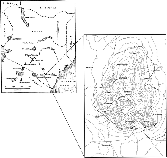
Kasigau archaeological sites (J. Seagard)
Fig. 4 
Bungule 20, a massive fortified Rockshelter in Kasigau, Tsavo region
-
5.
Kasigau Terraced Settlements and Fields
Although our informants indicated that Taita practiced irrigation farming, archaeological evidence has thus far been elusive (Soper 1965). Our surveys revealed that the entire Kasigau hillslope contained a complex maze of terraced fields, as did Ngulia Hills. These terraced fields ran across ridges that were sculpted by seasonal springs, streams, and small rivers. Each ridge contained extended family houses, and their fields where they sowed sorghum, millet, beans, pumpkins, and, later, maize. Local village elders maintain that each lineage occupied several terraces adjacent to each other. The elders interviewed emphasized that the system of land tenure recognized individual rights to terraced land. Abandoned and/or poorly maintained terraces endangered neighboring terraces and thus would have been leased to individuals or families in need of land. In later years, these terraces suffered neglect as people relocated.
-
6.
Fugitive Stockade Settlements
From the seventeenth century, many rockshelters and caves were fortified in response to declining regional security (Kusimba 2004, 2006). Of the 30 shelters we discovered, 18 had some evidence of fortification. Based on our excavations of Bungule 20 and 28, which yielded radiocarbon dates on the foundations of dry stone walls, fortification may have begun as early as 400 years ago (Table 4). The enclosures had large dry stonewall faces supported by vertical wooden frames. Most sites had two sections: one for people and the other for livestock. Most had an entrance and exit, and, in these cases, both access ways were protected by wooden partitions that ran parallel to the wall. For example, Bungule 20 was a formidable structure measuring 66 m2 with a ceiling height ranging between 0.30 and 1.75 m.
Table 4 Kasigau radiocarbon dates As in other enclosures, a partitioned area was constructed to separate people from their animals. Surface finds included an almost intact bed, a hearth, and pottery sherds. These appear to be modern surface deposits not associated with the primary in situ archaeological deposits. Three radiocarbon samples obtained from the vines and wood holding the dry stone wall had uncalibrated radiocarbon ages of 207 ± 40, 290 ± 70, and 300 ± 70 BP, placing the calibrated date of construction of the dry wall some time in the last 400 years at two standard deviations.
Excavations further revealed a detailed process of dry stone construction. This involved digging a foundation and erecting a wooden frame with termite-resistant hardwoods tied with twine. Large rocks would then be piled along the wooden frame from the base foundation, and smaller blocks would be fitted into any open spaces remaining. Finally, clay soil from the termite hills was applied as a plaster seal to ward off insects and weatherproof the wall. The resulting structure was strong, impenetrable, and aesthetically beautiful. The recent date of rampart construction and paucity of artifacts corroborate informants' oral histories, indicating that Bungule 20 and other similar rockshelters were fortifications and refugia against slave hunters and others feared by Kasigau people.


The Chronology of Tsavo and Kasigau
Based on the radiocarbon dates now available from Tsavo, we can reconstruct the chronological history of the area into five major periods (Table 5).
Period 1: Early–Late Holocene (cal. 10000–3000 BCE)
Although we documented Early and Middle Stone Age sites, our focus is on the Holocene period. The lower levels of Bungule 9, a rockshelter with wild faunal remains and quartz stone tools, represent the earliest dated evidence of human activity during the Holocene in the Tsavo region. There are no data available to support the existence of interactions between Tsavo and the coast at this time, although some obsidian stone tools indicate person-to-person trade. The source of this obsidian has not been established. The lithic artifacts recovered from Bungule 9 demonstrate the use of bipolar flaking techniques, Levalloisian core reduction, and the production of small flakes using these methods. While Levalloisian cores are generally associated with the Middle Stone Age, it is not unusual to find them used to reduce quartz raw materials at Later Stone Age sites such as Lukenya Hill (S. Kusimba 2003).
Period 2: Pastoral Neolithic–Early Iron Working (cal. 3000–500 BCE)
The beginning of pastoral food production in Kenya has been dated to at least 4,000 years BP. Presently, most Pastoral Neolithic sites known in East Africa date to between 3,300 and 1,300 years BP and occur above 1,500 m (Ambrose 1998; Bower 1997; Gifford-Gonzalez 2000). Some scholars have interpreted the early distribution of domesticated animals as being restricted to areas free of tsetse flies (Gifford-Gonzalez 2000) or limited by extreme aridity (Ambrose 1998). However, the traditionally recognized routes along which incipient domesticates spread through sub-Saharan Africa could need revision (Marshall 2000; Stock and Gifford-Gonzalez 2013).
Molars likely to be of Bos taurus, a native sub-Saharan cattle species, were recovered by David Wright (2005) at the riverine sites of Kahinju at 3,870 ± 330 years BP (UIC1068) and Kathuva at 3,450 ± 290 years BP (UIC921). At B9, domesticated cattle are present in levels dating to this period, as are beads, some of marine shell demonstrating contact with the coast. At Muasya Rockshelter, ovicaprids were recovered in the earliest levels of the site. These data show that domesticated animals appear in Tsavo as early as they do in the Central Rift Valley.
Period 3: Early Iron Working (cal. 500 BCE–CE 1000)
During the Early Iron Working period, intensive iron production was practiced in Tsavo, where iron smelting, forging, and the presence of iron artifacts were indicated at sites Kirongwe 1–7. The K7 smelting site was located in proximity to an iron-rich ore outcrop. Subsequent investigations uncovered six bowl furnaces and associated tuyeres. The volume of slag is comparable with the scale of smelting industries undertaken at other East African sites, including Limbo and Galu (Chami 1994; C. Kusimba 1993, C. Kusimba and Killick 2003; Mapunda 2003; Schmidt 1995). It is fully reasonable to hypothesize that Kirongwe iron was traded on a regional scale.
Period 4: Late Iron Working (cal. CE 1000–1500)
During the Late Iron Working period, the regional economic system flourished. A diversity of site types are known from this period in Kasigau, Ngulia Hills and Rhino Valley, Konu Moju and Dakota plains, and other areas. Habitation sites dating to this period include rockshelters, caves, villages, and homesteads, and pastoral villages and camps. The artifacts and features noteworthy at these sites include dry stonework around rockshelter livestock pens; terraced farming; trade goods like ivory, ostrich eggshell, and marine and glass beads; and the continued use of stone tools for specialized tasks by many groups, especially foragers.
Period 5: Colonial (cal. CE 1500–1900)
During the colonial period, many settlements in the plains and hill aprons were abandoned. Our surveys show a shifting preference for hilltops, hillsides, and generally hard-to-reach places as favorable areas for settlement. Interestingly, most of the sites were fortified at a time when the cult of ancestor veneration emerged amongst the Taita (Bravman 1998). We hypothesize that the tradition of disinterring ancestor skulls might have developed in response to decreasing size of cultivable land as people became more tethered to the hills. The low volume of artifacts recovered at Period 5 sites points to a decline in interregional trade and craft specialization. On Kasigau, this period was associated with important evidence of disruption of these mosaics—hilltop refuge sites, often heavily fortified with dry stonework. These fortified rockshelters are a potent reminder of the costs of interactions during the historic period, when the slave and ivory trade became a focus of the caravans (Nicholls 1971: 76; Sheriff 1971: 101).
The Significance of Mosaics
Ecological diversity encouraged internal trade and exchange amongst Tsavo's inhabitants. Affinal bonds of friendships, usually referred to as blood brotherhoods and/or sisterhoods, were established among trading partners to enable trade and safe passage in what would have otherwise been hostile territory (Herlehy 1984). The trade boom in ivory, iron, salt, cloth, ornaments, and foodstuffs created local and regional entrepreneurs among Akamba, Taita, Waata, Giriama, Swahili, and other communities (Kimambo 1970; Middleton 2004; Muriuki 1974; Prins 1961:99; Robertson 1997; Unomah and Webster 1976: 277). Thus, trade and other opportunities spawned subsidiary craft specialization enterprises. These included iron smelting and blacksmithing to provision hunters, herders, miners, farmers, and warriors, poison making to provision hunters and warriors, basket making to provision caravan traders and porters, and potters and grindstone carvers to provision farmers, hunter-gatherers, and herders. At the height of this regional economy, intensification was a response to regional and extra-regional demands.
Between CE 1400 and 1600, Kasigau was a major distribution center for local and regional trade, as well as lodging and camping ground for interior and coastal long-distance trade (Wakefield 1870). Trade items exchanged at Kasigau included beads, cloth, textiles, honey and beeswax, fresh fruits, milk, ivory, rhinoceros horns, and animal skins among others. The introduction of coastal crops such as coconuts, tamarind, oranges, lemons, and mangoes in Kasigau was in part due to the trade boom and the high demand for these products by coastal traders. Everyone in the Tsavo region and beyond appears to have been involved in regional trade (Smee and Hardy 1811:176). The presence of refuge sites (Kusimba 2006) attests to the widespread insecurity and collapse engendered by the colonization of the East African coast and the rise of the slave trade.
Scale Three: The Trans-continental Scale
The final, trans-continental scale of interaction brings us back to the original lure of the Swahili for the archaeological founders of the field, whose explanatory framework of external origins has been soundly rejected but whose examinations of nonlocal pottery and other imported artifacts still provide benchmarks of chronology for many Swahili sites. Apart from conveying the basic spatial differences between elites and non-elite groups within cities, the type and volume of prestige goods also provide information on differential tastes, preferences, and networks within elite groups themselves and the changing fortunes of the different elite localities within a trading center (Junker 1999; Kusimba 1999b). The Islamic Era in the Indian Ocean (CE 700–1750) was characterized by a prestige-goods network that linked elites from East Africa, Southwest, South, and Southeast Asia, leading to overlapping tastes and preferences for luxury consumables, commodities, and gifts (Sheriff 2010). Since the early fifteenth century CE, Chinese blue-on-white porcelains were the most desired prestige ceramics in the Western Indian Ocean. They were also imitated across the Indian Ocean, especially in Southeast Asia (Vietnam and Thailand) and Southwest Asia (Persia, Syria, and Turkey) (Middleton 2004).
At Mtwapa, an analysis of trade ceramics, including Chinese blue-on-white, Chinese celadon, and Chinese white porcelains, shows that in its diverse urban society foreign ceramics were highly restricted (Oka 2008). Before CE 1600, localities 4, 5, and 6 showed similarities in the distribution of all trade ceramics, especially glazed wares. However, this trend reversed completely in the post-CE 1600 period. A majority of the trade ceramics at Mtwapa were relegated to one area, Area 4, located within the main Friday Mosque complex. This was the main gathering zone where the city’s elites would gather to display their status through giving alms to poor and public feasting. The large collection of trade ceramics contrasts with finds in residential quarters, which had comparatively fewer trade ceramics (Fleisher and LaViolette 2007). After CE 1600, the prestige goods received by elites through trade were not kept for display in their homes as before, but increasingly used for public feasting and gift giving at the Friday Mosque. The resultant attrition of wealth was compounded by the decline of local craft production (e.g., iron, steel, cloth).
Given that ceramics were extremely rare even in Mtwapa’s urban context, we can hardly expect them to provide a good signature of the extent of regional and trans-continental trade across scales. However, the Tsavo regional landscape provides much evidence for trans-oceanic interactions in the form of a domesticated landscape (Greenway 1944: 115–116; Terrell et al. 2003) consisting of abandoned mango, orange, lemon, and tamarind orchards. These South and Southeast Asian domesticates provide the best evidence yet of East Africa’s deep-time interactions with Asia. Yet, this landscape speaks only to one segment of the Tsavo mosaic. To address the entire mosaic one must turn to a little known artifact—the bead. Beads are an appropriate means for reading trans-continental networks that often do not leave abundant archaeological traces (Van der Sleen 1967: 76–91; Wynne-Jones 2010). Beads, unlike pottery, are portable, durable, visible, and highly amenable to the wearer’s manipulation and self-expression. From a trader's standpoint, beads symbolized an investment opportunity unlike any other in human history. Beads reached the global market, from the poorest of the poor to the wealthiest socialites of the time. Compared with other crafts such as ceramics, porcelain, and jewelry, the returns for beads were much larger. Due to their small size, large numbers of beads—literally in the millions—would have been exported. One shipment of beads of different colors and sizes would have fetched enough profits to last a lifetime. Beads thus represent a kind of intensification of trade strategy. One could also argue that the small size and relatively small value of beads would encourage them to be widely traded beyond the Swahili coast once they arrived there, as part of larger and more diverse commodity flows (Fig. 5). Indeed, one of the most striking patterns that emerged from the Tsavo surveys was that glass beads were found at every site we excavated, while other coastal artifacts such as pottery were much rarer.

Diversity of beads from Mtwapa (E. Wert)
By the first century CE, Africa's trade relationships with Eurasia began to be controlled increasingly by growing state societies and significantly contributed to bi-directional biological and technological transfers (Mitchell 2005; Oka and Kusimba 2008; Pearson 2003). Improvements in shipping technology and the introduction of the camel made it possible to trade across the Indian Ocean with East Africa, and across the Sahara with West Africa. Gold, salt, ivory, hides, and spices were typical commodities in this commerce between north and south. Nevertheless, beads were part of this interaction, and wherever they occur, they bear witness to the connections that no other archaeological artifacts can show due to their beauty, universal appeal, affordability, and preservation.
Despite the ubiquity of archaeological glass in Africa, this class of trade artifacts remains one of the least studied on the continent. Compared with other regions, fewer chemical and analytical studies have been carried out on African archaeological glass (but see Davison 1972; Wood 2000, 2012). Recent studies of chemical analysis with laser ablation–inductively coupled plasma–mass spectrometry (LA-ICP-MS) of glass beads from South Africa, Botswana, and Madagascar have provided a better definition of the glass groups (Popelka et al. 2003; Robertshaw et al. 2003) and reported, for the first time, a possible glass-manufacturing site in Africa, dating to around the tenth century CE (Lankton and Rehren 2006), contradicting a long-held view that preindustrial Africans did not produce glass in the early period.
Beads from three different archaeological sites in Kenya were investigated: the urban coastal site of Mtwapa, Bungule, and Muasya Rockshelter in Tsavo. A total of 45 beads from Mtwapa were analyzed, 63 from Bungule, and 26 from Muasya Rockshelter. They were drawn and monochromatic, red, turquoise, and green and had variable shapes. The beads from Mtwapa appear to match quite well the definition of a type called “Indo-Pacific Monochrome Drawn Beads” or IPMDB (Francis 1990). These beads are part of the “Trade Wind Bead” group (Van Der Sleen 1967) that also includes wound beads. These IPMDB have been identified from Africa to Japan and are known to have been manufactured in different places in South and Southeast Asia over a two-millennium-long period.
The beads from Bungule had a more diverse typology compared with those of Mtwapa, even though most Bungule beads were made using the drawn technique. Drawn beads can have a very small diameter (2–3 mm) and are barrel- or annular-shaped. These beads were white (12), blue (10, from turquoise blue to dark blue), dark (10), pink (8), greenish (2), yellow (1), and red (1). All were opaque except for a dark blue one that was translucent. The color, size, and shape of the beads from Bungule were very different from those found at Mtwapa. At Muasya Rock shelter, only barrel-shaped beads in blue (13), white (10), opaque red (2), and opaque red over a greenish core (1) were found. In Table 6, we describe the distribution of the glass compositions by site. All glass beads from Mtwapa belong to the m-Na-Al 2 glass type and are likely to be imports from South Asia (Dussubieux et al. 2008). Muasya Rock shelter had only three glass beads from South Asia compared with 23 of European origin. Like Muasya, Bungule had more European than South Asian glass beads. The diversity of European compositions exhibited at Bungule was wider compared with Muasya. The presence of European compositions at Bungule and Muasya is likely because these sites were occupied over longer period (Table 6).
Based on the analytical results carried out by one of us, LD, using the LA-ICP-MS instrumentation, we concluded that the glass-bead trade in East Africa belonged to two different networks: the Afrasian Trade Network (ATN) and the Eurafrasian Trade Network (ETN). The ATN involved the Indian Ocean, Middle East, and South Asia while the ETN appears to be primarily European commerce in the Indian Ocean. Mtwapa was linked to the ATN, while Muasya and Bungule were part of the ETN (Dussubieux et al. 2008).
Conclusions
Swahili urbanism, being a product of trade networks on local, regional, and international levels, requires a multi-scale perspective. Through this approach, we were able to gain an understanding and appreciation of contributions of all segments of society, including commoners, peasants, the underclass, and slaves, groups often left out of early historical accounts of Swahili urbanism. The archaeological findings from the three interactive regions have provided a long-term perspective on change, documenting the origins of herding, pastoralism, and agriculture, the rise of urbanism, and other transformational social changes, including the decline, collapse, and colonization of the region. Data from many sites within the different ecological zones and regions have allowed systematic comparative analysis of these changes and social patterns.
The specific geographical location of coastal society influenced a mercantile character, such that it was shaped by social and economic processes on multiple geographic and temporal scales. Our survey and excavations discussed here show how the urban center of Mtwapa was influenced by and responded to local, regional, and trans-continental interactions. The favorable location of this coastal settlement could not be usefully exploited without forging partnerships with the hinterland, other coastal communities, and foreign merchants. These partnerships involved formalizing affinal ties into long-lasting friendships that promoted peaceful coexistence, tolerance, and the sharing of the region’s diverse resources. Wealth accumulated from these interaction spheres created differences among the Mtwapa residents that would in time increase the social and ethnic diversity of the coastal region. Out of these diverse communities, stone towns may have grown in size primarily as religious centers after the appearance of Islam on the coast (Fleisher 2010).
Paul Sinclair (1995) proposed that the trading centers on the East African coast were linked together in urban clusters where different locations had specializations in production and trade. Sinclair et al. (2012) combine data from Chibuene and other sites in the interior to illustrate the importance of regional multiscalar approaches toward understanding early interactions and exchange. They show that Chibuene’s location on the southern end of the East African coast provided it with exclusive access to long-distance networks. As a port of entry for trade goods found in the interior regions of southern Africa from CE 750 until ca. CE 1000, Chibuene was “a nodal point connecting individual traders from at least three networks: the southern African interior, the northern coastal trade network and the transoceanic trade network.” (Sinclair et al. 2012: 735).
Similarly, our research discussed here shows that Mtwapa, like other ports on the coastal mainland, played a significant role in linking the interior with the coast and beyond. The regional perspective that we have employed in this project brings to light the Swahili coast’s connection to diverse ethnic and economic mosaics in the interior and to the importance, not just of Chinese porcelains, Indian cloth, and Islam, but of iron, honey, buttermilk, and poison. Trade beads and marine shells were found in coastal contexts, in rockshelter sites in the immediate hinterland that have been occupied since the Later Stone Age (Helm et al. 2012), and at Tsavo, demonstrating regional contact with the coast (e.g., Wood 2012; see also Mitchell 2005:27; Pikirayi 2001). Furthermore, the presence of refuge sites attests to the widespread insecurity and collapse engendered by the colonization of the East African coast and the rise in the slave trade (Kusimba 2004, 2006).
With the increasing popularity of source and materials analysis, archaeologists are eager to fast-track artifact analysis to the trans-continental scale of analysis. However, the artifacts that are signatures of long-distance trade can only be meaningful as part of well-described and sampled sequences at a local and regional level. Because of their rarity as well, the significance of beads and other residues of the trade in international commodities—such as textiles, likely to be absent from the archaeological record—can only be understood within a well-developed formal and chronological context provided by systematic survey and excavation. Large-scale surveys of hinterland regions such as Tsavo show the effects of urbanization on the Swahili coast, but also the rise of insecurity and slave trade as a result of Portuguese and later colonization. The Tsavo results need to be synthesized with those from other large regions such as the Tanzanian interior (Walz 2010) in order to understand the true reach and impact of Swahili urbanism. Unfortunately, the intermediate, regional level of archaeological research in Africa—one based, in an ideal world, on systematic survey of large areas—remains a logistical challenge for Africanist archaeology. However, without understanding the societies from which the Swahili emerged and of which they were a part, our picture of them will continue to remain blurred.
References
Abungu, G. H. O. (1990). Communities on the River Tana, Kenya: An archaeological study of relations between the delta and the river basin, 700–1890 AD. Unpublished Ph.D. Dissertation, Cambridge University.
Abungu, G. H. O. (1998). City states of the east African coast and their maritime contacts. In G. Connah (Ed.), Transformations in Africa: Essays on Africa's later past (pp. 204–218). Leicester: Leicester University Press.
Allen, J. (1976). The Swahili in western historiography. Seminar Paper, Institute of African Studies, University of Nairobi
Allen, J. (1993). Swahili origins: Swahili culture and the Shungwaya phenomenon. Athens: Ohio University Press.
Ambrose, S. H. (1998). Chronology of the Later Stone Age and food production in East Africa. Journal of Archaeological Science, 25, 377–392.
Bower, J. (1997). Eastern African pastoralists. In J. C. Vogel (Ed.), The encyclopedia of precolonial Africa: Archaeology, history, languages, cultures and environments (pp. 205–210). Walnut Creek: Altamira Press.
Bravman, B. (1998). Making ethnic ways: Communities and their transformation in Taita, Kenya, 1800–1950. Portsmouth: Heinemann.
Bronson, B. (1977). Exchange at the upstream and downstream ends: Notes toward a functional model of the coastal state in Southeast Asia. In K. L. Hutterer (Ed.), Economic exchange and social interaction in Southeast Asia: Perspectives from prehistory, history, and ethnography. Ann Arbor: University of Michigan Center for South and Southeast Asian Studies.
Chami, F. (1994). The Tanzanian coast in the 1st millennium ad : An archaeology of the iron-working farming communities. Uppsala: Societas Archaeologica Upsaliensis.
Chami, F. (1998). A review of Swahili archaeology. African Archaeological Review, 15, 199–218.
David, N. (1998). The ethnoarchaeology and field archaeology of grinding at Sukur, Adamawa State, Nigeria. African Archaeological Review, 15, 13–63.
Davison, C. C. (1972). Glass beads in African archaeology: Results of neutron activation analysis, supplemented by results of X-ray fluorescence analysis. Unpublished Ph.D. Dissertation, University of California, Berkeley.
Donley-Reid, L. (1984). The social uses of Swahili spaces and objects. Unpublished Ph.D. Thesis, University of Cambridge.
Donley-Reid, L. (1990). A structuring structure: The Swahili house. In S. Kent (Ed.), Domestic architecture and the use of space: An interdisciplinary cross-cultural study (pp. 114–126). Cambridge: Cambridge University Press.
Dussubieux, L., & Kusimba, C.M. (2009). Glass vessels in sub-Saharan Africa: Compositional study of some samples from Kenya. Ms. in possession of the authors.
Dussubieux, L., Kusimba, C., Gogte, V., Kusimba, S., Gratuze, B., & Oka, R. (2008). The trading of ancient glass beads: New analytical data from South Asian and East African soda-alumina glass beads. Archaeometry, 50, 797–821.
Ehret, C., & Nurse, D. (1981). The Taita Cushites. Sprache und Geschichte in Afrika, 3, 125–168.
Emery, J. B. (1833). A short account of Mombassa and neighboring coast of Africa. Journal of the Royal Geographical Society, 3, 280–282.
Fleisher, J. B. (2010). Swahili synoecism: Rural settlements and town formation on the central East African coast, a.d. 750–1500. Journal of Field Archaeology, 35(3), 265–282.
Fleisher, J. B. & LaViolette, A. (2007). The changing power of Swahili houses, fourteenth to nineteenth centuries A.D. In R. A. Beck, Jr., (Ed.), The durable house: House society models in archaeology (pp. 175-197). Carbondale, IL: Center for Archaeological Investigations, Occ. Paper No. 35.
Fleisher, J. B., & Wynne-Jones, S. (2011). Ceramics and the early Swahili: Deconstructing the early Tana tradition. African Archaeological Review, 28, 245–248.
Francis, P. (1990). Glass beads in Asia, part II: Indo-Pacific beads. Asian Perspectives, 29, 1–23.
Freeman-Grenville, G. S. P. (1958). Some recent archaeological work on the Tanganyika Coast. Man, 58, 106–111.
Garlake, P. (1973). Great Zimbabwe. London: Thames and Hudson.
Ghaidan, U. (1976). Lamu: A study in conservation. Nairobi: East African Literature Bureau.
Gifford-Gonzalez, D. (2000). Animal disease challenges to the emergence of animal pastoralism in sub-Saharan Africa. African Archaeological Review, 17, 95–139.
Gray, Sir J. (1957). The British in Mombasa, 1824–26, Vol. 1. Transactions of the Kenya Historical Society. London: Macmillan and Company.
Greenway, P. J. (1944). Origins of some East African food plants. East African Agricultural Journal, 10, 34–39.
Gregory, J. W. (1968 [1896]). The Great Rift Valley, being the narrative of a journey to Mount Kenya and Lake Baringo with some account of the geology, natural history, anthropology and future prospects of British East Africa. London: Frank Cass and Co.
Guillian, M. (1856). Documents sur l’histoire de la géographie et le commerce de L’Afrique Orientale, relation du voyage d’exploration à la côte orientale d’Afrique, exécuté pendant les années 1846, 1847 et 1848. Paris: Libraire de la Société de géographie.
Haaland, R. (2007). Porridge and pot, bread and oven: Food ways and symbolism in Africa and the Near East from the Neolithic to the present. Cambridge Archaeological Journal, 17, 165–182.
Helm, R., Crowther, A., Shipton, C., Tengeza, A., Fuller, D., & Boivin, N. (2012). Exploring agriculture, interaction and trade on the eastern African littoral: Preliminary results from Kenya. Azania: Archaeological Research in Africa, 47(1), 39–63.
Herlehy, T. J. (1984). Ties that bind. International Journal of African Historical Studies, 17, 285–308.
Hobley, C. W. (1895). Upon a visit to Tsavo and the Taita highland. The Geographical Journal, 5, 545–561.
Horton, M. (1996). Shanga: The archaeology of a Muslim trading community on the coast of East Africa. Memoirs of the British Institute in Eastern Africa, no. 14. London: The British Institute in Eastern Africa.
Horton, M., & Middleton, J. (2000). The Swahili: The social landscape of a mercantile society. Oxford: Blackwell Publishers.
Huffman, T. (1982). Archaeology and ethnohistory of the African Iron Age. Annual Review of Anthropology, 11, 133–150.
Huffman, T. (1989). Ceramics, settlements, and Late Iron Age migrations. African Archaeological Review, 7, 155–182.
Junker, L. (1999). Raiding, trading and feasting: The political economy of Philippine chiefdoms. Honolulu: University of Hawaii Press.
Kessy, E. T. (2013). The transition from the Later Stone Age to the Iron Age in Kondoa, Central Tanzania. The African Archaeological Review. doi:10.1007/s10437-013-9141-4.
Killick, D. (2009). Agency, dependency, and long-distance trade: East Africa and the Islamic world, ca. 700–1500 C.E. In S. E. Falconer & C. L. Redman (Eds.), Polities and power: Archaeological perspectives on the landscapes of early states (pp. 179–207). Tucson: University of Arizona Press.
Kimambo, I. N. (1970). The economic history of the Kamba, 1850–1950. In B. A. Ogot (Ed.), Hadith (pp. 90–103). Nairobi: East African Publishing House.
Kumsa, K. (1997). The Siiqqee institution of Oromo women. Journal of Oromo Studies, 4(1–2), 115–152.
Kusimba, C. M. (1993). The archaeology and ethnography of iron metallurgy of the Kenya coast. Unpublished Ph.D. dissertation, Bryn Mawr College.
Kusimba, C. M. (1999a). Material symbols among the precolonial Swahili of the East African coast. In J. Robb (Ed.), Material symbols: Culture and economy in prehistory (pp. 318–341). Carbondale, IL: Center for Archaeological Investigations, Southern Illinois University.
Kusimba, C. M. (1999b). The rise and fall of Swahili states. Walnut Creek: AltaMira Press.
Kusimba, C. M. (2004). The archaeology of slavery in East Africa. African Archaeological Review, 21, 59–88.
Kusimba, C. M. (2006). Warfare in African chiefdoms. In E. Arkush & M. Allen (Eds.), Violent transformations: The archaeology of warfare and long-term social change (pp. 214–249). Gainesville: University of Florida Press.
Kusimba, C. M. (2008). Early African cities: Their role in shaping rural–urban interaction spheres. In J. Marcus & J. Sabloff (Eds.), The ancient city: New perspectives on urbanism in the Old and New Worlds (pp. 229–246). Santa Fe: School of Advanced Research Press.
Kusimba, C. M., & Killick, D. (2003). Iron production on the Swahili coast. In C. M. Kusimba & S. B. Kusimba (Eds.), New approaches in later East African archaeology, MASCA Papers in Science and Archaeology. Philadelphia: University Museum, University of Pennsylvania Press.
Kusimba, C. M., & Kusimba, S. B. (2005). Mosaics and interactions: East Africa, 2000 B.P. to the present. In A. B. Stahl (Ed.), African archaeology: A critical introduction (pp. 392–419). Oxford: Blackwell Publishers.
Kusimba, C. M., & Kusimba, S. B. (2009). Leadership in middle-range African societies. In K. J. Vaughn, J. W. Eerkens, & J. Kantner (Eds.), The evolution of leadership: Transitions in decision making from small-scale to middle-range societies (pp. 223–248). Santa Fe: School for American Research Press.
Kusimba, C. M., & Oka, R. (2009). Trade and polity in East Africa: Re-examining elite strategies for acquiring power. In T. Falola & M. D. Childs (Eds.), The changing worlds of Atlantic Africa. Durham, NC: Carolina Academic Press.
Kusimba, C. M., Kusimba, S. B., & Wright, D. K. (2005). The collapse of the Tsavo mosaic. Journal of African Archaeology, 3(2), 345–365.
Kusimba, S. (2003). African foragers: Technology, environment, interactions. Walnut Creek, California: Altamira Press.
Lankton, J., & Rehren, T. (2006). Early primary glass production in southern Nigeria. Journal of African Archaeology, 4, 111–138.
LaViolette, A., & Fleisher, J. (2005). The archaeology of African cities and their countrysides. In A. B. Stahl (Ed.), African archaeology: A critical introduction (pp. 327–352). Oxford: Blackwell.
LaViolette, A. (2008). Swahili cosmopolitanism in Africa and the Indian Ocean World, a.d. 600–1500. Archaeologies, 4, 24–49.
Lindbloom, G. (1919). The Akamba. Uppsala: Archives D’Etudes Orientales, Vol. 16.
Lugard, F. D. (1959). The diaries of Lord Lugard, volume 1. East Africa, Nov. 1889–Dec. 1890, M. Perham & M. Bull (Eds.). London: Faber and Faber.
Mabogunje, A. (1962). The growth of residential districts in Ibadan. Geographical Review, 52, 56–77.
Manyanga, M., Pikirayi, I., & Chirikure, S. (2010). Conceptualizing the urban mind in pre-European Southern Africa: Rethinking Mapungubwe and Great Zimbabwe. In P. Sinclair (Ed.), The urban mind: Cultural and environmental dynamics (pp. 573–590). Uppsala: University of Uppsala Department of Archaeology and Ancient History.
Mapunda, B. (2003). Fipa iron technologies and their implied social histories. In C. Kusimba & S. Kusimba (Eds.), East African archaeology: Foragers, potters, smiths, and traders (pp. 71–86). Philadelphia: University of Pennsylvania Museum of Archaeology and Anthropology.
Marcus, J., & Sabloff, J. (Eds.). (2008). The ancient city: New perspectives on urbanism in the Old and New Worlds. Santa Fe: School of Advanced Research Press.
Marshall, F. (2000). The origins of domesticated animals in Eastern Africa. In K.C. McDonald & R.M. Blench (Eds.), The origins and development of African livestock: Archaeology, genetics, linguistics and ethnography (pp. 191–221). London: University College London Press.
Merritt, E. H. (1975). A history of the Taita of Kenya to 1900. Unpublished Ph.D. Dissertation, Indiana University
Middleton, J. (1992). The world of the Swahili: An African mercantile civilization. New Haven: Yale University Press.
Middleton, J. (2004). African merchants of the Indian Ocean: Swahili of the East African Coast. Long Grove: Waveland Press.
Mitchell, P. (2005). African connections: Archaeological perspectives on Africa and the wider world. Walnut Creek: Altamira.
Muriuki, G. (1974). A history of the Kikuyu, 1500–1900. Nairobi: Oxford University Press.
Mutoro, H. W. (1979). A contribution to the study of cultural and economic dynamics of historical settlements of the East African coast with particular reference to the ruins of Takwa. University of Nairobi: Unpublished M.A. thesis.
Mutoro, H. W. (1987). An archaeological study of the Mijikenda Kaya settlements on hinterland Kenya coast. Ph.D. Thesis, University of California at Los Angeles.
Mutoro, H. W. (1998). Precolonial trading systems of the East African interior. In G. Connah (Ed.), Transformations in Africa: Essays on Africa’s later past (pp. 186–203). Leicester: Leicester University Press.
Mutoro, H. W., & Abungu, G. (1993). Coast/interior relations. In T. Shaw, P. Sinclair, B. Andah, & A. Okpoko (Eds.), Archaeology of Africa: Food, metals and towns (pp. 694–704). New York: Elsevier.
Nicholls, C. S. (1971). The Swahili coast, 1798–1856. New York: Africana Publishing Company.
Oka, R. 2008. Resilience and adaptation of trade networks in East African and South Asian port polities, 1500–1800 CE. Unpublished Ph.D. dissertation, University of Illinois at Chicago.
Oka, R., & Kusimba, C. M. (2008). Archaeology of trading systems 1: A theoretical survey. Journal of Archaeological Research, 16, 339–395.
Oliver, R., & Fagan, B. (1975). Africa in the Iron Age, c. 500 bc to 1400 ad. Cambridge: Cambridge University Press.
Pawlowicz, M. (2012). Modeling the Swahili past: The archaeology of Mikindani in southern coastal Tanzania. Azania:Archaeological Research in Africa, 47, 488–508.
Pearson, M. N. (2003). The Indian Ocean. London/New York: Routledge.
Pikirayi, I. (2001). The Zimbabwe culture: Origins and decline of southern Zambezian states. Walnut Creek: Altamira Press.
Popelka, R. S., Glascock, M.D., Robertshaw, P.T., & Wood, M. (2003). Chemical analysis of ancient African glass beads. Paper given at the 68th Annual Meeting of the Society for American Archaeology, Milwaukee, WI.
Pouwels, R. L. (2000). The East African coast, c. 780–1900 C.E. In N. Levitzion & R. Pouwels (Eds.), The history of Islam in Africa (pp. 251–272). Athens: Ohio University Press.
Prins, A. H. J. (1961). The Swahili-speaking peoples of the East African coast. London: International African Institute.
Pwiti, G. (2005). Southern Africa and the East Africa coast. In A. B. Stahl (Ed.), African archaeology: A critical introduction (pp. 378–391). Oxford: Blackwell Publishing.
Report of the Kenya Land Commission. (1933). Nairobi: Government Printer.
Robertshaw, P., Glascock, M. D., Wood, M., & Popelka, R. S. (2003). Chemical analysis of ancient African glass beads: A very preliminary report. Journal of African Archaeology, 1, 139–146.
Robertson, C. (1997). Trouble showed the way: Men, women and trade in the Nairobi area, 1890–1990. Bloomington: Indiana University Press.
Romero, P. (1997). Lamu: History, society, and family in an African port city. Markus Weiner: Princeton.
Schmidt, P. (1995). Using archaeology to remake history in Africa. In P. R. Schmidt & T. C. Patterson (Eds.), Making alternative histories: The practice of archaeology and history in nonwestern settings (pp. 119–147). Santa Fe: School for American Research.
Sheriff, A. M. H. (1971). The rise of a commercial empire: An aspect of the economic history of Zanzibar, 1770–1873. Unpublished Ph. D. dissertation, University of London.
Sheriff, A. M. H. (1987). Slaves, spices and ivory in Zanzibar: Integration of an East African commercial empire into the world economy, 1770–1873. London: James Currey.
Sheriff, A. M. H. (2010). Dhow cultures and the Indian Ocean: Cosmopolitanism, commerce, and Islam. New York: Columbia University Press.
Sinclair, P. J. J. (1995). The origins of urbanism in Eastern and Southern Africa: A diachronic perspective. In B. Sahlstrom & K. Ådal (Eds.), Islamic art and culture in Africa (pp. 99–110). Uppsala: Acta Universitatis Upsaliensis.
Sinclair, P. J. J. (2010). Towards an archaeology of the future: The urban mind, energy regimes and long-term settlement system dynamics on the Zimbabwe Plateau. In P. Sinclair, F. Herschend, C. Isendahl, & G. Nordquist (Eds.), The urban mind: Cultural and environmental dynamics (pp. 591–616). Uppsala: Uppsala University, Department of Archaeology and Ancient History.
Sinclair, P., & Håkansson, T. (2000). The Swahili city-state culture. In M. Hansen (Ed.), Comparative study of thirty city-state cultures (pp. 461–482). Copenhagen: CA Reizels Forlog.
Sinclair, P. J. J., Nordquist, G., Herschend, F., & Isendahl, C. (2010). The urban mind: Cultural and environmental dynamics. Uppsala: Uppsala University, Department of Archaeology and Ancient History.
Sinclair, P. J. J., Ekblom, A., & Wood, M. (2012). Trade and society on the south-east African coast in the later first millennium ad: The case of Chibuene. Antiquity, 86, 723–737.
Smee, T., & Hardy, H. (1811). Report of a voyage to the eastern coast of Africa from Bombay, 1810–1811, in the honorable company cruiser Ternate and frigate Sylph, Cpt. Thomas Smee and Lt. Hardy Commanding, Presidency of Bombay Proceedings [I.O. L/MAR/C/586.]
Soper, R. (1965). Notes on a visit to the Taita Hills. Unpublished manuscript. Nairobi: British Institute in Eastern Africa.
Soper, R. (1966). Cup-marks and grinding grooves. Azania, 1, 155–156.
Soper, R. (1967a). Kwale: An Early Iron Age site in south-eastern Kenya. Azania, 2, 1–17.
Soper, R. (1967b). Iron Age sites in north-eastern Tanzania. Azania, 2, 19–36.
Soper, R. (1976). Archaeological sites in the Chyulu Hills, Kenya. Azania, 11, 83–116.
Stock, F., & Gifford-Gonzalez, D. (2013). Genetics and African cattle domestication. African Archaeological Review, 30(1), 51–72.
Storey, G. (1992). Preindustrial urban demography: The Ancient Roman evidence. Unpublished Ph.D. Dissertation, Department of Anthropology, Pennsylvania State University.
Storey, G. (2006). Urbanism in the preindustrial world: Cross-cultural approaches. Tuscaloosa: University of Alabama Press.
Terrell, J. E., Hart, J., Barut, S., Cellinese, N., Curet, A., Denham, T., Kusimba, C., Latinis, K., Oka, R., Palka, J. L., Pohl, M., Pope, K., Williams, P., Haines, H., & Staller, J. (2003). Domesticated landscapes: The subsistence ecology of plant and animal domestication. Journal of Archaeological Method and Theory, 10, 323–368.
Thorbahn, P. F. (1979). The precolonial ivory trade of East Africa: Reconstruction of a human-elephant ecosystem. Unpublished Ph. D. dissertation, University of Massachusetts, Amherst.
Trigger, B. (2003). Understanding early civilizations. Cambridge: Cambridge University Press.
Unomah, A. C., & Webster, J. B. (1976). East Africa: The expansion of commerce. In J. E. Flint (Ed.), Cambridge history of Africa (Vol. 5, C. 1790–1870, pp. 270–318). Cambridge: Cambridge University Press.
Van der Sleen, W. G. N. (1967). A handbook of beads. Liege: Musée du Verre.
Von Hohnel, L. (1968). Discovery of Lakes Rudolf and Stephanie, a narrative of Count Samuel Teleki’s exploring and hunting expedition in Eastern Equatorial Africa in 1887 and 1888. London: Cass and Co.
Wakefield, T. (1870). Routes of native caravans from the coast to the interior of East Africa. Journal of the Royal Geographical Society, 40, 303–338.
Walz, J. R. (2010). Route to a regional past: An archaeology of the lower Pangani (Ruvu) basin, Tanzania, 500–1900 C.E. Unpublished Ph.D. dissertation, University of Florida.
Willis, J. (1993). Mombasa, the Swahili, and the making of the Mijikenda. Oxford: Clarendon Press.
Wilson, T. H. (1980). The monumental architecture and archaeology of the central and southern Kenya coast. Nairobi: National Museums of Kenya.
Wood, M. (2000). Making connections: Relationships between international trade and glass beads from the Shashe–Limpopo area. In M. Lesley & T. Maggs (Eds.), African naissance: The Limpopo Valley 1000 years ago, Goodwin Series 8 (pp. 78–90). Vlaeberg: South African Archaeological Society.
Wood, M. (2012). Interconnections: Glass beads and trade in Southern and Eastern Africa and the Indian Ocean, 7 th to 16 th centuries ad. Uppsala: Department of Archaeology and Ancient History.
Wright, D.K. (2005). Environment, chronology and resource exploitation of the Pastoral Neolithic in Tsavo, Kenya. Unpublished Ph.D. thesis, Department of Anthropology, University of Illinois at Chicago.
Wynne-Jones, S. (2010). Lines of desire: Power and materiality along a Tanzanian caravan route. Journal of World Prehistory, 23, 219–237.
Acknowledgments
This research was supported by grants from the US National Science Foundation SBR 9024683 (1991–3), BCS 9615291(1996–8), BCS 0106664(2002–04), BCS 0352681 (2003–04), BCS 0648762 (2007–09, BCS-1030081 (2010–12), Wenner-Gren Foundation (1991), National Geographic Society (1996–7), National Museums of Kenya, and The Field Museum of Natural History. Research was carried out in collaboration with the National Museums of Kenya under Research permit NCST 5/002/E/543. Excavation and specimen Export permits were issued by the Minister of Sports and Cultural Heritage, Honorable William Ntimama. We wish to thank Dr. Idle O. Farah, Dr. Purity Kiura, and Mr. Mohamed Mchulla for their support and commitment to this project over the years.
Author information
Authors and Affiliations
Corresponding author
Rights and permissions
About this article
Cite this article
Kusimba, C.M., Kusimba, S.B. & Dussubieux, L. Beyond the Coastalscapes: Preindustrial Social and Political Networks in East Africa. Afr Archaeol Rev 30, 399–426 (2013). https://doi.org/10.1007/s10437-013-9133-4
Published:
Issue Date:
DOI: https://doi.org/10.1007/s10437-013-9133-4