
Abstract
Earth fracturing or fissuring is a natural phenomenon and a major geohazard in many countries. The factors that cause the earth to fracture were analyzed in Yuci City, in Shanxi Province of China using the geographical information system (GIS). A nonlinear simulation and assessment model of earth fracturing was established using the artificial neural network (ANN) technology to simulate the structure and function of the neural network (NN) of the human brain with engineering technology. The developed nonlinear modeling and forecasting system was used to assess and forecast the earth fracture hazard in Yuci City. The results of this study provided useful and essential information for scientific policy-making in the areas of city planning, environmental protection, and land development.
Introduction
Earth fractures exist in many countries and have become a severe regional geohazard because of their increasing frequencies and scales. They not only damage engineering structures and buildings, traffic facilities, city civil engineering and land resources, but also cause serious environmental problems. Regional earth fracture hazards are widely spread in China, and have been reported in Shanxi, Henan, Shandong, and Anhui Provinces (Xie 1988). Incomplete statistical data indicate that billions of Chinese yuan have been spent due to the earth fracture hazards since the early 1990s. It is important to study the distribution, pattern, and formation mechanism of the earth fracture hazards to effectively in order to predict and prevent their development and to reduce their adverse effects. In this paper, GIS is used as the main tool, coupled with the advanced nonlinear ANN technique, for collecting, processing, managing, displaying, and analyzing the data of the earth fracture hazards in Yuci City.
Characteristics of the earth fracture hazards
Yuci City is in the central part of Shanxi Province, in China. It lies to the east of the Taiyuan Basin, trending downwards from the west to the east, and is about 800 m above sea level. The central and western parts of the Yuci region are alluvial plains; the eastern part is a river-valley plain; the southern and northern parts are alluvial materials; and the southeastern part is middle-mountain physiognomy mostly eroded and outcropped. The main river in the area is Xiaohe River, which travels through the southern suburb of the city from northeast to west before it flows into Fenhe River. The climate is continental and monsoonal. It is windy and dusty in spring, hot and rainy in summer, cool in autumn and dry and cold in winter. The average temperature is 9.8 °C and the average annual precipitation is 432.8 mm. The rainy season is from July to September, which accounts for 58% of the annual precipitation. The average annual evaporation is 2,046.2 mm, which is 4.7 times the precipitation. The average relative humidity is 56%; the non-frost period is 186 days; and the deepest freezing depth is 0.9 m.
The areas affected by the earth fractures lie in the northern and northeastern suburbs of Yuci City (Fig. 1). Based on previous geological investigation and reconnaissance results of earth fractures, the surface expression of the affected areas run dominantly N–S, and less importantly northeasterly, and E–W. The orientations are parallel to the major faults of the region. The visible earth fractures are mainly tension fractures in nature, parallel to one another without obvious vertical or horizontal displacements. The fractures are shallow, usually less than 2–3 m in depth.

Distribution of earth fissures. 1 Fractures; 2 faults; 3 basins; 4 terrace I; 5 terrace II
Formation mechanism and quantitative cause analyses of earth fractures
According to the mechanical conditions, there are two types of earth fractures—tectonics-related and non-tectonics-related (Xie 1988). The former is caused by an inner agency including earthquake, volcano activity, and tectonic creep; whereas the latter is caused by an external agency, such as collapse, expansion and shrinkage, subsidence and freezing and melting.
Many factors, including new tectonic structures, groundwater extraction, abnormal strata and physiognomy, contribute to the formation of the earth fractures in this area (Jian 1999). By applying spatial analysis and buffer analysis of GIS, a classification based on tectonic, groundwater, stratigraphy and physiognomy information was executed, and a specific classification map for each factor was established. The detailed flow chart is shown in Fig. 2.

Flowchart of the system
Tectonic factor
Yuci City lies in the northeast of the Jinzhong Basin where the basin and the ridge meet. The Jinzhong basin is one of the main graben basins in Shanxi. The study area lies on the edge of the graben basin, which is characterized by the extensive buried faults. Fault F5 (Fig. 1), the boundary abruption in the northeast borderline of the Jinzhong basin, extends from NNW to SSE across the center of Yuci City with a total length of approximately 34 km. This fault is a normal fault steeply dipping to the west, of which the west wall is the upper wall sinking in a hinge shape, centering with the south edge. The upper wall of F5 is an edge-broken fault and sinks significantly, which adds a strong dragging action to its lower wall. This dragging causes a tensile stress field in the lower wall in the NWW–SEE direction. The bedrock of the lower wall inclines to the west, and the ladder-shaped normal faults (Fy-1, Fy-2) orient NNW. These faults are caused by the local tensile stress field. Fault Fy-1 is approximately 20 km, which extends from Wanghu village to Beitian village with a NNW trend. Fy-1 is a normal fault whose inclination is to the west and the lower wall is on the west. The Base boreholes near Wanghu village indicate that the depth of the Pliocene rock is approximately 25 m thick in the east wall (lower wall) of the fault and approximately 125 m in the west wall (upper wall), which implies that the displacement of the fault is above 100 m. The fault is still active after Pliocene. Fault Fy-2 extends across base172 from south to north in the east of Yuci City with a NNW trend and its inclination is to the west. The fault is approximately 4 km long, which starts from Haojiacun village in the north to the Shitai Highway in the south, and the fall is 120 m. Fault Fy-3, starting from Nangoucun village in the northeast, lies in the broken part between F5 and Fy-1 with a N30°E trend, which is a derivative of clockwise torque of F5 and Fy-1.
The majority of the fractures are in the upper walls of Fy-1 and Fy-3 near the fault line, and the extending direction of the fractures is parallel to the trend of the faults. Therefore, the local earth stress field and its corresponding terra structures is one of the vital factors controlling the formation of the earth fractures.
The results of this study show that surface metamorphosis along both sides of the fractures is distinctly visible due to either fault creepage or earthquake activities. According to the characteristics of the active faults, the area related to the terra tectonics can be divided into three zones:
-
1.
Bedrock fracture-fissioning zone. This zone is approximately 1,000 m wide, which corresponds to the metamorphose width of bedrock fracturing and fault creeping.
-
2.
Strong fracture-overlapping zone. This zone corresponds to the overlapping part of the main metamorphose area of adjacent active fractures, of which the extension range is determined by the overlapping part of fracture-fissioning zones.
-
3.
Intermediate fracture-overlapping zone. This zone corresponds to the margin overlapping part of the adjacent active fractures, such as the inter-space between two adjacent fractures. Their processing data of quantitative analysis are shown in Fig. 3.
Fig. 3. 
Fault density classification. The numbers show rating: 11 indicates faults with the highest density, 0 indicates no fault

Groundwater factor
Overextraction of groundwater can increase the earth fracture hazards. The direct reason for this is that over-extraction causes ground subsidence and deformation. The specific process can be described as follows: groundwater level descending→hydraulic pressure dropping of pore water→available stress increasing of multi-pore medium→the earth being consolidated and condensed.
The earth fractures in Yuci City occur intensively in the expansion fringe of the groundwater depression cone between the Hydraulic Pressure Equipment Factory and the government office of the district. The water level at the observation well in the center of the cone of depression was 8 m deep in 1977, but increased to 38.6 m in 1996. The annual average decline is 1.61 m. The water level in the Transformer Substation area that is in the north of the earth fracture intensive area was 16–18 m deep in 1977 and 41.6 m in 1996 with an average annual decline of 1.35 m. The fact that the earth fractures occurred in the expansion fringe of the groundwater depression cone suggests that the over-extraction of the groundwater contributes to the earth fracture formation.
The tensile stress sections are formed in the outside and the inside fringe of the groundwater depression cone and the compressive stress section is formed in the center of the depression cone. Corresponding to the stress distribution, tensile stress causes the strata to crack in the direction along the tensile stress, whereas compressive stress causes the strata to condense and distort in the direction along the press action. Most tension sections are along the outside margin of a subsiding area. Based on the analysis above, the factor of groundwater over-extraction is considered by dividing the research area into several sub-areas according to the hydraulic gradient and assigning estimated scores for each sub-area. Because the loess highland in the east of the survey area lacks groundwater and hardly any groundwater is extracted, it is assigned a score of 0. The detailed results of quantification are shown in Fig. 4.

Sketch map of drawdown classification. The numbers show rating: 9 indicates deepest drawdown in groundwater level, 0 indicates no drainage
Stratum factor
Earth fractures are developed in strata, which can act as the medium of transferring tectonic stress and the soil-layer responses to the fracturing depend on the types of sediments. Stratum is often regarded as one of the principal factors in assessment of earth fracture hazards. The main parameters included in this assessment are the lithology and thickness of the sediments.
Yuci City lies in the northeast of the Cenozoic Jinzhong fault basin, which is overlain by Cenozoic stratum. The underlying bedrocks mainly consist of the Lujiagou, Shanggou and Ermaying groups, in which the main lithologies are fine clastic-rock and mudstone, fluvial and lacustrine sedimentary strata. They appear discontinuously along the gullies of loess hills and uplands outside the edge of the northeast basin.
The overlying strata include Pliocene series (N2), Pleistocene series (upper Q1, middle Q2, lower Q3) and Holocene series (Q4). They appear monoclinically from east to west. The fluvial and lacustrine facies were mainly deposited during the period from Pliocene to middle Pleistocene epoch. The sedimentary formation inclines to the basin, with 10–20°dip to the northwest. The depth of this stratum is 120–150 m with a thickness of 70–300 m. The slope wash deposits of the middle Pleistocene epoch distribute over the loess hill. The alluvium imbeds within the basin with a thickness of 50–80 m. The aeolian sediment or slope wash deposits of the upper Pleistocene series distribute over loess hill with a thickness of 10–30 m, and the alluvium imbeds with a shallow depth of 20–30 m and a thickness of 50–60 m. The Holocene series is the modern alluvium, which mainly distributes over the west of the loess highland with a thickness of 5–30 m.
According to the stratum data, the study area can be divided into three subareas:
-
1.
Fluvial plain with 500 m of Kainozoic Eratherm stratum. This area lies to the west of fault F5, being assigned the score of 5;
-
2.
Boundary area. This area is between the east of fault F5 and the west of fault Fy-1 with the thickness of approximately 180 m. It joins the alluvia plain and loess highland. It has a sharp change in thickness and is easy to crack. This area is assigned a score of 7;
-
3.
Loess highland. This area lies in the east of fault Fy-1, of which the Kainozoic Erathem stratum is extremely thin, less than a hundred meter. It is assigned a score of 3. The specific data are shown in Fig. 5.
Fig. 5. 
Stratum thickness classification. The numbers show rating: 3 indicates 10 m of stratum thickness, 5 indicates 500 m, 7 indicates 180 m

Geomorphology factor
Different types of landforms show functionary differences inside and outside of the geological agency. Various geomorphic units in the study area provide various conditions of inducing earth fractures. Because the research area is northeast of Jingzhong Basin where the basin and the ridge join, the geomorphic condition is entirely controlled by the modern tectonic fractures. East of the study area connects the margin of loess, which is the second terrace of loess highland with the highest altitude of approximately 908 m. West of the loess highland is a slope with the width of 1–2 km and west of this slope is the lower highland with a width less than 1 km. West of the lower highland connects with another slope with a width of 500–600 m. This slope is a fluvial plain with an altitude of 700—800 m.
The geomorphic conditions under the tensile stress are considered in terms of the impact of the geomorphic factor by classifying geomorphic units. There are three kinds of geomorphic subareas identified in the study area:
-
1.
Fluvial plains were assigned a score of 7;
-
2.
The first terrace, with a score of 4;
-
3.
The second terrace, with a score of 2.
The scores for each subarea are shown in Fig. 6.

Sketch map of physiognomy classification. The numbers show rating: 2 indicates the Loess Terrace II, 4 indicates the Loess Terrace I, 7 indicates alluvium plain
Model of artificial neural network
Outline of the Artificial Neural Network
The Artificial Neural Network (ANN) is based on the modern biological research on the hemopoietic tissue of the human brain. It attempts to imitate the way in which a human brain works in processes such as studying, memorizing, reasoning, and inducing with a complex network, which is performed by extensively connecting various processing units.
ANN is a dynamic system with mighty functions in the nonlinear and super-scale-consecutive-temporal processing, At the core of it are the concepts of nonlinear of consecutive temporal, the global effect of the Internet, the parallel processing ability of super-scale, and the imaginary ability of study. ANN has the advantage of the common nature of the nonlinear dynamic system as well, such as unpredictability, attractability, dissipatedness, imbalance, irreversibility, multi-dimension, broad-interlinkage and self-adaptability. Although there are many kinds of ANNs, Back Propagation (BP) is one of the most effective and extensively used methods. BP is a mapping network with a multi-layered structure. Compared to the conventional model, it has the characteristics of a longer duration and better timing prediction (Jiao 1990). Therefore, a BP neural network is developed in this paper to cope with the processing of complex non-linearity in the research of earth fracture hazards.
Foundation of the BP model
The BP neural network model is selected in the analysis of earth fracture hazards in Yuci, where nodes are organized in input, hidden and output layers. The input and hidden layers have four nodes each and the output layer has one node. Unlike two-layer networks, the three-layer network has a middle hidden layer. Every neural unit can divide input-space in a different way. Some hiding characters can be obtained from the input-layer, and more complex districts can be formed to improve the classifying ability (Fig. 5). The structure of the BP neural network is shown in Fig. 7.

Architecture of BP network
The relationship of input and hidden layers:
The relationship of hidden and output layers:
here:
-
ai is the input node i of the input layer,
-
bj is the output node j of the hidden layer,
-
Wij is the weight between input and hidden layer,
-
Vji is the weight between hidden and output layer.
The outlines of the algorithm are as follows. Firstly, a starting weight value is selected and the output value obtained according to the above two equations. The error of counting model output and ideal model output can be obtained. If it is not suitable, it can be adjusted to improve the prediction. The error function (Ek) is constructed to make the error decrease with the weight adjustment.
If the Sigmoid function is used as the responding function f (x)=1/(1+e-x), then the absolute deviation:
Then the adjusted weight from the input layer to the hidden layer is \( \Delta V = \beta \left( { - gradvE_k } \right) = \beta d_i^k b_j \) (β denotes the studying rate), and the adjusted weight from the hidden layer to the output layer is \( {\Delta W_{{ij}} = \alpha _{j} {\left\lfloor {{\sum\limits_{i = 1}^q {V_{{ji}} } }d^{k}_{i} } \right\rfloor }{f}'{\left( {{s}'_{j} } \right)}\alpha ^{k}_{i} } \) (α denotes the studying rate).
Validation of the BP model
The multi-layer network is trained by repeating this process many times. The goal of the training is to reach an optimal solution based on the performance measurement. Firstly, groups of training samples must be provided. In addition, each sample group is made up of an input sample and an ideal output sample. The ideal output value of the TGSG index1 is 1 among the 39 points in Yuci City. According to these sample data, the learning-ability and self-applicability of ANN can be used. Through iteration of the simple function it can be a prediction model. With 39 points the training processor can be made. The training is finished when the output value is equal to the ideal output value. Otherwise, the output value can be made equal to the ideal output value. At the start of training, the maximum of the studying rate is 0.9. After 4,000, the learning rate has slowed down to 0.7. Then after 2,784, the error Ek=7.370E-04. When it is acceptable, the hazard coefficient could be obtained. An example is shown in Table 1, where the sample input, ideal output, actual output, and output error are included for some typical points. The computing parameters of the artificial simulating model are listed in Table 2.
Modeling of earth fracture hazards and development of an assessing-predicting system
Outline of system design
-
1.
The model of earth fracture hazards can integrate the processing function of GIS spatial analysis and graph approaching into the system to achieve model-visualization.
-
2.
The model is based on Windows, Chinese systems, user-friendly interface, and is operated conveniently and suitably used for various users.
-
3.
It is suitable for integrating, obtaining, storing, interchanging, handling and managing all kinds of data, pictures and graphs.
-
4.
It is a standard, open system, and utilizes models of gradual sustaining for different software. The simulating system of estimating the situation of earth fracture hazards is shown in Fig. 8.
Fig. 8. 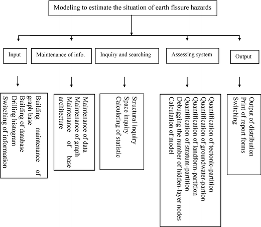
Architecture of system

In this study, the simulating system of estimating the situation of earth fracture hazards integrates the function of office automation, handling objects and decision-making to transfer and communicate with each other. Its function includes five sections, which include information for inputting, maintaining, inquiring and searching; simulating and estimating earth fractures and info-output.
Module of input
The users can apply this module of function to input the information of earth fractures. The graph-base of the simulating system of estimating the situation of earth fractures supports all kinds of graphs, which include digital and auto-scan input, auto-plot by computer and switching of graphs and data in other systems.
Module of maintaining information
Users can apply this module of function to edit the graphs and data from their base. This research is based on Mapinfo's graph base and it contains various users with its powerful function in graph editing. The users can modify, add and delete elements of graphs (dot, line and plate) or the whole graph, and also fragment, revolve and transfer the graph by using the module of function.
Inquiry and searches
This system develops the powerful function of inquiry by fully exerting the integrative ability of the integration system to manage data. The users can query the database and graph base at the same time by using a dialog box of SQL. In addition, it provides a tool for querying conveniently and rapidly. It is very simple to inquire regarding the information of concrete special objects and is completed by clicking an image.
Estimation of activity of earth fractures
Using the data in the special database, the users can quantitatively handle the factors that cause the hazards under the function of space, conduct buffer analysis, and plot isolines in the GIS software.
Module of output
According to the user's need, the result of analysis can be displayed in as data, tables, reports or maps, printed, plotted or stored on disk or tape.
Conclusions
Both the assessment model and forecasting system of earth fracture hazards were developed with the acronym TGSG, taken from initial letters of four parameters (i.e., Tectonic, Groundwater, Stratum and Geomorphology) to evaluate the earth fracture hazard potential. Each parameter is given a rating range from 0 to 11. The most significant parameters have scores of 11 and the least significant have a score of 0. The TGSG index is made up of an overlapping of products rating for the four parameters. Once a TGSG index is computed, it is possible to identify areas that are more prone to earth fractures. The higher the TGSG index the greater the earth fracture hazard potential. The TGSG index provides only a relative evaluation tool and is not designed to provide absolute answers. In this study, five risk levels are identified; risky, less risky, intermediate, less safe and safe. The corresponding TGSG index is in the range 0.97–1, 0.89–0.97, 0.75–0.89, 0.43–0.75, 0.01–0.43, respectively (Fig. 9).

Comprehensive assessment and security classes of Yucishi earth fissure
Future prospects
-
1.
As a subsystem of the earth system, earth fractures and their environments have essential attributes of the earth system, such as imbalance, nonlinear, self-organizing, self-comparability, orderliness and randomness, which are the focus of nonlinear theories. Based on the analysis in assessment of the formation mechanisms and nonlinear properties of earth fractures, acceptable results have been made in assessment of the situation of earth fractures hazards and its forecasting by using the coupling technology of ANN and GIS. This study theoretically shows guiding information in establishment and improvement of an assessing and forecasting system of geological hazards in China.
-
2.
According to the characteristics of earth fracture hazards, which are controlled by multi-factors, a multidisciplinary approach is taken. With the self-organizing ability of ANN, and powerful spatial analysis and processing function of GIS, multiple sources of information are overlapped. The assessing and forecasting systems of the situation of earth fracture hazards are developed for the city of Yuci. The study provided a solid basis for further development of the region and could help to achieve office automation in Yuci.
-
3.
The classification of earth fracture hazards induced from this study will be used for protection of the highway, the facilities of pile-net and the buildings in the risk areas, it will help adjust the city plan, city construction, and resource development of Yuci City, Shanxi Province.
References
Jian Z, Wu Q, Sui W (1999) The formation mechanism of earth fissures in Lingfei and their developing conditions (in Chinese with English abstract). Press of China University of Mining and Technology, Beijing
Jiao L (1990) ANN theory system. (in Chinese with English abstract). Press of Xi'an University of Electron Sciences, Xi'an
Wang J (1992) The distribution and earth fissures in China and its risk assessment (in Chinese with English abstract). Proceedings of the 4th National Engineering Conference (1). Ocean Press, Beijing
Wei Y (1990) The ANN-modeling studies on geological hazards and its assessment (in Chinese with English abstract). Natural Hazards Newsletter, vol 6, no 2, 1990
Xie G (1988) Earth fissures (in Chinese with English abstract). Earthquake Press, Beijing
Acknowledgements
This paper was made possible by the national Environmental Protection funding project, and has benefited from useful discussions with Dr. Wanfang Zhou and Ms. Jie Wang.
Author information
Authors and Affiliations
Corresponding author
Rights and permissions
About this article
Cite this article
Wu, Q., Ye, S., Wu, X. et al. A nonlinear modeling and forecasting system of earth fractures based on coupling of artificial neural network and geographical information system—exemplified by earth fractures in Yuci City, Shanxi, China. Env Geol 45, 124–131 (2003). https://doi.org/10.1007/s00254-003-0865-3
Received:
Accepted:
Published:
Issue Date:
DOI: https://doi.org/10.1007/s00254-003-0865-3