
Abstract
The Ebro Basin is located in the northeastern quadrant of the Iberian Peninsula, in the southern foothills of the Pyrenees, and excavated by its homonymous river. It is one of the largest catchments areas in the Iberian Peninsula. Its climate is Mediterranean with both a continental and semi-arid tendency due to the rain shadow effect of the surrounding mountain ranges. The vegetation in dry areas is made up by several groups: (1) Forests and woodlands dominated by Quercus rotundifolia, Q. coccifera, Pinus halepensis, Juniperus phoenicea and J. thurifera, and represented in small patches due to deforestation; (2) Garrigue on limestone or on gypsum substrates; on the latter, a group of gypsophytes constitutes the core of the communities. (3) Grasslands, which can be divided into: non-steppic, dominated by Brachypodium phoenicoides and B. retusum; steppic, dominated by Lygeum spartum and Stipa species; heavily grazed, dominated by Poa bulbosa; and annual grasslands of plants with ephemeral life cycles. There are two edaphically exceptional ecosystems: salty depressions and riparian ecosystems. The first are populated by a set of communities of succulent Chenopodioideae, such as Microcnemum coralloides, Salicornia patula and, mostly Suaeda braun-blanquetii which plays the most relevant role, together with Limonium latebracteatum; and woodland communities with Tamarix canariensis and T. boveana; reed communities with Juncus maritimus, J. gerardii and J. subulatus.; and annual communities dominated by Aeluropus littoralis and Sphenopus divaricatus. The riparian ecosystems are formed by forests, with willows (Salix neotricha), poplars (Populus alba, P. nigra), ashes (Fraxinus angustifolia), alders (Alnus glutinosa) and elms (Ulmus minor). In this environment Scirpoides holoschoenus communities are frequent, as well as Cynodon dactylon grasslands. Some comments about land use, concerning deforestation and irrigation are made, highlighting the historically intense human pressure on this territory.
Access provided by CONRICYT-eBooks. Download chapter PDF
1 Introduction
The Ebro catchment area, located in the northeastern quadrant of the Iberian Peninsula (Fig. 12.1), lies at the southern foothills of the Pyrenees. It is excavated by its homonymous river, forming one of the largest hydrographic catchment areas in the Peninsula with an extent of 85,000 km2. The abundant waters, drained by the Ebro and its hierarchical fluvial network, flow into the Mediterranean Sea.

The Ebro Basin and its catchment area in the Iberian Peninsula
The notion of the Ebro Basin, or Ebro Depression, is not coincident with that of the Ebro Valley as the former only occupies the central portion of the Ebro catchment area (Fig. 12.1). The Basin is a triangular depressed geomorphological unit, at an average altitude of 200 m, concealed among the three main mountain ranges which surround it: the Pyrenees in the north, the Iberian Range in the south and southwest, and the Catalan Coastal Ranges in the east. The Ebro Depression was formed during the mid-Tertiary as a result of the orogenic activity of that period, which gave rise to a tectonic depression. This formed an interior sea that was disconnected from all of the surrounding oceans and filled with sediments from the eroded materials of the surrounding ranges. In this endorheic sedimentary basin intense lacustrine sedimentation took place during the Tertiary. This sedimentary regime determines that in the centre of the Depression there are materials of chemical sedimentation (evaporites) such as gypsum or salt, with limestone in the upper strata of the hills. In the peripheral areas detrital materials such as conglomerates (beside the mountain foothills), sandstone or marl dominate. These Tertiary materials are arranged in horizontal layers as no relevant tectonic activity has folded them. As a result of this sedimentary endorheic regime, the interior lake of the Ebro Basin reached an elevation up to 200 m above the level of the open sea, enforced by accumulation of sediments in the lake. This rise in the level of the waters facilitated the change into an exorheic regime at the end of the Tertiary as a connexion with the Mediterranean Sea opened and the interior lake emptied into it. At that time the Ebro fluvial network was established as we know it today, and the sediments started to erode producing the characteristic relief of this territory. Such relief is typical of a sedimentary basin, having the following structural elements: platforms, glacis, terraces and alluvial plains. The former are flat hilltops called muelas, which are monadnocks or non-eroded remains of the top of the original sedimentary formation. These high platforms dominate the landscape in the central portion of the Depression, causing quite an abrupt relief (Fig. 12.2). Some examples are the Sierra de Alcubierre (822 m), Montes de Castejón (744), El Castellar (742), La Muela de Borja (700), La Plana de la Negra (646) and La Muela (627). Conservation of those summits is due to their having upper calcareous hard strata which prevent them from being easily eroded.

Monadnocks in the central portion of the Ebro Basin as those of the Bardenas Reales in southern Navarra
The glacis are the result of the accumulation of materials dug from the muelas and deposited on their slopes. These glacis were formed by an extensive network of small valleys (vales) that resulted from the erosion by temporary streams in a spasmodic regime, characteristic of a highly seasonal climate.
The alluvial plains are often concealed by terraces and correspond to different morphoclimatic events of the Pleistocene.
The fluvial terraces occupy the lower stretches of the valleys, relative to the main rivers which cross the Depression: the Ebro and its tributaries Ega, Arga, Aragón, Gállego, Cinca and Segre on the left, and Oja, Najerilla, Iregua, Alhama, Jalón, Huerva, Martín and Guadalope on the right.
Such morphology is produced under conditions of low vegetation cover, which favours the laminar flux of the runoff water, and is probably related to a severe climate, i.e. low rainfall regime (arid or semiarid) and low temperatures. Such conditions are consistent with those that are supposed to have reigned in southern Europe during the Pleistocene ice-ages.
For a long time it was accepted that several territories in central Iberia have a steppic character, an idea that was launched by Willkomm (1852, 1896) and later sustained by the German plant geographic tradition (Jäger 1971). It was speculated that some plants, such as Krascheninnikovia ceratoides and others, reached the Iberian Peninsula from Central Asia during the Messinian crisis in the upper Miocene. This idea was progressively discarded as detailed studies were made during the twentieth century (Huguet del Villar 1925; Terradas 1986) and today it is generally accepted that the Ebro Basin is a Mediterranean territory in terms of its current climate, flora and vegetation, although it has some features of the central Asian steppes, with which it was probably connected in some periods during the Tertiary. Looking at the current situation, we can say that the conditions of the Ebro Basin can be qualified as totally Mediterranean. This does not exclude the possibility that during the cold and dry episodes of the Pleistocene some regions in central Iberia could have been covered by a wooded steppe or even by a treeless steppe. Summarizing, the current landscape of the Ebro Basin, with abundant gypsiferous substrates, seems to have its origin in a steppic period under an arid and cold Mediterranean climate. Later, after several fluctuations, the climate has evolved to the current state, also dry and quite continental, but with not such cold winters. If we accept this interpretation, we can compare some vegetation patterns existing today, such as the hard grasslands of the Stipo parviflorae-Lygeetum sparti in mosaic with juniper woodland of the central basin, with that in other steppic areas in Turkestan and other Mediterranean territories.
1.1 Climatic Features
As pointed out above, the Ebro Basin is completely immersed in the Mediterranean climatic area of southern Europe, with a dry summer. More precisely, we can establish that the whole basin is in the meso-mediterranean thermotype and the ombrotypes vary between subhumid-dry in the periphery and semi-arid in the core. In some areas of the central districts, the steppic variant can be recognized, which probably was much more widespread in the cold phases of the Pleistocene. Within this, we can highlight some features which can distinguish this area from the neighbouring ones and make the Ebro Depression a climatically well characterized territory.
Rain Shadow from the Surrounding Mountain Ranges
This is a common feature of all valley bottoms in the world, and the Ebro valley is not an exception; it is caused by the Pyrenees, the Iberian System and the Catalan Coastal Ranges. All of them, but particularly the Pyrenees, are responsible for a huge rain shadow effect which is at a maximum in the central core of the depression. This is the main reason for the enhanced drought of this central sector (Bardenas-Monegros) which also experiences low levels of relative humidity and a high continentality, i. e. a large temperature oscillation between summer and winter (cold winters and torrid summers).
Thermal Inversion
Another feature of the climate of the Ebro Basin is the frequency and intensity of episodes of thermal inversion, which affect to a large extent the lowlands of the central basin. It produces a cooling effect in these areas, increasing their climatic continentality, thus explaining the occurrence there of species typical of higher altitudes, such as Juniperus thurifera, and the absence of some more thermophilous ones, such as Quercus rotundifolia.
Wind
Finally, another unpleasant feature of the climate in this region is the frequency and intensity of the northwestern wind, called cierzo, which blows frequently and is enhanced by the relief and the lack of barriers in the landscape. When this wind blows hard, it is one of the most uncomfortable events happening during winter.
Following human and geomorphological criteria, the Ebro basin can be divided into several districts as shown in Fig. 12.3.

Geographical districts of the Ebro Basin. (1) La Riojilla; (2) Rioja Alta; (3) Sonsierra; (4) Rioja Baja; (5) Ribera Estellesa; (6) Navarra Media Oriental; (7) Las Bardenas; (8) Ribera Tudelana; (9) Tarazona; (10) Cinco Villas; (11) Campo de Borja; (12) Zaragoza; (13) Campo de Cariñena; (14) Hoya de Huesca; (15) Somontano; (16) Los Monegros; (17) Campo de Belchite; (18) Bajo Aragón; (19) Llitera; (20) Segriá; (21) Noguera; (22) Pla d’Urgell; (23) Segarra. LO Logroño, HU Huesca, L Lleida
2 Forests and Woodlands
The Ebro Basin is an area subjected to severe summer drought and continentality, conditions that determine the dominance of evergreen sclerophyllous forests and shrublands, which share the territory with semideciduous marcescent forests in the most humid areas and with juniper coniferous forests in the areas with more extreme temperatures. Furthermore, due fundamentally to the human factor, the landscape offers a semblance in which forests and woodlands are rare, almost absent, maximizing the appearance of aridity and extreme conditions of the area. Forests are supposed to have been cut down by humans in historic times (Terradas 1986) and the current state is supposedly mostly the result of human action. Moreover, not only the ancient history of human settlement but also the slowness of the regeneration capacity of the forest ecosystems of the area share responsibility for the current state, showing a picture of a devastated treeless country. However, most of the area of this territory is considered to have a potential for forest, woodland or tall shrub vegetation. Concerning this, some remnants of natural populations of native trees and certain patches which have survived till now, permit us to reconstruct a situation with the forests occupying their potential area and depict its diversity, structure and composition. We will classify the different types of forests which can be found in the Ebro Basin by their dominant trees.
2.1 Quercus rotundifolia (Holm Oak) Forests and Woodlands
They occupy the peripheral area of the basin, where rainfall is above 350–400 mm and conditions permit growing holm oak forests. The general association for the majority of holm oak forests in the Ebro Basin is the Quercetum rotundifoliae, which was first described by Braun-Blanquet and Bolòs (1958). The remnants of this forest type are irregularly distributed in the territory being mostly represented by isolated trees, but there are some examples in the Sierra de Alcubierre, the Montes de Castejón and in La Plana de la Negra (Bardenas Reales). All the stands and individual trees present mutilations from being severely pruned for firewood, as a signal of the strong human pressure upon this vegetation. The surviving stands are young and of low height, being now favoured by the replacement of firewood by fossil fuels in domestic uses. The diversity of vascular plants in these forests is quite low due to the severe climate. Together with Quercus rotundifolia, often accompanied by Pinus halepensis, there are some tall shrubs such as Lonicera implexa, Quercus coccifera, Rhamnus alaternus, Prunus spinosa and Juniperus oxycedrus. Chamaephyte communities are favoured by the high light conditions created by the gaps in the canopy of the taller vegetation. They are formed by the surrounding scrub species such as: Centaurea linifolia, Thymus vulgaris, Genista scorpius, Coronilla minima, Bupleurum rigidum, Rosa pimpinellifolia, etc. The lianoid habit is only represented by Rubia peregrina and the herb layer is formed by Teucrium chamaedrys, Brachypodium retusum and Carex hallerana. There is a colder variant on the northern slopes of the higher elevations with Arctostaphylos uva-ursi subsp. crassifolia. The main sources of data are those of Braun-Blanquet and Bolòs (1958), Bolòs (1961, 1996), Molero et al. (1998) and Ursúa (1986). In the northern part of the depression, in the transition to the Pyrenees, those forests show an important increase in more moisture demanding plants, such as Buxus sempervirens, Brachypodium phoenicoides, Emerus major, Helleborus foetidus and even Quercus pubescens, Quercus faginea, Pinus nigra subsp. salzmanii, and Lavandula angustifolia subsp. pyrenaica. This floristic change, indicative of the rainfall gradient towards the foothills of the Pyrenees, permits the recognition of the association Buxo sempervirentis-Quercetum rotundifoliae.
2.2 Quercus faginea Forests
This marcescent or semideciduous oak is endemic to the Iberian Peninsula, where it occupies submediterranean areas, usually on marly base-rich substrates. It is thus distributed in the central north-eastern quadrant of Iberia and, within the Ebro Basin, it occurs only on its northern fringe, in the transition to the Pyrenean foothills contacting the Quercus pubescens dominated forests. There it occupies a strip between Quercus rotundifolia forests (Buxo-Quercetum rotundifoliae) and the Quercus pubescens groves of the Pyrenean lowlands (Buxo-Quercetum pubescentis). In such a situation, hybridization between both oaks, i.e. Quercus x allorgeana (Quercus subpyrenaica) is frequent. The association for those forests is the Violo willkommi-Quercetum fagineae, and it is represented by scattered patches in the northern sector of the territory, always constituted by young stands of low height and high stems density. As usual in submediterranean semideciduous forests, the abundance of light inside the forest, combined with the richness of nutrients, produces a dense cover in the understory vegetation, particularly in the shrub layer, which is formed by many spiny species, making it practically impassable. The tree layer is formed mostly by Quercus faginea and hybrids, but often individuals of Sorbus domestica, Acer campstre, Acer monspessulanum and Quercus rotundifolia share the canopy. The shrub layer is species-rich and dense, and formed by typical species of European submediterranean forests, such as Amelanchier ovalis, Viburnum lantana, Buxus sempervirens, Cornus sanguinea, Crataegus monogyna, Emerus major, Ligustrum vulgare, Lonicera etrusca, Juniperus communis, Prunus mahaleb, Prunus spinosa, Rhamnus saxatilis, etc. The herb layer is formed by Brachypodium phoenicoides, Helleborus foetidus, Paeonia officinalis subsp. microcarpa, Primula veris subsp. columnae, Tanacetum corymbosum, Viola willkommii, and others. The Mediterranean influence is conspicuous and represented by Carex hallerana, Juniperus oxycedrus, Quercus coccifera and Teucrium chamaedrys. Information about this forest type is available in Rivas-Martínez et al. (1991).
2.3 Juniperus thurifera Woodlands
The natural vegetation in the central section of the Ebro Basin, in the district called Los Monegros, is a juniper woodland. The main species are Juniperus thurifera and Juniperus phoenicea; they form an open woodland of steppic appearance, similar in physiognomy to those of southwestern North America (Utah, Nevada and Arizona) or some north African and western and central Asian areas (Morocco, Cyrenaica, Anatolia, Transcaucasia, southern Turkestan and the upper Indus Valley). This vegetation is an open woodland of Juniperus thurifera, a juniper tree of medium height, distributed in several western Mediterranean countries (western Alps, French Massif Central, Spain, and Moroccan Grand Atlas) where it is found in areas under continental climatic conditions. Its distribution in central Iberia is concentrated in the central-eastern midlands, usually at altitudes above 800 m, but in the Ebro Basin it is found at significantly lower altitudes in the central core area of the basin, where continentality is highest. The existence of this woodland in this area is attributed to the high frequency of thermal inversion episodes, since Juniperus thurifera commonly occurs at substantially higher elevations (Terradas 1986). It also prefers deep soils, avoiding the drier shallow rocky soils on the steep slopes and rims. The association described for this vegetation is the Juniperetum phoeniceo-thuriferae. It has a low number of forest plants, such as Asparagus acutifolius, Ephedra nebrodensis, Juniperus phoenicea, Juniperus thurifera, Pinus halepensis, Quercus coccifera, Rhamnus alaternus, Rhamnus lycioides, etc. In the broad gaps which remain open between the trees, the corresponding scrub develops, almost always dominated by Genista scorpius, Rosmarinus officinalis and Thymus vulgaris. There is not one stand in which the forest closes its canopy and casts a continuous shade on the understory. The particular growth and reproductive strategy of junipers and the extreme conditions of drought and continentality combined with human action are responsible for the few remaining examples of this forest type presenting the appearance of an open wooded scrub more than of a true forest. Moreover, most of the original juniper forests have disappeared and only a few examples remain: Bujaraloz-Retuerta de Pina, Castejón de Monegros, Pallaruelo, Monegrillo (Fig. 12.4), Leciñena and few others. Those remnants are found in the district known as Los Monegros, a name clearly indicating that the area was densely covered by a dark tall vegetation (monte negro), very probably corresponding largely to this juniper woodland (Fig. 12.4). Information about this woodland is available in Braun-Blanquet and Bolòs (1958).

A fragment of the Juniper woodland with Juniperus thurifera near Monegrillo
2.4 Tall Quercus coccifera Shrubland (Macchia) and Pinus halepensis Woodlands
This ligneous sclerophyllous shrubby vegetation is extensively represented in the Ebro Basin, where it can be found scattered on the hilltops and slopes where agriculture is not possible. It forms a mosaic with scrub of Rosmarinus officinalis, Genista scorpius, Dorycnium pentaphyllum and Thymus vulgaris and usually shows a dominance of Quercus coccifera, which is almost always accompanied by Rhamnus lycioides, Rhamnus alaternus, Juniperus oxycedrus, Juniperus phoenicea and Pinus halepensis. The physiognomy of this vegetation is that of a tall and dense shrubland in which pines are often leaning out, producing the aspect of a wooded shrubland or even a true pine forest. Rubia peregrina is a prevailing/predominant vine which climbs across the dense shrubs, and the herb layer is dominated by Brachypodium retusum. The association encompassing those stands is the Rhamno lycioidis-Quercetum cocciferae, distributed in the base-rich central territories of the Iberian Peninsula. It constitutes the potential natural vegetation of the central part of the Ebro Basin (Bardenas and Monegros sector). In this area, continentality and summer drought are more intense and this shrubland occupies an altitudinal range between 400 and 700 m. Substrates are mostly of marl, limestone and gypsum, in any case basophilous and lime-rich. In areas where temperatures are higher in winter –southern slopes, gorges, low altitude areas, etc.– this shrubland is enriched with Pistacia lentiscus, a thermophilous species indicative of a lower incidence of frosts and low temperatures. This variant is the dominant one in the low altitude area surrounding Caspe. In contrast, at higher elevations (between 550 and 700 m) Carex humilis indicates a colder and moister variant. Examples of this vegetation are abundant all over the Ebro Basin, partially covering the hills which were traditionally used for grazing. In recent times, rural abandonment and the decrease of grazing pressure have caused a recovery of this vegetation all over the territory. Information about this woodland is available in Braun-Blanquet and Bolòs (1958). Along the northern fringe of the Ebro Basin, in the transition to the foothills of the Pyrenees, Quercus coccifera shrublands are enriched with boxwood, Buxus esmpervirens, enabling one to distinguish two communities: the first one with Phillyrea angustifolia, Lonicera implexa and Pistacia therebinthus, plants not frequent in the central districts of the basin, which form the Quercetum cocciferae buxetosum sempervirentis, related to the Quercus rotundifolia forests; and the second one, more humid and expanding northwards to the pre-Pyrenees, the Ononido fruticosae-Buxetum sempervirentis, with Coriaria myrtifolia, Hepatica nobilis, Ononis fruticosa and Thalictrum tuberosum, which is related to the Quercus faginea forests of the area. Further information about these Buxus sempervirens-rich shrublands is available in Bolòs (1961) and in Braun-Blanquet and Bolòs (1958).
2.5 Rocky Woodland of Boxwood and Juniper
This type of woodland is formed by Juniperus phoenicea and Buxus sempervirens, together with other shrubs such as Rhamnus alaternus, Amelanchier ovalis, Asparagus acutifolius, Helichrysum stoechas, etc. It occupies the calcareous rocky rims, boulders and outcrops of the narrow valleys surrounding the basin, in steep rocky slopes almost without soil. The association for these woodlands is the Buxo sempervirentis-Juniperetum phoeniceae, common in all the ragged districts of the eastern Iberian Peninsula and southern France.
3 Scrub
Ligneous vegetation dominated by chamaephytes and other dwarf woody plants, often spiny and/or aromatic, with small leaves, hairs and glands, constitute one of the most characteristic features of the landscape in Mediterranean countries. This vegetation, called matorral in Spanish, contains an important proportion of the indicator and endemic taxa of each of the provinces of that region. This abundance of stenochorous plants is probably due to the origin of this flora and vegetation in the late Tertiary as an adaptation to the increasing aridity of the climate. This process took place in the absence of human disturbance when landscapes were covered mostly by mature vegetation and degraded secondary habitats were isolated, occupying small patches scattered like islands, thus enhancing the speciation of its flora. When humans started to destroy mature vegetation during the Neolithic, particularly forests and tall shrublands, the situation reversed and the scrub expanded as a result of human land use, particularly animal husbandry. This has resulted in the current situation, in which these matorrales have become the vegetation type covering the majority of the area not used for agriculture. They contain numerous taxa, among which there are many endemics. In the Ebro Basin substrates are almost exclusively basophilous and thus the scrub is clearly responding to that condition. However, the mineralogical composition of the bedrock, specifically the proportion of calcium sulphate (gypsum), makes it possible to distinguish two main groups in the Ebro Basin scrub.
3.1 Scrub on Limestone and Marl
We can differentiate several geographically distributed associations (Fig. 12.5), sorted by temperature and moisture gradients. The broad territories of the central districts of the Ebro Basin are dominated by the most extended association: the Rosmarino officinalis-Linetum suffruticosi. This vegetation type contains a combination of thermophilous plants of coastal distribution, such as Helianthemum marifolium, Linum suffruticosum and Thymelaea tinctoria, with some regional endemics, such as Centaurea linifolia, and a large group of species of wide distribution, such as Bupleurum fruticescens, Genista scorpius, Fumana ericifolia, Fumana thymifolia, Helianthemum violaceum, Koeleria vallesiana, Rosmarinus officinalis, Teucrium capitatum, Teucrium gnaphalodes, Thymus vulgaris and many others. The alfa diversity of vascular plants is high, with the average number of species per relevé being 25. It is a scrub of low density, usually covering around 30 to 40% of the total area, and a height of 20–60 cm. The abundant aromatic species confer a typically scented character to this vegetation. Information about this association is abundant: Braun-Blanquet and Bolòs 1958, Loidi et al. 1997, Molina et al. (1993).

Areas of the five main limestone scrub associations of the Ebro Basin: (1) Salvio lavandulifoliae-Ononidetum fruticosae; (2) Rosmarino officinalis-Linetum suffruticosi; (3) Teucrio aragonensis-Thymetum fontqueri; (4) Sideritido spinulosae-Lavanduletum latifoliae; (5) Cytiso fontanesii-Cistetum clusii
In addition to the above mentioned association, a number of associations occupy the transition to the outer territories in the periphery of the basin (Fig. 12.5):
-
1.
In the eastern part of the depression, where altitudes are lower and some thermophilous plants enter into the depression from the coastal Mediterranean area following the Ebro river up, the dominant association is the Cytiso fontanesii-Cistetum clusii, with Cistus clusii, Coronilla minima subsp. lotoides, Cytisus fontanesii, Fumana hispidula and Globularia alypum. Further information in Bolòs (1973), Braun-Blanquet and Bolòs (1958), Molina et al. (1993)
-
2.
The transition to the Iberian central high plateau (meseta) on the southern fringe of the basin is occupied by the association Sideritido spinulosae-Lavanduletum latifoliae, which is characterized by plants of the central highlands of the Iberian Peninsula, such as Helianthemum cinereum subsp. rotundifolium, Lavandula latifolia, Salvia lavandulifolia and Teucrium expassum, mixed with plants of the central basin lowlands. Information in Molina et al. (1993).
-
3.
The transition to the northern pre-Pyrenean fringe is occupied by the association Teucrio aragonensis-Thymetum fontqueri, with Teucrium aragonense, Thymus fontqueri, Carex humilis, Convolvulus cantabrica, Genista hispanica, Helianthemum oelandicum subsp. italicum, Satureja montana and others which indicate cooler and more humid conditions. Information in Bolòs 1961, Loidi et al. (1997), Molero and Vigo (1981).
-
4.
In the northwestern corner of the basin, the Rioja region, the association is the Salvio lavandulifoliae-Ononidetum fruticosae with Ononis fruticosa, Salvia lavandulifolia and Helianthemum cinereum subsp. rotundifolium which replaces Helianthemum marifolium, common in the central part of the basin. Other diagnostic species are Euphorbia minuta, Thymus loscosii and Helianthemum apenninum subsp. stoechadifolium. Information available in Fernández-González et al. (1986) and in Loidi et al. (1997)
3.2 Scrub on Gypsum
Gypsum substrates are frequent in several of the sedimentary basins of the Iberian Peninsula and very common in the Ebro Basin (Fig. 12.6). In this territory most of them are evaporitic rocks formed as a result of lacustrine sedimentation during the Miocene, when the Ebro Basin was an interior lake without connection to the Mediterranean Sea. They are easily recognized by the white flat strata appearing in the hills. There are also others group of gypsum outcrops of earlier origin formed in the continental Tertiary -Oligocene and early Miocene- which show a folded stratification and are abundant in the Ribera Estellesa and Rioja Baja districts. Such abundance of gypsum outcrops confers the landscape of many areas of the Ebro Basin a whitish colour, enhancing its steppic semblance and the impression of aridity to the observer. The soils found on such bedrocks are gypsisols, which under Mediterranean climatic conditions (severe summer drought) determine the existence of a very particular flora, specialized in inhabiting those gypsisols and often confined to them; these plants are called gypsophytes and almost all of them are Iberian endemics. This flora is distributed in other gypsum areas in the Iberian Peninsula too, and this results in a particular type of scrub in which generalist species mix with a number of gypsophytes. This is a special case of edaphic habitat, particularly widespread in the Iberian Peninsula, which constitutes one of its most valuable and original vegetation types in the European context (Fig. 12.6).

Gypsum scrub near Nuez de Ebro
The main species found in that scrub are the gypsophytes: Boleum asperum, Gypsophila struthium subsp. hispanica, Helianthemum squamatum, Herniaria fruticosa, Launaea fragilis, Launaea pumila, Lepidium subulatum, Ononis tridentata and Reseda stricta. They combine with a group of basophilous scrub plants of wider ecological scope such as Genista scorpius, Linum suffruticosum, Rosmarinus officinalis, Thymus vulgaris, Helianthemum syriacum, Fumana ericifolia, etc. The annual community inhabiting the gaps in between the scrub has two other gypsophytes: Chaenorhinum reyesii and Campanula fastigiata. The association grouping all the Ebro Basin gypsophilous scrub is the Helianthemo thibaudii-Gypsophiletum hispanicae, which has several variants depending on ecological conditions or territory (Loidi and Fernández-González 1994). There is abundant information about these communities in Báscones et al. (2011), Bolòs (1996), Braun-Blanquet and Bolòs (1958), Font (2011), Guardia and Ninot (2000), Loidi and Fernández-González (1994), Loidi et al. (1997), Molina et al. (1993), Rivas Goday et al. (1956), Villar et al. (2011).
A schematic view of the relationships between climatophilous forest types and scrub types sorted out according to a moisture gradient is shown in Fig. 12.7.

Scheme of the forest and scrub associations of the Ebro Depression in relation with the moisture gradient
4 Dry Grasslands
Herbaceous vegetation in Mediterranean countries presents adaptations to endure the severe summer drought. In the case of the Ebro Basin, summer aridity favors the accumulation of soluble ions in the upper layers of the soil, affecting sometimes the osmotic potential of the soil solution. Under such conditions, herbs, and particularly grasses, develop hard tissues in their leaves and stems, mostly sclerenchyma bundles, hairs and silicified epidermal cells, which prevent water loss and predation by herbivores. Another adaptation of herbs to a dry season is becoming annual and spending the unfavourable season as seeds. Both types of strategies are found in the arid hills of the Ebro Basin, contrasting with the tender evergreen grasslands of the humid alluvial plains which can benefit from the shallow water table. We will focus on the dry grasslands as the humid grasslands will be treated as part of the riparian system.
4.1 Non-steppic Dry Grasslands
In the peripheral areas of the Ebro Basin, under conditions of lower aridity and continentality, these dry grasslands are widespread on potential areas of Quercus rotundifolia and Quercus faginea. The main association in the mentioned areas is the Ruto angustifoliae-Brachypodietum retusi, in which Brachypodium retusum is the dominant species. They form dense communities in areas where the soil is rich in clay, usually in foothills, often in combination with scrub patches. Avenula bromoides, Ruta angustifolia, Phlomis lychnitis, Convolvulus lineatus, Plantago albicans etc., are the most frequent plants, together with the inevitable high number of annuals visible only in spring, which intermingle in this perennial grassland occupying its gaps. In areas with higher moisture due to more rainfall or to edaphic accumulation, where the potential natural vegetation corresponds to Quercus faginea forest or to Populus alba in alluvial foothill positions, the dry grassland association is the Elytrigio campestris-Brachypodietum phoenicoidis, with Brachypodium phoenicoides and Elymus pungens subsp. campestris as the main species. Other perennial herbs are Festuca capillifolia, Hypericum perforatum, Medicago sativa, Festuca interrupta, Poa pratensis, Lotus corniculatus, Galium verum, Trifolium campestre, Daucus carota, Dactylis glomerata subsp. hispanica, etc.
4.2 Steppic Grasslands in the Central Basin
Perennial grasslands dominated by Lygeum spartum, Elymus pungens subsp. campestris and several Stipa species, all of them with strong root systems, are distributed in the central territories of the Ebro Basin, mostly in the Bardenas-Monegros sector, where aridity and continental conditions are extreme. These grass species, due to the relatively large size of their aerial parts as well as their rhizomatous systems, produce a high amount of organic matter. Thus, this vegetation enhances the development of the soils, producing fertile horizons which have traditionally been used for agriculture. They settle on gentle slopes or even in small depressions where soils can easily develop and fine materials accumulate (Fig. 12.8). The physiognomy given by such grasses, particularly Stipa, has induced these grasslands to be considered as steppic, due to its similitude with the central and eastern European steppic grasslands. These grasslands are locally called albardinares, as the most common grass, Lygeum spartum, is called albardín in Spanish, a name of Arabic origin. This grass was commonly used in ancient times to make ropes, shoes (espadrilles) and baskets because of its strong fibers. Other common species found in these grasslands are Brachypodium ramosum, Dactylis glomerata subsp. hispanica, Koeleria vallesiana and Sedum sediforme. Very often, these grasses do not cover the entire surface but tufts of them are spaced out leaving gaps in which many annuals get established. Such annual communities form a mosaic with the tufts of the steppic grassland, in a characteristic composition of both entities, already highlighted by Braun-Blanquet and Bolòs (1958). There are two associations in the Ebro Basin: firstly, on calcareous soils, with no salinity and flat terrain or on very gentle slopes the Stipo parviflorae-Lygeetum sparti, with dominance of Stipa parviflora and Lygeum spartum and sometimes with Stipa lagascae. Secondly, on gypsiferous soils, where a certain salinity is also recorded, and on slightly steeper slopes, there is the association Agropyro pectinati-Lygeetum sparti, with Agropyron cristatum subsp. pectinatum, and dominated by Lygeum spartum. At the foot of the gypsiferous hills, the soils often become saline due to the accumulation of soluble ions in their upper layers. This circumstance is indicated by the presence of the succulent Aizoon hispanicum. These steppic grasslands are found in territories where juniper woodland and Quercus coccifera shrubland are the potential natural vegetation. Information about these communities can be found in Berastegi (2013), Braun-Blanquet and Bolòs (1958) and Ursúa (1986).

“Albardinar” or Lygeum spartum grassland in a small depression between the hills in the central Ebro Basin
4.3 Annual Grasslands
The Mediterranean Region is well known for having a high diversity in annual plants. Annuality can be considered as one of the adaptations to the severe summer drought in which plants avoid the unfavorable season by spending it in the state of seed. The plants germinate in autumn with the first rains and stay in their seedling stage during the whole winter. In early spring they start to grow rapidly and they flower and fruit in a very short time in a manner that by late spring almost all have already sown their numerous and little seeds and are wilting before the first strong heat waves of the summer arrive. This strategy is performed by a large number of species belonging to a variety of families but that have some traits in common: small size, fast growth and explosive flowering and seed production. These annual grasslands are usually very rich in species number and there is a long list of plants which are found in them:
Alyssum granatense, Alyssum simplex, Anagallis arvensis, Arenaria serpyllifolia, Asterolinon linum-stellatum, Astragalus stella, Atractylis cancellata, Bombycilaena erecta, Brachypodium dystachyon, Bupleurum baldense, Bupleurum semicompositum, Campanula erinus, Cerastium pumilum, Clypeola jonthlaspi, Crucianella angustifolia, Desmazeria rigida, Echinaria capitata, Euphorbia exigua, Euphorbia falcata, Euphorbia sulcata, Filago gallica, Filago pyramidata, Galium parisiense, Hedypnois rhagadioloides, Helianthemum ledifolium, Helianthemum salicifolium, Hippocrepis multiliquosa, Holosteum umbellatum, Hornungia petraea, Hymenolobus procumbens, Linum strictum, Lomelosia simplex, Malva aegyptia, Malva trifida, Medicago minima, Medicago orbicularis, Neatostema apulum, Paronychia capitata, Plantago afra, Platycapnos spicata, Polygala monspeliaca, Senecio gallicus, Sherardia arvensis, Sideritis montana, Trifolium scabrum, Trigonella monspeliaca, Vulpia ciliata, Vulpia myuros, Wangenheimia lima, Xeranthemum inapertum, Ziziphora hispanica, etc.
There is a broad association gathering most of these communities in the Mediterranean Iberian Peninsula which is well represented in the Ebro Basin on limestone and marl substrates: the Saxifrago tridactylitae-Hornungietum petraeae with Saxifraga tridactylites as indicator species. On gypsum substrates there is another association: the Chaenorhino reyesii-Campanuletum fastigiatae with the annual gypsophytes Campanula fastigiata, Chaenorhinum exile and Chaenorhinum reyesii. Information about these grasslands is available in: Báscones and Ursúa (1986), Berastegi (2013), Loidi et al. (1997).
4.4 Grasslands Subjected to Heavy Grazing
Some areas, such as paths, livestock (mainly sheep) trails and places where animals graze intensively, are covered by special grasslands dominated by Poa bulbosa with some other species adapted to grazing, such as Astragalus sesameus, Convolvulus lineatus or Plantago albicans, and many other therophytes. These grasslands are adapted to intense grazing during the humid season, i.e. from autumn to spring, and wilt (agostan) in summer. For that reason they cannot be grazed in summer and the sheep have to find other ways of nourishment, i.e. wet grasslands nearby or move on to find grasslands which are green in summer, usually in mountain ranges. This causes a regular seasonal migration called transhumance, which in this case is due to seasonal drought (xerofugous), in contrast with the transhumance done by flocks in other regions where migration is prompted by seasonal cold, in a summer-winter pattern between highlands and lowlands (cryofugous). These grasslands are found in areas where traditional management of sheep has been performed for centuries, particularly along the tracks used by the animals. Some of the paths have been used since the track network system of the transhumance between the Pyrenees and the lowlands of the Ebro Basin, within the kingdoms of Aragón and Navarra, was established in the Middle Ages. In this territory there is the basophilous association Astragalo sesamei-Poetum bulbosae. Information about this grassland type is available in Berastegi (2013).
5 Nitrophilous Vegetation in Dry Environments
The Ebro Basin has been heavily populated since ancient times and it has been subjected to intense land use: agriculture and husbandry in different forms. This has produced a high variety of environmental situations in terms of deposition of nitrogen and phosphorus compounds, soil humidity, regularity and intensity of disturbance, etc. not only in cultivated and grazed areas but also in urban and peri-urban areas. Those different biotopes are occupied by a diverse set of plant communities, commonly called nitrophilous, because all of them require a high amount of nitrogen compounds, mostly resulting from the decomposition of proteins from accumulated organic matter. These environments are also known as hemerobic, as they are strongly linked to human activity. Other terms used to refer to them are ruderal (from ruderis = rubble), indicating that they are near human buildings, or viarious (from via = road) as many of them are found at the edges of roads and paths. Summarizing, three factors condition this vegetation and its diversity: abundance of nitrogenous and phosphate compounds of organic origin, intensity and type of disturbance (soil digging or trampling) and moisture of the soil (Fig. 12.9).

Scheme of the dry nitrophilous associations of the Ebro Depression in relation to disturbance (soil digging, trampling, etc.) and abundance of N and P
5.1 Low Soil-Disturbance, Shrubby Nitrophilous Vegetation
In semi-arid to arid territories, like the central districts of the Ebro Basin, nitrified sites which suffer low levels of disturbance can develop a shrubby community in which ligneous Chenopodioideae are particularly frequent. This also occurs in all the Mediterranean, Irano-Turanian and Saharo-Arabian regions, and it seems to be caused by the long permanence of soluble nitrates and phosphates which are slowly leached by the low rainfall or even tend to accumulate in the soil. The most widespread association is the Salsolo vermiculatae-Peganetum harmalae, with Artemisia campestris subsp. glutinosa, Camphorosma monspeliaca, Marrubium alysson, Peganum harmala, Salsola vermiculata (sisallo), and other therophytes such as Onopordum nervosum, Bromus rubens and many others. Those sisallares are very abundant in the lower parts of the depression, dominating field edges, road and track borders and any marginal land left after human exploitation. As a result of the greyish colour of the silsallo, this vegetation is responsible for a significant increase in the arid look of the cultural landscape in the territory. In areas where soil humidity is higher, and often also salinity, the species Atriplex halimus appears dominating the communities and gives way to the association Salsolo vermiculatae-Atriplicetum halimi. Under certain grazing pressure, Artemisia herba-alba dominates and these communities can cover wide areas in abandoned fields. They are gathered under the association Salsolo vermiculatae-Artemisietum herba-albae.
5.2 Herbaceous Ruderal and Viarious Vegetation
When disturbance, i. e. soil digging, removal of biomass, trampling, etc. is heavy, the response of the nitrophilous vegetation is to build herbaceous communities. Depending on the disturbance regime and intensity, amount of nitrogen-rich matter added, and other soil traits constraints, different community types result. Under extremely high nitrification conditions, the association is the Chenopodietum muralis, an open community type which is unstable as it varies its floristic composition easily due to its dependence on the high input of ammonia compounds. It is formed by a high number of Chenopodioideae, such as Chenopodium album, Chenopodium ambrosioides, Chenopodium murale, Chenopodium opulifolium, Chenopodium urbicum, Chenopodium vulvaria, as well as Amaranthus blitoides, Amaranthus deflexus, Amaranthus retroflexus, Sisymbrium irio, Urtica urens, Xanthium spinosum, etc. When the nitrification intensity decreases, many Chenopodium species disappear and the association Sisymbrio irionis-Malvetum parviflorae is established. It is dominated by colourful flowering species such as Anacyclus clavatus, Bromus rubens, Descurainia sophia, Erodium cicutarium, Erodium malacoides, Eruca vesicaria, Lamium amplexicaule, Malva parviflora, Papaver hybridum, Papaver rhoeas, Roemeria hybrida, Sisymbrium irio, Sisymbrium orientale, Sisymbrium runcinatum, Urtica urens, etc., which explode in colours in spring and decorate ephemerally the human-transformed areas, particularly the rural ones. If the nitrification is lower, a spiny vegetation of high biomass formed by annual and biannual thistles of the genera Carduus, Cirsium (cardos), Carthamus, Centaurea, and Onopordum (tobas) is established, where some specimens of the tallest species clearly stand out. The widespread association inhabiting plowed soils where organic matter, either of animal or of vegetal origin, such as straw from cereal harvesting, accumulates is the Onopordetum castellani and the most common species are Carduus bourgeanus, Carduus pycnocephalus, Carduus tenuiflorus, Carthamus lanatus, Centaurea calcitrapa, Cirsium vulgare, Onopordum acanthium, Onopordum corymbosum, Onopordum nervosum subsp. castellanum, Silybum eburneum and others. If soil humidity is a bit higher because the terrain is flat or a small depression, Silybum marianum dominates the thistle communities accompanied by Arctium minus, Ballota nigra and Marrubium vulgare. This is the association Silybo-Urticetum.
The viarious vegetation, i. e. that which is linked to roads, trails and pathways covering the moderately trampled areas, such as the central lane of lightly trampled paths or the edges of trails submitted to more intense traffic, are also part of the nitrophilous vegetation of any region. The areas which suffer the heaviest trampling intensity endurable by vascular plants are inhabited by the association Coronopodo procumbentis-Sclerochloetum durae, a vegetation of small prostrate therophytes covering a low proportion of the floor area. This is a community type with few species specialized in this highly disturbed habitat: Coronopus didymus, Coronopus squamatus, Poa annua, Polygonum aviculare, Sagina apetala, etc. Along the edges of roads, where trampling is lower, the vegetation increases dramatically in cover, biomass and height, being dominated by grasses (Hordeum, Bromus). These grasslands often form a continuous strip along the edges of the trails and fill, like a matrix, all the urban and peri-urban spaces in villages and towns. The association is the Hordeetum leporini and the main species are Hordeum murinum subsp. leporinum, Avena barbata, Anacyclus clavatus, Bromus rubens, Bromus diandrus, Bromus hordeaceous, Bromus madritensis, Bromus tectorum, Capsella bursa-pastoris, Cardaria draba, Erodium ciconium, Erodium malacoides, Lolium rigidum, Malva sylvestris, Rostraria cristata, Sisymbrium irio, etc. In areas of lower nitrification, like abandoned crop fields and edges in remote, rather scarcely walked tracks, edges of pastures and so on, the vegetation becomes dominated by Aegilops species, particularly Aegilops geniculata and Aegilops triuncialis, which are accompanied by Convolvulus arvensis, Medicago minima, Medicago rigidula, Medicago sativa, Trifolium angustifolium, Trifolium campestre, Trifiolium scabrum and others. This is the association Medicagini rigidulae-Aegilopietum geniculatae.
Concerning the weed communities that were used to be found on crop fields mixed with cultivated plants, the current intensive use of herbicides in agricultural practices has caused their practical disappearance, with the consequent loss of plant diversity. For that reason, it has been considered pointless to mention and comment on them.
Nitrophilous communities contribute substantially to the plant diversity of an area, and they should be considered as part of the biological diversity patrimony in any territory. Thus, any comprehensive conservation policy should take into account this vegetation and try to preserve it from disappearing/becoming extinct. Animal populations in rural areas are decreasing and the use of concrete and asphalt is increasing, encroaching on all patches that used to be occupied by this ruderal vegetation. Data about this vegetation for the Ebro Basin are found in Braun-Blanquet and Bolòs (1958), Loidi et al. (1997), Ursúa (1986).
6 Salt Marshes
The history of the sedimentary processes in the Ebro Basin, which over a long period in the Miocene was under endorheic conditions, has resulted in a high proportion of the sedimentary materials deposited being evaporitic, i.e. resulting from the deposition by chemical precipitation of soluble compounds, usually CaSO4, CaCO3 and NaCl. Those salts were dissolved in the lake water covering the depression during the Tertiary and precipitated when oversaturation happened under high evaporation conditions with high aridity. As a result, the Ebro Basin is rich in materials with a high content of gypsum and salt, which have a tendency to accumulate in the depressions where drainage has a low efficiency or is non-existent (arheic and endorheic). A few of these depressions have water permanently (Salada de Alcañiz), but most of them dry out in early summer, as soon as seasonal drought and high temperatures start, forming a white pan with salt micro-crystals on the surface. Those depressions (cubetas) have different sizes and forms depending on topography, and are locally called salitrales or saladas (Fig. 12.10). In the small draining channels of the drier districts, such as the Bardenas for example, an accumulation of salt on the soil also occurs because water flows only after the rain; in such places (barrancos) the ecosystem of the salty depressions (Fig. 12.11) is found. Those salt marshes can reach very high salinity values, particularly in summer when the concentration in the soil water is maximal. As a result, there is a decreasing salinity gradient from the central core of the depression towards the periphery.

Salt marsh of Laguna La Playa in the central portion of the Ebro basin at Monegros district

A barranco in the Bardenas district. (1) Field of barley; (2) Pegano harmalae-Salsoletum vermiculatae; (3) Limonietum latebracteati; (4) Agrostio stoloniferae-Tamaricetum canariensis; (5) Suaedetum braun-blanquetii (After Loidi and Báscones 1995 with some alterations)
The starting point of the flood and salinity gradient is in the centre of the depressions, where regular annual floods last longer in the wet season and dry out in spring or early summer. It is occupied by a set of highly specific annual communities dominated by succulent Chenopodioideae such as Halopeplis amplexicaulis, Microcnemum coralloides, Suaeda spicata, Suaeda splendens and Salicornia patula. These annual communities flower in late summer and autumn, and present no signs of nitrophily. The association Suaedo braun-blanquetii-Salicornietum patulae is found in sites where the flood lasts longer and the Microcnemetum coralloidis where the flooding is shallower and shorter. Halopeplidetum amplexicaulis is the association for the southeastern part of the area, in the Bajo Aragón district.
Most of the surface on these saladas under high salinity conditions is covered by a vegetation type dominated by perennial succulents. It also contains a considerable number of annuals which are visible only in spring, when the floor dries up but still keeps some humidity before the high temperatures of the summer arrive. Associated with the formation of these white pans of crystallized salt is the most frequent association in the central core of the salt marshes, the Suaedetum braun-blanquetii (almajal), a succulent scrub constituted mainly by Suaeda braun-blanquetii (almajo), an Iberian endemic Chenopodioideae of interior salt marshes, which often coexists with Limbarda crithmoides and Limonium costae. In the central districts of the basin (Los Monegros) the above mentioned association is replaced by the Suaedo braun-blanquetii-Arthrocnemetum macrostachyi with Arthrocnemum macrostachyum which occurs in addition to the former species and which endures higher salinity levels due to the more extreme climatic conditions. In the northeastern district of the basin, in the Pla d’Urgell district, under more moderate conditions, the central part of the salt marshes are occupied by the Gypsophiletum tomentosae, with the Iberian endemic halophyte Gypsophila tomentosa.
Slightly higher elevations in the microrelief determine a more ephemeral flood during the rainy season and a higher salinity in the soil during the dry season. These areas are occupied by the association Limonietum latebracteati, with Limonium latebracteatum, Limonium catalaunicum, Limonium costae, Limonium supinum, Suaeda braun-blanquetii, Limbarda crithmoides and a bulk of annuals. When flooding decreases together with salinity, Schoenus nigricans encroaches the area and the association Schoeno nigricantis-Plantaginetum maritimae is found, with Althaea officinalis, Elymus pungens subsp. campestris, Linum maritimum, Plantago maritima and even Phragmites australis.
This perennial vegetation, rich in succulents and rosettes, occupies the highly halophytic areas in the core of most of the salt marshes, especially when they dry up, but the gaps between the plants are colonized by annual communities which develop in spring and provide an important resource to the grazing sheep flocks, a reason why this halophytic vegetation has a certain nitrophilous character (halo-nitrophilous). The most widespread association is the Parapholido incurvae-Frankenietum pulverulentae, which has a high number of halophytic therophytes, such as Aeluropus littoralis, Aizoon hispanicum, Frankenia pulverulenta, Hordeum marinum, Hymenolobus procumbens, Limonium echioides, Parapholis incurva, Spergularia diandra, Spergularia marina, Spergularia media, Sphenopus divaricatus, etc., which mix with other non-halophytic annuals and constitute the species-rich ephemeral communities typical of these salty depressions. Areas that are higher up the slopes of hills experience a slightly lower salinity. There the dry grasslands of Lygeum spartum (albardín) dominate on soils with a lower salinity and less moisture, and albardín encroachment causes a decrease in the abundance of hyperhalophytic plants such as Limonium and Suaeda species. Other plants common in these communities are Plantago maritima, Dorycnium gracile and the Ebro Basin endemic Limonium viciosoi. The association for those communities is the Limonio viciosoi-Lygeetum sparti, known mostly from La Rioja, in the northwestern districts of the territory.
Along the gradient towards lower salinity but with a water table near to the soil surface, in the transition to fens and non-halophilous wetlands, some communities, mostly dominated by different species of reeds, can be distinguished. In areas of higher salinity there is the Soncho crasifolii-Juncetum maritimi, with Juncus maritimus, Elymus curvifolius, Limbarda crithmoides, Plantago maritima, Puccinellia fasciculata, Sonchus crassifolius and Sonchus maritimus. If the soil is flooded for long periods with salty or brackish water, we have the Aleuropo littoralis-Juncetum subulati, with Juncus subulatus, Aleuropus littoralis and Lactuca saligna. In the next step in this decreasing salinity gradient we can find the Bupeuro tenuissimi-Juncetum gerardii, with Bupleurum tenuissimum, Hordeum marinum, Juncus gerardii and Juncus maritimus, which grows on wet soils of brackish water.
In this complex of communities, where strong nitrification and soil disturbance happens, some of the above mentioned communities evolve towards particular halo-nitrophilous associations, which are also linked to the salty depressions and can be considered as part of the complex of communities typical of them. In abandoned fields after being tilled and the soil turned over, the annual plants association Aizoo hispanici-Suaedetum splendentis establishes almost immediately, with Aizoon hispanicum, Frankenia thymifolia, Sphenopus divaricatus and Suaeda splendens. In pathways and fallows another halo-nitrophilous community develops, in areas with medium salinity, dominated by grasses and with a denser cover, the Polypogono maritime-Hordeetum marini, with Hordeum marinum, Polypogon maritimus, Polypogon monspeliensis, Puccinellia fasciculata, etc.
Finally, we mention the woodland vegetation of those saladas, which can somehow be considered as the potential natural vegetation given that all these ecosystems have been intensely used by humans as rangeland. This vegetation scarcely covers small patches and is almost exclusively made up of species of the genus Tamarix (tarayales or tamarizales). There are two associations recognized: the Agrostio stoloniferae-Tamaricetum canariensis, with Tamarix canariensis and Tamarix gallica, and in more arid areas at lower altitudes in the eastern half of the Ebro Basin the Suaedo braun-blanquetii-Tamaricetum boveanae, dominated by Tamarix boveana.
The salt marshes are one of the most characteristic and valuable ecosystems of the Ebro Basin, contributing a great deal to its floristic richness; a schematic diagram is shown in Fig. 12.12. Their conservation has to be considered a priority, not only by regional, national and international Conservation Agencies, but also by the stakeholders dealing with agriculture and resource exploitation.

Scheme of an inland salt marsh in the Ebro Basin. Above: gradient of saline concentration. (1) Suaedo braun-blanquetii-Salicornietum patulae; (2) Microcnemetum coralloidis; (3) Suaedetum braun-blanquetii; (4) Limonietum latebracteati, (5) Schoeno nigricantis-Plantaginetum maritimae; (6) Limonio viciosoi-Lygeetum spartii; (7) Agropyro pectinati-Lygeetum spartii; (8) Helianthemo thibaudii-Gypsophiletum hispanicae. Below: gradient on humid soils along decreasing salinity. (9) Soncho crassifolii-Juncetum maritimi; (10) Aleuropo littoralis-Juncetum subulati; (11) Bupleuro tenuissimi-Juncetum gerardii; (12) Phragmites; Gradient of salinity in disturbed soils: (13) Aizoo hispanici-Suaedetum splendentis; (14) Polypogono maritimi-Hordeetum marini (Drawn by José Pizarro)
There are numerous works dealing with this vegetation and providing data; we mention: Aguilella and Riera (1997), Belmonte and Laorga (1987), Biurrun (1999), Blanché and Molero (1986), Braun-Blanquet and Bolòs (1958), Conesa (1991), Fernández-González et al. (1990), Loidi et al. (1999), Longares (1997), Ursúa (1986), Ursúa and Báscones (2000).
7 Riparian Vegetation
Riverbeds, edges and surrounding flood plains constitute the riparian ecosystem, which occurs all over the world. In the Ebro Basin those environments contrast a lot with the surrounding territories, mainly due to the water availability in the soil, but also due to their geomorphologic and climatic particularities. In countries with severe water shortage, as in our case, riparian environments have always been considered as an oasis in the middle of a harsh semi-desert, and this has driven the distribution of human population, economy and even mentality. Historically an intensive land use has been developed in these riparian areas, exploiting the gleyic soils which have a near-surface water table. The natural vegetation of these areas has thus been extremely altered, having practically disappeared in many cases. Human pressure has been so intense and goes back so long in history that almost all the examples of plant communities existing are semi-natural or entirely artificial. Nevertheless, excluding the urban areas, gardens, orchards and other crop lands, there is an important set of semi-natural plant communities which contribute greatly to the biodiversity of the area (Fig. 12.13). They are explained in the following paragraphs, together with the remnants of the fragmented natural vegetation.

Representation of the riverine and alluvial plain vegetation mosaic in the middle Ebro river. (1) Tamaricetum gallicae; (2) Pruno-Rubion ulmifolii; (3) Elm forest (Aro italici-Ulmetum minoris or Rubio tinctorum-Populetum albae); (4) Orchard; (5) Cirsio monspessulani-Holoschoenetum vulgaris; (6) Trifolio fragiferi-Cynodontetum dactyli; (7) Typho-Scirpetum tabernamontani; (8) Calystegia sepium comm. (9) Urtico dioicae-Sambucetum ebuli; (10) Poplar forest (Aro italici-Ulmetum minoris or Rubio tinctorum-Populetum albae; (11) Salicetum neotrichae; (12) Pasapalo distichi-Agrostietum verticillatae; (13) Equiseto ramosissimi-Erianthetum ravennae (After Loidi and Báscones 1995 with some alterations)
7.1 Forests and Woodlands
The condition of the riparian forests is critical in the Ebro Basin. There are very few remnants in the territory, only at the edges of the rivers where agriculture is not possible due to regular flooding and where the land is public property (dominio público hidráulico) since it is considered part of the riverbed. With reference to the big rivers, i. e. the Ebro and its main tributaries, linear forests of willows and ashes, corresponding mostly to the association Salicetum neotrichae, can be found, with Fraxinus angustifolia, Salix neotricha, Salix purpurea subsp. lambertiana, Salix triandra subsp. discolor, Populus nigra and a long list of herbs living in the riparian environments. On soils with a high proportion of sand or gravel, under these climatic conditions in which summer aridity causes a deep decrease in the water level, the willow forest common along the river is replaced by a forest dominated by Tamarix gallica with Tamarix africana in the association Tamaricetum gallicae. Frequently found and characteristic accompanying plants are Cynanchum acutum and Glycyrrhiza glabra, as well as some herbs common at river edges. In a higher position, where flooding is less frequent and intense, the natural forests become dominated by poplars and elms, in the associations Aro italici-Ulmetum minoris in the upper stretches of the Ebro and tributaries, and Rubio tinctorum-Populetum albae in the lower ones under more arid conditions. These associations highly contribute to the plant diversity of the territory, as they include many riparian tree species: Alnus glutinosa, Populus alba, Populus nigra, Salix neotricha, Fraxinus angustifolia, Ulmus minor and Tamarix gallica. The shrub layer is also rich, with Cornus sanguinea, Crataegus monogyna, Ligustrum vulgare, Prunus spinosa, Rosa micrantha, Rosa sempervirens, Rubus ulmifolius. Lianas are numerous: Bryonia dioica, Clematis vitalba, Hedera helix, Humulus lupulus, Rubia tinctorum and Vitis vinifera subsp. sylvestris. The herb layer is formed by a group of nemoral species also found in the European temperate riparian forests, such as Brachypodium sylvaticum, Chamaeiris foetidissima, Cucubalus baccifer, Elymus caninus, Solanum dulcamara, and a high number of nitrophilous herbs. The variant of this forest type with Ulmus minor encompasses the broader part of the flood plain and makes contact with the climatophilous Rhamno lycioidis-Quercetum cocciferae territory, on dry substrates without a near-surface water table.
8 Grasslands and Herb Vegetation
8.1 Herb Communities in the Riverbeds Subject to Regular Annual Flooding
These herb communities colonize the riverbeds subject to regular flooding with running water and to a long drought period typical of the Mediterranean summer. In these areas the stream removes the organic matter and remixes the topsoil materials with every flood. On beds formed by gravel, sand or silt, a community of annual plants that develop in summer and early autumn, reaching maturity and sowing their seeds just before the rise of the water level with the start of the rainy season, gets established. This vegetation is represented by the species-rich association Xanthio-Polygonetum persicariae, with numerous allochthonous species. The most common are Bidens tripartitus, Echinochloa crus-galli, Paspalum paspalodes, Lythrum salicaria, Polygonum persicaria, Polygonum lapathifolium, Symphyotrichum squamatum, Xanthium strumarium and a high number of opportunistic nitrophilous species. The species composition varies depending on the materials of the riverbed. Some species, such as Atriplex prostrata and Datura stramonium, indicate gravely substrates within this association. On sandy or gravely substrates, in contact with the Tamarix gallica and Tamarix africana riparian forests, there is a tall grassland community type with Tropical-Mediterranean species, such as Saccharum ravennae, Imperata cilindrica and Arundo micrantha; other plants are Cynanchum acutum, Equisetum ramosissimum, Dittrichia viscosa and Glycyrrhiza glabra. This is the association Equiseto ramosissimi-Erianthetum ravennae, occurring in the central sectors of the Ebro Basin. On similar substrates but out of the core area of the depression, mostly along the tributaries coming from the Pyrenees, the association Rorippo sylvestris-Cyperetum longi is found, with Rorippa sylvestris as the dominant species, as well as Agrostis stolonifera, Paspalum paspaloides, Rumex conglomeratus and some others. On the silt and fine sand banks of the riverbeds, a dense grassland covers the site and forms a thick carpet of the stoloniferous prostrate grass Paspalum paspaloides. It is the association Pasapalo distichi-Agrostietum verticillatae, with Cyperus longus, Lythrum salicaria, Polygonum lapathifolium, Polypogon monspeliensis, Polypogon viridis, Rorippa sylvestris, Rumex obtusifolius, Xanthium strumarium and other species common in these environments. At the edges of the ponds under certain salinity conditions and submitted to eventual flooding when the water level rises, a community characterized by Teucrium scordium subsp. scordioides establishes; it is the association Mentho aquaticae-Teucrietum scordioidis, with Althaea officinalis, Mentha pulegium, Plantago major, Sonchus maritimus, Symphyotrichum squamatum, etc.
8.2 Grasslands Never or Rarely Subject to Floods from the River
Above the frequently flooded riverbed, in the alluvial plain where floods from the river waters occur with low frequency, humidity can be very high, generally forming gleyic soils. Conditions permit the formation of long lasting ponds, where aquatic vegetation can become established, but waters are still. In these sites there are some herbaceous communities which replace or are related to the above mentioned potential forests, and their species composition depends on several environmental constraints, mostly related to human influence. If human pressure is low or lacking, a herbaceous evergreen vegetation dominated by Scirpoides holoschoenus gets established: the species-rich association Cirsio monspessulani-Holoschoenetum vulgaris. It develops very frequently in this riverbed environment and is made up by a high number of plants: Agrostis stolonifera, Althaea officinalis, Asparagus officinalis, Brachypodium phoenicoides, Cirsium monspessulanum, Cirsium pyenaicum, Centaurea jacea, Elymus pungens subsp. campestris, Festuca interrupta, Juncus maritimus, Lotus glaber, Oenanthe lachenalii, Phragmites australis, Potentilla reptans and many others. In frequently flooded strongly nitrified puddles, such as troughs for livestock and similar biotopes, a reedbed vegetation type dominated by Juncus inflexus is established, the association Mentho suaveolentis-Juncetum inflexi. Other frequent species are Agrostis stolonifera, Carex cuprina, Centaurea jacea, Daucus carota, Festuca arundinacea, Holcus lanatus, Lotus glaber, Mentha suaveolens, Potentilla reptans, Ranunculus repens, Rumex conglomeratus, Trifolium fragiferum, Trifolium pratense, Verbena officinalis and many others. If the water of the puddle is salty, the community is dominated by Carex divisa and Juncus compressus: the Junco compressi-Caricetum divisae, with Agrostis stolonifera, Juncus inflexus, Hordeum marinum, Hordeum secalinum, Lotus glaber, Puccinellia fasciculata, Trifolium fragiferum, etc. Under heavy grazing conditions, the grassland becomes dense and carpet-like, due mainly to the presence of Cynodon dactylon (grama), the dominant species. In this case the association is the Trifolio fragiferi-Cynodontetum dactyli, a valuable grassland used not only by sheep but also by other domestic animals such as donkeys and mules, animals that were important in earlier days. Common species are Agrostis stolonifera, Plantago coronopus, Plantago lanceolata, Lolium perenne, Lotus glaber, Trifolium fragiferum, Trifolium pratense, Trifolium repens, etc.
8.3 Nitrophilous Megaforbic Vegetation
This vegetation type can be found in the surroundings of human and domestic animal dwellings, in disturbed sites without grazing pressure. On moist hydromorphic soils a noteworthy community type dominated by Conium maculatum becomes established, in the association Galio aparines-Conietum maculati, with Arctium minus, Calystegia sepium, Dipsacus fullonum, Galium aparine, Lactuca serriola, Rumex crispus, Rumex conglomeratus, Rumex obtusifolius, Urtica dioica, etc. If the soil is not so moist, the association is the Urtico dioicae-Sambucetum ebuli, with Cirsium vulgare, Sambucus ebulus, Verbena officinalis and without Conium.
Information about this riparian vegetation is available in: Báscones and Ursúa (1986), Berastegi (2013), Biurrun (1999), Braun-Blanquet and Bolòs (1958), Fernández-González et al. (1986), Loidi et al. (1997), Ursúa (1986).
9 Vegetation Sigmeta and Geosigmeta
This approach attempts to sort out the vegetation units into groups according to their dynamic relations, i. e. in the absence of disturbances the different plant communities of each group have the natural tendency to evolve towards the Potential Natural Vegetation, considered the most mature vegetation type within each group. In this approach, aside from the general documents for the Iberian Peninsula, there are some regional works which have established the basic criteria and the cartography of these Vegetation Series in the Ebro Basin area: Loidi and Báscones (1995) and Rivas-Martínez et al. (2000). There are seven main units in which the whole territory of the Ebro Basin can be divided, five of them are climatophilous vegetation series or sigmeta, and the other two are geoseries or geosigmeta, i. e, complexes of communities conditioned by a dominant non-climatic factor (salinity, ground water, etc.), which are sorted after their gradient. They are:
-
1.
Mesomediterranean semiarid series of Quercus cocciferawith Pinus halepensis: Rhamno lycioidis-Querco cocciferae sigmetum (Fig. 12.14)
Fig. 12.14 
Mesomediterranean semiarid series of Quercus coccifera with Pinus halepensis: Rhamno lycioidis-Querco cocciferae sigmetum. (1) Rhamno lycioidis-Quercetum cocciferae; (1′) The same in a Pinus halepensis facies; (2) Rosmarino officinalis-Linetum suffruticosi; (3) Saxifrago tridactylitae-Hornungietum petraeae; (4) Ruto angustifolii-Brachypodietum retusi; (5) Agropyro pectinati-Lygeetum sparti; (6) Helianthemo thibaudii-Gypsophiletum hispanicae (a Ononis tridentata facies, b typical facies); (7) Chaenorhino reyesii-Campanuletum fastigiatae (After Loidi and Báscones 1995 with some alterations)
-
2.
Mesomediterranean continental dry-semiarid series of Juniperus thuriferaand Juniperus phoenicea: Junipero phoeniceo-thuriferae sigmetum
-
3.
Mesomediterranean dry series of Quercus rotundifolia: Querco rotundifoliae sigmetum (Fig. 12.15).
Fig. 12.15 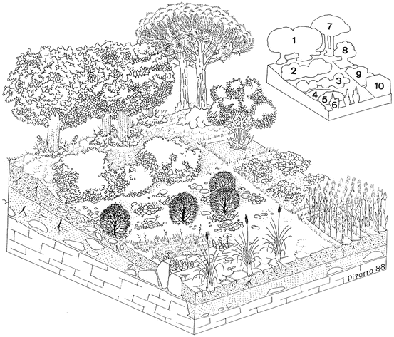
Mesomediterranean dry series of Quercus rotundifolia: Querco rotundifoliae sigmetum. (1) Quercetum rotundifoliae; (2) Rhamno lycioidis-Quercetum cocciferae; (3) Salvio lavandulifoliae-Ononidetum fruticosae; (4) Ruto angustifolii-Brachypodietum retusi; (5) Saxifrago tridactylitae-Hornungietum petraeae; (6) Agropyro pectinati-Lygeetum sparti; (7) Pinus pinaster plantation; (8) Olive grove; (9) Vineyard; (10) Cereal crop (After Loidi and Báscones 1995 with some alterations)
-
4.
Supramediterranean dry series of Quercus rotundifolia: Buxo sempervirentis-Querco rotundifoliae sigmetum
-
5.
Supra-mesomediterranean subhumid series of Quercus faginea: Violo willkommii-Querco fagineae sigmetum.
-
6.
Halophilous Aragonese inland geosigmetum
-
7.
Hygrophilous Aragonese riparian geosigmetum


The plant communities associated to each of these units are shown in Table 12.1.
10 Land Use
The Ebro Valley has a human population of less than three million inhabitants, a population density of below 35 persons/km2, quite low even for Iberian standards. Such a low figure is the result of the natural conditions of the territory, which determine a strong concentration of human activities in the alluvial plains due to irrigation agriculture. The modern industrial and post-industrial economy has caused rural abandonment and migration of the population to the big cities, leaving many villages and marginal districts practically deserted. From a historical perspective, human pressure has been intense in the Ebro Basin since antiquity. Archaeological sites of the Neolithic and Iron Age periods reveal a relatively dense human population and later, during the Roman Period, the territory experienced an intense demographic and socioeconomic development. Important cities were founded, such as Caesar Augusta (Saragossa), Osca (Huesca), Bilbilis (Calatayud), Calagurris (Calahorra), Ilerda (Lleida), etc. and an efficient network of roads were built to connect them (the North Via). During this period a substansive migration to the natural areas supposedly happened as the Roman society was organised in such a way that agrarian activities were oriented to supplying a broad market beyond merely a subsistence production. This required more land for cultivation, more wood for fire and for buildings, and more pastures for livestock, all of them demanded by a growing human population. Thus, large scale deforestation took place during this period. This was the beginning of a process which has resulted in a modern landscape that seems really devastated. The image of the Ebro Basin is really that of a semi-desert if it were not for a generous and dense network of large rivers that permits the life and prosperity of the human population.
During the Middle Ages the situation kept oscillating but from the 8th century onwards, the Ebro Basin was occupied by the Arabs for several hundreds of years (as other parts of the Iberian Peninsula) and they introduced new technologies and ways of exploiting the territory. Of particular relevance is the irrigation, which expanded dramatically in the Ebro Basin during their domination thanks to their construction of important hydraulic works. That heritage has resulted in the current importance of irrigation in many riverbank areas (called riberas, like the Ribera de Navarra) and the abundance of dams and channels currently present in the Ebro catchment area (224 altogether); most of which have been recently built to enlarge the irrigated area.
Concerning the restoration efforts to re-establish the vanished greenness of the landscape, the plantation of artificial forests using several tree species, mostly pines, can be mentioned. The species preferably selected in the Ebro Basin is Pinus halepensis, which is a natural species of the regional flora and this can be considered a convenient circumstance. Nevertheless, these plantations have yielded poor results due to the hard climate and the eroded soils.
References
Aguilella A, Riera J (1997) Estudios sobre la vegetación y flora halófilas de las saladas de ‘El Plano’ (Alcañiz-Calanda, Aragón, España). Publicaciones del Consejo de Protección de la Naturaleza de Aragón. Serie de Investigación, p 43
Báscones JC, Ursúa C (1986) Estudio fitosociológico de los pastos de la Ribera Tudelana. Príncipe de Viana Supl Ciencias 6:101–140
Báscones JC, Medrano LM, Ursúa C (2011) Yesos del distrito Bardenero y territorios aledaños. In: Mota JF, Sánchez-Gómez P, Guirado JS (eds) Diversidad vegetal de las yeseras ibéricas. El reto de los archipiélagos edáficos para la biología de la conservación. ADIF-Mediterráneo Asesores Consultores, Almería, pp 357–360
Belmonte MD, Laorga S (1987) Estudio de la flora y vegetación de los ecosistemas halófilos de la Rioja logroñesa (Logroño-España). Zubia 5:63–125
Berastegi A (2013) Prados y pastizales de Navarra: descripción, tipificación y ecología. Guineana 19:1–505
Biurrun I (1999) Flora y vegetación de los ríos y humedales de Navarra. Guineana 5:1–338
Blanché C, Molero J (1986) Las cubetas arreicas al sur de Bujaraloz. Contribución al estudio fitocenológico Lazaroa 9:277–299
Braun-Blanquet J, de Bolòs O (1958) Les groupements végétaux du bassin moyen de l’Ebre et leur dynamisme. Anales Estación Experimental Aula Dei 5(1–4):1–266
Conesa JA (1991) Comunitats vegetals de l’embassament d’Utxesa-Secà i rodalies, I: Comunitats aquàtiques, halòfiles, rupícoles, ruderals, nitro-halòfiles i arvenses. Ilerda (Ciències) 49:7–55
de Bolòs O (1961) La transición entre la Depresión del Ebro y los Pirineos en el aspecto geobotánico. Anales Inst Bot Cavanilles 18:199–254
de Bolòs O (1973) La vegetación de la Serreta Negra de Fraga. Mem Real Acad Ci Artes Barcelona 42(6):269–313
de Bolòs O (1996) Contribució al coneixement de la vegetació del territorio Auso-Segarric. Mem Real Acad Ci Artes Barcelona 55(4):2–272
Fernández-González F, Loidi J, Molina A (1986) Contribución al estudio de los matorrales aragoneses: los salviares riojano-estelleses. Anales Jard Bot Madrid 42(2):451–459
Fernández-González F, Molina A, Loidi J (1990) Los tarayales de la Depresión del Ebro. Acta Botanica Malacitana 15:311–322
Font X (2011) Yesos del anticlinal Barbastro-Balaguer a los Pirineos. In: Mota JF, Sánchez-Gómez P, Guirado JS (eds) Diversidad vegetal de las yeseras ibéricas. El reto de los archipiélagos edáficos para la biología de la conservación. ADIF-Mediterráneo Asesores Consultores, Almería, pp 367–372
Guardia R, Ninot JM (2000) Sobre la ecología de las comunidades gipsícolas en la comarca de la Noguera. Congreso de Botánica en homenaje a Francisco Loscos. Teruel, pp 797–809
Huguet del Villar E (1925) Avance geobotánico sobre la pretendida estepa central de España. Ibérica (Tortosa) 13 (576): 281–283; 13 (577): 297–302; 13 (579): 328–333; 13 (580): 344–350
Jäger EJ (1971) Die Pflanzengeographische Stellung der “Steppen” der Iberischen Halbinsel. Flora 160:217–256
Loidi J, Báscones JC (1995) Mapa de series de vegetación de Navarra. Memoria y mapa. Gobierno de Navarra, Pamplona, p 9
Loidi J, Fernández-González F (1994) The gypsophilous scrub communities of the Ebro Valley (Spain). Phytocoenologia 24:383–399
Loidi J, Biurrun I, Herrera M (1997) La vegetación del centro-septentrional de España. Itinera Geobotanica 9:161–618
Loidi J, Herrera M, Biurrun I, García-Mijangos I (1999) Relationships between syntaxonomy of Thero-Salicornietea and taxonomy of the genera Salicornia and Suaeda in the Iberian Peninsula. Folia Geobot 34:97–114
Longares LA (1997) El paisaje vegetal en el entorno de la reserva ornitológica ‘El Planerón’ (Belchite-Zaragoza). Consejo de Protección de la naturaleza de Aragón, p 193
Molero J, Vigo J (1981) Aportació al coneixement florístic i geobotànic de la Serra d’Aubenç. Treb Inst Bot Barcelona 6:82
Molero J, Sáez L, Villar L (1998) Interés florístico y geobotánico de la Sierra de Alcubierre (Monegros, Aragón). Acta Bot Barcinonensia 45:363–390
Molina A, Loidi J, Fernández-González F (1993) Sobre las comunidades de matorral de la Depresión del Ebro (España). Botanica Complutensis 18:11–50
Rivas Goday S, Borja J, Esteve F, Fernández-Galiano E, Rigual A, Rivas-Martínez S (1956) Aportaciones a la fitosociología hispánica (proyectos de comunidades hispánicas) Nota II (Comunidades gipsófilas fruticosas del centro y sudeste de España) Anales Inst. Bot Cavanilles 14:433–500
Rivas-Martínez S, Báscones JC, Díaz TE, Fernández-González F, Loidi J (1991) La vegetación del Pirineo occidental y Navarra. Itinera Gobotanica 5:5–456
Rivas-Martínez S, Pizarro J, Sánchez-Mata D (2000) Series de vegetación del valle medio del río Ebro. Congreso de Botánica en homenaje a Francisco Loscos. Teruel, pp 641–652
Terradas J (1986) El paisatge vegetal dels Monegros: assaig d’interpretació. Orsis 2:71–95
Ursúa C (1986) Flora y vegetación de la Ribera Tudelana. PhD Universidad de Navarra, Pamplona, p 640
Ursúa C, Bascones JC (2000) Vegetación de las lagunas endorréicas de Navarra. Congreso de Botánica en homenaje a Francisco Loscos. Teruel, pp 687–701
Villar L, Segarra-Moragues JG, Minaya MA, Pérez-Collazo E, Virual J, Catalán P (2011) El valle del Ebro (yesos monegrinos) y territorios colindantes. In: Mota JF, Sánchez-Gómez P, Guirado JS (eds) Diversidad vegetal de las yeseras ibéricas. El reto de los archipiélagos edáficos para la biología de la conservación. ADIF-Mediterráneo Asesores Consultores, Almería, pp 361–366
Willkomm M (1852) Strand- und Steppengebiete der Iberischen Halbinsel und deren Vegetation. Ein Beitrag zur physikalischen Geographie, Geognosie und Botanik. Friedrich Fleischer, Leipzig
Willkomm M (1896) Grundzüge der Pflanzenverbreitung auf der Iberischen Halbinsel. In: Engler A, Drude O (eds) Die Vegetation der Erde. Wilhelm Engelmann Verlag, Leipzig, p 395
Acknowledgments
I am grateful to my friend José Pizarro for his extraordinary drawings which illustrate this chapter. The funds of project IT299-10 for research groups of the Basque Government have supported this research.
Author information
Authors and Affiliations
Corresponding author
Editor information
Editors and Affiliations
Rights and permissions
Copyright information
© 2017 Springer International Publishing AG
About this chapter
Cite this chapter
Loidi, J. (2017). The Ebro Basin. In: Loidi, J. (eds) The Vegetation of the Iberian Peninsula. Plant and Vegetation, vol 12. Springer, Cham. https://doi.org/10.1007/978-3-319-54784-8_12
Download citation
DOI: https://doi.org/10.1007/978-3-319-54784-8_12
Published:
Publisher Name: Springer, Cham
Print ISBN: 978-3-319-54782-4
Online ISBN: 978-3-319-54784-8
eBook Packages: Biomedical and Life SciencesBiomedical and Life Sciences (R0)