
Abstract
The multifarious landforms making up the landscapes of Turkey are largely controlled by tectonic activity since the last 11 Ma, at most 23 Ma making surface correlation by elevation alone hazardous. This “neotectonic episode” is characterized by tectonic escape that created five neotectonic provinces in the country: (1) the shortening east Anatolian province corresponds to the eastern Anatolian highlands; (2) the gently E–W-shortening north Turkish province; (3) extensional west Anatolian province; (4) the gently NE–SW-shortening and NW–SE-extending Ova Province; and (5) the border folds (Assyrides) of the northernmost Arabian Plate. In each of these provinces, the rate and history of uplift, history of climate and rock types have dictated the details of land sculpture. Volcanic landforms dominate in the east, and karst dominates in the south. The other regions display more varied morphological types controlled mainly by rock type and climate. Although Turkey is moderately endowed in fossil glacial and periglacial forms, active glaciers are few and restricted to the high mountains in the extreme south-east of the country.
Access provided by Autonomous University of Puebla. Download chapter PDF
Keywords
1 Tectonic History and Resulting Tectonic Regions
The very high variety of Turkish geomorphological landscapes results mainly from the conjunction of (i) a complex geological structure and (ii) various impacts of tectonic activity and climate on the geomorphological evolution of different regions of the country. In this system, the structural context fixes the general frame, not only of the regional distribution of the geomorphological landscapes in Turkey, but also of its evolution through time and space (Fig. 3.1). The history of tectonic activity in Turkey is marked by a complete reorganization of relief during the Late Miocene, which separates a “palaeotectonic period” from a “neotectonic period”, two words which bear commonly, in the Turkish literature in the field of geology, a clear temporal meaning, since they were so defined by Şengör (1980): before and after the Late Miocene. Indeed, after the Late Miocene, complete rejuvenation of relief occurred, which has been of very high magnitude both in height and space displacements of formations and structures. This rejuvenation continued during the Pliocene and Quaternary and still continues in many regions, along lineaments and also localized spots throughout the country.

Geological map of Turkey. From the General Directorate of Mineral Research and Exploration (MTA)
1.1 Palaeozoic
The geological history of Turkey actually starts during the Archaean, but only a few zircon grains have been preserved from that remote era in the western Taurus Mountains (Kröner and Şengör 1989). Proterozoic events are more widely known (e.g. Ketin 1966; Kröner and Şengör 1989), but because of patchy preservation of respective rock series it has not yet been possible to generate a coherent history of this phase of evolution. Therefore, it is sensible to start the discussion on the geological history of Turkey with the Palaeozoic.
The Palaeozoic rocks form the basement in almost all parts of Turkey, except what has been called the Eastern Anatolian Accretionary Complex, which is much younger (Şengör and Yılmaz 1981; Şengör et al. 2008) (Fig. 3.2). In some areas, the Palaeozoic rocks have either not been metamorphosed or only very gently (up to lower greenschist grade) as in the İstanbul–Zonguldak Fragment, in parts of the Sakarya Continent and in the Taurus Mountains. In others, they have been gently to highly metamorphosed and even subjected to anatectic melting as in the Strandja, Menderes, Kırşehir, Alanya and Bitlis massifs and in parts of the Sakarya Continent as, for example, in the core of the Uludağ Massif. In the Pontides (i.e. a part of the larger Rhodope–Pontide Fragment; Şengör and Yılmaz 1981), they have not been either metamorphosed or metamorphosed and intruded by younger magmatic rocks. In the entire country, the Palaeozoic rocks have been gently to highly deformed during various tectonic (taphrogenic, keirogenic and orogenic) events.

Distribution of basement types and accretionary complexes in Turkey
1.2 Mesozoic and Palaeogene
The tectonic phase that initiated the structural frame of today’s relief of Turkey occurred during the Mesozoic and Cenozoic. It was dominated by subduction and collision events (Fig. 3.2). Initial subduction started in the Late Jurassic(?)–Early Cretaceous south of the Pontides (Şengör and Yılmaz 1981) (Fig. 3.3). During the Middle Cretaceous, another subduction zone commenced its activity between the Sakarya Continent and the Kırşehir Massif (Görür et al. 1984). Those subduction zones eliminated a part of the Neo-Tethys along the İzmir–Ankara–Ulukışla–Erzincan line, where many patches of the suture-related ultramafic volcanic rocks (ophiolites) crop out today (Fig. 3.4). The subduction ended with collisions during the Middle Eocene, that took place between the Pontides and the Sakarya Continent in the west and between the Pontides and the Kırşehir Massif in the east (Fig. 3.5). The shortening across Turkey that followed these collisions lasted into the Burdigalian west of the Eastern Anatolian Plateau, while it is still continuing today in the Eastern Anatolian Plateau and highlands (Fig. 3.6) and in the SE Turkish Border folds (Assyrides; Şengör et al. 1982).

Structural relationships between the Menderes–Taurus block (SW of Turkey) and the fragments of the Rhodope-Pontide/Sakarya–Palaeozoic continents (NW of Turkey). Cross section (A-A′) illustrates the fragments of the Rhodope-Pontide and Sakarya–Palaeozoic continent. Cross section (B-B′) illustrates the formation of the variously aged nappes originating from the Pontides over the Menderes–Taurus block

Photograph by C. Kuzucuoğlu, taken from the hills of the ancient capital of the Hittite Kingdom (Boğazkale = Hatuša) near Çorum in north-central Anatolia
Suture zone between the Sakarya Continent (at the right of the photograph) and the Central Anatolian Crystalline Complex (CACC) (in the background). Foreground: fragments of the Mesozoic ophiolite thrust formed during the collision of the Sakarya/Kırşehir collision. On the horizon: the denudational surface truncating the crystalline Kırşehir Massif and Mesozoic sediments. Other denudational surfaces truncate only Mesozoic series.

Photograph by A. Okay from Okay and Özgül (1984); (b) NE Nappes of the Antalya Plain (Upper Manavgat Valley). Original drawing by O. Monod
Two landscapes in the Middle Taurus region, featuring nappes originating from northern Turkey. (a) View of the Alanya Nappes (Alanya Massif, Middle Taurus), looking north.

Photographs by C. Kuzucuoğlu
Shortening thrusts resulting from Eocene collision (eastern Anatolian highlands). At Hoşap (Van), a half-washed earth brick wall by Urartu (eighth century BC) runs on the backbone of the thrusted units (Karasu River watershed, a tributary of Lake Van). b The eastern Anatolian contractional province (Lake Erçek Basin, Van).
In the meantime and also following the continental collision that occurred after the elimination of the Neo-Tethyan Ocean (Şengör and Yılmaz 1981), an extensive volcanic period ensued that followed an evolution through time from an areal type to more central stratovolcano types (Yılmaz et al. 1987). Regionally, these volcanic landscapes are concentrated in three sectors: western, central and eastern Anatolia.
1.3 Neogene and Quaternary: The Neotectonic Control
In the beginning of the Miocene (ca. 20 Ma ago), when western and central Turkey was still shortening, western Turkey had a probable height of 3000 m (a.s.l. of the time; Şengör 1991). By contrast, eastern Turkey was still under seawater until the Serravalian (Gelati 1975). During the Miocene, another collision phase started in SE Turkey, resulting from the Arabian Plate sliding north under the Anatolian plate. Eastern Turkey began rising, while western Turkey experienced extension and subsidence at the same time. This displacement provoked the westward escape of an Anatolian block from the east Anatolian convergent zone onto the oceanic lithosphere of the eastern Mediterranean Sea, mainly along the North and East Anatolian Fault Zones (NAFZ and EAFZ; Şengör et al. 1985) (Fig. 3.7). This rotational movement of the Arabian Plate continues today.

Western escape of the Anatolian Plate under the pressure of the collision caused by the sliding north of the Arabian Plate and the slab pull exerted by the Hellenic subduction (drawing modified from internet)
1.4 Five Tectonic Provinces of Turkey
According to Şengör (1980) and Şengör et al. (1985), these movements and related tectonic features, notably the North Anatolian Fault Zone (NAFZ) and East Anatolian Fault Zone (EAFZ), determine five neotectonic provinces in Turkey (Fig. 3.8). In Fig. 3.2, these units are drawn from the viewpoint of the Alpide evolution; i.e. they represent continental and arc fragments, accretionary complexes and sutures of the Neo-Tethyan Ocean. The five neotectonic provinces are:

-
(1)
The shortening east Anatolian province corresponds to the eastern Anatolian highlands that rise eastwards currently up to above 3000 and 4000 m high a.s.l. and form also the vast Eastern High Plateau, which head towards Iran (Fig. 3.6). Its average elevation is 2100 m. This province is mainly to the east of the junction point of the NAFZ and the EAFZ near Karlıova (the “Triple Junction”). Comprising the Lake Van Basin between the cities of Bingöl and Erzurum, it also corresponds to a mantle dome in Lake Van area (Şengör et al. 2008).
-
(2)
The gently E–W-shortening north Turkish province (mean altitude of 500–700 m at most, rising from west to east) is characterized by limited E–W shortening. A contemporary N–S shortening gave birth southwards to the northern part of the Pontide Range. Note that the common geographic name “Pontide Mountains” corresponds to the Turkish “Black Sea Mountains”. They correspond in part to an ancient tectonic unit north of the intra-Pontide/Erzincan Suture Zone (Fig. 3.2), which is in large part followed by the NAFZ, until the NAFZ reaches Bolu (Şengör et al. 2005). West of it, only the northern strand of the NAFZ follows the intra-Pontide Suture.
-
(3)
In the extensional west Anatolian province, N–S extension has caused the opening of rifts-orientated E–W towards the Aegean Sea (Fig. 3.9). Remnants of older structures are still partly preserved, in part because of the dissection of past reliefs (e.g. in the Menderes Metamorphic Massif). Before the Middle Miocene, the region was subjected to shortening that started during the Late Cretaceous. Afterwards, N–S extension caused the opening of E–W-trending rifts (e.g. Büyük Menderes and Küçük Menderes valleys) and NW–SE (e.g. Denizli and Soma) to NE–SW-directed relatively short cross-grabens (e.g. Gördes and Uşak–Güre basins) (Gürbüz et al. 2012). Controversial reconstructions propose three different time intervals for the development of these grabens: (i) during the Late Miocene (McKenzie 1972; Şengör and Yılmaz 1981; Şengör et al. 1985; Şengör 1987, 1991); (ii) during the Late Oligocene–Early Miocene, continuously evolving ever since (Seyitoğlu et al. 1992; Şen and Seyitoğlu 2009; Demircioğlu et al. 2010); and (iii) since the Plio-Quaternary (Erinç 1955; Yılmaz et al. 2000; Gürer et al. 2009; Bozkurt et al. 2011). At the same time as the rifting, local shoulder uplift occurred in the region (Erinç 1955; Şengör 1991; Bozkurt 2001; Westaway et al. 2004).
Fig. 3.9 
Geological map of western Turkey (after Bozkurt et al. 2011). This map illustrates the E–W graben structure of the Aegean region, organized as faulted uplifted and subsided blocks, also partly controlled by remains of old continents (e.g. the Menderes Massif) and the extension of the Taurus nappes. a Simplified geological map of Turkey showing the major metamorphic massifs and fault zones. BM—Bitlis Massif; CACC—Central Anatolian Crystalline Complex; PM—Pulur Massif. b Geological map of western Turkey showing the Menderes Massif and its subdivision. BG—Bakırçay Graben; DB—Demirci Basin; GB—Gördes Basin; GG—Gediz Graben; KG—Kütahya Graben; SB—Selenci Basin; SG—Simav Graben; BMG—Büyük Menderes Graben; CMM—Central Menderes Massif; KMG—Küçük Menderes Graben; NMM—Northern Menderes Massif; SMM—Southern Menderes Massif; UCB—Uşak–Güre Basin
-
(4)
According to Şengör (1980) and Şengör et al. (1985), the gently NE–SW-shortening and NW–SE-extending Ova Province includes two distinct geomorphological regions: (i) the western and central Taurus Range (Fig. 3.10) and (ii) the Central Anatolian Plateau (Fig. 3.11). At the junction of these regions, the Taurus comprises an Alpide basement fold in the sense of Argand (1924), which formed until the Burdigalian (the so-called “Courbure d’İsparta” or “İsparta Angle”: a concept introduced in Blumenthal 1963, p. 649; for the later literature, see Monod 1977; Poisson 1977; Şengör and Yılmaz 1981; Barka et al. 1995). In this area (the southern branch of the Neo-Tethys), both the Taurus Range and the Tauride belt consist of autochthonous units largely buried under nappes (Fig. 3.5), which partly have their roots in the İzmir–Ankara–Erzincan Suture zone in the north (Fig. 3.4). Accordingly, the highest Taurus nappes make the Menderes Massif a large tectonic window. This is also true in part for the Kırşehir Massif, although the nappes covering parts of it do not extend as far south as the Taurus. On both the Menderes and its easterly extension, as far as the Tuz Gölü Basin and on top of the Kırşehir Massif, Mio-Pliocene lacustrine and continental sediments form typical extensive plateaus and lake plains (Fig. 3.11) developed in central Anatolia. In these windows, remains of the Neo-Tethyan Suture Zone (especially ophiolites) crop out at many places (e.g. the surroundings of Çorum and Ankara) (Fig. 3.4). In its eastern parts, towards the Bitlis Suture Zone which is cut by the EAFZ and shortened by the Arabian Plate thrusting under Anatolia (Fig. 3.7), the altitudes of the plateau forming the heart of the Ova Province rise eastward (Fig. 3.12).
Fig. 3.10 
Photograph by M. A. Sarıkaya
High mountain landscapes of Mt. Bolkar in the central Taurus Range (Ulukışla, Niğde).
Fig. 3.11 
Photograph by C. Kuzucuoğlu
Salted landscapes in the central Anatolian “Ova” tectonic province (Tecer, Sivas). A series of closed depressions, partially connected through karstic underground circulations in gypsum bedrock, forms a line of fresh to saline shallow lakes.
Fig. 3.12 
Photograph by C. Kuzucuoğlu
Malatya plain, west of the EAFZ. The photograph illustrates the contact between the Central Anatolian Plateau tectonic province (left and background of the photograph) and the highlands of the eastern Anatolian contractional province (right and foreground of the photograph). The photographer turns her back to these latter highlands.
-
5.
The northern part of the Arabian Plate forms the south-east Anatolian lowlands (Fig. 3.13). The Eastern Anatolian Plateau being thrust over the northern part of the Arabian Plate, shortening movements created a series of border folds and thrusts, which form the “Assyrides” region of SE Turkey (Şengör et al. 1982) (Fig. 3.14).
Fig. 3.13 
Geological map of the south-eastern region of Turkey (after Okay 2008). This region corresponds to the northern part of the Arabian Plate, deformed by folds under the pressure of the Anatolian Plate thrust over the Arabian Plate
Fig. 3.14 
Photograph by C. Kuzucuoğlu, taken from the Deyrulzafaran Monastery
Landscapes in the Arabian Plate south of its tilted and folded northern parts (Mardin). The landscape illustrated here extends over Plio-Quaternary formations forming the Kızıltepe (Turkey) and north Syrian lowlands. The photograph is taken from the southern flanks of the Mardin anticline deforming Cretaceous to Eocene limestones and clastic sediments.


2 Tectonically Controlled Geomorphological Landscapes
During the Middle Miocene, the “neotectonic period” started in Turkey with differential movements across and along today’s Anatolian Peninsula. This “neotectonic period” is triggered and expressed by two aspects of tectonic dynamics (Şengör 1980; Şengör et al. 1985):
-
(1)
The collision of the Arabian continental fragment with Anatolia, triggering the westward expulsion of the Anatolian Plate along two important transform fault zones (NAFZ and EAFZ).
-
(2)
The general uplift of the peninsula, which caused differential elevation (triggering complex deformation of older erosional landscapes) between (i) the southern part of the peninsula (Taurus Range), which rose extremely fast to 3000 m, and the rest of the peninsula (e.g. Schildgen et al. 2014) and (ii) the western part of the peninsula which began subsiding, although small areas rose owing to footwall uplift of very large normal faults. By contrast, the east began ascending rapidly. This caused a general slope reversal of the earlier Miocene erosional landscapes westwards.
As a result of structural reorganization subsequent to this uplift and plate movements, the combination of structural changes with the activity of geomorphological agents and environmental systems produced, during the Pliocene and Pleistocene, a surprising variety of tectonically controlled landforms, landscapes and geomorphological features (Fig. 3.15).

Position of photographs in different chapters illustrating tectonically controlled landscapes. Faults and thrusts are compiled from several sources cited in text
2.1 Geomorphological Landscapes Responding to Uplift
The intense faulting and uplift that started ca. 20 Ma ago initiated a complete transformation of the relief in Anatolia (e.g. Yılmaz 2017 and references therein). During the Late Miocene, eastern Turkey rose out of the sea as it shortened, while western Turkey started stretching and subsiding. Therefore, during the Pliocene, the general geomorphological slope that had been eastwards until the beginning of the Miocene in the entire country switched to westwards. The morphological contrasts induced by this reversal caused the denudational processes to commence during the Early Miocene in the west when the land emerged from the Oligocene sea, and only during the Late Miocene in the east when eastern Anatolia started uplifting. Therefore, parts of the current morphology already began forming during the Palaeotectonic era in Turkey.
2.1.1 Remains of Palaeozoic and Pre-Miocene Reliefs
According to Şengör et al. (1985), during the mid-Miocene, the erosion phase continued in the west in the same way as during the Late Oligocene, in spite of the commencing collision in the south-east. For this reason, remains of Palaeozoic and pre-Miocene landscapes occur today mostly in north-western and western Anatolia, where they form isolated massifs composed of old metamorphic and crystalline rocks emerging from younger deposits of various ages and origins (e.g. the Strandja–Kocaeli mountains east and west of the Bosphorus; e.g. Şengör and Özgül 2010; Şengör 2011). In addition, Erol (1991) attributes an Oligocene age to parts of an erosion surface preserved in the transition zone between north-western and northern Anatolia on the one hand and Central Anatolian Plateau on the other hand (northern Neo-Tethyan Suture Zone) (Fig. 3.16). It must be noted that age attribution by Erol (1991) is based on the relative altitudinal position of a given surface within a staircase system. This interpretation proposes that the erosional stepped systems present in the Anatolian landscapes result from incision crises triggered by successive uplifts (and by high-magnitude climatic alternations during the Plio-Pleistocene). As a result, Erol (1991) considers that the uppermost surface is the oldest of all, and the lowest surface is the youngest of all, with a regular descent of age downslope for each consecutive erosional surface.

Photograph by C. Kuzucuoğlu
Mio-Pliocene denudational morphology over an uplifted block in the hinterland of the Aegean region (Simav Plain, Kütahya). The rectilinear edge of the mountain in the background is the fault scarp related to the active fault that forms the southern limit of the Simav plain (Simav, Kütahya).
2.1.2 Impact of the Mio-Pliocene Climate
Sediments recording erosion related to the formation of these Mio-Pliocene landscapes are found both over summit surfaces and on the slopes dominating lowlands associated with the denudational surfaces. Using facies differentiation of these sediments, Erol (1991) distinguishes two types of morphogenetic environments: (i) humid tropical during the Early to Middle Miocene, a period of relative tectonic stability, previous to the Late Miocene uplift, and (ii) semi-arid from the Late Miocene to the Pliocene. This semi-aridity of the climate during the “neotectonic” period in Turkey favoured the deposition of continental coarse-grained deposits, feeding wide piedmont areas at the foot of the rising mountains. These reddish continental deposits crop out very often in road sections or on fault scarps, as along the Aksaray Fault scarp in central Anatolia (Fig. 3.17). In central Anatolia, such deposits are characteristic of the environment that preceded or interrupted Miocene lacustrine or volcanic deposits. In the Aegean and the Mediterranean regions, they are also indicative of post-Miocene erosion during uplift.

Photograph by C. Kuzucuoğlu
The fault scarp line of the Aksaray Fault stimulates headward erosion of the Melendiz River (Aksaray), thus allowing outcrops of the thick reddish continental formation correlative to erosion of the Kırşehir Massif during the Early to Late Miocene (for location of the massif, see Fig. 3.2). The Upper Miocene Cappadocian ignimbrite flows overlie this formation. In the river bed some 5 km upstream the photograph, the formation covers uncomformably a metamorphic (marble) and granitic bedrock pertaining to the Kırşehir Massif.
2.1.3 Impact of Mio-Pliocene Uplift on Karstic Processes
During the Early Pliocene, the uplift of the area extending from central to eastern Anatolia was accompanied by abundant volcanism. This context created in the east an area that became higher than the former highlands that subsided in the west. In the meantime in western Anatolia, which had already been uplifted and eroded during the Late Miocene, local faulting was responsible for some additional footwall uplift, while the province as a whole was subsiding. As a result, in this region, old surfaces were preserved on top of the rising massifs. In areas where limestones older than the uplift were thick, karstic evolution started either before or during the Miocene. In addition to the desiccation and fossilization of these surfaces, rapid and high-magnitude incision of the landscapes by Plio-Quaternary rivers brought about the development of complex underground circulations associated with multiple storey cave systems (Erinç 1960b; Zwittkovits 1966; Şengör 1975; Eroskay and Günay 1979; Ekmekçi 2003).
2.1.4 Geomorphological Impact of Mio-Pliocene Volcanism on the Denudational Surfaces
From the Miocene to the Quaternary, volcanic emissions in central and eastern Anatolia have been abundant at places (Fig. 3.18) (Ketin 1961; Şengör and Dyer 1979). Ignimbritic deposits (e.g. in Cappadocia), complex volcanoes and/or basaltic flows (e.g. in the Kars area in eastern Anatolia) destroyed old continental landscapes on the one hand, also burying them on the other hand. For example, in Cappadocia, Aydar et al. (2013) and Lepetit et al. (2014) dated buried Mio-Pliocene surfaces using radioelements from both the ignimbrite flows and the formations correlative of the erosion phases. Besides, Sarıkaya et al. (2015) dated the surface exposures of the initial stage of fairy chimney landscape development and their erosion rates. In Cappadocia, Göz et al. (2014), and in south-eastern Anatolia Derman (1999), have shown that the study of such correlative sediments permits reconstructing Miocene to Pliocene geomorphological processes.

2.1.5 During Pliocene and Quaternary
Break-up of earlier erosional surfaces as well as regular destruction and transformation of landscapes continued everywhere in the peninsula and in eastern Turkey in relation to both tectonic activity and volcanism. Incision was particularly intense in the rising landscapes as in the northern Black Sea and the Taurus Ranges, as well as in the highlands of eastern Anatolia. At the same time and in comparison with the borders of the peninsula, in central Anatolia uplift was neither as high in magnitude (Çiner et al. 2015) nor so much accompanied by impressive fault systems. During this elevation, the plateau became disconnected from the outer piedmonts of the chains and became endorheic. The plateau, isolated from the seas, became covered by vast lakes. Lake occurrences and longevity were favoured by subsidence of tectono-karstic depressions. In the meantime, older series were buried entirely or partially, following the activity of Plio-Pleistocene structural deformations.
Today, remains of the pre-Late Miocene erosion surfaces form horizontal tracts of terrain truncating the tops of metamorphic, crystalline and older sedimentary and volcanic rocks in the transitional parts between the Central Anatolian Plateau westwards (e.g. the Menderes Massif in central western Anatolia) and eastwards (e.g. the Kırşehir Massif) (Fig. 3.2). In the inland parts of the Aegean and Mediterranean regions, dismantled remains of past topographies crop out both on top of the massifs and in the lowlands, where the material resulting from the destruction of the old topographies has accumulated (Erol 1986/1989). On top of the Taurus highlands, reconstructions of Miocene landscapes allow one to restore palaeogeographic connections (including networks of valleys orientated completely differently from the present one) (e.g. in the Taurus; Monod et al. 2006; Cosentino et al. 2012; Doğan et al. 2017). In the transition zones between central Anatolia towards east, north and west, geomorphological connections can be identified in landscapes that join (i) Mio-Pliocene bare erosion surfaces truncating old basement in the transition zones and (ii) Mio-Pliocene deposits on the slopes of these basement-cut surfaces recording erosion towards central Anatolia and river deposits inter-fingering with lake deposits (Erol 1991). In turn, in the central Anatolian landscapes, old pre-Miocene to Pliocene surfaces are exhumed from under younger sediments or as surfaces truncating the tops of rapidly uplifted surfaces, which during the Quaternary did not reach such altitudes as to be remodelled by Quaternary glaciers (Sarıkaya and Çiner 2015, 2017).
2.2 Antecedent and Superimposed River Courses
Since the Late Miocene, uplift has generated many occurrences of epigeny. Along the Aegean and Mediterranean shores, for example, the distribution of epigenic gorges resembles an inland belt line around Anatolia (Kayan 1999). This “borderline” results from the cumulative effect of uplift of the peninsula centre (triggering the proper epigeny) and variations in sea level. Both phenomena triggered also headward erosion of rivers. The geological and geomorphological contexts of the Turkish landscapes point to the persistence of the tectonic component during river incision in hard bedrock, with or without the presence of a possible cover. Consequently, it is often difficult to show in Turkey whether the genetic process was superimposition over a sediment cover above harder rocks or antecedence of the river/stream with regard to the uplift (Erinç 1953).
Superimposition is difficult to assess in Turkey mainly because the pre-uplift sediments fossilizing old erosion surfaces were eroded rapidly during the uplift phases. Erinç (1970) cites the examples of the Çoruh River in the surroundings of İspir (NE Anatolia) and of the Kızılırmak River between Bala and Kaman in central Anatolia. Other examples of superimposition are found along the Anatolian boundary thrust in south-eastern Anatolia, where parallel tributaries to the Euphrates have incised deep gorges in Eocene carbonates covered by Miocene clastics (Erinç 1953; Şengör and Kidd 1979). In the Aegean region, all rivers flow into coastal areas and the sea after having passed through gorges cut into hard rocks, a few tens of kilometres upstream the coast (Kraft et al. 1980; Kayan 2001). Above these gorges, post-Miocene continental sediments still occur above erosion surfaces preserved on top of the relief. Such is the case of the Esen River and of the Araplar Gorge of the Küçük Menderes between Ezine and Pınarbaşı. The age of the continental sediments burying these surfaces points clearly to a narrow and deep incision starting during the Pliocene. Therefore, the variations in the valley width at the epigeny location provoked accumulation of alluvium and the formation of river terraces upstream the gorges.
Antecedence cases are also very common in Turkey, because of the extreme youth and rapidity of uplift. Examples occur in the following places:
-
In the Marmara region, the terraces of the Garsak River, a tributary to Lake İznik east of the Marmara region, record a progressive incision through a dome-like tectonic feature (Erinç 1970).
-
In the Aegean inland, several examples of gorges interrupt strike-slip half-grabens along major block-forming faults.
-
In the Taurus as well as in the NE Black Sea Mountains, the main rivers are antecedent to the uplift. In the central Taurus, for example, 1000-m-deep canyons cross at right angles the hanged remnants of a now totally dried Miocene continental topography.
-
In central Anatolia, meanders of the Çarşamba River incise deeply into the Cretaceous limestone separating the Beyşehir and Konya Quaternary depressions. No Plio-Pleistocene sediments occur on the surface of the uplifted Cretaceous reliefs. The epigeny by antecedence thus points to the presence of a Mio-Pliocene river prior to the regional uplift (Fig. 3.19). In such situations, karstic processes have been active during uplift since the limestone bedrock favours the development of underground water circulation. In the case of Çarsamba River that was connecting today’s Lake Suğla polje drainage area to the Konya area, part of the Çarsamba gorge has dried up in the course of the epigeny. This phenomenon resembles the evolution of the mid-Miocene fossil valleys preserved on top of the Taurus Mountains (Monod et al. 2006). The sudden disappearance of water in the bottom of this gorge responded to a rapid infiltration at the base of the gorge, a karstic process triggered by high-magnitude uplift. Today, an artificial channel dug in the dry part of the gorge at the beginning of the twentieth century, has restored the continuity between Suğla and Konya plains through the Çarsamba Valley (Doğan and Koçyiğit 2018).
Fig. 3.19 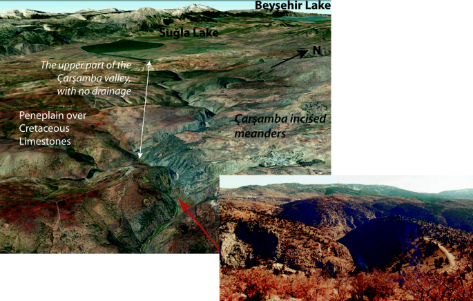
Photograph by C. Kuzucuoğlu
Dry gorge of the Çarşamba River, incising meanders into an erosion surface truncating Cretaceous limestones between the Konya Plain and the Suğla polje (Beyşehir, Konya). The upper part of this river used to flow from the Suğla polje into the Konya Plain. Because of uplift of the block separating the Suğla and Konya fault-controlled karstic depressions, the karstic network descended underground in the limestones forming the basement, and the meanders at the surface dried. Downstream the surficial drainage of the lower part of the Çarşamba River valley remained active because of water input from an important left bank tributary merging with the Çarşamba at a 45° angle.
-
In south-eastern Anatolia (see especially Şengör and Kidd 1979), deep meandering gorges of the Euphrates and the Tigris rivers cut into limestone folds of the Arabian Plate sedimentary cover. As a result of uplift and karstic evolution of the substratum, hanging valleys and hanging lakes are quite common in the whole eastern Taurus Range. In the upper drainage basin of the Tigris River, Plio-Pleistocene sediments date to the end of the Pliocene or beginning of the Pleistocene the antecedence of river incision into older fossil karstic landscapes. In the southern part of the EAFZ, Erinç (1970) documented also the antecedence of the Kısık gorge incised by the Ceyhan River through the Berit and Engizek mountains in southern Turkey.

2.3 Uplift and Control on Karstic Landscapes
Tectonic control over karstic areas is responsible for a high variety of landscapes in all limestone regions of Turkey where it favours, both the enclosure of depressions and captures of rivers on the surface, and in the underground the formation of stepped karstic systems triggering fossilization of surface morphology (Şengör 1975; Ekmekçi 2003). The most important geomorphological features and landscapes associated with the tectonic control over karstic systems are:
-
i.
The development of partly tectonically controlled karstic depressions, often occupied by lakes in the Central Anatolian Plateau. All plains forming the Lake District, as well as the closed depressions of Konya, Tuz Gölü and Sultansazlığı in Cappadocia, belong to these landscapes. Similarly, smaller landscapes like poljes are quite common, not only in central Anatolia but even more in the Aegean, Mediterranean and eastern regions, where several flat-bottomed depressions hollowing the mountain ranges have formed (Penck 1918, pp. 105–106; Alagöz 1944; Louis 1956; Erinç 1960a, b; Şengör 1975; Ekmekçi 2003; Doğan et al. 2017).
-
ii.
Stepped cave systems and underground networks forming several storey edifices in thick limestone series, especially in the Taurus, from its western to eastern extremities. Karstic systems descend while landscapes rise, generating fossil networks at higher altitudes. At the uppermost level, i.e. on the surface of the uplifted reliefs, large dry valleys inherited from older periods (Miocene or Early Pliocene) occur when warm and humid climates favoured the rapid weathering of limestone accompanying lateral development of drainage. Such valleys can usually be dated to the Miocene in the western Taurus and to the Pliocene in the eastern Taurus. In all cases, such landscapes are associated with hanging dry valleys, also preserved at higher latitudes because of uplift. In the case of the valleys to the north of Manavgat, uplift caused hanging of dry Miocene valleys ca. 1000 m above Plio-Pleistocene canyons (Monod et al. 2006).
-
iii.
At places, uplift has been so rapid that it has generated rivers disappearing (through sinkholes) below and resurging (through karstic springs) at opposite feet of ridges. Such cases occur in the western Taurus in relation to uplifted limestone massifs (e.g. Lake Beyşehir, Akdağ Massif). They also occur in the folded parts of south-eastern Anatolia, where underground karstic drains secure the continuity of river flow from one flank of anticlines to the other. Such a subterranean drainage system running through parallel folds is also visible in the Ergani area in the south-eastern Anatolian highlands (Fig. 3.20).
Fig. 3.20 
Drawing: C. Kuzucuoğlu, with a Google Earth background image
Karstic swallow holes and springs at each side of anticlines forming elongated mounds west of the Ergani Plain (Ergani, Diyarbakır). The map illustrates both the descent and the changes in directions of a river network, today dismantled because some parts of it, previously superficial, have become underground through the anticlines as these were upfolding. 1. Anticline axis; 2. Mound corresponding to anticline; 3. Palaeo network (dry valley preserved on the summit of fold); 4. Superficial stream; 5. Cluse (i.e. a valley misfit to structure); 6. Swallow hole; 7. Karstic spring; 8. Wetland developed on the sediment fill of a syncline; and 9. Urban area.
-
iv.
In the Taurus, where limestone series are the thickest in Turkey, some mountainous landscapes seem to be formed exclusively of widely expanding deep lapiez surfaces keeping away wanderers (e.g. the “Geçitvermez” Mountain—the “mountain that cannot be crossed”—on top of the fault scarp overlooking the Suğla Plain in the central Taurus), as already noted by some Byzantine historians: “… the Taurus, which is very steep and craggy, difficult to cross and rugged, and capable of dispersing an army so that it could not be reassembled, and of destroying the hoofs of the horses” (Michael Attaliates, History, XVIII.16).

3 Geomorphological Landscapes Directed by Tectonic Networks
The five structural provinces of Anatolia (Fig. 3.8) are still active today, with rising highlands, subsiding basins, fault-controlled depressions and valleys, river incisions and stepped karstic slopes. The combination of the impacts of tectonics with the action of other geomorphological agents and environmental systems during the Pliocene and Pleistocene has produced a surprising variety of tectonic landforms, landscapes and geomorphological features. This variety owes also to local and regional geographic contexts as well as to changes in the acting processes of morphogenetic factors in relation to lithology (e.g. karstic processes; Öztürk et al. 2018), climate, sea-level changes and uses of natural resources by man during a few thousands of years (e.g. water control practices such as irrigation and dams, which are in use in Turkey since the 2nd mill. BC).
3.1 Depressions and Lakes Along the North and East Anatolian Fault Zones
3.1.1 The NAFZ and EAFZ: Active Fault Zones
The 1600-km-long dextral strike-slip North Anatolian Fault Zone (NAFZ) runs along the transform boundary between the Eurasian and Anatolian plates (Stein et al. 1997; Şengör et al. 2005). The NAFZ formed ca. 13–11 Ma ago in the east and reached the Sea of Marmara not earlier than 200 ka ago. Since the Late Pleistocene, it has been running only about 20 km south of İstanbul (the closest it comes to İstanbul is 8 km south of Yeşilköy, the old San Stefano) and now extends into the Aegean Sea after developing below the Marmara Sea (Faridfathi and Ergin 2012; Vardar et al. 2014; Le Pichon et al. 2016). Since the seventeenth century at least, it has shown cyclical seismic behaviour, with century-long cycles beginning in the east and progressing westwards (Şengör et al. 2005). Recent studies of the twentieth-century seismic record show that earthquakes concentrate their displacement at the western tips of its 19 broken segments (Fig. 3.21). After the last events, which occurred on 17 August and 12 November 1999 on the Adapazarı–İzmit segment, the activity of the NAFZ is considered to be one of the most dangerous natural hazards in Turkey.

Progressive failure of the North Anatolian Fault during the twentieth-century earthquake cycle by stress concentration at the tips of failed segments. Red regions are where the stresses are high representing likely places where the next break will take place. Courtesy of Ross Stein and Serkan Bozkurt
The left lateral strike-slip Eastern Anatolian Fault Zone (EAFZ) forms the tectonic boundary between the Anatolian block or Scholle and the north-westward moving Arabian Plate. North-westwards, it cuts at a very acute angle the thrust boundary of the old Anatolian basement bordered by the Bitlis Suture Zone, and southwards, it follows the limit of the tilted Cenozoic marine cover of the Arabian Plate thrust under the Anatolian Plate. At its SE extremity near Kahramanmaraş, the EAFZ joins the Dead Sea Transform Fault Zone (Fig. 3.7) at a triple junction (Şengör et al. 1985). During the last decade, the EAFZ has been responsible for a series of important earthquakes at Bingöl and Elazığ, although the Bitlis–Zagros Suture Zone (along which the Arabian Plate converges towards the Anatolian Plate) seems to be currently not as active (Bulut et al. 2012). However, after the manuscript of this paper was completed, a magnitude 7.3 thrust fault earthquake hits the Zagros south of Halabjah in Iraq near the Iranian border on 12 November 2017 at 18:18 GMT killing at least 530 people and injuring several thousands. Its hypocentre was at a depth of 19 km according to the USGS. Earthquakes larger than M = 6 also occur (e.g. the M = 6.7 1976 Lice earthquake) (Şengör et al. 1985). In the early 2007, a series of M > 5 events occurred in the Sivrice segment, followed in 2010 by M = 6.0 in Elazığ (Bulut et al. 2012). This deceleration of the northward push of the Arabian Plate is in step with the acceleration of the westward movement of Anatolia (from 6.5 mm/yr during the last 13 Ma to 18–25 mm/yr) (Hubert-Ferrari et al. 2002; Muller and Aydın 2004). As in the case of the NAFZ, active seismicity along the EAFZ concerns a band with a width of roughly 20 km along the NE–SW path of the EAFZ. The band is clustered in distinct segments that are sub-parallel to the EAFZ trend and are typically ca. 30 km long (Bulut et al. 2012) (Fig. 3.22). Several smaller sub-segments are, however, orientated N–S and E–W. The main segments are Bingöl, Palu, Sivrice and Kahramanmaraş. Among the segments of the EAFZ, the segments forming the Pütürge–Elazığ Basin (central part of the EAFZ lineament) have hosted the highest seismicity rate for the 2007–2010 time period (Bulut et al. 2012). It is worth noticing that the geomorphological records around Lake Hazar (as well as the sediment filling of the lake; Eriş 2013) show the episodically active movement of the Sivrice segment of this Pütürge–Elazığ Basin. Besides, in places along the segments, landscapes on both sides of the EAFZ are remarkably contrasting, reflecting the juxtaposition of completely different bedrock (e.g. at Palu; Fig. 3.23).

Segments of the Eastern Anatolian Fault between Gölbaşı (Adıyaman) and Bingöl. 1. Lake dam; 2. Natural lake; 3. Natural wetlands (tectonic basin); 4. Natural wetlands not completely submerged by lake dam; 5. Concentration of earthquakes during the 2002–2007 period; 6. Active segment of the EAFZ; 7. Dead Sea Fault Zone; 8. Faults of the EAFZ; 9. North Anatolian Fault; 10. Meeting points of the EAFZ with the Dead Sea transform fault zone (south) and the NAFZ (north); 11. Suture line between the Arabian Plate thrusted over the Anatolian Plate; and 12. Dam. Redrawn, modified and completed from Bulut et al. (2012) on a Google Earth background image and checked with 1:25.000 topographic maps

Photograph by C. Kuzucuoğlu
Palu segment on the EAFZ (Palu, Elazığ). The left lateral strike-slip eastern fault juxtaposes two distinct landscapes at Palu: the metamorphic Bitlis Suture Zone (left of the picture) and the Cenozoic marine to lake carbonate series (right of the picture). The Euphrates River flows toward the south-east, following the EAFZ faulted contact.
3.1.2 Structural Intramontane Basins Along the NAFZ and the EAFZ
Along the path of the NAFZ, elongated strike-slip basins started to form following the Miocene collision. Subsidence in these basins has triggered continuous accumulation during the Pleistocene and Holocene, often in lake environments that are in places still present today (see Şengör et al. 2005 for a summary). Several of these basins have delivered high-resolution records of Upper Pleistocene and Holocene vegetation history based on pollen assemblages (Bottema et al. 1993/1994; Nazik et al. 2011; Ülgen et al. 2012; Beug and Bottema 2015). Also, a variety of researches have concentrated on past climates (Yaltırak et al. 2012). Along the EAFZ path, similar Quaternary sedimentary sequences are rare because of the less frequent opening of strike-slip basins. A few palaeoenvironmental and palaeoclimatic researches have been performed in the Lake Hazar (Eriş et al. 2016), in the Gölbaşı area and in the Antakya Plain (the Lake Amuk plain that marks the junction of the Dead Sea rift system and the EAFZ; Bridgland et al. 2012).
After the 1999 earthquake at Yalova near İstanbul, the NAFZ has been subject to a large number of researches about its activity and functioning. Some of them concerned the sediment dynamics within the basins (e.g. Roeser et al. 2012; Ülgen et al. 2012; Viehberg et al. 2012; Yaltırak et al. 2012) and in the river valleys affected by faulted structures (Kıyak and Erturaç 2008; Erturaç and Tüysüz 2012). Most of them concerned river paths and escarpment morphologies resulting from the strike-slip movements of the faults (triangular facets, diversion of streams, displacement of blocks, disconnected morphologies along faults, etc.). These studies succeeded mostly in defining and measuring the physical impacts of the faulted system on the landscapes (uplift, displacements, captures, incisions) (e.g. Gürbüz and Gürer 2008; Erturaç and Tüysüz 2012; Sarp et al. 2014; Selim 2013; Tarı and Tüysüz 2016).
Along the EAFZ path, fault-controlled landscapes also comprise elongated depressions occupied by wetlands, which correspond to the subsiding parts of segments of the fault zone. While lakes or marshes occupy some of them, major rivers, especially the head tributaries or main trunks of the Seyhan and the Euphrates rivers, drain others. Flanks of ruptured reliefs as well as fluvial landforms record both the morphological and the sedimentological impacts of the activity of the segments. Today, several of these wet depressions are filled with dam lake reservoirs. In the central part of the EAFZ, the largest strike-slip faulted basin (Pütürge–Sivrice–Elazığ basin) hosts the Lake Hazar (20 km long, 212 m deep and 4 km wide), dated to approximately 148–178 ka (Çetin et al. 2003; Aksoy et al. 2007). Around and in the faulted basins, several morphotectonic features record both uplift (deformed lake terraces) and strike-slip fault-controlled parallel escarpments and triangular slopes.
3.2 River Paths, Captures and Mobility of Water Divides
The activity of faults favours not only the presence of lakes, but also the diversion and versatility of past outlets of lakes (e.g. the spring of the head-tributaries of the Tigris River; the drainage network deformation along the NAFZ near Gerede; Erinç et al. 1961).
3.2.1 Changes in Base Levels and Headward Erosion
In Turkey, changes of base level in river networks occurred because of (i) relief discontinuities produced by vertical tectonic movements (uplift/subsidence and faulting) or (ii) hydraulic connections occurring either upstream, when backward erosion reaches upper isolated plains, or downstream, when sea level decreases or increases, for example as during the Messinian salinity crisis of the Mediterranean followed by the post-Messinian sedimentary fills observed in the Antalya and Adana basins (Görür 1982; Öğrünç et al. 2000; Çiner et al. 2008; Cosentino et al. 2012; Schildgen et al. 2012, 2014). Görür (1982) in particular emphasized the importance of the Messinian crisis on the petroleum potential of these basins. Later, during the Quaternary, additional sea-level changes were also triggered by changes in global climate due to glacial/inter-glacial intervals in the Mediterranean (Hughes and Woodward 2017), in the Bosphorus (Şengör 2011) and in the Black Sea (Ryan et al. 1997).
All these processes redistribute watersheds. In Anatolia, examples are numerous for each of these processes (river flow disconnections vs. connections), whether on the surface or underground. Examples of fault disruption-induced changes in watersheds are more frequent in eastern Anatolia, while examples of headward erosion due to uplift of headwater areas or to sea-level decrease are more frequent in the Black Sea (e.g. Kızılırmak River; Berndt et al. 2017), Aegean (e.g. Büyük Menderes River; Kazancı et al. 2011; Gürbüz et al. 2012) and Mediterranean regions (e.g. Aksu and Göksu rivers). These examples are characteristic of the impact of differential uplift, which has caused repeated river captures in the regions surrounding the Central Anatolian Plateau, at the expense of the endorheic parts of the plateau.
3.2.2 River Network in Young Tectonic Context
River-capturing processes, still quite common in the dynamic tectonic environment of Turkey, are also under the control of major faults. Those who ever worked on drawing watershed divides in mountainous areas of Turkey (whether using Internet resources or any map at any scale) have been confronted with confusing relationships between relief volumes and river paths. This puzzling situation arises from alignments of straight river courses, which are separated by subtle watershed thresholds or by small to large closed depressions whose connections with hydrologic networks remain far from clear. This highly unusual distribution of river watersheds reflects differences in the adaptation rhythms of river incision in Anatolia to the high speed of the recent rise of relief. The more recent is the uplift, and the more confusing is the organization of the river network. Whether tectonic movements produce faulting or uplift/subsidence, the timing, path and intensity of river incision also respond differently. Such examples of fault control are strikingly numerous along the NAFZ and, especially, along the EAFZ, as well as along faults limiting grabens collecting and directing watercourses in dismantled mountain regions (Şengör 2017).
3.2.3 Fault-Controlled River Paths
Rectilinear courses of narrow–short and wide–long valleys meeting at right angles are common features on any map illustrating river paths in Turkey. This is especially true along the NAFZ and the EAFZ. When crossing sub-active or active faults with a high lateral component, river paths follow typical side-sliding courses parallel to that of strike-slip faulting. Such side-sliding displacements are currently observed and measured along the NAFZ (e.g. Gürbüz et al. 2015; Tarı and Tüysüz 2016; Şengör 2017). Along the EAFZ, angular zigzag paths are particularly spectacular in the upper basins of (i) the Seyhan River when it gets close to the Euphrates basin upstream the Kahramanmaraş city area, (ii) the Euphrates and right bank tributaries upstream the Adıyaman Basin, (iii) the valleys of both upper members of the Euphrates when they cross the EAFZ (Murat River) and the NAFZ (Karasu River) and (iv) the Tigris River between Lake Hazar and Ergani city (Fig. 3.24). In karstic areas where processes develop a complex underground network, the effects of these processes combine with the surface linear displacement of valleys to produce specific spots where water divides are disputed by oppositely flowing systems (e.g. the Gölbaşı case, between Seyhan and Euphrates basins; Fig. 3.24).

Drawn from reporting 10 m contours on 1:25,000-scaled topographic maps
River captures in the Upper Euphrates and Upper Tigris basins along the EAFZ: 1. Dam lakes; 2. Natural lakes; 3. Wetlands (flat closed depressions); 4. Rivers merging at right angle; 5. Areas treated by capture; 6. Tributary rivers; 7. Main rivers; 8. Rivers and streams in the Gölbaşı closed depression; 9. Dams; 10. EAF–NAF meeting point at Karlıova.
4 Conclusion
The neotectonic interval in Turkey, i.e. the last 11–13 Ma, has seen not only a great amount of activity, but also a tremendous variety of it. In this sense, too, Turkey is really a “Minor Asia” containing at least five tectonic provinces of contrasting structures and evolutionary histories. That activity is continuing as reflected by the active seismicity of the country. The Aegean region, for instance, is one of the seismically most active continental regions in the world. There have been no well-documented volcanic eruptions since 1443, but some of the large eastern Anatolian volcanoes such as Nemrut and Tendürek may erupt at any time and cause devastation around them. The seas around Turkey (Black Sea, Aegean Sea and Mediterranean Sea) and within it (Sea of Marmara) have undergone extremely complex histories tied to both waxing and waning continental glaciers in Eurasia, but also to fluctuating worldwide sea level. Both the Black Sea and the Mediterranean Sea have been closed seas during parts of their histories having truly dramatic episodes such as the Messinian Salinity Crisis that impacted not only the coastal regions of Turkey, but also the entire country, including the endorheic central regions via their climatic effects. Vast lakes once occupied areas that are now semi-deserts in these internal regions. Forward climate modelling studies show that the aridification trend continues (except along the northern geomorphic region) and once-fixed sand dunes in central Anatolia have in places resumed their movements. Aridification, combined with ill-informed water usage, has affected karstic regions and accelerated the formation of karst pits (“obruks”) in south-central Turkey. Geomorphological studies have entered a very exciting phase in Turkey, particularly since the introduction of refined surface-dating techniques, GPS and very high-resolution satellite imaging. We hope that the chapters in this book will prove springing boards for sophisticated future studies of this very interesting part of our planet.
References
Aksoy E, İnceöz M, Koçyiğit A (2007) Lake Hazar Basin: a negative flower structure on the east Anatolian Fault System (EAFS), SE Turkey. Turk J Earth Sci 16:319–338
Alagöz CA (1944) Türkiye Karst Olayları. Türk Coğrafya Kurumu Yayınları 1, Ankara
Argand E (1924) La tectonique de l’Asie: Congrés Géologiques International, Compte-Rendus de la XIIme session, Premier Fascicule. H. Vaillant-Carmanne, Liège, pp 171–372
Aydar E, Çubukçu E, Şen E, Akın L (2013) Central Anatolian plateau, Turkey: incision and paleoaltimetry recorded from volcanic rocks. Turk J Earth Sci 22:739–746
Barka A, Teilinger R, Şaroğlu F, Şengör AMC (1995) The Isparta angle: its importance in the neotectonics of the Eastern Mediterranean region. In: Pişkin Ö, Ergün M, Savaşçın Y, Tarcan G (eds) Proceedings of the international earth sciences colloquium on the Aegean region (IESCA-95), İzmir 1:3–17
Berndt C, Yıldırım C, Çiner A, Ertunç G, Sarıkaya MA, Özcan O, Kıyak NG, Öztürk T (2017) Timing and development of Late Quaternary fluvial terraces of the lower course of Kızılırmak River (Northern Turkey). EGU General Assembly, Vienna, Geophysical Research Abstracts, Vienna, 19, EGU2017-1173
Beug HK, Bottema S (2015) Late Glacial and Holocene vegetation history at Lake Yeniçağa, northern Turkey. Veg, Hist Archaeobot 24:293–301
Blumenthal MM (1963) Le système structural du Taurus sud-Anatolien. In: Durand-Delga M (ed) Livre à la Mémoire du Professeur Paul Fallot, consacré à l’évolution paléogéographique et structurale des domaines méditerranéens et alpins d’Europe. Mémoire hors-série de Société Géologique de France, Paris, pp 611–662
Bottema S, Woldring H, Aytuğ B (1993/1994) Late Quaternary vegetation history of northern Turkey. Palaeohistoria 35/36:13–72
Bozkurt E (2001) Neotectonics of Turkey-A synthesis. Geodinamica Acta 14:3–30
Bozkurt E, Satır M, Buğdaycıoğlu Ç (2011) Surprisingly young Rb/Sr ages from the Simav extensional detachment fault zone, northern Menderes Massif, Turkey. J Geodyn 52:406–431
Bridgland DR, Westaway R, Abou Romieh M, Candy I, Daoud M, Demir T, Galiatsatos N, Schereve DC, Seyrek A, Shaw AD, White TS, Whittaker J (2012) The river Orontes in Syria and Turkey: downstream variation of fluvial archives in different crustal blocks. Geomorphol 165–166:25–49
Bulut F, Bohnhoff M, Eken T, Janssen C, Kılıç T, Dresen G (2012) The east Anatolian fault zone: seismotectonic setting and spatiotemporal characteristics of seismicity based on precise earthquake locations. J Geophys Res 117(B7). https://doi.org/10.1029/2011jb008966
Çetin H, Güneyli H, Mayer L (2003) Paleoseismology of the Palu-Lake Hazar segment of the east Anatolian fault zone, Turkey. Tectonophys 374(3–4):163–197
Çiner A, Karabıyıkoğlu M, Monod O, Deynoux M, Tuzcu S (2008) Late Cenozoic sedimentary evolution of the Antalya Basin, southern Turkey. Turk J Earth Sci 17:1–41
Çiner A, Doğan U, Yıldırım C, Akçar N, Ivy-Ochs S, Alfimov V, Kubik PW, Schlüchter C (2015) Quaternary uplift rates of the Central Anatolian Plateau, Turkey: insights from cosmogenic isochron-burial nuclide dating of the Kızılırmak River terraces. Quatern Sci Rev 107:81–97. https://doi.org/10.1016/j.quascirev.2014.10.007
Cosentino D, Schildgen TF, Cipollari P, Faranda C, Gliozzi E, Hudáčková N, Lucifora S, Strecker MR (2012) Late Miocene surface uplift of the southern margin of the Central Anatolian plateau, Central Taurides, Turkey. Geol Soc Am Bull 124:133–145
Demircioğlu D, Ecevitoğlu B, Seyitoğlu G (2010) Evidence of a rolling hinge mechanism in the seismic records of the hydrocarbon-bearing Alaşehir Graben, western Turkey. Pet Geosci 16:155–160
Derman AS (1999) Braided river deposits related to progressive Miocene surface uplift in Kahraman Maraş area, SE Turkey. Geol J 34 (Special issue: advances in Turkish geology, Part I) 1–2:159–174
Dhont D, Chorowicz J, Yürür T, Froger J-L, Köse O, Gündoğdu N (1998) Emplacement of volcanic vents and geodynamics of Central Anatolia. Turkey J Volc Geoth Res 85:33–54
Doğan U, Koçyiğit A, Gökkaya E (2017) Development of the Kembos and Eynif structural poljes: Morphotectonic evolution of the upper Manavgat River basin, central Taurides, Turkey. Geomorphol 278:105–120. https://doi.org/10.1016/j.geomorph.2016.10.030
Doğan U, Koçyiğit A (2018) Morphotectonic evolution of Maviboğaz canyon and Suğla polje, SW Central Anatolia, Turkey. Geomorphol 306:13–27. https://doi.org/10.1016/j.geomorph.2018.01.001
Ekmekçi M (2003) Review of Turkish karst with emphasis on tectonic and paleogeographic controls. Acta Carsologica 32:2
Erinç S (1953) Doğu Anadolu Coğrafyası. İstanbul Üniversitesi Yayınları No: 572, Edebiyat Fakültesi Coğrafya Enstitüsü Yayınları No: 15, İstanbul, 124 p
Erinç S (1955) Die morphologischen Entwicklungsstadien der Küçükmenderes-Masse. Review of the geographical Institute of the University of İstanbul 2:93–96
Erinç S (1960a) Konya bölümünde ve iç Toros sıralarında karst şekilleri üzerinde müşahadeler. Türk Coğrafya Dergisi 20:83–106
Erinç S (1960b) On the karst features in Turkey. Rev Geogr Inst Univ Istanb 6:1–14
Erinç S (1970) Contribution of geomorphology to the Quaternary of Turkey. Jeomorfol Derg 2(2):12–35 (with a full up-to-1970 reference list of Turkish/International published researches concerning geomorphology in Turkey) (in Turkish)
Erinç S, Bilgin T, Bener M (1961) Gerede civarında akarsu şebekesi Revier drainage in the Gerede area). Review of the geographical Institute of the University of İstanbul 6:90–99 (in Turkish)
Eriş KK (2013) Late Pleistocene-holocene sedimentary records of climate and lake-level changes in Lake Hazar, eastern Anatolia, Turkey. Quaternary International:123–134
Eriş KK, Akçer S, Cağatay N, Aslan TN, Damcı E, Ülgen UB (2016) Deciphering paleoclimatic responses for the evolution of Late Pleistocene to Holocene sedimentary records of Lake Hazar, eastern Anatolia, Turkey. Geophysical research abstracts 18, EGU2016-1674-1
Erol O (1986/1989). Türkiye’nin Jeomorfolojik Evrimi ve Bugünkü Genel Jeomorfolojik Görünümü. Türkiye Jeomorfolojisi. (The geomorphologic history of Turkey and aspects of its present evolution: a compilation of O. Erol’s lessons on the Geomorphology of Turkey). Available at doguates2000@yahoo.com (in Turkish)
Erol O (1991) Geomorphological evolution of the Taurus mountains, Turkey. Zeitschr. für Geomorphologie N.F. Supp. Bd. 82:99–109
Eroskay SO, Günay G (1979) Tecto-genetic classification and hydrogeological properties of the Karst regions in Turkey. In: International seminar on Karst hydrogeology. Oymapınar, Antalya, Turkey, pp 1–41, 9–19 Oct 1979
Erturaç K, Tüysüz O (2012) Kinematics and Basin formation along the Ezinepazar-Sungurlu fault zone, NE Anatolia, Turkey. Turk J Earth Sci 21(4):497–520
Faridfathi FY, Ergin M (2012) Holocene sedimentation in the tectonically active Tekirdağ Basin, western Marmara Sea, Turkey. Quatern Int 261:75–90
Gelati R (1975) Miocene marine sequence from Lake Van, eastern Turkey. Riv Ital Paleont Stratigr 81:477–490
Görür N (1982) Adana Havzası’nın petrol potansiyelinin değerlendirilmesinde yeni bir görüş (A new insight to the oil potential evaluation of the Adana Basin). In: Güven A, Dinçer A, Derman AS (eds), Proceedings of the 6th Congress of Geology in Turkey, pp 73–79
Görür N, Oktay FY, Seymen İ, Şengör AMC (1984) Palaeotectonic evolution of the Tuzgölü Basin complex, Central Turkey: sedimentary record of a Neo-Tethyan closure. In: Dixon JE, Robertson AHF (eds) Geological evolution of the Eastern Mediterranean. Geol. Soc. London Spec. Pub. 17, pp 467–482
Göz E, Kadiri S, Gürel A, Eren M (2014) Geology, mineralogy, geochemistry, and depositional environment of a Late Miocene/Pliocene fluviolacustrine succession, Cappadocian volcanic province, Central Anatolia, Turkey. Turk J Earth Sci 23:386–411
Gürbüz A, Boyraz S, Ismael MT (2012) Plio-quaternary development of the Baklan-Dinar graben: implications for cross-graben formation in SW Turkey. Int Geol Rev 54(1):33–50
Gürbüz A, Gürer ÖF (2008) Tectonic geomorphology of the north Anatolian fault zone in the Lake Sapanca Basin (Eastern Marmara Region, Turkey). Geosci J 12(3):215–225
Gürbüz E, Kazancı N, Gürbüz A (2015) Strike-slip faulting, topographic growth and block movements as deduced from drainage anomalies: the Yeşilırmak River Basin, northern Turkey. Geomorphol 246:634–648
Gürer ÖF, Sarıca-Filoreau N, Özburan M, Sanğu E, Doğan B (2009) Progressive development of the Büyük Menderes Graben based on new data, western Turkey. Geol Mag 146(5):652–673
Hubert-Ferrari A, Armijo R, King GCP, Meyer B, Barka A (2002) Morphology, displacement and slip rates along the North Anatolian fault (Turkey). J Geophys Res 107:1–32
Hughes P, Woodward J (2017) Quaternary glaciation in the Mediterranean mountains: a new synthesis. In: Hughes P, Woodward J (eds) Quaternary Glaciation in the Mediterranean Region. Geological Society of London Special Publication 433. http://doi.org/10.1144/SP433.14
Kayan İ (1999) Holocene stratigraphy and geomorphological evolution of the Aegean coastal plains of Anatolia. Quatern Sci Rev 18:541–548
Kayan İ (2001) Die troanische Landschaft. Geomorphologie und paläogeographische Rekonstruktion der Alluvialebenen. Troia. Traum und Wirklichkeit. Begleitband zur Ausstellung “Troia-Traum und Wirklichkeit”. Verlagsbüro Wais & Partner, Stuttgart, pp 309–314
Kazancı N, Gürbüz A, Boyraz S (2011) Geology and evolution of the river Büyük Menderes, western Anatolia, Turkey. Geol Bull Turk 54, 1–2: 27–55 (in Turkish)
Ketin İ (1961) Über die magmatischen Erscheinungen in der Türkei. Bull Turk Geol Soc 7: 16–32
Ketin İ (1966) Cambrian outcrops in southeastern Turkey and their comparison with the Cambrian of east Iran. Bull Mineral Explor Institute of Turkey 66:77–89 + 1 foldout table
Kıyak N, Erturaç M (2008) Luminescence ages of feldspar contaminated quartz from fluvial terrace sediments. Geochronometria 30(1):55–60
Kraft JC, Kayan I, Erol O (1980) Geomorphic reconstruction in the environs of ancient Troy. Science 209(4458):776–782
Kröner A, Şengör AMC (1989) Archean and Proterozoic ancestry in Late Precambrian to early Paleozoic crustal elements of southern Turkey as revealed by single zircon dating. Geol 18:1886–1990
Le Pichon X, Şengör AMC, Kende J, İmren C, Henry P, Grall C, Karabulut H (2016) Propagation of a strike-slip boundary within an extensional environment: the westward propagation of the North Anatolian fault. Can J Earth Sci 53 (Burke and Dewey special issue): 1416–1439
Lepetit P, Viereck L, Piper JDA, Sudo M, Gürel A, Çöpuroğlu I, Gruber M, Mayer B, Koch M, Tatar O, Gürsoy H (2014) 40Ar/39Ar dating of ignimbrites and plinian air-fall layers from Cappadocia, Central Turkey: implications to chronostratigraphic and Eastern Mediterranean palaeoenvironmental record. Chem Erde 74(3):471–488
Louis H (1956) Die Entstehung der Poljen und ihre Stellung in der Karstabtragung auf Grund von Beobauchtingen im Taurus. Erdkunde 10:33–53
McKenzie DP (1972) Active tectonics of the Mediterranean region. Geophys J R Astron Soc 30:109–185
Monod O (1977) Recherches Géologiques dans le Taurus occidental au Sud de Beysehir (Turquie). PhD University, Paris Sud, Orsay
Monod O, Kuzucuoğlu C, Okay A (2006) A Miocene paleovalley network in the western Taurus (Turkey). Turk J Earth Sci 15:1–23
Müller J, Aydın A (2004) Rupture progression along discontinuous oblique fault sets: implications for the Karadere rupture segment of the 1999 İzmit earthquake, and future rupture in the Sea of Marmara. Tectonophys 391:283–302
Nazik A, Meriç E, Avşar N, Ünlü S, Esenli V, Gökasan E (2011) Possible waterways between the Marmara Sea and the Black Sea in the Late Quaternary: evidence from ostracod and foraminifer assemblages in lakes İznik and Sapanca, Turkey. Geo-Mar Lett 31:75–86
Öğrünç G, Gürbüz K, Nazik A (2000) Adana Baseni Üst Miyosen-Pliyosen istifinde “Messiniyen Tuzluluk Krizine” ait bulgular (Evidence of the Messinian Salinity Crisis in Upper Miocene-Pliocene sediments in the Adana Basin). Yerbilimleri 22:183–192 (In Turkish)
Okay A (2008). Geology of Turkey: a synopsis. Anschnitt 21, 19–42
Okay AI, Özgül N (1984). HP/LT metamorphism and the structure of the Alanya Massif, southern Turkey: an allochtonous composite tectonic sheet. In: Dixon JE, Robertson AHF (eds) The geological evolution of the Eastern Mediterranean. Geological Society Spec Publ 17, London, pp 429–439
Öztürk MZ, Şimşek M, Şener MF, Utlu M (2018) GIS based analysis of doline density on Taurus mountains, Turkey. Environ Earth Sci 77:536. https://doi.org/10.1007/s12665-018-7717-7
Pasquare G, Poli S, Vezzoli L, Zanchi A (1988) Continental arc volcanism and tectonic setting in Central Anatolia, Turkey. Tectonophys 146:217–230
Penck W (1918) Die Tektonischen Grundzüge Westkleinasiens—Beiträge zur Anatolischen Gebirgsgeschichte auf Grund Eigener Reisen. J. Engelhorns Nachfolger, Stuttgart, VII + 120 pp
Piper JDA, Koçbulut F, Gürsoy O, Tatar O, Vierek L, Lepetit P, Robets AP, Akpınar Z (2013) Palaeomagnetism of the Cappadocian volcanic succession, Central Turkey: major ignimbrite emplacement during two short (Miocene) episodes and Neogene tectonics of the Anatolian collage. J Volcanol Geotherm Research 262:47–67
Poisson A (1977) Recherches Géologiques dans les Taurides occidentales (Turquie). Thèse Univ, Paris-Sud, Orsay, 795 p
Roeser PA, Franz SO, Litt T, Ülgen UB, Hilgers A, Wulf S, Wennrich V, Akçer-Ön S, Viehberg FA, Cağatay N, Melles N (2012) Lithostratigraphic and geochronological framework for the paleoenvironmental reconstruction of the last 36 ka cal BP from a sediment record from Lake İznik (NW Turkey). Quatern Int 274:73–87
Ryan WBF, Pitman WC, Major CO, Shimkus K, Moskalenko V, Jones GA, Dimitrov P, Görür N (1997) An abrupt drowning of the Black Sea. Mar Geol 138:119–126. https://doi.org/10.1016/S0025-3227(97)00007-8
Sarıkaya MA, Çiner A (2015) Late Pleistocene glaciations and paleoclimate of Turkey. Bull Miner Res Explor Institute (MTA) 151:107–127
Sarıkaya MA, Çiner A (2017) The Late Quaternary glaciation in the Eastern Mediterranean. In: Hughes P, Woodward J (eds) Quaternary glaciation in the Mediterranean mountains. Geological Society of London Special Publication 433, pp 289–305. http://doi.org/10.1144/SP433.4
Sarıkaya MA, Çiner A, Zreda M (2015) Fairy chimney erosion rates on Cappadocia ignimbrites, Turkey; insights from cosmogenic nuclides. Geomorphol 234:182–191. https://doi.org/10.1016/j.geomorph.2014.12.039
Sarp G, Gürboğa Ş, Toprak V, Düzgün Ş (2014) Tectonic history of Basins sited along the western section of the North Anatolian Fault System Turkey. J Afr Earth Sci 89:31–41
Schildgen TF, Cosentino D, Bookhagen B, Niedermann S, Yıldırım C, Echtler HP, Strecker MR (2012) Multi-phased uplift of the southern margin of the Central Anatolia plateau, Turkey: a record of tectonic and upper mantle processes. Earth Planet Sci Lett 317–318:85–95
Schildgen TF, Yıldırım C, Cosentino D, Strecker MR (2014) Linking slab break-off, Hellenic trench retreat, and uplift of the Central and Eastern Anatolian plateaus. Earth Sci Rev 128:147–168
Selim HH (2013) Tectonics of the buried Kırklareli Fault, Thrace Region, NW Turkey. Quatern Int 312:120–131
Şen Ş, Seyitoğlu G (2009) Magnetostratigraphy of early-middle Miocene deposits from E-W trending Alaşehir and Büyük Menderes grabens in western Turkey, and its tectonic implications. In: van Hinsbergen DJJ, Edwards MA, Govers R (eds) Geodynamics of collision and collapse at the Africa-Arabia-Eurasia subduction zone. Geological Society Sp. Pub. 311, London, UK, pp 321–342
Şengör AMC (1975) Outlines of the Turkish Karst: Boğaziçi Univ. Speleol. Soc. Pub. No.1, İstanbul, 25 pp
Şengör AMC (1980) Mesozoic-Cenozoic tectonic evolution of Anatolia and surrounding regions. Bull Bur Rech Geol Miniéres, France 115–137
Şengör AMC (1987) Cross-faults and differential stretching of hanging walls in regions of low-angle normal faulting: examples from western Turkey. Geol Soc London Spec Pub 28, pp 575–589
Şengör AMC (1991) Timing of orogenic events: a persistent geological controversy. In: Müller DW, McKenzie JA, Weissert H (eds) Controversies in modern Geology—evolution of geological theories in sedimentology, earth history and tectonics. Academic Press, London, pp 405–473
Şengör AMC (2011) İstanbul Boğazı niçin Boğaziçi’nde açılmıştır? [Why did the strait of İstanbul open in the Bosphorus?]. In Ekinci D (ed) Fiziki Coğrafya Araştırmaları, Sistematik ve Bölgesel (In Honour of Prof. Dr. Mehmet Yıldız Hoşgören). Pub. of the Turkish Association of Geography 6:57–102
Şengör AMC (2017) Diversion of river courses across major strike-slip faults and keirogens. In: Çemen İ, Yilmaz Y (eds) Active global seismology: neotectonics and earthquake potential of the Eastern Mediterranean region. Geophysical Monograph Series. American Geophysical Union, pp 93–101. https://doi.org/10.1002/9781118944998.ch3
Şengör AMC, Dyer J (1979) Neotectonic provinces of the Tethyan orogenic belt of the Eastern Mediterranean: variations in tectonic style and magmatism in a collision zone. EOS 60:390–417
Şengör AMC, Kidd WSF (1979) The post-collisional tectonics of the Turkish-Iranian plateau and a comparison with Tibet. Tectonophys 55:361–376
Şengör AMC, Özgül N (2010) İstanbul’un iklim ve jeolojisi [Geology and Climatology of İstanbul]: in İstanbul Ansiklopedisi. NTV Pub, İstanbul, pp 1–23
Şengör AMC, Yılmaz Y (1981) Tethyan evolution of Turkey: a plate tectonic approach. Tectonophys 75:181–241
Şengör AMC, Yılmaz Y, Ketin İ (1982) Remnants of a pre-late Jurassic Ocean in northern Turkey: fragments of Permo-Triassic Paleo-Tethys? Reply. Geol Soc America Bull 93:932–936
Şengör AMC, Görür N, Şaroğlu F (1985) Strikeslip faulting and related Basin formation in zones of tectonic escape: Turkey as a case study. In: Biddle KT, Christie-Blick N (eds) Strike-slip deformation, Basin formation, and sedimentation. Soc. Econ. Paleontol. Miner. Spec. Publ. 37 (in honor of J.C. Crowell), pp 227–264
Şengör AMC, Tüysüz O, İmren C, Sakınç M, Eyidoğan H, Görür N, Le Pichon X, Rangin C (2005) The North Anatolian fault: a new look. Annu Rev Earth Planet Sci 33:37–112
Şengör AMC, Özeren MS, Keskin M, Sakınç M, Özbakır AD, Kayan İ (2008) Eastern Turkish high plateau as a small Turkic-type orogen: implications for post-collisional crust-forming processes in Turkic-type orogens. Earth Sci Rev 90:1–48
Seyitoğlu G, Scott BC, Rundle CC (1992) Timing of Cenozoic extensional tectonics in west Turkey. J Geol Soc (London) 149:533–538
Stein RS, Barka AA, Dieterich JH (1997) Progressive failure on the North Anatolian fault since 1939 by earthquake stress triggering. Geophys J Int 128:594–604
Tarı U, Tüysüz O (2016) The effects of the North Anatolian fault on the geomorphology in the Eastern Marmara region, northwestern Turkey. Geodinamica Acta 28(3):139–159
Türkecan A (2015) Türkiye Volkanitleri (The volcanics of Turkey), with 9 detailed maps of Turkish volcanic regions. MTA Pub, Ankara (in Turkish)
Ülgen UB, Franz SO, Biltekin AD, Çağatay MN, Roeser PA, Doner L, Thein J (2012) Climatic and environmental evolution of Lake Iznik (NW Turkey) over the last 4700 years. Quatern Int 274:88–101
Vardar D, Öztürk K, Yaltırak C, Alpar B, Tur H (2014) Late Pleistocene-Holocene evolution of the southern Marmara shelf and sub-basins: middle strand of the North Anatolian fault, southern Marmara Sea. Turkey Mar Geophy Res 35(1):69–85
Viehberg FA, Ülgen UM, Damcı E, Franz SO, Akçer Ön S, Roeser PA, Çağatay MN, Litt T, Melles M (2012) Seasonal hydrochemical changes and spatial sedimentological variations in Lake İznik (NW Turkey). Quatern Int 274:102–111
Westaway R, Pringle M, Yurtmen S, Demir T, Bridgland D, Rowbotham G, Maddy D (2004) Pliocene and Quaternary regional uplift in western Turkey: the Gediz River terrace staircase and the volcanism at Kula. Tectonophys 391:121–169
Yaltırak C, Ülgen UB, Zabcı C, Franz SO, Akçer Ön S, Sakınç M, Cağatay MN, Alpar B, Öztürk K, Tunoğlu C, Ünlü S (2012) Discussion: a critique of Possible waterways between the Marmara Sea and the Black Sea in the Late Quaternary: evidence from ostracod and foraminifer assemblages in lakes İznik and Sapanca, Turkey. Geo-Mar Lett 32:267–274
Yılmaz Y (1990) Comparison of young volcanic associations of western and eastern Anatolia: review. J Volcanol Geotherm Res 44(1):69–87
Yılmaz Y (2017) Morphotectonic development of Anatolia and its surrounding regions. In: Çemen İ, Yılmaz Y (eds) Active global seismology: neotectonics and earthquake potential of the eastern Mediterranean Region. Geophysical Monograph 225. American Geophysical Union, Wiley, pp 11–91
Yılmaz Y, Şaroğlu F, Güner Y (1987) Initiation of the neomagmatism in east Anatolia. Tectonophysics 134:177–199
Yılmaz Y, Genç, SC, Gürer O, Bozcu M, Yılmaz K, Karacık Z, Altunkaynak S, Elmas A (2000) When did the western Anatolian grabens begin to develop? In: Bozkurt E, Winchester B, Piper J (eds) Tectonics and magmatism in Turkey and the surrounding area. Geological Society Special Publication 173, London, pp 353–384
Zwittkovits F (1966) Klimabedingte Karstformen in den Alpen, den Dinariden und im Taurus: Mitteilugen der Österreichischen Geographischen Gesellschaft 108(1):72–97
Author information
Authors and Affiliations
Corresponding author
Editor information
Editors and Affiliations
Rights and permissions
Copyright information
© 2019 Springer Nature Switzerland AG
About this chapter

Cite this chapter
Kuzucuoğlu, C., Celâl Şengör, A.M., Çiner, A. (2019). The Tectonic Control on the Geomorphological Landscapes of Turkey. In: Kuzucuoğlu, C., Çiner, A., Kazancı, N. (eds) Landscapes and Landforms of Turkey. World Geomorphological Landscapes. Springer, Cham. https://doi.org/10.1007/978-3-030-03515-0_3
Download citation
DOI: https://doi.org/10.1007/978-3-030-03515-0_3
Published:
Publisher Name: Springer, Cham
Print ISBN: 978-3-030-03513-6
Online ISBN: 978-3-030-03515-0
eBook Packages: Earth and Environmental ScienceEarth and Environmental Science (R0)