
Abstract
WHSR refers to the high-speed rail running on the track and operating at a speed of 200–400 km/h. The HSR, which people currently choose to travel, is also known as the conventional HSR. Currently, Japan, France, Germany and China are the four most mature countries in the development of WHSR technology.
Access provided by Autonomous University of Puebla. Download chapter PDF
WHSR refers to the high-speed rail running on the track and operating at a speed of 200–400 km/h. The HSR, which people currently choose to travel, is also known as the conventional HSR. Currently, Japan, France, Germany and China are the four most mature countries in the development of WHSR technology. China is a country with the latest start of HSR, but the fastest development. By introducing HSR technologies from Japan, Germany and France, China has designed, through integration and innovation, eight types of high-speed rail trains, such as CRH1, CRH2, CRH3, CRH5, CRH380, CRH200, CRH300, CRH400, etc.. China has become the country with the longest mileage, the fastest operating speed of high-speed rail and the largest network of lines in the world, as shown in the Fig. 4.1.

China’s WHSR (CRH)
HSR is the innovation and integration of many advanced science and technology. It is also the embodiment of the level of science and technology in various countries. At present, the main WHSR technologies in the world include TGV in France, ICE in Germany, Shinkansen in Japan and CRH in China. Train technology for WHSR in various countries is as shown in Table 4.1.
European countries mainly use the French TVG technology. Among Asian countries and regions, South Korea adopts French technology. Taiwan (a province of China) HSR introduces Japan’s Shinkansen train technology, but the power protection system adopts European standard; The CRH express train in mainland China is an innovation based on the integration of the train technology of ICE, TVG of France and Shinkansen of Japan. The comparison of technical standards of WHSR trains in Japan, France and Germany is as shown in Table 4.2.
At present, French TVG technology is used in seven countries all over the world. It is the most widely used HSR technology in the world. Figure 4.2 shows the technical relationship of WHSR in the world.

Technical relationship of WHSR in the world
-
(1)
Japan’s WHSR. Japan built the first HSR in the world, so it also pioneered the concept of high-speed ground transportation. The first Tokyo—Osaka Shinkansen line was opened in 1964, operating at a speed of 210 km/h, and the rail is later extended to 1079 km. The improvement and extension of the Shinkansen line have been ongoing, and the operating speed has increased to 240 km/h and 270 km/h with the improvement of the vehicle structure, and eventually reached 300 km/h. Lines with speeds above 350 km/h are also being designed. These lines are highly reliable, comfortable and safe and there has been no passenger death in decades of operation, as shown in Fig. 4.3.
Fig. 4.3 
Japan’s WHSR
-
(2)
French WHSR. France opened its first HSR line from Paris to Lyon in 1981 as shown in Fig. 4.4. The line attracted many passengers from the start, and it ran at a speed of 270 km/h. The Atlantic line from Paris to southeastern France, the line from Paris to northern Lille, and the Channel Tunnel were later built. The line from Lyon along the Mediterranean to Marseille opened in 2001 with a maximum operating speed of more than 330 km/h, as shown in Fig. 4.4.
Fig. 4.4 
French WHSR
-
(3)
Germanic WHSR. Germany opened its first HSR in 1991 as shown in Fig. 4.5. The line from Hanover to Fort Ulrich has a maximum speed of 250 km/h. Germany is a pioneer in speed-up of existing lines, many of which have been raised to 200 km/h with less investment than new lines. Several new lines have been built or opened in Germany including Mannheim Stuttgart, Frankfurt Cologne, Berlin-Hanover, and Berlin-Hamburg. Figure 4.5 shows the Germanic WHSR.
Fig. 4.5 
Germanic WHSR
-
(4)
China’s WHSR. China opened its first HSR in 2008, an inter-city train from Beijing to Tianjin. Later, the Wuhan—Guangzhou section of the Beijing—Guangzhou HSR was officially launched on December 26, 2009, with a maximum operating speed of 350 km/h, and the travel time from Wuhan to Guangzhou was shortened from about 11 h to about 3 h. The travel time from Wuhan to Changsha is only 1 h, and the travel time from Changsha to Guangzhou is only 2 h. Wuhan—Guangzhou HSR has become the fastest and densest HSR around the world. At present, on the basis of perfecting the HSR network of “four-vertical lines and four-horizontal lines”, China has also planned the HSR network of “eight vertical lines and the eight horizontal lines”. Figure 4.6 shows China’s WHSR trains.
Fig. 4.6 
China’s WHSR trains


4.1 Basic Characteristics of WHSR
The highest operating speed is the most important index of HSR. At present, the highest operating speed of WHSR is 250–350 km/h. France has recently set a record of running 1000 km at an average speed of 317 km/h, while China has set a record of running more than 10,000 km at an average speed of 350 km/h.
4.1.1 Particularity of WHSR
With the improvement of train speed, the construction standard of WHSR has been raised. Especially, the HSR train will have very high request to the cross-section of the tunnel when it passes through the tunnel. Therefore, WHSR has its particularity including: space problem, curve problem and tunnel problem. Figure 4.7 shows the structure of WHSR.

Structure of WHSR

Driving space of HSR
-
(1)
The space problems of WHSR. When a HSR train runs along the ground at high speed, it will drive the air around the train and form a specific train wind. When the two trains of adjacent lines meet each other at the same high speed, the shock wave of air pressure is easy to shatter the window glass, which makes the passenger’s ear uncomfortable, and even affects the smooth running of the train. Therefore, the track of WHSR requires a wide range of driving space, as shown in Fig. 4.8. It can be solved by increasing the distance between the two lines and widening the safe retreat distance of passengers on the platform.
-
(2)
Curve problems of WHSR. WHSR has put forward higher technical requirements for the route curve, as shown in Fig. 4.9. The high smoothness of the HSR track requires that the spatial route curve be as gentle as possible, that is, the variation of the horizontal and vertical section of the track is as smooth as possible. At the same time, the centrifugal acceleration generated by the train running on the curve is proportional to the square of the train speed, which directly affects the comfort, stability and safety of the train. Therefore, the higher the driving speed is, the bigger the increase of the radius of plane curve and elevation curve is.
Fig. 4.9 
Curve design of HSR
-
(3)
Tunnel problems of WHSR. The tunnel of WHSR is larger than that of traditional rail, the force is more complicated, and the speed of HSR train is higher than that of ordinary train, and the tunnel maintenance has certain time limit. The requirements of safety line, durability and waterproof performance of tunnel lining are improved, as shown in Fig. 4.10. In addition, the strength of the bottom of the tunnel is higher than that of the traditional rail, and the cross-section span of the tunnel is larger, so the requirements of the thickness of the bottom slab and the strength of concrete are also high.
Fig. 4.10 
Passing through tunnel of HSR


4.1.2 The Difference Between WHSR and Traditional Rail
The running speed of WHSR is faster than that of traditional rail. Therefore, in order to meet the requirement of higher speed, the technical performance and track requirements of WHSR are different from those of traditional rail. Figure 4.11 shows the WHSR and traditional rail.

WHSR and traditional rail
-
(1)
WHSR is running smoothly to ensure the safety and comfort of the train. The WHSR adopts seamless rail, and the WHSR with a speed of more than 300 km/h adopts ballast less track, which is an integral track bed without stone to ensure smooth ride (Fig. 4.12).
Fig. 4.12 
Ballastless track
-
(2)
WHSR rail has few bends and a large radius. At present, WHSR basically goes straight on the elevated frame (Fig. 4.13).
Fig. 4.13 
WHSR on elevated
-
(3)
Elevated bridges and tunnels are widely used in WHSR to ensure riding comfort and shorten distance.
-
(4)
Suspension mode of the wire above the WHSR is different from that of the traditional rail to ensure the contact stability and durability of the high-speed EMU (Fig. 4.14).
Fig. 4.14 
WHSR pantograph
-
(5)
Signal control system of WHSR is more intelligent than that of traditional rail, because of its high density, high speed and high safety requirements.


4.2 Development Trend of WHSR
In view of the considerable economic benefits and immeasurable political influence of the HSR, many countries in the world have invested in the construction process of HSR. Due to the maturity of WHSR technology, many countries and regions in the world have opened WHSR and many countries and regions are building and planning WHSR. Figure 4.15 shows the Sketch map of the forward planning of China’s WHSR.

Sketch map of the forward planning of China’s WHSR
4.2.1 Development Trend of WHSR in Europe
The Council of Europe was convened in Germany in 1994, decided to implement the resolution on the construction and expansion of the Trans-European transport network. In 1998, the International Railway Union began to organize and study further plans for the European highway network, and called for the formation of European HSR network by 2020, as shown in Fig. 4.16.

European HSR network topological graph
The 10 WHSR lines in Europe are:
-
①
Helsinki—Tallinn—Riga—Vilnius—Warsaw (Gudansk);
-
②
Berlin—Poznan—Warsaw—Minsk—Moscow—Lower Novgorod (eastward to connect Siberian Rail);
-
③
Berlin (Dresden)—Katowi—Kiev;
-
④
Nuremberg (Dresden)—Bragg—Bratislava—Budapest—Bucharest—Constantine (Istanbul);
-
⑤
Venice—Cobo—Riquega—Budapest—Uz Grode—Volvot;
-
⑥
Gudansk Poznan Catoves—Vienna;
-
⑦
Vienna—Budapest—Belgrade—Bucharest—Odessa;
-
⑧
Tirana—Skopuki—Sophia—Levarna;
-
⑨
Helsinki—St. Petersburg—Minsk—Kaliningrad—Kiev—Alexandria— Odessa;
-
⑩
Salzburg—Zagreb—Belgrade—Sofia—Athens.
4.2.1.1 Development Trend of WHSR in Germany
German HSR technology developed earlier than other countries. In 1988, their electric traction train’s test speed exceeded 400 km/h, reaching 406.9 km/h. However, the construction of practical HSR in Germany did not begin until the beginning of the 1990s, due to the dense cities in Germany where passenger traffic was most concentrated, and the HSR was developed and perfected. The construction of another HSR obviously could not serve the purpose of attracting passenger. The ICE intercity high-speed train ran on the HSR line with the speed of 250 km/h. In 1993, the ICE HSR train entered Berlin, and since then, the Germany capital has been included in the ICE rapid transit system. In addition, ICE also crossed the border between Germany and Switzerland achieving the direct international transportation from Zurich to Frankfurt.
-
(1)
Operation state of HSR. At present, Germany has two HSR lines. The one is Mannheim—Stuttgart line completed in 1991, and the other is Hanover—Wirzburg line opened in 1992.
-
①
Line characteristics. The intercity express lines that Germany is operating are Hannover Fulga Wirzburg, Manheim Stuttgart, Hanover Berlin, Cologne Frankfurt, Cologne Dylan, Rastatnam Orfenberg, Hamburg Berlin, Nuremberg—Ingolstadt, Munich—Augsburg, etc., total mileage over 2000 km, as shown in Table 4.3.
Table 4.3 Comprehensive present situation of HSR lines in Germany As far as the distribution of HSR lines between cities in Germany, German HSR lines have not yet formed a network. HSR lines are spread into three parts in space, connecting the central Germany, the eastern and western Germany and the interior of the southeast of Germany, respectively. All parts of the lines are still connected by conventional trains with speeds below 200 km/h, which is shown in Fig. 4.17.
Fig. 4.17 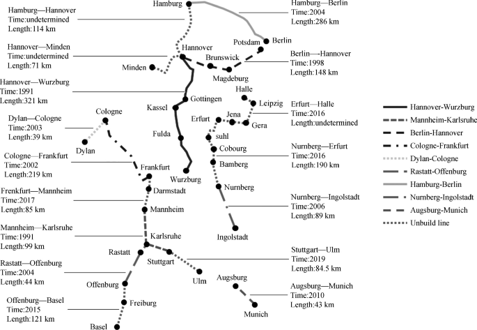
Network of HSR operation lines in Germany
-
②
Technical characteristics. There was only one serious train derailment incident since Germanic fast intercity train operated in 1991, which caused 101 deaths and 88 serious injuries. The survey results indicated that the train derailment happened due to defective material used in the wheel. This accident affected the development plan of HSR all over the world. Germany slowed down the construction plan for fast intercity train and focused on train’s safety performance. Germany also adopted the technological path of independent development in the HSR field. In 1985, Germany exploited their first ICE-V testing train which can run 409.6 km/h. At present, the ICE-5 is adopted magnetic suspension technique, and the stability and safety performance have all been improved. In addition, the interior layout design is more user-friendly (Table 4.4).
Table 4.4 List of the development of Germanic train technology -
(2)
The development trend of high-speed rail. According to the HSR project in Germany, the four intercity Express lines of Frankfurt—Mannheim, Stuttgart—Ulm, Hamburg—Hanover and Seelze—Minden are under planning and construction. Among them, the line of Frankfurt-Mannheim will connect the completely eastern region to western region of Germany. Besides that, Germany realized the intercity express transportation networks with surrounding countries, and they become the kernel trunk line to connect Europe. Now, Germany used the lines of Kolner—Düren, Offenburg—Basel, Munich—Augsburg and Berlin—Poznan, etc. for connecting Belgium, France, Switzerland, Austria and Poland respectively and realizing networked of HSR in Europe.
-
①

4.2.1.2 Development Trend of WHSR in France
France is one of the earliest countries to develop HSR in Europe. French TGV HSR technology has been the most widely used HSR technology in the world. At the same time, the TGV has the fastest average speed of wheel express train over the world. The initial success of TGV promoted the expansion of rail networks, and many new rail lines has been built in South, West and Northeast of France. The TGV connects Switzerland through France rail networks, connects Belgium, Germany and Netherlands trough the Northwest railway networks of France, and connects Great Britain through the Eurostar network. Now, the traffic range of TGV express has covered most of the territory of France. Figure 4.18 shows the French TGV.

French TGV
-
(1)
Operation condition of HSR. In 1981, the first French HSR was built and put into use. Since then, France has constructed the TGV Atlantic line, the TGV North line, the TGV Southeast extension line, the TGV Paris link line, the TGV Mediterranean line and the TGV Eastern Europe. The lines are showed in Table 4.5. The earliest constructed TGV Paris Southeast line has a maximum operating speed of 270 km/h, the TGV Mediterranean has a maximum operating speed of 300 km/h, and the maximum operating speed of the TGV Eastern Europe line reaches 320 km/h, as shown in Table 4.5.
Table 4.5 Operating lines in France -
(2)
Development trend of HSR. The network of French HSR now has formed the major structure of the HSR network, which was centered with Paris and radiated in all directions to the southeast and northwest. There are outer ring lines in the Paris and Lyon regions, and the trains of North line can be routed through the Paris outer ring road to the Southeast line, which are shown in Fig. 4.19.
Fig. 4.19 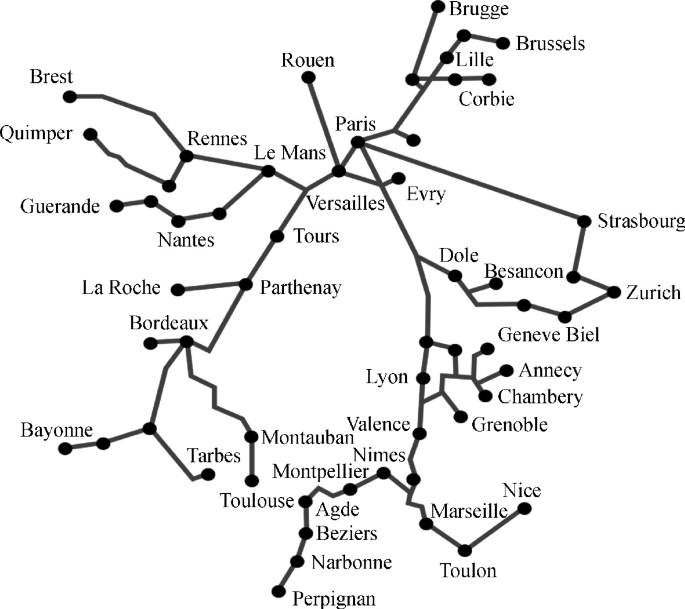
French HSR network

With the rapid development of HSR over the world, France has its own new rail planning. It includes 8 lines of the Rhine—Rhone line and the Lyons—Turin line, etc. which are showed in Table 4.6. It is estimated that by 2020, France would have built a high-speed line with a total mileage of more than 700 km, as shown in Table 4.6.
4.2.1.3 Development Trend of WHSR in Italy
Italy built the first HSR line from Rome to Florence in 1992. After two years of research, it officially began to construct the HSR network in 1994. In 1998, Italy upgraded the section of 180 km rail of Milan—Bologna line, and then the train speed was increased to 300 km/h. After 2000, the HSR lines such as Turin—Bologna, Milan—Venice and Milan-Genoa were opened continuously.
-
(1)
Operation condition of HSR. Italy is one of the first countries in Europe to build HSR line. The HSR line of Rome—Florence with the distance of 254 km was built and put into operation in 1992. In the mid-1990s, Italy further planned to build the “T” shaped high-speed transport network, which crossed the East and West and threaded the North and the South. However, affected by political and economic factors, the plan was delayed. In 2005–2006, Italian government adjusted its national transportation policy and decided to invest in accelerating the construction of the North–South HSR transportation corridor, and built a new high-speed line that connecting the major cities in the North and the South and connected with the completed HSR Direttissima in sections.
With the opening of the new HSR line in Italy, the main cities along the line, such as Bologna, Florence and Rome, have been linked together, forming a HSR network with a total length of more than 10,000 km, as shown in Fig. 4.20. The Italian HSR program is part of the EU HSR project and will be directly operational with HSR trains in neighboring countries such as France, Switzerland and Slovenia in the future.
Fig. 4.20 
Operation condition of Italian HSR
Italian HSR has been in operation for more than 20 years, and there have been security incidents during this period. On April 26, 2012, two Italian HSR trains “Frecciarossa” crashed accidentally when they came into Rome Termini Train Station, this accident made 6 people light injured. On September 24, there happened an accident of a HSR train collided with a truck in suburb of Chestell Nino of South Italy, the train diver died instantly and several passengers were injured. The two accidents have sounded the alarm for the development of Italian HSR, but in general, the operation of Italian HSR is relatively safe.
-
(2)
Development trend of HSR. European HSR lines are generally centered on France and Germany, followed by Spain and Belgium. However, with the completion of Italian “T”-shaped HSR network, Italy will also become one of the most important countries in the HSR network of Europe, as shown in Table 4.7.
Table 4.7 Operation lines of Italian HSR

4.2.1.4 Development Trend of WHSR in Spain
Spanish HSR (Spanish: Alta Velocidad Española, AVE) has a maximum speed of 300 km/h. In April 1992, Spain operated the HSR line from Madrid to Seville on the eve of the Barcelona Olympics and caught up with the development pace of the world.
-
(1)
Operation condition of HSR. After its first HSR line was successfully operated, Spain continued to accelerate the development of HSR trains and formulated new road network plans. After the construction and reconstruction, Spanish HSR has formed a modern freeway network and become one of the countries with advanced railways. Spain’s existing HSR operation lines are shown in Table 4.8.
Table 4.8 Spanish existing HSR operation lines The existing railway network in Spain is a broad rail line, and 3 quasi track high speed railways have been built as follows: Madrid—Seville (471 km), Madrid—Toledo (74 km), Madrid—Lleida (481 km). The above lines are equipped with ETCS/ERTMS-1 train operation control system, running AVE series HSR trains, with the maximum running speed of 350 km/h.
Spanish HSR train (AVE) belongs to Spanish national rails. At that time, Spain was preparing for constructing a new rail to connect Madrid and Andalusia. At the same time, Spain was also considering whether to build it into HSR, in order to connect to the big cities of Barcelona and Valencia and in the future to promote their sustainable development. At 8:42 pm, on July 24, 2013, the Spanish HSR train numbered Alvia 151 derailed on the way from Madrid to the Northern city of Fello, causing 77 deaths and 131 injuries. This is one of the biggest accidents in the history of Spanish rails, but Spain still has some lessons to learn in terms of train safety and technology.
-
(2)
Development trend of HSR. Currently the HSR lines being built and planned by Spain are: Madrid—Barcelona—Southwestern of France, Zaragoza—Bilbao, Logroñok—Southwestern of France, Madrid—Lisbon (the capital of Portugal). The old lines which will be transformed include the line of Madrid—Valencia, Madrid—Leon, Valladolid—Logroño, Seville—Verfa and Seville—Cadiz, etc. The main HSR trains in Spain are: Alaris, Alvia, Anant and Eurome.
By 2020, Spain will build a HSR line of 10,000 km. By then, 90% of Spanish nationals will encounter a HSR station every less than 50 km. Spain government will focus on building HSR lines to the North and the Mediterranean coast on the West coast of the Atlantic, and connecting the main populated areas to form a radial HSR network, as shown in Fig. 4.21.

Lines of Spanish HSR
4.2.1.5 Development Trend of WHSR in UK
The UK is the earliest country in the world to build the rail. It developed the first steam-type rail train as early as 1804. The British Railway has developed from a small and decentralized company into the four major rail giants which now are controlled by the British Rail Transport Department. It achieved the profitability of the railway through internal combustion and electrification. By the beginning of the twenty-first century, the total length of British railways has reached 1.66 million km.
-
(1)
Operation condition of HSR. The development of HSR in UK is relatively slow, and so far only one HSR line has been opened. High-speed Rail Line 1 (HS1) is the London-Paris line, the route passes the English Channel and connects France and the United Kingdom. At present, the British High-speed Rail Line 2 (HS2) is under construction, see Fig. 4.22. The construction of the HS1 took a full 16 years, whose total mileage was 109 km. Moreover, in 2003, at the beginning of the opening of the HSR, it only maintained a high-speed of 300 km/h in the French section, but when entered the British section, still maintained the maximum speed limit of 160 km/h for the traditional rails.
Fig. 4.22 
British HSR
-
(2)
Development trend of HSR. It was not until 2007 that UK sped up the HS1 route and really realized the full speed of Paris to London. British HS2 runs through the North and South of UK, with a total length of 525 km. It travels from London in the South to Birmingham in the middle of England, where it splits into the Northern cities of Leeds and Manchester. After the opening of HS2, the time from London to Manchester is nearly half shorter. The HS2 HSR project was carried out in two phases. The first phase of the project, from London to Birmingham, was 225 km in length. It was launched in 2012, started in 2017 and expected to be completed in 2026. The second phase of the project, from Birmingham to the northern cities of Leeds and Manchester, was 300 km length. The construction plan was announced in 2013 and was expected to start in 2026 and be completed in 2033. In other words, the construction of HS2’s entire line will take 20 years from start-up to completion. The first phase of the HS2 project will reduce the current time from London to Birmingham by half an hour.

4.2.2 Development Trend of WHSR in Asia
Asia is the largest continent in the world regardless of population or land area. However, not many countries in Asia have the WHSR, mainly are China, Japan, South Korea and Turkey.
4.2.2.1 Development Trend of WHSR in Japan
Japan’s transportation is developed, whether the perfection of water transport, aviation or road and rail systems are in the leading position in the world. Especially the Shinkansen express train technology, which was first developed in Japan after the 1960s, has become the symbol of the world’s advanced transportation. Japanese rail transportation network consists of national rails across the country, private rails between large and medium-sized cities, and subways in the city. So far, Japan’s rail operating lines have exceeded 22,000 km, of which the Shinkansen operating length has reached 2501.5 km, and the total number of passengers of Japan’s eight Shinkansen lines in operation has reached 89 billion.
-
(1)
Operation condition of HSR. Japan’s Shinkansen line has been recognized by passengers for its comfort, speed and punctuality. Since the opening of the Tokaido Shinkansen in 1964, it has carried nearly half of the rail passenger flow volume on the Japanese island. It has been more than 50 years since the Tokaido Shinghkansen line was put into operation in 1964. During this period, the Sanyo Shinkansen, the Tohoku Shinkansen, the Joetsu Shinkansen and the Yamagata Shinkansen have been built successively. The HSR train has developed from the 0-series of the Tokaido Shinkansen to 100 Series, 200 Series, 300 Series, E1 (MAX), 400 Series, E2, E3, E4, and E5 series, etc.
-
(2)
Development trend of HSR. The HSR currently was operated by Japan include eight HSR lines such as Tokaido Shinkansen, Sanyo Shinkansen, Tohoku Shinkansen, Joetsu Shinkansen, Nagano Shinkansen, Kyushu Shinkansen, Akita Shinkansen and Yamagata Shinkansen, with the total mileage length of 2501.5 km. There are four HSR lines under construction, namely, the Northeast Shinkansen (extended section), the Hokkaido Shinkansen, the North Land Shinkansen and the Kyushu Shinkansen (north section of the Kagoshima Line), with a total length of 580.5 km. The planned HSR lines are mainly based on the Shikoku Shinkansen, the Shikoku intersection Shinkansen, the Chūgoku intersection Shinkansen, and the Kyushu Transit Shinkansen. It mainly connects with the HSR of China, North Korea and South Korea, forming a rapid ground passenger transport corridor as shown in Table 4.9. The four rails currently under construction in Japan will be put into use successively. Figure 4.23 shows the overview of Japan’s HSR operating lines.
Table 4.9 Comprehensive present situation of Japan’s HSR lines Fig. 4.23 
Overview of Japan’s HSR operating lines

From the technical level, HSR can be divided into HSR ticket inspection technology, HSR train design technology, and HSR track protection technology. Japan’s safety research in these three areas has been at leading level in the world. Japan’s self-developed EMU from the 0 series to E5 series have greater advantages in terms of stability and speed than other countries. There are 13 types of the HSR trains currently operating in Japan like Nozomi number, Hikari number, and Kodama, Kotama, Hayate, Yamagam, Nasuye, Toki/Tanigawa, Asama, Tsubame, Komachi, and Tsubasa, they are responsible for passenger flow transport task of different routes.
4.2.2.2 Development Trend of WHSR in Korea
Since its privatization on January 1, 2005, the Korean rail has been operated by the Korea National Railways Corporation, which is headquartered in Seoul. There are 15 lines across the country with a total operating mileage of more than 3472 km, of which the length of HSR line is 420 km.
-
(1)
Operation condition of HSR. On April 1, 2004, the first “Gyeongbu” HSR line from Seoul to Busan (Daegu) was completed and opened to traffic. The maximum speed of the train was 300 km/h. In December of the same year, one group of Korean HSR-350X trains was tested. In the test, the speed was 352.4 km/h. At present, the Korea High-speed Rail (KTX) is operated by the Korean Railway (Korail) with a total mileage of 420 km. The vehicles are equipped with French TGV technology. The maximum speed can reach more than 300 km/h. Figure 4.24 shows the Korean WHSR train.
Fig. 4.24 
Korean WHSR train
-
(2)
Development trend of HSR. South Korea’s HSR from Seoul to Busan has been completed. By using this HSR line, as well as existing rail lines, South Korea’s HSR runs two lines: Gyeongbu Line (Seoul—Busan): (Haengsin—) Seoul—Yongsan—Gwangmyeong—CheonanAsan—Daejeon—DongDaegu—Milyang—Gupo—Busan; HonamLine (Seoul—Mokpo): (Haengsin) Seoul—Yongsan—Gwangmyeong—CheonanAsan—Seodaejeon—Nonsan—Nonsan—Iksan—Gimje—Jeongeup—Jangseong—Kwangju/Naju·Mokpo. In addition, Korea is currently planning one HSR connecting major cities to form a “three vertical and two horizontal” structure in space as shown in Table 4.10.
Table 4.10 Route planning of Korean HSR

South Korea’s plan of HSR routes are divided into fast-speed and high-speed according to line conditions. Here “fast-speed” refers to a line with a train operating speed of 230 km/h, and “high-speed” refers to the line whose train operating speed is set to 250 km/h. Currently, Korea is planning the lines of Wonju—Jangtu, Wonju—Jecheon, Hattan—Yeongcheon, Dongtan—Hongseong as high-speed lines, others are fast-speed lines, as shown in Fig. 4.25.

Korea’s HSR operating lines
4.2.2.3 Development Trend of WHSR in China
On August 1, 2008, the Beijing—Tianjin intercity rail with a speed of 350 km/h was put into operation, which was a major milestone in the history of China’s railway development. From December 2009 to October 2010, Wuhan—Guangzhou, Zhengzhou—Xi’an, Shanghai—Nanjing and Shanghai—Hangzhou high-speed rail were opened and operated successively; In particular, in July 2011, the Beijing—Shanghai high-speed rail was opened and put into operation, and the CRH380 series HSR train developed by China’s independent innovation realized operation and created a record of the world’s highest operating speed of 486.1 km/h.
On June 26, 2017, the “Renaissance” Electrical Multiple Unit (EMU), which is one kind of WHSR trains developed by China independently, was launched in Beijing and Shanghai. The “Renaissance” EMU is one Chinese standard EMU with completely independent intellectual property rights, with a test speed of 400 km/h and above. The EMU is equipped with a powerful safety monitoring system with more than 2500 monitoring points, which are deployed throughout the vehicle to achieve comprehensive and real-time safety monitoring of the state of the running section, bearing temperature, cooling system temperature, braking system status, and passenger compartment environment. The “Renaissance” Chinese Standard EMU also adds a collision energy-absorbing device to improve the passive protection capability. It will take the lead in realizing the operating speed of 350 km/h on the Beijing-Shanghai HSR line. China has become the country with the highest HSR commercial operating speed in the world. The “Renaissance” EMU has two models: “CR400AF” and “CR400BF”. The “A” and “B” are company identification codes, representing the manufacturer (Figs. 4.26, 4.27).

The “Renaissance” CR400AF EMU

The “Renaissance” CR400BF EMU
-
(1)
Operation condition of HSR. In current, China’s high-speed rail line network is mainly distributed in the southeast abdomen and southeast coastal areas. Among of them, there are three vertical lines, including Jing—he Line, Shi—Wu Line and Wu—Guang Line, which connect Beijing, Tianjin, Nanjing, Shanghai, Zhengzhou, Wuhan, Changsha, Guangzhou and other capital cities from north to south. These three vertical lines are also the fast passenger transportation channels of the Yangtze River Delta Economic Circle, the Bohai Economic Circle and the Middle Reaches of the Yangtze River Economic Circle. The Ningbo—Taizhou—Wenzhou Line, Fujian—Xiamen Line, Wenzhou—Fuzhou Line and the Shenzhen—Xiamen Line under construction connect the major coastal cities such as Hangzhou, Ningbo, Wenzhou, Fuzhou, Xiamen, Shantou and Guangzhou. They are the fast passenger transportation channels of the Pearl River Delta Economic Circle. The Chengdu—Wuhan Line and Hefei—Wuhan Line are connected across central China and are the main transportation lines in the East and West. Figure 4.28 shows the Chinese HSR network.
Fig. 4.28 
Chinese HSR network topological graph
-
(2)
Development trend of HSR. During less than 20 years, China has developed into a country with the fastest development, the most complete system technology, the strongest integration capability, the longest operating mileage, the highest operating speed and the largest construction scale of HSR in the world. These achievements are inseparable from the introduction of the advanced foreign HSR technology and the improvement of existing lines.
-
(3)
Recent plan of China’s HSR. The HSR network will form a certain scale and complete the construction of the “four vertical lines and four horizontal lines” network to meet the spring festival transportation. China’s HSR completes the speed-up passenger transport network centered on Beijing, Shanghai and Guangzhou; realizes the “morning and evening arrival” of 300–500 km distance; realizes the “evening arrival” of 1200–1500 km distance; and realizes the “one-day arrival” of 2000–2500 km distance (Table 4.11).
Table 4.11 Cities covered by Beijing traffic circle The neighboring capital cities will form a 1–2 h traffic circle, and the provincial capital and surrounding cities will form “a half-hour” to “one-hour” traffic circle. Except Haikou, Nanning, Kunming, Urumqi, Lhasa and Taipei, the travel time from Beijing to the provincial capital cities will be within 8 h, as shown in Fig. 4.29.
Fig. 4.29 
Recent-term planning of China’s HSR network topological graph
-
(4)
Medium-term planning of China’s HSR. By 2020, the mileage of China’s rails will reach more than 120,000 km. Among them, the new HSR lines will reach more than 38,000 km. Together with other new rails and existing speed-up lines, the China Railway Express Passenger Transport Network will reach more than 50,000 km, which connects all provincial capitals and cities of more than 500,000 people. It will cover more than 90% of the country’s population, and realize the purpose of “People’s walking is convenient, commodity’s flow is smooth”.
According to the characteristics of the “east dense and west sparse” and the station principle of “east sparse and west dense”, taking care of the west. The medium-term planning of Chinese HSR is from 2010 to 2040, using 30 years to connect the major provinces and cities across the country, forming a national network framework and forming a “five vertical lines, seven horizontal lines and eight links lines” pattern as shown in Table 4.12.
Table 4.12 The “five vertical, seven horizontal and eight links” network China’s medium-term plan of the “five vertical” HSR lines:
The specific route of the “five verticals” in the medium-term planning of China’s HSR is shown in Fig. 4.30.
Fig. 4.30 
China’s medium-term plan of the “five vertical” HSR line topological graph
-
①
Harbin—Shanghai Line.
Harbin—Fuyu—Changchun—Sipingnan—Shenyang—Yingkou—Dalian—Yantai—Qingdao—Rizhao—Lianyungang (Haizhou)—Yancheng—Nantong—Shanghai. According to the above nodes, only 14 parking stations are set up, and the stations are directly connected.
-
②
Beijing—Hongkong Line.
Beijing—Baoding—Shijiazhuang—Handanbei—Anyangnan—Zhengzhou—Luohe—Xinyangbei—Wuhan—Yueyang—Changshanan—Hengyang—Bingzhou—Shaoguan—Guangzhou—Shenzhen—Kowloon. According to the above nodes, only 17 parking stations are set up, and the stations are directly connected.
-
③
Jining—Kunming Line.
Jining—Datong—Shuozhou—Xinzhoubei—Taiyuannan—Jiexiu—Linfen—Hancheng—Xi’an—Foping—Hanzhong—Ningqiang—Guangyuan—Mianyang—Chengdu—Leshan—Mianning—Xichang—Panzhihua—Kunming. According to the above nodes, only 20 parking stations are set up, and the stations are directly connected.
-
④
Xi’an—Zhanzhou Line.
Xi’an—Ankang—Wanyuan—Dazhou—Huaying—Chongqing—Zunyi—Guiyang—Duyun—Dushan—Nandan—Chihexi—Mashanbei—Nanning—Qinzhou—Beihai—Zhanjiang. According to the above nodes, only 17 parking stations are set up, and the stations are directly connected.
-
⑤
Beijing—Shanghai Line.
Beijing—Tianjin—Cangzhou—Dezhou—Jinanxi—Jining—Xuzhou—Bengbu—Nanjing—Wuxi—Shanghai—Pudong airport.
China’s medium-term plan of the “seven horizontals” HSR line:
The specific line of “seven horizontals” in the medium-term planning of Chinese HSR is shown in Fig. 4.31.
Fig. 4.31 
China’s medium-term plan of the “seven horizontal” HSR line topological graph
-
①
Shenyang—Lanzhou Line.
Shenyang—Panjin—Jinzhou—Qinhuangdao—Tangshan—Beijing—Zhangjiakou—Jining—Hohhot—Baotou—Hangjin—Wuhai—Shizuishan—Yinchuan—Qingtongxia—Zhongwei—Baiyin—Lanzhou. According to the above nodes, only 20 parking stations are set up, and the stations are directly connected.
-
②
Qingdao-Yinchuan Line.
Qingdao—Weifang—Zibo—Jinanxi—Wucheng—Hengshui—Shijiazhuang—Yangquan—Taiyuannan—Lvliang (Lishi)—Suide—Jinbian—Otog—Yinchuan. According to the above nodes, only 14 parking stations are set up, and the stations are directly connected.
-
③
Yancheng—Xining Line.
Yancheng—Huai’an—Suqian—Xuzhouxi—Shangqiu—Kaifengdong—Zhengzhou—Luoyang—Sanmenxia—Huayin—Xi’an—Baoji—Tianshui—Dingxi—Lanzhou—Honggu—Xining. According to the above nodes, only 17 parking stations are set up, and the stations are directly connected.
-
④
Shanghai—Chengdu Line.
Shanghai—Nanjing—Hefei—Lu’an—Macheng—Wuhan—Qianjiang—Jingzhou—Yichang—Shuibuya (or Wufeng)—Enshi—Qianjiang—Peilingxi—Chongqing—Suining—Chengdu. According to the above nodes, only 15 parking stations are set up, and the stations are directly connected. The line goes southeast, passing Suyang–Huzhou–Hangzhou–Shaoxing–Ningbo, and eastward can be along north of the Yangtze river, passing Yangzhou, Taizhou to Nantong.
-
⑤
Shanghai—Kunming Line.
Shanghai—Jiaxing—Hangzhou—Jinhua—Quzhou—Shangrao—Yingtan—Nanchangnan—Xinyu—Pingxiang—Changshanan—Loudi—Shaoyang—Dongkoubei—Huaihua—Yuping—Kaili—Duyun—Guiyang—Anshun—Guanling—Panxian—Qujin—Kunming. According to the above nodes, only 24 parking stations are set up, and the stations are directly connected.
-
⑥
Shanghai—Nanning Line.
Shanghai—Ningbo—Taizhou—Wenzhou—Fuding—Ningde—Fuzhou—Putian—Quanzhou—Xiamen (Tong’an)—Zhangzhounan—Yunxiao—Shantou—Shanwei—Huizhou—Guangzhou—Zhaoqing—Yunfu—Yunan—Wuzhou—Guipingdong—Guigang—Nanning. According to the above nodes, only 23 parking stations are set up, and the stations are directly connected.
-
⑦
Hangzhou—Guangzhou Line.
Hangzhou—Jinhua—Suichang—Longquan—Songxi—Jianou—Nanping—Shaxian—Sanming—Yong’an—Zhangping—Longyan—Yongding—Meizhou—Guangzhou.
Thirdly, China’s medium-term plan of the “eight links” HSR line. The specific line of the “eight links” network in the medium-term planning of China’s HSR is shown in Fig. 4.32.
Fig. 4.32 
China’s medium-term plan of the “eight links” HSR line topological graph
-
①
Tianjin—Tangshan Line: Tianjin—Tangshan.
-
②
Kaifeng—Hekou Line: Kaifengdong—Heze—Dongping—Jinanxi—Binzhou—Dongyingbei—Hekou.
-
③
Nanjing—Nantong Line: Nanjing—Yangzhou—Taizhou—Nantong.
-
④
Nanjing—Ningbo Line: Nanjing—Shuyang—Huzhou—Shaoxing—Ningbo.
-
⑤
Jinhua—Wenzhou Line: Jinhua—Lishui—Wenzhou.
-
⑥
Wuhan—Fuzhou Line: Wuhan—Huangshixi—Wuxue (Jiangnan)—Jiujiangxian—De’an—Nanchangnan—Fuzhou (Jiangxi)—Shaowu—Nanping—Fuzhou.
-
⑦
Nanping—Xiamen Line: Nanping—Sanming—Datian—Xiamen (Tong’an).
-
⑧
Hengyang—Nanning Line: Hengyang—Qidong—Yongzhou—Quanzhou—Liuzhou—Laibin—Binyang—Nanning.
-
①
-
(5)
Long-term planning of China’s HSR. The long-term planning of China’s HSR is from 2040 to 2070, and it will take another 30 years to complete at the latest 2100. The east dense is realized, and the west is connected into a network (that is, the major transportation hubs in the west is connected). The major transportation node cities and tourist attractions are connected, so that major cities in the western region can access any coastal provinces and regions, and the WHSR Network of “eight vertical lines and eight horizontal lines” is realized as seen in Fig. 4.33.
Fig. 4.33 
“Eight horizontal and eight vertical” network of China’s HSR
China’s long-term planning of the “eight vertical” HSR lines is as shown in Fig. 4.34.
Fig. 4.34 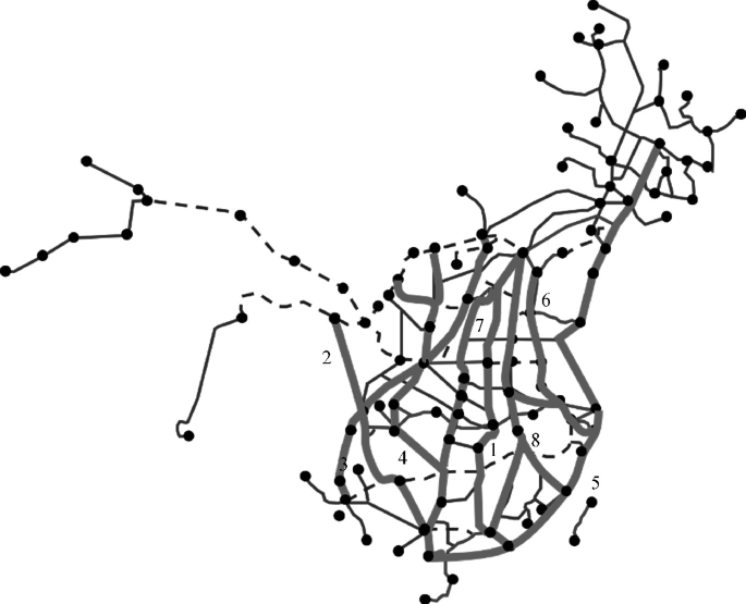
“Eight vertical” HSR line topological graph
-
①
Coastal Channel. HSR of Dalian (Dandong)—Qinhuangdao—Tianjin—Dongying—Weifang—Qingdao (Yantai)—Lianyungang—Yancheng—Nantong—Shanghai—Ningbo—Fuzhou—Xiamen (Fangchenggang) (one of them, the line of Qingdao to Yancheng is using Qinglian line, Lianyan rail line, the section of Nantong to Shanghai in Shanghai-Nantong rail). It connects the eastern coastal areas and runs through the urban agglomerations of Beijing-Tianjin-Hebei, South central of Liaoning, Shandong Peninsula, Dongpuhai, the Yangtze River Delta, the west coast of the Straits, the Pearl River Delta and Beibu Gulf.
-
②
Beijing—Shanghai Channel. The HSR line of Beijing—Tianjin–Jinan—Nanjing—Shanghai (Hangzhou), which includes the HSR line of Nanjing—Hangzhou and Bengbu—Hefei—Hangzhou, at the same time, it connects to the HSR line of Beijing—Tianjin—Dongying—Weifang—Linyi—Huaian—Yangzhou—Nantong—Shanghai, also connects to North China and East China, and penetrates Beijing—Tianjin—Hebei, Yangtze River Delta and other urban agglomerations.
-
③
Beijing—Hongkong (Taiwan) Channel. The HSR line of Beijing—Hengshui—Heze—Shangqiu—Fuyang—Hefei (Huanggang)—Jiujiang—Nanchang—Ganzhou—Shenzhen—Hongkong (Kowloon); Another line is: Hefei—Fuzhou—Taipei, including the railway of Nanchang—Fuzhou (Putian). It connects North China, Central China, East China and South China, and runs through Beijing—Tianjin—Hebei, the middle reaches of the Yangtze River, the west coast of the Straits, and the Pearl River Delta.
-
④
Beijing—Harbin and Beijing—Hongkong—Macao Channel. The HSR line of Harbin—Changchun—Shenyang—Beijing—Shijiazhuang—Zhengzhou—Wuhan—Changsha—Guangzhou—Shenzhen—Hongkong, includes the HSR line of Guangzhou—Zhuhai—Macao. It connects Northeast China, North China, Central China, South China, Hong Kong and Macao, and integrates urban groups such as Harbin—Changchun, South Central Liaoning, Beijing—Tianjin—Hebei, Central plains of China, the middle reaches of the Yangtze River and the Pearl River Delta.
-
⑤
Hohhot—Nannjing Channel. The HSR line of Hohhot—Datong—Taiyuan—Changzhi—Jincheng—Jiaozuo—Zhengzhou—Xiangyang—Changde—Yiyang—Loudi—Shaoyang—Yongzhou—Guilin—Nanning. It connects North China, Central plains, Central China, and South China, and runs through urban areas such as Hohhot—Baotou—Ordos—Chongqing, Central Shanxi, Central Plains, the middle reaches of the Yangtze River, and the Beibu Gulf.
-
⑥
Beijing—Kunming Channel. The HSR line of Beijing—Shijiazhuang—Taiyuan—Xi’an—Chengdu (Chongqing)—Kunming, includes the high- speed rail of Beijing—Zhangjiakou—Datong—Taiyuan. It connects the North China, Northwest China, and Southwest China, and runs through the city clusters of Beijing-Tianjin–Hebei, Taiyuan, Guanzhong Plain, Chengdu—Chongqing and Central Yunnan.
-
⑦
Baotou (Yinchuan)—Haikou Channel. The HSR line of Baotou—Yan’an—Xi’an—Chongqing—Guiyang—Nanning—Zhanjiang—Haikou (Sanya), which includes the HSR line of Yinchuan—Xi’an and Hainan Round Island HSR. It connects the Northwest, Southwest, and South China, and runs through the city clusters of Hohhot—Baotou—Ordos, Ningxia along the Yellow River, Guanzhong Plain, Chengdu—Chongqing, Central Guizhou, and the Beibu Gulf.
-
⑧
Lanzhou (Xining)—Guangzhou Channel. The HSR line of Lanzhou (Xining)—Chengdu(Chongqing)—Guiyang—Guangzhou, which connects the Northwest, Southwest, and South China, and runs through the city clusters such as Lanzhou—Xining, Chengdu—Chongqing, Central Guizhou, and the Pearl River Delta.
China’s long-term planning of the “eight horizontal” HSR lines is as shown in Fig. 4.35.
Fig. 4.35 
“Eight horizontal” HSR line topological graph
-
①
Suifenhe—Manzhouli Channel. The HSR line of Suifenhe—Mudanjiang—Harbin—Qiqihar—Hailar—Manzhouli, which connects the area of Heilongjiang and East Inner Mongolia.
-
②
Beijing—Lanzhou Channel. The HSR line of Beijing—Hohhot—Yinchuan—Lanzhou, which connects to the North, Northwest of China, runs through the city clusters of Beijing—Tianjin—Hebei, Hohhot—Baotou—Ordos, Ningxia along the Yellow River, Lanzhou—Xining.
-
③
Qingdao—Yinchuan Channel. The HSR line of Qingdao—Jinan—Shijiazhuang—Taiyuan—Yinchuan (Among of them, the section of Suide to Yinchuan is using the rail line of Taiyuan—Zhongwei), which connects the East, North, Northwest of China, runs through the city clusters of Shandong Peninsula, Beijing—Tianjin—Hebei, Taiyuan, Ningxia along the Yellow River.
-
④
Along the Yangtze River Channel. The HSR line of Shanghai—Nanjing—Hefei—Wuhan—Chongqing—Chengdu, which includes HSR line of Nanjing—Anqing—Jiujiang—Wuhan—Yichang—Chongqing, Wanzhou—Dazhou—Suining—Chengdu (Among of them, the section of Chengdu to Suining is using the railway of Dacheng—Chengdu). It includes the East, Central and Southwest of China, runs through the city clusters of Yangtze River Delta, Middle reaches of the Yangtze River and Chengdu—Chongqing.
-
⑤
Shanghai–Kunming Channel. The HSR line of Shanghai—Hangzhou—Nanchang—Changsha—Guiyang—Kunming, which connects the East, Central, Southwest of China, runs through the city clusters of the Yangtze River Delta, Middle reaches of the Yangtze River and Central Guizhou, Central Yunnan.
-
⑥
Xiamen—Chongqing Channel. The HSR line of Xiamen—Longyan—Ganzhou—Changsha—Changde—Zhangjiajie—Qianjiang—Chongqing (Among of them, the section of Xiamen to Ganzhou is using the rail line of Longyan—Xiamen, Ganzhou—Longyan, and the section of Changde to Qianjiang is using the rail line of Qianjiang—Zhangjiajie—Changde). It connects the west coast of the Taiwan Straits, South Central, Southwest of China, runs through the city clusters of the west coast of the Taiwan Straits, Middle reaches of the Yangtze River and Chengdu–Chongqing.
-
⑦
Guangzhou—Kunming Channel. The HSR line of Guangzhou—Naning—Kunming, which connects the South, Southwest of China, runs through the city clusters of the Pearl River Delta, Beibu Gulf, and the Central Yunnan.
-
⑧
Luqiao Channel. The HSR line of Lianyungang—Xuzhou—Zhengzhou—Xi’an—Lanzhou—Xining—Urumqi, which connects the East, Central, Northwest of China, runs through the city clusters of east Longhai, Central plain, Guanzhong plain of China, Lanzhou—Xining and the northern slope of Tianshan Mountain. China's railway is developing continuously, and the construction of China's “eight vertical and eight horizontal” HSR network is gradually improved. The situation of China's WHSR lines is shown in Fig. 4.36.
Fig. 4.36 
China’s WHSR lines (picture from the network)
-
①


4.2.3 Development Trend of WHSR in America
Currently, there is no HSR in America, of which the United States may be the first country in North America to have HSR, and Brazil may be the first country in South America to have HSR.
-
(1)
HSR in the United States. The United States was once the king of the rails in the world. The US rail freight is still in the leading position in the world, but the development of HSR in the United States is particularly slow: it proposed the HSR construction plan in the 1960s, but the Western California Interstate HSR is expected to be completed as early as 2020. There are several reasons for the slow development of HSR in the United States: low density population distribution, highly developed road network, the high penetration rate of automobiles and developed aviation industries, etc.
The United States hopes to create 11 HSR channels, three in the densely populated northeastern region, and then extends to Florida, the Northern coast of Mexico Gulf, the Midwest, Texas, the Pacific Northwest and California. The United States will develop one HSR network of 27,000 km in the next 20–30 years, as shown in Fig. 4.37.
Fig. 4.37 
HSR planning map of The Unite States
-
(2)
HSR in Brazil. The Brazilian government has placed the development of rail transport at a priority over the investment in large infrastructure projects and has developed a medium-term plan for the rail network. The main content of the plan is to improve the rail network structure, including rail safety system, rail speed increase, suburban transportation, public rail intersect bridge, housing demolition and residential resettlement along the rail, etc. It is expected to invest 1 billion Real in 5 years. At present, only one HSR line in Brazil is under planning, as shown in Fig. 4.31. It is expected to depart from Campinas and pass through 11 cities in the middle of São Paulo, Jacarere, Taubate and Cruzema, and finally arrive in Rio de Janeiro with a total mileage of 511 km and a planned speed of 285 km/h. It will shorten 1.5 h from São Paulo to Rio de Janeiro. Figure 4.38 shows the Brazil’s first HSR line.
Fig. 4.38 
Brazil’s first HSR line


4.3 Development Vision of WHSR
The development of HSR has a major impact on national and regional development strategies. At present, many countries in the world have begun to build transnational HSR, as soon as possible to achieve rapid road access between countries and regions, eliminate the impact of geographical restrictions between countries, and accelerate exchanges and cooperation of economy and resources between regions and regions. Considering the overall situation of national development, HSR has a far-reaching strategic influence. For the strategic, national security can be guaranteed. Especially considering the overall situation of global development, the development of HSR has a profound impact on the world political economy. HSR can promote world integration and realize “global village”.
As a safe and reliable, fast and comfortable, large-capacity, low-carbon and environmentally-friendly transportation mode, HSR has become an important trend in the development of the world transportation industry. At present, 9 countries own HSR in Europe are planning to invest 200 billion US dollars for extending the HSR with a total mileage of 7000 km to 16,000 km. Japan has already launched the construction of the magnetic levitation central Shinkansen, which will connect Tokyo and Osaka. The train running on this line will become the fastest in the world at speed of 500 km/h. The United States, the traditional country that based on road transport, now is starting to develope HSR. By 2030, it will cover 80% of Americans. The development of China’s HSR is from scratch, and China has also changed from a seeker to a front-runner. The scale and speed of construction are at the forefront of the world. By 2020, 90% of Chinese people can travel by HSR. Therefore, in 2020, the world will enter not only the “era of high-speed rail”, but also the era of “global village”.
4.4 Summary
The punctuality, speed and comfort of HSR are favored by tourists from all over the world and the HSR has become the preferred mode of transportation for travel. Comparing with other modes of transportation, HSR has strong conveying capacity, fast speed, good safety, highly punctuality rate, low energy consumption, less impact on the environment, less land occupation, comfort and convenience, considerable economic benefits and good social benefits. With its unique technical advantages to adapt the new demand of modern social and economic development, the HSR has become an inevitable choice for the development of countries around the world. The development and operation practice of China’s HSR shows that it has great development space and potential in China. China should make full use of its latecomer advantage to realize the leap-forward development of China’s HSR.
Author information
Authors and Affiliations
Corresponding author
Rights and permissions
Copyright information
© 2023 Southwest Jiaotong University Press
About this chapter

Cite this chapter
Hu, Q., Qu, S. (2023). Wheel High-Speed Rail (WHSR). In: A Brief History of High-Speed Rail. Springer, Singapore. https://doi.org/10.1007/978-981-19-3635-7_4
Download citation
DOI: https://doi.org/10.1007/978-981-19-3635-7_4
Published:
Publisher Name: Springer, Singapore
Print ISBN: 978-981-19-3634-0
Online ISBN: 978-981-19-3635-7
eBook Packages: EngineeringEngineering (R0)