
Abstract
The policy of land use management for natural disaster mitigation has been shared globally as an increased number of natural disasters have occurred. Among them a set of unique systems have been established in England. The characteristics of the English systems are found in their quantitative risk assessment, flexible and process-oriented planning permission, and comprehensive land use control combined with regulations, insurance, risk information disclosure, and indirect intervention by the central government. On the other hand, another unique set of systems in this field have been established and in operation in France for more than 30 years. The characteristics of the French systems are found in its qualitative risk assessment, disaster-prevention-specific planning system independent of the standard city planning system, regulation by practical zoning harmonized with actual land use, and comprehensive land use control combined with different policy instruments and direct intervention by the central government. It is still evolving putting more emphasis on ex ante disaster prevention measures. Although neither the UK nor France has achieved perfect forms of land use management for flood disaster mitigation, every possible policy instrument is employed in their own unique way, and the best management system is being pursued by trial and error.
Access provided by CONRICYT-eBooks. Download chapter PDF
Keywords
1 Introduction
The importance of disaster mitigationFootnote 1 measures through land use management has been shared globally as an increased number of natural disasters have occurred, which are attributed to global warming. Among these measures that have been implemented in different countries, there are a number of remarkable ones. By paying close attention to the historical conditions and the social background behind those measures, they can give other countries valuable insights for considering their own disaster mitigation measures. This chapter introduces an overview of such mitigation measures implemented in the United Kingdom (UK)Footnote 2 and France, while analyzing and comparing each other.
Around the world, diverse types of flood disaster mitigation measures have been implemented. In addition to land use regulation, which is one representative approach, they include disclosure of risk information and insurance systems. Although land use regulation for natural disaster mitigation is simple and clear as an idea, its application to the real world typically faces a very high hurdle. Although land use regulation has such difficulty being implemented alone, it can be executed more smoothly by being combined with other policy instruments. The UK and France have successfully implemented it by combining different policy instruments comprehensively; thus, the two countries serve as excellent examples by comparing and discussing significant features of each. In the UK, the Environment Agency provides citizens with flood risk information via the Internet. Based on this information, land use control for flood disaster mitigation is implemented using the standard city planning scheme, and flood insurance is provided by private insurance companies. There is a close collaborative relationship between the UK government and the insurance industry, and they have been continuously pursuing the optimum role-sharing by trial and error (22.2). On the other hand, France has a special planning system dedicated for natural disaster mitigation, which is called the PPR (Plan de prévention des risques naturels prévisibles). The PPR, which was formulated by the state government, is being operated in combination with the natural disaster insurance system, CatNat (Catastrophes Naturelles). The CatNat is a public insurance system supported by the state government and is connected with PPRs in the country’s legal system. The CatNat system has been continuously reformed to put more importance on efforts for pre-disaster mitigation than on the post-disaster compensation (22.3).
In Sects. 21.2 and 21.3, we analyze these countries’ land use management for natural disaster prevention and then summarize them in Sect. 21.4. In this chapter, the output of the interviews conducted in 2008 in England and France is used. The outline of interviews is explained at the end of the chapter.
2 Overview of the UK’s Land Use Control for Flood Disaster Mitigation and Insurance System
In England, about 10 % of all properties are located on the floodplain, and 11 % of all new homes have been built in flood hazard areas since 2000. In such a context, a policy report issued for the UK government pointed out the necessity of strong planning control (Pitt 2008, ch. 1 p. 61). In addition, in the summer of 2007, a major flood occurred in the central part of the country. This flood has been called the largest emergency event in peacetime since World War II (Pitt 2008, forward). The amount of insurance money paid out due to this event reached 3 billion pounds, which is the most expensive payout ever for a natural disaster that has occurred in the UK. It is with this experience that the UK has developed its own unique policies on land use management. One of the major characteristics of the land use management policies is that the risk assessment, which is at the basis of the system, is implemented based on objective quantitative data. In addition, the policy’s characteristics include that the Environment Agency operates the risk assessment system and provides the risk information in a highly integrated manner in cooperation with the state government and private companies. We will summarize below the land use regulation for flood disaster mitigation, the disclosure of flood risk information, and the flood insurance in the UK’s system.
2.1 Land Use Regulation for Flood Prevention in the City Planning Process
In the UK, the system of land use regulation for flood prevention was established in 2001 in a policy document called the Planning Policy Guidance 25 (PPG25). Then, the Planning Policy Statement 25 (PPS25) was developed by amending the PPG25 in December 2006 (DCLG 2006), and its practice guide (DCLG 2008) was published in July 2008. They had served as effective guidelines in this field until recently with minor revisions in 2010 and 2009, respectively. However, since the change of government from labor to conservative in 2010, the country’s city planning administration was largely streamlined,Footnote 3 and policy documents were streamlined accordingly. As a result, current effective basic policies are documented in the National Planning Policy Framework (NPPF) (DCLG 2012a) and its technical guidance (DCLG 2012b). As the NPPF only stipulates the general policy direction, it is important to review the NPPF’s technical guidance as well in order to understand the country’s land use control for flood disaster mitigation.Footnote 4
2.1.1 Land Zoning and the Environment Agency’s Flood Map
In the UK, land use control for flood disaster mitigation is conducted within the framework of the regular city planning process. The DCLG, which is in charge of city planning, has released the NPPF and its technical guidance to facilitate the local planning authorities (LPAs, municipal authorities in charge of city planning) to develop their city plans. In these documents, the land which is subject to city planning is classified into four different zones (zones 1, 2, 3a, and 3b) based mainly on the probability of floods (DCLG 2012b), pp. 3–5) (Table 21.1).
In addition, the Environment Agency has developed and published a nationwide flood map, in which zones 1, 2, and 3s are shown in white, pale blue, and blue, respectively. Figure 21.1 shows a part of the flood map of Central London. The areas along the Thames River, which is serpentine, are colored pale blue and blue, whereas land protected by banks is shown with hatched lines.

A part of the UK’s flood map (Source: webpage of the Environmental Agency)
On the other hand, in the NPPF guidance, land usage is classified based on the vulnerabilities against flood risks as shown in Table 21.2 (DCLG 2012b, pp. 6–7). Furthermore, Table 21.3 shows the permitted land use for each zone in a matrix, based on the zoning and flood vulnerability classification shown above. Zone 1, which is white colored, is free from land use regulation, and the regulations become gradually stricter when moving from zone 2 to zone 3a and finally to zone 3b. In zone 3b, a functional floodplain, almost all land use should be avoided (DCLG 2012b, pp. 8).
2.1.2 Procedure for Planning Application
When developing city plans, the LPAs must adhere to the national policies described in the NPPF and its guidance. In addition, the permission of individual planning applications for development must be implemented according to the policies in the city plan. Thus, the specific development is controlled by the national policies, through the city plan formulation and the individual permissions for development. On the other hand, if there are substantial reasons to be considered apart from the content of the city plan, it is permitted for the LPAs to take them into account.Footnote 5 Therefore, each planning application is not completely controlled by the language of the policy documents. The LPA may impose certain conditions on the applicants when granting them permission (ODPM 2005, 20), while the developers are also allowed to negotiate with the LPAs in return for undertaking some obligations.Footnote 6
What is unique here is the process called “sequential approach.” In this approach, when a planning application is filed in zone 3 land, for example, it is first determined whether it is possible to implement the development plan in zone 1 or zone 2, which are both safer than zone 3. If the plan could be implemented in zone 1 or 2, implementation in zone 3 is not permitted (PPS25 16–20).Footnote 7 Furthermore, a standard for an “exception test” must be applied. Even if it is concluded that a development application cannot be implemented in alternative zones by the sequential approach, the application will earn permission to be implemented in the originally intended site only when the application passes the exception test. This exception test states, in short, that even if it is a dangerous area, when the necessity of the development is observed from a broader view with the concept of sustainable development (when the benefit of the sustainable development is larger than the risk associated with the development), permission is given (PPS25 19. D.9). In the end, development applications filed for zones 2 or 3 (“dangerous zones”) can be permitted if: (1) the development cannot be implemented in a safer area and (2) the benefits from the development exceed the risk associated with the development. Here is room for the LPAs to use great discretion.
2.1.3 Flood Risk Assessment
When submitting development applications for the dangerous zones, developers must conduct a “flood risk assessment” to demonstrate that the development meets the requirements of the sequential approach and the exception test (PPS25 E8–E10). This risk assessment is referred to as site-specific flood risk assessment (FRA). Prior to an FRA, which is conducted by the developer, a strategic flood risk assessment (SFRA) is performed at the municipal level by the LPAs (DCLG 2012b, pp. 8–9). The SFRA specifies a standard for the LPAs’ assessment of planning applications (both the assessment process and the resultant report are referred to as “SFRA”).
The Environment Agency’s flood maps only consider floods from rivers and those from the sea such as a high tide. It does not take into account the impact from inland waters nor the effectiveness of flood prevention facilities. As such, the LPAs conduct land zoning by themselves based on the Environment Agency’s flood map while also taking into account local information regarding inland waters and flood prevention facilities. The resultant zoning is shown in a map included in their SFRAs. The actual land use regulation for flood disaster mitigation is performed based on the SFRA map, not on the Environment Agency’s flood map. Therefore, in some cases, there are differences between the zoning specified by the Environment Agency’s flood map and the zoning specified by the SFRA, which is used for the actual regulation. The differences stem from the risk assessment of the inland waters and the safety effectiveness of flood prevention facilities (Interview (3)). In other words, each local governmental body makes its own map to serve as basis for regulation by customizing the information provided by the Environment Agency (Fig. 21.2). However, when the LPAs develop the SFRAs, they must consult with the Environment Agency (DCLG 2012b, p. 8).Footnote 8 This rule allows the Environment Agency to prevent the local authority from changing the existing zoning boundaries too permissively, especially when a local authority has a strong tendency to promote development. According to Interview (3), “without the nation’s strong policy, LPAs are affected by local political pressures. This is why Environment Agency intervenes in local land use control.”

The Environment Agency’s flood map (left) and the map of the city of Sheffield included in a SFRA (right) (Source: PRILIT 2011, pp. 93–94)
2.1.4 The Environment Agency’s Opinion and the Call-In by the Secretary of State
If the LPA is going to grant a planning permission intended for an area in the dangerous zones, the authority must officially notify the Environment Agency (Fig. 21.3). Then, if the Environment Agency disagrees with granting the permission, the three parties (the LPA, the Environment Agency, and the applicants) must confer about this plan. In this consultation, the three parties seek a reasonable compromise by understanding each other’s concerns and in some cases making some changes or adding some conditions to the plan, as needed.

The Environment Agency’s opinion and the city planning secretary of states’ call-in
However, if the trilateral dialogue does not reach an agreement and the LPA still desires to grant the permission, against the advice of the Environment Agency, the LPA must officially notify the secretary of state in charge of the city planning. Then the secretary of state can “call-in.”Footnote 9 The call-in system is one in which the state government can intervene in the decision-making of local governments regarding the development of city plans and individual planning permissions, and the state government may work in place of the local government if the state government finds it necessary to do so. When a call-in is selected, the LPA loses its permission authority regarding the concerned matter, and it will be handled by the state government including granting permission or rejecting an application.
However, the call-in system, which demonstrates the state government’s strong authority, only has been applied in some exceptional cases such as when the applications are against the major national policy.Footnote 10 Almost all of the applications have been granted or withdrawn as a result of the consultation among the concerned parties. According to a DCLG officer, the call-in system had only been used four times between the system’s introduction into the flood land use control in January 2007 and the date of the interview, November 2008 (Interview (3)).
2.1.5 Summary
As discussed above, the UK’s development control in the flood risk zones is much more flexible than the image created by the words of “land use regulation.” However, the UK government has well-developed assessment procedures, which include a requirement to developers to conduct a risk assessment, sequential approach, exception test, and consultation among stakeholders. In this land use regulation system, it is intended to combine flexible control and well-developed procedures. In our Interview (3), the author asked the question “How much effective is the UK’s land use regulation for the “prevention” of development in the dangerous zones?” The response was that this regulation’s goal is not to “prevent” but to “control” and “mitigate” (Interview (3)). As demonstrated by this answer, the UK does not aim to simply suppress development but to adjust the land use and mitigate potential damages.
In this system, the leading players are the LPAs. One of the major features of this country’s system is the flexibility of having the decision which is sought by stakeholders based on the judgment on the ground and taking advantage of the authority’s discretion. On the other hand, even though the state government has a strong policy instrument with the call-in system, it generally plays an indirect role such as establishing national policies.
2.2 Disclosure of Risk Information
2.2.1 Flood Map
Information disclosure is an important mechanism, which not only functions by itself to improve the society’s ability to prevent disaster but it also supports the land use control for flood disaster mitigation from its very foundation, as described below.
The Environment Agency publishes the nationwide flood map on its official website. This map is used not only by the citizens to understand the flood risk that their residential area faces in order to develop better evacuation and disaster mitigation plans but also by the LPAs to implement the city planning regulation through local customization of the agency’s flood map. Furthermore, as mentioned below, it is used by private insurance companies as basic information for their risk assessments when they are underwriting insurance. This map can be accessed by anyone, without any charge. Users can check an area-specific level of flood risk by inserting the area’s name or its postal code on the Environment Agency’s webpage. The flood map is updated every 3 months. When a flood occurs, the flood map will be updated with the actual flood data at the next scheduled update (EA 2006, p. 7).
As seen with the information disclosure system, the UK does not seek perfection but they try to quickly provide the best information possible. For example, the PPS25 repeatedly points out the increased flood risks due to the global warming (PPS25 2, 7), whereas it also states that the Environment Agency’s flood map does not sufficiently reflect the potential increase of the future risk.Footnote 11
On the agency’s website, the frequently asked questions (FAQ) regarding the flood map are also available. In these FAQs, the agency states that if someone does not agree with the map’s classification of his/her land as being in a dangerous zone, he/she can send a request to the Environment Agency to make a change in the map. However, when submitting the request, the landowner must have some scientific evidence, not just anecdotal evidence.Footnote 12 As demonstrated in this answer, in the UK, risk information is not given in a unilateral way by an authority, but is published, verified, and maintained in communications between the authority and the residents, who are the consumers of the risk information. This is not just a “polite face” but an actually functional system, in which many individuals have actually submitted such requests and achieved a number of corrections in the flood map (Interview (1)).Footnote 13 Such a government stance is remarkable from the perspective of enhancing the effectiveness of land use control. The PPS25 clearly indicates the role of each stakeholder related to flood control, including the residents’ responsibilities. For example, the PPS25 states that “there is no general statutory duty on the Government to protect land or property against flooding (PPS25 21)” and that “landowners have the primary responsibility for safeguarding their land and other property against natural hazards such as flooding (PPS25 22).” To seek the sharing of responsibilities among the stakeholders, disclosing risk information and ensuring interactivity have crucial importance.Footnote 14
2.2.2 Recent Development
In response to the development of the EU Floods Directive, a system reform was conducted in the UK, resulting in new advancement in disclosure of flood risk information. The EU’s directive on flood risk assessment issued in 2007Footnote 15 requires the EU member countries to assess flood risk, designate flood risk areas, and create their flood hazard maps and flood risk maps. Furthermore, in the future, the member countries must develop flood risk management plans based on these maps. Accordingly, the UK has passed national laws to implement these tasks, and works according to the Flood Risk RegulationsFootnote 16 have been advanced. Emanating from the EU’s legislation, the UK’s work on the development of flood hazard maps and flood risk maps advanced under the coordination between the Environment Agency and local governments. On December 12, 2013, the Environment Agency released its new flood maps on its websiteFootnote 17 (Fig. 21.4). This newly released flood maps are composed of four different ones:

The published webpage provides access for each flood map (Source: The Environment Agency’s webpage)
-
1.
Flood map for planning (rivers and the sea)
-
2.
Risk of flooding from surface water
-
3.
Risk of flooding from reservoirs
-
4.
Risk of flooding from rivers and the sea
Among these four maps, map (1) is a conventional flood map of the country. Map (2), which was published for the first time, shows the risk of floods caused by fallen rainwater that does not drain away or penetrate into the soil. On this map, the probability of this kind of flood is indicated in four levels (high, medium, low, and very low). By clicking any point on the map, it provides not only the probability of flooding but also the projected water depth and flow rates. Map (3) shows the impact of a collapse of reservoirs (25,000 m3 or more), whereas map (4) is intended for use in risk assessment for flood insurance. See the next section for more details about the last map.
2.3 Flood Insurance
Flood insurance not only gives relief to affected people but it also serves as a useful measure to ensure the effectiveness of land use control for flood disaster mitigation. Generally, when considering insurance as an economic system, flood insurance is expected to induce insured persons to take actions for disaster mitigation by setting the premium rates based on the risks. For example, in an area that faces an extremely high risk of floods, land use is expected to be suppressed by the prohibitively high premium rates. The UK pursues this function of insurance from its aspect as an economic system.Footnote 18
2.3.1 Basic Mechanism of Flood Insurance in the UK
First, a prominent feature of the UK’s flood insurance is that it is provided as a part of the basic coverage of private insurance companies’ residential insurance products,Footnote 19 and there is no public flood insurance provided directly by the government. Whether or not a resident has flood insurance is fully optional. As the flood insurance is provided by private insurance companies, there is no uniform content in the insurance policies. There are also no uniform methods for premium rate setting across the insurance industry. Typically, the premiums are decided based on the location’s flood risk, as well as the structure, size, and age of the building. When assessing the flood risk, insurance companies use their own flood data in addition to the flood data provided by the Environment AgencyFootnote 20 and private data analysis companies.
Because the UK’s flood insurance is provided by private companies, there is no public financial support from the government for premiums. Furthermore, there have not been any reinsurance or insurance premium pool systems operated by the state government or the whole industry. However, currently, the insurance industry is advancing the establishment of a pool system called “Flood Re” as described below.
2.3.2 Provision of Risk Information for Insurance Assessment
As described above, the previous flood map was provided under the name of “flood map,” which only considered floods from major rivers and the sea and did not take into account the impact from inland waters or the existence of flood prevention facilities. Although the flood map’s main intended application was land use control, it was also used as essential information for setting flood insurance premiums. When a viewer clicked at any point on the map, it showed the assessed risk of the point considering the existence and the effectiveness of the flood prevention facilities in three levels (high, medium, and low). After the EU’s Floods Directive was issued (DEFRA 2009, p. 6), the map was enhanced in December 2013, and this risk information is now shown on an independent map titled “Risk of Flooding from Rivers and the Sea,” on which the degree of risk is shown by four levels (high, medium, low, and very low). Private insurance companies individually set their premium rates based on the risk information shown on this map after adding the results of the individual building’s risk assessment to it. As such, although the land use control for flood disaster mitigation is not directly linked to the flood insurance system as a legal institution, they both indirectly interact via the information provided by the public organization and risk assessment conducted by private companies.Footnote 21
2.3.3 Linkage Between Flood Insurance and Land Use Control (Alerts for Developers)
Collaboration between the government and the insurance industry is not just in the provision of information. Guidance issued from the Association of British Insurers (ABI) states, “It is highly unlikely that insurance (and consequently mortgages) would be advanced for developments that proceed against EA advice, except at a level that could make them unaffordable to households” (ABI 2003, 17). On the other hand, regarding such a stance by the insurance industry, the UK government raised awareness among developers in stating that “The Association of British Insurers and the Council of Mortgage Lenders will comment on individual proposals on which the Environment Agency objects and where there appears to be a high risk. Those proposing development, especially speculative investment, are advised to consult ABI guidance…” (PPS25 H12).Footnote 22 Through such an interaction between the government and the ABI, developers who are going to implement reckless development plans have been warned. As described below, in France, developers who do not comply with the land use controls are excluded from semipublic insurance in a systematic manner, whereas the similar effect occurs in the UK in an indirect manner. According to an officer, this measure has produced a highly strong effect (Interview (3)).
2.3.4 Collaboration Between the Government and Private Companies (The Partnership Approach)
Although the UK pursues the position of flood insurance as an economic system, if this position is pursued without any restrictions, a concern develops that socially disadvantaged residents, who typically live in areas with high risks, will be excluded from the insurance system. To avoid such a situation, it is necessary that the insurance industry has a certain collaborative relationship with the state government. Such a partnership is represented by the ABI’s “Statement of Principles on the Provision of Flood Insurance” (“Statement of Principles”) (ABI 2005). This statement presents the content of the agreement achieved by close discussions between the ABI and the government, which was published as the ABI’s statement. In this statement, the ABI commits that insurers will maintain flood coverage for domestic properties and small businesses in areas where the flood risk has a 1.3 % annual probability (or 1 in 75 years) or less and will use their best efforts to continue to provide coverage for areas where flood risk has a greater than 1.3 % annual probability. In return, the government promises that it will provide a series of measures to minimize the number of buildings that is excluded from insurance coverage, including continuing investment in flood control, reforming the land use planning system, and providing high-quality flood risk information.
To date, several amendments have been added to this statement since its initial release. The relationship between both parties had a turning point after the major flooding in 2007. Those major floods left the insurance companies with huge losses, resulting in increased discontent against insufficient information and the small investment in flood control provided by the government (ABI 2007b). In such a context, there were repeated heated discussions with industry executives and the minister in charge of flood insurance (Interviews (1) and (2)). The outcome of the discussions was that an updated statement would be released in August 2008 (ABI 2008). This statement was based on the content of the previous statement but it only covered buildings built by the end of 2008; thus, those built after January 2009 were not covered.
2.3.5 Movement of System Reform (Introduction of “Flood Re”)
After the expiration date of the statement was extended to June 30, 2013, the government and the ABI had continuous consultations on what the succession plan should be. The major issue in the consultations was how the high-risk properties should be treated. The number of such properties was said to reach about 200,000 (ABI 2012), which accounted for 1–2 % of all of the residential insurance underwritten by insurance companies in the UK, and the remaining 98 % were able to be covered by insurance without any problem (DEFRA 2014, p. 1). In fact, from the beginning, there was a strong opposition to the statement; as one critic claimed that it applies low premiums to those who are normally supposed to pay high premiums with a consideration on social context, which makes the insurance market lopsided. Furthermore, another critic pointed out that the statement caused unfair competition in the market because they were applied only to the existing insurance companies, not to new entrants.
Because of these concerns, various discussions were held between the government and the insurance industry, finally resulting in the signing of a memorandum of understanding (MOU) between them on June 27, 2013. In this MOU, the ABI proposed establishing a new flood reinsurance system called “Flood Re,” and the government agreed that they would have negotiations about the establishment of the system. The primary points of the MOU are:
-
The “Flood Re” will be established as a nonprofit fund to ensure insurance coverage for high-risk houses. The fund’s resources will be provided by insurance companies.
-
Each insurance company will transfer the flood risk portion of the already underwritten high-risk insurance into the Flood Re. The upper limit for the premiums for the homeowners will be set based on the real estate tax assessment (council tax band).
-
Each insurance company will contribute 180 million pounds annually to the Flood Re. This amount of money would be equal to a premium of 10.5 lb per insured person. It would also be equal to the amount of the internal grants from the currently existing low-risk group to the high-risk group (ABI’s websiteFootnote 23).
Based on these agreements, the legislative work for the Flood Re was started. The bill containing the Flood Re provision was called “the Water Bill,” which sets the burden of insured persons as shown in Table 21.4.Footnote 24 By setting an upper limit on the flood insurance premiums based on the asset value of the properties, the Flood Re system tries to balance between an economic aspect (utilization of market principles) and a social aspect of flood insurance.
The Water Bill was enacted in May 2014 and will be effective in the summer of 2015.
2.3.6 Assessment of UK’s Insurance System
When assessing the UK’s flood insurance system, various viewpoints can be taken. In terms of the coverage rate of the flood insurance, the country’s insurance system is unique among the world’s commercially based flood insurance because, as measured by the ABI, it covers over 90 % of the country’s households even though it does not receive any public financial support (ABI 2007a, p. 6).
In addition, it is remarkable that the UK’s flood insurance with a focus on the economic function is designed so that it promotes the citizens’ disaster mitigation awareness and action by setting premiums according to the risk that they face. In this light, it should be noted that the UK successfully suppresses the building of irresponsible development by ensuring some linkage between flood insurance and city planning. Another major feature of the UK’s flood insurance system is that although it puts great emphasis on the function of insurance as an economic system, it has also developed a “partnership approach” between the government and the insurance industry in order to avoid an excessive emphasis on the economic aspect. Regarding this feature, a report submitted to the government (the Pitt Review) stated that it did not believe that there was a need to change the current system of providing flood insurance, and supported the Statement of Principles (Pitt (2008), p. 144), even after the major 2007 flooding caused huge losses for the insurance companies. However, more recently, the country has been forced to review the system based on the statement. As discussed, the best balance between the opposite positions (one that focuses on the economic function of an insurance system and another that focuses on its social function) is still being pursued in the UK.
2.4 Summary: Features of the UK’s System
2.4.1 Quantitative Risk Assessment
In the UK, risk assessment is the basis for land use management for flood disaster mitigation. The major feature of this risk assessment is in its objectivity using quantitative data. The Environment Agency, the concerned governmental authority, operates a risk assessment system providing flood risk information in a highly integrated manner in cooperation with the government and the private sector. The UK’s system seems efficient and reasonable in that (1) the Environment Agency openly publishes the flooding risks that it has assessed with a certain level of reliability while correcting them when someone successfully demonstrates the existence of an error and that (2) the private insurance companies can perform a more detailed assessment in order to set their insurance premiums using the agency’s basic risk assessment according to their needs.
2.4.2 Realistic and Flexible Land Use Control in City Planning, in Which Discretion Is Used
A general feature of the UK’s city planning system is that a considerable amount of discretion is granted to the local authorities, and this feature applies to the land use control for flood disaster mitigation as well. Some detailed features derived from this point are (a) a “flexible structure” in which an application is examined by a flexible review process which includes the sequential approach, the exception test, and the conditional permission, not by a uniform application of fixed standard or regulation; (b) a “stance which places importance on the consultation procedure” in which appropriate decisions are sought through negotiations among concerned stakeholders such as the development applicants, the LPAs, and the Environment Agency; and (c) a “realistic regulation mechanism” that makes final decisions on land use by comparing the risks and benefits while considering the existing land use and the necessity of new development.
2.4.3 Disaster Mitigation Measures Taking Advantage of the Economic Functions of Flood Insurance
In the UK, while coordinating with land use control, every insurance contract assesses the flood risk of each property and accordingly sets the premium rates based on the risk. As a result, the contractor’s disaster mitigation efforts are expected to be encouraged by economic incentives. On the other hand, the government and the insurance industry work collaboratively to ensure that an excessive focus on the economic aspect does not have undesirable consequences such as the exclusion of the socially disadvantaged from insurance. Based on this collaboration, they pursue a desirable future flood insurance system.
2.4.4 Comprehensive Policy Instruments
Another major feature of the UK system is that the country seeks to achieve its goal not only through regulation but also through various policy instruments, such as the disclosure of risk information and the insurance system. Furthermore, as seen in the current “Statement of Principles,” the government is committed to investing in flood control, whereas it requires the insurance companies to underwrite a certain amount of properties with higher risk at lower premiums. Although the policy instruments have not been legally connected like those in the French system (described below), the UK has developed a system in which different instruments informally connected so that they work well along with the aim of disaster mitigation.
2.4.5 Indirect Control by the State Government
Another major feature of the UK’s system is that the state government indirectly controls each stakeholder. The state government basically limits its own function to the formulation of basic policies and the provision of risk information while leaving the details up to the local governments and the residents’ own decisions, as well as utilizing the functions of the insurance market. In the background of the state’s indirect intervention, each stakeholder’s responsibilities is clarified, and an emphasis is put on individual responsibility.
3 Overview of the Land Use Control for Natural Disaster Mitigation and Natural Disaster Insurance in France
In France, efforts on natural disaster mitigation have been made for a long time. From the policy perspective, current land use control for natural disaster mitigation has its origin in the PER (Plan d’exposition aux risques naturels), a planning system which was formulated in 1982. Originally the 1982 Act was proposed as a compensation measure for damage from natural disasters. However, during the law-making process, the compensation system developed into a natural disaster insurance (CatNat), and the land use control was institutionalized into the PER. In actuality, the planning work advanced so slowly that the system was reformed in 1995, driven by the severe flooding which hit Niems in the 1990s. Accordingly, the new PPR (Plan de prévention des risques naturels prévisibles) was established by law in 1995. Then, along with the EU’s movement to formulate the Floods Directive and the repeated occurrences of natural disasters, the system experienced many reforms and resulted in today’s unique system.
The major feature of the risk assessment on natural disasters in France is that it is a qualitative assessment. This is based on lessons from the past experience. Today, risk assessment in the PPR is conducted based on “common sense” (bon sense) according to the “precautionary principle” which allows uncertainty to some extent. As for the French natural disaster insurance, since premiums are not set based on the risk each property faces, the insurance companies do not conduct risk assessments. However, as described below, in the recent movements to reform, there is an increased possibility that the premiums will be set based on risk, though only in a very limited manner.
3.1 Land Use Control for Natural Disaster Mitigation Based on PPR
The heart of French land use control for natural disaster mitigation is the PPR, which is primarily formulated by the department governor (préfet), who serves as part of a national organization,Footnote 25 in collaboration with concerned municipalities. This is a planning system exclusively for disaster mitigation, which is separate from the normal city planning system.Footnote 26 The covered disasters are predictable ones, such as flooding,Footnote 27 landslides (including subsidences), avalanches, wildfires, earthquakes, eruptions, rainstorms, and cyclones (CE L562-1).Footnote 28
3.1.1 The Current Status on the Development of PPRs in France
The current status of the development of PPRs in France is shown in Fig. 21.5 and Table 21.5 (as of April 2008). In France, there are about 37,000 municipalities, which are called “communes.” Among them, 23,170 are faced with natural disaster risks and 6390 have established their officially authorized PPRs. This number reaches 12,436 when including communes with PPRs which are effectively operating but not yet officially authorized (“immediate applications” as described below), communes which are in the process of drafting PPRs and communes with PPSs which were formulated under old legislation and have the same legal effects as the PPR by provision of law. As such, we can say that the PPR is a well-established system in France. The geographical distribution of PPRs varies depending on the type of disasters: communes with PPRs for flooding exist along the major rivers (e.g., Rhone, Loire, and Seine), those with PPRs for avalanches are found in the Alps and Pyrenees, and those with PPRs for earthquakes are found in the Alps, Pyrenees, and overseas territories in the Caribbean. The current status of the development of PPRs by type of natural disaster is shown in Table 21.5.

The current status of the development of PPRs across France (Source: MEDAD (Ministère de l’Ecologie, du Dévelopment et de l’Aménagement Durables)
3.1.2 The Structure and Content of a PPR
A PPR is composed of the following three kinds of document (CE R562-3):
-
1.
A report (une note de présentation), which shows the geographic area, the characteristics of natural disasters concerned, and the projected damages
-
2.
Maps (des documents graphiques), which describe the zoning of lands that are subject to the regulations
-
3.
A regulation (un règlement), which explains the prohibition of land use and construction requirements in the regulated areas and precautionary or defensive measures that should be taken by public entities and individuals
The areas with natural disaster risks are classified into either a “dangerous zone” or a “caution zone.”Footnote 29 PPRs must show the land zoning in the maps listed above 2 (CE L562-1 II., R562-3). The “dangerous zone” is a zone that is exposed to dangers, in which any type of building is either prohibited from being built or certain conditions will be imposed based on the nature and intensity in the risk. On the other hand, the “caution zone” is a zone that does not directly face risks but has the possibility of facing increased risks or newly generated risks due to construction or other actions. In the “caution zone,” construction or other actions are also prohibited or restricted. In addition to such regulations on land use and construction, PPRs can prescribe precautionary or defensive measures that should be taken by public entities and individuals (e.g., development of disaster prevention plans) or other measures such as construction work for disaster prevention on existing buildings in these zones. Such measures can be mandatory to be taken in a certain fixed period of time up to 5 years (CE L562-1 II., III.).
3.1.3 Legal Effects of the Development of a PPR
Governors can order property owners to take the required measures that are specified as mandatory by the PPRs. If the orders are not followed, they can be enforced by the authority at the expense of those responsible, such as the owners of the properties (MATE et METL 1997, p. 48). Those who violate the provisions of PPRs can be subjected to criminal punishment (CE L562-5). In addition, the PPR regulations must be included in the list of “public utility easements (servitude d’utilité publique)” (CU L126-1), which are listed in an appendix of the city plans. Any commune that is going to develop its city plan must respect the public utility easements when making decision on land use. A public utility easement is a restriction on the right to use land for public interest. Although it does not have legal basis in the planning code (code de l’urbanisme), the public easement is required to be appended to local city plans because it relates to land use. If there is a discrepancy between the provisions of the PPR and the developed city plans, the provisions of PPRs prevail.Footnote 30
A major characteristic of a PPR is that its legal effects are linked with the country’s natural disaster insurance system (CatNat). Although residents can decide whether or not to have insurance, the insurance companies have the duty to underwrite natural disaster insurance by the law (CA L125-2). However, this duty can be waived in transactions with owners who violate the construction prohibition and permission conditions in the “dangerous zone” and the “caution zone” (CA L125-6). Namely, the implementation of the duties specified by a PPR is indirectly ensured by excluding owners from the insurance system who do not comply with the land use regulations.
Another major feature of the legal effect of a PPR is that it can impose required measures on existing buildings. There are, however, certain restrictions: the amount of the cost of the disaster prevention work on an existing building cannot exceed 10 % of the monetary value of the building (CE L562-1V., R562-5).Footnote 31
3.1.4 Procedures for the Development of PPRs
The governor of the department plays a leading role in the procedures for the development of PPRs (Fig. 21.6). The PPR is first drafted by a governor as an arrêté (one form of administrative legislation) and then sent to the mayors of the concerned communes (municipalities), where the arrêté is posted in the commune offices for 1 month. The draft PPR is then the focus of consultations in the commune councils and the comments given in this process are respected (CE R562-2, R562-7). The draft PPR, with the opinions from the councils, then advances to public inquiry procedure conducted by the governor. Finally, the draft that is amended based on the results of the public inquiry is authorized as the governor’s official arrêté (CE R562-8, R562-9).

Flow of the development of a PPR
In addition to this normal development procedure, an “immediate application” procedure has been created. This is a procedure that lets a PPR becomes effective provisionally and immediately upon the governor’s initiative when there is an urgent need. When the drafted PPR includes provisions about “dangerous zones” and “caution zones,” and when it is justified due to an urgency, the governor of the department can immediately enforce the PPR against every public or private entity by an official decision after consulting with the mayors involved. These provisions cease to be opposable when they are not included in the approved PPR (CE L562-2). This procedure was created based on lessons from France’s experience. In the past, the PER, which was the predecessor of the PPR, experienced strong resistance from members of local councils, resulting in a great deal of delays in the plan development process.Footnote 32 To avoid such a situation again, governors, who serve as a national organ, are granted this strong authority to facilitate the development of a PPR. As of April 2008, a total of 155 communes across the country have the immediate application procedure, which shows that this procedure actually functions as an effectively working mechanism.
3.1.5 The Procedure and Principles for Zoning
We will now discuss the procedure and principles for compiling zoning maps. Based on the past experience that the procedure for PER development was too rigid and strict, the PPR’s zoning system employs realistic procedures without the necessity of a complicated survey.Footnote 33 The basic philosophy of this procedure is the so-called precautionary principle (CE L110-1II1°).Footnote 34 Simply put, zoning is executed by the following three steps (MATE et METL 1997, pp. 21–36; MEDD 2001):
-
(1)
Creating a hazard map: Hazard maps are created with the goal of identifying zones that potentially face natural disaster risks and rank these zones based on the hazards that they face. The maps show the predicted hazards by three levels (strong, medium, and weak) based on the types of natural disasters, risk range, and the estimated impact on citizens’ lives and properties, which are obtained by field surveys and historical records. The scale sizes of the hazard maps are 1:25,000–1:10,000. For example, in the case of flood, the hazard is defined based on the velocity and depth of the floodwater in a specified area (Table 21.6).
Table 21.6 How to assess the hazards (in case of floods) -
(2)
Assessing land use: A qualitative assessment of land use is performed by the following procedures: (a) classifying the land use of concerned areas into nonurban area, urban fringe area, and urban central area; (b) estimating the population who are exposed to dangers; (c) listing existing hospitals, schools, and rescue facilities; and (d) identifying the roads that will be cut off in the case of emergency. As needed, these assessment results are put into a map at a scale of 1:25,000–1:10,000.
-
(3)
Drawing a zoning map: By comparing steps (1) and (2) above, the actual land use regulations are decided (Table 21.7). To do so, a matrix approach is employed. For example, when one zone is assessed as a zone that will receive the greatest hazard in step (1) and if this zone is currently used as a nonurban area or an urban fringe area (step 2)), new construction will typically be prohibited, or, if the zone is now used as an urban central area, new construction will be prohibited or conditionally regulated. The results are shown in a cadastral map with a scale of 1:5000.
Table 21.7 Matrix of land use and the intensity of hazards
These are the procedures for the zoning of a PPR. Because a PPR imposes strict regulations on land use, one tends to expect that it requires strict and quantitative evidence. But an actual PPR does not. Based on the past experience of operating the country’s previous system (PER), a quantitative survey is understood not to always decrease the uncertainty of a risk assessment. As such, the country carries out zoning based on qualitative evidence and “common sense (bon sens).” The Ministry of Territorial Development’s guidelines state that “the qualitative assessment of hazard leaves some uncertainty, but it is typically acceptable. Although quantitative assessment can reduce this uncertainty to some extent, employment of the quantitative assessment comes under consideration only in a case by case manner when its effectiveness for a specific purpose is clearly indicated” (MATE et METL 1997, p. 21). However, these processes are divided into a technical analysis and an administrative analysis; in the former, an objective and neutral assessment is conducted while maintaining as much transparency as possible, and in the latter, the optimal regulations are chosen based on the actual situations (MATE et METL 1997, pp. 21–22).Footnote 35
According to a Ministry of Territorial Development publication, the drafting work of such zoning should be led by the governor in collaboration with local authorities. They should continuously discuss the steps involved from assessing the hazards to proposing the drafted zoning. The publication also states that during this process, the strategies and restrictions on development formulated by the local authorities should be considered as much as possible (MEDAD 2007, p. 3). Perhaps due to this deference to local authorities, a report issued by the OECD pointed out that the original boundaries of lower-risk areas are changed primarily due to pressure from locally elected officials and residents (OECD 2006, p. 35). France’s system, in which land zoning is conducted based on qualitative surveys, is considered to contribute to rapid decision-making based on the actual situation of the localities while allowing concerns on the security of the locality’s safety. In the UK’s land use control for flood disaster mitigation, the zoning of land with risks is basically conducted objectively based on the Environment Agency’s data, while in the step of granting permission of individual planning applications, the risks and benefits brought out by the development are compared, and then decided at the discretion of the local city planning authority, in a flexible manner. On the other hand, in France, the zoning is conducted according to the actual situation by incorporating the opinions of the local authorities, while the individual permission is granted in a highly objective and transparent manner. In that regard, there are concerns that there is increased political pressure in the zoning process, which may render the security of localities compromised.
3.1.6 Example: PPRI of the Paris Department
The summary of the PPRI (PPR for Inondation (flooding)) that was authorized by the governor of the Department of Paris follows. Initially, the PPRI was approved on July 15, 2003, and the current version is a revision which was authorized on August 19, 2007 (Département de Paris 2007). The coverage of the PPRI is the whole area of the Department of Paris (geographically consistent with the area of the city of Paris). Figure 21.7 shows the zoning in the Paris PPRI, and Table 21.8 shows the overview of the regulations for the zones.

Zoning in the PPRI of the Department of Paris (for legend description, see Table 21.8)
The green zone, which is expected to perform a flood control function in case of flooding, is set at Boulogne in western Paris, in which strict restriction is imposed on land use. The restrictions were able to be imposed because this zone is public land and thus there were no difficult adjustments to limit private rights (Interview (4)). On the other hand, the Seine River is designated as a red zone, which is expected to serve as a flood flow-down function. Accordingly, the usage of the Seine is limited to tourism and transportation by ships. The blue zone and light blue zone are existing urban areas in which the estimated flood depths are 1 m or more and less than 1 m, respectively. In these two zones, the residential use of any area that lies lower than the peak depth of the past floods is restricted. Today, of the entire area of the city of Paris (10,403 ha), 20.6 % (2138 ha) has been zoned with respect to potential flooding (Département de Paris 2007, 1. p. 33).
According to a Department of Paris officer, during the formulation and revision sessions of the PPR, they did not experience any major objections from the department residents, due to their increased awareness against risks. In addition, when developing the PPRs, sufficient adjustments are usually made between the governor and the city planning departments. In the case of PPRI of Paris, the department also did not have any problems in coordinating with city planning work (interview (4)). The content of the PPRI is highly realistic; it does not include particularly strict regulations.
3.1.7 Summary
As discussed above, one of the major characteristics of a PPR is that it is formulated and operated directly by the governor, who serves as a national organ. However, how can we justify that such a detailed land use control at a municipal level is performed directly by the state government? According to a Ministry of Territorial Development officer, “it is not only because the governors are familiar with the actual situation of their department and they thus can coordinate closely with the local bodies, but also because the PPR is linked with the nation-wide natural disaster insurance scheme (Interview (6))”. As described below, the natural disaster insurance system (CatNat) in this country is ultimately operated with all citizens’ burden sharing under the spirit of solidarity (solidarité). Therefore, it is reasonable that the state government manages the level of individual PPRs to ensure that this system is managed appropriately, which in turn ensures the soundness of the insurance scheme. Furthermore, because the land use control for natural disaster mitigation has the potential to cause an economic as well as social decline in the relevant lands, it would be difficult for the local authorities to successfully achieve the desired results on their own initiative. In this context, the French system is well designed in that the state government plays a leading role with striking a balance through realistic zoning that adjusts to the interests in the locality, while stronger powers are granted to the state’s PPRs than to the standard city planning, and the powerful procedure of “immediate application” is in place.
3.2 Disclosure of Risk Information
3.2.1 The Right to Know Risk and Residents’ Meetings on Disaster Risks
France has a well-developed system regarding natural disaster risk information. First, it is stipulated by law that citizens have a right to information about major disaster risks (CE L125-2). In areas in which PPRs have been developed, the mayors of the communes must provide citizens with disaster-related information, including the characteristics of possible disasters, estimated risks, measures for disaster prevention, the relevant provisions of PPRs, and natural disaster insurance, at least once every 2 years through public meetings with residents or other measures (CE L125-2). In addition, the governors are required to compile and publish a document at the department level explaining the major disaster risks that the department faces (DDRM, Le Dossier Départemental des Risques Majeurs). Then, based on the DDRM, the mayor of each commune in the department must develop a similar document at the commune level (DICRIM, Le Document d’Information Communal sur les Risques Majeurs) and make this document available to be seen freely by citizens at the commune government office (CE R125-11).
Although much effort has been made through such measures to share the disaster risk information among residents, there are criticisms toward the implementation of the policy. A researcher said that “due to the development of the legal scheme in recent years, a great advancement has been achieved at a level of principle. However, there are still challenges in application of the ‘rights to risk information’ to the citizens’ actual life” (Besson 2005, p. 489). Furthermore, the researcher pointed out that the problem with the country’s system is that the state government passes down information to local governments, while the local governments believe that they have fulfilled their duties by transferring the information to the public, based on an assumption that each individual will accordingly take proper actions in a self-motivated manner. Moreover, although 15 years passed since the DICRIM system became effective, only about 1000 communes had developed their DICRIMs as of 2004 (Besson 2005, p. 490), whereas there are over 23,000 communes that face the risk of natural disasters in the country. As shown in this fact, in France, the sharing of risk information seems to be a task to be checked off a list.
3.2.2 Duty to Disclose in Selling or Leasing Real Estate
One of the most significant features of the French system is the duty to disclose risk information when selling or leasing real estate: in areas that have PPRs that are drafted, officially approved, or under immediate application, real estate owners who are going to sell or lease her/his property are imposed with the duty to provide the following information to the assignee or lessee when entering a contract (CE L125-5, R125-23/27):
-
(a)
A document describing the location of the property, the legal status of the PPR (e.g., already approved, yet to be approved, etc.), and the type of the natural disasters concerned (e.g., floods, earthquakes, and avalanches) (Etat des risques)
-
(b)
A history of past property insurance payments due to natural disasters
The Ministry of Territorial Development has prepared a form for this disclosure process (Fig. 21.8). On the form, the concerned parties must fill out the required items and sign the document. The duty of disclosure is applied to every assignor and lessor regardless of whether or not they are professional real estate agents(CE L125-5). This is a strict provision which directly affects the contractual obligations. In particular, if the assignor or lessor breaches the duty to disclose, the assignee or lessee can cancel the contract or file a demand for abatement of the transaction price in court (CE L125-5). This system not only increases the public awareness of disaster prevention during each real estate transaction but also is expected to gradually suppress the use of dangerous land through market mechanisms.

A form for the duty to disclose in selling or leasing real estate (Source: MEDAD)
3.3 Natural Disaster Insurance (CatNat)
3.3.1 Fundamental Mechanism of the Insurance System
In France, the insurance for natural disasters is called CatNat (Catastrophes Naturelles) and is provided as part of property insurance products by private insurance companies. The insurance companies have a duty, stipulated by law, to underwrite property insurance in accordance with the insurance conditions set by law. This insurance system is a blend of the private sector with public policy guidance which differs from that of the UK, which is fully provided by the private sector, and also differs from that of the National Flood Insurance in the United States, which is provided by the Federal Emergency Management Agency (FEMA), a government agency. In the French system, citizens, the demand side of insurance, are not required to have insurance; in this light, it is not mandatory insurance. On the other hand, the insurance companies, the supply side, have a duty to underwrite insurance at the premiums specified by law (CA L125-2), but this duty is waived when insurance applicants do not comply with the land use controls specified by the relevant PPR (CA L125-6). The insurance companies charge legally set uniform premiums without undertaking risk assessments.
Among France’s citizens, 95–98 % have joined the CatNat insurance system (OECD 2006, p. 23). Table 21.9 shows the trends of the original CatNat premium, whereas Fig. 21.9 shows the trends of the CatNat insurance payments by disaster type. The amount of the insurance payments varied by year, and they exceeded the premium incomes in some years. Based on the data from 1990 to 2011, floods were the primary disaster type, accounting for 58 % of all insurance payouts, followed by ground subsidence (38 %), and others (4 %).

Trends of the CatNat insurance payments by disaster type
3.3.2 Role-Sharing Between the Government and the Private Sector in Insurance
The state government plays a leading role in the CatNat system’s design and operation. The system’s mechanisms are specified by law, including the method to set premium rates, the mechanism of public reinsurance, and the mechanism to certify the subject disasters. First, the law stipulates that standard property insurance must include insurance for natural disasters (CA L125-1, L125-2). The insurance companies collect 12 % additional premiums, specified by law, as premiums for disaster insurance (CA L125-2). This premium rate is uniform throughout the country and is not set based on risk. The insurance companies can reinsure the underwritten insurance with CCR (Caisse Centrale de Réassurance), which is a 100 % state-owned company. There is no limit on this reinsurance and it is warranted by the government.
It is mandatory that private insurance companies sell CatNat with their own property insurance products. Because the insurance companies do not have to conduct risk assessments, and the semipublic reinsurance system is well developed, CatNat’s role in encouraging disaster mitigation is limited.
3.3.3 Linkage Between Natural Disaster Insurance and Land Use Control
One of the distinctive features of French land use control for disaster mitigation is that insurance and land use control are linked as a legal system. As discussed above, the implementation of a PPR is indirectly ensured by excluding those who do not follow its provisions from the insurance system. In this light, the French CatNat system seems to play a role in disaster mitigation. However, some questions have been raised about the effectiveness of the exclusion provision. A 2005 report, issued by the inspector general to the relevant ministers, regarding the application of the provision waiving an insurance company’s duty to underwrite insurance (CA L125-6), stated that “the insurance companies seem very unlikely to take the trouble to detect violation cases of the provision of PPR by insured persons.” Furthermore, the report asserted that because the insurance companies have discretion whether or not to underwrite the insurance, “this provision has been actually applied to extremely few cases.” The report, therefore, proposed making the exclusion of violators from the insurance system mandatory and not leaving it to the discretion of the insurance companies (Inspection Général des Finances et al. 2005, pp. 24–25). However, this proposal has not been realized as of today, probably because of the virtually impossible task for the insurance companies to confirm the compliance by individual insured persons with the PPRs.
France has established another system that facilitates the development of PPRs using an insurance system. Typically, the insurance has the so-called deductible clauses that stipulate that a certain amount of damage will not be paid by the insurer. CatNat also has deductible clauses (Table 21.10).
For insurance contracts that are entered into by citizens who live in a commune which have not developed PPRs, until a PPR is developed in their residential area, the deductible will be increased based on the number of natural catastrophes that have occurred and have been certified by the government. In this system, for the first and second disaster, the deductible is determined according to Table 21.10. For the third, fourth, and fifth (or more) disasters, the deductible is increased to double, triple, and quadruple amounts, respectively. The state government’s goal is to encourage the development of PPRs that serve as a basis for regulations by gradually lifting the hurdles for insurance payments for areas that experience natural disasters frequently.
3.3.4 Utilization of the Barnier Fund
Finally, we will discuss a mechanism that combines insurance and land use control from the perspective of premium revenues. In France, although there is no compensation for land use control itself, there is a compensation scheme for the expropriation or purchase of properties in an area subject to regulations by PPRs and other regulations. (CE L561-1, L561-3). If there are major threats affecting human lives and there are no defensive measures available at a lower cost, the expropriation and purchase of the property is allowed. Additionally, after such purchases, the properties are subjected to use restriction or demolition (MISILL, MEFI et MEDD 2005, pp. 18–19). In such a context, the Barnier Fund,Footnote 36 a fund for the prevention of major natural disaster risks, was established in 1995 (MEDAD 2006). Although this fund was designed to be used for the payment of these purchases, very few buildings have actually been purchased using the fund (Fiselier and Oosterberg 2004, p. 49; OECD 2006, p. 26).
The fund’s financial support is derived from a 12 % charge on the aforementioned additional 12 % premium (namely, 1.4 % of the total premium), which is collected as the premium for natural disaster insurance (CE L561-3 II). In addition, contributions from other national treasury sources are also possible (CE L561-3 II). Initially, the fund was established to finance the expropriation of properties, but the application of the fund has been gradually broadened by legal revisions. Now, the fund is used to fund PPR development, to subsidize the expenses for measures required by PPRs, and to finance the expenses for survey and construction work for disaster prevention that are conducted by local authorities (MEDAD 2006). The fund expenses for 2008–2012 are shown in Table 21.11.
As shown above, the fund contributes to disaster reduction by using a portion of the insurance premiums for the development of PPRs, which are primarily collected to be used for insurance payments to disaster victims. In this way, the fund serves as another link between the PPRs and natural disaster insurance.
3.3.5 Appreciation and Criticism of CatNat System
As described above, since the CatNat system is backed by the state government and the premium rates are uniformly set by legislation, the insurance companies do not collect insurance premiums according to the risk incurred, as would be determined by conducting a risk assessment. Therefore, the country’s insurance system does not take advantage of the economic function of insurance, which promotes the withdrawal of residents from the high-risk areas or induces them to take disaster mitigation measures through market mechanisms. Instead, the country’s insurance system puts a focus on insurance’s function as a social system. The basic philosophy of the CatNat system is to secure the solidarity of the nation’s society (Inspection Général des Finances et al. 2005, p. 4).Footnote 37
Therefore, the French system has been evaluated as effective due to its high insurance ownership rates and good coverage (OECD 2006, p. 23), whereas the combination of land use control and insurance system has received some criticism. It says that “although its effectiveness has been demonstrated for new development, there remains a major problem in disaster preparedness measures on existing buildings” (Fiselier and Oosterberg 2004, p. 54) and also that “it does not work effectively enough as an incentive because owners’ preventive measures are far remotely related with the underwriting of insurance … [PPRs] do not constitute a systematic guarantee of the control of urbanization in flood-prone areas. The problem seems particularly serious in regions where demographic and economic pressures lead to the continuous expansion of business and residential areas” (OECD 2006, p. 24, p. 34). The essence of such criticism is that because any future damage will be fully covered, the insurance system prevents the citizens’ from making efforts on disaster mitigation, resulting in a moral hazard.
3.3.6 Movement for Reform of the CatNat System
To address these challenges, work to reform the natural disaster insurance system was initiated. In February 2005, the inspector general (inspection général) was asked to evaluate the current system and deliver proposals to reform the system to relevant ministers such as the Minister of the Interior. In September 2005, a summary report was published (Inspection Général des Finances et al. 2005) that proposed introducing a system that sets premiums based on risk assessments. However, this proposal was a conservative one because it proposed introducing premium bands based on a range of risks while still maintaining the basic principle of the “mutual aid.” After receiving this report, the government drafted a reform bill for viewing by stakeholders including the insurance industry and invited their comments. Accordingly, the French Federation of Insurance Companies (FFSA, Fédération Française des Sociétés d’Assurance) issued a communiqué dated November 22, 2006, which concluded, after noting that the differentiation of the insurance premiums would result in weakened solidarity among French citizens, that the introduction of differentiated premiums was not necessarily an effective measure to encourage disaster prevention measures and that other measures should be examined (FFSA 2006). However, based on the government’s initial draft, the Federation delivered a new proposal that the insurance premium rates for companies’ business use would be set based on risks, from 6 to 18 %, whereas the premium rates for households would be uniformly maintained (Interview (5)).
As seen above, although the partial introduction of risk assessment into the insurance system is now under consideration, the discussion has not advanced smoothly, partly due to the insurance industry’s negative opinion. Although there is a possibility that emotional factors that are specific to French citizens, including “solidarity” and “mutual aid,” prevent the advancement of this issue, we can also infer that under the current French system in which the state government takes all the risks, insurance companies do not have any motivation to change the current status quo.Footnote 38
As discussed above, the problem of moral hazard in France still remains unresolved despite repeated attempts at systemic reforms. Originally, a series of systems centering on the PPR began with relief for natural disaster victims and then the disaster prevention functions of the systems have been gradually reinforced. However, the discussion on reforming the systems has continued, while the two perspectives, disaster victim relief and disaster prevention, have not yet been effectively combined.Footnote 39 Although the country’s natural disaster insurance system has not yet experienced a stalemate, there is concern about its sustainability due to the increased risks such as the global environmental problems.Footnote 40 Since the French insurance system is designed so that the natural disaster insurance and land use control support each other, when the former’s sustainability is increased, it leads to a more stable basis for the latter. Because of the increased risks, this discussion is expected to be continued in the future. Generally speaking, there is a certain amount of “trade-off” between the two perspectives, (1) giving sufficient relief to disaster victims and (2) promoting incentives for disaster mitigation measures. We expect that the country will continue to discuss this issue while pursuing the best balance available.
3.4 Summary: Features of the French System
3.4.1 Qualitative Risk Assessment
The risk assessment in France is qualitative for the land use control for natural disaster mitigation. This is based on the country’s experience that the previous land use control system which required strict and rigid risk assessment resulted in delays in assessment work and increased costs. Even today, assessments are implemented based on “common sense” (bon sense) under a “precautionary principle” while allowing a certain level of uncertainty. In the French natural disaster insurance system, risk assessment is not undertaken because the premium rates are not set based on risks. However, in the recent reforms, the possibility of introducing risk-based insurance premiums has emerged.
3.4.2 Land Use Control for Disaster Mitigation Through a Specialized Planning System and Realistic Land Zoning
In France, in addition to the normal city planning system, another planning system specialized for disaster mitigation has been developed. It belongs to the national administration separate from that of normal city planning. This system not only has stronger regulatory powers than the city planning but also could be applied immediately on the governor’s initiative without usual public inquiry procedure. On the other hand, the country has implemented realistic land use zoning considering the local areas’ actual conditions using qualitative risk assessment measures, which balances the strong necessity for disaster mitigation with indispensable consideration for the reality of the local areas.
3.4.3 Natural Disaster Insurance with the Focus on the Social Function
As the French natural disaster insurance system is financially supported by the state government and the premiums are set by legislation, the insurance companies do not assess risks, and their insurance premiums are not risk based. Therefore, the French system does not take advantage of insurance’s economic function. Instead, France’s insurance system puts an emphasis on insurance’s function as a social system. The basic philosophy of the French system is to ensure the solidarity (solidarité) of the nation’s society. Due to these features, the country’s system has been evaluated as effective in terms of its high ownership rates and good coverage, while the citizens’ efforts on disaster mitigation are not encouraged, eventually resulting in moral hazard among residents. In this context, there have been made continuous efforts to reform the system.
3.4.4 The Comprehensive Policy Instruments in Which All Systems Are Closely Organized in a Legal System
The French system indirectly secures the effects of the land use control by excluding those who violate the provisions of a PPR from the natural disaster insurance, whereas a part of the premiums are used for risk reduction measures (e.g., PPR development, expropriation of dangerous land, etc.) through the Barnier Fund. In addition, in communes with PPRs, the communes must respect the PPRs in their city planning, and the concerned mayors must raise the residents’ awareness of disaster mitigation through public meetings with residents at least once every 2 years. Real estate owners in the PPR areas have a duty to provide disaster-related information on their properties to the opposing parties when selling or leasing them. In this way, a number of policy instruments have been deliberately assembled in a legal system surrounding the PPR.
3.4.5 The State Government’s Leading Role
In land use control, the disaster mitigation plans are formulated by the state government, in spite of the fact that they are applied locally at the municipality (commune) level. The state government plays a major role not only in the system’s design but also in its operation through giving initiative to the governors, who serve as branches of the state government when establishing the PPR, especially in the case of immediate application. Furthermore, in the natural disaster insurance system, the state government also plays a leading role not only in establishing the system by setting the nationwide uniform premiums but also supporting it financially by reinsurance scheme.
3.4.6 The Stream from the Post-disaster Relief to the Pre-disaster Mitigation Policy
Originally, the PER, which was the precedent system of the PPR, was proposed to serve as a system to give post-disaster relief to disaster victims. Then, a land use control function was added to the system during the law-making process. Now the system is evolving toward the reinforced policy of pre-disaster mitigation, by enhancing the application of the Barnier Fund, introducing a deductible scheme into the insurance well as discussing the possibility of differentiating insurance premiums based on risks. Although we have not yet seen major developments, efforts are continuously made to improve the disconnect between natural disaster insurance (a system to give relief to disaster victims) and PPRs (a system for disaster prevention).
4 Conclusion
When we compare the land use management systems for natural disaster mitigation in the UK and France, we first notice that both countries have entirely opposite positions on very essential issues, such as how they use market principles in their whole land use management systems and how they assess disaster risks. These major differences seem natural, though, in light of the fact that both countries have different natural and social conditions as well as their own unique histories.
In order to understand both countries’ land use management for natural disaster mitigation and to apply lessons from them to other countries, it is important to know how these systems are working and how much effectiveness has been demonstrated for natural disaster mitigation. However, needless to say, it is very difficult to clarify them. This is because the apparent effectiveness of these management measures may also result from changes in the natural conditions (e.g., global warming and accidental weather conditions) and social conditions (e.g., population and industry), as well as from the impacts of other policy measurements. It is quite difficult to separate the contributions of these factors.
Nevertheless, when we try to learn from the land use management systems of the UK and France, we can learn, at minimum, the following two lessons. The first is to employ every possible policy instrument. It should be an effective basic strategy for every society to combine land use management not only with regulations but also with other policy instruments such as disclosure of information and disaster insurance. The second lesson is to maintain a flexible attitude, where the efforts to incorporate an opposite perspective are continuously exercised, while the fundamental position is maintained. Neither the UK nor France has achieved perfect forms of land use management, but both are still evolving. To address the difficult challenges of land use management in continuously changing societies, it is critical to flexibly pursue the best management system by trial and error. This will eventually lead to the most effective ways to realize the optimum systems:
Interview
-
1.
Flood Management Division, Department for Environment, Food and Rural Affairs (November 24, 2008)
-
2.
Association of British Insurers (ABI) (November 25, 2008)
-
3.
Flooding, Coastal Erosion, and Water Planning Branch, Ministry of Community and Local Governments (November 25, 2008)
-
4.
Sous-Directeur de l’Urbanisme et de la Construction, Préfecture de Paris (November 27, 2008)
-
5.
CCR (Caisse Centrale de Réassurance) (November 28, 2008)
-
6.
Direction de la Prévention des Risques, MEDAD (Ministère de l’Ecologie, du Dévelopment et de l’Aménagement Durables) (November 28, 2008)
Notes
- 1.
In this chapter, the term “disaster mitigation” is used in a wide sense including disaster prevention.
- 2.
In this chapter, the description of the UK systems is focused on England since the English systems are the typical ones in the UK. Quite similar systems have been established and operated in other areas.
- 3.
The preamble of NPPF states, “In part, people have been put off from getting involved because planning policy itself has become so elaborate and forbidding – the preserve of specialists, rather than people in communities. This National Planning Policy Framework changes that. By replacing over 1,000 pages of national policy with around 50, written simply and clearly, we are allowing people and communities back into planning” (DCLG 2012a, Ministerial foreword).
- 4.
This guidance also states that it “retains key elements of PPS25” and that “the retention of this guidance is an interim measure pending a wider review of guidance to support planning policy” (DCLG 2012b, p. 2). As the planning policy documents have been largely streamlined and the planning system is still in a transition period, it will also be useful to refer to the PPS 25 as needed, which has been already formally abolished.
- 5.
They are called “material considerations.” The general principles of the planning system by the government stipulates that, “Local planning authorities may sometimes decide to grant planning permission for development which departs from a Development Plan if other material considerations indicate that it should proceed” (ODPM 2005, 16).
- 6.
The Town and Country Planning Act 1990, Section 106, and ODPM (2005), 22
- 7.
As different from planners who establish the development plan, developers do not necessarily have many alternative lands for their developments. Therefore, the sequential approach seems to be an extremely severe policy for them. When one of the authors asked the DCLG officer about this point in the interview in 2008, he answered, “Some developers might say so, but avoidance of flood risk is necessary. How to obtain lands for development is a matter of business risk in relation to the process for getting permission. We recommend developers to consult with the local planning authority from the early stage. Development process is partnership working” (Interview (3)).
- 8.
“Sheffield City modifies the zoning in the EA flood map through discussion with EA and a consulting company in the process of implementing SFRA. For example, in Meadowhall district, part of the area colored in dark blue in the EA flood map is downgraded as zone 2 (purple) in the SFRA map. This is due to the fact that the effects of levy which are not considered in the EA flood map are considered in the SFRA (PRILIT (2011), pp. 92–93).
- 9.
According to the amendment of planning system in January 2007, the Town and Country Planning (General Development Procedure) Order 1995, Art. 10; the Town and Country Planning (Flooding) (England) Direction 2007; DCLG Circular 04/2006, December 2006; and PPS25 26–28
- 10.
“The Secretary of State expects to use his power of direction and intervention sparingly.” “In general the Secretary of State will use these intervention powers selectively and will not interfere with the jurisdiction of local planning authorities unless it is necessary to do so” (ODPM (2005), 25–26).
- 11.
Flood map—your questions answered Q13 http://apps.environment-agency.gov.uk/wiyby/31662.aspx
- 12.
Flood map—your questions answered Q21. The same page as above.
- 13.
Some private consulting companies advertise that they have all expertise and experience needed to challenge and, in some cases, correct the Environment Agency’s flood maps, should there be any doubt as to the flood zone allocation of a particular site. The system could be understood that it utilizes a specialized knowledge of the private sector to effectively evaluate flood risks in the society. As risk evaluation can never be perfect, it is reasonable to limit the costs shared by the taxpayers in general to achieve a certain level of accuracy and put excess costs on the developers or the landowners who need more accurate risk evaluation.
- 14.
Those statements are not seen in the present NPPF and technical guidance. It is not probably because there was a policy change regarding this part but because the policy makers thought it was unnecessary any more to stipulate what had been a matter of course in simplifying planning policy documents.
- 15.
Directive 2007/60/EC of the European Parliament and the Council of 23 October 2007 on the assessment and management of flood risks
- 16.
Statutory Instrument 2009 No. 3042, Environment Protection, the Flood Risk Regulations 2009
- 17.
- 18.
For some basic ideas about insurance and land use management, see Appendix at the end of this chapter.
- 19.
The coverage of flood insurance in England is more than 90 %. It is unique as commercial-based flood insurance system without government assistance (ABI 2007a, p. 6). Flood risk is included in the standardized property insurance together with other risks such as fire and burglary risks.
- 20.
“The risk of flooding from rivers and the sea map and data is available to insurers, under licence, who may use it alongside other information to inform their decision” (EA n.d., p. 3).
- 21.
Although it is important to know how much difference actually exists between the highest and the lowest premiums in this system in order to infer mitigation effects of flood insurance’s premiums, the data were available neither at the ABI nor at the DEFRA. (Interviews (1) and (2)).
- 22.
Those alerts appear neither in the NPPF nor in its technical guidance. It is probably because of the simplification of the planning policy documents not because of any policy changes.
- 23.
- 24.
The maximum insurance fees for households with high risk are shown in the top row of the table. In England, households are divided into eight groups from A to H according to their asset values for the purpose of imposing a property tax (council tax). Group A is a household with assets of less than 40,000 lb, while group H is a household with assets over 320,000 lb. Utilizing this evaluation for the property tax, flood insurance fees are rate-capped according to their asset values (DEFRA 2013, p. 2).
- 25.
The department (département) which counts 96 in the mainland France was originally a national administrative unit whose governor (préfet) was, and still is, appointed by the national government. While the department is strengthening its character as the local government with the parliamentary speaker as its head since the reform implemented by a law to facilitate decentralization in 1982, the development of PPR is a task of the governor as a national government unit.
- 26.
The responsible body for developing normal city planning is the commune, the municipal government (CU L123-6).
- 27.
Although different kinds of natural disasters are covered by this system, flooding is the typical case as the historical background as well as Table 21.5 shows. Explanations below, therefore, are mainly focused on flooding. In France, 20 to 25 % of municipalities are located in the floodplain and two million people live there (Fiselier and Oosterberg 2004, p. 47).
Table 21.5 The current status of development of PPRs by type of natural disaster - 28.
In this chapter, the following abbreviations are used to refer the letters of law. CE, Code de l’environnement (Natural Environment Law) ; CA, Code des assurances (Insurance Law); and CU, Code de l’urbanisme (Planning Law)
- 29.
These terms are not on the code itself but used here only for a referential purpose.
- 30.
Refer to the following judicial precedent. T.A.Poitiers, 27 janv. 2005, Cne de la Tremblade et indivision Chaillé, n°0302296. Judicial precedents concerning PPR can be seen in a webpage called “JURISQUES 2012” edited by the MEDAD http://jurisprudence.prim.net/jurisprud2012.html.
- 31.
According to the PPR guidance of the Ministry of Territorial Government, the preferential objective of PPR is to control new developments. The guidance also says that it is difficult to identify effective measures to control risks of existing buildings and that if those measures are to be implemented, it can be sensitive issues that might draw intense oppositions from citizens. Thus, the regulations against existing buildings should be proportional to the degree of risks (MATE et METL(1997), pp. 42–43).
- 32.
The number of developed PER from the year 1982 to 1993 was only 307, which by far fell short of the target number, 2000.
- 33.
The national government attempted to apply standardized format to all the communes without considering differences among them when it tried to establish PERs across France by conducting detailed and expensive surveys. As a result, the process rather created various constraints and conflicts. Thus, the policies of zoning in PPR are announced as follows: flexible methods in considering targeted risks and areas, qualitative rather than quantitative survey, and strengthening of consultation with local stakeholders (MATE et METL 1997, p. 21).
- 34.
The principle which does not allow the delay of taking effective measures to avoid serious and irredeemable damages just because there is no certainty about the effect considering scientific and technical knowledge at the time.
- 35.
The pamphlet of the Ministry of Territorial Development says, “the principle of banning construction in the most hazardous zone is strict when it comes to the matter of life and death of people. …It is effective to have a discussion among local stakeholders, councilors and the heads of economic or organizational matters to exempt some areas from applying this principle when the areas are already built-up and in the hazardous area (MEDD 2001).”
- 36.
Le fonds de prévention des risques naturels majeurs (FPRNM), “Fonds Barnier”
- 37.
In the interview at CCR, it was explained that no one in France regard it as strange or unfair that people living on the first floor and those on the third floor pay the same premium“ (Interview (5)).
- 38.
However, the reform movement reemerged in 2010 when Cyclone Xynthia hit France and caused 53 deaths (FFSA 2011, p. 3). In April 2012, an amendment bill about the natural disaster insurance system was sent to the state parliament (N°491, SÉNAT Projet de Loi partan réforme du régime d’indemnisation des catastrophes naturelles, le 3 avril 2012). The aim of the amendment was (1) to improve the imprecision of the system that caused unfairness and the lack of transparency and (2) to enhance the incentives for disaster prevention. For the first goal, the amendment bill included a provision to divest the right to receive insurance from those who violated the PPR provisions once a PPR was formulated. To achieve the second goal, the bill included a provision to apply premium rates to private companies and local governmental bodies above a certain size that are set according to both the risks and the disaster preparedness measures taken. This provision stipulated that the range of premium rates (highest and lowest rates) should be designated by ordinance. This bill has not been enacted as of now.
- 39.
“Although natural disaster reduction policies and disaster victims relief policies are parallel, those policies seems to be unconcerned each other. Thus, some kind of reform is required to converge those” (Inspection Général des Finances et al. 2005, Resume et conclusions p. 3).
- 40.
In the chief budget inspector’s report, it is pointed out that while the payment of insurance claim increased 5.3 % annually, the insurance premium increased only 4.1 % annually from the year 1989 to 2003, which raises a question about the sustainability of the system (Inspection Général des Finances et al. 2005, p. 7).
References
ABI (Association of British Insurers) (2003) Development planning and flood risk (PPG25) Association of British Insures’ Guidance on Insurance Issues
ABI (2005) ABI statement of principles on the provision on flood insurance updated version
ABI (2007a) Summary floods 2007: learning the lessons
ABI (2007b) ABI: government has failed on flood defense spending. News Release Tuesday, 09 October 2007 Ref: 97/07
ABI (2008) Revised statement of principles on the provision of flood insurance
ABI (2012) ABI news release; ABI statement on flood insurance, Monday, 26 November 2012
Besson L (2005) Les Risques Naturels de la Connaissance Pratique à la Gestion Administrative
DCLG (Department for Communities and Local Government) (2006) Planning policy statement 25: development and flood risk. December 2006
DCLG (2008) Planning policy statement 25: development and flood risk practice guide
DCLG (2009) Planning policy statement 25: development and flood risk practice guide, updated December 2009
DCLG (2012a) National planning policy framework
DCLG (2012b) Technical guidance to the National Planning Policy Framework
DEFRA (Department for Environment, Food and Rural Affairs) (2009) Selecting and reviewing flood risk areas for local sources of flooding, guidance to lead local flood authorities
DEFRA (2013) Water bill, flood insurance
DEFRA (2014) Water bill: part 4 – flood insurance, Scope of Flood Re
Département de Paris (2007) Plan de Prévention des Risques d’Inondation du Départment de Paris Révisé. Document Aprouvé le 19 avril 2007
EA (Environment Agency) (2006) Understanding flood risk; using our flood map
EA (n.d.) Risk of flooding from rivers and sea; understanding and using the map
F.F.S.A. (Fédération Française des Societés d’Assurances) (2006) Communiqué – 22/11//2006 Projet de réforme des catastrophes naturelles
F.F.S.A. (2011) Préventions et assurance contre les catastrophes natulles
Fiselier J, Oosterberg W (2004) A quick scan of spatial measures and instruments for flood risk reduction in selected EU countries. RIZA work document 2004.068x
Inspection Général des Finances, Conseil Général des Ponts et Chaussées, Inspection Général de l’Environnement (2005) Mission d’enquête sur le régime d’indemnisation des victimes de catastrophes naturelles, Rapport de Synthese
MATE et METL (Ministère de l’Aménagement du Territoire et de l’Environnement et Ministère de l’Equipement, des Transports et du Logement) (1997) Plans de prévention des risques naturels prévisibles (PPR), Guide general
MEDAD (Ministère de l’Ecologie, du Dévelopment et de l’Aménagement Durables) (2006) Le fonds de prévention des risques naturels majeurs (FPRNM)
MEDAD (2007) 03 juillet 2007 Objet: La consultation des acteurs, la concertation avec la population et l’association des collectivités territoriales dans les plans de prévention des risques naturels pévisibles (PPRN)
MEDD (Ministère de l’Ecologie et du Dévelopment Durable) (2001) Votre Atout pour la Prévention des Risques Naturels PPR, Une action concertée entre l’Etat et les collectivités locales
MISILL, MEFI et MEDD (2005) Circulaire InterministérielleDPPR/SDPRM N°05-01 du 23 février 2005
ODPM (Office of the Deputy Prime Minister) (2005) The Planning System General Principles
OECD (2006) OECD studies in risk management France
Pitt SM (2008) The Pitt review: learning lessons from the 2007 floods
PRILIT (The Policy Research Institute for Land, Infrastructure, Transport and Tourism) (2011) A study on social systems to reduce flood damages. PRI Report No 98 (in Japanese)
Author information
Authors and Affiliations
Corresponding author
Editor information
Editors and Affiliations
Appendix
Appendix
1.1 Fund amental Concepts of Insurance and Flood Insurance Systems in the UK and France
-
1.
Insurance as an economic system based on individualism
Where can we discover the very nature and significance of insurance? First, we can find them in its function to facilitate and streamline economic activities by converting the societies’ uncertain risks into fixed costs. For example, business owners always face various risks, including those of natural disasters, but securing reconstruction funds for the potential risks can be an operational burden for their companies. Additionally, if all the business owners prepare for risks that are only stochastically realized, it will become a huge social loss. To address such a situation, if each business owner can secure the company’s reconstruction costs by paying an insurance premium as a fixed cost, it can be beneficial not only for the company but also for the whole economy (we can also say this about the residential insurance system). From the perspective emphasizing this insurance function, it is important that each insurance contract satisfies the principle of equivalence, namely, when P is the insurance premium, ω is the risk, and Z is the insurance payout, it is necessary that the relationship below be satisfied:
$$\mathrm{P}=\omega \mathrm{Z}$$From this position, it is important to calculate each person’s risk as accurately as possible. In other words, a “subdivision of risk assessment” (underwriting of risk) is needed. Therefore, persons who face high risks must pay high premiums. This perspective considers the property insurance system as an economic system composed of each individual contract. Thus, we can call insurance as seen from this perspective as “an economic system based on individualism.” The reasons that this position requires the subdivision of risk assessment can be summarized in the following two points:
-
(i)
An insurance system that does not distinguish between groups of individuals with different risks results in a decrease of efficiency in the insurance market and a lowered level of welfare of the whole society (an occurrence of deadweight loss).
Figure 21.10 shows the demand curves for the insurance of two groups: one group faces higher risks and the other group faces lower risk (the former is DH and the latter is DL). Now we assume that the premium for the high-risk group is set high (PH) and that for low-risk group is set low (PL), based on the risk that each group faces. Here, if the premium is set identical (P*) for the both groups without taking into account the risk that each group faces, the welfare equal to the area of the two triangular shapes (⊿abc and ⊿efg) is lost, providing a loss for the whole economy.
Fig. 21.10 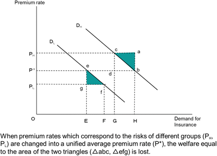
Risk assessment and welfare loss
-
(ii)
Insurance that does not accurately distinguish groups with different risks loses economic fairness.
Principles of fairness would indicate that “people who face the same risk pay the same premium rates, whereas people who face different risks pay different premium rates.” However, if premium rates are not set according to the risks that people face, unfairness occurs between insured groups as shown in Table 21.12. This will result in the withdrawal of the low-risk group from the insurance system and an influx of the high-risk group into it (i.e., adverse selection). In an extreme case, the insurance system itself becomes unable to exist anymore.
Table 21.12 Relationship between insurance premium classification and actual degree of risk
-
(i)
-
2.
Insurance as a social system based on collectivism
Another position considers insurance as a social system based on collectivism. This position views the role of insurance as a method to help people who suffer from accidental events, such as natural disasters, with the spirit of mutual aid within society. This position is based on the concept that society as a group protects itself against unknown risks, as opposed to the concept that insurance is a kind of economic system in which only individuals who pay money can receive benefits according to those payments. Therefore, under this concept, the system should not be one in which only part of the society can participate nor be one from which underprivileged people are excluded. The insurance system should be one in which every member of the society can enjoy the benefits equally. Originally, insurance systems were born as social systems. Then, as techniques of risk assessment developed, the insurance function as an economic system developed accordingly. Viewing insurance as a social system based on collectivism is a position that justifies the income redistribution in the insurance framework in order to give relief to vulnerable people. For this position, underwriting of risk is not needed.
-
3.
The balance between an economic system and a social one
If the underwriting of risk is developed with an emphasis on the insurance system’s economic side, efficient and fair insurance systems can be established. However, when such an emphasis is pursued to an extreme level, there will be concerns that some people will be unable to obtain insurance. When applying this concept to a flood insurance system, the premiums for poor people who tend to live in areas with high flood risks become prohibitively high, and the disadvantaged people are excluded from the insurance system. This is a socially unacceptable situation.
On the contrary, when emphasis is put on the insurance system’s social side and no attention is paid to the economic characteristics, economic welfare will be lost due to the lopsided insurance market, and horizontally and vertically unfair situations will be brought about. In addition, there is another concern that the insurance system might be unable to exist anymore due to adverse selection, in which only those who face higher risks demand insurance. Furthermore, in such a situation, there are some concerns about moral hazard developing among people who live in the dangerous areas, and it may prevent people’s action toward disaster prevention and damage mitigation.
We can consider an insurance system as an economic one or social one. It is a matter of perspective, and the ultimate goal is achieving the best balance possible between the two perspectives. An insurance system which puts extreme emphasis on either perspective will cause serious problems. What is important is what kind of problems we can resolve with insurance and how they can be resolved. That will depend on the specific situation of each community.
-
4.
The UK and France’s perspectives on insurance in the context of land use control for disaster prevention
The UK and France use their own unique insurance systems in their land use management for natural disaster prevention. In the UK, the insurance system is viewed as an economic system and is designed using market principles. On the other hand, in France, the insurance system is viewed as a social system and is designed using the principle of solidarity (solidarité).

Rights and permissions
Copyright information
© 2017 Springer Japan
About this chapter
Cite this chapter
Yoshida, Y., Banba, M. (2017). Flood Disaster Mitigation Measures Through Land Use Management in the UK and France. In: Banba, M., Shaw, R. (eds) Land Use Management in Disaster Risk Reduction. Disaster Risk Reduction. Springer, Tokyo. https://doi.org/10.1007/978-4-431-56442-3_21
Download citation
DOI: https://doi.org/10.1007/978-4-431-56442-3_21
Published:
Publisher Name: Springer, Tokyo
Print ISBN: 978-4-431-56440-9
Online ISBN: 978-4-431-56442-3
eBook Packages: Earth and Environmental ScienceEarth and Environmental Science (R0)