
Abstract
In this chapter, the karst landforms of glaciokarst are presented which are the following: karren , giant grikes , shafts , karst depressions such as giant depressions (dolines , uvalas ), small-sized solution dolines , schachtdolines , subsidence dolines , ponors and poljes . We describe their distribution and frequency, their relation to glacial erosional features as well as the relation between each other, their size, morphology, varieties, evolution, development and development age.
Access provided by Autonomous University of Puebla. Download chapter PDF
Keywords
- Karren
- Giant grike
- Shaft
- Giant solution doline and uvala
- Small-sized solution doline
- Schachtdoline
- Subsidence doline
- Ponor
- Polje
4.1 Introduction
This chapter presents the karst landforms of glaciokarst. These can be features transformed by ice (of preglacial , interglacial and glacial age) and features that were not transformed by glacial erosion (of postglacial age). The majority of features and thus, those being transformed are negative features (karren or karstic depression), but karstic relict landforms also occur among them which are mainly positive features. Pure glacial features and other features of non-karstic origin have already been dealt with in Chaps. 2 and 3 thus, their detailed description is only mentioned where it is necessary for the description of karstic features. On glaciokarst, mainly glacier valleys are being karstified at present. The possible karst features of a glacier valley, their relation to each other and their approximate distribution are presented in Fig. 4.1.

Main features in the glacially transformed karstic high mountains (Veress 2016a, modified). 1. Limestone, 2. older metamorphic basement, 3. till, 4. colluvial debris, 5. fault, 6. siliceous interbedding in limestone, 7. Klippen (plateau), 8. eroded portion of nappe, 9. cirque, 10. trough, 11. roche moutonnée, 12. transverse step, 13. arête, 14. horn, 15. river valley, 16. niche with circular rim, 17. niche of frost shattering, 18. talus cone, 19. path of rock avalanche, 20. furrow of covered karst depression, 21. river, 22. paleodoline, 23. asymmetric paleodoline, 24. paleodoline with moraine, 25. paleouvala, 26. partially filled paleodoline, 27. small-sized solution doline , 28. asymmetric small-sized solution doline, 29. schachtdoline, 30. subsidence doline, 31. subsidence uvala, 32. giant grike, 33. shaft system, 34. passage, chimney, shaft system in cross section, 35. ponor, 36. schichtrippenkarst
The karst features of glaciokarst can be classified and described in many ways. Thus, according to the type of the feature, the development and the development age of the feature, its development environment and its size. In the following, an outline of the features can be found based on the types of the features. We describe their shape and present their morphology, varieties, development age, genetics, size, frequency, distribution and development environment as well as the role of glacial erosion in their development and transformation.
On glaciokarst, based on development age, features being developed in the preglacial , interglacial , glacial and postglacial can be differentiated, while according to their evolution and/or development there are karstiglacial, glaciokarstic , mixed , glacial, covered karstic features, as well as features of mass movement , frost weathering , fluvioglacial , fluvial and snow erosional features. The distribution, the density and the size of various features depend on the degree of the former karstification of glaciokarst and on the nature and degree of glaciation. Karstiglacial features preserved their original state better, while glaciokarstic features and mixed features can be denuded or transformed to various degrees. Adjacent features could even coalesce. However, depressions can be lined, filled or buried too.
Both in the periglacial and temperate fluvial zone, karst surfaces can be covered by superficial deposit. On glaciokarst, based on coveredness, uncovered terrains (bare karst ), terrains covered by soil (soil-covered karst ) and terrains covered by soil and/or debris (till or frost weathering material) may occur (Veress 2016a) . The latter is the covered karst which is cryptokarst if the cover is impermeable and it is concealed karst if the cover is permeable (Veress 2016a). Allogenic karst also occurs on glaciokarst (Veress 2016b). This type develops where there is an impermeable cover on the karst or non-karstic rock becomes wedged in karstic rock and the streams of non-karstic terrain flow towards the karst.
Glacial erosional features and fluvioglacial features can still develop today if the glacial zone is present, while former glacial features and glacial sediments are denuded in the periglacial zone . While in the latter, but also in the temperate fluvial zone, features of snow erosion , features of mass movement and frost weathering features are still developing. On glaciokarst, fluvial geomorphic activity is present to a limited extent (in case of certain karst features and on morainic terrains). Gorges which are widespread on bare karst are exceptions. Their number and density are larger than that of those occurring on karst areas which belong to other karst types. This can be explained by the abundant amount of former (also subglacially , Lepirica 2008) and present meltwater , but the overflowing water of the lakes of glaciokarst also provides favourable conditions for their evolution and development. Glaciokarstic and mixed features are polygenetic (and polymorph ) and since their former karstic development ceased, they are paleokarstic. They reached their present state and form after a long time (the initiation of their development can even precede the Quaternary). Their development was not continuous, it was interrupted from time to time. Their development rate could alternate.
In older karstic features, the nature of younger karstification changes (thus, a ponor develops instead of a doline), the process only affects a part of the original feature, but in this case it may have an effect at several places (for example solution dolines , or subsidence dolines develop in older depressions). Paleokarstic features may also be absent. Either because they did not develop at all or they were destroyed. Their destruction could mainly happen by filling (see below).
The most common paleokarstic features or old features are former solution dolines , uvalas , shafts and poljes . Less common are ponors , karren and remnants features of karst (thus, karst hills and the different types of karstic inselbergs ).
Recent, postglacial features mainly develop in glacial erosional features (in glacier valleys and in the transformed karstic depressions of the floor of glacier valleys), but they also occur on the free glacial erosional surfaces of glaciokarst or on plateau parts exempt from glacial erosion. Some features (for example subsidence dolines ) are more common in paleokarst depressions. However, the characteristics of superficial deposit (thickness, composition) and hydrological conditions (degree and duration of water supply) have a significant effect on the distribution and development of covered karst features. However, subglacial features are often in a perched position (Ford 1996) . The reason for this may be that the meltwater gets into the karst at the higher parts of the floor of the glacier valley or because the subglacial water under pressure leaves the karst at a more elevated part as compared to its entering site (Lauritzen 1986) .
The direct and indirect effects of ice have a different role in the development of the various karst features of glaciokarst. A direct effect is when the meltwater of ice creates the karst feature. Such features can be, for example some karren features or shafts . An indirect effect is when the surfaces (features) or sediments created by ice create a favourable opportunity for karstification . Here again, karren or subsidence dolines can be mentioned as examples. Finally, such a feature development can be mentioned where the glacier or the environment created by the glacier has no role in feature development. Such features can be, for example postglacial solution dolines.
4.2 Karren
Karren are the most typical and most widespread features of glaciokarst. They are mainly dominant in that part of glacier valleys which belongs to the periglacial zone , however, subsoil karren are also present in the fluvial erosional zone of the temperate belt . Regarding their development, karren features are primarily recent (postglacial ) features that developed in the Holocene, but they can also be glaciokarstic features (these karren were partly destroyed by glacial erosion), or they can be mixed , when karren were transformed and partly destroyed to the effect of ice, but they regenerated and continued their development to the effect of meltwater . There is a great opportunity to survive for karren developing along bedding planes (schichtfugenkarren ) and for karren (grike) going transversely the beds being destroyed by glacial erosion and penetrating into the surviving beds (Ford 1996; Rose and Vincent 1983) . Although according to Sauro (2009), large-sized kamenitzas could also survive glacial erosion. However, karren with small depth (rinnenkarren ) are destroyed during glacial erosion.
But karren features could mainly survive because they could continuously regenerate under ice. Thus, because of the continuity of karren formation, although the majority of karren features were partly or completely destroyed because of continuous glacial erosion, karren which developed in the moment of the disappearance of ice survived. Subglacial karren can also become conserved. This occurs when the moraine of the surface is injected into karren features (Ford 1996) .
On karst, karren and epikarst are in a close relationship with each other. Some karst features (grikes ) can form a part of epikarst. This is much more significant on glaciokarst, where meltwater connects the karren and the epikarst. However, this relationship is also expressed by the fact that there is a close relation between the denudation of the surface and the two latter factors too (see Chap. 3). On glaciokarst, karren of glacial age (and their remnants) and also karren of postglacial age such as grikes, pits and schichtfugenkarren can constitute the epikarst.
Karren form karren fields , which are areas of large extension (Bögli 1980) where karren dominate (Monroe 1970) . According to Ginés (2009), limestone pavement is also a type of karren fields. Bögli (1964) differentiates three karst types on glaciokarst: Rundhocker karst (the area of roche moutonnées), Schichttreppenkarst (the bedding planes of horizontal beds) and Schichtrippenkarst (the bedding planes of oblique beds). Since karren dominate roche moutonnées and bedding planes, these karsts are virtually karren fields too.
Karren features of glaciokarst are widespread on erosional features being developed by glaciers (Bögli 1964). They are mainly characterized in troughs and on features that developed in them: mostly on the stepped surfaces of valleys, on the side slopes of troughs, on transverse steps, on the side walls of rock basins, on the side slopes of karstic depressions (Veress 2010) , on roche moutonnées (Veress 2012a; Stepišnik et al. 2010), but they also occur on erratic blocks , on large blocks of moraines (Veress 2010) , on the blocks of rock fall (Djurovič et al. 2010) and on the cemented material of moraines (Žebre and Stepišnik 2015a). However, they can also develop outside glacier valleys, on limestone pavements that were formed by free glacial erosion (Sweeting 1973; Vincent 2009) .
As regards the above-mentioned glacial erosional features, limestone pavements and mainly their parts with bedding planes are the features that experienced karren formation for the most part (Fig. 4.2). The spatial position of surfaces with bedding planes and the surfaces with heads of bed (scarp front) (thus, their dip direction and thus, their position in the valley) and thus, the direction of the expansion of karren terrains were determined by the relation between the direction of ice motion and the spatial position of beds. The expansion and inclination of the terrain with bedding planes and the terrain with heads of bed depend on the thickness and inclination of beds (Fig. 3.32). However, this also depends on the characteristics of the limestone constituting the bed. On the British Islands , those beds have a greater chance to constitute a bedding plane (or such surfaces survive from the former surface), which contain less fractures and in which the rock is more massive (Doughty 1968) . To the joint effect of glacial erosion, karren formation and the stratification of the limestone, the floor of the glacier valley, partly its side (mainly the trough) is a mosaic-like system of surfaces with bedding planes of different expansions, inclination and relative height. The expansion and inclination of some mosaics and thus, that of the bedding planes (the heads of bed too) do not only depend on the thickness and the inclination of beds, but on glacial erosion and on karren formation under the ice too. Therefore, on glacial erosional surfaces (mainly in troughs), karren have a mosaic-like pattern where the expansion of certain karren patches can be extremely different.

A series of steps with karren (valley under Tragl peak , Totes Gebirge, aerial photograph, photo by Kalmár). 1. Bedding plane with rinnenkarren , 2. scarp front, 3. giant grike
The extent and quality of karren formation of bedding planes can be various. Partly because the expansion of the bedding plane determines the amount of water flowing on a bedding plane and partly because soil and Pinus mugo develop on the upper, marginal part of a significant amount of the bedding planes (mainly on the lower parts of the periglacial zone ). The differences are also enhanced by the fact that surficial water flow was partly or completely absent on a number of bedding planes during present karren formation. On the one hand, the reason for this is that the bedding planes are sealed by scarp fronts at many places, by this water flow could become local, on the other hand, because karren features probably already existed following the retreat of ice and the water flowing down the bedding planes passed through them and could get into the epikarst . Karren formation can be various also because the degree of the inclination of adjacent bedding plane surfaces can be extremely different too (see below).
Because of this, the karren formation of bedding planes separating from each other is individual and has karren characteristic features that are only characteristic for it. By this, the number, the density and the kind of karren features of a certain bedding plane differ from the others. However, the bedding planes may have certain characteristics (for example similar inclination and expansion) because of which their karren formation can be more or less similar.
On glaciokarst, four levels of karren phenomena can be differentiated: karren feature , karren assemblage , karren cell , and unit of karren formation .
4.2.1 Glacial Features and Surfaces Bearing Karren
Glacial erosional features are bordered by slopes with various inclinations. These slopes can be put into slope classes with small dip (0°–20°), medium dip (21°–40°), large dip (41°–60°, even 70°) and extremely large dip (71°–90°). Although the karren features of the slopes of various slope classes can also show partial similarity, the karren features of the slopes with various inclination are different (see below). Thus, glacial features show different karren formations if they are bordered by slopes with different inclinations (karren features will be different, but their density may be different too). Therefore, the karren formation of glacier valleys and that of their trough parts as well as that of roche moutonnées is heterogeneous since their slopes have different inclinations. The karren formation of troughs is heterogeneous because their side slopes are steeper than their floor. Heterogeneous karren formation will occur on their floor too if stepped surfaces developed there since they are constituted by bedding planes and heads of bed with various steepness. As the upstream and downstream side slopes of roche moutonnées are bordered by slopes with different steepness (Bennett and Glasser 2009, Fig. 3.4), the karren formation of these features is heterogeneous too.
The inclination of bedding planes depends on the dip of beds (however, the inclination of heads of bed is almost perpendicular to the dip of bedding planes). The bedding planes of beds with small inclination (smaller than 20°), the heads of beds with an inclination of 70°–90°, the slopes of giant dolines (paleodolines), the upstream slopes of roche moutonnées and the roofs of erratic blocks (if they have roofs) constitute slopes with small inclination or they are bordered by such slopes. However, as we will see below, the slopes belonging to the slope class with the small inclination can be put into two subclasses regarding their karren features: the slope subclass with a very small inclination (0°–10°) and the subclass with the less small inclination (11°–20°). The bedding planes of beds with a dip of 21°–40° and the heads of beds with a dip of 50°–69° constitute slopes with a medium dip. The slopes of giant dolines and the upstream slopes of roche moutonnées may be bordered by slopes of such inclination. It has to be noted that beds with a small or medium dip can be areas exempt from compression, but mainly the nappe structures of areas being affected by compression too. The bedding planes of beds with a dip of a 41°–60° (70°), the heads of beds of the beds with an inclination of 20°–49° constitute slopes with large inclination or some parts of the side slopes of paleodolines, the side slopes of rock basins, the side slopes of some glacier valley parts, some transverse steps, the downstream (leeward) slopes of roche moutonnées are bordered by such slopes. Finally, the bedding planes of beds with a large inclination (larger than 71°), the slopes with heads of the beds of beds with small dip (smaller than 19°), the side slopes of glacier valleys, the transverse steps and the side slopes of rock basins constitute slopes with an extremely large dip, or the downstream (leeward) slopes of roche moutonnées and the side slopes of erratic blocks are bordered by such slopes.
4.2.2 The Conditions of Karren Formation on Glaciokarst
The formation of karren is affected by the presence or lack of the cover and the soil, the characteristics of the surfaces created by glacial erosion and snow water.
Even on glaciokarst, karren are not only present on bare surfaces, although the main characteristic feature of this karst type is given by karren that developed on these surfaces. When karren formation does not occur on a bare surface, the cover can be soil, but also moraine (with soil or without soil), frost weathering material or material of mass movements (regarding its distribution, moraine is dominant among the latter ones). While soil stimulates karren formation (see Chap. 2), debris, if it is built up of limestone, hinders dissolution on the bedrock (Williams 1966, and see Chap. 2).
According to our opinion, under soil, mainly grikes (Kluftkarren) and kamenitzas develop. Mainly, kamenitzas can occur in such an environment (on bare surfaces between soil patches) where formation took place under soil, but it denuded later. (Soil denudation can be triggered by climate change, but by human activity too.) The diameter of kamenitzas that developed under soil is large as compared to their depth, the side slopes are of small dip, their margin has a wavy pattern, while the diameter of the kamenitzas of bare surfaces is small as compared to their depth, their side slopes are steep and is separated from the floor, and their margin is arcuate.
Some karren features (kamenitzas, grike, pitkarren ) are formed at the margin of a soil patch (karst is partly covered with soil). In case of various kinds of karren features (rinnenkarren , grike, kamenitza ) it occurs that soil and vegetation are formed in the feature that had developed on the bare surface. Because of this, the whole or some parts of these karren features deepen more intensively. Subsoil karren also occur in the lower part of the periglacial zone (in the so-called dissolutional subzone), but they become predominant in the temperate fluvial zone. Because of soil cover, we only have knowledge of their presence in case of the denudation of soil cover.
We get knowledge of karren developing under moraine if the moraine is denuded. Karren formation under moraine can take place if the thickness of the moraine with limestone material is small or if the moraine thins out (Fig. 2.15) since under moraine with thick limestone material, the bedrock does not become dissolved as the water flowing through the limestone debris becomes saturated before it reaches the bedrock (Williams 1966; Trudgill 1972, 1985). According to Jones (1965) , dissolution also takes place under moraine if there is water with enough acidity which is enabled by CO2 of biological origin. According to Williams (1966), under limestone cover, grikes can only develop on the bedrock if the thickness of bedrock is less than 45.72 cm. According to Sweeting (1973), no dissolution occurs on the bedrock under a calcareous cover with a thickness of more than 2 m. According to Trudgill (1972, 1975, 1985) , the dissolution of the bedrock can take place under such a cover where the pH value is between 4 and 7, the CaCO3 content is below 1%, but the bedrock does not dissolve under such a cover where the pH value is between 7 and 9 and calcareous content is larger than 10%. Karren formation can happen under moraine on a glacially scoured surface. In this case, karren features and glacial striae occur together too (Kunaver 2009a) . Karren formation can also happen in a way that the glacially scoured surface becomes smooth by dissolution. It is probable that water movement of percolation nature is dominant under the moraine and therefore karren features of seepage origin (see below) can develop. Karren features of flow origin are less likely to develop under moraine since the flow is impeded under moraine as a matter of course in addition to this the already developed karren features of seepage origin also hinder water movement.
The karren formation of bare rock surfaces can take place by the effect of flowing water and percolating water too if the water is unsaturated (Veress 2010) . What karren feature is formed on a given bare rock surface basically depends on two circumstances: on the rock structure and the inclination of the bearing slope (in case of some karren features, the dip direction expansion of the slope can be determinant too). It can also be experienced that a certain karren feature type occurs on a surface situated in a certain slope angle dip interval though the capaciousness of an interval can be different in case of various karren feature types.
Karren (rillenkarren , rinnenkarren , meanderkarren , trittkarren , wandkarren ), the longer axis of which coincides with the dip direction of the slope are of flow origin. The features developing during the process are presented in Fig. 4.3. Features of flow origin are called hydraulic forms by White (1988), and hydrodynamically controlled forms by Ford and Williams (2007), while features of seepage origin are called etched forms by White (1988) and fracture controlled forms by Ford and Williams (2007).

Main karren forms on bedding planes truncated by glacier (Veress 2010, modified). 1. Crack, 2. dip direction of the surface, 3. limestone
Karren features of flow origin are mainly formed on surfaces with bedding planes having a smaller or larger expansion, the expansion of which can be some square metres or several hundred square metres too (maybe even some 1000 m2) mainly if the flow is turbulent (Glew -Ford 1980; Trudgill 1985).
Karren features of flow origin develop on surfaces where water flow takes place in a continuous, undisturbed and widespread way. Therefore, the greater the chance for their development is and the larger some karren features are, the more expanded their bearing slope is in slope direction (in the direction of water flow) and the flatter and smoother surface is constituted by the slope. The expansion of a karren feature of flow origin is determined by the expansion of unchanged water flow. No flow develops if the expansion of the slope is small or if the characteristic features of the rocks of the slope hinder flow, but they stimulate percolation. A place that impedes water flow, but promotes percolation in the rock can be the fracture of the rock, the bedding plane (if it intersects the surface), skeletal remnant, calcite fill, debris, the already developed karren feature, the non-karstic rock that intercalated into the limestone (for example siliceous limestone, silica, sandstone).
Among surface-forming factors, glacial erosion is mostly prone to create expanded, smoothed surfaces and thus, surfaces which have undisturbed water flow, and mainly such surfaces that are separated from each other and which have various inclinations. The former surface favours the formation of extensive karren features, while the latter (with various inclination) favours the formation of various karren features. On flat and bare surfaces with similar size and inclination, the degree of karren formation and karren assemblages are considerably similar.
No smoothed surfaces are necessary for the development of karren features of seepage origin (grikes , kamenitza , pitkarren , schichtfugenkarren ). Thus, they also develop at those places where the ice did not create extensive smooth surfaces or where the rock is disrupted with fractures and faults horizontally. In this case, the size and number of karren features mainly depend on fracture density, but the expansion of the bearing terrain also affects the size of karren features of seepage origin. Thus, the length of grikes is determined by the expansion of the bearing surface. However, in this case, the great expansion does not have to coincide with the dip direction. It is common that smooth surfaces with significant expansion are such bedding planes where fault lines with strike direction run. In this case, both karren features of flow origin and those of seepage origin develop adjacent to each other in slope direction below each other on the same terrain part.
On glaciokarst, mainly meltwater enables dissolution that causes the development of karren features. With the increase of altitude, the amount of snow and the duration of melting (and thus dissolution) increases too. The degree of snow accumulation and the local diversity of the duration of dissolution are caused by the exposure, the steepness of the slope, the presence or lack of depressions. The amount of meltwater and the duration of dissolution also affect the fact what karren features develop in a particular place and what their size and density are. There are karren features typically created by snow meltwater. Thus, features are trittkarren (Haserodt 1965) , but the development of wandkarren , schichtfugenkarren and rinnenkarren is mainly caused by meltwater too (Veress 2010) .
4.2.3 Karren Features
Karren features can be classified according to the coveredness of the bearing surface, as well as to their size, morphology (and genetics).
4.2.3.1 Classification of Karren Features According to Size
Bögli (1960, 1976) distinguished karren features that developed on bare surfaces, on surfaces half-covered with soil and on surfaces covered with soil. According to size, there are nanokarren , microkarren , mezokarren and megakarren (Ginés 2009; Grimes 2012) . The width and depth of nanokarren is smaller than 1 mm, those of mikrokarren is below 1 cm. These sizes can extend from some centimetres to some metres in case of mezokarren and from some metres to several ten metres in case of megakarren. On glaciokarst, mainly mezokarren and microkarren are widespread, but megakarren may occur too. For example, such karren can be mentioned from the glaciokarst of Patagonia , where the amount of rainfall is of extreme degree (Veress et al. 2006; Maire et al. 2009) . On the marble surfaces of Diego de Almagro Island megakarren, meanderkarren (Fig. 4.4a), wandkarren (Fig. 4.4b), giant grikes (Fig. 4.4c), and kamenitzas (Fig. 4.4d) are common.

Megakarren on glaciokarst (Diego de Almagro, Chile, photo by Veress). a Meanderkarren , b wandkarren , c giant grike, d kamenitza
On glaciokarst, common microkarren are microgrikes , microspitzkarren and microtrittkarren (Veress and Zentai 2004) . Mezokarren have an even larger diversity which will be presented below. The distribution of microkarren is patchy, they mainly occur on terrains that became exempt from ice a short time ago (Veress and Zentai 2004) . Mezokarren are more widespread than microkarren.
4.2.3.2 Classification of Karren Features According to Shape and Development
4.2.3.2.1 Karren Features of Flow Origin
Rillenkarren are constituted by features that are of great density, some centimetres wide and deep and some tens of centimetres long features with slope direction, but they wedge out in slope direction (Fig. 4.5). They develop at the upper margin of the slope under sheet water , where turbulent water flow develops to the effect of raindrops (Glew and Ford 1980) .

Rillenkarren (Totes Gebirge, photo by Veress). 1. Destroying pit, 2. rillenkarren , 3. grike
Rillenkarren are cosmopolite karren which occur on almost every bare slope, their development is mainly patchy (the expansion of the patches rarely exceeds 1 m2 though the size of the patches can be very diverse in some places). “Ausgleichsfläche ” usually develops below the zone of rillenkarren which is a flat, small-inclined surface smoothed by dissolution where the intensity of dissolution decreases (Bögli 1960). Corrosion terraces (Kunaver 2009b) , and flachkarren (Veress 2010) are larger, but locally expanded, horizontal and flat, hardly dissected surfaces (Fig. 4.6). The latter bear different karren features (nischenkarren , kamenitza , meanderkarren ).

Channels on a flachkarren (Totes Gebirge, Veress et al. 1995). 1. The place of theodolite, 2. contour line in local system, 3. the depth of the form (m), 4. nischenkarren , 5. type I channel or channel in general, 6. type II channel, 7. type III channel, 8. kamenitza , 9. pit in general, channel end pit, 10. channel-bottom pit, 11. wreck pit at the bottom of a channel, 12. entrance of spring karren cave, 13. through karren cave, 14. shaft, 15. grike 16. griant grike
Rinnenkarren (channels or runnels ) are grooves with slope direction (Figs. 4.6, 4.7 and 4.8), the width and depth of which can spread from some centimetres to 1–2 m, their length can be some metres or several ten metres (Ford and Williams 2007; Veress 2009a) . They have no surface drainage as they are connected to pits and grikes . They are formed under rivulets which develop by the splitting of sheet water (Trudgill 1985; Ford and Williams 2007). On the bare slopes of glaciokarst, they occur in a large (up to several 100 m2), adjoining expansion (Fig. 4.2). Their varieties are rundkarren, decantation channels , type A and type B channels, rinnenkarren systems , type I, II and III channels (Ford and Williams 2007; Veress 2010; Veress et al. 2015) . The ridges between the channels of rundkarren became rounded by dissolution (Fig. 4.8). Rounded ridges prove that dissolution took place under the soil cover. Soil cover is temporary (Haserodt 1965; Veress 2010) or these features were always under soil and thus, they developed under the soil, but they exposed because of soil denudation (Bögli 1976). Decantation runnels are unique, solitary features that originate from point-like water supply places (for example kamenitza ) (Fig. 4.9, Ford and Williams 2007) . Type A channels are rinnenkarren with V-shaped cross section and a small size and have a small specific catchment area (the catchment area calculated to the 1-m length of the channel, which can be calculated from the quotient of the total catchment area of the channels and of the channel length) which have no tributary channels. Type B channels are karren features with a U-shaped cross section, they are larger and their specific catchment area is larger, which have tributary channels. Rinnenkarren systems are channel systems having type B main channels larger than the previous ones and having several type A and/or type B tributary channels (Veress et al. 2015, Fig. 4.7) . The majority of rinnenkarren is given by type A and type B channels and rinnenkarren systems. According to their size, three channels can be distinguished: larger channels, being several tens of centimetres wide and deep (type I), smaller channels, the width of which is smaller than ten centimetres (type II) and even smaller channels which are some centimetres wide (type III) (Veress 2009a, Fig. 4.10).

The karren features of a part with bedding plane (Totes Gebirge, photo by Veress). 1. Bedding plane, 2. scarp front, 3. channel-bottom pit, 4. channel end pit, 5. main channel, 6. grike, 7. tributary channel, 8. channel system

Semi-exhumated rounded rundkarren (Totes Gebirge, at Vd. Lahngang Lake, photo by Veress )

Kamenitza and decantation channel (photo by Veress). 1. Kamenitza , 2. decantation runnel, 3. channel with an opened up karren cave on its floor

The morphological complexes of different parts of a channel (Veress 2009a, modified). a, b Upper parts of the channel, c, d middle parts of the channel, and e lower part of the channel 1. line of dip of surface
Meanderkarren are channels with asymmetric cross section (Veress and Tóth 2004; Veress 2009b) . The asymmetric cross section goes with the meandering ground plan of the feature only in the case of looping meanders (Fig. 4.11a). In case of other meanderkarren types the channel has a straight margin. The steep (often overhanging) and gentle slopes causing asymmetry alternate on the channel: the steep side is followed by a gentle one, then by a steep side again on the same side of the channel. Such karrenmeander types are the remnant meander (Fig. 4.11c), the developing meander (Fig. 4.11b) and the perishing meander (Veress and Tóth 2004; Veress 2009b) . The asymmetric cross section is caused by the fact that the channel line of the water running down on the present or the former floor of karren meander was meandering or is meandering. The side of the feature will be steeper, where dissolution is more intensive. This occurs in case of faster water movement thus, where the channel line gets closer to the side wall during its meandering (Veress 2009b) . [According to Dubljanszkij (1987), faster flow maintains the concentration difference between the boundary layer and the flowing water and thus, it enables the transport of Ca ion.] The spread of karren meander is unique and they do not develop in a continuous way.

Meanderkarren: loop meander (a) and developing meander (b), remnant meander (c) (photo by Veress). 1. Composite skirt, 2. partly detached skirt (karren “inselberg”), 3. symmetrical meanderkarren part (without skirt and overhanging wall), 4. asymmetrical meanderkarren part (with skirt and overhanging wall), 5. overhanging wall, 6. gently dip wall (skirt), 7. notch
Wandkarren, (Fig. 4.12) are parallel channels with half-cylindrical or trapezoid cross section (Veress 2009c, 2010) . They develop under the water that is flowing down the steep slope: wandkarren which are situated densely, are of smaller size, having a half-pit cross section and being rillenkarren -like develop under sheet water , while those occurring less densely, having a larger size and trapezoid cross section and being rinnenkarren -like are formed under a rivulet (Veress 2009c, 2010) . While their width and depth are between some centimetres and some tens of centimetres, their length is some metres or several ten metres. Wandkarren are not closed and not areic features. They are common karren features of steep slopes and develop in high densities and continuously. Their expansion is extremely variable at a given place. The area of the slope covered with wandkarren can be some m2 or several hundred m2.

Wandkarren (valley side under Tragl peak , Totes Gebirge, photo by Veress). 1. Wandkarren , 2. schichtfugenkarren
Where the continuity of the rock is interrupted, for example at places where the surfaces being cut by ice are intersected by bedding planes (Fig. 3.34), small-sized passages with a diameter of some centimetres develop on the floors of rinnenkarren which drain the water of channels underground. These features are the karren channel swallets which continue in passages or in swallet karren caves (in karren caves) being some metres long (Veress 2010, Fig. 4.10) . The percolating water also has a role in their development. Karren channel swallets convey the water flowing into the rinnenkarren into the karst. This water results in the development of karren channel caves first in a seepage way then in a flowing way. Karren channel swallets and swallet karren caves are unique and rarely occurring karren features.
Trittkarren are circular features with a diameter of some tens of centimetres (or maybe some metres), which are built up of two parts: the steeper riser with an arcuate pattern in plan view and the tread with a smaller inclination and near-circle ground plan (Bögli 1951; Veress 2009d, 2010) .
The trittkarren of the increasingly steeper slopes have an increasingly higher riser, but their tread will be of increasingly smaller expansion (Fig. 4.13, Balogh 1998) . The varieties of this karren feature are the typical trittkarren (Fig. 4.13b), the nischenkarren (Fig. 4.13a), the trittkarren uvala (Fig. 4.13b) and the trichterkarren (Haserodt 1965; Veress 2009d) . The typical trittkarren has a tread and a riser. The common tread of trittkarren uvalas is surrounded by a riser built up of several arches. The wide tread of nischenkarren with an expansion of 1–2 m is surrounded by a wavy and arcuate riser with a small height (1–2 cm). The trichterkarren has a well-developed riser, but it does not have a tread. Trittkarren occur in patchy expansion only on a surface with bedding planes (the area of the patches is not large, only some m2), however, typical trittkarren occur there in groups, in large density.

Nischenkarren on a slope with a smaller dip (a), typical trittkarren on a slope with a larger dip (b) (photo by Veress). 1. Rillenkarren , 2. typical trittkarren , 3. trittkarren uvala, 4. typical trittkarren with a small riser, 5. Nischenkarren
4.2.3.2.2 Karren Features of Seepage Origin
Grikes (Fig. 4.5) are features with a width of some tens of centimetres, their depth is 1–2 dm and 1–2 m, their length is several 10 m, their side wall is vertical and their margin is straight. Typical grikes occur in groups, the distance between the depressions is 1–2 dm, and the depressions are parallel to each other. The expansion of terrains with grikes can also exceed several 100 m2. One of their varieties is the lattice-like karren when the grikes develop in two directions being perpendicular to each other (Fig. 4.14). Grikes develop to the dissolution effect of the water percolating along fractures (Sweeting 1966; Goldie 2009) , but they can also develop along vertical bedding planes. The directions of the grikes of bedding planes mainly coincide with the strike direction of bedding planes (Veress 2010, Fig. 4.7). Probably because the widening of fractures with strike direction is more intensive than that of fractures with dip direction. The reason for this is that the fractures with strike direction cross water flow and thus, they can get water, however fractures with dip direction do not cross water flow, water flows passing them thus, they get less water. Giant grikes which can be regarded as megakarren have several varieties according to their development, and therefore, this feature is presented in a separate chapter.

Lattice-like karren (Totes Gebirge, photo by Veress)
Kamenitzas are basin-like karren with a circular ground plan (Fig. 4.9). Kamenitzas with a diameter of several metres and even several ten metres occur for example on the Diego de Almagro Island (Veress et al. 2006) . On the floor of large kamenitzas, other karren features with smaller size may develop too, such as karren channel swallet, rinnenkarren and trittkarren (Veress 1995; Veress et al. 2006). The density of kamenitzas is not large, they mostly occur alone, one by one with other karren features together.
Pitkarren are vertical tubes with a diameter of some centimetres and some tens of centimetres. Their vertical size can be some decimetres or some metres. They occur in groups (Fig. 4.15) or alone on the floor of other karren features (for example rinnenkarren ) (Fig. 4.7). Their occurrence in groups is not common. The expansion of terrains with pitkarren is only of some m2.

Pitkarren (Totes Gebirge, photo by Veress)
Schichtfugenkarren are features with a height of some centimetres or some tens of centimetres (Figs. 3.23, 3.29 and 4.12), which develop by dissolution along bedding planes. Their longitudinal expansion can be several 10 m. They most often occur with wandkarren together. Based on the number of bedding planes outcropping on the rock walls of valley sides, several schichtfugenkarren can also develop above each other. However, they can occur on shaft walls and grike walls too. On grike walls they were formed following soil development if the grikes are not inherited. Or they developed at the soil surface or under the soil surface where the water percolating laterally reaches the bedding planes of the rock.
Among the characteristic karren features of glaciokarst can also be mentioned the relict landforms such as arches (Veress 2010), relict ridges or tail-dune karren buttes on the leeside of rock blocks (Veress et al. 2006, Fig. 2.12) and karren tables (Bögli 1961). Arches are relict features above windows that develop with the coalescence of adjacent karren features. Tail-dune karren buttes are formed at those places, where the surface does not dissolve at the leeside of rock blocks (Veress et al. 2006; Maire et al. 2009). Karren tables develop at places where the surface dissolves everywhere around the rock blocks except under them (for example moraine) (Bögli 1961).
4.2.3.3 Karren Features of Glacial Erosional Surfaces and of Glacial Erosional Features
The development environment of karren features is given by the inclination and expansion of the bearing slopes. In Chap. 3, it has already been presented that the expansion of surfaces with bedding planes that developed by glacial erosion (and those of the scarp fronts too) depends on the inclination of the beds and on bed thickness. (Thus, also in the case of beds with the same inclination, their expansion in dip direction can be extremely different.) Since the development of some karren features also depends on the expansion of the slope (rinnenkarren , wandkarren ), in case of the same inclination they can only develop if the bearing slope is wide enough in the dip direction. In the following, the development environment of different karren features are presented. The karren feature assemblage of the surfaces and features that are developed by glacial erosion can be described by this.
Rillenkarren occur on slopes with an inclination of about 10°–65°. Accordingly, they are mainly specific to both on bedding planes and on heads of bed, but they can also develop on roche moutonnées. Since they are also formed on slopes with an extremely small width, they can be present not only on glacial erosional features, but also on moraine blocks, on the blocks of falls and on the slopes of karren features (for example on the riser of trittkarren ).
According to measurements carried out on slopes with bedding planes (Veress et al. 2015), type B channels occur on slopes with small inclination, smaller than 45°. Their density decreases with the increase of the inclination of the bearing slope. With the decrease of slope inclination, type B channels will be more complex and their total length increases too. In case of an inclination smaller than 20°–25° rinnenkarren systems become significant (Veress et al. 2015). The density of type A channels increases with the growth of slope inclination until 60° and their density exceeds the density of type B channels at an inclination of 30° (Veress et al. 2015). However, they do not occur on slopes with an inclination larger than 60° at all. Rinnenkarren mainly develop on the bedding planes of troughs (Fig. 4.2). Among them, type B channels develop on the bedding planes of beds with a smaller dip if the expansion of these surfaces is several metres in dip direction (5–10 m or even larger). Rinnenkarren systems develop in dip direction on bedding plane slopes with a width of several 10 m and with a small dip. Type A channels can also develop on bedding planes with a width of some metres and small expansion situated on beds with a larger dip. The larger dip of the beds is and the thicker the beds are, the bigger the chance is that type A channels develop on scarp fronts (on heads of bed) too. Rinnenkarren systems can also develop on the gentle side slopes of giant dolines , but they can also be formed on the upstream slopes of roche moutonnées (however, type B channels can be present too). Type B channels and rinnenkarren systems develop on such surfaces where thick beds were cut by glacial erosion (Fig. 3.34) since between the bedding planes there may be relatively wide surfaces where water flow is continuous too.
Meanderkarren develop on slopes with a dip smaller than 10° and thus, they occur on the bedding planes of almost horizontal beds. However, they can develop on unstratified rock (for example on the marble karst of the Diego de Almagro Island ), where glacial erosion did not create stepped terrains, but it formed plain surfaces of small inclination.
Trittkarren are widespread on very smooth surfaces with an inclination of 0°–40°. Their type and morphology changes with the increasing dip. Especially on a horizontal slope (the dip of which is smaller than 5°–10°), if it is widespread (several metres), nischenkarren develop. With an increasing dip of the bearing terrain typical trittkarren develop, the riser of which increases with the increasing inclination of the bearing slope. The frequency of trittkarren groups decreases on slopes with a larger inclination. Trittkarren occur on the small-inclined bedding planes of troughs, on Flachkarren, on corrosion terraces and on the upstream sides of roche moutonnées.
On slopes with an inclination larger than 70°, wandkarren are formed. According to our measurements, they can occur in large densities even on slopes with a dip of 85°. Wandkarren are widespread on transverse steps, on longitudinal scarps, on the side slopes of rock basins, on the side walls with the head of bed of shaft walls, on moraine blocks, but mainly on the side slopes of glacier valleys. Wandkarren often develop on heads of the bed, which are surrounded by Schichtfugenkarren mainly if the beds are thick (2–4 m).
Grikes mainly develop on horizontal surfaces. Lattice-like karren are exclusively characteristic of slopes with an inclination smaller than 10°. With the increase of slope inclination, their density decreases, but grikes even occur on slopes with an inclination of 31°. Grikes being formed along fractures develop on bedding plane surfaces of beds with small dip and being not so thick, while those grikes which are formed along bedding planes develop on the surfaces of hogbacks constituted by beds with a large inclination (close to 90°). Therefore, grikes are specific of the floor of troughs where the beds are horizontal or of small dip (on the bedding planes of stepped surfaces) or they are almost vertical (on the heads of bed of hogbacks).
Solitary pits or those forming groups develop on slopes with a small dip (at most 30°). First of all, they develop on bedding planes with a small dip mainly on horizontal bedding planes of troughs.
Kamenitzas occur on the small-inclined slopes of troughs (mainly on slopes with an inclination of 0°–10°, at most 38°). Thus, they can be found on the bedding planes of beds with a small dip, at the roof level of roche moutonnées, or rarely on the downstream slopes of roche moutonnées (where the surface is less uneven). However, they can also appear on the flat terrains between roche moutonnées like on the Diego de Almagro Island (Veress et al. 2006) .
The density and the frequency of occurrence of karren features of seepage origin decreases with the increase of slope inclination. However, with the exception of lattice-like karren , they increase on slopes with an inclination of 21°–30° as compared to slopes with a dip of 11°–20°. A probable cause of the local increase of density is that the fractures of the rock (their maturity and density) may modify the role of slope inclination in their development.
Schichtfugenkarren develop on slopes with an inclination of 70°–85°, where the dip direction of the beds is opposite the dip direction of the steep (but not vertical) slope that developed by glacial erosion. Mainly, if the beds are thick and wandkarren are aligned on the heads of bed. Such places are the slopes of troughs, rock basins and transverse steps.
We have already mentioned that among surface landforms being created by ice, glacier valleys, stepped surfaces and roche moutonnées show karren formation heterogeneity. The most different karren formation (karren features are different) can be experienced between the side slopes of troughs and their floor. On their steep-side slopes, wandkarren and schichtfugenkarren are characteristic. The karren features of the stepped surfaces of more gentle side slopes and of valley floors are significantly different from the karren features of steeper side slopes. Thus, rinnenkarren , meanderkarren and kamenitzas are predominant. Though the floor of the valley (especially that of the trough) is in itself complex: stepped surfaces, steps, rock basins, roche moutonnées, moraine (mountains falls) blocks and dolines may alternate. Therefore, individual erosional features (stepped surfaces, roche moutonnées) show karren heterogeneity in themselves too.
On the bedding planes of stepped surfaces, a variety of karren features (Figs. 4.2 and 4.16) can be present, karren assemblages according to environment are widespread, karren cells and karren formation units are common (see below). On the contrary, few karren feature types develop on scarp fronts (wandkarren and schichtfugenkarren ), their size is small, their density is only locally large, their distribution is not continuous. On scarp fronts, karren do not constitute karren cells.

Varieties and karren assemblages of stepped surfaces. i Bedding planes and scarp fronts that developed in case of large bed thickness and very small (a), less small (b) and medium (c) bed inclination, ii bedding planes and scarp fronts that developed in case of small bed thickness and very small (a), less small (b) and medium (c) bed inclination. 1. Bed, 2. fracture, 3. bedding plane, 4. scarp front, 5. grike, 6. nischenkarren , 7. typical trittkarren , 8. karrenmeander, 9. wandkarren , 10. Schichtfugenkarren, 11. rillenkarren , 12. „Ausgleichsfläche”. 13. giant grike, 14. kamenitza , 15. rinnenkarren system, 16. type B channel, 17. type A channel
Since roche moutonnées are positive features, their karren formation is unique and specific. Karren features often enclose the top of roche moutonnées and if they are of flow origin, they are divided into branches radially mainly from the soil or vegetation patches being formed at the roof level (Veress 2012a). This structure proves the dissolution effect of soil and vegetation patches on bare surfaces. The karren formation of the upstream slopes of roche moutonnées (which is a plain slope with small inclination) resembles the karren formation of slopes with bedding planes to a great extent. At these places, features of flow origin such as rinnenkarren are common (Fig. 4.17a). However, the size and/or density of the features are smaller than that of the surfaces with bedding planes . On the lee side (the downstream slope) which is short and often dissected, few karren feature types occur (kamenitza and grike) and their density and size are small (Fig. 4.17b).

Karren formation of a roche moutonnée (valley under Hetzkogel , Totes Gebirge, photo by Veress). a karren features of the upstream side, b karren features of the lee side; in photo A (top left) the upstream side of a roche moutonnée, (bottom right) the lee side of another roche moutonnée
The karren formation of other glacial erosional features or features transformed by glacial erosion is less significant, it is discontinuous and usually, only some karren features are present. The side slopes of giant dolines are often covered by debris thus, either no karren developed on them at all or if they did, they become covered. If karren develop on the side slopes of giant dolines, they are mainly of flow origin. Thus, rinnenkarren develop which converge towards the direction of the doline floor (Fig. 4.18). The karren features of the blocks of moraines or of mountain failures occur sporadically, their karren formation is not continuous, it is dispersed (Fig. 4.19).

Karren features of the side slope of a giant doline: rinnenkarren systems are predominant (Totes Gebirge, photo by Veress)

Wandkarren of a moraine block (near Simonyi Hütte in the valley of Hallstatt glacier, Dachstein, photo by Veress )
4.2.4 Karren Assemblages
On karren terrains, systems built up of various karren features are called karren assemblages . Bögli (1976) was the first to describe karren assemblages . Karren can constitute functional karren assemblages and karren assemblages according to the development environment . In case of the former ones, those features constitute the karren assemblage where water flows (or can flow) from one feature into the other. In case of karren assemblages of development environment, those features create the karren assemblage which occurs together on slopes with a similar inclination.
Within functional karren assemblages , Veress (2010) differentiated grike-rinnenkarren assemblages , rinnenkarren-grike assemblages , rinnenkarren-pit assemblages , rinnenkarren-giant grike assemblages , wandkarren -schichtfugenkarren assemblages , pit-grike assemblages and grike-schichtfugenkarren assemblages . In the case of grike-rinnenkarren assemblage, first rinnenkarren were formed, then grikes developed since grikes intersect the majority of rinnenkarren. However, in the case of rinnenkarren-grike assemblage, first grikes developed since rinnenkarren terminate at grikes and they do not continue over them. In the case of rinnenkarren-giant grike assemblage, giant grikes may occur inside the same terrain with bedding planes or at the foot of the step bordering the bedding plane. If the giant grike is situated inside a given bedding plane, there is often a small step (karren step) of 1–2 dm at the margin of the grike which falls in the dip direction of the surface that is inclined in the direction of the joining rinnenkarren. Its sizes (either the vertical or horizontal sizes) are significantly smaller than the sizes of the steps of stepped surfaces. The pit-grike assemblage exclusively occurs at the foot of stepped surfaces.
According to the development environment, on glacial erosional features and on their slopes the following karren assemblages can be differentiated (Fig. 4.16).
Among surfaces with a small dip (0°–20°) some surfaces with a dip of 0°–10° and with a relatively larger expansion are Flachkarren where nischenkarren , kamenitzas, meanderkarren and grikes can constitute karren assemblages on plain surfaces with a small dip. Such karren assemblages occur on those parts of troughs, where the dip of the bed is smaller than 10°. The karren formation of these surfaces can often be of two kinds. In the case of one kind, meanderkarren, various trittkarren (mainly nischenkarren) and rinnenkarren being wide as compared to their depth are predominant. This variety develops if water percolation is restrained on the bedding plane, there are no fractures (or their frequency is low), the precipitations of the former meltwater may create a crust on the surface of the bedding plane. In the case of the other variety, fracture density is large in the rock and in this case mainly grikes and lattice-like karren develop.
On surfaces with an inclination of 11°–20° and with an expansion of several metres or even several tens of metres in slope direction, rillenkarren , rinnenkarren systems , typical trittkarren , meanderkarren , kamenitzas, pitkarren and grikes can constitute the karren assemblages . These karren assemblages are widespread on the terrains with bedding planes of troughs, where the dip of the bed is 11°–20° and on the side slopes of paleodolines and roche moutonnées with such an inclination.
On surfaces with an inclination of 21°–40° and with an expansion of several metres or even several tens of metres in slope direction, rillenkarren , type B channels or maybe rinnenkarren systems , type A channels, grikes , trittkarren and kamenitzas can constitute the karren assemblages . (All types of the above-mentioned karren features are very rarely present together.) These karren assemblages occur on those terrains with bedding planes of troughs where the dip of the bed is 21°–40° and on those side slopes of paleodolines and roche moutonnées where the surface inclination is 21°–40°.
On surfaces with an inclination of 41°–60° (70°) and with an expansion of some metres, rillenkarren and type A channels can constitute the karren assemblages . These surfaces are the terrains with bedding planes of troughs where the dip of the bed is 41°–60° and those heads of the bed where the dip of the bed is 30°–49°, but also the slopes of those paleodolines and roche moutonnées where such an inclination occur.
On surfaces with a dip of 71°–90°, wandkarren and schichtfugenkarren can constitute the karren assemblages . Such slopes can constitute the side slopes of glacier valleys, the side slopes of steps and rock basins, the shaft walls and the walls of giant grikes .
Karren features are the most diverse on slopes with an inclination of 11°–20° and 21°–40°. Its significance is expressed by the fact that the existence, growth and coalescence of many karren features favour the denudation of limestone beds. Rinnenkarren systems (mainly on slopes with an inclination of 11°–20°), type B channels and grikes occur on these slopes. Thus, on slopes belonging to the above-mentioned categories, there is a possibility for the formation of grike-rinnenkarren , rinnenkarren-grike and rinnenkarren-giant grike assemblages . Mainly, these karren assemblages and grike-schichtfugenkarren assemblages (or the karren constituting them) contribute to the denudation of limestone.
4.2.5 Karren Cells
A karren cell is a morphologically closed, areic karren terrain of a surface with bedding planes (Veress 2010). Karstic water drainage takes place from its area, usually through pits. On a surface with bedding planes, several karren cells can be present which are separated from each other hydrologically and their karren features can be the same, but different too. On the area of karren cells, most often rinnenkarren , grikes and pitkarren occur (rinnenkarren-pitkarren and rinnenkarren-grike assemblage).
4.2.6 Karren Formation Units
By a karren formation unit, we mean the karren surface of a slope (Fig. 4.20) where rinnenkarren and grikes are predominant, but several other karren features may occur too (kamenitzas, rillenkarren , meanderkarren , trittkarren , pitkarren ). However, not only karren features are present on the karren formation unit, but also giant grikes , schachtdolines and shafts too. On glaciokarst, they mostly developed on the bedding planes of stepped surfaces (Fig. 4.20). Their expansion coincides with the expansion of the bearing surface with bedding planes. They have a large expansion if the given bedding plane has a large expansion too. This is valid if small-inclined terrains built up of thin beds were destroyed by glacial erosion (see Chap. 3). The karren formation unit is dissected by karren cells of different maturities and expansions and karren assemblages may be repeated in their area where several water drainage places can exist.

A karren formation unit dominated by rinnenkarren systems (valley under Tragl peak, Totes Gebirge, aerial photograph, photo by Kalmár). 1. Bedding plane, 2. scarp front, 3. giant grike
4.2.7 The Degree of Karren Formation of Glaciokarstic Surfaces
The degree of karren formation of a terrain can be determined by the density and specific width of karren features occurring there (Veress 2010). The specific width is the average width of the measured karren features on a given length (along a profile, the selection of which takes places accidentally) calculated to 1 m, which can be determined if we divide the total width of the karren features occurring along the profile by the length of the profile.
In order to determine specific width data, the necessary profiles were created mainly on the surfaces with bedding planes of the glaciokarstic areas of the Alps (in the pine tree zone, in the Pinus mugo zone and on bare surface) (Veress 2010). The data represent the karren formation of surfaces with bedding planes. Both in the pine tree zone and the Pinus mugo zone, there were profiles with soil and vegetation patches and there were profiles which lacked them. However, this only reflects the momentary state at the measurement places. Since the initiation of karren formation, vegetation may have developed on the current bare slope (but the vegetation patch could be destroyed), while the current bedding plane with vegetation patches could also be bare at the beginning of karren formation.
However, in order to determine the actual (complete) karren formation characteristic features, the data of the terrain parts covered with soil or moraine should also be taken into account. But the data of the karren features of covered terrain parts are unknown. Thus, the data on the degree of karren formation described below only contain the data of bare surfaces. This does not contain the data of karren features occurring on all bare surfaces either. No measurements were carried out in case of small karren features (rillenkarren ), those hard to access (wandkarren , schichtfugenkarren ) and in case of karren features which occur very rarely (karren cave). However, because of inheritances, the values of dissolution (represented by specific widths) could not only develop under the present environmental circumstances.
According to Veress (2010), the density of karren features decreases by the increase of altitude. In the Alps , the average density along profile is 0.41 piece/m on the bare surfaces of the pine tree zone, 0.37 piece/m on the bare surfaces of the dwarf pine tree zone (Pinus mugo ) and 0.26 piece/m in the vegetation free zone (partly the area of alpine meadow). If we consider the specific widths, it can be established that two kinds of karren features are predominant: rinnenkarren and grikes (Fig. 4.21, Veress 2010) . The specific width of rinnenkarren is larger in the Pinus mugo zone, while the value of grikes is larger in the pine tree zone (Fig. 4.22). Therefore, grikes (or karren formation represented by them) are more dominant in the pine tree zone. Here, grikes developed by dissolution under the soil (disregarding those which were inherited from glacial and under soil cover they only continued their development) then they were exposed at the surface following the denudation of the soil. This is also proved by the fact that soil and vegetation are always present on the floor of the grikes of this zone. In the pine tree zone, the development of rinnenkarren was also possible preceding soil formation (rinnenkarren that developed at this time are the present rundkarren). However, they could also develop on bare surface uncovered with soil or when bare surfaces developed because of soil denudation (which can be caused by human activity too). (From the glacial, only those rinnenkarren could be inherited which existed during the disappearance of ice cover. Those that had developed earlier were destroyed during glacial erosion because of their small depth.) In the Pinus mugo zone, the larger specific width of rinnenkarren is possible because here bare surfaces permanently survived after the retreat of ice where there were favourable conditions of water flow. At the same time, bare surfaces can also get CO2 of soil origin from soil and vegetation patches, which can increase the intensity of dissolution (Veress 2012b).

The degree of specific width which refers to different karren forms by using data of profiles of valley of Triglav Lakes , Totes Gebirge, and Dachstein (Veress 2010, modified). 1. Rinnenkarren , 2. grike, 3. pitkarren , 4. trittkarren , 5. kamenitzas

Specific width with total value (a) and values belonging to various kinds of karren forms (b) in various plant belts (Veress 2010, modified). 1. Pine belt, 2. Pinus mugo belt, 3. bare belt (1–2–3 valley of Triglav Lakes, Totes Gebirge, Dachstein), and 4. Pinus mugo belt (Asiago Plateau)
4.3 Giant Grikes
The depth and width (mainly the depth) of giant grikes can exceed several metres, while their length can exceed even several hundred m (Fig. 4.23). They are often inherited to the cover too (Fig. 4.24). Giant grikes are common features on other karst areas, mainly on tropical karst (Grimes 2012; Ford and Williams 2007) . However, they do not often occur on glaciokarst and in contrast with tropical karsts where they occur in groups, they are solitary forms. They are widespread both in the glacial and periglacial zone of glaciokarst. Ford (1984) mentions these features as solution corridors. On Nahanni karst (Canada ), since they occur in large numbers, labyrinth karst develops (Brook and Ford 1978) . They are described in a separate chapter as their development differs from grikes.

Giant grikes (Totes Gebirge, a, b, photo by Veress)

Giant grikes with various morphological environment inherited over the superficial deposit (photo by Veress). a In a cirque (cirque under Triglav ), b in a trough (Todorov valley , Durmitor ), c in a giant doline (Totes Gebirge). 1. Anti-dip step (roche moutonnée), 2. covered karst of a cirque, 3. debris cone, 4. giant grike (covered with debris in photos a, b), 5. shafts , 6. suffosion dolines
Grike walls are often divergent downwards. Various mezokarren features can occur on the walls (rillenkarren , wandkarren Fig. 4.4c). Those with a smaller (some tens of centimetres) width can be dissected by pits (Fig. 4.7) and shafts (Fig. 4.25). In case of grikes with pits, the pits are coalesced to a various extents, rinnenkarren are connected to them from the surrounding terrain with bedding planes. Giant grikes can develop on the floor of cirques (Fig. 4.24a) or on the floor of troughs (Fig. 4.24b), in karstic depression (Fig. 4.24c) at the scarp fronts of stepped surfaces (Fig. 4.26), but on bedding planes (Figs. 4.2 and 4.25) too. The longer ones can intersect a series of bedding planes and scarp fronts (Fig. 4.24b).

Giant grike with a shaft (valley under Tragl peak , Totes Gebirge, photo by Veress)

Giant grike that developed by the confluence of the water of grikes (Julian Alps , valley of Triglav Lakes, photo by Veress)
According to their position, they can be longitudinal and transverse. The longitudinal ones are parallel to the direction of the trough (Figs. 2.14 and 4.25) or to the dip direction of the bedding planes (Fig. 4.25), while the transverse ones are perpendicular to the direction of the valley (Fig. 4.24b) and to the dip direction of the bed. Giant grikes are mostly straight in plan view, but those located along scarp front can be winding or saw-toothed. According to their cross section, there are symmetric and asymmetric giant grikes . In the case of the latter ones, which are mainly characteristic of those situated at scarp fronts, the side with the head of bed is longer than the slope on the side from the bedding plane. According to Ford (1984) , giant grikes developed by subglacial dissolution. According to development, their main varieties are the following:
-
Coalescing giant grike : it develops with the dissolution of the dividing walls of adjacent grikes or pits.
-
Connecting giant grike : grikes connecting in dip direction create a larger feature (Fig. 4.26). Such giant grikes are formed in the area of bedding planes. Their development is enabled by the confluencing water of grikes.
-
Polygenetic giant grike : the grike is wide, often partially filled with debris (Fig. 4.27). On the floor covered with debris, shafts and subsidence dolines may occur, on the scarp fronts there may be opened up (partially destroyed) cavity remnants. The grikes of this type probably developed by the coalescence of pits or maybe of shafts and then they widened by the frost weathering denudation of the scarp front. The debris is partially transported into the karst in which the fact also has a role that the channels (rinnenkarren ) of the slopes with bedding planes transport water to the grike.
Fig. 4.27 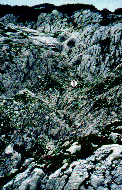
Giant grike at scarp front (Totes Gebirge, photo by Veress). 1. Subsidence doline
-
Corridor on the dividing wall : corridors formed on the dividing wall between dolines may also belong to the group of giant grikes (Fig. 3.19). Their development is also complex and takes places to the effect of several factors (see Chap. 3.1.2).
-
Meltwater giant grike : grikes belonging to this variety develop on the floor of troughs. Their development under present circumstances is not possible since they do not receive enough water for this. Therefore, they were formed to the effect of meltwater under the ice (Ford 1984) .

4.4 Shafts
Transitional features can be put among surface and subsurface features of glaciokarst. Their common characteristic feature is that they have a sharp margin, they do not have a catchment area and they are often in a perched position as compared to their environment (Figs. 4.25 and 4.28). They have a vertical position and extend deep into the vadose zone . They are specific of the glacial and periglacial zone , but they may occur in the fluvial zone of the temperate belt too, and also on other karst types. The development of the shafts of the karst is explained by the dissolution effect of the sheet water which takes place on fault planes. This sheet water is characterized by slow saturation and solution capacity affecting large depths (White 1988).

Shaft (valley under Tragl peak , Totes Gebirge, photo by Veress)
Both their diameters and depths are extremely varied. Their width ranges between some metres and several ten metres, while their depth can be several 10 m or several 100 m. It is very difficult to draw a sharp line between schachtdolines and shafts , but while the depth and diameter of schachtdolines are almost the same, in case of shafts the depth can be hundred times larger than the diameter. Schachtdolines and shafts can occur together too (Fig. 4.29).

Shaft (1) and schachtdoline (2) (valley under Tragl peak, photo by Veress )
Their cross section can be elongated (Fig. 4.30) and circular (Fig. 4.31). According to their longitudinal section, they are simple (there is only one shaft) and complex (they are separated into part-shafts ). Their sidewalls may be dissected by giant grikes (Fig. 4.25), by schichtfugenkarren (Fig. 4.31) and by wandkarren (Fig. 4.32). They occur both in cirques (Fig. 4.24a) and troughs (Fig. 4.25), individually or in groups. In case of a grouped occurrence, they are often arranged in rows. (Fig. 4.30). Especially, these latter occur with giant grikes together (they are the local widenings of giant grikes). They often occur at the stem of the scarp fronts of stepped surfaces creating shaft rows too. They may occur on elevations (Ford 1979) indicating their subglacial origin.

Shaft row (Totes Gebirge, photo by Veress)

Shaft with a circular cross section with schichtfugenkarren on its walls (Totes Gebirge, photo by Veress)

Wandkarren on shaft wall (valley under Tragl peak, photo by Veress )
Shafts develop by dissolution among fractures. According to this, they are not only arranged into rows, but the direction of the row, the direction of the elongatedness of each shaft coincides with the direction of that fault plane along which they developed. Shafts were mainly formed in subglacial environment and are of glacial age. Shaft development is favoured by the water film developing on shaft walls which becomes saturated slowly and thus, it preserves its dissolution capacity in large depths too (White 1988). The development of slow water percolation with low discharge must have had favourable conditions in the subglacial environment, when the karst water level subsided below the ice.
However, it is probable that the shafts , the width of which hardly differs from the width of the bearing grike (Fig. 4.30), are of postglacial age and they developed in the periglacial zone by snowmelt. Shafts of glacial origin can develop by the dissolution effect of the meltwater of ice (the meltwater can exert its effect under the glacier or in the foreground of ice) (Corbel 1957; Ford 1984; Ford and Williams 1989; Stepišnik et al. 2010), or by the erosion of the meltwater of ice (Ford 1979) and by the glacial erosional destruction of the rock above the cavities (Ford 1977; Kunaver 1983, 1996; Klimchouk et al. 2006) , or by the postglacial mass movement of the rock above the cavities (Klimchouk et al. 2006). In their formation and further development, snow may also have an effect. The meltwater of the snow accumulating on the floor of the shafts causes permanent dissolution (Veress et al. 1996). Although such shafts are of glacial age, their postglacial growth survives. Postglacial shaft development is favoured by fractures that developed during tensional tectonical regime, where dissolution can penetrate into the depth below the surface (Ford and Williams 2007) . In postglacial shaft development, the dissolution by condensing water of the air that circulates towards the surface also has a role (Klimchouk 1995) .
4.5 Karstic Depressions
Karstic depressions are closed, areic features, they are the most typical features of karst areas. On glaciokarst, depressions being older than the given glacier can be of four types as compared to the turnover of glacier ice: ice receiving (the ice flowing into the depression does not leave it), ice storing (in this case the ice developing in them stays there), conveying (glacier ice enters the depression then leaves it), overflowing (ice is formed in the depression, but it flows out of it). The more elevated and the smaller the depression is, the greater the chance for the overflowing of the ice is. The lower position it has and the larger the depression is, the larger the chance is to receive ice. In case of large glaciers and in the case of depressions with a higher elevation the phenomenon of through-flow develops.
The researchers’ opinion is different on whether depressions survive glacial erosion. According to Smart (2004), superficial karst features of karst are completely destroyed by denudation or infilling. However, Kunaver (1983) states that even small-sized features (for example schachtdolines ) survive glacial erosion, though truncated. Ford (1996) emphasizes the infilling of karstic depressions. We think that in case of warm-based glaciers, where ice is also present in the inner part of the feature they are not denuded since glacial erosion affects their inner part too (they deepen), only those are destroyed which have a small size thus, the ice cannot enter them. (In case of cold-based glaciers, karst features survive in any case in lack of glacial erosion.) Such features are karren , but probably giant grikes , schachtdolines and shafts too. The surface between karren (but also in the case of the other above-mentioned features) is destroyed by glacial erosion except for their floor (Fig. 4.33). However, if meltwater has a solution capacity, even karren can survive and redevelop during dissolution (see Chap. 3). Larger sized karst features can only be truncated. This occurs where although there is ice in the depression, it does not move and thus, there is no glacial erosion (see Chap. 3). At places where the degree of glacial erosion is the same inside and outside the depression, the depth of the depression will stay the same.

Relation between the nature of glacial erosion and the size of the karren feature. a Only the surface between the features is destroyed since the ice is not able to penetrate into the feature, b the inner part of the feature is destroyed too as ice is also present there. 1. Limestone, 2. meltwater , 3. ice
The degree of truncation is also affected by the degree of denudation outside the depression since there is a relationship between the superficial elevation difference of glaciokarst and its environment and the intensity of glacial erosion. It is smaller where the former is smaller too (Djurovič et al. 2010). However, elevation difference is also small on plateaus, the inclination of the glacier surface too thus, glacial erosion will be small or smaller too. It is extremely small where the ice cap is smaller and does not reach the margin of the plateau. Thus, on a karst with a small dip and a small height as compared to its environment, even the environment of depressions is less denuded. Therefore, the lack of depressions of preglacial or interglacial age on glaciokarst can probably be explained by the fact that they did not develop at all. However, also depressions affect the destruction of ice. According to Stepišnik et al. (2010), karstic depressions reduce glacial erosion.
Depressions can be categorized according to their type (doline, uvala, ponor, polje), and development age (preglacial , interglacial , postglacial ). They can be described by their size, morphology and morphological environment. The following outline is based on their types.
4.5.1 Dolines and Uvalas
The density of dolines and uvalas is smaller than that of karren . They mainly occur on surfaces with a small inclination. Independent of their type, the proportion of the area with dolines is the largest on surfaces with a dip of 2°–7° in the Mecsek Mountains (Hungary) (Lippmann et al. 2008) . In the Miroč Mountains (Telbisz et al. 2007) 85% of the surfaces with a dip of less than 12° are areas with dolines, while only 23% of the surfaces with a larger inclination bear them. Because of the above-mentioned facts, these features mostly occur on the floor of cirques and of long troughs with a small dip. They are absent on the non-areic valley floors with a large dip of cliff glaciers and on slopes bordering plateaus.
Dolines can be of solution origin, collapse origin, caprock origin and subsidence origin (Waltham and Fookes 2003; Williams 2004, Fig. 4.34). Solution dolines develop by dissolution taking place on the surface of bedrock or in the epikarstic zone , while collapse dolines are formed with the cave-in of cavities (Jakucs 1977; Williams 2004; Ford and Williams 2007) . On glaciokarst, the number of collapse dolines and caprock dolines is small. Collapse dolines are mentioned from the Canadian Rocky Mountains (Ford 1979), the Biokovo Mountains (Telbisz et al. 2005) and Hochschwab (Plan and Decker 2006). It has to be noted that some dolines described in the literature are not collapsed dolines but schachtdolines . Thus, Miotke (1968) mentions collapse dolines from the Picos de Europa . However, in the figure presented by him, it can be seen that the feature termed as collapse doline is a schachtdoline.

Doline types (after Waltham and Fookes 2003, modified)
4.5.1.1 Solution Dolines and Uvalas
These features are easily distinguishable from subsidence dolines since they subside into the karstic rock and thus, their side slopes are built up of limestone. However, the karstic rock does not always crop out on their slopes either because they are covered by soil or they became covered by sediment subsequently. For their development, the following conditions are necessary:
-
At the time of their formation karst water level should not be at the level of the surface or close to the surface.
-
In case of features of preglacial and interglacial age, a bare or at the most soil-covered karstic surface should exist preceding glacial erosion.
-
Water storage is of long duration in the epikarst as water drainage is slow in the vadose zone (Williams 1983; Ford and Williams 2007) .
-
The surface of the water stored in the epikarst should form a depression (Williams 1983, 2008; Ford and Williams 2007).
Provided that any of the above-mentioned conditions are not fulfilled, no solution doline can develop.
4.5.1.1.1 Giant Dolines and Uvalas
On glaciokarst , three varieties of solution depressions (doline and uvala) can be distinguished: giant doline, small-sized solution doline and uvala and schachtdoline (Veress 2017a). These dolines mainly occur in the periglacial belt, but giant dolines can also be found in the fluvial erosional zone of the temperate belt with postglacial temperate solution dolines together. Large-sized karstic depressions are also termed as mega dolines (Auly 2008) and Großdoline (Mix and Küfmann 2012). An exact size limit between giant solution dolines and small-sized solution dolines is hard to be determined. However, while the diameter of small-sized solution dolines can range from some metres to 10–15 m (exceptionally it can reach 30–35 m), the diameter of giant dolines can be between 40 and 50 m and several 1000 m. An example of this latter size is the Štirovača depression from Croatia , its length is 8.2 km and its width is 1.2 km (Bočič et al. 2012) or another example is the basin bearing Lake Medicine (Canada ), the length of which is 6 km and its width is 2 km (Ford 1979) . This latter feature is of mixed origin (Ford 1979). The two varieties can be more clearly differentiated if we consider the shape (the quotient of the diameter and the depth) or the average slope angle (which can be calculated from the tangent of the quotient of the depth and the half-diameter). In case of giant dolines, taking the longitudinal diameter into consideration, based on Kunaver ’s (1983) and Veress’s (2016a) data (n = 28), the shape spreads between the values of 8.25 and 26.28 (average: 15.22), while in case of small-sized solution dolines (without the data of schachtdolines , if we considered them, the average shape would be even smaller) this value is between 2.00 and 5.00 (n = 16, average: 3.13). In case of giant dolines, the average slope angle is between 4.4° and 13.63° (their average is 8.24°), in case of small-sized solution dolines this value is between 21.8° and 45° (their average is 34.25°). (The data of small-sized solution dolines were received by measuring dolines of Hochschwab and Durmitor .) According to their size, two further varieties of giant dolines can be distinguished. The diameter of smaller giant dolines can spread from 40–50 to 100 m (perhaps some 100 m), while the diameter of the larger can range from several 100 m to several km.
The large size of giant dolines is probably due to several factors which are the following:
-
They are of old development and thus, they could increase to a large degree by dissolution of long duration, karstification could happen again in their area.
-
Dissolution exerted by meltwater could also contribute to their growth similarly in case of poljes (see below). For this, there was a chance in case of depressions which were located at the margin of glaciers.
-
Repetitive and intensive glacial erosion. There was a greater chance for the latter in the area of ice caps.
Large-sized karstic depressions, being 1000 m or even larger are called kontas in the Dinarides (Kunaver 1983; Stepišnik et al. 2010; Žebre and Stepišnik 2015a, b), and jou in the Picos de Europa (Miotke 1968) . The characteristic features of kontas according to Kunaver (1983), based on examples from the Kanin Mountains : they are corroded basins with a diameter of 80–680 m, with slopes covered by debris and with a floor partly covered by moraine where ponors occur too. They are located on old valley floors, along fault lines. In their development, in addition to karstification , glacial and periglacial effects played a role too, so they are polygenetic (Kunaver 1983) . Kontas occur in the area of former ice caps (Žebre and Stepišnik 2015a), but also in areas exempt from former ice cover, though these features became filled with ice (Žebre and Stepišnik 2015b). According to Kunaver (1983) and Fu and Harbor (2011), kontas are overdeepened cirques. However, this is disproved by the fact that kontas do not occur in valley heads (Žebre and Stepišnik 2015a). Žebre and Stepišnik (2015a) emphasize their complex origin. Thus, snow erosion played a role in their development since they were local snow accumulation places (Kunaver 1983; Hughes et al. 2006) and periglacial processes also contributed to their formation (Žebre and Stepišnik 2015a).
Turloughs probably belong to this group too. These are closed features with a large expansion in the British Islands , they occur in the area of the former ice sheet (Williams 1970; Sweeting 1973; Coxon 1987), there are katavotra and intermittent lakes on their floor. According to Coxon (1986) , they are karstic features which were not destroyed by glacial erosion. According to Gunn (2006), they are features with complex genetics , dissolution, karstic water drainage and glacial erosion also played a role in their development. Glacial erosion removed older sediment from their inner part (Sweeting 1973). The appearance of intermittent lakes is explained by the increased amount of inward flowing water, by water drainage of small degree and by the elevated position of karst water level (Sweeting 1973) . Depressions with large diameter (their diameter can even reach half a mile) are also mentioned from the Pennines (Clayton 1966; Moisley 1955) .
Giant dolines most often occur in glacier valleys, but they can also be found on plateaus subject to glacial erosion (Bočič et al. 2012; Bognar and Faivre 2006). The characteristic features of giant dolines are the following:
-
Their diameter is several times larger than their depth (Fig. 4.35).
Fig. 4.35 
Map of the paleodoline near Tauplitz alm (Veress 2016a, modified). 1. Contour line, 2. paleodoline, 3. uncovered side slope of paleodoline, 4. uncovered floor of paleodoline, 5. covered floor of paleodoline, 6. dip direction of layer, 7. solution doline, 8. subsidence doline, 9. elongated subsidence doline, 10. half-doline, 11. roche moutonnée, 12. solution giant grike, 13. identification code of doline
-
They can occur in cirques and troughs (Fig. 4.36), but also on plateaus without glacier valleys (Fig. 4.37), and on ridges too for example on the Snježnik-Guslica ridge (Žebre and Stepišnik 2015b) or on the ridge-like plateau of Hochschwab .
Fig. 4.36 
Interglacial giant solution doline (Totes Gebirge, photo by Veress). 1. Interglacial giant doline, 2. floor remnant of glacier trough, 3. suffosion doline
Fig. 4.37 
Giant doline from Asiago plateau (photo by Veress). 1. Solution doline, 2. roche moutonnée
-
The morphology of their inner part is varied, their features can be of karstic and non-karstic origin. Their karstic features are small-sized solution dolines (Figs. 4.35 and 4.37), subsidence dolines (Figs. 4.35, 4.36, 4.38 and 4.39), karren (Fig. 4.18) and ponors . The floor of the largest can also be dissected by inner giant dolines (Žebre and Stepišnik 2015a). With the growth of the diameter, the diversity of the features of non-karstic origin increases too. Thus, roche moutonnées, rock basins, hogbacks, hummocky moraines, debris cones (Figs. 4.40 and 4.41), hummocks of mountain failures, alluvial cones (Figs. 4.38 and 4.39), valleys and channels (Fig. 4.42) can occur inside them. According to Žebre and Stepišnik (2015a), outwash plains occur in their area too.
Fig. 4.38 
Karstification on alluvial fan (Dachstein) (Veress 2016a, modified). 1. Paleodoline and its side slope, 2. floor of paleodoline, 3. surface of alluvial fan, 4. front of alluvial fan, 5. ravine, 6. side slope of ravine, 7. gully, 8. blind suffosion gully, 9. ridge between ravines, 10. elevation, 11. suffosion doline with diameter more than 2 m, 12. suffosion doline with 0.5–2.0 m diameter, 13. col
Fig. 4.39 
Subsidence dolines in a paleouvala (Dachstein, photo by Veress)
Fig. 4.40 
Cirque dissected by glacial erosion (Valoviti do, Durmitor Mts, photo by Veress). 1. Closed cirque developed from a preglacial doline (Valoviti do), 2. ridge, 3. preglacial giant doline, 4. moraines, 5. roche moutonnée, 6. lower surface around the mountains covered with morainic deposit, 7. suffosion doline
Fig. 4.41 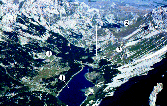
Cirque formed from giant doline (uvala) with rock basin (Skryke , Durmitor Mountains, photo by Veress). 1. Rock basin, 2. debris slope, 3. margin of partial doline covered with debris
Fig. 4.42 
Morphological map of a giant depression near Žabljak (sketch, not surveyed) (Veress 2016a, modified). 1. Side slope of paleodoline (giant solution doline), 2. infilled floor of paleodoline, 3. suffosion doline (diameter more than 1–2 m), 4. infilled suffosion doline, 5. suffosion doline (diameter less than 1–2 m), 6. suffosion doline with debris on floor (diameter less than 1–2 m), 7. dropout doline or opening in cover (diameter less than 1–2 m), 8. doline code, 9. ponor-like doline (covered karst ponor), 10. infilled covered karst ponor, 11. shallow solution doline on channel floor, 12. slope direction of gully and its floor, 13. ravine, 14. valley, 15. valley with incised meanders, 16. infilled ravine, 17. infilled valley, 18. buried gully, 19. buried ravine, 20. limestone outcrop, 21. limestone block (moraine), 22. artificial water inflow, 23. Watercourse, 24. lake, 25. bog in doline, 26. karst terrain bordering paleodoline, 27. road, a–c, covered karst ponor with creek (on the floor of types “a” and “b” there are subsidence dolines of different types), (d) suffusion doline with creek, (e) valley with a channel (gully) on its floor, there are a lot of small suffosion dolines on the valley floor, (f) coalesced suffosion doline which is separated into constituting dolines, (g) larger suffosion doline
-
According to the ground plan, they can be dolines (Figs. 4.36 and 4.37) and uvalas (Fig. 2.9). Several varieties of uvalas can be distinguished which can be the following:
-
Constituting dolines of the uvala constitute a grouped pattern. Former dolines could coalesce by karstification or glacial erosion.
-
Constituting dolines of the uvala create a row as a part of a trough.
-
The floor of uvalas is dissected by giant dolines . These latter could also coalesce by karstification or glacial erosion. Inner dolines are separated by thresholds or plain floor remnants from each other. Inner dolines can also be dissected by small-sized solution dolines and subsidence dolines .
-
-
As compared to the glacier valley, the dolines or uvalas can be valley dolines , valley floor dolines , cirque dolines , dolines transformed into cirques (cirque of karstic origin) and dolines outside the valley .
-
Valley dolines expand on the whole valley thus, the valley margin has an arcuate pattern. The doline and the slope of the valley do not separate from each other. The dolines are complex: larger dolines or uvalas have inner dolines or uvalas (Fig. 2.9).
-
Valley floor dolines deepen into the floor of the trough, by this, the remnants of valley floors could survive in different width at these features (Veress 2012a, Fig. 4.36). Valley floor dolines are of smaller diameter than valley dolines . As compared to the diameter of the latter, their depth is smaller too than in the case of valley dolines. Their slope is separated from the slope of the bearing valley (the slope of the doline is less steep than that of the valley). Valley floor dolines do not coalesce. The margin and side slope of the bearing valley are not arcuate.
-
The dolines of the cirques can be of various size. Both the dolines and the cirques which developed by the transformation of dolines can have straight or arcuate margins (Fig. 2.1). While the margin of the smaller is arcuate, there occur features with arcuate, straight and irregular margin among the larger. The margin of arcuate depressions with a larger diameter can be many times arcuate. Cirques could develop in the valley head of a river valley (see Chap. 2.4). They could develop by the transformation of a preglacial karstic depression (Fels 1929; Smart 1986) , where glacial erosion, snow erosion and mass movements might have had a role, while cirque dolines could develop with the karstification of the cirque (Barrére 1964; Djurovič et al. 2010). However, closed cirques can develop on glaciokarst too by glacial erosion only (Ford and Williams 2007). Cirques being developed from preglacial dolines (Fells 1929) are believed to be mixed features that continue their formation in the glacials and interglacials (Ford 1979).
-
-
Their floor can be exclusively bare karst , soil-covered karst and concealed karst . It may happen that uncovered and covered parts alternate in their area (Fig. 4.35). If there is a cover on their floor, the following karst types can occur in their area:
-
allogenic crypto karst and concealed karst with ponors and subsidence dolines ,
-
concealed karst and bare karst with subsidence dolines , karren , small-sized solution dolines and schachtdolines ,
-
bare karst and soil-covered karst with karren , small-sized solution dolines and schachtdolines ,
-
bare karst , soil-covered karst and concealed karst with karren , small-sized solution dolines , schachtdolines and subsidence dolines ,
-
allogenic karst, concealed karst and bare karst , in this case, all mentioned features occur in the depression.
-
-
Mixed, polygenetic features which were transformed genetically by glacial erosion (Ford 1979; Plan and Decker 2006; Annys et al. 2014).


The morphology of their shape can refer to the impact that affected them. According to their shape, their development can be the following:
-
The depression is a doline, according to this, it is of single-arcuate margin, there are giant dolines on its floor. In this case, a two-phase karstification took place which were probably interrupted by glacial erosion.
-
The depression is a doline, according to this, its margin is single-arcuate, in its inner part there are large-sized solution dolines and features of glacial erosion (roche moutonnée, rock basin) and/or moraine. In these features karstification and glacial effects were repeated several times.
-
The depression is an uvala, according to this, its margin is many times arcuate, karstic depressions, glacial features and a moraine occur in its inner part. This feature was formed with the coalescence of former dolines (during karstification , but mainly in case of those uvalas where constituting dolines constitute a row, in their coalescence the role of glacial erosion cannot be excluded either), then glacial erosion and karstification could be repeated several times.
The coveredness and feature assemblages is different in case of valley dolines , valley floor dolines and cirques.
-
Coveredness is more widespread in valley dolines and cirques. The cover partly originates from the frost weathering debris covering the slopes and partly from the ground moraine and terminal moraine covering the floor. On the contrary, in troughs where valley floor dolines exist, ground moraines have a smaller expansion and thickness.
-
In valley dolines (and in valleys) stepped surfaces are absent (or if they exist, they are buried). Thus, karren features are different and less widespread than in valley floor dolines and in the valleys bearing them. This can probably be traced back to the fact that karren formation could not take place or it took place only to a limited extent on the relatively steep slopes of giant dolines (which developed preceding ice formation) (grikes could not develop). However, it is also possible that glaciers had a weaker ability to remove bed units on the steep slopes (plucking is replaced by abrasion).
Exhuming depressions are called depressions of superficial deposit (DSD) by Veress (2009e, 2012a, 2016a) if their sediments were or are transported into the karst. Such an exhumed depression is mentioned from the Canadian Rocky Mountains by Ford (1979) . The depression with a diameter of 6 × 2 km became filled during Wisconsinan Glaciation . Since then the fill has been transported into the passages of the karst. Exhumation (the loss of the cover) can happen in the following ways:
-
During its dissolution, limestone debris gets into solution and is transported into the karst (Trudgill 1985) .
-
The cover is transported into the karst through ponors and subsidence dolines by mechanical erosion (rainwater, intermittent and permanent streams) (Veress 2009e; Bočič et al. 2012; Žebre et al. 2016).
According to the degree of exhumation, giant dolines (DSDs) can be the following (Veress 2016b):
-
A giant doline becomes exhumed to a small extent (Fig. 4.43) if there are few gullies and subsidence dolines without passages on its floor in addition to this, the passages of the bedrock are confined to the epikarst and thus, their sediment receiving capacity is small.
Fig. 4.43 
Depression of superficial deposit in the Grava Lunga cirque (Dolomites, photo by Veress) . 1. Doline zone of depression where material transport takes place into the karst, 2. depression, 3. ravine in morainic deposit
-
A giant doline becomes exhumed to a medium degree if the cavities of the karst are larger, for example there are shafts (Fig. 4.24a), the number of subsidence dolines is larger and at least some of them have passages.
-
A giant doline becomes exhumed to a great extent if on the floor there are subsidence dolines or ponors (with blind valley ) having gullies (Figs. 4.44 and 4.45). Mostly, if there is a well-developed cave system in the karst.
Fig. 4.44 
DSD of exhuming paleodepression (Hochschwab, photo by Veress ). 1. Ponor, 2. lake, 3. infilled ponor, 4. end of blind valley , 5. probable former level of fill, 6. valley, 7. gully, 8. allogenic karstic part of depression floor, 9. concealed karst part of depression floor, 10. margin of DSD (paleodoline)
Fig. 4.45 
Geomorphological map of the DSD of Hochschwab (Veress 2016a, modified). 1. Contour line, 2. spring (permanent and intermittent), 3. stream, 4. lake, 5. waterlogged area, 6. col, 7. exposed limestone, 8. cliff wall, 9. roche moutonnée or karstic residual feature, 10. edge of the DSD, 11. mound on the margin of the depression, 12. limestone ridge, 13. denuded side slope of the depression, 14. accumulational slide slope of depression, 15. allogenic karstic part of the depression floor, 16. concealed karstic part of the depression floor, 17. nivation and mass movement features of the side slope, 18. slide, 19. thufur field, 20. infilled ponor, 21. active ponor, 22. recent uvala, 23. small-sized solution doline , 24. shaft, 25. rain furrow, 26. gully, 27. channel on valley floor, 28. valley, 29. tourist track


Djurovič et al. (2010) typified large-sized depressions considering karstic and non-karstic processes taking place inside them. The following depression types were distinguished:
-
Depressions of glacial uvala type have the most elevated position. Inside them, cryogenic-nivation processes operate. A karstic process is manifested in global (areal) dissolution. A lot of debris is generated, karst features are represented by karren , the density of which is small.
-
Depressions of glacial-karst uvala type are of lower elevation (or temperature is higher inside them). In their area, intermittent streams occur which are fed by snow patches. Their length is short and they are drained into the karst. Intermittent lakes can also be formed in their karst features. Karstification prevails in their area: ponors , sinkoles (subsidence dolines ?), karren occur on their floor.
-
Depressions of glaciofluvial uvala type are of the lowest elevation. Their streams which can also be permanent create blind valleys. Karstic processes are determinant, sinkholes, ponors , permanent lakes may occur in their area.
It is indisputable that in giant depressions of higher elevation where vegetation is absent, snow erosion and frost weathering are powerful. The intensity of the above-mentioned processes decreases in giant depressions of lower elevation. (In the latter, with the growingly larger expansion of soil and vegetation, dissolution which can be traced back to biogenic CO2 is increasingly significant and the role of snow erosion and frost weathering decreases increasingly in their formation.) However, the type of the developing features (ponor or subsidence doline) is not elevation dependent (and thus, the degree of the transportation of the cover into the karst either), but it depends on the expansion, thickness, grain size and composition of the superficial deposit. However, frost weathering has an effect to the degree of inward sediment transport in the depressions: continuously less material of such origin arrives at depressions of increasingly lower elevation.
Depending on the fact whether inward sediment transport is smaller or larger than sediment transport from the depression into the karst, giant depressions can be exhuming (Figs. 4.43, 4.44 and 4.45) or infilling (Fig. 4.46) and infilled (Fig. 4.47). These processes do not only happen at present, but they also took place during the Pleistocene. Cave fills (Bočič et al. 2012; Kiernan et al. 2001) refer to the fact that accumulation and exhumation alternated and were repeated in various depressions. On karst, the degree of exhumation depends on the degree and intensity of cover denudation and on the possibility of sediment transport into the karst (on the floor, it depends on the number of ponors and subsidence dolines and on their sediment transport capacity), on the sediment receiving capacity of the karst (on the density, size, morphology and pattern of cavities).

Aerial photograph taken under Wildgössl (cirque formed from giant doline, Totes Gebirge, photo by Veress). 1. Side of giant solution doline with debris fans, 2. floor of giant solution doline with superficial deposit, 3. slope of giant solution doline eroded glacially, 4. covered karst ponor, 5. gully, 6. covered karst terrain intruding into the glacially eroded surface, 7. a subsidence doline in the zone of thin superficial deposit next to rock boundary , 8. zone of springs

Infilled, smaller sized (truncated?) giant doline (northern foreground of Durmitor, photo by Veress )
On glaciokarst, sediment transport and thus, its arrival at the cavities of the karst is promoted by the increase of the amount of meltwater that happens to the effect of warming at the end of the glacial . (However, stream load can also be significant in the interglacial too because of the increased amount of precipitation.)
According to Woodward et al. (2008), the amount of water flowing down the surface (and thus, the degree of sediment transport) is also different in the glacials and interglacials since ice and the developed moraine-blocked percolation in the glacial . However, as the percolation of meltwater also takes place below the ice, only a part of this could leave the glacier. However, the amount of escaping meltwater might have depended on several factors too: thus, on the maturity of the epikarst and on the inclination of the bearing terrain.
However, the increased amount of sediment can contribute to the plugging of ponors , partly in a way that caves become upfilled and infilled and partly in a way that the entrance of ponors becomes plugged. While preceding the plugging of the ponor, the exhumation of karstic depressions is characteristic, following plugging, accumulation is specific. The increased amount of water can contribute to the rise of the karst water level which further increases the upfilling of the caves (Bočič et al. 2012). At the same time, the decline of the karst water level contributes to the further transportation of cave sediment . Fine-grained sediment contributes to the plugging of drainage passages (if they are underdeveloped), while coarser-grained sediment contributes to the upfilling of the caves (if sediment gets into the cave).
Surface accumulation is caused by the advance of glaciers at the start of cold phases when the amount of meltwater decreases. In the glacials, accumulation spreads to caves too (Kiernan et al. 2001) . However, floods also cause accumulation, the water of which originates from the lakes plugged by moraine if karstic water drainage ceases from the lakes (Stepišnik et al. 2010). Further, transportation and reworking of the sediment is slowed down both on the surface and in the caves (thus, on the surface, exhumation, the clearing of caves and thus, the reception of newer sediment is slowed down) by the cementation of the sediment which takes place in the interglacials (Hughes et al. 2006; Adamson et al. 2014; Žebre and Stepišnik 2015a), by vertical water drainage under the glaciers (Žebre and Stepišnik 2015a) and by ground ice. Ground ice may have a lower position in the glacials and a higher position in the interglacials.
4.5.1.1.2 Small-Sized Solution Dolines and Schachtdolines
Small-sized solution dolines (Fig. 4.48) have steep sides. As it has already been mentioned, their width or depth is mostly some metres, those with a diameter larger than 10 m rarely occur. Because of their specific shape, these features are also called trichterdolines (Fink 1973; Plan 2005) .

Small-sized solution dolines (Maglič Mountains, Montenegro, photo by Veress )
These features can occur in giant dolines , in troughs, in cirques or on surfaces and plateaus with slopes being scoured by glacial erosion. According to Bauer (1962), small-sized solution dolines are of postglacial age, which is also proved by the fact that they often occur in giant dolines (uvalas ). Their small size can be explained by their young age. Their characteristic features are the following:
-
Their density is small, they mainly occur individually, their occurrence in groups is rare.
-
They are vertically well developed: their depth is hardly smaller than their upper (marginal) diameter, their floor diameter is very small, and so they are funnel-like.
-
Their side slopes are steep.
-
Rarely, but it can be observed that despite their small size, they can form uvalas . It is probable that they do not coalesce by their horizontal growth, but they already coalesce during their development. They can also be complex. In this case, the floor of the long shaped, but narrow depression is dissected into constituting dolines (Fig. 4.49).
Fig. 4.49 
Complex feature: small-sized solution dolines in a larger depression (Hochschwab, photo by Veress )
-
The dolines deepen into the karstic rock. Therefore, can be differentiated from subsidence dolines . On their side of slopes, there is limestone in smaller or larger patches (In this case, it crops out from below the soil), on their floor there is soil and rock debris.
-
If they occur on a steep slope, they are elongated in slope direction and have an asymmetric cross section. Their slope falling in the dip direction of the bearing slope is smaller and steeper, while the opposite is more gentle and longer.
-
They occur above the tree line (mainly in the lower, dissolutional subzone of the periglacial zone ). The shape of dolines below the tree line, although their sizes are smaller than those of giant depressions , is characterized by gentle slopes and a large diameter as compared to depth (Fig. 4.50) thus, the latter are temperate dolines (Ford and Williams 2007).
Fig. 4.50 
Temperate solution doline with subsoil karren on its floor (Asiago plateau, Italy, photo by Veress )


Schachtdolines are dissolutional features with vertical or almost vertical sides and a plain floor (Figs. 4.51 and 4.52), with frost weathering debris and with snow often surviving during summer months on their floor. Above the tree line , they are mostly characteristic of the upper part of the periglacial zone (in the subzone of mass movement and frost weathering). They are also of small size: according to Kunaver (1983), on the Kanin plateau, their average diameter is 7.1 m (the largest diameter does not exceed 20 m), while their average depth is 5.9 m. A significant characteristic of the steep side slope is that it is bare and exempt from vegetation. (In contrast with this, the side slope of small-sized dolines is not bare or it is partly bare.) The lack of vegetation can not only be explained by low temperature resulting from high altitude (since Pinus mugo can occur in their environment too), but also by the fact that the snow fill of long duration impedes the formation and development of vegetation on their slope. Their diameter exceeds their depth to a less degree than in case of small-sized solution dolines . They can occur in groups too. In this case, they can even be uvala-like. The dividing walls between them can get holed by corrosional, frost weathering processes (arches may develop) or they can collapse. Their density is changing, it can be large too. Bauer (1962) mentions 900 schachtdolines from an area of 1 km2 from the Alps . They have a varied morphological environment: they occur on lower combe-ridges, on small-inclined slopes of glacier valleys, but they are less specific in giant dolines. According to Kunaver (1983) , they can be found over 1600 m on the Kanin plateau.

Schachtdolines with twin-like development (Totes Gebirge, photo by Veress)

Schachtdolines from Kanin Mountains (Kunaver 1983, modified). 1. Bedding plane, 2. fracture, 3. snow
Schachtdolines often have a mixed occurrence: small-sized solution dolines or if superficial deposit is present, subsidence dolines may occur in their environment (Fig. 4.53). According to Kunaver (1983), about half of the schachtdolines of Kanin are elongated in the direction of those fractures along which they developed. However, they can also be elongated in the dip direction of the bearing slope or in the dip direction of the beds. Schachtdolines being elongated in slope direction or in the dip direction of the bed are asymmetric. Their side slopes dipping opposite slope direction and opposite dip direction of the bed is steeper and shorter. Their floor does not always terminate blindly in the bedrock, but they continue in a grike or passage (Fig. 4.52). Ford (1984) describes cenote-like schachtdolines from the Canadian Rocky Mountains too. Intermittent lakes were formed in these features when an ice plug developed below them in the drainage passage.

Schachtdolines (1), small-sized solution doline (2), subsidence doline (3) (Maglič-Mountains, photo by Veress)
According to Kunaver (1961, 1983) and Ford (1979), schachtdolines are postglacial features. However, according to Kunaver (1983, 2009a), fossil schachtdolines having been truncated by glacial erosion may occur too, which can refer to the fact that the conditions of their formation were also present in the interglacial (s). They develop during the local dissolution of the meltwater of snow accumulations (Kunaver 1983; Ford 1979) . According to Stepišnik et al. (2010), they are formed by the meltwater of glaciers.
The cause of the small diameter of both the small-sized solution dolines and the schachtdolines is that they do not increase laterally which can be explained by the lack of horizontal dissolution. The fine-grained cover intensifies horizontal water movement. The coarser-grained the cover, the more vertical the water movement (Veress 2016a). Since there is no fine-grained sediment on the floor of these features, there is at most soil (it is probable that soil appeared in the late phase of their development when there were favourable climatic conditions inside them), snow water gets rapidly into the karst without lateral percolation, promoting downward dissolution. Vertical maturity and snow accumulation strengthen each other: the deeper the doline, the more snow accumulation can take place in it, however percolating snow water maintains further deepening. These features can develop in the periglacial zone because the survival of snow is favoured by high altitude and snow accumulation (snow drifts) is favoured by the lack of trees. However, the permanent survival of snow cannot be only favoured by higher altitude, but by local circumstances (wind conditions, exposure, the morphology of the environment) too. Therefore, the pattern of their distribution can be varied and influenced by local conditions.
It is probable that a schachtdoline develops if complete snow fill survives for a long time even in summer in the deepening depressions. By this, the doline deepens in its whole expansion below the snow and thus, a plain-floored feature develops with steep sides. A small-sized solution doline develops if the snow fill in the depression decreases for a long duration in summer. By this, the expansion of snow will be smaller thus, dissolution is focused to a smaller area on the doline floor, causing the formation of a tunnel-like shape with narrowing, gentle slopes.
4.5.1.1.3 The Comparison of Giant Dolines with Small-Sized Solution Dolines and Schachtdolines
If we compare the solution giant dolines , the small-sized solution dolines and the schachtdolines of glaciokarst, then they show differences in the following characteristics:
-
Giant dolines (and uvalas ) are of great size, (their width can exceed 50–100 m and their depth can exceed several 10 m), while the size of small solution dolines and schachtdolines is small (their depth and width are some metres).
-
The shape of giant dolines is large, while that of small-sized solution dolines (but of schachtdolines too) is small.
-
As it has already been mentioned, the inclination of the side slopes of giant dolines is small, while the dip of small-sized solution dolines and schachtdolines is large.
Consequently, giant depressions are horizontally developed, while small-sized solution dolines and schachtdolines are vertically developed. Although glacial erosion contributed to the horizontal maturity of giant depressions, they could mainly achieve this characteristic by horizontal dissolution. Regarding their characteristic features, they are similar to the dolines of the temperate belt, which are characterized by large diameter as compared to the depth and also by gentle side slopes (Ford and Williams 2007). Therefore, giant depressions (dolines, uvalas ) did not develop in a glaciokarstic environment, but in another one which favoured their horizontal growth of karstic origin (lack or smaller amount of snowmelt, soil or fine-grained cover on the floor). On glaciokarst, such circumstances can be expected in case of a climate warmer than the present one, which could exist when the glaciokarst was of a lower elevation than today. Thus, they can be regarded as paleokarstic features.
Their shape was further modified by glacial erosion. Thus, the inclination of their side slopes and their depth could decrease during glacial erosion and accumulation. However, their further growth and transformation were also contributed by periglacial processes and snow erosion (Žebre and Stepišnik 2015b).
The differences in the shape and the size of giant solution dolines as compared to small-sized solution dolines and schachtdolines can be explained by their different development age. The preglacial or interglacial development of giant dolines is proved by the following things:
-
There may be a moraine on their floor (Kunaver 1983) .
-
Valley floor dolines often with a diameter of several hundred metres could not reach their large size during postglacial dissolution of short duration.
-
Inside them, there may be small-sized solution dolines with steep sides and of postglacial age, subsidence dolines that developed in moraine and roche moutonnées referring to glacial erosion (Fig. 4.37) and hogbacks.
-
In these karstic depressions and in caves situated below them, fluvioglacial sediments may occur (Bočič et al. 2012), which indicates that they had a sediment receiving capacity in the last glacial .
-
The direction of the elongatedness of karstic depressions is identical with the direction of the movement of the ice sheet on the Burren glaciokarst in Ireland (Drew 2004) . The concordance of the orientation of depressions with the direction of ice movement refers to glacial erosion which proves that they had already existed in the last glacial.
-
They can form cirques and troughs (Figs. 2.1, 2.9, 4.40 and 4.41).
According to their development age, valley giant dolines and uvalas can be put into two groups:
-
Those constituting troughs or cirques and there are further karstic features inside them, mixed features and thus, they underwent several karstifications and glaciations. Thus, they are probably of preglacial age or they developed in any of the older interglacials.
-
Those which are not complex and they were formed on the floor of glacier valleys, they were probably developed in the last interglacial .
4.5.1.2 Subsidence Dolines
4.5.1.2.1 Their Varieties and Characteristic Features on Glaciokarst
Subsidence dolines develop on covered (concealed) karst. These dolines are formed either in their complete expansion or predominantly in the cover of karst (Fig. 4.34). Their varieties are dropout dolines , suffosion dolines and compaction depressions (Waltham and Fookes 2003; Williams 2004; Waltham et al. 2005) Dropout dolines develop on cohesive (on clay, clayey sediment ) rock (Waltham and Fookes 2003) by collapse. According to this, their side slopes are steep (nearly vertical) surfaces. According to Waltham et al. (2005), they develop by the collapse of the cavity that was formed in the cover. However, dolines of collapse origin can also develop on less cohesive rock if collapse already occurs on the bedrock which is inherited to the cover (Veress 2016a). They can also be formed if there is a well-soluble rock under the non-cohesive cover. Ford (1979) describes such dropout dolines from the Canadian Rocky Mountains which were formed by the collapse of the moraine, since the gypsum cavities of the bedrock collapsed. The development of suffosion dolines mainly takes place by suffosion: since the non-cohesive grains of the cover are accumulated in the passages of the bedrock by meteoric water percolating through the cover. Thus, the side slope that was formed in the loose superficial deposit is not vertical though it can be of extremely diverse steepness. A compaction depression (compaction doline) develops by the compaction of the grains of the cover which is the fill of an older, filled doline. Its side slopes are of very small inclination. Compaction dolines should not be necessarily differentiated from suffosion dolines: on the one hand, compaction takes place in the cover in the case of suffusion dolines too, on the other hand, the process is preceded by material transport from the cover here too, and third not only these dolines can develop in the fill of older karstic depressions.
Ground water or karst water are important factors in the development of subsidence dolines (Xu and Zhao 1988). Because of the decrease of the water level in the cover, the support of the cover decreases (this favours the development of dropout dolines ) and the possibility for rainwater percolating through the cover increases, which promotes the chance for suffosion doline formation. The fall of the water level can be both of natural and artificial origin (Beck and Sinclair 1986; Waltham and Smart 1988) . On glaciokarst, the formation of subsidence dolines related to ground water level decrease can take place during the retreat of glaciers. In this case, a lot of meltwater is generated which creates groundwater in the cover. However, later during vertical water drainage, the water level of groundwater that developed in this way decreases.
On glaciokarst, surfaces of superficial deposit with smaller or larger expansion (thus, covered karst ) are widespread, where subsidence dolines can develop. Covered karst and thus, subsidence dolines can be present in the periglacial zone , but in the fluvial erosional zone of the temperate belt too. Subsidence dolines can occur everywhere where superficial deposit exists: thus, in cirques (Fig. 4.24a), on the floor of troughs (Fig. 4.24b) and in giant depressions . They can also occur in giant depressions which are outside a glacier valley (Figs. 4.54 and 4.55) and in those which are situated on the floor of troughs (Fig. 4.56). Subsidence dolines can be found on alluvial cones (Fig. 4.38) at the margin of the debris mounds of mountain failures (Figs. 4.57 and 4.58a), in the gaps of hummocky moraines (Fig. 4.59) in gullies and creeks (Fig. 4.42). However, according to Ford and Williams (2007), subsidence dolines can develop on limestone pavements covered with frost weathering debris. However, it can be experienced that the frequency of suffosion dolines is larger in giant dolines and cirques, while dropout dolines are more characteristic on the floor of troughs exempt from giant dolines. The size and morphology of the suffosion dolines of various giant dolines show considerable similarity.

Giant doline with suffosion dolines on its floor that constitute an arcuate row (Rax , Austria, photo by Veress)

Subsidence dolines (1) developed in a giant doline (2) (under Triglav , Julian Alps, photo by Veress )

Suffosion dolines (a, b) of giant dolines on the trough floor (Totes Gebirge, photo by Veress)

Suffosion dolines that developed on the blocks of mountain failure in a giant doline (near Lake Vd. Lahngang, Totes Gebirge, photo by Veress)

Karstification of paleodolines partially covered on the material of mountain failures (a), on debris fans of rock avalanches (b) and on debris slopes (c) (Veress 2016a, modified). 1. Siliceous layer, 2. collapsed blocks, 3. frost-shattered debris with limestone, 4. frost-shattered debris partly of limestone, partly of siliceous material, 5. reworked debris, 6. morainic deposit, 7. watercourse, 8. ravine, valley, 9. paleodoline, 10. ponor, 11. subsidence doline, 12. outer part of cover, where the cover is thin, and therefore karstification takes place in the doline, 13. heap of mountain failure, zone of debris fans, buried section of paleodoline (no karstification) 14. side of glacial valley with mountain failure, 15. plateau, aréte, 16. slope of glacial trough dissected with cliff niches and rock avalanches, 17. debris reworked by watercourses (alluvial fan), 18. slope of glacial trough with siliceous intercalations

Karstification of terrains enclosed by morainic hills (cirque of a glacial valley in the Hochschwab, photo by Veress ). 1. Morainic hill, 2. covered karst terrain enclosed by morainic hills, 3. subsidence doline
The cover, in which subsidence dolines develop on glaciokarst, can be moraine, glaciofluvial sediment , materials of mountain failure, frost weathering , and rock avalanches or purely fluvial sediment. On the British Islands , suffosion dolines that developed on terrains with moraines are termed shake-holes (Sweeting 1973) . According to Sweeting (1973), the side slopes of these features are unstable, dissected by slides and their shape changes. They are elongated in slope direction and have an asymmetric cross section. According to Sweeting (1973), their size depends on the width of joints, on the thickness of the till, on the intensity of water drainage into the karst and on the inclination of the surrounding surface. According to Sweeting (1973) , their average depth is 3 m and their diameter is 8–11 m.
On glaciokarst, subsidence dolines have specific characteristic features. These are the following (Veress 2016b, 2017b) :
-
Although subsidence dolines also have a smaller size on karst of other types than the dolines of other doline types (for example solution dolines or collapse dolines ), except the subsidence dolines of evaporite covered karst , on glaciokarst, the small size is predominant (Sweeting 1973; Waltham et al. 2005 , Figs. 4.59, 4.60 and 4.61). Their width and depth are some metres, but their depth does not often reach 1 m either. Thus, in the area of Mlječni do (Durmitor ) 5 out of 9 suffosion dolines have a depth smaller than 1 m, but neither of them exceeds a depth of 2 m. As another example can be mentioned the suffosion dolines being formed on the alluvial cone of a giant uvala in Dachstein (Figs. 4.38 and 4.39). Here, only 14 out of 64 suffosion dolines have a diameter larger than 2 m (but neither of them have a diameter exceeding 5 m). Although small-sized dolines (with a diameter of 1–2 m) occur on other covered karsts too, there may be dolines with a larger diameter and depth in a significant proportion too. Thus, on Pádis karst (Romania ) in addition to the above-mentioned smaller ones, there occur dolines the size of which exceeds 60 m along their longitudinal axis, but subsidence dolines with a diameter of 30–50 m and with a depth of 5–8 m often occur here too. The possible causes of small size are the following (Veress 2016a):
-
Their development could only start after the retreat of the ice. This can be some thousand years in the periglacial zone . The dolines of non-glaciokarst can also be of young development age, but the possible development age (potential development age) is not limited by the disappearance of ice cover. Therefore, while the age can be diverse in case of the former, the age of the latter is always young.
-
In the bedrock, cavity size is small since because of glacial erosion, the epikarst zone under the actual surface is young. (The large caves of the karst are situated far from the majority of subsidence dolines in a large depth.) There are few and small cavities which are only able to receive a small amount of cover, the cavities become filled and plugged fast and easily. Because of this, even if a cavity with a more significant size exists deeper, the cover is not able to be transported there.
-
The cover is mostly coarse-grained. Because of this, suffosional material transport is limited. Coarser material (rock debris) is accumulated even in the initial section of the cavities. This filters the later inward transported sediment , the fine-grained material gets stuck on the debris. Thus, the sediment is not able to be transported deeper.
-
The cover is often thin. Therefore, only suffosion dolines with a small depth can be formed in it. However, dropout dolines have a small depth not only because of the above-mentioned cause, but also because as a matter of course only small-sized cavities can develop in the cover with a small thickness.
-
The material of the cover is mainly limestone. Because of this, if the cover is extremely thick, the meteoric water percolating through it arrives at the bedrock saturated. Under such a cover there is no cavity development in the bedrock at present. By this, on the bedrock, there are only cavities that had been inherited earlier (from the period preceding covering).
-
In case of a thinner cover with limestone debris, the bedrock can be dissolved, but only to a small degree. During percolation through the cover, the water becomes partly saturated thus, its solution capacity is small on the bedrock and thus, dissolution is of a small degree too.
-
In areas bearing subsidence dolines , following the retreat of ice, ground ice is present in one part of the year. Because of this, water percolation and material transport through the cover was and is only possible only during a short period of the year.
-
Because of their large density, their catchment area is small or does not exist at all thus, they get a small amount of water and suffosion is of a small degree too.
Fig. 4.60 
Typical small-sized suffosion dolines (Tauplitz alm , Totes Gebirge, photo by Veress)
Fig. 4.61 
Suffosion (a) dolines (Dolomites) and dropout (b) dolines (Durmitor) that developed in large densities (photo by Veress)
-
-
The distribution of dolines is diverse. There occur terrains exempt from dolines, but there are such small-expanding doline patches where their density is extremely high. Thus, on the already mentioned alluvial cone of Dachstein giant depression, the density is 0.031 doline/m2. Although larger subsidence doline densities also occur on covered karst of mountain of medium-height (thus, on the floor of a karstic depression of the already mentioned Pádis, the density can be 0.021 doline/m2 too), small doline density is more characteristic on non-glaciokarst. Thus, in the Bakony Mountains (Hungary) subsidence doline density is 15 doline/km2 (Veress 1982). The density can be so high on glaciokarst that small mounds (with a circular or elongated ground plan) remain from the former flat terrain between the dolines (Fig. 4.62). The cause of the large density, which is mainly characteristic of the subsidence dolines of giant depressions , is that the meteoric water having fallen to the area of giant depressions can get into the karst only at this place. In addition to this, snow accumulates in the depressions from their environment thus, the size of snow packs exceeds the area or the catchment area of giant dolines. (Snow blown by the wind can originate from outside the catchment area.) Therefore, a relatively large amount of water can get into the giant depressions and into their superficial deposit which promotes the chance for the development of subsidence dolines on their floor. Great doline density may be not only specific of giant depressions. Therefore, it is probable that the large density can be traced back to the large density of karren features (which can also occur outside giant dolines) too since these latter may also be capable of receiving sediment (Fig. 4.63). Clayton (1966) described this way of development. The density of subsidence dolines is extremely high if there is halite under the moraine (Ford and Williams 2007). It can also be observed that the frequency of suffosion dolines is larger than that of dropout dolines . This can probably be explained by the grain size of the cover. Dropout dolines are formed on fine-grained, clayey cover, the occurrence of which is less frequent on glaciokarst than that of coarse-grained cover.
Fig. 4.62 
Mounds survived from the original terrain because of large doline density (Totes Gebirge, photo by Veress)
Fig. 4.63 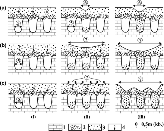
Suffosion dolines formed on cover above grikes (Veress 2016a, modified). 1. Limestone, 2. coarser grained cover, 3. finer grained cover, 4. water infiltration and debris redeposition, 5. grike, 6. small doline with a diameter smaller than 1–2 m, 7. larger doline with some metres’ diameter, a small-scale doline above grike, b larger doline formed above several grikes, c development of larger doline with different rates of redeposition of debris into the grike, the floor of which will be uneven, i initial stage, ii–iii doline formation
-
Their development is young, they were formed after the retreat of glaciers, following the development of the moraine. Therefore, the higher their elevation, the younger they are. It is probable that if they are absent on terrains of higher elevation it cannot always be traced back to the lack of development conditions, but it can also be explained by the fact that the short duration of deglaciation has not made their formation possible.
-
Their formation is rapid. Thus, in the cirque under Triglav there was ice 50 years ago (Gams 2002) . As they could only be formed following deglaciation, those occurring here are younger than 50 years old.


As regards their development age and rate of development, they show similarities with the formation and development of subsidence dolines that were formed in extreme development environment, but are not of glaciokarstic origin. Thus, in the valley of the river Flint (USA) 312 dolines were formed within 48 h in 1994 during a tropical storm (Hyatt and Jacobs 1996) . A gypsum bedrock or water extraction also results in a rapid development on non-glaciokarst. Thus, above a gypsum bedrock in the valley of Elbro River (Spain) a subsidence rate of 64.5 mm/year was also measured on a doline floor (Soriano and Simon 2001), while following a water extraction of 8 years 1032 dolines developed near the town of Liupunshui (China) (Waltham and Smart 1988). However, a rapid formation can be experienced under less extreme circumstances too. On loess, on the covered karst of Montgomery County (Tennessee state) , the age of dolines was estimated to be 65 years (Kemmerly and Towe 1978).
4.5.1.2.2 Their Morphology
The characteristics of their morphology are the following:
-
Among the subsidence dolines of glaciokarst, the varieties of dropout dolines can be well-distinguished morphologically which are the following (Veress 2016a). Dropout doline with soil developed in soil (Fig. 4.64a). This variety represents the initial phase of doline development. It also occurs on other covered karst . The floor of the dropout doline with a plain floor is flat and wide as compared to its depth. While its depth is of some tens of centimetres, its diameter can be several metres. The margins of the dolines of this doline variety are straight and in this case, the neighbouring margins enclose an angle with each other or they are separated into smaller, arcuate sections. They are the specific dropout doline variety of glaciokarst (Figs. 4.61b and 4.64b). The floor of the dropout doline with boulders is covered by boulders (Fig. 4.64c). The depth of dropout dolines with boulders is relatively large (0.5–1 m) as compared to their diameter (1–2 m). Although the side slopes of asymmetric dropout dolines are not vertical, their slopes intersect the soil and the cover too. The downstream side slope is shorter than the upstream (Fig. 4.64d). It is not a common doline variety, it only occurs on glaciokarst. The suffosion dolines of glaciokarst are less likely to constitute morphological varieties. However, suffosional blind-ended gully can be mentioned (Veress 2016a), which is a closed, channel-like feature (Fig. 4.38). It is a non-widespread, rare doline variety.
Fig. 4.64 
Dropout doline varieties: a dropout doline with soil (Durmitor ), b dropout doline with plain floor (Durmitor), c dropout doline with boulders (Durmitor), d asymmetric dropout doline (Hochschwab, photo by Veress )
-
Subsidence dolines can occur individually or in groups. On glaciokarst, when they occur in groups, they can form a straight row (Fig. 4.65), an arcuate row (Fig. 4.54) and an irregular group (Figs. 4.55 and 4.61). Subsidence dolines outside giant dolines are grouped in a straight row, while those situated in dolines can constitute a straight row (Fig. 4.35), an arcuate row (Fig. 4.54), or an irregular group (Fig. 4.61a).
Fig. 4.65 
Subsidence dolines formed on till along fracture (crack) (Durmitor, photo by Veress ). 1. Active subsidence doline, 2. inactive subsidence doline, 3. rills produced by runoff from rainfall or snowmelt, 4. Sušica canyon
-
Subsidence dolines have passages which can be in the cover (passage in fill or non-karstic pipe) and in the bedrock too, or exclusively in the karstic rock if there is no cover on the floor. A floor without a cover is not characteristic of the dolines of glaciokarst and thus, the passages can be formed in the cover too (Fig. 4.66).
Fig. 4.66 
Passage with a diameter of some cm (Tauplitz alm , Totes Gebirge, photo by Veress). 1. Embryonic suffosion doline, 2. passage in fill
-
Subsidence dolines can be simple and complex (Figs. 4.67 and 4.68). In the latter, in addition to passages, inner dolines, scars of mass movements, erosional features (gullies, creeks), debris cones and alluvial cones may occur. The subsidence dolines of glaciokarst belong to the simple variety. However, according to Ford (1984), on the floor of the subsidence dolines of glaciokarst there may be inner depressions of collapse origin too. According to him, these inner depressions are of postglacial age, but the bearing features are older than the last glaciation. On the side slopes of the subsidence dolines of glaciokarst, at most smaller scars of mass movements can occur. These are soil creeps , gelisolifluctional mass movements and rarely soil falls .
Fig. 4.67 
Elements of a simple suffosion doline (Veress 2016a, modified). 1. Limestone, 2. superficial deposit, 3. collapsed material, 4. interior subsidence doline, 5. passage, 6. shaft
Fig. 4.68 
Elements and morphology of a composite suffosion doline (Veress 2016a, modified). 1. Limestone, 2. superficial deposit, 3. bearing surface, 4. doline fill, 5. ravine, 6. gully, 7. slide, 8. slide heap, 9. alluvial fan, 10. flat floor, 11.a. interior suffosion doline, 11.b. interior dropout doline, 12. subsidence doline in marginal position, 13. passage in fill, 14. chimney, shaft, 15. upper part of doline without fill: with the erosion of slopes the doline was broadening and its slopes were getting gentler, 16. infilled lower part of the doline, 17. infilled non-karstic pipes in the doline
-
The floor of subsidence dolines is often flat because of their filling up. This morphological characteristic is not specific to the dolines of glaciokarst. A plain floor occurs in case of dropout dolines because of their development by collapse. The floor of suffosion dolines is usually not plain, but funnel-shaped. This is caused by continuous material transport from the doline into the karst.
-
Rain furrows, gullies, and creeks are often connected to dolines . On glaciokarst, the dolines of glaciokarst are less likely characterized by these features. Rain furrows occur more often (Fig. 4.65), while gullies (Fig. 4.69) are rarer. The smaller frequency of gullies and creeks can be caused by the lawn, the longer duration of frozenness of the soil, the smaller frequency of more intensive rainfalls and by the fact that surface runoffs are short because the dolines are situated close to each other.
Fig. 4.69 
Gully (marked b) of one of the subsidence dolines of the giant depression that can be seen in Fig. 4.42 (Durmitor, photo by Veress )
-
Subsidence dolines can be circular, elongated or grike-like (in this latter case, the opposite margins are parallel). Subsidence dolines with an elongated ground plan are formed along fractures or on slopes with a larger inclination. On glaciokarst, elongated suffosion dolines can develop along fractures (Fig. 4.65), but they can be elongated in the direction being identical with the dip direction of the slope too. Although suffosion dolines that developed on surfaces with slopes are not always elongated (their diameter may be larger in the strike direction of the slope), they can be asymmetric (Fig. 4.70). In this case, the side dipping oppositely the inclination of the slope is steeper and shorter. The dropout dolines of glaciokarst do not often have an arcuate ground plan, but they have a square, rectangle one.
Fig. 4.70 
Asymmetric doline (Totes Gebirge, photo by Veress)
-
Subsidence dolines are mostly formed in fine-grained sediment and rarely develop in coarse-grained sediment. A reversed situation is specific of glaciokarst: they are more often formed in coarse-grained cover (Figs. 4.56b and 4.61a).
-
The catchment area of subsidence dolines is small and usually it is not an individual catchment area which could be well separated from other dolines. On glaciokarst, this is true to a larger extent and the dolines often lack a catchment area completely, they only receive water from the meteoric water falling in their area.
-
The side slopes of subsidence dolines can be convex, concave, straight and normal slopes (they consist of convex and concave parts). The side slopes of the dolines of glaciokarst are mainly short and straight.
-
The diameter of the suffosion dolines of glaciokarst is smaller as compared to their depth than that of dropout dolines . These latter have a small depth and their diameter is large compared to this.
-
Intermittent or permanent lakes often develop in subsidence dolines . In the lack of detailed investigations, it cannot be estimated either whether lakes are formed more rarely or more often in the dolines of glaciokarst as compared to other covered karsts. At the same time, one of the inducing factors of lake development is only specific of the subsidence dolines of glaciokarst: in a permafrost environment, an ice plug can develop in the drainage passages which results in the back swelling of water in the passage (Ford 1984).


4.5.1.2.3 Their Evolution
The development age of subsidence dolines may be identical with the age of the sediment receiving feature being formed on the bedrock or it can be younger than this. In the former case, the doline development is syngenetic, while in the latter it is postgenetic (Veress 2016a). On glaciokarst, where the superficial deposit is mainly of limestone material, the water percolating through this can become saturated. Syngenetic, subsidence dolines can develop in case of limestone cover if the percolating water still has a dissolution capacity on the bedrock and therefore, it is able to create sediment receiving passages there. However, if it does not have a dissolution capacity, subsidence dolines can only develop, which are thus, postgenetic if sediment-receiving features had already been formed on the bedrock. In case of a postgenetic development, the sediment receiving features of the bedrock could be formed by meltwater (under the ice or in the foreground of the ice), but they could also develop preceding ice formation.
If the water arrives at the bedrock in a saturated state because of large cover thickness, the already existing drainage passages do not increase, karstic passages may become filled and there is a large chance for the cessation of doline development later. (Moreover, as the grain size of the cover increases, it is increasingly difficult to be transported by suffosion and the sediment receiving passages of the bedrock should be increasingly wide to be able to receive the grains.) If the water arriving at the bedrock still has a solution capacity, the doline development still takes place because of the increase of the drainage passage. A chance of the subsequent increase of the bedrock passages increases even if surface water arrives at the karstic passages through the drainage passage of the postgenetically developed doline. Since it does not percolate through the cover, this water does not become saturated, because of this getting into the passages of the bedrock, it widens them by dissolution. The non-percolating away surface water not only becomes saturated, but it can also transport CO2 surplus. This is proved by the fact that a relation can be determined between the cave flood wave (which takes place because of the streams flowing inward through ponors ) and the increase of the CO2 content of cave air in the Hungarian Baradla cave and Béke cave (Stieber and Leél-Őssy 2016) .
Suffosion dolines can be formed above the karren features of the bedrock (Clayton 1966), above its shafts and giant grikes (Ford and Williams 2007). However, the larger the features that developed on the bedrock, the larger the chance that instead of suffosion (or together with it), gravitational rock fall and the subsidence of the cover play a role in the development of dolines. Suffosion dolines can develop in the following ways (Veress 2016a).
-
The cover is transported into the karren mainly by suffosion. In this case, small-sized suffosion dolines develop either in a syngenetic or postgenetic way too (Fig. 4.63). Dolines developing in this way have a small size and a large density.
-
The superficial deposit gets into the shafts by the fall of debris parts, perhaps by subsidence or collapse. The dolines are postgenetic and relatively large sized. The material of the cover can get into the shafts directly or indirectly. In case of a direct development, the debris parts of the cover fall into the shaft that has no sediment fill (Figs. 4.24a and 4.55). An indirect development takes place if the upper part of the shaft is filled. In this case, during depression formation, the material of the cover can get into the shaft in several ways. Thus, the finer grained superficial deposit is accumulated in the gaps of the debris filling the shaft and is transported to a greater depth between the gaps (Fig. 4.71a). It can happen in a way that the boulders move downwards because of the melting of snow and ice located between them, the parts of the cover fall into the space developing in this way or the cover subsides into it (Fig. 4.71b). It can also take place in a way that the debris gets into a lower position in the shaft because of the melting of the ice or snow plug which also causes the parts of the cover to fall into it or the cover subsides into the developing space (Fig. 4.71c). Finally, rock fall or subsidence can be replaced by the collapse of the cover if the material of the shaft accumulates at a lower part of the shaft (Fig. 4.71d) or if the upper part of the shaft becomes wide (Fig. 4.71e).
Fig. 4.71 
Modes of postgenetic doline formation above grikes and shafts of the mountain karst. (Veress 2016a, modified). a the frost-shattered debris is transported deep into the shafts , b the ground ice between the blocks melts and the blocks are displaced downwards in the shaft, c under the blocks the top part of the snow and ice fill melt and the blocks above the fill are displaced downwards, d the collapsed material is redeposited from the vertical shaft section into the bottom of the shaft, e the top part of the shaft is broadened by solution and the collapsed material falls into the shaft, 1. limestone, 2. collapsed and morainic material, 3. frost-shattered debris, 4. ground ice, 5. snow, 6. water infiltration, 7. upward air current, 8. surface formed by collapse, 9. doline, i initial stage, ii–iii mature stage
-
The superficial deposit is transported into giant grikes by debris fall, by collapse, by subsidence, but even by suffosion too. Doline rows develop (Fig. 4.72a), but if the grike is wide, the dolines may be irregularly arranged (Fig. 4.72b). With the dissolution along the bedding planes of the beds between hogbacks, grikes develop, above which dolines with a larger diameter are formed if the cover subsides uniformly (Fig. 4.72c). If the subsidence is of smaller expansion, doline rows develop which consist of elongated dolines (Fig. 4.72d–e). In the cases presented in figures c–e, the development of suffosion dolines is syngenetic. However, dolines with a circular ground plan develop in the cover above buried roche moutonnées, even if grikes or pits are present in the rock (Figs. 4.72f and 4.73).
Fig. 4.72 
Formation of subsidence dolines on terrains affected by glacial erosion (Veress 2016a, modified). In cross section: i initial stage, ii mature stage, iii mature stage in plan view, 1. limestone, 2. bedding plane, 3. morainic deposit, 4. solution along bedding plane, 5. solution grike along bedding plane, 6. water infiltration, 7. debris fall, 8. subsidence doline of circular groundplan, 9. subsidence doline of elongated groundplan, a doline row of dolines with circular and elongated groundplan develop in the debris accumulating above the solution grike at the front of the scarp front, b doline row of large dolines with circular groundplan develop in the debris above giant grike at the scarp front, c doline row of large dolines with circular groundplan develop in the debris covering the more denuded terrain of thin beds between hogbacks, d doline row of dolines with circular and elongated groundplan develops in the debris above thin beds between hogbacks, e doline row of dolines with elongated groundplan develops in the debris of a rock basin formed above the thin beds of terrain with hogbacks, f dolines with circular groundplan develop in the debris above pits (giant grike) formed on roches moutonnées. Remark: In the parts a, b of the figure, glacial scarp fronts are shown on terrain with strata of 10–20° dip, while in the c, d and e parts it is shown that on the terrain built of subvertical strata (the profile in c and d is perpendicular to the strikes of strata, while in e it is in the direction of strike) the ice created hogbacks with depressions between them. In the parts c–e actual solution takes place along the bedding planes
Fig. 4.73 
Subsidence dolines that developed on covered hogbacks and in their spaces (Todorov valley , near Sedlo, Durmitor, photo by Veress )
-
Finally, small-sized dolines are formed also in the case if the limestone becomes detrital with dissolution. Below the debris parts, the bedrock is dissolved locally and its physical weathering continues. The debris subsides into the depression that is formed by dissolution. This doline variety is a transition between solution dolines and covered karst dolines (Veress 2016a).


Dropout dolines can develop by the collapse of the cavity of the cover (Waltham et al. 2005) or by the collapse of the cavity of the bedrock (Veress 2016a). Dolines with a plain floor are formed by the collapse of the cavity of the cover, while dolines with boulders and asymmetric dolines develop by the collapse of the cavity of the bedrock (Veress 2016a).
Since suffosion dolines develop mainly on fine-grained cover by suffusion, there is a greater opportunity for their occurrence in the lower part of the periglacial zone and on terrains below the tree line , where fine-grained sediment (clayey moraine, fluvioglacial sediment) is more widespread. As the fine-grained cover can also be transported into karren features by suffusion thus, at the above-mentioned sites, the size of suffosion dolines is small, their density is high, and they often occur with dropout dolines together. Because of clayey cover that is soluble to a less degree or is not soluble at all, syngenetic subsidence dolines are more likely to occur here.
In the upper part of the periglacial zone , where the cover is coarser grained (and thicker) suffosion dolines mainly develop by rock fall and collapse. The size of suffosion dolines is larger, their density is smaller and their development is predominantly postgenetic since calcareous cover is more widespread.
4.5.2 Ponors
The characteristic features of the ponors of glaciokarst mainly manifest in the fact that they were mostly formed in karstic depressions or in glacial erosional depressions. Because of this, the size of the catchment area of the ponor or maybe its shape too is determined by the size and shape of the bearing depression. The significance of the ponors is given by the fact that they have a determinant role in the turnover of the depressions of glaciokarst. It is also another characteristic feature that as compared to other karsts, there are several other features functioning as ponors on glaciokarsts (see below). By a ponor, we mean a drainage depression formed at the rock boundary (allogenic karst) (Jakucs 1977; Gams 1994; Ford and Williams 1989, 2007) which develops on the floor of the valley, blind valley that was formed on a non-karstic terrain and that terminates at rock boundary. However, covered karst ponors (Veress 2016a) and the features functioning as ponors also belong to these features. Covered karst ponors occur inside covered karst at the boundary of the impermeable and permeable rock. Therefore, limestone does not crop out at the ponor (Veress 2016a). Features functioning as ponors mostly occur on bare karst and thus, they did not develop at rock boundary. Ponor development and the functioning of some features as ponors is favoured by the increased amount of meltwater which mainly takes place during the retreat of glaciers (Ford 1996).
Drainage features which do not develop at rock boundary thus, functioning as ponors may be the following:
-
Meltwater flows into the shafts and giant grikes that are subglacial or situated in front of the ice (Fig. 4.74a).
Fig. 4.74 
Cases of ponor development on glaciokarst. 1. Limestone, 2. non-karstic consolidated rock, 3. clayey moraine of non-karstic material, 4. clayey moraine of karstic material, 5. glacier, 6. ponor, 7. meltwater or surface stream, 8. former surface of the karstic rock (e) and non-karstic rock (f) destroyed by glacial erosion, a subglacial ponor development, b meltwater leaving the glacier creates a ponor at the termination of the non-karstic rock, c, d ponor develops at the termination of the moraine deposited to the karstic rock, e the non-karstic rock outcropping from below the limestone destroyed by glacial erosion constitutes a rock boundary where a ponor develops, f the non-karstic rock is exposed in a rock basin and a ponor develops at its margin, g a ponor develops at the margin of the fill in a karstic depression transformed by glacial erosion
-
There are passages under the lakes into which the water of the lake flows. Such passages were described by Bauer and Zötl (1972) from Lakes Elm and Steyree (Totes Gebirge) .
-
The water overflowing from the lake of depressions is drained in karren features (for example the water of the lake under Wildgössl peak in Totes Gebirge flows into a karren feature ).

The water of sloping surfaces flows into shafts and giant grikes .
The water flowing from the permafrost terrain that developed in the foreground of the glacier flows into karstic passages.
-
However, those subsidence dolines also function as ponors , which receive water from their environment often through the gullies leading to them.
Ponors can be of preglacial , glacial , interglacial and postglacial age. From the Kanin Mountains , Kunaver (1983) mentions such ponors which are filled by till. According to him, this proves the development of these features in the last interglacial. Ponors of glacial age could develop under the glacier (Fig. 4.74a, Corbel 1957; Ford 1979, 1984; Smart 1986, 2004; Žebre and Stepišnik 2015a) or at the margin of the glacier (ice sheet) (Žebre and Stepišnik 2015a). Neither varieties develop necessarily at rock boundary . However, glacial erosion and the meltwater of the glacier may often create a rock boundary and thus, a typical ponor too. These ponors may already develop when the glacier still exists. Ponors of glacial age especially develop in case of retreating glaciers (Ford 1996), when a lot of meltwater is generated, but they can also develop after the disappearance of glaciers (ponors of postglacial age). Ponors of an ice marginal position can develop to the effect of the meltwater leaving the glacier or at the termination of the glacier (Auly 2008) or farther from that (Kiernan et al. 2001; Žebre et al. 2016) . Ponors situated increasingly farther have a growingly larger chance for a development at rock boundary (Fig. 4.74c–d). Since the meltwater can only get farther from the glacier if the surface is covered because if it is uncovered, then the meltwater already percolates away close to the ice (diffuse drainage). It is probable that some ponors, but mainly the features functioning as ponors become inactive with the disappearance of the glacier or they fill up. The rock boundaries connecting to the glaciers and thus, ponors can develop during accumulation, at the termination of the moraine (Ford 1996) (Fig. 4.74c–d) and they can be formed during glacial erosion (Fig. 4.74e–f). In case of a development related to glacial erosion, in the first phase, the non-karstic rock crops out during the advance of the glacier, then in the second phase during retreat, the meltwater creates ponors at rock boundary. The accumulation can also take place in the area of a depression (Fig. 4.74g). In this case, the fill creates a rock boundary at the steep side slope of the depression. Such a situation can be seen in Fig. 4.75. The fill can be purely till, when the ice filled the depression at least partly (Fig. 4.74g), it can also be fluvioglacial , when the ice terminated outside the depression. It is also possible that ponor development is not directly related to glacial geomorphic activity. Ponors often develop in such karstic depressions having been transformed by glacial erosion which became later partially filled with sediment of fluvial origin. Ponors can develop at the termination of alluvial cones that developed during the process (Fig. 4.46). Ponors that were formed here are of postglacial age.

Ponor points can be shifted. In this case during the denudation of the cover, newer ponors can be formed in a lower position (Goeppert et al. 2011) or during accumulation in a higher position (Veress 2016a; Žebre et al. 2016).
4.5.3 Poljes
Classifying poljes , Gams (1974, 1977, 1978) differentiated border polje , overflow polje , piedmont polje , peripheral polje and polje in the piezometric . Ford and Williams (2007) distinguished three genetical types of poljes: structural polje , border polje and baselevel polje . Lehmann (1959) differentiated Hachfächenepolje , Talpolje and Semipolje . Talpoljes developed in older valleys. The term small polje is used for depressions of a small area (with a diameter of about 100 m), but also for depressions with the characteristic features of a polje (Goeppert et al. 2011). Poljes can bear several karst features thus, karren , dolines (solution dolines and subsidence dolines ), shafts and blind valleys with ponors .
In the formation and development of poljes , the smooth becoming of the polje floor by dissolution under permeable superficial deposit and the dissolution taking place at the termination of the cover, at the margin of the polje, resulting in the widening of the polje are emphasized (Gams 1978) . According to Gams (1978), marginal corrosion takes place if the cover is impermeable, while marginal and subsoil corrosion take place if the cover is semi-permeable and suballuvial corrosion occurs at the foot of the slope if the cover is permeable. Glaciers may affect the development of poljes (Gams 1994) .
Piedmont poljes deepened and became smooth under glacial and fluvioglacial sediment to the effect of the abundant amount of meltwater (Sweeting 1973; Gams 1978) . It is probable that the evolution of piedmont poljes already began before the formation of glaciers. Their development becomes intensive when the advancing glaciers approach and penetrate into the polje (Žebre et al. 2016). However, non-piedmont type poljes—dependent on their position—could also have been affected by glacial effects (glacial erosion and the accumulation of stream load of glacial origin).
As compared to glaciers, poljes can be of various positions. Thus, the polje could be completely covered by ice which is proved by the till occurring in poljes (Auly 2008) or the glacier penetrating into the area of the polje (Žebre et al. 2016) covered a part of it. In both cases, the ice and the polje can form a common system and they can mutually affect each other’s development. This is increasingly effective, the closer they are to each other at the beginning of the glacial . The orientation of the glacier is determined by the polje (if it already exists), then following this the glacier guides the way and degree of polje development. The meltwater of the glacier contributes to the formation of the polje or to its further growth. The margin of the polje, the area of which was formed or increased by the glacier, shifts away from the ice margin then this latter advances into the polje part that was formed by it. If the glacier advances further to the area of the polje, as it has already been mentioned, it can completely cover the polje or it can even exceed it (Fig. 4.76, Auly 2008). In case of ice caps, the ice may not only cover the polje, but its surroundings too (Adamson et al. 2014) . In case of a glacier filling the polje, the polje is located at the end of the glacier valley, if it went beyond it, then the polje has a transitory position on the valley floor (Auly 2008). It can be generally worded that independently of the polje type, the higher altitude the polje has and the smaller its expansion is, the greater the chance is that it was filled by ice. The lower its altitude and the larger its expansion, the smaller the possibility for this is. In case of a complete covering, glacial erosion is predominant (though accumulation exists in this case too). In case of a partial covering, glacial erosion, accumulation, fluvial reworking, dissolution, karstic drainage and a relating fluvial erosion exert an effect.

Polje on the floor of a trough in the Pyrenees (after Auly 2008, modified). 1. Main flow direction of the glacier, 2. small local glaciers, 3. supposed limit of glacier, 4. hanging paleopolje, 5. megasink
The glacier if it did not enter the polje, could terminate at its margin or farther from it. If the glacier is of marginal position, accumulation and dissolution operate in the polje. If there is a ponor or there are subsidence dolines in the polje, karstic drainage as well as fluvial erosion take place and thus, the cover is transported into the karst.
If the margin of the polje is farther from the glacier end, glacial erosion does not shape the polje, but the polje receives stream load of ice origin (Adamson et al. 2014; Žebre et al. 2016) . The farther the polje from the glacier end is, the more fluvioglacial the accumulation material is. The fluvioglacial sediment can be replaced by fluvial sediment and colluvial sediment .
The glaciers primarily control the development of poljes by their meltwater . If the amount of meltwater increases, but the sediment of the polje floor is coarse-grained, percolation intensifies. Subsidence dolines may develop. The karstic floor can also get dissolved if the calcareous content of the cover is low. Karst water level can rise, which results in the transformation of polje hydrology. Because of the rise of karst water level, sediment transportation into the karst can decrease, the intensity and nature of dissolution can change (vadose dissolution may be replaced by phreatic dissolution ). If the cover is fine-grained, since the impermeability of the floor increases, the inclination to ponor development increases. The amount of meltwater can increase in the polje if the glacier is in the polje or at its margin and retreats. (However, the amount of water can increase in the polje independently of glaciers in the interglacials.)
The decrease in the amount of meltwater can occur in the poljes during the advance of glaciers, in the glacial (s). However, it can also take place during the retreat of glaciers thus, during the interglacial (or at its beginning) too, if the glacier gets far from the polje during its retreat since in this case the meltwater gets into the karst outside the polje.
During the advance of a glacier, a coarse-grained sediment is accumulated in the polje, which favours the above-mentioned seepage. Glacier retreat increases the possibility that a fine-grained (fluvioglacial ) sediment accumulates in the polje. Thus, the impermeable nature of the floor and the inclination to ponor development increase too.
The sediment of the polje may be the following:
-
Fill of till.
-
Glaciofluvial sediment (Adamson et al. 2014; Žebre and Stepišnik 2015a), the grain size of which is extremely diverse and the roundness of the grains may also be very different depending on the distance of transport. Farther from the former glacier end, the grain size of the cover becomes finer, its stratification increases and its thickness decreases (Zebre and Stepisnik 2015a). These sediments may be interrupted by non-reworked moraine wedgings in (buried moraine ridges ) (Žebre et al. 2016).
-
Lacustrine sediment (Farias et al. 1996; Menkovič et al. 2004; Žebre et al. 2016) which may originate from lakes that may develop in ponors of the polje margin, but inside the polje too. Lacustrine sediment is formed if the karstic drainage system becomes plugged (Sweeting 1973), karstic cavities become filled, karst water level reaches the polje floor or a clayey sediment arrives at the depressions of the polje.
-
Debris originating from the non-glacigenic denudation of slopes.
All these sediments contribute to the fact that the polje floor is transformed into allogenic karst, buried karst or concealed karst . During the repeating sediment transport inward and outward, the expansion and nature of covered karst changes (concealed karst turns into allogenic karst).
The features of the polje that can be associated with glaciers are the following:
-
Outwash plains may develop (Adamson et al. 2014; Žebre and Stepišnik 2015a; Žebre et al. 2016).
-
Plain floor which dips from the direction of the former glacier into the direction of the ponor.
-
The floor may be dissected by positive features, by moraine ridges (Žebre and Stepisnik 2015a; Žebre et al. 2016) or by ground moraine that is dissected by hummocky moraines. (The place of moraine ridges determines the termination of the glacier in the polje.)
-
At the margin of the polje, alluvial cones (Žebre et al. 2016) may be arranged which are of glaciofluvial or fluvial origin, but these may be of flood origin too. Floods develop from proglacial lakes (Stepišnik et al. 2010).
-
Because of the expansion of the moraine or the fluvioglacial sediment , a ponor develops at the polje margin.
-
In relation to glaciers, intermittent or permanent lakes may be formed in the poljes . Thus, a lake developed in the Gomance polje in the glacial which retreated in the interglacial (Žebre et al. 2016). The development of intermittent lakes can be contributed by the under-development of the passage, its plugging, the increase of the amount of meltwater , the formation of glacier floods and by the rise of karst water level.
The development of piedmont poljes is controlled by the amount and type of the sediment transported into the polje and the water arriving there. During the glacials, when a lot of coarse-grained stream load arrives, especially if the glacier reaches the polje or at the end of the glacial when there is a lot of meltwater , accumulation takes place in the polje (Adamson et al. 2014; Žebre and Stepišnik 2015b). The karstification of the polje is determined by the inward transported sediment. The cover will be impermeable if the inward transported material is clay or clayey, if the non-karstic rock that is intercalated into the limestone is denuded and transported and if the deposited material becomes cemented. If the cover is impermeable, a ponor develops, while if it is permeable, subsidence dolines develop. In case of the presence of both, the karstic assemblages will be mixed too. In case of a fine-grained sediment transport (this depends on the grain size of the sediment created by the glacier, on the intensity of transport by water, on the distance of transportation) the impermeable nature of the sediments of the floor also increases. In the beginning, accumulation favours ponor development (karstic drainage), then further accumulation may also result in the plugging (burial) of the ponor of the polje, allogenic karst turns into buried karst. If the proportion of non-karstic rock is high in the inward transported sediment, at the end of the glacial when the amount of meltwater increases and the water cannot be drained in the plugged ponors , but it percolates on the polje floor, dissolution increases on the floor and at the margin of the polje (the polje grows by dissolution).
4.6 Karstic Relict Landforms
These are elevations with various sizes and shapes. Since such features can develop on a surface of lower altitude or on tropical karsts, they do not frequently occur on glaciokarst. As an example the Pyrenees can be mentioned where the glacier ice truncated the elevations (Auly 2008). Bayari et al. (2003) described tropical cockpit karst being transformed by glacial erosion from the Aladağlar Mountains (Turkey). Ford (1996) mentions limestone hills being transformed by the ice from Canada . Increasingly farther from the margin of the former glacier, the elevations are truncated to an increasingly larger degree (Auly 2008). The shape of elevations can also be modified by the denudation of their side slopes (Fig. 4.77).

Karstic mounds being truncated to different degrees from the Pyrenees (after Auly 2008, modified). 1. Karstic mound (mogote type), 2. karstic mound truncated to a smaller degree, 3. karstic mound truncated to a larger degree, 4. karstic mound that lost both its height and expansion to a large degree
4.7 Lakes
Although lakes are hydrological features, they have to be mentioned since their existence is strongly connected to glaciokarst. The lakes of glaciokarst may be permanent and intermittent lakes . Mainly, the lakes belonging to the former group can be of various size and they may often be related to the glacial erosional depressions too, on the floor of which the non-karstic rock is exposed. Permanent lakes may also have karstic drainage (Bauer and Zötl 1972).
Lakes that can be related to the karstic features of glaciokarst may develop in giant dolines , in poljes , in subsidence dolines and in ponors . The reason for their development may be the impermeable sediment depositing in karstic depressions, the plugging of passages with sediment or with ice, the rise of karst water level to their floor. They can also be formed if the karstic passages are underdeveloped and the water supply increases to a great extent.
4.8 Conclusions
On glaciokarst, with the exception of tropical karst features, all surface karst features are present thus, karren , giant grikes , shafts , various dolines , ponors , and poljes . However, the occurrence and frequency of various features depend on in what climatic environment the glaciokarst occurs. At the same time, it can be established that karren dominate on glaciokarst independently of the environment. They are widespread and occur in great diversity and they are landscape features of glaciokarst. Karren are postglacial features, but they can be of glacial age too. The latter are mostly those which existed during the disappearance of ice because of the continuousness of karren formation under ice. As the time of the disappearance of ice cover can be different even within a glacier, the absolute age of inherited karren can be different too. From karren of glacial age mainly grikes and schichtfugenkarren could survive (though they continued their development during the Holocene). Their four levels can be differentiated: karren features, karren assemblages , karren cells and karren formation units . Their dominance can be attributed to minutely dissected glacial erosional terrains, where stepped surfaces (limestone pavement) are predominant. They are constituted by a series of surfaces which have various expansion and inclination and which are mainly bare (or partly bare) and more or less plain. The dissected nature is intensified by other glacial erosional slopes and features (the slopes of glacier valleys, roche moutonnées, rock basins, transverse steps) and by karstic depressions. Karren, mainly of flow origin could probably develop on these bare, glacial erosional surfaces of the periglacial zone . On glaciokarst, karren constitute patches of various expansions and therefore, the distribution of karren is mosaical. The pattern and size of these patches and the fact what karren and karren assemblages occur in a place depend on the dip direction of surfaces with bedding planes and the surfaces with heads of bed , on the degree of inclination and on their expansion. The dip direction depends on the relation between ice motion and the spatial position of the beds, the degree of the dip and the expansion of the surface that developed by glacial erosion depend on the thickness and the dip of the beds and on the sublacial karren formation (see Chap. 3).
The appearance of a given karren feature and karren assemblage can be determined by the dip and expansion of the slope and the structure of the constituting rock (for example the presence or lack of joints) or the formation of a karren feature of the karren assemblage can be generated by the existence of another one. Karren features of flow origin are characteristic of surfaces with bedding planes which are of small dip and and larger expansion as well as of the side slopes of roche moutonnées and paleodolines where water flow is undisturbed. Wandkarren are exceptions which develop on slopes with a large dip (in case of a surface being large enough). Thus, wandkarren occur on the side slopes of glacier valleys, on steps, on the wall of rock basins and on the heads of bed of stepped surfaces (scarp fronts). Karren features of seepage origin are formed on slopes with a smaller dip (exceptions are schichtfugenkarren ) or even on slopes with a smaller expansion as small dip favours percolation, but the expansion of the slope does not influence percolation or its degree. Specific features of heterogenous karren formation are troughs, stepped surfaces and roche moutonnées. On slopes with different inclination (and thus, on a glacial erosional feature), various karren features (karren assemblages ) may occur.
On slopes with a small dip, with the increase of the slope angle (until 60°–70°) the number of the types of karren features constituting karren assemblages and their size decrease and karren of flow origin will be increasingly predominant at the expense of karren of seepage origin. On slopes with a large dip, (from 60° to 70°) if the slope angle increases, the richness of the types of karren assemblages that have a small amount of features as a matter of course decreases, and karren of flow origin (wandkarren ) will be predominant at the expense of karren of seepage origin (exceptions are schichtfugenkarren ). It can be established that the greatest diversity of karren features occurs on slopes with a dip angle of 11°–20° mainly if the expansion of the bearing slope in dip direction is 10 m or greater.
Giant grikes could be formed by meltwater (these are of glacial age) or by the coalescence of grikes and by the coalescence of pits, grikes and shafts . The latter are of postglacial age.
Shafts rarely occur in groups in spite of this they are characteristic features of glaciokarst. They were mainly developed by meltwater and thus, they are of glacial age, but they can further develop on a surface exempt from ice. Shafts with a small width are of postglacial age. The depressions of glaciokarst are solution dolines and uvalas , subsidence dolines , ponors and poljes .
Former karstification causing the development of giant dolines ceased, nowadays this process is manifold and operates at several points inside them. As a result of this, glacial features (roche moutonnées), periglacial features (debris cones) and karstic features (karren , giant grikes , small-sized solution dolines , subsidence dolines and ponors ) may occur inside them. According to their position, giant dolines may be valley dolines (preglacial giant dolines and uvalas ), valley floor dolines , cirque dolines , depressions that turned into cirques, dolines and uvalas outside the valley. Valley dolines determine the shape of the trough, they are preglacial, mixed features. Valley floor dolines are situated on the floor of the trough and they are of interglacial age. Karstic depressions that were transformed into cirques are also of preglacial or interglacial age. Karstification causing transformation from a cirque into a cirque doline may be of Holocene age or older than this if the cirque already developed in a former glacial. Giant depressions are horizontally developed: their diameter is several times larger than their depth, the dip of their side slope is relatively small. These characteristic features of giant depressions , but the large size also prove that they did not develop in a glaciokarstic environment. Since their sediments can be transported into the karst, giant depressions can be exhumed.
Small-sized solution dolines and schachtdolines are vertically developed: as compared to their diameter, their depth is large, their side slopes are steep. These features are formed during local dissolution. This is promoted by snow accumulation, which is supported by the increase of altitude and local circumstances promoting accumulation and the fact that since no fine-grained sediment exists inside them, drainage from their area is vertical. If they are not fossil, they are postglacial features that developed in glaciokarstic environment. Their shape and thus, the thing that recent dolines are transformed into small-sized solution dolines or schachtdolines depends on the duration of complete snow fill. If this time is long, a schachtdoline develops, if this duration is short, a small-sized solution doline develops.
The subsidence dolines of glaciokarst are of small size and if they occur in groups, their density is high. The small size can be explained by the small size of karstic passages, by the small thickness and large grain size of the cover. While high density can be attributed to the large density of sediment receiving karstic features (karren ). As compared to the subsidence dolines of other karst types, their morphology is simple (they mostly lack inner dolines, mass movements and gullies). Subsidence dolines can be syngenetic or postgenetic. In case of the former, the sediment receiving feature of the bedrock and the depression of the cover develop simultaneously, while regarding the latter, the sediment receiving passages of the bedrock developed earlier (in any one of the glacials or interglacials). The karstic passages of postgenetic dolines do not always become filled with inwashed cover since the water flowing in through the passages that developed in the cover can maintain their subsequent growth. Suffosion dolines can develop not only by suffusion, but by debris fall if the superficial deposit covers a larger sized shaft or giant grike. These suffusion dolines are transitions to dropout dolines . Suffosion dolines that developed by suffosion are formed in areas covered by fine-grained cover. Such terrains occur at the lower part of the periglacial zone and below the tree line . On the upper part of the periglacial zone, their development takes place by rock fall .
The ponors of glaciokarst can develop at drainage karst features (shafts , karren ) or at rock boundary . The latter are typical ponors which could be formed at rock boundaries of glacial erosional origin or accumulation origin. However, they can also occur at the rock boundary that developed during the accumulation of depressions. Typical ponors that developed at rock boundary could be formed in the glacial and they could also maintain their active nature at present too. However, their development can also be postglacial . In the above-mentioned cases, the formation of the rock boundary (and thus, the ponor too) is directly caused by the geomorphic activity of ice. The role of ice is indirect if the rock boundary is formed subsequently by other processes (fluvial transport) in a depression.
On glaciokarst, the development of poljes is determined by glaciers to a large degree since the glacier directly contributes to the formation and development of poljes by erosion and by its meltwater . However, poljes can also affect the expansion and position of glaciers. The closer the glacier to the polje is, the closer this relation is. In case of glaciers being close to poljes or situated inside them, glacial erosion and accumulation directly caused by the glacier are significant, in case of a glacier being farther from the polje, accumulation is predominant in the polje, in which fluvial transport has an increasing role. In case of permeable sediments of glacial origin, the polje deepens and widens by dissolution, the sediment in its area can only be transported into the karst through subsidence dolines to a limited extent. In case of an impermeable sediment, the sediments of the polje are transported into the karst through ponors , the plugging of the ponor promotes the widening of the polje. The above-mentioned developmental ways of the polje depend on the size (type) of the glacier, on the amount and grain size of the transported material and on the fact whether the glacier advances or retreats. Glaciers create the conditions (the transportation of till to the area of the polje directly or by meltwater and because of this the formation of a polje) which result in the transportation of the debris produced by them into the karst.
References
Adamson KR, Woodward JC, Hughes PD (2014) Glaciers and rivers: Pleistocene uncoupling in a Mediterranean mountain karst. Quat Sci Rew 94:28–43
Annysa K, Frankla A, Spalević V, Čurović M, Borotac D, Nyssena J (2014) Geomorphology of the Durmitor Mountains and surrounding plateau Jezerska Površ (Montenegro). J Maps. http://dx.doi.org/10.1080/17445647.2014.909338
Auly T (2008) Quelques morphologies de rapport karst/glaciaire dans les Pyrénées (France). In: Tyc A, Stefaniak K (eds) Karst and Cryokarst, University of Silesia Faculty of Earth Sciences, University of Wrocaw Zoological Institute, Sosnowiec-Wroclaw, Pologne, pp 129–154
Balogh Z (1998) Saroknyomkarrok vizsgálata az ausztriai Totes-Gebirgében. Karsztfejlődés II:149–168
Barrére P (1964) Le relief karstique dans l’ouest des Pyrénées centrales. Rev. Belge Géogr. Ed. Soc. Roy. Belge Géogr. Special Publ., Karst et Climats Froids 88(1–2):9–62
Bauer F (1962) Nacheiszeitliche Karstalpen. In: Proceedings of 2nd international congress speleology, Bari-Lecce-Salerno 1958.1, pp 299–329
Bauer F, Zötl J (1972) Karst of Austria. In: Herak M, Stringfield VT (eds) Karst, important Karst of the Northern Hemisphera. Elsevier, Amsterdam, London, New York, pp 225–265
Bayari, S, Zreda, M, Ciner, A, Nazik, L, Törk, K, Ozyurt, N, Klimchouk A, Sarikaya A (2003) The extent of Pleistocene ice cap, glacial deposits and glaciokarst in the Aladaglar Massif: Central Taurids Range, Southern Turkey. XVI INqUA Congress, Paper #55360, XVI INqUA Congress, Reno Nevada USA, 23–30 July 2003, Abstracts, 144 p
Beck BF, Sinclair WC (1986) Sinkholes in Florida: an introduction. Florida Sinkhole Research Institute Report 85-86-4, 16 p
Bennett MR, Glasser NF (2009) Glacial geology: ice sheets and landforms. Wiley, Chichester, UK, p 385
Bočič N, Faivre S, Kovacic M, Horvatincic N (2012) Cave development under the influence of Pleistocene glaciation in the Dinarides—an example from Štirovača Ice Cave (Velebit Mt., Croatia). Zeitschrift für Geomorphologie 56(4):409–433
Bögli A (1951) Probleme der Karrenbildung. Geographica Helvetica 6:181–204
Bögli A (1960) Kalklösung und Karrenbildung. Zeitsch. f. Geomorph. N. E. 2:4–21
Bögli A (1961) Karrentische, ein Beitrug zur Karstmorphologie. Zeits. f. Geomorphologie 5:185–193
Bögli A (1964) Le Schichttreppenkarst. Un exemple de complexe glaciokarstique. Revue Belge de Geographie 1(2):64–82
Bögli A (1976) Die wichtigsten Karrenformen der Kalkalpen. Karst processes and relevant landforms. International Speleological Union, Commission on Karst denudation. Department of Geography, Philosophical Faculty, University of Ljubljana. Ljubljana, pp 141–149
Bögli A (1980) Karst hydrology and physical speleology. Springer, Berlin, p 284
Bognar A, Faivre S (2006) Geomorphological traces of the younger Pleistocene glaciation in the central part of the Velebit Mt. Hrvatski geografski glasnik 68(2):19–30
Brook GA, Ford DC (1978) The origin of labyrinth and tower karst and the climatic conditions necessary for their development. Nature 275:493–496
Clayton KM (1966) The origin of the landforms of the Malham area. Field Stud 2:359–384
Corbel J (1957) Les karsts du Nord – Ouest de l’ Europe et de quelques Regions de Comparaison: Etude sur le Rȏle du Climat dans l’ Erosion des Calcaires – Institut des Etudes Bhodaniennes de l’ Université de Lyon, Mémoires et Documents 12
Coxon CE (1986) A study of the hydrology and geomorphology of turloughs. Unpublished Ph.D. thesis, University of Dublin
Coxon CE (1987) The spatial distribution of turloughs. Irish Geogr 20:11–23
Djurović P, Petrović AS, Simić S (2010) The overall impact of Pleistocene glaciation on morphological diversity of uvalas at Durmitor and Žijovo. Serbian Geogr Soci 90:17–34. https://doi.org/10.2298/gsgd1001017d
Doughty PS (1968) Joint densities and their relation to the Great Scar Limestone. Proc Yorks Geol Soc 36(4):479–512
Drew D (2004) Burren Glaciokarst, Ireland. In: Gunn J (ed) Encyclopedia of caves and karst science. Fitzroy Dearborn, New York, pp 169–171
Dubljanszkij JV (1987) Teoreticseszkoje modelirovanije dinamiki formirovanija gidrotermokarsztovüh polosztyej – Metodi i izucssenyija geologicseszkih javlenyij, Novoszibirszk, pp 97–111
Farias P, Monserrat J, Martínez J (1996) Nuevos datos sobre la estratigrafía del relleno cuaternario de la depresión de Comeya (Picos de Europa, Asturias). Geogaceta 20(5):1116–1119
Fels E (1929) Das Problem der Karbildung in den Ostalpen. Petermanns Mitt., Ergänzungsh 202:1–84
Fink MH (1973) Multilingual glossary of karst and speleological terminology. ISU, Subcommission on Karstterminology Project, p 53
Ford DC (1977) Genetic classification of solutional cave systems. In: Proceedings of the 7th international congress of speleology, Sheffield, pp 189–192
Ford DC (1979) A review of alpine karst in the Southern Rocky Mountains of Canada. Bull Nat Speleol Soci 41:53–65
Ford DC (1984) Karst groundwater activity and landform genesis in modern permafrost regions of Canada. In: LaFleur RG (ed) Groundwater as a geomorphic agent. Allen&Unwin, London, pp 340–350
Ford DC (1996) Karst in a cold climate: effects of glaciation and permafrost conditions upon the karst landfrom systems of Canada. In: McCann SB, Ford DC (eds) Geomorphology Sans frontieres. John, Chichester, pp 153–179
Ford DC, Williams PW (1989) Karst geomorphology and hydrology. Unwin Hyman, London, p 601
Ford DC, Williams PW (2007) Karst hydrogeology and geomorphology. John, Chichester, p 562
Fu P, Harbor J (2011) Glacial erosion. In: Singh VP, Singh P, Haritashya UK (eds) Encyclopedia of snow, ice and glaciers. Springer, Dordrecht, pp 332–341
Gams I (1974) Kras. Zgodovinski, naravoslovni in geografski oris (A historical, natural-scientific and geographical outline). Slovenska matica, Ljubljana, 358 p
Gams I (1977) Towards the terminology of the polje. In: Proceedings of the international speleology. Congress Sheffield, England, pp 201–203
Gams I (1978) The polje: the problem of definition. Zeits. für Geomorphology 22:170–181
Gams I (1994) Types of contact karst. Geografia Fisica e Dinamica Quateraria 17:37–46
Gams I (2002) Changes of the Triglav Glacier in 1945-94 period int he light of climatic indicators. http://ai.ijs.si/mezi/personal/triglav/
Ginés Á (2009) Karrenfield landscapes and karren landforms. In: Ginés Á, Knez M, Slabe T, Dreybrodt W (eds) Karst rock features. Karren sculpturing. Zalozba ZRC. Institut za raziskovanje krasa ZRC SAZU, Postojna-Ljubljana, Carsologica 9, pp 13–24
Glew JR, Ford DC (1980) Simulation study of the development of rillenkarren. Earth Surf Process 5:25–36
Goeppert N, Goldscheider N, Scholz H (2011) Karst geomorphology of carbanatic conglomerates in the Folded Molasse zone of the Northern Alps (Austria/Germany). Geomorphology 130:289–298
Goldie HS (2009) Kluftkarren or grikes as fundamental karstic phenomena. In: Ginés Á, Knez M, Slabe T, Dreybrodt W (eds) Karst rock features, Karren sculpturing Zalozba ZRC. Institut za raziskovanje krasa ZRC SAZU, Postojna-Ljubljana, Carsologica 9, pp 89–102
Grimes KG (2012) Surface Karst features of the Judbarra/Gregory National Park, Northern Territory, Australia. Helectite 41:15–36
Gunn J (2006) Turloughs and tiankengs: distinctive doline forms. Speleogenesis Evol Karst Aquifers 4(1):1–4
Haserodt K (1965) Untersuchungen zur Hohen- und Altersgliederung der Karstformen in den nördlichen Kalkalpen. Münchner Geogr. H. 27
Hughes PD, Woodward JC, Gibbard PL, Macklin MG, Gilmour MA, Smith GR (2006) The glacial history of the Pindus Mountains. Greece J Geol 114:413–434
Hyatt JA, Jacobs PM (1996) Distribution and morphology of sinkholes triggered by flooding Tropical Storm Alberto at Albany, Georgia, USA. Geomorphology 17:305–316
Jakucs L (1977) Morphogenetics of karst regions. Adam Hilgar, Bristol, p 284
Jones RJ (1965) Aspects of the biological weathering of limestone pavement. Proc Geol Ass 76:421–433
Kemmerly RR, Towe SK (1978) Karst depressions in a time context. Earth Surf Proc Land 35:355–361
Kiernan K, Lauritzen S-E, Duhig N (2001) Glaciation and cave sediment aggradation around the margins of the Mt. Field Plateau Tasmania. Aust J Earth Sci 48:251–263
Klimchouk A (1995) Karst morphogenesis in the Epikarstic Zone. Cave Karst Sci 21(2):45–50
Klimchouk A, Bayari S, Nazik L, Tork K (2006) Glacial destruction of cave systems in high mountains, with a special reference to the Aladaglar Massif, Central Taurus, Turkey. Acta Carsologica 35(1):7–21
Kunaver J (1961) Visokogorski Kras v Vzhodnih Julijskh in Kamniskih Alpah. Geografski Vestnik 33:95–135
Kunaver J (1983) Geomorphology of the Kanin Mountains with special regard to the glaciokarst. Geografski zbornik XXII 1:201–343
Kunaver J (1996) Kotlič—a special depression of Subnival Alpine Karst. In: Proceedings of the 6th international congress of speleology, Academia Praha, pp 223–230
Kunaver J (2009a) The nature of limestone pavements in the central part of the southern Kanin plateau (Kaninski podi) Western Julian Alps. In: Ginés A, Knez M, Slabe T, Dreybrodt W (eds) Karst rock features. Karren Sculpturing Zalozba ZRC. Institut za raziskovanje krasa ZRC SAZU, Postojna, Ljubljana, Carsologica, 9, pp 299–312
Kunaver J (2009b) Corrosion terraces, a megaausgleichsfläche on a specific landforms of bare glaciokarst. In: Ginés A, Knez M, Slabe T, Dreybrodt W (eds) Karst rock features. Karren Sculpturing Zalozba ZRC. Institut za raziskovanje krasa ZRC SAZU, Postojna, Ljubljana, Carsologica, 9, pp 161–168
Lauritzen S-E (1986) Kvithola at Fauske, northern Norway: an example of ice-contact speleologenesis. Norks Geografisk Tidesskrift 66:153–161
Lehmann H (1959) Studien über Poljen in den Venezianischen Voralpen und im Hochapennin. Erdkunde 13:258–289
Lepirica A (2008) Geomorphological characteristics of the massif Prenj. Acta Carsologica 37(2-3):307–329
Lippmann L, Kiss K, Móga J (2008) Az Abaliget-Orfűi karszt karsztos felszínformáinak vizsgálata térinformatikai módszerekkel (Investigation of the karstic phenomenon near Orfű and Abaliget by GIS methods). Karsztfejlődés XIII:151–166 (in Hungarian)
Maire R, Jaillet S, Hoblea F (2009) Karren in Patagonia, a natural laboratory for hydrogeolian dissolution. In: Ginés A, Knez M, Slabe T, Dreybrodt W (eds) Karst rock features. Karren Sculpturing Zalozba ZRC. Institut za raziskovanje krasa ZRC SAZU, Postojna, Ljubljana, Carsologica, 9, pp 329–348
Menkovic LJ, Markovic M, Cupkovic T, Pavlovic R, Trivic B, Banjac N (2004) Glacial morphology of Serbia, with comments ont he Pleistocene Glaciation of Monte Negro, Macedonia and Albania. In: Ehlers J, Gibbard PL (eds) Quaternary glaciations: extent and chronology. Part 1: Europe Elsevier BV, pp 379–384
Miotke FD (1968) Karstmorphologische Studien in der glazialuberformten Hohenstufe der Picos de Europe’ Nordspanien. Jahrbuch der geographischen Gesellschaft zu Hannover Sonderhef, vol 4, 161 p
Mix C, Küfmann K (2012) Genezis and controlling factors of dolines in subalpin karst, Northern Calcareous Alps (Plateau Zahmer Kaiser, Austria). Zeits. f. Geomorph. 56(2):141–163
Moisley HA (1955) Some karstic features in the Malham Tarn district. Ann Rep Counc Promot Field Stud 1953–1954:33–42
Monroe WH (1970) A glossary of Karst terminology. Geol Surv Water-Supply Paper 1899-K:1–26
Plan L (2005) Karstwasserschutz und andere umweltrelevante fragestellungen im bereichrax, Schneeberg und Hochswab. Projeketbericht
Plan L, Decker K (2006) Quantitative karst morphology of the Hochschwab plateau Eastern Alps, Austria. Zeits. f. Geomorph. N. F. 147:29–54
Rose L, Vincent P (1983) Some aspects of the morphometry of grikes: a micture model approach. In: Paterson K, Sweeting MM (eds) New direction in karst, proceedings of the Anglo-French Karst symposium, Geo Books, Norwich, pp 497–514
Sauro U (2009) Glaciokarst landforms of the lower Adige and Sarca valleys. In: Ginés Á, Knez M, Slabe T, Dreybrodt W (eds) Karst rock features, Karren sculpturing Zalozba ZRC. Institut za raziskovanje krasa ZRC SAZU, Postojna-Ljubljana, Carsologica 9, pp 323–328
Smart PI (1986) Origin and development of glacio-karst closed depressions in the Picos de Europa. Spain. Zeits. f. Geomorph. 32(4):423–443
Smart C (2004) Glacierized and glaciated karst. In: Gunn J (ed) Encyclopedia of caves and karst science. Fitzroy-Dearborn, New York, London, pp 389–390
Soriano MA, Simón JL (2001) Subsidence rates of alluvial dolines in the central Ebro basin, Northeastern Spain. In: Beck BF, Herring JG (eds) Geotechnical and environmental applications of Karst geology and hydrology. Balkema, Lisse, pp 47–52
Stepišnik U, Ferk M, Kodelja B, Medenjak G, Mihevc A, Natek K, Žebre M (2010) Glaciokarst of western Orjen, Montenegro. Cave Karst Sci 36(1):21–28
Stieber J, Leél-Őssy S (2016) Vízszintváltozások és hatásaik a Béke- és a Baradla-barlangokban (Water level changes and their effects on the Béke and Baradla Caves) Karsztfejlődés XXI:175–185 (in Hungarian)
Sweeting MM (1966) The weathering of limestones (with particular to the Carboniferius limestones of Northern England). In: Dury GH (ed) essays in geomorphology. Heinemann, London, pp 177–210
Sweeting MM (1973) Karst landforms. Columbia University Press, New York, p 362
Telbisz T, Dragašice H, Nagy B (2005) A horvátországi Biokovo-hegység karsztmorfológiai jellemzése terepi megfigyelések és digitális domborzatelemzés alapján (A karstmorphological analysis of the Croatian Biokovo Mountains based on field observations and digital relief analysis) Karsztfejlődés X:229–243 (in Hungarian)
Telbisz T, Mari L, Kohán B, Jelena C (2007) A szerbiai Miroč-hegység töbreinek térinformatikai GPS-es terepi vizsgálata (a spatial informatics GPS study of the dolines of the Serbian Miroč Mountains). Karsztfejlődés XII:71–90 (in Hungarian)
Trudgill ST (1972) The influence of drifts and soils on limestone weathering in N.W. Claire, Ireland. Proc Univ Bristol Speleol Soc 13:113–118
Trudgill ST (1975) Measurement of erosional weight-loss of rock tables. Br Geomorphol Res Group, Tech Bull 17:13–19
Trudgill ST (1985) Limestone geomorphology. Longman, New York, p 196 p
Veress M (1982) Adatok a Hárskúti-fennsík morfogenetikájához (Data to the morphogenetics of the Hárskút plateau). Karszt és Barlang II:71–82 (in Hungarian)
Veress M (1995) Karros folyamatok és formák rendszerezésének szempontjai Totes Gebirge-i példák alapján (aspects of systematization of karren processes and features based on examples from Totes Gebirge) Karsztfejlődés I:7–40 (in Hungarian)
Veress M (2009a) Rinnenkarren. In: Ginés Á, Knez M, Slabe T, Dreybrodt W (eds) Karst rock features, Karren Sculpturing Zalozba ZRC. Institut za raziskovanje krasa ZRC SAZU, Postojna-Ljubljana, Carsologica 9, pp 151–159
Veress M (2009b) Meanderkarren. In: Ginés Á, Knez M, Slabe T, Dreybrodt W (eds) Karst rock features, Karren Sculpturing Zalozba ZRC. Institut za raziskovanje krasa ZRC SAZU, Postojna-Ljubljana. Carsologica 9, pp 223–235
Veress M (2009c) Wandkarren. In: Ginés Á, Knez M, Slabe T, Dreybrodt W (eds) Karst rock features, Karren Sculpturing Zalozba ZRC. Institut za raziskovanje krasa ZRC SAZU, Postojna-Ljubljana. Carsologica 9, pp 237–248
Veress M (2009d) Trittkarren. In: Ginés Á, Knez M, Slabe T, Dreybrodt W (eds) Karst rock features, Karren Sculpturing Zalozba ZRC. Institut za raziskovanje krasa ZRC SAZU, Postojna-Ljubljana. Carsologica 9, pp 151–159
Veress M (2009e) Investigation of covered karst form development using geophysical measurements. Zeitschrift für Geomorph 53(4):469–486
Veress M (2010) Karst environments—Karren formation in high mountains. Springer, Dordrecht, Heidelberg, London, New York, p 230
Veress M (2012a) Glacial erosion and Karst evolution (Karren formation on the surfaces formed by glaciers). In: Veress B, Szigethy J (eds) Horizons in earth science research 8. Nova, New York, pp 1–94
Veress M (2012b) Morphology and solution relationships of three Karren slopes in different environments (Totes Gebirge, Eastern Alps). Zeitschrift für Geomorphologie 56(Suppl 2):47–62
Veress M (2016a) Covered karst. Springer, 536 p. https://doi.org/10.1007/978-94-017-7518-2
Veress M (2016b) Postglacial evolution of paleodepressions in glaciokarst areas of the Alps and Dinarides. Zeitschrift für Geomorph 60(4):343–358
Veress M (2017a) Solution doline development on glaciokarst in alpine and Dinaric areas. Earth Sci Rev 173:31–48
Veress M (2017b) Subsidence dolines of glaciokarst. In: Veress B, Szigethy J (eds) Horizons in earth science research 16. Nova, New York, pp 101–120
Veress M, Tóth G (2004) Types of meandering karren. Zeitschrift für Geomorph 48(1):53–77
Veress M, Zentai Z (2004) Karros lejtőfejlődés a Triglav északi előterében (Karren slope development in the northern foreground of Triglav) Karsztfejlődés IX:177–196 (in Hungarian)
Veress N, Nacsa T, Széles GY, Dombi L (1995) Néhány totesi karros forma domborzatrajzi ábrázolása (map representation of some karren features from Totes Gebirge) Karsztfejlődés I:31–40 (in Hungarian)
Veress M, Zentai Z, Horváth ET (1996) Egy magashegységi karsztterület vertikális karsztformáinak vizsgálata (Totes Gebrige) (the study of vertical karst features of a high mountain karst area, Totes Gebirge) A BDTF Tud. Közl. X. Természettudományok 5:141–157 (in Hungarian)
Veress M, Szunyogh G, Tóth G, Zentai Z, Czöpek I (2006) The effect of the wind on karren formation on the Island of Diego de Almagro (Chile). Zeitschrift für Geomorphologie 50:425–445
Veress M, Samu S, Mitre Z (2015) The effect of slope angle on the development of type a and type b channels of rinnenkarren with field and laboratory measurements. Geomorphology 228:60–70
Vincent P (2009) Limestone pavements in the British Isles. In: Ginés A, Knez M, Slabe T, Dreybrodt W (eds) Karst rock features. Karren Sculpturing Zalozba ZRC. Institut za raziskovanje krasa ZRC SAZU, Postojna, Ljubljana, Carsologica, 9, pp 267–274
Zebre M, Stepišnik U (2015a) Glaciokarst landforms and processes of the southern Dinaric Alps. Earth Surf Process Land. https://doi.org/10.1002/esp.3731
Žebre M, Stepišnik U (2015b) Glaciokarst geomorphology of the Northern Dinaric Alps: Snežnik (Slovenia) and Gorski Kotar (Croatia). J Maps. https://doi.org/10.1080/17445647.2015.1095133
Žebre M, Stepišnik U, Colucci RR, Forte E, Monegato G (2016) Evolution of a karst polje influenced by glaciation: the Gomance piedmont polje (northern Dinaric Alps). Geomorphology 257:143–154
Waltham AC, Fookes PG (2003) Engineering classification of karst ground conditions. Quart J Eng Geol Hydrogeol 36:101–118
Waltham AC, Smart PL (1988) Civil engineering difficulties in the karst of China. Quart J Eng Geol 21:2–6
Waltham T, Bell F, Culshaw M (2005) Sinkholes and subsidence. Springer, Berlin, Heidelberg, 382 p
White WB (1988) Geomorphology and hydrology of Karst terrains. Oxford University Press, New York, Oxford, 464 p
Williams PW (1966) Limestone pavements: with special reference to Western Ireland. Trans Inst Br Greogr 40:155–172
Williams PW (1970) Limestone geomorphology in Ireland. In: Stephens N, Glasscock RE (eds) Irish geographical studies. Queens University, Belfast, pp 105–124
Williams PW (1983) The role of the subcutaneous zone in karst hydrology. J Hydrol 61:45–67
Williams PW (2004) Dolines. In: Gunn J (ed) Encyclopedia of caves and karst science. Fitzroy Dearborn, New York, London, pp 304–310
Williams PW (2008) The role of the epikarst in karst and cave hydrogeology: a review. Int J Speleol 37(1):1–10
Woodward JC, Hamlin RHB, Macklin MG, Hughes PD, Lewin J (2008) Glacial activity and catchment dynamics in norteast Greece: long-term river behaviour and the slackwater sediment record for the last glacial to interglacial transition. Geomorphology 101:44–67
Xu W, Zhao G (1988) Mechanism and prevention of karst collapse near mine areas in China. Environ Geol Water Sci 12:37–42
Author information
Authors and Affiliations
Corresponding author
Rights and permissions
Copyright information
© 2019 Springer Nature Switzerland AG
About this chapter

Cite this chapter
Veress, M. (2019). Karst Landforms of Glaciokarst and Their Development. In: Glaciokarsts. Springer Geography. Springer, Cham. https://doi.org/10.1007/978-3-319-97292-3_4
Download citation
DOI: https://doi.org/10.1007/978-3-319-97292-3_4
Published:
Publisher Name: Springer, Cham
Print ISBN: 978-3-319-97291-6
Online ISBN: 978-3-319-97292-3
eBook Packages: Earth and Environmental ScienceEarth and Environmental Science (R0)