
Abstract
This chapter proposes a new method for evoking the complexity of the Past from the archaeological record, based on a transdisciplinary approach linking science, art and technology. Inspired from the fractal-theory, this method employs different levels of augmentations from general context to detail and uses a combination of Augmented Reality techniques and visual media, with a high artistic quality, to create a Mixed-Reality user experience. The paper presents an experimental Augmented Reality application on mobile devices, and discusses the efficacy of the method for an educational strategy to help communities recover and transmit their immaterial heritage to future generations. The research was based in Vadastra village, southern Romania, in an archaeological complex of a prehistoric settlement.
Access provided by Autonomous University of Puebla. Download chapter PDF
Keywords
- Augmented Reality
- Archaeological Record
- Virtual Object
- Augmented Reality System
- Augmented Reality Application
These keywords were added by machine and not by the authors. This process is experimental and the keywords may be updated as the learning algorithm improves.
1 Introduction: Augmentation as Solution to the Problem of Representation Versus Evocation
The current chapter is the result of the trans-disciplinary collaboration between an experimentalist (anthropologist and visual artist) and an IT engineer, aiming to validate the existence of different levels of augmentation during the process of recovering and communication of the Past, and to propose an educational use for these.
As nowadays the science and art conjunction (see Ede 2000) frequently appears in the frontline research of complex subjects (see the Leonardo journal for instance), the authors believe it could also be applied to the study of the Past.
The question is how can art and science be successfully merged with archaeology? One instance could be the application of the rhetoric process (Huys and Vernant 2012) of augmentation generated by art (Gheorghiu 2012a), to amplify with metaphors the meaning of an archaeological site, using land-art, installations or performances. Such a work of art, which could influence the perception of a place is not only site-specific (for an extended bibliography see Suderburg 2000: 1 ff), but also site-augmentative.
In the recent ethnographic/anthropologic research (for an extended bibliography see Pink 2006), as well as in the archaeological one (see Bonde and Houston 2013; Renfrew 2006), we saw the emergence of art topics such as evocation (Pink 2006; Tyler 1986), allegory (Clifford 1986), and image (Ifantidis 2013; Bradley 2010), because of the limitations of the representational process.
The augmentative character of art could be exploited to evoke complexity and replace a simple visual representation with fractal-like augmentative series of images that will augment the meaning of the initial image. In this perspective, a mix between art and science like art-chaeology (Gheorghiu 2009a, b, c, d; Gheorghiu 2012b), could, through the rhetorical use of augmentation, function as an evocative instrument to approach the archaeological record (Gheorghiu 2012a). This is the central idea of the current chapter, which intends to present the techniques of Augmented Reality as an artistic process, labelled ARt or Art-chaeology.
The knowledge of the Past is important not only for science but also for the local communities, in the case of the latter especially for the development of the local identity, as well as for the practical aspects of economic development arising from tourism. Another aspect, also very important, is the salvaging of the immaterial heritage. It is well known that (UNESCO 2003 ConventionFootnote 1) the immaterial heritage is as important as the material one, as it refers to the know-how of contemporary traditional and urban societies.
We will present a case study of the salvage of the immaterial heritage using AR techniques carried out within the research project “Time Maps. Real communities, Virtual Worlds, Experimented Pasts” (Grant PN II IDEI).Footnote 2 This project examines the rescue of the immaterial heritage and its transmission to future generations, while attempting at the same time to evoke the complexity of the Past through AR techniques. Although “Time Maps” is developing simultaneously in several locations in Europe, the current discussion will be limited to only one site where the ARt-chaeology strategy was applied for a longer period of time, namely the Vădastra village, situated in the Danube Plain in the south of Romania (Gheorghiu 2001).
“Time Maps” extends the search area for immaterial heritage up to ancient technologies, which today are not yet considered “heritage”. Today’s archaeological approach is still limited to the process of conducting the scientific experiment (Mathieu 2002, but see also Gheorghiu and Children 2011), rather than preserving the resulting technology. A way of presenting the immaterial heritage to the public is through re-enactments, which are not recognised by the archaeological discipline as being scientific approaches. Therefore, the two extremes that frame the access to the immaterial heritage of ancient technologies are, on one hand, the scientific experiment which insists on the “objectivity” of the approach, and on the other, the re-enactment which insists on the phenomenological experience of the art performance.
Consequently, a mix of the two strategies would create a synthesising approach to ancient technologies, since it would simultaneously comprise their representation and evocation. The question then becomes, how can one render ancient technologies comprehensible and attractive for a twenty-first century public?
To achieve this goal, an ARt-chaeological approach could provide a practical solution to the problem, since the recovery of the immaterial heritage presents itself as a process where representation is not operable all the time, and where the augmentation created by art could fill the voids of information through a process of art evocation.
The ARt-chaeological approach was applied to Vădastra rural community, to recover their traditional and ancient immaterial heritage, helping it thus revitalise the local arts and crafts, and to develop a participatory tourism. This strategy was based on the exploitation of the possibilities of augmentation offered by IT portable devices.
Vădastra is a village with a very rich stratigraphy, beginning with the Palaeolithic and continuing up to the modern epoch. Since the most significant level of dwelling is represented by the eponymous Chalcolithic culture, dating from the 5th millennium B.C. (Mateescu 1978), characterised by splendid tri-chrome ceramics (Burghelea et al. 2001), this level was chosen to exemplify the Time Maps’ viewpoint.
2 An Archaeological Fractal-Like Perspective on the Past (From a Macro to a Micro Level)
2.1 Mapping and Mixing Up
Our opinion is that augmentation, which is a palimpsest-like process of overlapping information, could also be creatively used under a fractal form. Fractals are characterised by the fact that every detail unveils new ones (see Mandelbrot 1983), each detail being more important than the whole image (Mandelbrot interview, in Albers and Alexanderson 2008). In archaeology, a search for fractals was achieved by Zubrow (1985) and Brown et al. (2005).
A difference between a classical fractal, where the observer “should envision an infinite regression of smaller and smaller images that constitute a whole that is similar to its parts” (Brown et al. 2005: 40), and the one we propose is, in our instance, that the detail- images (or “parts”) are icons different from the source-image (or the “whole”), but their meaning augments the whole.
When one decomposes in a fractal way an archaeological complex (i.e., a prehistoric settlement like Vădastra), this operation creates an immersive regressive (Brown et al. 2005: 40) trajectory (Benford and Giannachi 2011: 230ff), where the relations between parts and whole, and between real and virtual/immaterial, repeat itself at different dimensional scales. From a semiotic point of view this trajectory of the fractal-like decomposition of the whole into parts is an antinomy to that of the functioning of Giambatista Vico’s (1744: 129–31) rhetoric tropes. It is well known that the basic tropes, synecdoche or metonymy, create the whole from fragments, the part evoking the whole (Chandler 2007: 123ff). In our approach to evoke the Past, especially its immaterial aspects, we propose the whole to successively decompose into its significant parts, thus augmenting the information about the context.
In the present approach an emphasis is placed on the importance of the context (i.e. the “whole”), whose main role is to augment the information on the objects and different human actions performed within it. Consequently, the research started with the identification of the place of the archaeological contexts on the village site, followed by a GPS survey with mobile phones and tablet PCs, and the positioning of the referenced points on Google maps. This stage of defining a context using the concept of Point of Interests (POIs) is a characteristic of the geo-based AR applications and authoring of the AR browsers (Butchart 2011). For a large number of POIs this authoring stage can be performed online using Google’s KML (Keyhole Markup Language) file formats, which can be directly uploaded in AR platforms like Wikitude,Footnote 3 to create so-called Wikitude worlds. We also experimented other AR platforms which need a CMS (Content Management System) to automatically perform this task and create the so-called AR-layers (LayarFootnote 4) or AR-channels (Junaio).Footnote 5
After this operation one of the contexts (i.e., a Chalcolithic village) was partially built under the form of a series of wattle and daub dwellings inspired after the architectural remains excavated, ethnographic sources, and the iconography of the prehistoric architectural miniature ceramic objects (Gheorghiu 2010). A total reconstruction of the shape of the settlement surrounded by a ditch and a double palisade was completed in VR. All the architectural features were modeled in Autodesk 3Dmax, with a high resolution of details. For creating a realistic atmosphere of the settlements special attention was given to the nocturnal illumination and textures of objects. A version of this model was designed with a lesser degree of complexity, i.e., mesh-based, in order to be optimized for the use in restrictive environments (e.g., transmission via mobile communications and rendering on mobile devices).
The augmentative mix of real objects and virtual reconstructions, like the one created for Time Maps, is a method practiced in contemporary art (see Paul 2011: 71ff). This particular case it is an application of the Augmented Reality (AR) and Augmented Virtuality (AV) techniques. Both AR and VR belong to a real-virtual continuum, as Milgram and Kishino (1994) defined it. While AR allows a real time synchronized overlapping of virtual objects on a real image captured with a live video camera, AV only performs an introduction of real information into a virtual world.
Another difference is that AR represents a complex technical process (Azuma 1997), necessitating 3D registration processes and collision detection because of the synchronisation with reality, while AV could be more easily implemented through a simple mixing process.
To obtain efficient effects with augmentation, both technologies were applied in a creative way to generate a cognitive and aesthetic impact on the user.
2.2 Between Scientific Experiment and Re-enactment
The recapture of a technology means primarily the identification of the chaînes-opératoires through experiment. For recovering Vădastra’s prehistoric technologies of ceramic vase and textiles making, a series of campaigns were organised between 2002 and 2012. As a result these technologies were recuperated and transferred to the local community. But for transmitting these technical processes to the persons outside the circle of experimentalists, and to make them attractive for the young people who were supposed to learn them and transmit them to the future, the simple recovery of the technical gestures was not sufficient. Here the reconstructed contexts come into play, where the prehistoric wattle and daub constructions, ceramic vases, or the textiles woven on different kind of looms, as well as the performances of producing these objects, were introduced as augmented information. One such example of a performance in context concerns a woman working at a horizontal loom, sitting on a bench, inside a decorated wattle and daub house.
All performances were filmed with professional video cameras, after which the films were post-processed to render in a suggestive way the technological processes and employed as augmentations in a geo-based AR application. Another stage was an advanced usage of these films to augment the VR reconstructed contexts and to create an AV environment. This was possible with extensions of current AR technologies, such as Metaio, which can be integrated with the Unity3D game engine.Footnote 6
2.3 The Reconstruction of Objects in Reality and Virtual Reality
The following stage of approaching the Past in a fractal way was the utilisation of real or virtual objects resulted from each technology experimented, to populate the hybrid contexts created, augmenting them with important information about the spatial organisation and utilisation, and creating a good medium for the immersion of the viewer. As de-contextualised objects they constituted the data bases of “virtual museums”.
To present real and virtual objects together on mobile phones, we created a geo-based AR application (ARt-chaeology, see Fig. 15.1) with the capacity of identifying geographic locations and triggering visual information under the form of 3D simplified models, texts and video files. Due to the effect of transparency all these objects could be drawn on a real image, producing an effect of immersion into the newly created real-virtual environment.

The ARt-chaeology application for mobile devices
2.4 Materiality: Textures and Colour
A final level of the fractal approach is represented by the visualization of the attributes of the objects created through the recovered technologies. Besides the shape, the objects’ other characteristic, from the perspective of sensorial perception, is their materiality, i.e., their texture and colours; consequently, the rhetoric augmentation of the textures of a virtual object could create tactile sensations similar to the ones generated by a real object (see Brogni et al. 2011: 235ff).
This is the reason why the attributes of objects in the reconstructions of every level of dwelling were emphasised, and data bases with the textures and colours of the specific materials were made, to evoke the tactility and colours of the ancient dwelt spaces. For example, for the prehistoric period, the database contains the colours of the local dye plants, soils, ceramics, flints, woods, hemp, charcoal, wool, and many other materials from the archaeological record and ethnographic sources, together with the coloured textures of these materials.
Collages with JPG images extracted from these databases are overlapped on the images of the interior of the wattle and daub prehistoric house when one points the mobile phone to a coloured or textured surface. The IT application was designed to identify these attributes of the objects. Here again the AR technology was applied, but with visual contexts acting as triggers for the virtual information. The identification of the visual attributes is performed through techniques of visual search through a set of reference images, or patterns, or a 3D cloud point-model, pre-loaded in a data base. This recognition-image-based AR, due to a series of linked sequences of augmentations, allows the implementation of the fractal approach to evoke the Past proposed by us and increases the degree of evocation and immersion.
3 State-of-the-Art of the Applications
In order to create our palimpsest consisting of layered real and virtual information, we explored the state-of-the-art Augmented Reality applications in archaeology and art.
We were mostly interested in AR applications on mobile devices (MAR), which implement the larger concept of Mixed-Reality. A comprehensive history of MAR evolution and applications can be found in Wagner (2005) and Karlekar et al. (2010).
This kind of AR applications extended the initial AR concept (Milgram and Kishino 1994; Azuma 1997) to location-based services, due to a diversification of the augmentations, from 3D graphics to images, sounds or videos (Butchart 2011). One category of AR applications are context sensitive, and function as mediascapesFootnote 7 AR information browsers (Reid et al. 2005), while another category, closer to the initial theory of AR, performs 2D and 3D image tracking and visual search for triggering the augmentations (Butchart 2011).
State-of-the-art AR applications were developed for tourism and cultural heritage: Pompeii (Papagiannakis et al. 2005), Rome Reborn, Archeoguide (Vlahakis et al. 2002). In art AR was explored in augmented museum tours (Science Museum in Paris), personal augmented exhibitions (Sheffield GalleryFootnote 8), or digital creations (e.g., Geroimenko 2011, 2012), in as well as film. More examples can be found in Craig et al. (2009).
In spite of the existing state-of-the-art applications, we consider that the number of the AR applications must increase in order to create an ecosystem, sufficiently broad for this kind of applications to have an impact and promote usage by a larger public.
4 State-of-the-Art of the Development Tools
Although several of its technical aspects are to be further improved, AR can be currently considered a mature and stable technology, with a diverse offering of development environments and tools. These are both open-source (AR Toolkit) and commercial (Wikitude, Layar, Junaio, Aurasma). Furthermore, several standardization proposals exist for imposing a standard AR language and geo-based data sets (ARMLFootnote 9 or KHARMAFootnote 10) in parallel with proprietary languages (Metaio ARELFootnote 11). Interactive UIs can be created by leveraging standard browser-based technologies (HTML 5, JavaScript). Integration (mash up) of AR applications with other services (social networks, touristic and city information), and with other mobile or AR applications is currently possible, expanding the category of applications that can be developed.
Some development tools (Vuforia QualcommFootnote 12 and MetaioFootnote 13 for iOs and Android, StringFootnote 14 for iOS) can integrate UnityFootnote 15, a well-known 3-D authoring tool and gaming engine, which makes possible the association of advanced 3D graphic effects (similar to the ones encountered in video games) with AR, and increasing the immersion effects of the AR application.
5 Similar Works
6 The Methodology
Some authors (Arth and Schmalstieg 2011) consider that the development of an AR system is concerned mainly with the implementations of the interfaces. Other authors (Bimber and Raskar 2005) consider that the Augmented Reality is a new human-machine interface, which “has the potential to become more efficient for some applications than for others”. The AR application development (which is different from other applications) is similar to that of the AR user experience, because it strongly involves the human senses.
It is also important to define the purpose of the application, the AR scenario, the design of the augmentations, which is also a highly creative stage.
Other authors stress the importance of prototyping the AR application (Mullen 2011) as a method of elaboration of an AR application, i.e., the design and implementation of the general application structure, as a different stage from the one of authoring and adding the augmentations.
There are two possible approaches for the development of an AR application: (a) use of rapid development or authoring tools, which does not require programming skills, the development effort being focused on the creative part of authoring the augmentations and loading them on CMS platforms; (b) use of programming and of SDKs (Software Development Kits) which allows the integration of the AR functions in a general purpose application, a method for creating complex and highly customized applications. In our case we opted for the former approach because it allows for the creation of device-independent applications, i.e. compatible with different mobile OS (iOS, Android or Blackberry), while the latter would have restricted us to device dependent applications.
Because the current AR platforms allow the combination of geo-based applications with image-recognition ones, we opted for both tracking technologies to implement our concept of fractal-like evocation of the Past.
Initially we implemented a demo AR application to test the technology for which chose the Layar platform with Wordpress as the CMS and Google’s Feed-George plugin for the management of the geographic locations (POIs) and the augmentations. With Layar we created the ARt-chaeology layer. In the second stage we chose the Junaio AR browser from Metaio because we needed certain advanced capabilities: 3D tracking, video textures, interactive augmentations, and an immersive experience based on the Unity3D gaming engine. On this platform we created two channels, a geo-based one and an image-recognition one, which were linked to create a unified experience.
The application authoring involved the following steps:
-
Definition of the POIs and geo-referencing of the archaeological area;
-
Creation of the explanatory texts for the applications and the POIs;
-
Authoring of the application logo;
-
Development of icons for the visual customization of the POIs on the map;
-
Authoring of the augmentation: texts, movies, 3D models, optimized for renderization on mobile phones and mobile internet communications, i.e. to reduce time and costs;
-
Definition and implementation of the gallery of reference images (the 2D-trackables);
-
Creation of the 3D cloud point model of the prehistoric house (the 3D-trackable);
-
Loading of the content in the CMS platform;
-
Testing and adjustment of the display size of the images taking into account the distance to, and the dimension of, the real images.
7 Description of the AR System
In order to perform the fractal-like immersion in the Past, from a macro level of the real place of the archaeological site to a micro one, that of material textures, with the purpose of presenting to the public the immaterial heritage in context, we decided to use mobile devices, i.e. Android smartphones.
These implement the “video view” with the integrated video camera, which presents the advantage of a wider visual field, and the fact that the lags of the real image and of the rendered virtual object are comparable.
The AR experience on the smartphone is explained below:
-
the GPS receiver and the compass for location-based AR, or video camera for image recognition, identifies the user localization and performs an image of the “reality”;
-
the haptic technologies (touch/multi-touch screen) and the sensors from the mobile devices (accelerometer, gyroscope, compass) translate the movements/ user position/user behaviour related with the real scene and objects;
-
the AR application searches for the virtual information, associated with elements from the real environment (geographic position or a visual element) texts, images, 3D models, videos, sounds, web site;
-
the digital information is presented in a visual and/or aural manner, and synchronously with the real world.
For natural integration of the virtual information, the camera has to perform perspective projections of the real 3D world in 2D plane images. The virtual object is modelled in a reference system and generated over the live video stream using low-level graphic functions. The AR system uses information about the real scene (if available, after a previous scene modelling) in order to correctly render the object.
For the graphical object to appear in the right place, it is necessary that the AR system evaluate the position of the object in the real world, its orientation and dimension. This process is called the 2D alignment of images in a real 3D scene.
8 The AR Application
The process of fractal-like immersion was implemented through the augmentation of each stage, starting with the chosen geographic location and ending with the materials/textures and colors specific to the prehistoric objects.
The application is launched in geo-based mode, which is using the data read by the GPS receiver and the compass, which for all intents perform a geographic “scan” of the village landscape.
The POIs identified represent the a prehistoric settlement and the place of the experimental reconstructions, and are displayed as icons on a Google Map (Fig. 15.2) using the Map View mode, or over the real image, as floating billboards, using the Augmented Reality View mode (Fig. 15.3) which activates the video camera. Each billboard can be selected with a touch of the screen, which determines the display of explicative texts referring to the purpose of the application and the historic context.

The Map View mode of the AR application

The AR View mode of the AR application
For the immersive experience, the Augmented Reality View mode has to be maintained. The AR experience follows the sequence below:
-
1.
The landscape of the Vădastra village is displayed on the mobile devices (Fig. 15.4).
Fig. 15.4 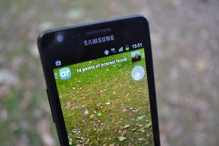
Landscape of the Vadastra village displayed on the mobile device
-
2.
Over the real landscape, the first triggered augmentation is a 3D object representing the virtual reconstruction of the prehistoric village (Figs. 15.5 and 15.6).
Fig. 15.5 
3-D augmentation: reconstruction of the prehistoric village
Fig. 15.6 
3-D augmentation: reconstruction of the prehistoric village
-
3.
Outside a 10 m radius around the starting point, within which the observer has the time to understand the general form of the settlement and his internal organization (floating over the contemporary landscape), the existing image is overlapped by another augmentation which becomes visible, i.e. the image of a prehistoric house (Fig. 15.7). This image is of a real house, constructed as an archaeological experiment, and is provided with an explanatory text and the suggestion to the viewer to scan the experimental prehistoric house.
Fig. 15.7 
Image augmentation: the experimental prehistoric house
-
4.
At this stage, the user has to toggle the application to the Image-recognition mode, scan the house and enter a more immersive experience, represented by a 3D virtual tour which leads him through the prehistoric house on a pre-defined route. There he/she will discover the details of the interior design and different household technologies, with the help of video films played sequentially. These films represent a re-enactment of prehistoric technologies: weaving with a horizontal loom (Fig. 15.8).
Fig. 15.8 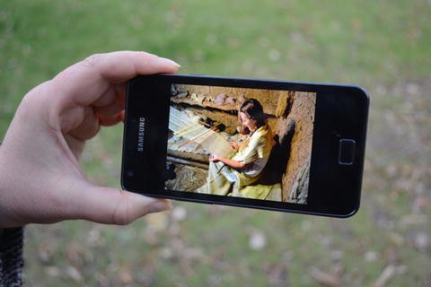
Video augmentation: weaving with a horizontal loom
-
5.
Following the visualization of the house’s interior, the user has to toggle back to the Geo-based mode. By moving the smartphone left and right, upwards and downwards, other images and 3D reconstructions of prehistoric objects (vases, textiles) (Figs. 15.9 and 15.10), manufactured with these technologies, and images of the technological instruments (kiln, loom) (Fig. 15.11) become visible.
Fig. 15.9 
Image augmentation: prehistoric vases
Fig. 15.10 
Image augmentation: prehistoric textiles inside the house
Fig. 15.11 
Image augmentation: prehistoric kiln
-
6.
Continuing the exploration, the visualization of each object is followed by a detailed display of its texture and color (Figs. 15.12, 15.13 and 15.14) covering almost the entire viewing area of the smartphone.
Fig. 15.12 
Image augmentation: prehistoric textures and colors (clay and straws)
Fig. 15.13 
Image augmentation: prehistoric textures and colors (decorated ceramics)
Fig. 15.14 
Image augmentation: prehistoric textures and colors (textile)
-
7.
After completion of this route, the application allows the visitor to re-access the map of the place (the Map View mode) and to once again visualize the POIs, repeating the immersive experience, or to quit the application.


9 The 3D Virtual Tour
To further expand the AR immersive experience on mobile devices we performed a hybridization of technologies and performed a mix of real and virtual media in a game-like environment. We chose Unity as an authoring tool for the AR experience, and as a real time engine, integrated with the Metaio AR functions.
We used an advanced functionality of the Metaio AR technologies, i.e. the 3D tracking using a 3D point cloud model of the prehistoric house. For this we pre-trained the point cloud of the model using a Metaio tool on Android devices (Fig. 15.15), available through the App Store.

3D point cloud model of the prehistoric house (Metaio Creator)
In the reconstructed interior of the prehistoric house, we defined touch sensitive zones, which upon clicking trigger videos displaying re-enactments of each technology.
10 The 3D Objects
For the 3D objects we used the Wavefront OBJ format, which is a high quality graphic data for static meshed-based objects. The models were optimized (as polygons and textures number, baked lighting a.s.o.) in order to reduce the costs when these models are downloaded from the remote database through mobile communications. The digital dimensions were correlated with the real ones, taking into consideration that 1 digital unit corresponds to 1 mm (in real physical measurements).
11 Discussion
The process of developing the AR experiment was a creative one both in the elaboration of the application concept and in the creation of the augmentations (e.g. videos, 3D modeling or images), which were implemented by artists and technicians.
The AR/MR technology allowed the mix of real and virtual worlds and brought about an augmentation of both. The techniques were the combination, in the same visualization, of the real environment and the virtual information, resulting in a new reality, complemented by annotating the real world portion of it with visual and textual information.
For the creative use of the AR technology potential, it is necessary to understand the AR processes in order to select the most adequate one for the application purpose. One of this is the tracking process. In our case, we decided to use location-based tracking and 3D cloud point modeling of a real object. The 3D tracking is an advanced method, which allows the AR applications to integrate naturally with the real world and thus avoid using markers or reference images. Metaio’s AR technologies implement this 3D tracking of pre-modeled objects.
To make the location-based AR an immersive experience, we displayed 3D objects, 2D images and artistic video films to augment the reality of a village landscape.
To enhance the immersive experience we decided to use the Unity gaming engine in an AR settlement based on image-recognition. The reconstruction of a 3D complex scene (the prehistoric house) benefited from special graphical effects (such as lighting). The experience is similar to that produced by a video game. Metaio’s SDK integrates with the Unity3d.
Our experiment benefited from the use of mobile devices which favor the mobility of the user, the enhancement of the exploratory AR experience (as a mix of art and science), and the wide scale implementation of open-air AR projects. The experience and its immersive effect can be further enhanced by using mobile devices with larger display screens, e.g., tablet PCs.
The Layar platform exploited in the first stage of our Art-chaeology experiment allows for rapid development and the testing of the technology, while Metaio’s technology and the Junaio browser provides advanced functionalities and the option of authoring complex AR applications. Furthermore, this platform allows the creation of video textures and linking of different AR channels in order to create complex story-based scenarios.
The application developed provided an interactive and engaging way of transmitting historical information.
Finally, our method and technology also had an educational impact on the viewers. The process of explaining the real environment with multimedia augmentations and the use of art as a vehicle for the transmission of information had a noticeable educational effect, especially on children.
The method proposed in this chapter, namely of exploiting the potential of augmentations in a fractal-like analysis, also demonstrated its pedagogical efficiency when applied to the Vădastra Primary and Secondary Schools, during the course of two campaigns in conducted in 2012 and 2013 (Fig. 15.16).

Educational experiment
12 Conclusions
The present paper offers an argument in favor of the importance of augmentation as an evocative instrument, in a mixed strategy combining art and science, as art-chaeology. It also presents the fractals as a possible augmentative process in this hybrid strategy.
From the point of view of visual art, the augmentation is an additive method that enriches a picture in a rhetoric manner. Artistic reconstructions of the experiments in the form of re-enactments also produced a powerful immersive effect when immaterial heritage was presented in its original contexts. And finally, colors and textures created artistic compositions of great aesthetic and immersive value.
As was apparent from the field validations, it can be concluded that the approach we propose, a fractal-augmentative manner, acted as an efficient educational tool, in which the AR has played the role of an “agent”. This “agent” provided contextual information, where the context was geographic, inertial or visual. This method can improve the understanding and retention of information and of the educational message.
From the application experimentation we can conclude that the augmentation of the contexts had a powerful impact on the observer, allowing a deeper understanding of immaterial heritage, and can be an educational and learning tool, as well as a method for future transmission. The complexity of the stored data collected from the archaeological record and archaeological experiments, combined with some artistic processes, gives Art-chaeology the opportunity to become a present-day working instrument for saving and transmitting immaterial heritage.
We can conclude that the augmentation itself can be an artistic process (i.e. ARt), with an, as yet still unexplored, art potential. The advantages of an application for smartphones and tablets is that it allows an experience of immersion and consequently of learning in the exact historical context and directly relates the observer to the archaeological record and immaterial heritage.
Notes
- 1.
- 2.
- 3.
- 4.
- 5.
- 6.
- 7.
http://www.hpl.hp.com/mediascapes HP Labs [accessed 1 Dec 2013]
- 8.
http://www.sitegallery.org/archives/3091 [accessed 7 Jan 2014]
- 9.
http://openarml.org/wikitude4.html [accessed 15 Oct 2013]
- 10.
https://research.cc.gatech.edu/kharma/ [accessed 7 Jan 2014]
- 11.
http://dev.metaio.com/arel/overview/ [accessed 7 Nov 2013]
- 12.
https://developer.qualcomm.com/mobile-development/mobiletechnologies/augmented-reality [accessed 1 Nov 2013]
- 13.
http://dev.metaio.com/sdk/getting-started/unity3d/running-the-tutorials-app/ [accessed 7 Nov 2013]
- 14.
www.poweredbystring.com [accessed 7 Jan 2014]
- 15.
References
Arth C, Schmalstieg D. Challenges of large scale augmented reality on smartphones, workshop ISMAR 11: enabling large-scale outdoor mixed reality and augmented reality basel, 26 Oct 2011 (2011).
Azuma RT. A survey of augmented reality. Presence: teleoperators and virtual environments 6, 4; August 1997. Malibu: Hughes Research Laboratories; 1997. p. 355–85.
Benford S, Giannachi G. Performing mixed reality. Cambridge, MA: The MIT Press; 2011.
Bimber O, Raskar R. Spatial augmented reality, merging real and virtual worlds. Wellesley: A. K Peters; 2005.
Bonde S, Houston S. Re-presenting the past. Archaeology through text and image. Oxford/Oakville: Oxbow; 2013.
Bradley R. Image and audience. Rethinking prehistoric art. Oxford: Oxford University Press; 2010.
Brogni A, Calwell DG, Slater M. Touching sharp virtual objects produces a haptic illusion. In: Shumaker R, editor. Virtual and mixed reality new trends. Berlin/Heidelberg: Springer; 2011. p. 234–42.
Brown CT, Witschey WRT, Liebovitch LS. The broken past. Fractals in archaeology. J Archaeol Method Theory. 2005;12(1):37–78.
Burghelea V, Melinescu A, Brăileanu A, Gheorghiu D, Lăbus A. The ceramics of the Chalcolithic Vădastra culture, key engineering materials. Euro Ceram VII. 2001; 206–13.
Butchart B. Augmented reality for smartphones – a guide for developers and content publishers. JISC Observatory. 2011.
Chandler D. Semiotics. The basics. Abington: Routledge; 2007.
Clifford J. On ethnographic allegory. In: Clifford J, Marcus GE, editors. Writing culture. The poetics and politics of ethnography. Berkeley/Los Angeles/London: University of California Press; 1986.
Craig AB, Sherman WR, Will JD. Developing virtual reality applications. Burlington: Morgan Kaufman; 2009.
Ede S. Strange and charmed. Science and the contemporary visual arts. London: Calouste Gulbenkian Foundation; 2000.
Geroimenko V. Scope, cabinet exhibition, peninsula arts gallery, 14 May–25 June. http://www.geroimenko.com/Scope-Augmented-Reality-Artwork-at-Cabinet-Exhibition 2011. Accessed 1 Dec 2013.
Geroimenko V. Four key words lost in augmented reality: a VR-based digital photo painting with a hidden AR object. In: 16th international conference information visualisation, Montpellier. http://www.geroimenko.com/Four-Key-Words-Lost-in-Augmented-Reality-D-ART-Online-Gallery-France-July-2012-June-2013 (2012). Accessed 1 Dec 2013.
Gheorghiu D. Le projet Vadastra, Prehistorie Européenne. Liège: Université Libre de Bruxelles; 2001. p. 16–7.
Gheorghiu D. Art-chaeology. A sensorial approach to the past. Bucharest: UNArte; 2009a.
Gheorghiu D. De l’objet à l’espace: Une expérience art-chéologique de la préhistoire. Etudes Balkaniques (Cahiers Pierre Belon 15), Paris; 2009b. p. 211–24.
Gheorghiu D. A study of art-chaeology, Centro Studi Archeologia Africana, Archeologia Africana – Saggi occasionali 2005–2009, (11–15). Milan; 2009c. p. 45–50.
Gheorghiu D. Experimenting with prehistoric spaces (Performance, experience, evocation). In: Nash G, Gheorghiu D, editors. The archaeology of people and territoriality. Budapest: Archaeolingua; 2009d. p. 235–54.
Gheorghiu D. The technology of building in chalcolithic southeastern Europe, p. 95–100. In: Gheorghiu D, editor. Neolithic and chalcolithic architecture in Eurasia: Building Techniques and Spatial Organisation. Proceedings of the XV UISPP World Congress (Lisbon, 2006 Sept 4–9)/Actes du XV Congrès Mondial (Lisbonne, 2006 Sept 4–9), Vol 48, Session C35, p. 95–100. BAR International Series 2097. Oxford: Archaeopress; 2010.
Gheorghiu D. Metaphors and allegories as augmented reality. The use of art to evoke material and immaterial objects. In: Back-Danielsson I-M, Fahlander F, editors. Encountering imagery. Materialities, perceptions, relations, Stockholm studies in archaeology, vol. 57. Stockholm: Department of Archaeology and Classical Studies, Stockholm University; 2012a. p. 177–86.
Gheorghiu D. eARTh vision (Art-chaeology and digital mapping). World Art. 2012b;2(2):211–7.
Gheorghiu D, Children G, editors. Experiments with past materialities, British archaeological reports international series 2302. Oxford: Archaeopress; 2011.
Gheorghiu DS, Ştefan L. In between: experiencing liminality. In: Aceti L, Rinehart R, editors. Not here, not there. Leonardo Electron Alm;19(1). Istanbul: Sabanci University; 2013a. p. 44–61.
Gheorghiu D, Ştefan L. The maps of time project: a 4D virtual public archaeology (poster). In: 19th EAA annual meeting 2013. Pilsen, Czech Republic, 4th–8th Sept 2013; 2013b.
Huys V, Vernant D. L’Indisciplinaire de l’art. Paris: Presses Universitaires de France; 2012.
Ifantidis F. Archaeographies. Excavating neolithic dispillo. Oxford: Archaeopress; 2013.
Karlekar J, ZhiYing Zhou S, Lu W, Nakayama Y, Hii D. Mixed reality on mobile devices. Singapore: Interactive Multimedia Lab., Dept. of ECE National University of Singapore; 2010.
Mandelbrot BB. The fractal geometry of nature (Updated and augmented edition). New York: W. H. Freeman; 1983.
Mandelbrot B. interviewed by Anthony Barcellos. In: Albers DJ, Alexanderson GR, editors. Mathematical people: profiles and interviews. Wellesley: AK Peters; 2008. p. 213–34.
Mateescu C. Contribution to the study of Neolithic dwellings in Romania. A dwelling of the second phase of the Vadastra culture. Dacia NS. 1978;XXII:65–71.
Mathieu JR. Introduction: experimental archaeology. Replicating past objects, behaviors and processes. In: Mathieu JR, editor. Experimental archaeology. Replicating past objects, behaviors and processes, British archaeological reports international series1035. Oxford: Archaeopress; 2002. p. 1–12.
Milgram P, Kishino AF. Taxonomy of mixed reality visual displays. IEICE Trans Inf Syst, E77-D (12). 1994. p. 321–1329.
Mullen T. Prototyping augmented reality. Indianapolis: Wiley; 2011.
Papagiannakis G, Schertenleib S, O’Kennedy B, Arevalo-Poizat M, Magnenat-Thalmann N, Stoddart A, Thalmann D. Mixing virtual and real scenes in the site of ancient Pompeii. Comput Anim Virtual Worlds. 2005;16(2):11–24.
Paul C. Digital art. London: Thames and Hudson; 2011.
Pink S. The future of visual anthropology. Engaging the senses. London/New York: Routledge; 2006.
Reid J, Geelhoed E, Hull R, Cater K, Clayton B. Parallel worlds: immersion in location-based experiences. Proceedings of the SIGCHI conference on human factors in computing systems, New York; 2005. p. 1733–6.
Renfrew C. Figuring it out. The parallel vision of artists and archaeologists. London: Thames and Hudson; 2006.
Suderburg E. Introduction: on installation and site-specificity. In: Suderburg E, editor. Space, intervention. Situating installation art. Mineapolis: University of Mineapolis Press; 2000. p.1–22.
Tyler S. Post-Modern ethnography. From document of the occult to occult document. In: Clifford J, Marcus GE, editors. Writing culture. The poetics and politics of ethnography. Berkeley/Los Angeles/London: University of California Press; 1986. p. 122–40.
Vico G. The new science. Ithaca: Cornell University Press; 1744. 1968.
Vlahakis V, Ioannidis N, Karigiannis J, Tsotros M, Gounaris M, Stricker D, Gleue T, Daehne P, Almeida L. Archeoguide: an augmented reality guide for archaeological sites. IEEE Comput Graph Appl. 2002;22(5):52–60.
Wagner D. History of mobile augmented reality. Christian Doppler Laboratory for Handheld Augmented Reality, Graz University of Technology, Austria; 2005.
Zubrow EBW. Fractals, cultural behavior, and prehistory. Am Archeol. 1985;5(1):63–77.
Acknowledgments
The authors thank Dr. Vladimir Geroimenko for the kind invitation to contribute to this book, and Professor Andreea Hasnaş, Assistant Professor Alexandra Rusu and technician Elena Hăut (NUA) for their collaboration. Last, but not least our gratitude goes to Mr. Bogdan Căpruciu for his review of the English text.
The project was financed by an exploratory research grant PN II IDEI (“The Maps of Time. Real communities, virtual worlds, experimented pasts”, Director Professor Dragoş Gheorghiu). Images by D. Gheorghiu.
Author information
Authors and Affiliations
Corresponding author
Editor information
Editors and Affiliations
Rights and permissions
Copyright information
© 2014 Springer International Publishing Switzerland
About this chapter
Cite this chapter
Gheorghiu, D., Ştefan, L. (2014). Augmenting the Archaeological Record with Art: The Time Maps Project. In: Geroimenko, V. (eds) Augmented Reality Art. Springer Series on Cultural Computing. Springer, Cham. https://doi.org/10.1007/978-3-319-06203-7_15
Download citation
DOI: https://doi.org/10.1007/978-3-319-06203-7_15
Published:
Publisher Name: Springer, Cham
Print ISBN: 978-3-319-06202-0
Online ISBN: 978-3-319-06203-7
eBook Packages: Computer ScienceComputer Science (R0)