
Abstract
This book chapter provides immense documentation of Himalayan foredeep neotectonics and evolutionary processes that focus on landform deformation and channel succession in terms of morphotectonic discussion at a glance. The Himalayan foredeep foothill is composed of successive sediment deposition of 16.0–0.5 Ma BP i.e. Middle Miocene-Middle Pleistocene and late Quaternary Siwalik, which is overlain by young thick sandy to loamy sediments of Holocene near surface (Jain AK, Banerjee DM, Kale SV (2020) Tectonics of Indian subcontinent, society of earth scientists series, ISSN 2194-9204 ISSN 2194-9212 (electronic), ISBN 978-3-030-42844-0 ISBN 978-3-030-42845-7 478 (eBook), 111–433. 10.1007/978-3-030-42845-7). This elongated section is formed by series of alluvial fans, which are deformed and restructured by the neotectonic activities evident by earthquake magnitude in the last 120 years with the presence of Matiali scarp (MBT) 34 ka, Chalsa scarp (MFT) 11–6 ka (Kar et al. Geomorphology 227:137–152, 2014). The MIS-3(marine isotope stage 3) of 34 ka (Mukul M, Singh V (2016) Active tectonics and geomorphological studies in India during 2012–2016. In: Proceedings of the Indian national science academy, p 82 10.16943/ptinsa/2016/48480) initiated the alluvial fan formation (Matiali fan) which had been interrupted by repeated tectonic activities and accompanied by hydrological flow alteration due to climate change as the emergence of LGM (Last Glacial Maximum) and MIS-2 in Holocene (Martinson et al. Quatern Res 27:1–29, 1987). Upliftment and erosion sequences assemblaged by slope differentiation and flow/velocity alteration prompted the reframed alluvial fans and two tire river terraces. The alluvial fan in a fan formation extended towards the south with distinctly identified three geomorphic units as apex, mid fan, and lobes. These fans are cast around as mega fans and meso to micro-scale dimensions. The outcome of the study is recapitulated in one pictorial image to make a clear understanding of its morphological units. In the field, artificially initiated water flow in varying discharge (Q) has been experimented to set an idea of expanded coverage area in both monsoon and flood seasons. The morphotectonic indices on River Kaljani specify the active tectonics over the area where fans have developed in an elongated shape with changed SL and concavity along the channel. It is a comprehensive study of foreland active tectonics of North Bengal foothill. It clarifies the mechanism of deformed landforms and modification of channel succession in response to the active tectonics.
Access provided by Autonomous University of Puebla. Download chapter PDF
Keywords
1 Introduction
The collision of the Indian plate with Asia is well known as the highest, youngest one continental collision orogenic belt where the Siwalik foredeep basin along the southern west- the east boundary of the Lesser Himalaya specify the erosional history of the uplift and exhumation of the Himalaya since collision (Garzanti 2019). The northward progression of the Indian plate into the Eurasian plate is evident, as we study topography, geology, earthquake events, and deformation (Wesnousky et al. 1999) mechanism over time. The Himalayan thrust sheets shingled together since ~58 Ma consist of South Tibetan detachment (STD), Main Central Thrust (MCT), Main Boundary Thrust (MBT), and Main Frontal Thrust (MFT) from north to south (Fig. 1a) (Saha 2013 and DeCelles et al. 2016). In the Late Pleistocene to Holocene, along the active fault lines in the southernmost foredeep section of the Himalayan arc, the geomorphic deformation took place. The East–West trending Himalayan hillyscape is diversely delineated from north to south by major thrust lines as MCT, MBT, and MFT. The tectonic anomalies transport Upper Pliocene—Lower Pleistocene Siwalik succession over the Middle Pleistocene—Holocene sediments of the Indo-Gangetic plains (Nakata 1972) in the foreland area.

a Arc shaped Himalayan mobile belt with major sections from North to South (Saha 2013). STD-South Tibetan detachment, MCT-Main Central Thrust, MBT-Main Boundary Thrust, HFT- Himalayan Frontal Thrust. b North–South geological cross-section with major Thrusts and expanded foreland area towards south of the MFT (Main Frontal Thrust)
According to Mukul (2000), Chaudhri and Chaudhri (2001), Valdia (2003), Thakur (2013), Srivastava et al. (2016), the most deformed Quaternary deposits are found between the Main Boundary Thrust (MBT) and Main Frontal Thrust (MFT) are significantly deformed resulting landforms like fans and terraces due to active tectonics (Biswas and Paul 2020) and surface rupture. The softer sediments detached from the basement in terms of basal decollement due to the slipped MFT plane into the Himalayan edges during folding (Lave and Avouac 2000; Kumar et al. 2012). The thin-skinned model define that the faults are initiated from the basal decollement and accumulated strains that released during the earthquakes (magnitude >7.89). It is defined by Lave and Avouac (2000), Mugnier et al. (2013), that such an earthquake unlocks the trapped MFT sediment sequences and insists mobilization towards the foreland Himalayan ranges. Therefore, the development of foreland basin with landform deformation are associated with Holocene tectonic activities near MFT and MBT (Saha 2013; De Celles et al. 2016) (Fig. 1b).

Interpolated Earthquake magnitude map of North Bengal foot hill and its adjacent Hilly terrain of Himalaya. Based on earthquake magnitude data from (USGS Bulletin, 1900–2019) https://earthquake.usgs.gov/earthquakes/search/
The foreland topography dissected by foothill rivers bears the neotectonic evidence which is also accompanied by seismological attestation. The Holocene neotectonics have deformed the alluvial fans forming T3/T2 (T=Terrace) along the active parts of the rivers where T4 is fan surface. The Quaternary active fault scarps are exposed as the sediment sequences of conglomerate which is overlain by recent sediments and studied during fieldwork. After river Torsa, MFT and MBT are abrupt, visualized and channels are successively incised that may be re-examined by morphotectonic analysis (Biswas et al. 2021). The MFT and MBT are widely spaced until Torsa and later they share a very narrow space between them. The flat synformal axial zone between MBT and MFT is characterized by deformed landforms due to Quaternary tectonics. Landforms like alluvial fans and river terraces have developed (Kar et al. 2014) in this area in between Matiali fault (MBT) and Chalsa Fault (MFT). The formation of such scarp surfaces along the foothills suggests the orogenic movement.
The foothill river systems flow down huge sediments with a compilation of gravel and boulders carried out from the outer Himalayan ranges at the beginning of the Quaternary period insisting to the formation of alluvial fans. Thereafter, the active orogenesis insisted the upliftment/incision process led to the further deformed morphological layout of the area. Such active (Gansser 1964) belt of the Himalaya address an interlinking between uplift, erosion, climatic variation, etc. (Lave and Avouac 2000; Bookhagen et al. 2005; Wobus et al. 2006; Srivastava et al. 2016; Singh et al. 2016) that have controlled the syn-depositional and post-depositional tectonic events. It correlates the erosional cycle and valley deepening of the Pleistocene to Holocene. The foredeep neotectonics is evident as assimilation of uplift–erosion sequence of channels that dissect the alluvial fans with the progression of river terraces.
The present study is an attempt to decipher the effect of active tectonics of the North Bengal foredeep area and development of deformed alluvial fan surfaces (Biswas 2014) with topographic dynamics of the Himalayan edge of the foreland area in the context of active faults and lineaments. Secondly, a case study of River Kaljani (Torsa system) has been analyzed in an integrated way that elucidates the geomorphic, linear, and basin-scale parameters.
2 Study Area
2.1 Location
The entire foredeep area is drained and dissected by a number of parallel N-S flowing rivers and their tributaries. Broadly, they are under the Brahmaputra River system with several sub-systems, based on particular major river such as the Teesta, Jaldhaka, Torsa, Raidakh and Sonkosh. All the rivers are originated from the middle or higher Himalaya and flow down slope to meet the Brahmaputra.
2.2 Regional Geology
Unlike the continuous range of Himalaya of North Bengal, the foothill sediments are the part of a sub-Himalayan tectonic zone (Gansser 1964; Naldtiyal et al. 1964; Jangpangi 1974, Kale et al. 2014) delineated by MBF. Regarding the geological formations like Baikunthapur and Chalsa formation over the entire piedmont zone, there is no remnant of glacial action, but Mallet (1975) and Bisaria (1980) noted massive aggradations, which is uncommon in the Eastern Himalayan rivers. Later on, the fluvial channels (Jain et al. 2016) transport an investigation on the prominence of rock fragments. In Fig. 2, the spatial distribution of earthquake magnitude (3–4) reveals the paleoseismic occurrences from 1900 to 2019 in the North-Eastern part of the Himalaya. It shows a low contour value trending W-E portraying seismic gap thus implying large magnitude earthquake in future.
In general, the rivers flowing down to the lower floodplains of North Bengal have deposited the fine grain sediments, originated due to the denudation process of catchment rocks. It is also associated with the deposits ranging from cobble to clay size materials that overlie the area during the high flow and low flow period. Besides, the scarp faces (terrace scarps) cut by fluvial activity, another set of scarps (piedmont scarps) are observed towards the south, due to the presence of local fault scarp like Baradighi.
These run across the trend of the rivers and impart a step like appearance to the landscape. The intensive interaction of endogenic (related to Himalayan upheaval), mesogenic (reactivation of lineaments) and exogenic (surfacial morpho-dynamic processes including accommodated landmass) factors during the Quaternary period has resulted in the formation of six aggradation terraces in the area i.e. the terrace sediment accumulation has happened mainly during the floods as huge sediments are discharged accompanied by flood scourge and filling (Biswas and Banerjee 2018; Paul and Biswas 2019). The southern flank of the Himalayan orogeny is highly affected by the MBT that has carried the Gondwana series and overlain the Tertiary Siwalik sedimentary layers at its foothills (Gansser 1964; Yin 2006; Mukherjee et al. 2015). The quaternary deposits near MFT is under the Siwalik group and composed of recent alluvium sediment sequences of different grain size (Nakata 1972, 1982, 1989; Hodges 2000; Yin 2006; Jain et al. 2020). This area comprises the Main Boundary Thrust (MBT) and the Main Frontal Thrust (MFT) with a number of lineaments having both geomorphic and structural linkages (Fig. 3). Along with the major E-W aligned fault lines, there are faults like Gish transverse fault, Madhupur fault, Dhubri fault that are transverse to the Himalaya and these have revised the channel morphometric indicators to be an intended anomalies along the channel (Srivastava et al. 2016; Ayaz et al. 2018).

The MBT and the MFT from the Lish to Diana are widely spaced towards the east along the E-W trend thrust lines on the foredeep area, which are confined and exposed in northward dipping MBT near Matiali and the MFT near Chalsa (Kar et al. 2014). Besides these two, there is east–west trend GT (Garubathan Thrust) in the north of the Matiali thrust, near Samsing which is successively overlain by Matiali formation near Matiali bazar (left bank of Kurti river, downward side of Shiva temple). Towards east, MBT is continued into two lines, as Jiti fault in north and Thalhjora thrust in south. Though, both Matiali and Thaljhora thrust belong to the MBT (Nakata 1982), but the Matiali is a fore thrust blind fault dipping towards the north and the Thaljhora is the back thrust, dipping towards the south (Chakrabarti Goswami et al. 2019). Between MBT and MFT exists a deformed landscape (Kar et al. 2014) of synformal zone that developed between the Mal and Murti River and distinctly observed near the Kurti (near Matiali school) and the Murti River (polo ground) as mentioned before.
The Neotectonics of this foreland basin comprises drainage modifications and valley incision (Biswas 2015). This area is also characterized by the overlapping of fan surfaces, promoted by sediments carried by individual rivers and channels. Nevertheless, during 24–18 ka with the substantial decrease of discharge, some fans were abandoned (Mukul and Singh 2016) and lobes have become stable as there was no such aggradation process taking place. There are some meso level fans that are active and proceed in response to slope and their hydro-sediment flow behaviour (Ayaz et al. 2018) and deformed by Quaternary tectonics like activation of Chalsa fault (~90 m elevated) during 11–6 ka (Mukul and Singh 2016).
Broadly, the Himalayan belt had been formed between 65 and 55 Ma or more specifically 53.3 ± 97 Ma when the genesis was accompanied by subduction of the Indian lithosphere beneath the Asian plate (Jain et al. 2020). The foreland strip from the Teesta to Kameng river is under the Miocene–Pliocene Siwalik group and is composed of sediments during 13–7 Ma and <2.6 Ma (Jain et al. 2020). However, the Quaternary deformation mechanism is evident over the foredeep area with the geomorphic processes, controlled by Himalayan tectonics has propagated to great extent (Guha et al. 2007).
This riverscape is manifested by surface rupture, which is caused by the tectonic events and the active faults (MBT and MFT) that act as the respondent (Singh et al. 2016). De Celles et al. 2016 argued that the Himalayan front evolved like a bowl-shaped sedimented basin being characterized by low gradient foredeep. The mountain fordeep section is overlapped with meso level alluvial fans, (Ayaz et al. 2018) fed by parallel rivers originated from the Himalayan. The MBT and MFT are the two asymmetrical folds with blind faults which have not yet been exposed on the surface (Goswami et al. 2013). Indeed, only the minor displacement and cross-bedding of sediment, flow is noticeable in the exposed part. Kar et al. (2014) and Ayaz et al. (2018) depicted the alluvial fan morphology through the morphotectonic analysis of both fans and channels including Quaternary evolution where the entire foredeep area encompasses the deformed landscape as terraces (Ghosh and Paul 2020).


a Expanded Alluvial fan formation in the part of foreland area (Biswas 2009). b Undulation Foreland basin with Gish Transverse Fault and Alluvial fans with distinct lobes in Neora-Murti interfluve area (Biswas 2009). c Field based (2018) Micro scale Fan modelling with lobe identification and graphical representation of different morphological parts of fan. d Understanding of flow behaviour on fan shaped micro landscape through an application of manual flow modelling using soluble Potassium Permanganate with water in respective time gap. (Based on field experiment). e Elongated shaped Alluvial Fan of Kaljani River with 5 identified lobes as 1–5 (marked in red colour); extracted from SRTM data and faults/lineaments are based on Saha and Bhattacharaya 2019
The Himalayan active neotectonics is strongly related to the seismic activity in the study area (Starkel et al. 2008). The N-E trending contours of negative Bouguer gravity anomaly (−180 to −160 m Gal) pass-through this area (Dasgupta et al. 2000). The seismic activity is associated with the MBT and tear faults. It focuses on the Nepal-Bihar earthquake in 1934 and 1988 indicating the thrusting with a strike-slip component. Study of microearthquakes are intimated with the seismic gap transverse to the MBT (Gupta and Srivastava 1992; Srivastava et al. 1976; Ichikawa et al. 1972). The high convergence rate of the Higher and the Frontal Himalaya including the active Gish transverse fault zone specifies the tendency to stimulate earthquake (Mullick and Mukhopadhyay 2011). This active foreland basin is also marked by the recorded evidence of a great earthquake around A.D. 11 which was reinterpreted around A.D. 1255 (Mishra et al. 2016). Pierce and Wesnousky (2016) argued that the earthquake of A.D. 11 was an indication of active tectonics along the MFT and MBT zone of Chalsa fault displacement as the fore thrust and Thaljhora as the back thrust (Chakrabarti and Goswami et al. 2019).
3 Materials and Methodology
This book chapter has been formulated on the basis of three broad sections of data sets.
-
The basic geological setup of the area has been studied from the geological map, the broad geological section from the Geological Survey of India, Quaternary Division, Kolkata as well as from published secondary sources. The tectonic setup has been analysed with the help of faulting and folding of the area along with fault scarp delineation. Accumulated data and modified figures from secondary sources as literature, reports, documents, published papers have been re-examined. Seismological magnitude data have been collected from USGS Bulletin, 1900–2019.
-
Field based data collection, physical modeling and micro scale understanding of landform have been incorporated during 2015 and 2018 field trips.
-
For morphotectonic analysis of the concerned basin, SRTM 90 m resolution DEM has been considered. We obtained the DEM as a Geo Tiff raster file and clipped according to the basin area. Each error of the ICPs was considered by converting the C30 geoidal heights to ellipsoidal heights (Mukul et al. 2014 and Mukul and Singh 2016).
Subtracting them from the corresponding ICP RTK ellipsoidal heights, the obtained errors were then subjected to correction for maintaining accuracy and uncertainty of C30 DEMs in the study area. The mean error (ME), mean absolute error (MAE) and root mean square error (RMSE) have been calculated to analyze the accuracy of the C30 data. Then the re-sampled mean corrected 30 m resolution SRTM data have been used to delineate the Kaljani Basin as well as the considered foredeep section of the Himalaya where the distinct drainage orientation of the area is well distinguished. Apart from the geological and tectonic setup, other selective morphometric indices have been calculated accordingly to analyse the imprint of neotectonism over the study area in a simplified manner. To assess the active tectonic channel, morphotectonic analysis has been adopted using the parameters on both linear scale and basin scale.
Linear indicators such as a longitudinal profile in terms of the linear, logarithmic, exponential, power curve, concavity, SL index, SI and T (Transverse topographic symmetry factor). Table 1a and basin-scale parameters as Hypsometric Integral (Hi), Form Factor (Rf), Elongation ratio (Er), Circulatory ratio (Cr), Tilt angle, and Ruggedness number have been calculated (Table 1b). Selected parameters have been applied to the basin of River Kaljani, the left side (East) tributary of the Torsa. All the layout of the analysed data have been reframed using different platforms as Arc GIS 10.4.1, Surfer 11 and Mat lab 15.
4 Neotectonic Movements, Landform Genesis and Channel Evolution
The entire drainage pattern of the foreland basin is a constituent of series of alluvial fans which are successively formed by the huge sediment aggradations. Quaternary tectonic activity has deformed the fan surfaces initiating the valley incision process resulting in the genesis of river terraces where the Fan surfaces remain as T4. Indeed, the upliftment and valley incision process enforced the formation of river terraces. Both the linear channel morphometry and basin-scale areal aspects display the anomalies and specify the active tectonics.

North to south Geological Section of Murti Boulder Bed, West bank of Murti River based on GSI Quaternary Division 2003, (Biswas 2009)

a SRTM base formulation of 3D mesh of the Foreland area with distinct identification of Alluvial fans with Matiali scarp (MBT) and Chalsa Scarp (HFT). b Photographic evidence of synformal zone before Chalsa scarp with northerly sloped T4 (fan surface) between Matiali and Chalsa scarp. (Goswami et al. 2013). c East-West transverse profile from Neora to Kurti River showing both T4 and T2 (Goswami et al. 2013) embedded with photographic evidences of T2. d Identified River terraces as T 2 and T1 in both side of River Kurti near Matiali High School with Fan surfaces
4.1 Deformed Landforms and Micro-scale Physical Modelling of Alluvial Fans
This tectonic imprint in landform deformation among the other factors is well observed along the entire foothill that encompasses meso level fans, formed by the transportation and aggradation mechanism of individual rivers having their own water and sediment discharge capacity (Fig. 4a, b) in respect of climate change. The sediment flow and depositional history of Matiali fan area initiated in 34 ka (Mukul and Singh 2016) that coincided with the emergence of the Indian Monsoon as MIS-3(marine isotope stage 3). But, during 24–18 ka, the rainfall decreased enormously in LGM (Last Glacial Maximum) having an effect on the nature of the hydro-sediment flow of the rivers. In MIS-2 and post-glacial Holocene MIS-1 (Martinson et al. 1987), substantial increase of rainfall-induced the volumetric change of water and sediments that initiated the vertical valley incision forms, the T2 and T1, near 12 ka (Mukul and Singh 2016). Regarding the hydrological and morphological alterations, fans where reframed and developed in a wide shaped poplar with a number of lobes, being incorporated as undulated foreland fan-in-a fan formation (Fig. 4a, b).
This discussion further includes the micro-scale fan identification and their conceptual understanding through a physical model. During the fieldwork, the present workers have identified micro-scale fan formation in the left side of Khuji Diana River where two minor non- permanent channels as C1 and C2 (Fig. 4c) have developed their individual fans distinctly. Through the measurement and quantification in two consecutive fans identified as A1 and A2 in Fig. 4c have a number of lobes with a maximum length of 1.079 m and 1.336 m. In A1 fan, there are three lobes as Lobe 1, 2 and 3 respectively having different widths from apex to lobe. Similarly, in Fan A2, only two lobes are prominent in an elongated shape with varying widths from apex to lobe. The physical micro-scale entities may be considered as the conceptual model of common fan series that have been developed in the concerned section of the foredeep area. In Fig. 4c, individual lobes have been marked focusing on fan apex, mid area and distal part. Massive aggradation mechanism has been enhanced by the flow behaviour of the channels and their tributaries over time; especially during the monsoon and extreme climatic condition like flood, when huge sediments were carried by the rivers that developed the fans and active lobes.
During the fieldwork, another physical flow modelling technique was adopted using potassium permanganate with water manually to understand the fan formation (Fig. 4d) in different stages. The results show that water coverage area during monsoon has increased as well as during flood period in stages 4. The alluvial fans in the entire Himalayan Foothill have been developed in this sequence and Quaternary tectonic activities have deformed the fans. The quantification of fan lobe geometry includes the measurement of flow angle, gradient of each lobe considering its maximum length and width that may be discussed under fan morpho-geometry (Fig. 4d). In respect of the above discussion, five fan lobes have been delineated from the Kaljani River Basin where each tributary having their own hydro-sediment discharge contributed in shaping the lobe orientation and eventually they are associated with lineaments and faults in the foredeep section resulting in channel anomalies (discussed later) (Fig. 4e).
The elongated North Bengal foothill area gives immense progressive knowledge about the deformed landforms. In this active area, southerly sloped alluvial fans are dissected by north to south flowing rivers and interrupted by east–west trend Matiali scarp in the north and the Chalsa scarp in the south. Towards the western part of the Murti River, lineament is better to understand as N-S trending Murti Boulder Bed and the geological section depicts the antiform folding with blind fault, which is not exposed on the surface (Fig. 5). Here, the MBT and the MFT are widely spaced having a synformal axis between them (Kar et al. 2014) where the fan surface got deformed and terraces formed on both sides of the River Kurti near the Matiali high school (Fig. 6a). However, the alluvial fans are less deformed where MBT and MFT are closely spaced and no synformal axis has developed. But river like the Kaljani is strongly controlled by the E-W aligned lineaments and N-S trend transverse to the Himalaya fault line as the Madhupur fault (Saha and Bhattacharya 2019). According to Goswami et al. (2013) apart from these E-W MBT and MFT, there are two other scarps; one is near the Neora River (East bank) and another NNE–SSW scarp as the Murti lineament. During the fieldwork, it has been noticed at the East bank scarp of Neora river near the railway bridge is a part (Western) of Chalsa scarp (Fig. 6b, 6c embedded image near Neora River) where sediment facies are distinctly displayed.
4.2 Morphotectonic Analysis
The computed results of geomorphic indices from re-sampled and corrected SRTM have been discussed in a conjugative manner. Figure 7 shows the major fault lines (Madhupur and Dhubri fault having south to north orientation and MBT, MFT and MCT having east to west orientation), the number of lineaments of the basin, and those adjacent to the basin area where both geomorphic and structural lineaments are present. The structural lineaments are mostly having orientation from east to west and the geomorphic lineaments exist in different directions. These faults and lineaments are accompanied by eleven recognized geological formations (Fig. 8) where Baikunthapur and Chalsa formations are under the foredeep Quaternary section and consist of a number of lineaments with their substantive imprint on both channel and basin morphometry.

(Based on Saha and Bhattacharya 2019)
Major lineaments and thrusts over the considered Kaljani Basin.

(Modified from Long et al. 2011)
Major Geological formations of Kaljani Basin.
-
Elevation profile: The extracted elevation profile shows the existence of Quaternary fault scarps in the foreland basin. If the drainage area from Chel to Torsa and Torsa to Sankosh is differentiated, the North to south aligned elevation profile distinctly displays the MFT and the MBT in the form of fault scarps; though they both are blind antiform between Mal and Murti River. Figure 5 illustrates the above fault scarps between the Matiali and the Chalsa scarp; both being northerly dipping and blind in nature. The distinctly identified scarps define the intermediate Synformal axis where river terraces have formed in upliftment/incision mechanism near Matiali School on the River Kurti.
-
Long profile and Hack profile analysis: Long Profile of the river along with various trend lines with calculated R2 values also assess tectonism. The positive R2 of logarithmic, exponential and power curves (Fig. 9) denote the active tectonics affecting the channel morphometry. The overlaying of actual and computed curves after 40 km from the source that makes an outline of the erosion/deposition alteration mechanism of the channel itself. The active tectonism of the region is evident in Hack profile where the channel is convex in shape (R2 0.777) determining the erosive nature of the channel and also signifying some disturbances of the particular region due to neotectonic activity (Fig. 10). The lower reach of the river is typically characterized by a gentler gradient as it is representing a concave up profile as shown in the Hack Profile signifying depositional activity.
Fig. 9 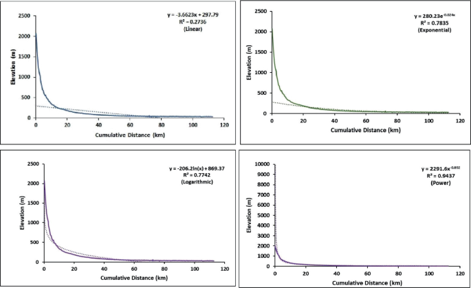
Longitudinal Profile of Kaljani River with Linear, Exponential, Logarithmic and Power curves where the R2 value of exponential, logarithmic and power curves are highly positive that specify the active tectonics
Fig. 10 
Hack Profile of Kaljani River shows the convex shape that depict the erosional tendency of the river
-
SL and Concavity: Fig. 11 is a combined diagrammatic representation of SL index and concavity. SL index was used by Keller and Printer in 2002 to assess the relative tectonics of any area. Here, the values vary from 317.742 to −5.8967 along the long profile in different studied points of Kaljani River. Random alteration of values denotes the active tectonics. The recent tectonics is marked by the higher values as observed in the upper part of the Kaljani River due to the presence of MCT and MBT. Inconsistently, the lower values in the downstream section pertain to the presence of joints, cracks, faults and lineaments along the stream or transverse the river flow path. It is also associated with concavity index that specifically refers to the tectonic activity in accordance with the gradient and erosion probability of the River Kaljani. Both the indices indicate that the foredeep area is tectonically active and broadly under the Baikunthapur and Chalsa formations are dominated by steep channel gradient and debris flow.
Fig. 11 
Assessment of SL index and concavity of River Kaljani along the long profile to determine the anomalies. (Data extracted from SRTM data)
-
Sinuosity Index (SI): Changes in channel orientation with tectonic disturbances and valley slope change enhance the channel pattern as straight to sinuous, sinuous to meandering and etc. to encounter its threshold. Pike and Wilson in 1971 applied the Hypsometric Integral (Hi) and Relief Ratio in discussing tectonics in a basin area. Near foothill, the SI value decrease (1.0) and further downstream it increases substantially up to 2.4 i.e., meandering. The SI values indicate down cutting where the channel in a straight manner due to incision. It is depicted by the SI that the channel is regulated by its changing flow pattern and volume when it passes through the weak zone termed as faults, lineaments or fractures. Such slope alteration induces vertical incision of the channel with higher velocity than lateral erosion resulting in straight to sinuous channel.
-
T (Transverse topographic symmetry factor): It is a basin morphometric indicator that portrays the symmetry of the basin in reference to its midline. It is applicable to measure the perfect symmetry to asymmetry (0–1) of the basin. Considering the studied points in Kaljani basin up to 26.55 N/89.41E, the values are higher indicating river oscillation and maximum shifting in response to tectonic tilt after which the values have decreased due to minimum tilt. But in 26.39 N/89.56E, 26.35 N/89.57E and 26.27 N/89.58E alteration of higher values encompasses the asymmetric nature of the basin. These results bespeak the tectonic imprint of the entire basin, especially in the lowermost foreland area.
-
Elongation Ratio, Form factor and Circulatory Ratio: According to Pareta and Pareta 2011; value >0.7 refers to elongated, 0.7–0.8 as less elongated, 0.8–0.9 oval and 0.9–1.0 as circular. The Kaljani river basin is elongated in nature as the value is 0.57 which again suggests the basin as active. The value of the form factor is 0.25 that positively matched with the elongation ratio indicating as positive feedback system. Continuing such quantification, elongated basins become circular when tectonic activities diminish and with time topographic evolution takes place. It is noticed when channel widths increase, indeed, the circularity value as low as 0.28 indicates active tectonics.
-
Hypsometric integral (Hi) and Tilt angle: Hypsometric integral (Hi) correlates height (h/H) versus relative area (a/A). The Hi value ≤0.30 states tectonically stable basin and ≥0.30 indicated tectonically unstable basin according to Pike and Wilson (1971). The Kaljani is tectonically unstable as the calculated Hi value is 0.44 and it is strongly comparable with tilt angle value of 5.88 and Ruggedness Index as 1.67. The morphometric analysis along with geo-tectonic characteristics of the basin elucidates the tectonic instability of the foredeep basin and resultant deformed landforms.


5 Conclusion
The above discussion centers around the Himalayan foreland area which is affected by Quaternary tectonics. The entity of spatial earthquake magnitude distribution layout connects the tectonic evidence significantly. The morphotectonic analysis, seismological evidence, and major fault lines/lineaments propose the North Bengal foredeep section as tectonically active. The field-based application and experiment of alluvial fan physical modelling disclose the mechanism of fan formation due to change of discharge (Q). The fan-in a fan topography over the piedmont strip (Banerjee and Biswas 2021) of undulating riverscape land surfaces on a larger scale that has been enhanced by the dynamic river hydrological behaviour and sediment aggradation mechanism with time. The elaborate study defines the formation of fan surfaces that deformed by the active tectonics and formed the river terraces in the Holocene time. The study took into account the tectonic uplift/incision sequence that modified the channel morphometry and the results of morphotectonic analysis of the Kaljani River Basin as a case study advocates the tectonic proximity of the area.
References
Ayaz S, Biswas M, Dhali K (2018) Morphotectonic analysis of alluvial fan dynamics: comparative study in spatio-temporal scale of Himalayan foothill, India. Arab J Geosci 11:41, 1–16
Andreani L, Stanek K, Gloaguen R, Krentz O, Domínguez-González L (2014) DEM-based analysis of interactions between tectonics and landscapes in the ore mountains and eger rift (East Germany and NW Czech Republic). Remote Sens 6:7971–8001. https://doi.org/10.3390/rs6097971
Bisaria BK (1980) Report on geomorphological mapping of a part of the foothills of Darjeeling Himalayas, West Bengal, Geological survey of India report, 1–16
Biswas M (2009) Impact of landforms on land use of the tista-jaldhaka interfluve, PhD thesis, Department of Geography, University of Calcutta, Kolkata, West Bengal, India
Biswas M (2014) Development of alluvial fans and associated land use problems of himalayan foot hills, west bengal. Res Inventy Int J Eng Sci 4(2), 28–35 Issn(e): 2278–4721, Issn(p):2319–6483
Biswas M (2015) Impact of neotectonism in the discussion of geomorphological processes as a feedback system: North Bengal foothills, West Bengal. GSTF J Geol Sci 2. https://doi.org/10.5176/2335-6774_2.1.22
Biswas M, Banerjee P (2018) Bridge construction and river channel morphology—a comprehensive study of flow behaviour and sediment size alteration of the River Chel, India. Arab J Geosci 11. https://doi.org/10.1007/s12517-018-3789-7
Biswas M, Paul A (2020) Application of geomorphic indices to Address the foreland Himalayan tectonics and landform deformation- Matiali-Chalsa- Baradighi recess, West Bengal, India, Quaternary International, vol 585, 2021, pp 3–14. ISSN 1040-6182. https://doi.org/10.1016/j.quaint.2020.12.012
Biswas M, Paul A, Jamal M (2021) Tectonics and channel morpho-hydrology—a quantitative discussion based on secondary data and field investigation structural geology and tectonics field guidebook—vol 1. Springer Geol. https://doi.org/10.1007/978-3-030-60143-0_16
Banerjee P, Biswas M (2021) Application of habitat modification score and fluvial functioning index in discussion of eco-hydrological behavior and flood risk zonation of Himalayan foothill rivers, West Bengal, India. Acta Geophys. https://doi.org/10.1007/s11600-021-00570-0
Bookhagen B, Thiede RC, Strecker MR (2005) Latequaternary intensified monsoon phases control landscape evolution in the northwest Himalaya. Geology 33:149–152. https://doi.org/10.1130/G20982.1
Brzezińska-Wójcik T, Lukasz C, Leszek G (2010) Neotectonic mobility of the Roztocze region, Ukrainian part, Central Europe: Insights from morphometric studies. Ann Soc Geologorum Poloniae 80
Chakrabarti Goswami C, Jana P, Weber JC (2019) Evolution of landscape in a piedmont section of Eastern Himalayan foothills along India-Bhutan border: a tectono-geomorphic perspective. J Mt Sci 16. https://doi.org/10.1007/s11629-018-5208-7
Chaudhri RS, Chaudhri AR (2001) Platetectonics and sedimentation model of the cenozoic sediments of western and central himalaya. In: Gupta LN, Kumar R, Gill GS (eds) Structure and tectonics of the Indian plate. Spl vol, Bull. Indian Geol Assoc, v.34, pp 127–138
Chen Y, Sung Q, Chen C, Jean J (2006) Variations in tectonic activities of the central and southwestern foothills, Taiwan, inferred from river hack profiles. Terr Atmos Ocean Sci 17(3):563–578
Dasgupta S, Pande P, Ganguly D, Iqbal Z, Sanyal K, Venkatraman NV, Sural B, Harendranath L, Mazumdar K, Sanyal S, Roy A, Das LK, Misra PS, Gupta H (2000) Seismotectonic atlas of India and its environs. Geol Surv India, p 29
De Celles PG, Carrapa B, Gehrels GE, Chakraborty T, Ghosh P (2016) Along-strike continuity of structure, stratigraphy, and kinematic history in the himalayan thrust belt: the view from northeastern India, American geophysical union 35(12):1–71. https://doi.org/10.1002/2016TC004298
Gansser A (1964) Geology of himalayas, vol 56(3). Inter Science, Wiley, New York, 275–370
Ghosh S, Paul A (2020) Tectonic control over drainage basin of South Andaman Island: study toward hydro-morphometric analysis. Appl Water Sci. https://doi.org/10.1007/s13201-019-1055-0
Garzanti E (2019) The himalayan foreland basin from collision onset to the present: a sedimentary–petrology perspective. In: Treloar PJ, Searle MP (eds) Himalayan tectonics: a modern synthesis. Geological Society, London, Special Publications, 483. First published online January 4, 2019. https://doi.org/10.1144/SP483.17
Goswami C, Mukhopadhyay D, Poddar BC (2013) Tectonic control on the drainage system in a piedmont region in tectonically active eastern Himalayas. Front Earth Sci 6(1), 29e38. 07/s12517-017-3308-2
Guha D, Bardhan S, Basir SR, De AK, Sarkar A (2007) Imprintsof Himalayan thrust tectonics on the Quaternary piedmont sediments of the Neora-Jaldhuka Valley, Darjeeling-Sikkim Sub-Himalaya, India. J Asian Earth Sci 30:464–473
Gupta GD, Srivastava HN (1992) Onearthquake risk assesment in the himalayan region. Himalayan Seismity by Gupta, G. D. Mem Geol Soc India 23:175–182
Gupta N (2008) Geoinformatics for inter basin water transfer assessment-a study in parts of Ganga-Brahmaputra Basin, Eastern India (Master of Science (MSc)). International Institute for Geo–information science and earth observation
Hack J (1957) Studies of longitudinal stream profiles in Virginia and Maryland. Geological survey professional paper, 294–B, 45–95
Hodges K (2000) Tectonics of the Himalaya and Southern Tibet from two perspectives. Geol Soc Am Bull 112:324–350. https://doi.org/10.1130/0016-7606(2000)112%3c0324:TOTHAS%3e23.CO;2
Horton R (1945) Erosional development of streams and their drainage basins; hydrophysical approach to quantitative morphology. Geol Soc Am Bull 56(3):275. https://doi.org/10.1130/0016-7606(1945)56[275:edosat]20.co;2
Hossain M, Xiao W, Khan M, Chowdhury K, Ao S (2020) Geodynamic model and tectono-structural framework of the Bengal Basin and its surroundings. J Maps 16(2):445–458. https://doi.org/10.1080/17445647.2020.1770136
Ichikawa M, Srivastava HN, Drakopoulos JC (1972) Focal mechanism of earthquakes occurring in and around the Himalayan and Burmese mountain belt. Papers Metor Geophys Tokyo 23:149
Jain A, Dasgupta S, Bhargava ON, Israil M, Perumal R, Patel R, Mukul M, Parcha SK, Adlakha V, Agarwal K, Singh P, Bhattacharyya K, Pant N, Banerjee D (2016) Tectonics and evolution of the Himalaya. In: Proceedings of the Indian national science academy, p 82. https://doi.org/10.16943/ptinsa/2016/48469
Jain AK, Banerjee DM, Kale SV (2020) Tectonics of Indian subcontinent, society of earth scientists series, ISSN 2194-9204 ISSN 2194-9212 (electronic), ISBN 978-3-030-42844-0 ISBN 978-3-030-42845-7 478 (eBook), 111–433. https://doi.org/10.1007/978-3-030-42845-7
Jangpangi BS (1974) Stratigraphy and tectonics of parts of eastern bhutan: Himalayan geology, vol 4, 117–136
Kale VS, Sengupta S, Achyuthanc H, Jaiswald KM (15 December 2014) Tectonic controls upon Kaveri River drainage, cratonic Peninsular India: Inferences from longitudinal profiles, morphotectonic indices, hanging valleys and fluvial records. Geomorphology 227:153–165
Kar R, Chakraborty T, Chakraborty C, Ghosh P, Tyagi AK, Singhvi AK (2014) Morpho-sedimentary characteristics of the Quaternary Matiali fan and associated river terraces, Jalpaiguri, India: implications for climatic controls. Geomorphology 227:137–152
Kumar M, Hazarika P, Prasad S, Singh A, Saha S (2012) Tectonic implications of the September 2011 Sikkim earthquake and its aftershocks. Curr Sci 102
Lave and Avouac (2000) Active folding of fluvial terraces across the Siwaliks Hills, Himalayas of central Nepal. J Geophys Res Atmos 105(B3):5735–5770
Long S, McQuarrie N, Tobgay T, Grujic D, Hollister L (2011) Geologic map of Bhutan. J Maps 7(1):184–192. https://doi.org/10.4113/jom.2011.1159
Magar PP, Magar NP (2016) Application of Hack’s stream gradient index (SL Index) to longitudinal profiles of the rivers flowing across Satpura-Purna plain, Western Vidarbha, Maharashtra. J Geomorphol 4:65–72
Mallet FR (1975) On the geology and mineral resources of darjeeling and western Duars.Mem.G.S.I. 11:1–50
Martinson DG, Pisias NG, Hays JD, Imbrie J, Moore TC Jr, Shackleton NJ (1987) Age dating and the orbital theory of the ice ages: development of a high resolution 0 to 300,000-year chrono stratigraphy. Quatern Res 27:1–29
Mishra RL, Singh I, Pandey A, Rao PS, Sahoo HK, Jayagondaperumal R (2016) Paleoseismic evidence of giant medieval earthquake in the eastern Himalaya
Mugnier et al (2013) Structural interpretation of the great earthquakes of the last millennium in the central Himalaya. Earth-Sci Rev 127:30–41
Mukherjee S, Carosi R., van der Beek PA, Mukherjee BK, Robinson DM (2015) Tectonics of the Himalaya: an introduction. In: Mukherjee S, Carosi R, van der Beek P, Mukherjee BK, Robinson D (eds) Geological society, vol 412. Special Publications, London, pp 1–3
Mukul M, Jade S, Ansari K, Matin A (2014) Seismotectonic implications of strike-slip earthquakes in the Darjeeling-Sikkim Himalaya. Curr Sci 106:198
Mukul M, Singh V (2016) Active tectonics and geomorphological studies in India during 2012–2016. In: Proceedings of the Indian national science academy, p 82. https://doi.org/10.16943/ptinsa/2016/48480
Mukul M (2000) The geometry and kinematics of the Main Boundary Thrust and related Neotectonics in the Darjiling Himalayan fold-and-thrust belt, West Bengal, India
Mullick M, Mukhopadhyay D (2011) An analysis of GPS-derived velocities in the Bengal basin and the neighbouring active deformation zones. Curr Sci 101:423–426
Nakata T (1972) Geomorphic history and crustal movements of foothills of the Himalaya, Sendai. Institute of Geography, Tohoku University, p 77
Nakata T (1982) A photogrammetric study on active faults in the Nepal Himalayas. J Nepal Geol Soc 2:67–80
Nakata T (1989) Active faults of the Himalaya of India and Nepal. Geol Soc Am Spec Pap 232:243–264
Naldtiyal SP, Jangpangi BS, Singh P, Guha Sarkar TK, Bhate BD, Raghavan MR (1964) A peliminary note on geology of Bhutan Himalaya. Report of 22 international gelogical congress, Vil.11, pp 1–14
Pareta K, Pareta U (2011) Quantitative morphometric analysis of a watershed of Yamuna basin, India using ASTER (DEM) data and GIS. Int J Geomat Geosci 2(1):248–269. https://www.researchgate.net/publication/260319314
Paul A, Biswas M (2019) Changes in river bed terrain and its impact on flood propagation–a case study of River Jayanti, West Bengal, India. Geomat Nat Haz Risk 10(1):1928–1947. https://doi.org/10.1080/19475705.2019.1650124
Pierce I, Wesnousky SG (2016) On a flawed conclusion that the 1255 A.D. earthquake ruptured 800 km of the Himalayan Frontal Thrust east of Kathmandu. Geophys Res Lett 43. https://doi.org/10.1002/2016GL070426
Pike RJ, Wilson SE (1971) Elevation-relief ratio, hypsometric integral and geomorphic area—altitude analysis. Geol Soc Am Bull 82:1079–1084
Pinter N, Keller EA (1995) Geomorphological analysis of neotectonic deformation, northern Owens Valley, California. GeolRundsch 84:200–212
Saha D (2013) Lesser Himalayan sequences in Eastern Himalaya and their deformation: Implications for Paleoproterozoic tectonic activity along the northern margin of India. Geosci Front 4:289–304. https://doi.org/10.1016/j.gsf.2013.01.004
Saha U, Bhattacharya S (2019) Reconstructing the channel shifting pattern of the Torsa River on the Himalayan Foreland Basin over the last 250 years. Bull Geog Phys Geogr Ser 16(1):99–114. https://doi.org/10.2478/bgeo-2019-0007
Schumm SA (1956) The evolution of drainage systems and slopes in bad lands at Perth, Amboi. New Jersey Geol Soc Am Bull 67(5):597–646
Singh A, Bhushan K, Singh C, Steckler MS, Akhter SH, Seeber L, Kim WY, Tiwari AK, Biswas R (2016) Crustal structure and tectonics of Bangladesh: new constraints from inversion of receiver functions. Tectonophysics 680:99–112. https://doi.org/10.1016/j.tecto.2016.04.046
Srivastava HN, Chatterjee SN, Chaudhury HM (1976) Assesment of the earthquake potential of a Region. Bull Indian Soc. Earq. Tech 13:93–99
Srivastava P et al (2016) River in the Himalaya: responses to neotectonics and past climate. Proc Indian Natn Sci Acad 82(3):763–772
Starkel L, Sarkar S, Soja R, Prokop P (2008) Present-day evolution of the Sikkimese-Bhutanese Himalayan piedmont, PL ISSN 0373-6547, ISBN 978-83-61590-095, PL ISSN-0373-6547
Thakur V (2013) Active tectonics of Himalayan Frontal Fault system. Int J Earth Sci 102(7). https://doi.org/10.1007/s00531-013-0891-7
Valdia KS (2003) Reactivation of Himalayan frontal fault: implication. Curr Sci 85(7):1031–1044
Wesnousky SG, Kumar S, Mohindra R, Thakur VC (1999) Upliftand Convergence along the Himalayan frontal thrust. Tectonics 18(6):967–976
Whipple K, Wobus C, Crosby B, Kirby E, Sheenan D (2007) New tools for quantitative geomorphology: extracting and interpretation of stream profiles from digital topographic data. GSA annual meeting, Boulder, USA
Wobus C, Whipple K, Kirby E, Snyder N, Johnson J, Spyropoulou K, Crosby B, Sheehan D (2006) Tectonics from topography: procedures, promise, and pitfalls. In: Tectonics, climate, and landscape evolution. Special Paper Geol Soc Am 398:55–74
Yin A (2006) Cenozoic tectonic evolution of the Himalayan orogen as constrained by along-strike variation of structural geometry, exhumation history, and foreland sedimentation. Earth Sci Rev 76(1–2):1–131. https://doi.org/10.1016/j.earscirev.2005.05.004
Author information
Authors and Affiliations
Corresponding author
Editor information
Editors and Affiliations
Rights and permissions
Copyright information
© 2022 The Author(s), under exclusive license to Springer Nature Switzerland AG
About this chapter

Cite this chapter
Raha, A., Biswas, M. (2022). Himalayan Foredeep Neotectonics and Deformed Riverscape Landforms: An Integrated Discussion, West Bengal, India. In: Bhattacharya, H.N., Bhattacharya, S., Das, B.C., Islam, A. (eds) Himalayan Neotectonics and Channel Evolution. Society of Earth Scientists Series. Springer, Cham. https://doi.org/10.1007/978-3-030-95435-2_11
Download citation
DOI: https://doi.org/10.1007/978-3-030-95435-2_11
Published:
Publisher Name: Springer, Cham
Print ISBN: 978-3-030-95434-5
Online ISBN: 978-3-030-95435-2
eBook Packages: Earth and Environmental ScienceEarth and Environmental Science (R0)