
Abstract
Genetic algorithm can be applied in the optimization design of satellite constellation, which is imperative in various fields such as communication, surveillance and navigation. Opposite goals, such as optimizing performance and reducing the number of satellites in constellations along with low cost of construction and launch, have been analyzed in this paper. This paper focuses on a suitable and lucrative method for designing a conceptual model of satellite constellation using the GA method. There are many options that could be chosen as an acceptable solution to implement LEO satellite constellations with some adjacent satellites on different orbits. Each option should be an accurate assessment based on various indicators such as mass, reliability, cost and technology constraint (complexity). Important constraints including the number of satellites, orbit planes, etc., are discussed. A triplet LEO constellation with three adjacent satellites on different orbits is proposed by considering coverage capability and precession. For regional coverage of the area on Earth, a special genetic algorithm model is designed for Leo triplet constellations. The optimal solution can enhance the capability of communication and navigation intensively. The performance of proposed algorithm is corroborated by the simulation results and indicates that it is feasible and effective.
1 Introduction
Land cover by satellite constellations for satellite communications can be divided into two global and regional coverage issues. There are different ways to cover regional and global earth. For example, using a combination of satellite constellations in orbit LEO and MEO we can have global and regional coverage, and in the other way, we can cover the entire earth using three satellites in the GEO orbit. But these methods have different advantages and disadvantages, and are not optimized. About the above-mentioned methods, the Globalstar constellation has 48 active satellites, located at an altitude between 1400 and 1450 km in the LEO orbit. Also, iridium constellations are located at an altitude of less than 800 km and with 66 active satellites in the LEO orbit. These two examples complete the global coverage. One of the benefits of satellite constellation systems that cover global coverage can be pointed to increasing speed and reducing the time for sending and receiving data by users. Also, satellite constellation systems have a lot of benefits in transportation, economics, military and social issues. Throughout the world, there are global coverage satellite systems that provide guidance and navigation services to people. For example, China has a national coverage of satellite navigation system called BeiDou (BDS). Also, the United States uses a global coverage satellite system called GPS, which is the product of the country itself and Russia also has a global satellite system called GLONASS [1]. A constellation system is designed in the LEO orbit based on regional coverage, with a combined regional coverage that can perform different missions such as satellite communications, geographic information system (GIS), various military data and provide global Wi-Fi communications [2, 3]. Without considering the effects of the atmosphere, land changes and invisible goals, the LEO constellation system can enable global communication, observation and tracking of during the 24 h of the day in a variety of weather conditions, all aerial and terrestrial vehicles [3]. Subject to the limitations of energy consumption and antenna size, area based on regional coverage in LEO constellation is a suitable option [4]. Tollefson and Preiss proposed a costly computational method, which is based on a duplicate algorithm, is the optimal search for parament coverage [4]. But using this algorithm has a complex and large amount of cost and time, and can not optimize all satellite constellation and orbit parameters. Genetic algorithm is a search engine in computer science to find an approximate solution for model optimization, mathematics and search issues. Genetic algorithm is a special type of evolution algorithm that uses evolutionary biology techniques such as heritability, biology mutation, and Darwinian selective principles to find the optimal formula for predicting or matching the algorithm. Genetic algorithms are often a good option for regression-based prediction techniques. In modeling, the genetic algorithm is a programming technique that uses genetic evolution as a problem solving model. The problem to be solved is the inputs that are converted into solutions through a process of genetic evolution. Then the solutions are evaluated as candidates by the fitness function, and if the exit condition of the problem is provided, the algorithm ends. In this paper, a multi-threaded optimization for LEO constellations is intended and the mission of this constellation is global and regional coverage. Various main topics such as maximal performance against minimal numbers of satellite, with the cost of launch and releasing, and optimal and less energy consumption has been investigated and analyzed. For the issue of optimizing and reducing the number of satellites, failure or crash of satellites in constellations and other boundary limitations for communication constellations and navigation constellations, a specially tailored GA (genetic algorithm) taking reference of area based on regional coverage system is applied to figure out the optimal solution of triplet LEO constellation design.
In this paper, multi-objective optimization based on various constraints for the design of the LEO triplet constellation to cover the global earth has been considered. Objectives and contradictory goals, including maximal performance against minimal numbers of satellite, with the cost of launch and releasing, and optimal and less energy consumption has been investigated and analyzed. To avoid the collision of three adjacent satellites in triplet LEO constellation, a convenient and efficient GA is applied to find the optimal solutions with limitation of satellite numbers and other boundary constraints. The purpose of the triplet LEO constellation design is to provide continuous coverage of the Earth and to form a “belt of coverage” by three adjacent satellites, which make it possible to achieve a global coverage and this is a great advantage. Another advantage can be said to reduce the delay of sending and receiving data, and this type of constellation can be used for global and regional Internet Wi-Fi missions. Reducing the number of satellites used and reducing the amount of cost are other advantages of these constellations. The triplet LEO constellation is dedicated to global coverage, especially in the regions of China and Russia, with the aim of guidance and navigation, the global and regional Wi-Fi Internet, weather data and ect.
2 Determination of Parameters
2.1 Altitude Determination
For LEO constellation design, Important parameters are needed for optimization which include inclination angle (i), satellite’s altitude (h), relative phasing (F), number of orbit planes (P) and total number of satellites (T) [4, 5]. At an altitude of less than 700 km, there are erosive attacks of oxygen atoms and atmospheric dragging, which reduce the life of the satellite and its premature destruction. Regarding the environment of radiation and plasma winds in LEO orbits, satellite constellations should not be placed in this circuit at an altitude between 1500 and 5000 km. Because in this area, there are erosion irradiation and van Allen radiation belt, and these will reduce the life of the satellite [6]. Given the problems and damage mentioned in the LEO orbit, the selected range of altitude for the constellation is 700–1500 km. In cycles with less regression, the performance of satellite constellations is better. Also, resonant orbits should not be used in altitude selection, but should be considered retrograde orbits [7]. When we use the quasi-regression orbit there is no retrograde orbit. However, quasi-regression orbits cannot provide a good service for all areas throughout the day [1, 8]. Recurrence and regenerative orbits are called regression cycles that provide a backward or retrograde motion that provides coverage requirements in the opposite direction. On the basis of regression conditions, we obtain the number of regression cycles and express it with n. Using the Kepler theorem, the relation between satellite altitude a and satellite motion period \( T_{\text{sat}} \) is obtained from Eqs. (1) and (2); Re represents the radius of the earth,
and Kepler constant as,
According to Eq. (1), the period of satellite motion is specified for different altitudes of satellites in the range of between 700 and 1500 km. Also, the range k/n can be calculated by Eq. (2), which at the same time expresses the relationship between the time of rotation of the earth and the period of satellite movements. The n value is obtained given that k and n are both integers. And here k = 1, 2, …, and according to the value of k, n is determined,
where n represents the number of regression cycles and the Earth’s rotation period Te, K a period of regression and \( T_{\text{sat}} \) represents the period of the satellite motion.
By accepting the regressive condition, \( T_{\text{sat}} \) can be obtained by putting K and n in Eq. (2). Using this solution, by applying the values of \( T_{\text{sat}} \) in relation (1) we can get satellites’ altitude. As a result, the altitude of the satellites is chosen from 700 to 1500 km. To determine the final altitude of each satellite, resonance orbits are avoided and the priority is with retrograde orbits. An orbital resonance occurs when two orbiting bodies exert a regular, periodic gravitational influence on each other, usually due to their orbital periods being related by a ratio of two small integers. Orbital resonances greatly enhance the mutual gravitational influence of the bodies. In most cases, this results in an unstable interaction, in which the bodies exchange momentum and shift orbits until the resonance no longer exists.
2.2 Inclination Determination
Given the predetermined distances, we can determine the set value of the inclination and altitude of the satellites. Considering the rate of precession and retrograde orbits, and other requirements, the set values of inclination and altitude of the satellite are obtained [9]. Given the following relationships, the precession rate of the desired orbits in different inclinations can be obtained,
where \( \omega \) represents the angular rate of the satellites, \( \dot{\varOmega } \) the rate of precession of the orbits used, \( J_{2} = 1.0826 \times 10^{ - 3} \) second-order harmonics, and e is eccentricity.
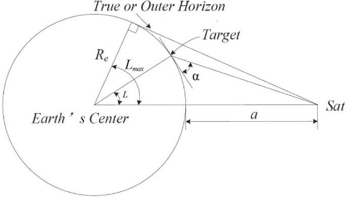
2.3 Number of Satellites Required
Satellite constellations are designed based on the requirements of the various areas of the earth needed to cover their global or regional satellite and in these areas, it is possible to assess the quality of satellite services for users. Figure 1 shows how much a satellite covers the area of the earth. \( \varphi \) and α, respectively, represent the line sight angle and the elevation observation angle. Only when the elevation angle is greater than α, users can connect to satellites and use their services. r and L, respectively, represent the radius of coverage by satellite and geocentric angle. According to Fig. 1, \( r , L\;{\text{and}}\;\varphi \) can be obtained through the following equations:

How to cover the earth by a satellite
The three factors, including satellite altitude, the lowest observation elevation angle \( \alpha_{\hbox{min} } \) and the largest central angle of the earth \( L_{\hbox{max} } \), are the most influential parameters on the satellite coverage of the Earth. When the observation elevation angle is increased, the range of ground coverage decreases, so we need more satellites to further coverage. Also, when \( \alpha_{\hbox{min} } \) is achieved, due to the decrease in height, satellite coverage of the Earth reaches the surface of the plateau and for full regional coverage, we need additional orbital planes and n satellite numbers. Due to various obstacles, including natural obstacles such as high mountains, which reduce observation, the lowest observation elevation angle can be obtained using an observation ground station [10]. To remove the barriers of satellite communications and meeting the needs of users, guidance and navigation from LEO and Polar orbits are used to design satellite constellations. To optimize the parameters of satellites and their selection, the parameters of the LEO and polar constellation indicators are examined and evaluated. Different methods are used to overlap the earthly footprints of satellites on the pole and increase coverage in low, middle and high latitudes [10]. Figure 2 shows the central angle of the Earth, also if we assume that n satellites are distributed at each orbital plane, so the angle between the two satellites is equal to S = 360°/N.
Two-dimensional image of the central angle of the earth
If \( 2L_{\hbox{max} } < S < 3L_{\hbox{max} } \), there is a swath of width \( L_{\text{sat}} \) covering continuously on the ground trace in real time. As shown in Figs. 3 and 4, it is assumed that the satellite footprint strip is projected on a hypothetical ground, as well as when \( 2L_{\hbox{max} } < S < 3L_{\hbox{max} } \) the earth is considered non-rotating. Given these assumptions, the Earth’s rotation and its coverage gaps should be taken into account which these factors make the calculation time longer. If the constellation of the satellites uniformly and permanently covers the non-rotating earth, it can also cover the ground in real-rotating mode [11]. The width of coverage swath is given by,

The coverage of three adjacent satellites on the different orbit planes (2Lmax < S < 3Lmax)

The coverage belt of three neighbor Satellites on different orbits
Suppose satellites are on the neighboring orbit planes which are adjacent simultaneously moving in one direction, width or breadth of coverage of satellites is continuous and permanent is \( D_{{\hbox{max} \,{\text{S}}}} \), but if satellites are on the neighboring orbit planes which are adjacent simultaneously moving in contrary directions, \( D_{{\hbox{max} \,{\text{OPP}}}} \) denotes the width of the area covered continuously,
In Fig. 5, it is shown that half the number of satellites in constellations at any time move to the South Pole and the other half are moving towards the North Pole. Equation (10) is satisfied with both coverage areas, while (11) denotes the satellites moving oppositely along the seams between them. Using Eq. (12), the whole coverage of the earth can be permanently realized by applying n satellites,

Polar constellation performance pattern (observed from the north)
Due to the effects of altitude, there are no change continuity in the polar constellation. Because the altitudes of the orbits are not considered, and considering the width of the coverage strip, the number of satellites is determined.
3 Satellite Design
Due to the fact that the purpose of this design is the optimal use of the LEO orbit for satellites, the technical specifications of the satellite required to be used in the orbit should be designed and carried out. This section is complementary to the design of satellite constellations. The satellites in LEO constellation are interconnected to the ground-based infrastructure and to the (PSTN) public-switched telephone network. The procedure of designing a triplet constellation with three adjacent satellites on different orbits is shown in Fig. 6. The discipline model of conceptual design is shown in Table 1. In this section, a system design is described to obtain the required satellite parameters for use in the LEO orbit. The genetic algorithm will use the necessary satellite design factors, the most important of which is the satellite mass and its launch cost. This research is a compilation of the system design and GA method.

Satellite design diagram relationships
3.1 Mission Design
Circuit parameters, speed variation rates, angles of the sun, and the amount of time available include mathematical calculations for design. Also, calculations include other restrictions and capabilities of launch vehicles. For simplicity of computing, we consider the Earth to be full Korean. All disorders and disturbances of the orbital are calculated under the worst conditions and are constant throughout the mission. All calculations are based on equations in Wertz and Larson [12]. The approximate height of the satellite vehicle is 429 cm which has a triangular cross section is equal to 89 cm per side. To optimize the use of the launch vehicle, a triangular configuration is used to launch several SVs simultaneously. It is maintained with three axes of stability of the SV kept long axially in space and in the direction of the center of the earth. Table 2 shows the spacecraft’s budget.
3.2 Payload
The satellite payload consists of an imaging payload (panchromatic camera). The panchromatic imager (PAN) mass and resolution are estimated in the scaling equations given by Wertz & Larson [12]. The resolution of payload and swath are considered in designing variables with lower and upper limits. The complexity of SV payload is determined to optimize to reduce the processing load on ground stations, as well as to provide better service and greater flexibility to conduct reaction routing traffic.
3.3 Structure and Mechanisms
The model of structural subsystem determines structure masses, mechanism masses and satellite bus dimensions. According to the launch vehicle axial, longitudinal loads and selected shape of the satellite bus, proper thickness of main structure of top and down decks, panels and intermediate ring with adaptor are calculated. Structure masses are computed on material density and thicknesses which are obtained from the reference model. Assuming that the mass is uniformly distributed system will calculate the inertia moment.
3.4 Subsystem of Command and Data Processing
The data storage capacity, temperature control and power consumption, hardware recording and mass processing of onboard are determined by the subsystem of command and data processing. Here, the component is selected relative to the required amount and data storage capacity. A complex classification is higher than the threshold of data, so it needs more mass and power. A hardware recorder fits the amount of data storage and thresholds required. There is also a simple classification when it is below the threshold of data, a simple model that requires less power and mass. All calculations for this discipline are based on Wertz and Larson [12].
3.5 Communication
Using the telemetry transmission and command (TT&C) data, sharing, storing, receiving, processing, and executing data collection can provide the desired performance for communication. These factors are all under the TT&C system or telemetry, tracking and controlling. The function of the TT&C subsystem is the simultaneous operation of the communication, which means that there is no weakening or interference in other missions. The communication subsystem determines specific components of communications (e.g., antennas, filters, diplexers, transmitters, etc.). Power consumptions and pointing requirements are also based on equations given by Wertz and Larson [12]. Simplified assumptions include the high-gain antenna in both communication and telemetry to the earth stations.
When satellite service is used as a network node for the entire communications network, the 29.1–29.3 GHz band for telecommand uplink is used. And the band 19.4–19.6 GHz is used to downlink telemetry. For relay between satellites, band 20–30 GHz is used where the TT&C data are shared. All control signals and TT&C data will be sent at speeds of 1.0 kbps when the narrow band transmission is in operation. To reduce the negative effects of geometry and antenna pattern to the lowest level, we use (BPSK/PM) binary phase-shift keying/pulse modulation. Table 3 shows the downlink telemetry properties. Transmission of the command received from the ground station is converted into a digital bit stream. When a command from the TT&C ground station is received by the destination satellite, if successful, the command is confirmed and executed at the specified time. Table 4 shows some command properties in the uplink.
3.6 Attitude Determination and Control
This subsystem model determines altitude components (e.g., horizon sensors, sun sensors, magnetic sensors, etc.), while altitude control actuators include maneuvers (e.g., magnetorquers, reaction wheels, gravity gradient boom, etc.), and mass is considered in the mission requirements.
The model also determines power requirements and satellite pointing capabilities. Orbit and attitude control system (OACS) are tasked to keep the satellite at the desired point and maintain its stability. It also has the ability to move and propel to satellite orbital transfer operations. The control of the initial attitude of the satellite is accomplished by a gyroscope stabilizer. The single-axis pitch is stable and fixed using the momentary force of the reaction wheel (MFRW). Using a small horizontal sensor set, the initial nadir attitude is calculated. It also uses infrared sensors to detect the Earth’s horizon; the value of roll and pitch errors is obtained. Pitch axis errors are removed by computing changes in wheel speed, which results in an exchange of the momentum. Both roll and yaw errors are taken by command torques from two magnetic torque rods. The direction of the Earth magnetic field is determined by a three-axis magnetometer. Momentum dumping of the MFRW is also accomplished using magnetic torque. In the various phases of the satellite operation, the OACS system uses additional sensors and hardware. After separating the boosters, a three-axis gyroscope set is used to detect and determine the initial attitude.
3.7 Electrical Power Supply
This subsystem determines the specific parameters of energy and power supply. Power, solar arrays, battery capacity, charger, and distributor are determined by this system. Normally, the solar array dimension growth is more than the allowable space of launch vehicle; deployable solar array option is chosen automatically. In this case, the solar arrays are assumed to be body mounted. All calculations are referenced by Wertz and Larson [12]. The bus control software runs inside the space vehicle computer (SVC), which controls battery recharging. Table 5 sets forth the electrical power budget and indicates end-of-life (EOL) power capabilities.
3.8 Heat and Temperature Control Subsystem
This subsystem controls the temperature of the metal parts, radiators, heater and power supply. The face of each side of the satellite and the thermal radiation are calculated, to comply with the instructions of the subsystem of temperature control and the temperature balance of the satellite. For reliability at maximum temperature, the radiator size is designed for the worst conditions, as well as heaters and fan heaters for the worst possible temperature and minimum temperature. So according to these assumptions and reliability in the design of radiators, heaters and so on, the temperature of satellite is controlled in a specific case of extreme intervals on the orbit. By incorporating active and passive controls, an optimal thermal environment is provided for the SV equipment, which is called the TCS subsystem or thermal control system. Pipes and heaters are used for heat transfer, which means the active heat control system. Thermal coatings, surface coatings, paints and radiators are used for passive thermal control. When the batteries are recharged, heat is produced, to reduce and discharge this heat from a set of radiator batteries. The bus control software runs inside the SVC, which controls battery recharging.
4 Requirements and Design Indicators
The LEO constellation is a combination of uniform orbital surfaces and apart from each other there is same number of satellites in orbit. For triplet LEO constellation design with three adjacent satellites, important parameters are needed for optimization which include inclination angle (i), satellite’s altitude (h), relative phasing (F), number of orbit planes (P) and total number of satellites (T) [4, 5].
According to regional coverage theory, determined by the inclination angle the regions covered with a circular area [4] in Fig. 7 are shown. If the inner radius of the cover is smaller, the extension of the coverage area is much higher. Figure 7 shows the coverage in two regions with two different radii, which are marked with two red and white colors. This radius is the function of the angle of inclination satellites (the central area of the circle is covered). Also, the inclination angle (i) should be equal to or greater than 3°, since the inclination angle (i) determines the outer radius of the cover circle. Because computational methods and techniques of global coverage based on the circular area of coverage are not available, in this paper, the numerical computation method has been selected which is done on the whole target grid [13]. Observation factors of a given grid in area and time with component j and k are given by,
where k and j, each one is in the order expressive to be the target grid in time scope and the area scope; factor \( Y_{\text{sur}} \) to calculate and evaluate the performance of a global satellite communications system which is based on regional coverage. It works by a constellation defined as below:
where \( Y_{{{\text{o}}\;{\text{total}}}} \) is the parameter to observe each target in the area of the desired grid and mission area. Also, m is the number of multi-layer regional coverage in the target grid area and Tc is the period of motion and return of satellites in the constellation. To optimize launch and production costs, we need to minimize the number of orbital surfaces in the triplet LEO constellation. Also, the constellation and satellite height should be at the lowest level for better performance and as the angle of gravity is low, the area of the circular cover is increased [3],

The radius of coverage based on regional coverage
So the parameters such as the cost of energy, production and launch are defined as follows:
where \( P_{0 } \) and \( h_{0} \) are, respectively, representing the number of orbit planes and the lowest satellite altitude. To specify the configuration of the LEO constellation, three special parameters T, P and F are required. If the time period is identical, satellites are in a similar geographical length and latitude, causing a collision between the satellites. This is due to the lack of precise configuration in the design of the constellation [14, 15]. For the costing reasons, It has been chosen for the lowest number Nmin and highest number Nmax to the number of area regional coverage satellites. According to the analysis of the issues mentioned, optimization design based on multi-threaded method for regional coverage LEO constellation is expressed as follows:
where \( Col \) indicates the collision of satellites in constellations with parameters T, P and F and also S represents the search area. LEO constellation has symmetric patterns and consists of (P), which represents the number of LEO orbit planes and (S) representing the number of satellites in each orbital plane that are placed uniformly and (T) representing the total number of satellites. Also, the inclination of each orbital plane with (i) is expressed. So in the LEO triplet constellation, the number of (P) orbits should be uniformly distributed at angle 360°/P and in each orbital plane, the angle between two adjacent satellites is equal to 360°/S.
5 Genetic Algorithm for Triplet LEO Constellation Design
Genetic algorithm (GA) is an optimization method based on Darwin’s natural and genetic selection. These algorithms are different from the traditional optimization techniques because they work with parser encoding instead of their parameters. This encoding is usually performed as a binary string, as was done in this study. The genetic algorithm optimizes and speeds up computation and accuracy of problem solving. This method has been used in several researches by Matthew L. Marcus, Daniele Mortari and William J. Mason, etc., and optimizes the design of the orbit. Further details of these researches can be found in references [20,21,22]. One of the most practical ways to solve multi-threaded issues is genetic algorithm method [16]. To design a LEO constellation with genetic algorithm, each of the design parameters is expressed in terms of the structure of a particular chromosome. Based on several individuals, the population size in this algorithm is determined that each individual is marked by an appropriate value, so that they meet the design requirements. As well as those responsible for additional requirements a value is assigned at a higher proportion. Therefore, the objective function must be defined on the basis of a proportional and consistent function, and also the objective function must also be determined to guide and control the evolutionary process. Utilizing Eq. (25), taking into account the weight of different goals and their choices, the consistent and fit function is defined as follows:
In the equations mentioned, u expresses the chromosome; w1, w2, w3 and w4 determine the weights of different targets in the algorithm. The number of satellites in orbital planes and the possibility of collision between the satellites of the LEO constellation are important conditions and the main design constraints. The possibility of a collision between satellites in the LEO constellation is extremely dangerous and irreversible, and this should be seriously prevented. This should be done while the number of satellites in the orbital planes significantly increases which increases cost and performance, but it must be tolerated as optimal. This paper presents a method for managing constraints and solving their problems and sorting requirements, and designing regulations and solving them will save significant amounts of time spent on computing. This method of managing constraints eliminates the unnecessary functions of the relative phase, and doing this by holding additional satellites and preventing their entry into orbital planes provides constellation requirements and prevents collisions of satellites. Also, this technique divides the probability of collisions of constellations and the probability of collisions of satellites into two sets and at two different levels. With this approach, all inescapable ways in both sets, which include high risk and low percentage risk, all in a collection, are classified and managed.
In the proposed genetic algorithm to provide diverse populations, we use boundary layer matches, or binary matches. Using the binary method, these parameters are selected, which are described in the simulation section. Using the constraint management method, we select the first binary set of chromosomes and from the two chromosomes selected if both solutions are applicable in the next step their fit compatibility will be compared and will be preserved at more important classification levels. The total number of satellites is equal to the number of satellites in each orbital plane multiplied by the total number of orbital planes used. Also, the type of chromosome selection and their dependence on the number of parameters are shown in Fig. 8. So, for the design of the LEO combination constellation, optimized parameters are obtained which, in the form of chromosomal shapes, form a genetic algorithm which can be defined as follows:

Chromosome structure of Constellation
In Eq (32), \( Num \) represents the number of satellites in each orbital plane used for each chromosome. In Fig. 9, the level “No collision of satellites at the intersection” after the optimal binary formation is done; since we have two distinct sets, collisions and intersections are not created and “change approach” expresses the mutation and changes in genetic properties. Figure 9 shows flowchart steps proposed using genetic algorithms to obtain optimal parameters for solving the triplet LEO constellation design problem. Re and m values are constant, but repeated in each loop. In previous papers, the design of the genetic algorithm with the main parameters of the LEO constellation has not been performed. Also, the number of parameter weights is low, which reduces the accuracy of algorithm calculations. In the new algorithm designed in this paper, the main parameters of the orbital and LEO constellations and polar constellations are considered. Also, using the mathematical expansion in the new algorithm for the number of chromosomes selected in each gene, we can prevent the collision of satellites and by generalizing the selected genes that are derived from the orbital parameters and cost, we cover the total area of the region based on the regional coverage. The goal is to optimize navigation and continuous coverage in low-altitude orbit to reduce the delay of sending and receiving data, and reduce the cost and number of satellites used by population size parameters in the GA processing. The population size is 840 chromosomes. In the two-point method, the children are crossover, with 12 arrays and 4200 generations needed. The fit function is also used to optimize the selection of both parent and child members. The second child inherits 80% of the genes of the parent. Also, parents are always based on the fitness function replaced. Crossover rate is 75% and Mutation rate is 0.98%. In mutant operation, using a uniform distribution of a chromosome is randomly selected and its value will change. Examples of chromosome production patterns and their results are shown in Fig. 10.

Optimal constellation design process using Genetic Algorithm

Chromosome production patterns and their results
Advantages of new Genetic Algorithm in this article:
-
Full regional coverage.
-
Multi-fold increase of coverage in the equator areas.
-
Full coverage of polar regions.
-
Multi-fold increase of polar region coverage.
-
Decrease of revisit time in polar and equator regions.
-
Lack of satellites collide in triplet constellation.
-
Increased reliability of performance and reduce the cost of launch and system.
6 Walker Constellation Design
Classical constellations Walker constellation coverages have interesting features and parameters. Homogeneous satellites are used to make the pattern of periodic and dynamic coverage tidy and accurate which is uniformly distributed in orbit. Also due to the same orbital tendency throughout the LEO triplet constellations, full stability and stagnation for each satellite and semimajor axis, the presence of disturbances and disorders has little effect and the geometric stability of the LEO triplet constellations pattern is continually maintained.
The features of an excellent global coverage are this triplet LEO constellation has three adjacent satellites as good candidates. Distributed on an orbital planes uniformly and regularly all satellites, we need five major parameters to determine a triplet LEO constellation,
The number of satellites used in each orbital planes is determined from the following formula:
The \( S({\text{range}}\;{\text{from}}\;0\;{\text{to}}\;T - 1) \) represents the satellite in a pattern triplet LEO constellation and U represents a unit of the pattern. Also, the \( \varOmega_{\text{s}} \) and \( \alpha_{\text{s}} \), respectively, represent the RAAN of satellite and latitude geometry arguments,
The important thing is where (S/M) denotes the integer division. Previous research has used sophisticated models that have high efficiency, but with non-uniform distribution and non-uniform coverage [17, 18]. We can resort it to improve the coverage.
7 Simulation
7.1 Triplet LEO Constellations Applying GA
The maximum and minimum angles of inclination used in the simulation are, respectively, 10° and 85°, and \( 2 \le P \le 5 \) and \( 3 \le Num \le 8 \). Traversal of the possible height range for the deployment of satellites is only between 700 and 1500 km. With 50 km steps to prevent the effect of dragging atmosphere in space and as well as the safety of the satellites from the effect of Van Allen belt radiation [19]. In a range of 40°–100° and 2° steps all orbital inclinations can be realized. When in different sets of inclination and altitude precession rate is reviewed and evaluated, three categories of values have been selected with different RAAN and arguments as: (1) the inclination is 58° and its altitude is 1450 km, (2) the inclination is 58° and its altitude is 1450 km and (3) the inclination is 85° and its altitude is 1450 km but with different RAAN and arguments.
Altitudes are in quasi retrograde orbit and they also meet the precession constraint condition. Minimum and maximum population sizes, respectively, are 40 and 105 races, and the probability of “mutation” and “crossover” is, respectively, in sets of 0.2 and 0.8. While w1, w2, w3, w4 are 0.5, 0.3, 0.2, 0.1, respectively,. w1, w2, w3 and w4 are the weights of different topics which according to the population size results are obtained, in the steps of the genetic algorithm which are retrieved and reproduced by the value of the fitness function. Using the constraint management technique and the selection of chromosomes by binary method in the proposed genetic algorithm to obtain an optimized design of triplet LEO constellations. Given the users need and demand, the number of satellites required and elevation angle are determined. So let us assume that the initial elevation angle is 5°, there are three constellations named by constellation 1, constellation 2 and constellation 3. Tables 6, 7 and 8 show the results of the simulation parameters for optimal design of the LEO triplet constellation with different RAAN and arguments. The coverage of triplet LEO satellite constellations are shown in Fig. 11. CONSTELLATIONS 1 and 2 have a coverage power equal threefold or more and in some areas of the earth they have a coverage power equal fourfold. Nevertheless, Antarctica and the North Pole area are not covered. Polar constellations cannot fully cover areas near the equator, since CONSTELLATION 3 has the power of covering twofold on half of the earth and in some other areas, its coverage is three- or onefold. But in the Antarctic and northern regions, the power of coverage of CONSTELLATION 3 is fourfold, as shown in Fig. 11.

Coverage of triplet LEO satellite constellation
The altitude and inclination angle are optimized with respect to precessional rate and argument and RAAN. Figure 12 shows variations and proportions of orbital precessional rate, and inclination angle and orbital altitudes to select the optimum set of parameters.

Orbital precessional rate vs inclination angle and orbital altitudes to select the optimum set of parameters
Inclination angles are chosen based on more coverage at different altitudes, which means that in the genetic algorithm, the best angle of inclination for each orbital height is chosen to provide better coverage. Also, the number of orbital planes in the genetic algorithm cycle is chosen so that the cover belt (cover street) is completely formed. Triplet LEO constellation with three adjacent satellites can cover stably and permanently the entire earth. In Fig. 13, based on the height function for circular orbits, the number of satellites required is shown. The number of satellites required depends on the overlapping coverage, constellation configuration settings and the size of the area around the nadir satellite coverage in which areas of complete regional coverage are not created. Disorder of the coverage is due to poor resolution and low radial target velocity. When we use a smaller number of satellites, the areas to be covered are in a latitude zone. It is also shown in Fig. 13 the regional coverage of the horizon range dependence and function of satellite elevation; it means that as the satellite’s elevation increases, the regional coverage of the horizon rises.

Height of satellites versus the number of satellites required to cover the entire earth and horizon range
In Fig. 13, the overall result is expressed for different altitudes, but the altitude required for the LEO triple constellation is 700–1500 km. This means that the number of satellites used is reduced. In contrast, they can use other satellites to cover a small area at a lower altitude, but this is not a global cover and only a non-uniformly regional coverage. Because at a lower altitude the speed of the satellites is higher, there is less time for Earth observation. Then there is less time to process and the resolution is weaker.
7.2 Triplet LEO Constellation Walker Consists of Polar Constellations Applying GA
CONSTELLATION 1, CONSTELLATION 2 (LEO Constellation) and CONSTELLATION 3 (Polar Constellation) are formed and combined as a triplet LEO constellation with GA. After examining and analyzing the covering power the triplet LEO constellation, the optimal area around equator is selected as the initial point of complete coverage. Figure 14 shows the coverage power of triplet LEO constellation. Figure 15 shows the global coverage performance of triplet LEO constellations in longitude. The fivefold provides global coverage for communication, as most areas are fivefold covered; some areas such as China and Russia have a power coverage of five- to sixfolds which greatly improves navigational capabilities. However, the power coverage in equator areas is threefolds.

The coverage of triplet LEO constellation

The coverage of triplet LEO constellation in longitude
Table 9 show the results of triplet LEO constellation for global coverage in longitude before using GA and after using GA. The result also shows that it provides coverage for the whole earth with the most optimal cost. Also, the time required for calculations is less than 1 day. Table 10 shows the results of regional coverage samples in Russian and Chinese regions. Figure 16 shows comparison of different coverages implemented using and without using proposed genetic algorithm. Table 9 shows the strength of global coverage in longitude from the equator to the South Pole and the North.

Comparison of regional coverage in different constellations given the effect of the GA in design
According to the simulation results and its use in orbital determination and revisit time, the diference in simulation results for revisit time, the expression is that the triple constellation designed with GA is optimal. Figure 17 also shows the simulation results of the LEO triplet constellation revisit time. Considering the effects of the proposed model of the GA and the triplet constellation method, the revisit time is reduced, which improves the quality of navigation performance.

Comparison for triplet LEO constellation
To achieve continuous and belt coverage of triplet LEO constellations, we can design and use three or more satellites adjacent to one orbit. But the optimal design takes place when adjacent satellites on an orbit do not overlap in the coverage of the area. For this reason, we can obtain the optimal coverage with the least number of satellites according to specifications \( \alpha_{\text{s}} \) and \( \varOmega_{\text{s}} \) for each satellite. The optimized mode has minimum overlap, and the minimum gap between two satellites. Figure 18 shows the variation in overlapping error rate of adjacent satellites. The curves shows that performance of three adjacent satellites that provide the most optimal coverage for triplet LEO constellations. Each of the adjacent satellites on the orbit has different \( \alpha_{\text{s}} \) and Ωs, as shown in Tables 6, 7 and 8.

Comparison of regional coverage in different constellations
Due to the latency time of sending and receiving data in satellite communications, in the constellation design, we should use more satellites to reduce the amount of communication time. In triplet LEO constellation designed, the amount of communication time through three adjacent satellites has been minimized. Figure 19 shows the curves of delay time in triplet constellation of GEO and LEO.

Variation curve of the delay time for the triplet constellation in the GEO and LEO orbit based on availability
Figure 20 shows the optimization results of cost reduction using proposed genetic algorithm in the simulation of triplet constellations. Cost is a function of the number of launched satellites. The curve of hybrid constellations shows that triplet constellation has optimum coverage with optimal costs and in more efficient and economical way.

Cost effects of using the genetic algorithm
8 Conclusion
A triplet LEO constellation with three adjacent satellites in orbit comes with three satellites adjacent in each orbit with GA for enhancing communication and strengthening navigation as proposed in this paper. It takes an integrative consideration of various kinds of factors in each stage of process, effective elements at each step of the project, such as global land cover, costs and reliability of launch and control, fuel and energy costs, collisions or failures of satellites, creating a very smart and strong telecommunication network using complex and complex transactions which lead to the design of a triplet LEO constellation system. In the analysis, many factors are considered, including complexity, payload, LEO orbital height, number of satellites, etc., to factors such as user and customer satisfaction, and optimal sound quality, etc. Since the beginning of the project, it has been stressed that the transactions of engineering systems for telecommunication formalities are to be observed in the LEO triplet constellation architecture. Multi-purpose optimization design based on the region in the constellation of regional bills with three satellites adjacent in each orbit is considered. A functional genetic algorithm is presented which is obtained under the influence of constraint controls. This is an applied genetic algorithm for finding optimized solutions, in which the altitudes and inclinations, functions of triplet LEO constellations with three satellites adjacent and precession have been taken into consideration. With proposed GA, the compatibility and interoperability between normal constellations and triplet LEO constellations can be improved. GA can be also used in MEO constellations and it can be generalized to other constellation design issues in terms of reliability and cost, such as GPS constellations and iridium, etc.
References
Liu G (2003) Research on the key technologies of networking in the NGSO satellite mobile communication system. University of Electronic Science and Technology of China, Chengdu, p 12
Curry GR (1996) A low-cost space-based radar system concept. Sept, IEEE AES Magaz, pp 21–24
Whelan DA, Filip A, Koss JJ et al (2000) Global space-based ground surveillance mission utility and performance of Discoverer II. IEEE aerospace conference proceedings pp 1–I1
Tollefson MV, Preiss BK (1998) Space based radar constellation optimization. IEEE aerospace conference, pp 379–388
Budianto LA, Olds JR (2000) A collaborative optimization approach to design and deployment of a space based infrared system constellation.In: IEEE NAECON, pp 385–393
Li SD, Zhu J, Li GX (2005) Optimization of LEO regional communication satellite constellation with GA algorithm. J Commun 26:122–128
Circi C, Ortore E, Bunkheila F (2014) Satellite constellations in sliding ground track orbits. Aerosp Sci Technol 39(8):395–402
Bai HF, Ren X, Xi XN (1999) The orbit models for designing LEO satellite constellations. J Natl Univ Defense Technol 21:1–4
Lee S, Wu Y, Mortari D (2015) Satellite constellation design for telecommunication in Antarctica. Int J Satell Commun Netw. https://doi.org/10.1002/sat.1128
Wertz JR (2009) Orbit & constellation design & management. Hawthorne, ch 9 and ch 13. Microcosm, Springer Press, New York
Liu SK, Liu HD (2014) Constellation design and performance simulation of LEO satellite communication system. GNSS World China 39:19–23
Wertz JR, Larson JR (1999) Space mission analysis and design, 3rd edn. Microcosm, Torrance
Galati G (1996) Spaced-based SSR constellation for global air traffic control. In: IEEE, Trans. AES-32, no. 3, p1088 1106
Frayssinhes E, Espace A (1996) Investigating new satellite constellation geometries with genetic algorithms. In: AIAA-96-3636-CP
Biria AD, Marchand BG (2014) Constellation design for space-based space situational awareness applications: an analytical approach. J Spacecr Rockets. https://doi.org/10.2514/1.a32622
Fakoor Mahdi, Bakhtiari Majid, Soleymani Mahshid (2016) Optimal design of the satellite constellation arrangement reconfiguration process. Adv Space Res 58(3):372–386
Lansard E, Frayssinhes E, Palmade JL (1996) Global design of satellite constellations: a multi-criteria performance comparison of classical walker patterns and new design patterns. IAF-96 A.1.02, 47th international astronautical congress. Beijing (7–11 Oct. 1996)
Dufour F, Lasserre E, Brousse P (1999) A multistage approach to design and optimize a communication satellite constellation. In: IAF-99-A.2.09, 50th international astronautical congress. Amsterdam (4–8 Oct. 1999)
Chen R (2004) Design and Analysis of non-geostationary orbit communication system. Modem science technology of telecommunications. J Electron Inf Technol 2004(1):40–44 (in chinese)
Mason W, Coverstone-Carroll V, Hartmann J (1998) Optimal earth orbiting satellite constellations via a Pareto Genetic Algorithm. In: AIAA/AAS astrodynamics specialist conference and exhibit. https://doi.org/10.2514/6.1998-4381
Orbit Design for Ground Surveillance Using Genetic Algorithms (2006) Ossama Omarabdelkhalik, Daniele Mortari. Journal of Guidance, Control, and Dynamics 29:1231–1235. https://doi.org/10.2514/1.16722
Marcus ML, Sedwick RJ (2017) Low earth orbit Debris removal technology assessment using genetic algorithms. J Spacecr Rockets 54:1110–1126. https://doi.org/10.2514/1.a33671
Author information
Authors and Affiliations
Corresponding author
Additional information
Publisher's Note
Springer Nature remains neutral with regard to jurisdictional claims in published maps and institutional affiliations.
Rights and permissions
About this article

Cite this article
Kohani, S., Zong, P. A Genetic Algorithm for Designing Triplet LEO Satellite Constellation with Three Adjacent Satellites. Int. J. Aeronaut. Space Sci. 20, 537–552 (2019). https://doi.org/10.1007/s42405-019-00149-6
Received:
Revised:
Accepted:
Published:
Issue Date:
DOI: https://doi.org/10.1007/s42405-019-00149-6