
Abstract
Dongodien (GaJi4) is a sequence of sub-lacustrine, beach, and sub-aerial lake margin sediments of the Galana Boi Formation at Koobi Fora, Lake Turkana, Kenya. The sediments accumulated under a climate of increasing aridity in the latter African Humid Period. The section contains two archaeologically rich beds (Horizons B and A). Here, we present new optically stimulated luminescence (OSL) dates that are independently corroborated with C-14. The lower bed (Horizon B) has an OSL age of 4.14 ± 0.27 ka, supported by C-14 ages of 4.71 ± 0.13, 4.79 ± 0.08, and 4.70 ± 0.06 ka cal BP. The upper bed (Horizon A) has an OSL age of 2.34 ± 0.20 ka, consistent with that of site stratigraphy. In contrast to luminescence dating attempts elsewhere in the East African Rift System, quartz-OSL from this locality and sites FwJj5 and FwJj25 ~40 km NW has a dominant fast component and robust intrinsic characteristics. OSL confirms Dongodien recorded the first known appearance of pastoralism in East Africa; it lays within a tsetse-free corridor between northern and southern Africa. Interpretation of archaeologically rich horizons as beach deposits is consistent with published lake level curves and Holocene highstands. Archaeological material (obsidian microliths, Nderit pottery, wild and domestic mammal bones, fish bones) suggests mixtures of subsistence strategies (hunting-gathering, fishing, herding) as the climate became more arid. The site may have been chosen for reoccupation because of abundant fish associated with lacustrine upwelling near Koobi Fora, a cuspate foreland.
Résumé
Le site de Dongodien (GaJi4) correspond à une séquence de sédiments de la marge du lac classifiables comme étant sous-lacustre, de plage, et sous-éolien. Typiques de la formation Galana Boi à Koobi Fora, au lac Turkana, au Kenya, ces sédiments se sont accumulés dans un contexte d’aridité croissante lors de la dernière période humide africaine. La section contient deux niveaux archéologiquement riches (horizons B & A). Nous présentons ici de nouveaux âges OSL, indépendamment confirmés par datation C-14. Le niveau inférieur (horizon B) présente un âge OSL de 4,23 ± 0,27 ka. Un résultat étayé par le C-14 qui présente des âges de 4,71 ± 0,13, 4,79 ± 0,08, et 4,70 ± 0,06 ka cal BP. Le niveau supérieur (horizon A) présente un âge de 2,34 ± 0,20 ka cohérent avec la stratigraphie du site. À la différence des tentatives de datation par luminescence entreprises ailleurs dans le rift Est-Africain, les résultats obtenus via la méthode quartz-OSL pour cette localité ainsi que les sites FwJj5 et FwJj25 (~40 km nord-ouest) ont une composante rapide dominante et des caractéristiques intrinsèques robustes. La méthode OSL confirme la première apparition connue du pastoralisme en Afrique de l’Est au cours du site de Dongodien le long d’un corridor dépourvu de mouches tsé-tsé entre l’Afrique septentrionale et méridionale. L’interprétation de ces horizons archéologiquement riches comme les dépôts de plage est. cohérente avec les courbes de niveaux du lac publiées et les hauts peuplements de l’Holocène. Le matériel archéologique (obsidiennes, poteries Nderit, os de mammifères domestiques et sauvages, os de poissons) suggère une diversification des stratégies de subsistance (chasse et cueillette, pêche, pastoralisme) à mesure que le climat devient aride. Ce site a peut-être été réinvesti par les populations en raison des abondantes ressources ichtyennes associées à la remontée des eaux près de Koobi Fora.
Introduction
The Holocene was a time of dramatic climate change in Africa (de Menocal et al. 2000; Kropelin et al. 2008; Street and Grove 1979; Thompson et al. 2002). In the tropics, climate change was due to the fluctuating precipitation related to long-term, Milankovitch-controlled climate cycles and the response of vegetation to changing moisture budgets rather than temperature changes (Kutzbach et al. 1996; Ruddiman 2000). In East Africa, the shift went from wetter climate (the peak of the Holocene Humid Period), that was characterized by high lake levels in the early-mid-Holocene, to drier climate with lower lake levels in the late Holocene (de Menocal et al. 2000; Street-Perrott and Harrison 1983) (Fig. 1). Data from a marine core at 20°N revealed that change to aridity was abrupt, not gradual. It occurred when summer isolation, which drives the tropical monsoon system, increased above 470 W(watts)/m2 (de Menocal et al. 2000). This “tipping point” is ~4.2% above modern values. The level of large East African lakes, like Lake Turkana, lowered as the region headed into drought (<4500 BP), leaving successively younger shorelines stranded as beach, delta, and coastal dune sediments (Galana Boi Fm.).

Holocene humid period. Holocene climate is astronomically controlled by Milankovitch precession cycles (19–23 ka) (Hilgen 1991). In Africa, the solar input to the Earth surface (W/m2) that steadily increases and decreases insolation causes an increase in summer monsoon intensity which leads to higher annual rainfall (Kutzbach 1981). JJA is abbreviation for June, July, and August. The graph representing conditions 20°N is modified from de Menocal et al. (2000)
The paleoenvironmental framework of subsistence strategies and cultural change during the Holocene in East Africa has been the focus of numerous studies in the last three decades (Ambrose 1984; Barthelme 1981; Bower 1988; de Menocal 2001; Gifford-Gonzalez et al. 1999; Robbins 1974; Yellen and Harpending 1972). In northern Kenya, fishing was the dominant subsistence strategy at ~9000 BP. However, by ~4000 BP, the presence of domesticated stock indicates a shift in subsistence practices to pastoralism, but the exact timing and mode of that transition remain unclear (Barthelme 1985; Marshall 1990; Marshall and Hildebrand 2002; Ndiema et al. 2011). Several studies have noted the interrelationship and importance of climate and its impact on ecology, humans, and dietary resources (Coe et al. 1976; Ellis et al. 1987; Gifford-Gonzalez 1998; Marshall 1986). However, the chronological sequencing of these important cultural adaptions in areas has been difficult because of few carbonates for uranium-series dating and a paucity of organic-rich sediments in the sandy lake-margin deposits for radiocarbon dating. Thus, the cause-and-effect link between climatic conditions and type of subsistence practices remains elusive.
Recent excavations of sediments along the northernmost shoreline of Lake Turkana (4°N) yielded archaeological materials, high-resolution stratigraphy and paleoenvironmental analyses, quartz-OSL dates, and new insights into cultural changes (e.g., use of stone bowls) associated with the late Holocene drought (Ashley et al. 2011; Ndiema 2011; Ndiema et al. 2009). This study builds on that work and describes the geologic history, chronology, and paleoenvironmental framework of Dongodien (GaJi4), located ~50 km south of the Ethiopian border on the Koobi Fora cuspate foreland (Fig. 2). Previous age dating of Dongodien, which appears to be the earliest pastoral site in Kenya, produced a wide range of dates from mollusk shells (~10,320 ± 150 BP), fish bone (4580 ± 170 BP), and mammal bone (3405 ± 130 BP) to charcoal (4100 ± 125 BP; 3960 ± 60 BP; 3945 ± 135 BP) (Barthelme 1985; Owen et al. 1982). Thus, the site was targeted in this study for quartz-OSL dating, in order to verify the age, as part of a larger geoarchaeological investigation.

Regional location map. Map of Kenya shows topography (see color-coded legend) and lakes. The East African Rift system extends in a north–south lowland. Lake Turkana occupies the depression in the north. The location of the study and Fig. 4 are outlined by a square. Source is Wikimedia Commons
The archaeological material recovered from Dongodien excavations in 2008 and 2009 provides some new information to augment prior investigations by Barthelme 1981 and others (Gifford-Gonzalez 1998; Marshall et al. 1984). The goals of this paper are to (1) provide a paleoenvironmental reconstruction of the site in the context of Holocene climate change, and (2) refine the correlation of climatic conditions and types of subsistence strategies used in the region by obtaining luminescence ages of the archaeologically rich horizons.
Background
Geology
Lake Turkana is situated just north of the equator in the eastern branch of the East African Rift System (EARS) (Fig. 2). It is 290 km long and 32 km wide, and geological studies revealed the lake basin is composed of two half grabens (north and south basins) (Yuretich 1979). Dongodien is on the eastern shoreline of the north basin (Fig. 2). The bedrock is composed of pre-rift metamorphic basement rocks, as well as syn-rift volcanics (andesites and basalts) and thick volcaniclastic sedimentary sequences dating to the Miocene (Feibel 2011). The Holocene Galana Boi Formation (Owen 1981) unconformably overlies Plio-Pleistocene sediments (Koobi Fora Formation, ~0.6 Ma in age) and is distributed over a wide area (~2000 km2) fringing the lake. The Galana Boi Formation is composed of lacustrine (diatomaceous silts, stromatolites, and oyster bank bioherms) and marginal lacustrine (eolian, fluvial-deltaic, beach, fringing lagoon) deposits which accumulated during a series of Holocene climate-induced lake level fluctuations (Barthelme 1981; Frostick and Reid 1986; Owen et al. 1982; Owen and Renaut 1986). The deposits range in thickness from 50-m infilling topographic lows, such as pre-existing river valleys, to <10-m thick capping topographic highs. Sediments occur only to 80 m above modern lake level (~375 m above sea level), as +80 m is the low point on the basin margin and the elevation of a spillover to the north of Lake Turkana into the Nile drainage (Butzer et al. 1972; Garcin et al. 2012; Owen et al. 1982). Over the last four decades, there have been numerous studies of Turkana lake level fluctuations. Depending on where the studies were done and the type of data collected, at least five different curves have been published (Bloszies et al. 2015; Butzer 1980; Forman et al. 2014; Garcin et al. 2012; Owen et al. 1982). However, they all have similar variability: (1) consistently high lake levels during the early Holocene (12–8 ka), (2) fluctuating lake levels during the mid-Holocene (8–4 ka), and (3) a rapid drop to current lake levels during the late Holocene (4 ka–present). We have chosen two representative published curves to illustrate the Holocene lake level change (Garcin et al. 2012; Owen et al. 1982) (Fig. 3). Holocene sediments accumulated on the land surface as the lake level fluctuated and eventually lowered to modern levels.

Lake level history. Turkana lake level (elevation m) is graphed against time in thousands of years. The level of the overflow sill (~450 m) is indicated. Published graphs of Owen et al. (1982) and Garcin et al. (2012) are shown in dashed and dotted lines, respectively. Following the regional climate regime of the African Humid Period, the lake was mainly full to overflowing during the early Holocene. During middle to late Holocene, it fluctuated and lowered to its current level ~375 m. The location in time and space of the two Dongodien archaeological sites interpreted as beach deposits are indicated with stars
Dongodien is just one of many archaeologically rich areas located in the sandy shoreline deposits fringing the lake (Fig. 4).

Map of local archaeological sites. Map depicts the location of the archaeological sites on the shoreline of Lake Turkana first studied by John Barthelme (Barthelme 1981). Symbols distinguish the dominant subsistence interpreted for each site. Dongodien (GaJi4) is the most southerly site. Data compiled by L. Dibble
Climate and Hydrology
The weather is hot and dry. The temperatures range from 30 to 40 °C with the highest temperatures between October and January. Rainfall varies seasonally and is controlled by the migration of the Inter-Tropical Convergence Zone (ITCZ) (Nicholson 2000). The “long rains” occur March–May and the “short rains” October–November. Mean annual precipitation is ≤200 mm/a and evaporation is estimated at ~2300–2700 mm/a, thus the lake has a persistently negative hydrologic budget (Yuretich and Cerling 1983). But the mean annual rainfall is thought to vary on multi-decadal timescales driven by the coupled ocean and atmospheric system in the Indian Ocean (Tierney et al. 2013). Ultimately, water balance (precipitation minus evapotranspiration) in the Turkana watershed determines whether wet periods or droughts occur. Water balance impacts plant biomass and animal populations, surface runoff, availability of freshwater, lake levels, and lake chemistry (Yuretich and Cerling 1983). The main source (~90%) of water to Lake Turkana is surface discharge from the Omo River which drains the Ethiopian Highlands to the north. The lake also receives groundwater inflow sourced by rainfall on the uplift fault blocks at the basin margins (Fig. 2).
Holocene climate (i.e., wet-dry cycles) in the low latitudes is thought to be caused by astronomically controlled (Milankovitch) precession cycles (19–23 ka) (Hilgen 1991; Kutzbach and Street-Perrott 1985; Pokras and Mix 1987; Ruddiman 2000; Verschuren et al. 2000). Solar input to the Earth’s surface (W/m2) steadily increases and decreases on this timescale (Fig. 1). Increasing insolation causes an increase in summer monsoon intensity which leads to higher annual rainfall (Kutzbach 1981). More precipitation with no change in evaporation leads to wetter climate, which is manifested in more water on the surface (rivers and lakes) and sub-surface (groundwater reserves) (Street-Perrott and Harrison 1983; Street-Perrott and Roberts 1983). The Earth is currently near a solar input minimum and the tropics are now in the driest part of the cycle (Fig. 1).
Superimposed on this steady long-term, astronomically controlled climate fluctuation are shorter-term variations of increased and decreased rainfall that appear to be driven by episodic changes in ocean circulation in the Indian Ocean: the Indian Ocean Dipole (IOD). Operating seasonally, the IOD is caused by the difference in sea surface temperature (SST) between the eastern and western areas of the Indian Ocean. Rainfall increases on Africa under a positive IOD event, when SST rises in the western compared to eastern ocean, and moisture-laden winds move eastward (Marchant et al. 2006). Conversely, rainfall decreases under a negative IOD event, when SST falls in the western ocean and winds are from west to east. Tierney et al. (2013) have suggested that the IOD is a possible driver of multi-decade and longer climate variations, and paleo-IOD reconstructions from fossil corals from the eastern Indian Ocean suggest that IOD events may have varied in strength and timing under past climate conditions (Brown et al. 2009). In summary, there remains a major scale gap between known climate drivers of the thousands of years represented by Milankovitch cycles and the annual migration of the ITCZ that needs to be investigated.
Archaeology
The Holocene archaeological record of people living in the Lake Turkana basin has been studied for over 40 years (Ambrose 1998; Ammerman et al. 1978; Bower 1991; Gifford-Gonzalez 1985; Leakey 1935; Phillipson 1984). Some of the best documented Holocene archaeological material in East Africa comes from Central Kenya and the shores of Lake Turkana (Ambrose 1984, 1998; Barthelme 1981; Barut 1999; Gifford-Gonzalez et al. 1999; Phillipson 1977; Robbins 1972, 1974). A recent review paper summarizes the sociocultural responses (as evidenced by the archaeological records) to changing water levels of Turkana (Wright et al. 2015).
Systematic archaeological excavations were undertaken in deposits of Holocene age on the western side of the lake at Lothagam (Robbins 1974). Further excavations were conducted at Lowasera, a fishing settlement situated near the southeastern end of the lake (Phillipson 1977). In the late 1970s, a large-scale research investigation of Holocene archaeological sites was conducted by John Barthelme with the aim of studying hunter-gatherer subsistence strategies, settlement patterns, economies, and adaptations (Barthelme 1981, 1985). Barthelme surveyed and excavated in Galana Boi deposits, and his research yielded diverse archaeological, geological, and zooarchaeological data from 30 sites and 74 localities. The inventory of bones and lithic artifacts excavated at Dongodien in an earlier study is summarized in Table 1 (Barthelme 1981). Based on his field research and artifact analysis, he suggested that three distinct subsistence groups (hunter-gatherers, fishing folk, and pastoralists) lived in the area during the Holocene.
Barthelme proposed that the early sites for hunter-gatherer camps occurred when the lake level was high and the shoreline was near the basin’s perimeter. These would have been Later Stone Age (LSA) sites, a period in African prehistory roughly contemporaneous with the European Upper Paleolithic. Barthelme noted that these sites lack pottery and faunal remains, yet had a distinct stone tool industry composed mainly of chert microliths. As there is little or no direct evidence of food consumption at these sites, it has been difficult to characterize the diets of these people. In addition, these basin-margin localities did not yield datable materials so the chronology is speculative.
The most numerous archaeological sites found by Barthelme were the early to middle Holocene fishing camps, dating to about 9500 years ago, and correlated with a lake level of about +75–80 m above the arbitrarily chosen 1975 lake level (Owen et al. 1982) (Fig. 3). At about 6500 BP, lake levels began to recede and fluctuated around +55 m (Fig. 3). The analyses of archaeological material indicated a shift to a pastoralist subsistence strategy by ~4000 BP, suggested by the presence of domesticated fauna in direct association with a cross-hatched decorated ceramic tradition referred to as Nderit ware (Barthelme 1985; Marshall 1986, 1994).
Methods
Field
Geology
GaJi4 (Dongodien) is situated in the archaeological Area 102 at Koobi Fora on the northwestern shoreline of Lake Turkana at ~4°N (Fig. 4). Galana Boi sediments are exposed in a near-vertical 8-m bluff eroded into the margin of the Koobi Fora Ridge (Fig. 5a). There is a 2°–4° dip of some the beds to the south and southwest. This is likely to be a primary dip of the lake shoreline sediments deposited on a gently sloping lake margin. The site was located with Global Positioning System (N 3°55′45″; E 36°14′17″). A step trench was dug in 2006. The stratigraphy was logged, 25 samples were collected for textural analyses, and 2 samples (GB-16 and GB-17) were collected from homogenous sand in light-proof tins for luminescence dating (Fig. 5b). The exposures chosen for sampling have well-preserved bedding structures and no observable bioturbation. Care was taken to minimize exposure of the sediment to daylight while sampling. In 2008, a 1-m-wide step trench was excavated. Observations were made on sedimentary structures, mineralogy, fossil content, extent of pedogenesis, and presence of archaeological remains before the archaeological excavation took place.

Outcrop photo. a The 8-m high bluff eroded into the Koobi Fora Ridge prior to excavation. Locality of the geology step trench is outlined. b Step trench dug in 2006. Arrows mark the archaeological Horizons A and B and location of samples collected for OSL dating (photos: G. Ashley)
Archaeology
Charcoal samples were collected by John Kamau in 1991from a sub-circular concentration within Horizon B. His excavation notes are housed with the artifacts at the National Museums of Kenya (NMK) (Kamau 1991).
In 2008, based on Barthelme’s field notes, the original datum and coordinate system used by Barthelme during excavation was reconstructed (Barthelme 1981). A 20-m2 trench was excavated in Horizon B in December 2008 and January 2009. The 2008 trench was close to and essentially in the same 0.5-m thick stratigraphic horizon (B in Fig. 5b) as that published in Fig. 5 of Barthelme (1981). The recovered archaeological remains were concentrated in a 30-cm thick horizon within the 0.5-m thick bed with scattered artifacts both below and above this concentration (Ndiema 2011). All stone artifacts, bones, and potsherds were mapped into three-dimensional coordinates using a Topcon DT 209 digital laser theodolite. Sediments were sieved through a 4-mm sieve. All specimens were collected, labeled, and bagged. They are archived in the National Museums of Kenya collections. Table 1 has a complete inventory; a full report of the archaeology excavated from Horizon B is in Ndiema (2011). Data for Horizon A are not included in this paper.
Laboratory
Sediments
Sediments were analyzed for texture following standard procedures (Folk 1980). Bulk sediment was treated with hydrogen peroxide to remove any trace of organics and with dilute HCl to remove carbonate. The sediment was wet-sieved. Sand was dried and sieved with Ro-Tap; the grain size of the silt and clay in the slurry was analyzed by pipette. A binocular microscope was used to examine shape and mineralogy of grains, as well as presence and type of fossils.
Stable Isotope Analyses
Analyses of stable isotope (C and O) values of the shells were conducted using a Micromass Optima mass spectrometer at the Stable Isotope Laboratory in the Department of Earth and Planetary Sciences (Dr. James Wright, Laboratory Director). Values were reported in standard per mil (‰) notation relative to the Vienna Pee Dee Belemnite standard (V-PDB) through the analysis of an internal laboratory standard that is routinely measured with NBS-19 calcite. We use the reported values by Coplen et al. (1983) of 1.95 and −2.20‰ for δ13C and δ18O, respectively. The long-term standard deviations on the internal lab standard are 0.05 and 0.08‰ for δ13C and δ18O, respectively.
OSL Dating
Optically stimulated luminescence (OSL) dating of the sediment samples was performed at the Kansas State University luminescence laboratories. Both continuous wave OSL (CW-OSL; Fig. 6a inset) and linearly modulated OSL (LM-OSL; Fig. 6b) analyses were conducted on 175–212 μm quartz extracts, using aliquots 3 and 5 mm in diameter, respectively. Single-aliquot regenerative-dose (SAR) protocols (Fig. 6a), dose distribution analyses (Fig. 7), and statistical age models were used to determine final equivalent dose (D e). Total dose rate was determined from ICP-MS and ICP-OES analyses, field moisture assessment, and cosmic dose-rate calculations. Further details of OSL dating methods are documented in “Supplementary Material.”

a CW-OSL data showing typical SAR dose response and natural decay (inset) for sample GB-17; filled circles are recycled points. b Net natural LM-OSL data (gray open circles) for GB-17. Mathematical fitting indicates fast (F) and two slow (S1, S2) components; a medium component in the natural OSL could not be resolved using a SigmaPlot™ transformation, but was present in regenerative dose data for the same aliquot

OSL results. a GB-16 (Horizon A) equivalent dose data is best represented by a minimum age model (gray band). Radial plot is centered on the central age result. b GB-17 (Horizon B) equivalent dose result was calculated with a central age model
Results
Sedimentology
The sedimentary sequence at Dongodien is an 8-m thick, coarsening upward stratified unit (Fig. 8). The section was logged by Barthelme in the late 1970s and he interpreted it to be a depositional record under a high lake level, fluctuating levels, and then falling lake level (Barthelme 1981; Fig. 8). The sand percentage increases from 4 to 6% at the base to 100% between 4 and 7 m and decreases to 50% at the top. The oldest sediments (0–1.75 m) are compact, massive silt (80%) with diatoms and gastropods, such as Cleopatra bulinoides, Olivier. The overlying unit is a sandy silt with 55% sand and 35% silt; the contact between the two units has broken shells and a poorly developed paleosol. A ripple-bedded fine sand (50–60% sand) with scattered broken shell hash occurs at 3.5–4.0 m and a sharp erosive contact occurs at 4.0 m. The beds dip gently 2°–4° to the southwest and west. The sediments are fine to medium well-sorted sand, ripple bedded with abundant whole freshwater gastropods, such as Melanoides tuberculata. Above this unit is a 0.5-m thick bed (from 4.6–5.2 m) composed of medium-coarse sand which contains the archaeological Horizon B (Barthelme 1981). This bed has been dated with OSL and radiocarbon. A sharp erosive contact separates this coarse bed from a slightly finer grained (fine to medium ripple-bedded sand) from 5.2–5.8 m. This is overlain by medium to coarse sands (5.8–6.4 m) containing another archaeological unit (Horizon A) (Barthelme 1981) also dated with OSL. The coarse well-sorted sediments contain abraded bones and stone tools, fish bones, and broken mollusk shells. The uppermost unit (7.0–8.0 m) is sandy silt with vague bedding, root traces, broken shells, and scattered carbonate nodules.

Stratigraphic section and paleoenvironment. The 8-m high stratigraphic section is a coarsening up sequence reflecting high lake levels in early Holocene, fluctuating levels in mid-Holocene, and falling levels in late Holocene. Lake level change, sand percentage, and interpreted depositional environment are indicated along the side of the graph. Location of fossils and photo of the species used in stable isotope analyses are shown. The locations of the materials sampled for dating are shown
Stable isotope ratios of oxygen of ten lacustrine gastropods that were considered representative of those recovered from GaJi4 ranged from δ18O + 3.37 in the bottom of the section (~1 m) to δ18O + 0.77 at the top of the section (~7 m). These are similar to isotope ratios of the mollusk shells reported in Garcin et al. (2012) in which they created a depth-volume curve for Lake Turkana, a closed basin. They found a positive correlation between δ18O values of shells and the water depth (i.e., lake volume) at the time the mollusk was living. Their model suggests that lighter δ18O values are associated with higher lake levels (larger lake volumes) and heavier δ18O values are associated with lower water levels (smaller lake volumes).
Archaeology
Table 1 summarizes the archaeological material excavated by Barthelme (1981) and Ndiema (2011) in 2008–2009 from Horizon B, GaJi4. Based on NISP, domestic taxa comprise 53% of recovered bones, of which wild taxa comprise 42 and 5% of miscellaneous fossils, such as those of birds, turtles, and reptiles. The mammalian fauna are essentially all small Bovidae, category 2 (Gifford et al. 1980; Gifford-Gonzalez 1991). A total of 1123 lithic specimens were recovered, 76.5% of which exhibit modification either through use, trimming, or backing. In particular, obsidian artifacts show repeatedly reworking and reduction in the GaJi4 tool kit. Detailed artifact analyses are being published separately.
Chronology
Luminescence Dating
OSL characteristics of the samples from Dongodien are similar to those reported by Ashley et al. (2011) for samples from the FwJj5 and FwJj25 Galana Boi archaeological sites about 40 km to the north (Fig. 4). The CW-OSL data for the Dongodien samples suggest a dominant fast component in the natural OSL decay curve and indicate robust SAR characteristics with good recycling and low recuperation (Fig. 6a). The natural LM-OSL data confirm the presence of the fast component (Fig. 6b); the medium component was absent in deconvolution of the natural signal, but was observed in regenerative LM-OSL data. Similarly, results from dose recovery tests support SAR data: average measured-to-given ratios for variation in 10-s pre-heating from 180 to 280 °C (in 20 °C steps) for samples GB-17 and GB-16 are 0.98 ± 0.10 and 0.98 ± 0.03, respectively; individual measured-to-given ratios and corresponding pre-heat in parentheses chosen for replicated D e measurements are 1.01 ± 0.03 (240 °C) and 0.99 ± 0.04 (200 °C). In contrast to the absence of fast component and failure of dose recovery tests for CW-OSL for quartz from fluvial samples from the Narok and Enderit Rivers (Choi et al. 2006), quartz from Lake Turkana lacustrine beach environments from FwJj5 and FwJj25 (Ashley et al. 2011) and Dongodien (this study) have a dominant fast component and robust SAR characteristics (Fig. 6), and dose recovery tests support SAR data.
Radial plots of the distribution in D e values for each sample are shown in Fig. 7. GB-16 had a somewhat asymmetric distribution and relatively high overdispersion of 23% (Fig. 7a). The observation of undisturbed sediment (“Geology” section) suggests that a certain degree of partial bleaching is a more significant cause of scatter, than post-depositional mixing processes. This dataset was analyzed using a Minimum Age Model; the lowest D e value had very low significance and was not included in the analysis. In contrast, GB-17 is more symmetric with overdispersion indicative of more complete bleaching. The Central Age Model was used to calculate the weighted mean D e for this sample. Measured data, calculated dose rate, OSL ages, and radiocarbon data are shown in Tables 2 and 3. An OSL age for sample GB-17 (Horizon B) was first reported in Ashley et al. (2011). In this work, the OSL age for GB-17 has been slightly revised (Table 2) by incorporating a moisture content estimate of 5 ± 5%, that better reflects likely fluctuation in values, and by incorporating revised dose-rate conversion factors (Guerin et al. 2011). Here and in the following text, the OSL dates quoted are ages in kilo annum before AD 2009. For direct comparison with calibrated radiocarbon ages in kilo annum calibrated years before the present, OSL ages should be adjusted to AD 1950 by subtracting 0.059 ka. Within 2-sigma uncertainty limits, the OSL and radiocarbon results for Horizon B are identical. This high concordance supports the analytical approach and, together with the favorable luminescence characteristics described above, gives high confidence in the OSL results for GB-17 and GB-16.
Radiocarbon Dating
Ages of the charcoal collected by Barthelme in the 1970s from Horizon B were reported to be 3960 ± 60 BP (University of Pennsylvania) and 3945 ± 135 BP and 4100 ± 125 BP (University of Sydney) (Barthelme 1985; Owen et al. 1982). These are non-calibrated dates and unfortunately no official documentation from the early dating attempt has survived.
The charcoal samples collected from fire pits in Horizon B by John Kamau in 1991 were dated by radiocarbon at Beta Analytic, Inc. The charcoal produced three dates with calibrated radiocarbon age 4710 ± 130 (Beta-252053), 4785 ± 75 (Beta-252054), and 4700 ± 60 (Beta-252056). The 2-sigma range is reported in Table 3.
Discussion
Paleoenvironmental Reconstruction
Dongodien (GaJi4) is an unusually well-preserved, upward-coarsening deposit (Fig. 8). The 8-m-thick stratified section contains two archaeologically rich beds (Horizons B and A). The depositional sub-environment of successive sedimentary units is interpreted (Fig. 8) using field observations as well as results of laboratory analyses of samples and facies models of wave- and storm-dominated shorelines (Plint 2010; Renaut and Gierlowski-Kordesch 2010) and Owen and Renaut’s paleoenvironmental model for the Galana Boi Formation (Owen and Renaut 1986). Overall, the sequence is regressive with a high lake level in the early Holocene, a fluctuating lake in the middle Holocene, and a falling lake in late Holocene.
The massive silt at the base of the section was deposited in relatively deep water, approximately 20–25 m deep, below the effect of waves. These silts were deposited when the lake was high and flowing over the sill into the Nile drainage. The shoreline was located 1–2 km to the east. The massive nature of the sediment fabric is likely to have been due to intense bioturbation of benthic fauna (Renaut and Gierlowski-Kordesch 2010). The relatively light oxygen isotope ratios of gastropod shell material (δ18O of +3.37) from 1.5 m support the interpretation of the higher lake water levels (larger lake volumes) (Garcin et al. 2012).
Around 6500 BP, a short-term lake drop apparently occurred. The precipitous drop (>50 m) was noted by Garcin et al. (2012), detected in the diatom record in the Koobi Fora area (Owen et al. 1982) and in the geomorphology of sediment in the Omo Valley, just north of the modern lake (Butzer et al. 1969; Butzer 1980). Our interpretation of the lake drop is based on sedimentology and fossils, but it occurs at about the same time and thus is consistent with these other studies. We noted a poorly developed paleosol that occurred at about this time which was overlain with pale, yellow, frosted sand, probably eolian in origin. The interpretation of a subsequent lake level rise is based on the overlying rippled fine sand with M. tuberculata fossils (Fig. 8) that require well-oxygenated fresh water. Lake level rose around ~6000 BP (Fig. 3) and then gradually lowered depositing fine sand in shallow lake water. The relatively heavy oxygen isotope data on gastropod shell material (δ18O value of +0.77) from 4 m supports the interpretation of the lower lake water levels (smaller lake volumes) (Garcin et al. 2012).
The rippled sandy silt is interpreted as a shallow littoral deposit where waves and longshore drift continuously rework sediment and the overlying medium-coarse sand was likely deposited in a high-energy beach environment. The OSL dates, the radiocarbon-dated charcoal, and archaeological remains (Horizon B) are from this unit. The lake level rose again about 2500 BP. We interpret this high water level based on OSL-dated archaeological Horizon A (2.34–0.20 ka) to be in beach deposits based on established sedimentary facies models (Plint 2010; Renaut and Gierlowski-Kordesch 2010). The short-term highstand after 3000 BP is also noted in other studies in the area (Butzer et al. 1969; Owen et al. 1982). However, the lake level curve from Garcin et al. (2012) shows the lake level lowering much earlier, at 4000 BP. Their conclusion clearly is at odds with our interpretation of the data and may be due to the fact that the studies used different research approaches. This study was based on dating and interpreting a stratigraphic record, whereas Garcin et al. (2012) used mainly samples collected from shoreline deposits rimming the lake.
Sometime after ~3000 BP, the lake level lowered to modern or lower levels. A slight fluctuation occurred in the last 1500 years (Ashley et al. 2011; Mohammed et al. 1995) that may be associated with the MCA (Medieval Climate Anomaly) and/or the Little Ice Aged (LIA) (Verschuren et al. 2000). Because datable material is currently not available for this part of the stratigraphic record, the cause of this lake fluctuation is speculative.
Site Interpretation
The lower archaeological unit (Horizon B) composed of medium-coarse sand has an OSL age of 4.14 ± 0.27 ka. This date is supported by calibrated radiocarbon ages (ka) of charcoal from fire pits. The upper archaeological unit (Horizon A) is medium-coarse sand and has a younger OSL age of 2.34 ± 0.20 ka consistent with its stratigraphic position.
Archaeological materials from Barthelme’s and this study are similar (obsidian microliths, Nderit pottery shards, cut-marked bones of wild and domestic mammals, and fish bones) and suggest a mixture of subsistence strategies (hunting and gathering, fishing, and herding animals) rather than a single type of subsistence practice (Table 1). The fossil assemblage, in particular, is diverse suggesting it was utilized by a population that was mobile and had diversified subsistence practices. Ndiema interpreted the apparent movement of inhabitants from place to place as a response to the fluctuation in the resource base due to increased aridity that characterized the late Holocene (Fig. 1) (Ndiema 2011). In addition, Ndiema et al. (2009) noted a relatively high level of artifact reduction and suggested that the increased levels of lithic reworking in the GaJi4 tool kit (i.e., making a lighter, more easily transported tool kit) would be a useful adaption to a nomadic lifestyle. The ecological conditions like increasing aridity may be conducive to a nomadic lifestyle for both hunter-gatherer and herders, thus leading to the reworking of tools rather than discarding them, resulting in more resource-efficient and “mobile” tool kits.
Both Horizons (A and B) are interpreted to be in a beach environment and thus would have been located at the water’s edge (Figs. 3 and 9a). As the site was a shoreline, it is possible that some of the fish bones were “background” natural occurrences, but the large size and number of Nile perch and catfish suggest fish were caught and consumed (Marshall et al. 1984). GaJi4 is now stranded over 5 km inland and 45 m above modern lake level (Fig. 9b). The site recorded at least two occupations at the same location separated in time by ~2000 years. The record in intervening times is patchy and fragmented which may reflect lake fluctuations that are not resolvable by our stratigraphy or they may indicate short-term reoccupation by mobile populations (Brooks 2006; Garcea 2006; Garcea and Hildebrand 2009; Marshall 1986). Studies elsewhere have suggested that the nomadic lifestyle for both hunter-gatherers and herders could have contributed to their “invisibility” in the archaeological record (Sadr 2008; Smith 2005). However, Dongodien was a favored spot, based on the large amount of archaeological materials recovered from the site. Its position on the Koobi Fora foreland that protrudes into the lake may be a reason for its attraction to people.

Paleoenvironment reconstruction. a Reconstruction depicting the Dongodien (GaJi4) on the edge of Lake Turkana when the two archaeological sites were occupied. b Reconstruction depicting Dongodien (GaJj4) location today, stranded on the shoreline. Figure modified from Ashley et al. 2011
A limnological study in the 1980s attempting to understand the hydrochemistry and mineral reactions in the alkaline waters of Lake Turkana interpreted a circulation pattern that was seasonal and driven by the Omo River discharge dominating the circulation in the wet season (Fig. 10a) and the prevailing wind from the southeast affecting circulation during the dry season (Fig. 10b) (Yuretich and Cerling 1983). During the wet season, heavy discharge from the Omo River and Coriolis force sets up a counter-clockwise gyre in the north basin of Lake Turkana. During the rainy season, longshore currents near Koobi Fora are from the south. During the dry season, perennial winds from the southeast coupled with weak Omo River inflow sets up a gyre in the north basin of Lake Turkana that rotates clockwise. The longshore currents near Koobi Fora are from the north during the dry season (Yuretich and Cerling 1983). The Koobi Fora cuspate foreland juts out into the lake and is created and maintained by the seasonally alternating wave and longshore current pattern. The area of upwelling to the south of Koobi Fora would bring nutrient-rich bottom waters close to shore, creating a rich fishing ground and a potentially important food source during the dry season. The foreland would have also been an attractive place to visit with a persistent cooling breeze with fewer insects.

Upwelling-lake circulation. Left Landsat image of northern Lake Turkana. Omo River drains in from the north. The Koobi Fora cuspate foreland is outlined by a box. Dongodien is located with a star. Right Seasonal current patterns in the surface water that generate areas of upwelling near Koobi Fora. a During the wet season, heavy discharge from the Omo River and Coriolis force sets up a gyre in the north basin of Lake Turkana. Longshore currents near Koobi Fora are from the south. b During dry season, perennial winds from the southeast and weak Omo River inflow set up a gyre in the north basin of Lake Turkana rotating clockwise and longshore currents near Koobi Fora are from the north. The seasonally alternating longshore currents create the Koobi Fora cuspate foreland that juts into the lake (base photo: NASA, publicly available satellite image)
As the climate became more arid during the middle to late Holocene, resources at the basin margin may have become scarcer, whereas emerging wetlands from the receding lake would become available (Gifford-Gonzalez 1985). The present-day pastoral communities in Lake Turkana Basin congregate at the lakeshore areas to take advantage of aquatic resources during dry periods (Kiura 2005).
Importance of the Site
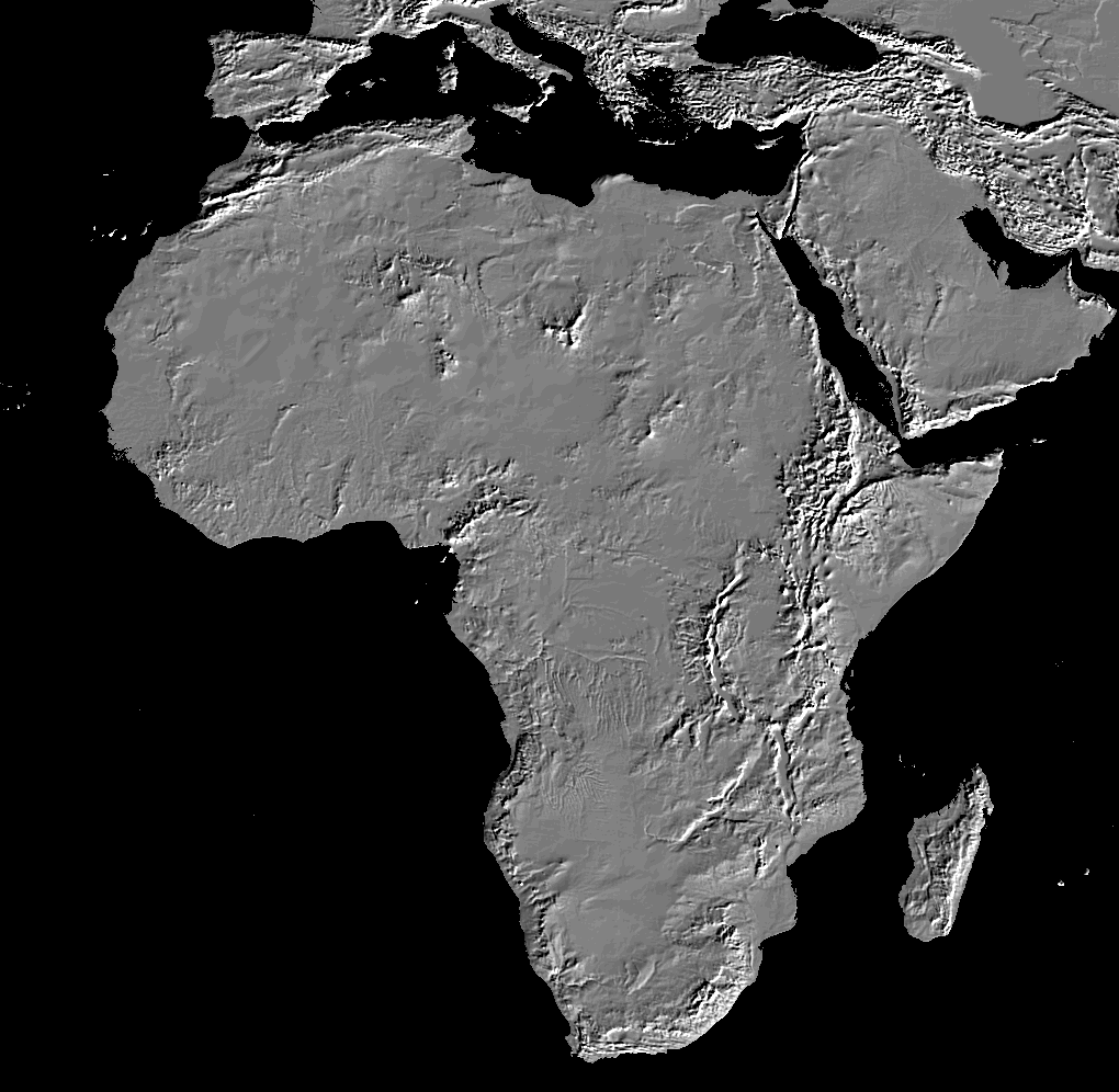
The two independent methods of age dating (radiocarbon and luminescence) of the rich faunal assemblage (a total of more than 10,000 bones from the combined assemblages of this study and that of Barthelme) provide strong support for the appearance of pastoralism in East Africa at ~4000 BP (Barthelme 1985; Marshall and Hildebrand 2002; Wendorf and Schild 2001). The domestication of cattle is thought to have occurred in the Fertile Crescent by 10,000 years ago (Zeder 2008) and then spread into North Africa (~8000 BP) perhaps as early as 9000 BP. These were the humpless cattle (Bos Taurus), and they gradually migrated, with caprines, into East Africa through the Rift Valley (4000 BP) and into South Africa by 2000 BP (Fig. 11). The migration occurred on the declining limb of the African Humid Period (Fig. 1): as the climate deteriorated, the hunting of large animals would have become more difficult (Behnke 1993). Marshall and Hildebrand (2002) argue that the movement of domesticated cattle could be controlled on a day-to-day basis and thus diminished the risk of paucity of wild animals and thus herding created “a dense, movable concentration of resources.”

Migration of pastoralism into Africa. Map diagrammatically depicts the slow migration of domesticated animals in to Africa during the Holocene: 8000 BP in the Sahara, 4000 BP in Kenya, and 2000 BP in South Africa. The timing and route are thought to be related to climate (Chritz et al. 2015; Smith 1992) and insect-borne disease. Increasing aridity drove pastoralist to better watered areas along the Nile and then into the Rift Valley. These areas were also tsetse fly free because of low annual rainfall (base image: National Geophysical Data Center (NGDC), https://www.ngdc.noaa.gov/mgg/topo/img/afs2.gif
There is a likely link between climate change and the gradual spread of pastoralism into Africa. The available moisture and lush vegetation in North Africa was at its maximum in the early Holocene (Kutzbach et al. 1996); but with decreasing solar radiation in the middle to late Holocene, the increasing aridity appeared to have forced herders out of the Sahara region. Thus, as the ecology changed, pastoralism moved into the Nile drainage at 8000 BP (Banks 1984; Close and Wendorf 1992; Wendorf and Schild 2001) and south through the East Africa Rift System to the Lake Turkana region. Drying also opened tsetse-free corridors allowing the migration of herds to the east and south (Fig. 11) (Gifford-Gonzalez 2000). Tsetse flies carry trypanosomiasis, which kills cattle; however, flies are absent from regions receiving <500 mm precipitation annually. Increasing aridity would have opened up new grazing and browsing resources as lakes shrank and forests receded to higher elevations (Bower 1988; Chritz et al. 2015; Gifford-Gonzalez 1998; Robbins 2006). So, in addition to fishing and hunter-gathering, herding was added to the subsistence strategy options. Pastoralism continued to move southward and the track of migration seems to have split moving both southwestward through Zimbabwe, Botswana, and Namibia and southward through Mozambique arriving in South Africa by 2000 BP (Hanotte et al. 2002; Henshilwood 1996; Horsburgh and Rhines 2010; Robbins et al. 2005; Sealy and Yates 1994; Smith 1992).
Lake Turkana levels fluctuated with climate change (Owen et al. 1982). An apparent dramatic short-term lowering occurred at ~6500 BP and then fluctuating levels between 5000 and 2000 BP reached high, spillover levels before dropping to modern lake level (Fig. 3). Other archaeological sites in the region, not so precisely dated as Dongodien, also recorded domesticated animals at this time (Ambrose 1998; Marean 1992; Robbins 1984). At Dongodien, both occupations (B and A) are interpreted as shoreline sites (Fig. 3).
Conclusions
The sedimentary sequence at Dongodien recorded climate-driven lake level changes. A quartz-OSL date of the archaeologically rich Horizon B, 4.14 ± 0.27 ka, is consistent with calibrated radiocarbon ages (ka) of charcoal from fire pits in the same horizon: 4.71 ± 0.13 ka cal BP, 4.79 ± 0.08 ka cal BP, and 4.70 ± 0.06 ka cal BP. The upper archaeologically rich bed (Horizon A) yielded an age of 2.34 ± 0.20 ka. The interpretation of the OSL-dated sites as beach encampments is consistent with the published Turkana Lake level curve of Owen et al. (1982): highstands at 10,000–7000 BP, 6000–4500 BP, and ~3000 BP. OSL dating has been shown to be a valuable dating tool for archaeological sites occurring in sand.
The OSL-dated, archaeologically rich layer with nearly 10,000 artifacts from this and Barthelme’s 1981 study suggests repeated occupations during the period of increasing aridity at the end of the African Humid Period. The site was fortuitously situated within the north–south corridor that was apparently tsetse free and was used by herders migrating from North Africa to South Africa in the late Holocene. Dongodien is the oldest, firmly dated site in East Africa containing archaeological evidence of domestic animals. The dropping lake level would have exposed well-watered pasture on lake-margin slopes and likely had cooling breezes and fewer insects. The location of GaJi4 on the cuspate foreland, Koobi Fora, near an area of upwelling, may have afforded the herders with a rich fishing area, as well.
Dongodien (GaJi4) was a shoreline encampment whose occupants possessed domestic cattle and caprines (goats and sheep), hunted small wild animals, and fished. Burned bones and a few cut-marked bones suggest butchering and cooking. The archaeological-rich horizon yielded a diverse assemblage of artifacts suggesting a mixture of subsistence strategies (hunting and gathering, fishing, and herding animals) rather than a single type of subsistence practice. A relatively high level of artifact reduction may mean that the GaJi4 tool kit was lighter, more easily transported by nomadic people who moved frequently because of limited resources associated with increasing aridity.
References
Ambrose, S. H. (1984). Holocene environments and human adaptation in the Central Rift Valley, Kenya. Berkeley: University of California-Berkeley.
Ambrose, S. H. (1998). Chronology of the later Stone Age and food production in East Africa. Journal of Archaeological Science, 25, 377–392.
Ammerman, A. J., Gifford, D. P., & Voorrips, A. (1978). Toward an excavation of a Kenyan pastoralist site. In I. Hodder (Ed.), Simulation studies in archaeology (pp. 123–136). Cambridge: Cambridge University Press.
Ashley, G. M., Ndiema, E. K., Spencer, J. Q. G., Harris, J. W. K., & Kiura, P. W. (2011). Paleoenvironmental context of archaeological sites: Implications for subsistence strategies under Holocene climate change, northern Kenya. Geoarchaeology: An International Journal, 26, 809–837.
Banks, K. M. (1984). Climates, cultures and cattle: The Holocene archaeology of the eastern Sahara. Dallas: Southern Methodist University Press.
Barthelme, J. W. (1981). Late Pleistocene-Holocene prehistory northeast of Lake Turkana, Kenya. Berkeley: University of California.
Barthelme, J. W. (1985). Fisher-hunters and Neolithic pastoralists in eastern Turkana, Kenya. Oxford: BAR International Series 254.
Barut, S. K. (1999). Hunter-gatherer land use patterns in later Stone Age. Journal of Anthropological Archaeology, 18, 165–200.
Behnke, R. H. (1993). Range ecology at disequilibrium: New models of natural variability and pastoral adaptation in African savannas. London: Overseas Development Institute.
Bloszies, C., Forman, S. L., & Wright, D. K. (2015). Water level history for Lake Turkana, Kenya in the past 15,000 years and a variable transition from the African Humid Period to Holocene aridity. Global and Planetary Change, 132, 64–76.
Bower, J. (1988). Evolution of Stone Age food-producing cultures in East Africa. In J. Bower & D. Lubell (Eds.), Prehistoric cultures and environments in the Late Quaternary of Africa (pp. 91–114). Oxford: BAR International Series.
Bower, J. R. F. (1991). The Pastoral Neolithic of East Africa. Journal of World Prehistory, 5, 48–82.
Brooks, N. (2006). Cultural responses to aridity in the Middle Holocene and increased social complexity. Quaternary International, 151, 29–49.
Brown, J., Lynch, A. H., & Marshall, A. G. (2009). Variability of the Indian Ocean Dipole in coupled model paleoclimate simulations. Journal of Geophysical Research: Atmospheres, 114(D11).
Butzer, K. W. (1980). The Holocene lake plain of North Rudolf, East Africa. Physical Geography, 1, 42–58.
Butzer, K. W., Brown, F. H., & Thurber, D. L. (1969). Horizontal sediments of the lower Omo Valley: The Kibish Formation. Quaternaria, 11, 15–29.
Butzer, K. W., Isaac, G. L., Richardson, J. L., & Washbourn-Kamau, C. (1972). Radiocarbon dating of the East African lake levels. Science, 175, 1069–1076.
Choi, J. H., Duller, G. A. T., Wintle, A. G., & Cheong, C.-S. (2006). Luminescence characteristics of quartz from the southern Kenyan Rift Valley: Dose estimation using LM-OSL SAR. Radiation Measurements, 41, 847–854.
Chritz, K. L., Marshall, F. B., Esperanza Zagal, M., Kirerae, F., & Cerling, T. E. (2015). Environments and trypanosomiasis risks for early herders in the later Holocene of the Lake Victoria basin, Kenya. PNAS, 112, 3674–3679.
Close, A., & Wendorf, F. (1992). The beginnings of food production in the eastern Sahara. In A. B. Gebauer & T. D. Price (Eds.), Transition to agriculture in prehistory (pp. 63–72). Madison: Prehistory Press.
Coe, M. J., Cumming, D. H., & Phillipson, J. (1976). Biomass and production of large African herbivores in relation to rainfall and primary production. Oecologia, 22, 341–354.
Coplen, T. B., Kendall, C., & Hopple, J. (1983). Comparison of stable isotope reference samples. Nature, 302, 236–238.
de Menocal, P. B. (2001). Cultural responses to climate change during the late Holocene. Science, 292, 667–673.
de Menocal, P. B., Ortiz, J., Guilderson, T., Adkins, J., Sarnthein, M., Baker, L., & Yarusinsky, M. (2000). Abrupt onset and termination of the African Humid Period: Rapid climate responses to gradual insolation forcing. Quaternary Science Reviews, 19, 347–361.
Ellis, J. E., Galvin, K. A., McCabe, J. T., & Swift, D. M. (1987). Pastoralism and drought in Turkana District, Kenya. Nairobi: A report to NORAD.
Feibel, C. S. (2011). A geological history of the Turkana basin. Evolutionary Anthropology, 20, 206–216.
Folk, R. L. (1980). Petrology of sedimentary rocks. Austin: Hemphill Publishing Company.
Forman, S. L., Wright, D. K., & Bloszies, C. (2014). Variations in water level for Lake Turkana in the past 8500 years near Mt. Porr, Kenya and the transition from the African Humid Period to Holocene aridity. Quaternary Science Reviews, 97, 84–101.
Frostick, L. E., & Reid, I. (1986). Evolution and sedimentary character of lake deltas fed by ephemeral rivers in the Turkana basin, northern Kenya. In L. E. Frostick, R. W. Renaut, I. Reid, & J. J. Tiercelin (Eds.), Sedimentation in the African rifts (pp. 113–125). London: Blackwell Scientific Publications.
Garcea, E. A. A. (2006). Semi-permanent foragers in semi-arid environments of North Africa. World Archaeology, 38, 197–219.
Garcea, E. A. A., & Hildebrand, E. A. (2009). Shifting social networks along the Nile: Middle Holocene ceramic assemblages from Sai Island, Sudan. Journal of Anthropological Archaeology, 28, 304–322.
Garcin, Y., Melnick, D., Strecker, M. R., Olago, D., & Tiercelin, J.-J. (2012). East African mid-Holocene wet-dry transition recorded in palaeo-shorelines of Lake Turkana, northern Kenya Rift. Earth and Planetary Science Letters, 331-332, 322–334.
Gifford, D. P., Isaac, G. L., & Nelson, C. (1980). Evidence for predation and pastoralism at prolonged drift: A pastoral Neolithic site in Kenya. Azania, 15, 57–108.
Gifford-Gonzalez, D. (1985). Faunal assemblages from Masai Gorge rockshelter and Marula rockshelter. Azania: Archaeological Research in Africa, 20, 69–88.
Gifford-Gonzalez, D. (1991). Bones are not enough: Analogues, knowledge, and interpretive strategies in zooarchaeology. Journal of Anthropological Archaeology, 10, 215–254.
Gifford-Gonzalez, D. (1998). Early pastoralists in East Africa: Ecological and social dimensions. Journal of Anthropological Archaeology, 17, 166–200.
Gifford-Gonzalez, D. (2000). Animal disease challenges to the emergence of pastoralism in sub-Saharan Africa. African Archaeological Review, 17, 95–139.
Gifford-Gonzalez, D., Stewart, K. M., & Rybczynski, N. (1999). Human activities and site formation at modern lake margin foraging camps in Kenya. Journal of Anthropological Archaeology, 18, 397–440.
Guerin, G., Mercier, N., & Adamiec, G. (2011). Dose-rate conversion factors: Update. Ancient TL, 29, 5–8.
Hanotte, O., Bradley, D. G., Ochieng, J. W., Verjee, Y., Hill, E. W., & Rege, J. E. O. (2002). African pastoralism: Genetic imprints of origins and migrations. Science, 296, 336–339.
Henshilwood, C. (1996). A revised chronology for pastoralism in southernmost Africa: New evidence for sheep at c. 2000 BP from Blombos Cave, South Africa. Antiquity, 70, 945–949.
Hilgen, F. J. (1991). Astronomical calibration of Gauss to Matuyama sapropels in the Mediterranean and implication for the geomagnetic polarity time scale. Earth and Planetary Science Letters, 104, 226–244.
Horsburgh, K. A., & Rhines, A. (2010). Genetic characterization of an archaeological sheep assemblage from South Africa’s Western Cape. Journal of Archaeological Science, 37, 2906–2910.
Kamau, J. (1991). John Kamau field notes. Archaeological Section Database, National Musuems of Kenya.
Kiura, P. W. (2005). An ethnoarchaeological and stable isotope analysis of the diets of three modern groups of people living in northern Kenya. PhD dissertation, Rutgers University.
Kropelin, S., Verschuren, D., Lezine, A. M., Eggermont, H., & Cocquyt, C. (2008). Climate-driven ecosystem succession in the Sahara: The past 6000 years. Science, 320, 765–768.
Kutzbach, J. E. (1981). Monsoon climate of the early Holocene: Climate experiment with Earth’s orbital parameters for 9,000 years ago. Science, 214, 59–61.
Kutzbach, J. E., & Street-Perrott, F. A. (1985). Milankovitch forcing of fluctuations in the level of tropical lakes from 18 to 0 kyr B.P. Nature, 317, 130–134.
Kutzbach, J. E., Bonan, G., Foley, J., & Harrison, S. P. (1996). Vegetation and soil feedbacks on the response of the African monsoon to orbital forcing in the early to middle Holocene. Nature, 384, 623–626.
Leakey, L. S. B. (1935). The Stone Age races of Kenya. London: Oxford University Press.
Marchant, R., Mumbi, C., Behera, S., & Yamagata, T. (2006). The Indian Ocean dipole—the unsung driver of climatic variability in East Africa. African Journal of Ecology, 45, 4–16.
Marean, C. W. (1992). Hunter to herder: Large mammal remains from hunter-gatherer occupation at Enkapune ya Muto rockshelter. African Archaeological Review, 10, 65–127.
Marshall, F. B. (1986). Aspects of the advent of pastoral economies in East Africa. Berkeley: University of California.
Marshall, F. B. (1990). Origins of specialized pastoral production in East Africa. American Anthropologist, 92, 873–894.
Marshall, F. B. (1994). Archaeological perspectives on East African pastoralism. In E. Fratkin, K. Galvin, & E. Roth (Eds.), African pastoralists systems: An integrated approach (pp. 17–43). London: Lynne Rienner Pub.
Marshall, F. B., & Hildebrand, E. (2002). Cattle before crops: The beginnings of food production in Africa. Journal of World Prehistory, 16, 99–143.
Marshall, F. B., Stewart, K., & Barthleme, J. W. (1984). Early domestic stock at Dongodien in northern Kenya. Azania, 19, 120–127.
Mohammed, M. U., Bonnefille, R., & Johnson, T. C. (1995). Pollen and isotopic records in Late Holocene sediments from Lake Turkana, Kenya. Palaeogeography, Palaeoclimatology, Palaeoecology, 119, 371–383.
Ndiema, E. K. (2011). Mobility and subsistence patterns among mid Holocene Pastoralist at Koobi Fora, Northern Kenya: New archaeological sites and evidence from obsidian sourcing and geochemical characterization. PhD dissertation, Rutgers University.
Ndiema, E. K., Dillian, C., & Braun, D. (2009). Interaction and exchange across the transition to pastoralism, Lake Turkana, Kenya. In C. Dillian & C. White (Eds.), Trade and exchange: Archaeological studies from prehistory and history (pp. 95–110). New York: Springer.
Ndiema, E. K., Dillian, C. D., Braun, D. R., Harris, J. W. K., & Kiura, P. W. (2011). Transport and subsistence patterns at the transition to pastoralism, Koobi Fora, Kenya. Archaeometry, 53, 1085–1098.
Nicholson, S. (2000). The nature of rainfall variability over Africa on time scales of decades to millenia. Global and Planetary Change, 26, 137–158.
Owen, R. B. (1981). Quaternary diatomaceous sediments and the geological evolution of lakes, Turkana, Baringo and, Bogoria, Kenya, Rift Valley. PhD dissertation, University of London.
Owen, R. B., & Renaut, R. W. (1986). Sedimentology, stratigraphy, and palaeoenvironments of the Holocene Galana Boi Formation, NE Lake Turkana, Kenya. In L. E. Frostick, R. W. Renaut, I. Reid, & J. J. Tiercelin (Eds.), Sedimentation in the African Rifts (pp. 311–322). London: Blackwell Scientific Publications.
Owen, R. B., Barthelme, J. W., Renaut, R. W., & Vincens, A. (1982). Palaeolimnology and archaeology of Holocene deposits north-east of Lake Turkana, Kenya. Nature, 198, 523–529.
Phillipson, D. W. (1977). Lowasera. Azania, 12, 1–32.
Phillipson, D. W. (1984). Early food-production in central and southern Africa. In J. D. Clark & S. A. Brandt (Eds.), From hunters to farmers: The causes and consequences of food production in Africa (pp. 272–280). Berkeley: University of California Press.
Plint, A. G. (2010). Wave- and storm-dominated shoreline and shallow-marine systems. In N. P. James & R. W. Dalrymple (Eds.), Facies Model 4 (pp. 167–199). St. Johns: Geological Association of Canada.
Pokras, E. M., & Mix, A. C. (1987). Earth’s precession cycle and Quaternary climatic change in tropical Africa. Nature, 326, 486–487.
Renaut, R. W., & Gierlowski-Kordesch, E. H. (2010). Lakes. In N. P. James & R. W. Dalrymple (Eds.), Facies models 4 (pp. 541–575). St. Johns: Geological Association of Canada.
Robbins, L. H. (1972). Archaeology in Turkana District, Kenya. Science, 176, 359–366.
Robbins, L. H. (1974). The Lothagam site: A late stone age fishing settlement in the Lake Rudolph basin, Kenya. PhD dissertation, Michigan State University.
Robbins, L. H. (1984). Late prehistoric aquatic and pastoral adaptions west of Lake Turkana, Kenya. In J. D. Clark & S. A. Brandt (Eds.), From hunters to farmers (pp. 206–211). Berkeley: University of Califormia Press.
Robbins, L. H. (2006). Lake Turkana archaeology: The Holocene. Ethnohistory, 53, 71–93.
Robbins, L. H., Campbell, A. C., Murphey, M. L., Brook, G. A., Srivastava, P., & Badenhorst, S. (2005). The advent of herding in southern Africa: Early AMS dates on domestic livestock from the Kalahari Desert. Current Anthropology, 46, 671–677.
Ruddiman, W. F. (2000). Earth’s climate, past and future. New York: W.H. Freeman and Co..
Sadr, K. (2008). Invisible herders? The archaeology of Khoekhoe pastoralists. Southern African Humanities, 20, 179–203.
Sealy, J., & Yates, R. (1994). The chronology of the introduction of pastoralism to the Cape, South Africa. Antiquity, 69, 58–67.
Smith, A. B. (1992). Origins and spread of pastoralism in Africa. Annual Review of Anthropology, 21, 125–141.
Smith, A. B. (2005). African herders: Emergence of pastoral traditions. Walnut Creek: Alta Mira Press.
Street, F. A., & Grove, A. T. (1979). Global maps of lake level fluctuations since 30,000 BP. Quaternary Research, 12, 83–118.
Street-Perrott, F. A., & Harrison, S. P. (1983). Lake levels and climate reconstruction. In A. D. Hecht (Ed.), Paleoclimate data and modeling (pp. 291–340). New York: J. Wiley and Sons.
Street-Perrott, F. A., & Roberts, N. (1983). Fluctuations in closed-basin lakes as an indicator of past atmospheric circulation patterns. In F. A. Street-Perrott, M. Beran, & R. A. S. Ratcliffe (Eds.), Variations in the global water budget (pp. 331–345). Oxford: Reidel Dordrecht.
Thompson, L. G., Mosley-Thompson, E., Davis, M. E., Henderson, K. A., Brecher, H. H., Zagorodnov, V. S., Mashiotta, T. A., Lin, P.-N., Mikhalenko, V. N., Hardy, D. R., & Beer, J. (2002). Kilimanjaro ice core records: Evidence of Holocene climate change in tropical Africa. Science, 298, 589–593.
Tierney, J. E., Smerdon, J. E., Anchukaitis, K. J., & Seager, R. (2013). Multidecadal variability in East Africa hydroclimate controlled by the Indian Ocean. Nature, 493, 389–392.
Vandenberghe, D., De Corte, F., Buylaert, J.-P., Kučera, J., Van den haute, P. (2008). On the internal radioactivity in quartz. Radiation Measurements, 43(2-6), 771–775.
Verschuren, D., Laird, K. R., & Cumming, B. F. (2000). Rainfall and drought in equatorial east Africa during the past 1,100 years. Nature, 403, 410–414.
Wendorf, F., & Schild, R. (2001). Holocene settlement of the Egyptian Sahara: The archaeology of Nabia Playa. New York: Plenum.
Wright, D. K., Forman, S. L., Kiura, P., Bloszies, C., & Beyin, A. (2015). Lakeside view: Sociocultural responses to changing water levels of Lake Turkana, Kenya. African Archaeological Review, 32, 335–367.
Yellen, J. E., & Harpending, H. C. (1972). Hunter-gatherer populations and archaeological inference. World Archaeology, 4, 244–253.
Yuretich, R. F. (1979). Modern sediments and sedimentary processes in Lake Rudolf (Lake Turkana) eastern Rift Valley, Kenya. Sedimentology, 26, 313–331.
Yuretich, R. F., & Cerling, T. E. (1983). Hydrogeochemistry of Lake Turkana, Kenya: Mass balance and mineral reactions in an alkaline lake. Geochimica et Cosmochimica Acta, 47, 1099–1109.
Zeder, M. A. (2008). Domestication and early agriculture in the Mediterranean Basin: Origins, diffusion, and impact. PNAS, 105, 11597–11604.
Acknowledgements
We appreciate the financial support from the National Museums of Kenya (Idle Farah, DG) through the Koobi Fora Field School and Wenner-Gren grant fellowship to E. Ndiema; an International Collaborative Research Grant from Wenner-Gren to J.W.K. Harris; and a grant from Climate and Environmental Change Initiative (CECI), Rutgers University, to G.M. Ashley and J.W.K. Harris. We thank James Wright and Richard Mortlock for stable isotope analyses. Sébastien Huot is thanked for the use of his Minimum Age Model spreadsheet and Jennifer Roozeboom for assistance with the OSL sample preparation. We are grateful to assistance in the field from Paul Watene, Tom Mukhuyu, and Ben Sila. Discussions with Birgit Keding, Emma Mbua, Carolyn Dillian, and David Braun were very helpful as we developed our model. Special thanks go to Jeremy Delaney for assistance with the preparation of the manuscript. All data were collected under a permit from the National Museums of Kenya (Dr. Idle Farah, Director). Hélène Avocat is thanked for French abstract translation. Two anonymous reviewers provided constructive and supportive comments that improved the manuscript.
Author information
Authors and Affiliations
Corresponding author
Ethics declarations
Conflict of Interest
The authors declare that they have no conflict of interest.
Electronic Supplementary Material
ESM 1
(DOCX 19 kb)
Rights and permissions
About this article

Cite this article
Ashley, G.M., Ndiema, E.K., Spencer, J.Q.G. et al. Paleoenvironmental Reconstruction of Dongodien, Lake Turkana, Kenya and OSL Dating of Site Occupation During Late Holocene Climate Change. Afr Archaeol Rev 34, 345–362 (2017). https://doi.org/10.1007/s10437-017-9260-4
Published:
Issue Date:
DOI: https://doi.org/10.1007/s10437-017-9260-4