
Abstract
The intensity-duration (I-D) threshold is considered an effective indicator for landslides triggered by short-term high-intensity rainfall and long-term low-intensity rainfall. However, previous studies have not considered the influence of antecedent rainfall. Herein, we analyzed hourly rainfall data for 613 shallow landslides that occurred from 1963 to 2018 in South Korea to obtain rainfall thresholds and investigated the effect of antecedent rainfall conditions on threshold variations. The I-D and IMAP-D, which is normalized by dividing I by mean annual precipitation (MAP), thresholds were determined to be I = 10.40D–0.31 and IMAP = 0.006D–0.26 (4 ≤ D (h) ≤ 84), respectively, at the 2nd percentile level through quantile regression analysis. These thresholds were lower than other local thresholds (i.e., excluding global and regional thresholds), suggesting that the southern region of the Korean Peninsula was more susceptible to rainfall-induced landslides. Although the effective length of antecedent rainfall was not presented herein, the I-D threshold of landslide-triggering rainfall was confirmed to be low for the absolute and/or calibrated antecedent rainfalls greater than event cumulative rainfall at 5, 7, 10, and 20 days prior to the event. Such differences in I can be greater at shorter durations; however, these differences gradually decrease as D increases, suggesting that they lose their effect as soil water content increases. The results of the current study can improve the understanding of the effect of antecedent rainfall conditions on landslide occurrence and should be further tested with respect to the hydrologic response of hillslopes by considering regional climate and local site conditions.
Introduction
Landslides are natural phenomena that cause the erosion of the Earth’s surface, which often cause personal injury and property damage (Sidle and Ochiai 2006). South Korea has a high percentage of mountainous regions, and many residences and infrastructure are located in piedmont areas. In summer, the majority of the annual precipitation is concentrated over 4 months (June to September), which increases the potential risks of landslides. Therefore, it is critical to understand the factors that affect the probability of landslide occurrence in order to predict and prevent landslide damage.
Among various factors affecting landslide occurrence, rainfall is the most widely recognized extrinsic landslide triggers (Wieczorek 1996). Rainfall triggers landslides by increasing pore water pressures, thereby causing a decrease in shear strength (Brand 1981; Terlien 1998). Particularly, heavy rainfall can quickly shift the slope from a marginally stable to an actively unstable state. In any given region, the rainfall threshold for rainfall-initiated landslides can be identified if the slope maintains a marginal stability. This rainfall threshold can be used to estimate the probability of landslide occurrence and can thus be used to establish landslide warning and evacuation procedures (Crozier 1999; Glade and Crozier 2005). Therefore, many studies have focused on the calculation of rainfall thresholds for the relationship between rainfall and landslide occurrence using physical (e.g., process-based, theoretical) (Montgomery and Dietrich 1994; Wu and Sidle 1995; Crosta 1998; Terlien 1998; Crozier 1999; Crosta and Frattini 2003; Baum et al. 2010; Peres and Cancelliere 2014) or empirical (e.g., historical, statistical) models (Campbell 1975; Caine 1980; Choi 1986; Crozier and Glade 1999; Aleotti 2004; Wieczorek and Glade 2005; Guzzetti et al. 2007, 2008; Cannon et al. 2008; Dahal and Hasegawa 2008; Saito et al. 2010; Giannecchini et al. 2012; Martelloni et al. 2012; Kim et al. 2013a; Segoni et al. 2014).
Empirical models have been successfully applied at regional and global scales despite lacking the detailed information (i.e., meteorological, geological, morphological, and geotechnical data) for the field sites, because they can be derived relatively easily from the relationship between historical landslides and rainfall records (Caine 1980; Guzzetti et al. 2007, 2008; Cannon et al. 2008; Saito et al. 2010; Martelloni et al. 2012). Among the several types of empirical thresholds (cf. Guzzetti et al. 2007, 2008), the combination of rainfall intensity and duration (i.e., intensity-duration threshold), first proposed by Caine (1980), has been commonly used to predict the possible occurrence of landslides (Choi 1986; Aleotti 2004; Guzzetti et al. 2007, 2008; Dahal and Hasegawa 2008; Saito et al. 2010; Giannecchini et al. 2012; Martelloni et al. 2012; Kim et al. 2013a; Segoni et al. 2014; Chen et al. 2015), although the effects of high rainfall intensity or hourly rainfall patterns associated with landslide occurrence have not been considered by normalizing the rainfall conditions. This concept has been recognized as a useful criterion to predict the possible occurrence of landslides and to establish warning and evacuation procedures (Choi 1986; Keefer et al. 1987; Terlien 1998; Aleotti 2004; Chen et al. 2005; Guzzetti et al. 2008; Dahal and Hasegawa 2008; Kim et al. 2013a; Segoni et al. 2015).
Generally, rainfall-initiated landslides are strongly governed by rainfall characteristics at the time of the rainfall event, but they can also be affected by antecedent rainfall (i.e., rainfall preceding a rainfall event). Antecedent rainfall is an important factor to determine the initial soil matric suction conditions by inducing gradual increases in soil moisture and groundwater level, which can influence the initiation of landslides (Lee et al. 2012). Based on real-time monitoring of four slopes in Singapore, Rahardjo et al. (2008) demonstrated that the role of antecedent rainfall in the development of the worst pore-water pressure condition was more significant in residual soils with low permeability than in those with high permeability. The effect of antecedent rainfall on variations in slope stability has been reported in several numerical studies. Rahardjo et al. (2001) found that slope instability can be induced by antecedent rainfall owing to a decrease in the safety factor. Rahimi et al. (2011) also confirmed that the pattern of antecedent rainfall significantly influences slope stability by controlling the rate of decrease of the safety factor. Kim et al. (2013b) demonstrated that antecedent rainfall may decrease the matric suction of the soil, and thus trigger slope instability. Several empirical studies have also examined the influence of antecedent rainfall on the initiation of landslides using the relationship between daily rainfall and antecedent rainfall (or cumulative rainfall) (Kim et al. 1991; Glade et al. 2000; Dahal and Hasegawa 2008; Giannecchini et al. 2012) or the combination of mean daily rainfall intensity and rainfall duration in days (Hasnawir and Kubota 2008; Khan et al. 2012). Nonetheless, these empirical studies have mainly focused on simple comparisons between daily rainfall and antecedent rainfall amounts or the intensity-duration (I-D) thresholds of continuous rainfall events (including antecedent rainfall) because of the difficulty in defining specific rainfall events or antecedent rainfall at an hourly scale, likely due to the lack of information during the landslide occurrence itself. Consequently, there is still uncertainty surrounding the influence of antecedent rainfall on the I-D thresholds for the initiation of landslides at an hourly scale in empirical studies. In this respect, several studies have mentioned the need to establish I-D thresholds that account for antecedent rainfall conditions for empirical approaches (Dahal and Hasegawa 2008; Saito et al. 2010; Kim et al. 2013a).
Therefore, this study aimed to (1) obtain new I–D thresholds for the initiation of shallow landslides using data from 613 historic landslides in South Korea, including occurrence time and location, and corresponding hourly rainfall data; (2) discuss the characteristics of landslide occurrence by comparing global, regional, and local I-D thresholds derived from international studies; (3) examine the influence of antecedent rainfall on I-D thresholds for the initiation of shallow landslides based on the exact definition of a rainfall event on an hourly basis.
Materials and methods
Environmental settings related to landslide occurrence
South Korea is located at mid-latitude (33–39° N) (Fig. 1) and is strongly influenced by the East Asian Monsoon, and therefore exhibits temperate climate characteristics. According to meteorological data from the past three decades, the mean annual temperature and mean annual precipitation in this area are 6.6–16.6 °C and 825.6–2007.3 mm, respectively, with substantial regional variations (Korea Meteorological Administration 2012). Most annual precipitation is concentrated in the rainy season between June and September and is significantly contributed by monsoon fronts from the end of June to the end of July, as well as localized convective rainstorms or typhoons from August to September (Park et al. 2008; KMA 2011).

Distribution map of the 613 shallow landslides (1963–2018) analyzed in this study
Approximately 64% of the entire land area is comprised of mountainous terrain, of which 62.5% has a slope angle that exceeds 30° (Korea Research Institute for Human Settlements 2008). Except for some steep regions, most of the mountains in South Korea are hilly or low mountains undergoing weak isostatic uplift due to erosion and weathering over a long time period, with altitudes of 500 m above sea level (Fig. 1; National Institute for Disaster Prevention 2003). The geology is comprised of 42.6% metamorphic rocks, 34.8% igneous rocks, and 22.6% sedimentary rocks (National Geographic Information Institute 2010).
Landslides occur frequently during June and September (Fig. 2), which corresponds with the raining season. This strongly suggests that rainfall is a primary landslide trigger in South Korea. The most common types of landslides are shallow transitional slides, which occur dominantly in granite and metamorphic rocks (Kim and Chae 2009) and are relatively small (i.e., typically less than 2 m in depth, 20 m in width, and 100 m in length, on average) (Choi 1986; Yoo et al. 2012).

Monthly distribution of shallow landslide events and mean precipitation during 2000–2018
Data collection
Landslide data
We analyzed 613 shallow landslides that occurred across the whole country from 1963 to 2018 (Fig. 1). This information was collected from research articles covering landslide disasters, major national and local newspapers (on- or off-line), and scientific reports (Fig. 3a). Particularly, landslide data from the 1960s to the early 1990s were mostly collected from the Naver News Library website (http://newslibrary.naver.com), which provides historic daily newspapers. Newspaper articles have been used as a useful source of landslide occurrence data in several previous studies (Chen et al. 2005; Dahal and Hasegawa 2008; Giannecchini et al. 2012; Rosi et al. 2012). The information on landslide occurrence completely or partially included the following details: (a) information source, (b) time of landslide occurrence, (c) location of landslide occurrence, (d) distance to rainfall station, (e) type of landslide, (f) area of landslide scar, and (g) depth of landslide scar (Fig. 3). The information of exact or approximate time and location (specific site or village) was available for all 613 landslide occurrences (100%) (Fig. 3b,c). The distance of the landslide location to the closest rainfall station was distributed as follows: 109 landslides (17.8%) were within a ≤ 2 km distance; 174 landslides (28.4%) were within a distance >2 km, but ≤4 km; 161 landslides (26.3%) were within a distance >4 km, but ≤6 km; 105 landslides (17.1%) were within a distance >6 km, but ≤8 km; 43 landslides (7.0%) were within a distance >8 km, but ≤10 km; finally, 21 landslides (3.4%) were within a > 10 km, but ≤13 km distance (Fig. 3d). A total of 531 landslides were classified as shallow (86.6%), 78 as transitional (shallow landslide and debris flow; 12.7%), and 4 as rockslides (0.7%) (Fig. 3e). There was limited data on the area and/or depth of landslide scars: 20 landslides (3.3%) had an area of ≤1000 m2; 5 landslides (0.8%) had an area of >1000 m2, but ≤2000 m2; and 6 landslides (1.0%) had a > 2000 m2 area (Fig. 3f). Finally, 14 landslides (2.3%) had a scar depth of ≤1.5 m and 4 landslides (0.7%) had a depth > 1.5 m, but ≤3.0 m (Fig. 3g).

Data categories derived from the 613 landslides analyzed in this study. a Information source. b Time of landslide occurrence. c Location of landslide occurrence. d Distance to rainfall station. e Type of landslide. f Area of landslide scar. g Depth of landslide scar
Rainfall data
In this study, the hourly rainfall data corresponding to the occurrence of 613 landslides was collected from a total of 216 meteorological stations across the country: 92 stations belonged to the Korea Meteorological Administration (http://data.kma.go.kr), one station belonged to the Korea Aviation Meteorological Office (http://amo.kma.go.kr), two stations belonged to the Korea Forest Service (http://mw.nifos.go.kr), 85 stations belonged to the Korea Ministry of Environment, 35 stations belonged to the Korea Water Resource Corporation, and one station belonged to the Korea Hydro & Nuclear Power Co., Ltd. (http://wamis.go.kr). These data were obtained from the stations closest to the individual landslide locations with no missing values. In the current study, interpolation methods could not be used to analyze the antecedent rainfall because of lack of continuous hourly rainfall data at many adjacent weather stations, particularly for landslides that occurred during the 1960s–1980s. Owing to this limitation, a total of 613 landslides located within a maximum distance of 13 km (the average distance between meteorological stations in South Korea; National Geographic Information Institute, 2016) from meteorological stations (Fig. 3d) were analyzed using the original hourly rainfall data at each station. The average distance between the locations of landslides and meteorological stations was 4.6 ± 2.6 km (average ± standard deviation).
The mean annual precipitation (MAP) data were used to normalize the rainfall intensity associated with landslide occurrence. Here, 30-year average annual precipitation, defined as a climatological (standard) normal (World Meteorological Organization, 2007), was adopted as a representative value at a given region. MAP data corresponding to each landslide were obtained from the 73 nearest KMA weather stations possessing long-term observation data (KMA 1991; 2001; 2012).
Rainfall data analysis
Definition of a landslide-triggering rainfall event
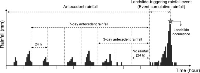
In this study, we defined a landslide-triggering rainfall event as an independent and continuous event from the beginning of the rainfall to the landslide occurrence, caused by the influence of the typhoons, monsoon fronts, or localized convective rainstorms. Landslide-triggering rainfall was characterized and analyzed in terms of intensity and duration, which were key factors determined by the identification of the rainfall event starting point (Aleotti 2004; Rosi et al. 2012; Peres and Cancelliere 2014; Segoni et al. 2015). Rosi et al. (2012) emphasized the need for the establishment of objective criteria, addressing concerns about the possibility of subjective intervention in the definition of event start point when deriving landslide-triggering rainfall thresholds. However, this cannot be easily achieved due to the coexistence of different rainfall patterns from various heavy rain types (i.e., typhoons, monsoon fronts, or localized convective rainstorms) in Korea (Kim et al. 2015), as noted by Rosi et al. (2012). Therefore, by following the methods of several previous domestic and international studies (Ministry of Land, Infrastructure and Transport 2004; National Institute for Disaster Prevention 2005; Saito et al. 2010; Park et al. 2018), the start of the landslide-triggering rainfall event was delimited by at least 24 h of no rainfall (Fig. 4). According to this definition, a 1-day antecedent rainfall meant that a rainfall event occurred 24 h before the start of the landslide-triggering rainfall, and was therefore always zero. Based on these definitions, mean intensity (I, mm h−1), duration (D, h) and event cumulative rainfall (ECR, mm) were used as rainfall indices for the landslide-triggering event.
Definition of the rainfall parameters used in this study
Rainfall threshold analysis
The landslide-triggering rainfall threshold was analyzed using intensity and duration based on the equation established by Caine (1980), as follows:
where α and β are regression coefficients. For this relationship, I-D plots are generally drawn with a double logarithmic scale, and their threshold is the regression line closest to the origin (Guzzetti et al. 2007; Saito et al. 2010).
To obtain the I-D landslide-triggering threshold, quantile regression was performed using the R statistics package (ver.2.15.2) (Koenker 2009). Quantile regression, which is a statistical tool used to estimate the tendency of a conditional quantile, has the advantage of being able to minimize the influence of independent variable outliers (Koenker 2005). Based on this, we analyzed the 2nd and 50th percentiles, and the regression line of the 2nd and 50th percentiles were determined as the threshold and general trend, respectively, according to the suggestions of Guzzetti et al. (2007) and Saito et al. (2010).
Moreover, the regional I-D thresholds are limited by the incomparability between the thresholds of different regions due to differences in topography and lithology and variations in meteorology (Jakob and Weatherly 2003). Therefore, the I-D thresholds were normalized by dividing rainfall intensity by MAP (IMAP) to eliminate the effects of regional variability and to enable comparison with previous studies. Additionally, IMAP-D is frequently used as an alternative approach to represent the landslide-triggering rainfall thresholds (Jibson 1989; Guzzetti et al. 2007; Dahal and Hasegawa 2008; Saito et al. 2010; Chen et al. 2015).
Reconstruction and analysis of antecedent rainfall
To evaluate the effect of antecedent rainfall on shallow landslide-triggering I-D thresholds, we analyzed the cumulative antecedent rainfall for 3, 5, 7, 10, and 20 days using the following equation.
where AARxn is the cumulated antecedent rainfall for landslide-triggering rainfall event x, R1 is the daily (i.e., 24 h) rainfall for the day before the start of the landslide-triggering rainfall event x, and Rn is the daily rainfall for the nth day before the start of the landslide-triggering rainfall event x.
The effect of antecedent rainfall decreases over time due to drainage processes subtracting water from local storage (Canuti et al. 1985; Crozier 1989). Therefore, in order to consider the decreasing effect of antecedent rainfall on landslide occurrence, the reconstruction of the absolute antecedent rainfall was carried out using the following equation proposed by Crozier (1989):
where CARxn is the calibrated antecedent rainfall for landslide-triggering rainfall event x. The decay constant K, which typically ranges between 0.8 and 0.9, is an empirical value that depends on the drainage capacity of material and the hydrological properties of the area (Capecchi and Focardi 1988). In the current study, K = 0.9 was applied as a good assumption for a maximum of 20 antecedent days, making negligible rainfall occurred more than 20 days before a landslide occurrence after a few tentative trials, as in Marques et al. (2008) and Khan et al. (2012).
Furthermore, a study in Korea by Hong et al. (1990) proposed a simple method to decide whether landslides were induced by cumulative rainfall (i.e., antecedent rainfall) or daily rainfall using a 1:1 line in the relationship between cumulative rainfall before landslide occurrence and daily rainfall at landslide occurrence. This method has been used in several subsequent studies as a guideline to evaluate the effect of antecedent rainfall or daily rainfall on landslide occurrence (Kim et al. 1991; Crozier 1999; Dahal and Hasegawa 2008; Mathew et al. 2014). Based on this background, the differences in I-D conditions were analyzed as the dominant effect of ECR for y-axis biased plots and AAR or CAR for x-axis biased plots (via their relationship to the 1:1 line) in the relationships between landslide-triggering event cumulative rainfall and antecedent rainfall for 3, 5, 7, 10, and 20 days.
Results
Intensity-duration threshold
Figure 5 shows the relationship between I and D by plotting quantile regression lines in double logarithmic coordinates for shallow landslide-triggering events in South Korea. The values of I range from 1.9 mm h−1 (D = 49 h) to 41.7 mm h−1 (D = 5 h) and D ranges from 4 h (I = 20.8 mm h−1) to 84 h (I = 4.2 mm h−1) for shallow landslide triggering. For all percentiles analyzed, I decreased when D increased. Most landslides (77%, n = 469) were concentrated in the 10–40 h range from the beginning of the rainfall event.

I-D conditions and threshold for the initiation of shallow landslides in South Korea
The I-D threshold was determined from the 2nd percentile regression line as follows:
According to this threshold, rainfall events have the potential to trigger landslides after lasting only 4 h with a mean intensity of 6.77 mm h−1 (ECR = 27.07 mm) or lasting for a longer period of 84 h with a mean intensity of 2.63 mm h−1 (ECR = 221.20 mm).
Normalized intensity–duration threshold
Figure 6 shows the IMAP-D relationships for shallow landslide-triggering events in South Korea. IMAP ranged from 1.00 × 10⁻³ h−1 to 3.00 × 10⁻² h−1 (i.e., 0.1–3.0% of MAP) and decreased with increasing rainfall duration for the 2nd and 50th percentiles, as illustrated in Fig. 6.

IMAP-D conditions and threshold for the initiation of shallow landslides in South Korea
The IMAP-D threshold was also determined as the 2nd percentile regression line, and the derived equation was the following:
This threshold indicates that rainfall events ranging from 2.00 × 10⁻³ h−1 to 4.00 × 10⁻³ h−1 (i.e., 0.2–0.4% of MAP) for IMAP in any given duration have the potential to trigger landslides.
Influence of antecedent rainfall on I–D relationship
The I-D relationship corresponding to each ECR–AARn relationship for 3, 5, 7, 10, and 20 antecedent days is shown in Fig. 7. Here, the percentage of data points positioned above the 1:1 line (y-axis; i.e., the dominant effect of ECR) are 99.2% (n = 608), 96.9% (n = 594), 94.0% (n = 576), 89.2% (n = 547), and 48.0% (n = 294) for 3, 5, 7, 10, and 20 days of antecedent rainfall, respectively. The contribution of ECR on landslide occurrences was particularly significant compared to antecedent rainfall of up to 10 days prior to the event, whereas its contribution decreased as the number of analyzed antecedent rainfall days increased.

Relationships between event cumulative rainfall (ECR) and absolute antecedent rainfall (AAR), and differences in I-D thresholds by the relationship between event cumulative rainfall (ECR) and absolute antecedent rainfall (AAR) for 3 (a, f), 5 (b, g), 7 (c, h), 10 (d, i), and 20 (e, j) days
In all cases, when AARn ≥ ECR for the triggering of shallow landslides (Fig. 7a–e), landslides occurred after a relatively lower intensity or shorter duration rainfall (Fig. 7f–j) compared to cases where AARn < ECR. Particularly, significant I-D threshold differences were observed in cases with antecedent rainfalls of 5, 7, 10, and 20 days, for which a quantile regression analysis was accomplished. In the case of landslides with heavy antecedent rainfall (i.e., AARn ≥ ECR), the exponent β ranged between 0.23 and 0.29, which decreases as rainfall duration increases. Conversely, for the landslides with high event cumulative rainfall (i.e., AARn < ECR), the exponent β ranged between 0.41 and 0.79. The I-D thresholds obtained from the cases where AARn ≥ ECR and AARn < ECR for each antecedent day showed significant differences in possible landslide occurrences when comparing rainfall intensity with the same duration. As summarized in Table 1, landslides where AARn ≥ ECR can be generated with lower intensities (i.e., approximately 0.30–0.69 times the intensity) at D = 5 h and 0.85–0.99 times at D = 27–50 h, compared to when AARn < ECR. These results indicate that landslides can be triggered by rainfall events in which the minimum intensity is approximately half the average intensity for D = 5 h under relatively wet conditions (i.e., when antecedent rainfall is greater than event rainfall). However, the magnitude of the difference in intensity gradually decreases as duration increases, suggesting that its effect is lost due to an increase in soil water content.
In the relationship between ECR and CARn, the percentage of data points above the 1:1 line was more than 95% for all antecedent days analyzed, showing that the contribution of ECR was dominant, although the antecedent days increased (Fig. 8). Figure 8f–j shows the I-D relationships corresponding to these ECR–CARn relationships (Fig. 8a–e) for 3, 5, 7, 10, and 20 antecedent days. As illustrated in Fig. 7 (with the ECR–AARn relationship), it was found that landslides were caused by rainfall with shorter duration and lower intensity when CARn ≥ ECR for all cases at 3, 5, 7, 10, and 20 days. Except for a few instances when CAR3 ≥ ECR (Fig. 8f) at 3 antecedent days, it was also found that the I-D thresholds were lower in CARn ≥ ECR than in CARn < ECR for 5, 7, 10, and 20 antecedent days, but differences became more pronounced at relatively shorter durations as more antecedent days were analyzed (Fig. 8g–j). The exponent β of the I-D thresholds was 0.29 when CARn ≥ ECR and ranged between 0.39 and 0.61 when CARn < ECR for 5, 7, 10, and 20 days. According to calculations using the obtained I-D thresholds, landslides when CARn ≥ ECR can also be generated by lower intensity (i.e., approximately 0.47–0.77 times the intensity) at D = 5 h and 0.85–0.93 times at D = 19–34 h, compared with when CARn < ECR (Table 2). This result also indicates that differences in I can be greater at shorter durations, but these differences gradually decrease with increasing D for triggering landslides.

Relationships between event cumulative rainfall (ECR) and calibrated antecedent rainfall (CAR), and differences in I-D thresholds by the relationship between event cumulative rainfall (ECR) and calibrated antecedent rainfall (CAR) for 3 (a, f), 5 (b, g), 7 (c, h), 10 (d, i), and 20 (e, j) days
Discussion
Comparison with previous studies
The landslide-triggering rainfall I-D threshold has been reported at the global, regional, and local scales in many previous studies (Table 3), and a comparison between the results of previous studies and the current study is illustrated in Fig. 9. Studies that report on the I–D threshold may have different definitions for a rainfall event (i.e., starting time of a rainfall event) or varying analytical methods; however, the majority of these studies determine and establish rainfall events at the lower boundary of rainfall conditions. Therefore, a direct comparison between the studies is possible (e.g., Crosta and Frattini 2001; Aleotti 2004; Guzzetti et al. 2007, 2008; Dahal and Hasegawa 2008; Saito et al. 2010; Giannecchini et al. 2012).

Comparison of I-D threshold determined for this study (thick black line) with those of previous studies. Black lines: global thresholds. Gray lines: thresholds for Asia or other regions. The number of each regression line refers to Table 3
Prior to this study, Choi (1986) first established the I-D threshold for 28 fatal landslide events that occurred in 22 districts of South Korea between 1962 and 1982 (Line No. 14 in Fig. 9). Compared to the results of Choi (1986), our new I-D threshold (thick black line in Fig. 9) indicates that landslides could occur at shorter rainfall durations or lower intensities, showing a relatively gentle threshold curve slope. Such differences between this study and that of Choi (1986) can be considered in terms of two aspects, namely the size of the dataset of meteorological characteristics and the methodology. Firstly, the dataset used in the current study was larger than that used by Choi (1986). The current dataset included major and minor rainfall events, whereas the dataset used by Choi (1986) focused on several specific extreme events that caused significant damage. Therefore, our new I-D threshold reflects more diverse rainfall patterns (i.e., convective rainstorm, monsoon front, and typhoon) including shorter durations and lower intensities, as noted by Kim et al. (2015). Similarly, several studies (Guzzetti et al. 2008; Saito et al. 2010) demonstrated that a larger dataset including both major and minor rainfall (or landslide) events results in lower I-D thresholds. Secondly, Choi (1986) determined the I-D threshold subjectively, rather than statistically, by establishing the lowest regression line parallel to the median regression line based on visual interpolation, unlike the method used in this study. Likewise, Chen et al. (2015) mentioned that the differences in the slope of threshold curve can likely be attributed not only to the size of dataset but also to the analytical method used to determine the I-D thresholds.
Compared to the I-D thresholds of different regions determined in previous studies (Fig. 9), South Korea’s I-D threshold, excluding Japan’s (Hong et al. 2005; Saito et al. 2010) and the new global (Guzzetti et al. 2008) and regional (Guzzetti et al. 2007) I–D threshold, is relatively lower than the previous globally determined thresholds (Caine 1980; Jibson 1989), as well as for Hong Kong (Jibson 1989), China (Jibson 1989), Indonesia (Jibson 1989), Japan (Jibson 1989), Taiwan (Chen et al. 2015), Nepal (Dahal and Hasegawa 2008), and Puerto Rico (Jibson 1989; Larsen and Simon 1993).
Likewise, the IMAP-D threshold of South Korea, excluding the new global thresholds (Guzzetti et al. 2008), and that for central and southern Europe, mild, mid-latitude climates (Guzzetti et al. 2007), and Japan (Saito et al. 2010), is significantly lower than the previously determined global thresholds (Jibson 1989), as well as for Hong Kong (Jibson 1989), Indonesia (Jibson 1989), Japan (Jibson 1989), Taiwan (Chen et al. 2015), Nepal (Dahal and Hasegawa 2008), California (USA), Puerto Rico, and Brazil (Jibson 1989), Cancia (Bacchini and Zannoni 2003), and Piedmont (Aleotti 2004) in Italy (Fig. 10 and Table 4). These results indicate that South Korea has a relatively low landslide-triggering I-D threshold when compared to the rest of the world, especially in the Asian monsoon region. Furthermore, the results imply that, after Japan, South Korea is highly susceptible to landslides caused by heavy rains during summer.

Comparison of IMAP-D threshold determined for this study (thick black line) with those of previous studies. Black lines: global thresholds. Gray lines: thresholds for Asia or other regions. The number of each regression line refers to Table 4
The results presented above are dependent on the methodological approach, including the size of the dataset (Guzzetti et al. 2008; Saito et al. 2010), the information source (Brunetti et al. 2010; Chen et al. 2015), and the analytical method (Chen et al. 2015), required to determine the rainfall thresholds. However, the fact that these results are partly attributable to diverse physiographical (e.g., meteorological, topographical, lithological) and land cover conditions in the different regions (Brunetti et al. 2010) cannot be ignored.
About 64% of the total land area in South Korea consists of mountainous terrain (Fig. 1), which is characterized by steep slopes (> 30° for 62.5% of the total mountainous area) (Korea Research Institute for Human Settlements, 2008), shallow soil depth (< 60 cm for 76% of the total mountainous area) (National Geographic Information Institute, 2010), and highly weathered rocks and soils (Kim 2019). These topographical characteristics are sufficient to initiate shallow landslides in the summer months (July to September), during which about 64% of the annual precipitation is concentrated (Fig. 2). In South Korea, heavy rainfall for the initiation of shallow landslides is frequently caused by convective rainstorms with a relatively high-intensity short-duration and relatively low-intensity long-duration monsoon fronts and typhoons (Kim et al. 2015). Landslides tend to be most frequent when the slope is 30°–35° (Choi 1986; Kim and Chae 2009) and the failure surface is shallow (typically ≤2 m depth) (Choi 1986; Seo and Han 2003). Many landslides occur in soil horizons of weathered granite (Jau et al. 2000; Kim and Chae 2009; Yoo et al. 2012), granitic gneiss (Jau et al. 2000; Yoo et al. 2012), and mudstone (Hwang et al. 2013). The I-D thresholds of our study therefore reflect the influence of meteorological, topographical, and lithological conditions in South Korea on landslide occurrence.
The relatively low I-D thresholds obtained in this study can be attributed to landform adjustment that is in dynamic equilibrium with the climatic condition of the given region (e.g., Giannecchini et al. 2012; Chen et al. 2015). Several studies from the Kii Peninsula in the eastern part of Japan (Saito and Matsuyama 2012) and Taiwan (Chen et al. 2015) confirmed that landforms in regions having a high MAP are resistant to high cumulative rainfall (which is likely to trigger mass movements) and are therefore resistant to extreme weather conditions. Giannecchini et al. (2012) also found that the critical rainfall amount needed to induce shallow landslides increases with MAP through regional comparison for Italy. These results partially support the fact that the relatively low I-D and IMAP-D thresholds obtained herein are attributed to an MAP (1321 mm during 1963–2018; Fig. 2) that is much lower than the overall MAP of the East Asian monsoon area (1200–2400 mm; Korea Meteorological Administration, 2011).
Influence of antecedent rainfall
Analysis of the relationship between cumulative rainfall from heavy rain events and various antecedent rainfall events revealed that most landslides in South Korea were predominantly influenced by short-term heavy rainfall rather than antecedent rainfall (Figs. 7a–e, 8a–e). Even though the contribution of antecedent rainfall was 52% for the 20 days of absolute antecedent rainfall (Fig. 7e), when considering the recession of antecedent rainfall over time, only 5% of the landslides are contributed by antecedent rainfall (Fig. 8e).
However, in the case of absolute or compensational antecedent rainfall that exceeds the cumulative rainfall from heavy rain events, the I-D plot of landslide-triggering rainfall becomes relatively low and antecedent rainfall has a more pronounced effect (Figs. 7f–j, 8f–j). Although this phenomenon has been explained in terms of the relative magnitude of the cumulative rainfall linked to a landslide-triggering event (as there are no magnitude standards for antecedent rainfall), the result clearly shows that landslides can be triggered by lower rainfall intensities when exposed to a significant amount of antecedent rainfall. Based on analyses using a one-dimensional hydrological model, Terlien (1998) found that the necessary rainfall duration to trigger a landslide under a given rainfall intensity was approximately three times larger for dry conditions than for wet conditions. Moreover, Sidle and Ochiai (2006) demonstrated the effects of antecedent soil moisture on landslide triggering by confirming that the I-D threshold was noticeably lower when the 2-day antecedent rainfall exceeded 20 mm (wet condition) on Caine’s (1980) I–D plot than when it remained under 20 mm (dry condition). The previously described studies of Terlien (1998) and Sidle and Ochiai (2006) report differences in the I-D relationship of triggered landslides in relation to antecedent rainfall conditions. Both studies suggest that antecedent rainfall can influence triggering time by increasing the soil moisture content, and then by lowering the triggering intensity, which is consistent with the results of this study. However, when a significant amount of antecedent rainfall occurs, the I-D threshold was noticeably lower for short durations; however, as rainfall continued, the difference gradually decreased (Figs. 7g–j, 8g–j). This suggests that antecedent rainfall can have a substantial influence on triggering landslides up to a certain point in time after the initiation of a heavy rain event, but increased duration of landslide-triggering rainfall causes the soil water content to increase (Chae and Kim 2012), after which the antecedent rainfall loses its effect.
Although the effect of antecedent rainfall has been confirmed in the current study (Figs. 7 and 8), there were difficulties in identifying the length of the antecedent rainfall period that most affected landslide triggering. As the estimated days for antecedent rainfall increased, the amount of antecedent rainfall also increased (especially the absolute antecedent rainfall), and therefore, the weighted effects of antecedent rainfall became relatively greater. This tendency appears not only in this study but also in several previous studies (Kim et al. 1991; Dahal and Hasegawa 2008; Mathew et al. 2014).
The effect of antecedent rainfall on landslide triggering is difficult to quantify in terms of amount or length. For instance, for Hong Kong, Lumb (1975) determined the effect of antecedent rainfall to be significant, whereas Brand et al. (1984) reported that the effect of antecedent rainfall was negligible and that rainfall intensity at the time of the landslide was the main triggering factor. In studies performed in New Zealand (Crozier 1989) and Italy (Wasowski 1998), antecedent rainfall has been reported as an important triggering factor. Moreover, the antecedent rainfall period related to soil moisture conditions that can trigger landslides was demonstrated to be 2 days in Alaska, USA (Sidle 1992), 15 days in the Dolomites, Italy (Pasuto and Silvano 1998), and Hong Kong (Lumb 1975), and 25 days in Manizales, Colombia (Terlien 1998), being reported differently according to the regional scale. This is most likely because the effect of antecedent rainfall depends on regional climatic conditions (Crozier 1999; Wieczorek and Glade 2005), such as evaporation, as well as local site conditions (Terlien 1998) such as slope angle, soil depth, and soil properties. Figure 11 shows the average and standard deviation of I-D conditions plotted with mean intensity and mean duration for monthly landslide occurrence during 1963–2018. As of the 1st of January every year, the mean absolute antecedent rainfall (1963–2018) was largest in October, and decreased through September, August, July, June, and April, in that order. However, there does not appear to be a considerable difference in the average I-D conditions between these months (Fig. 11). Additionally, the differences in I-D conditions of landslide-triggering rainfall were relatively unclear when they were separated by antecedent rainfall of the same amount at regular intervals (e.g., 50-mm interval of AAR or 50-mm interval of CAR for 5 days antecedent rainfall) (Fig. 12), in contrast to Figs. 7f–j and 8f–j. The dataset used in this study includes a variety of geological conditions (i.e., metamorphic, igneous, and sedimentary rocks) with various slope angles and soil depths, which can cause differences in rainfall infiltration rates, and thus soil moisture conditions that can affect the initiation of landslides. Therefore, the results of this study suggest that the effect of antecedent rainfall on shallow landslide occurrences differs depending on its effective time period, as well as the local site conditions for a given amount of antecedent rainfall.

Differences in the average I-D conditions demonstrated by the monthly classification of landslide occurrence during 1963–2018. The mean (with minimum-maximum) of absolute antecedent rainfall of the months preceding each landslide occurrence month is 133 mm (48–279 mm) from January to March for landslides in April; 337 mm (173–518 mm) from January to May for landslides in June; 492 mm (236–892 mm) from January to June for landslides in July; 770 mm (471–1201 mm) from January to July for landslides in August; 1026 mm (700–1497 mm) from January to August for landslides in September; and 1178 mm (742–1755 mm) from January to September for landslides in October during 1963–2018. Error bars indicate standard deviations

Differences in I-D conditions by absolute (a 50-mm interval) and calibrated (b 50-mm interval) antecedent rainfall for 5 days
Decay constant K-value for CAR
The CAR calculated in the current study can only be regarded as an indicator of antecedent soil moisture (Crozier and Eyles 1980). It is based on the assumption that drainage and evaporation processes exhibit constant rates throughout the year (Glade et al. 2000). The decay constant K = 0.9 derived from a few trials, as in several studies (Marques et al. 2008; Khan et al. 2012), was effectively used for decaying the antecedent rainfall conditions in our study, although this decay constant is not based on the physiographical conditions of South Korea. The constant K, which indicates a soil water recession rate, depends on geomorphic factors such as slope gradient, soil type, and vegetation cover (Glade et al. 2000), and thus on the hydrological characteristics (Capecchi and Focardi 1988) of the area. For this reason, Glade et al. (2000) used the physically derived recession coefficient based on flood hydrographs of each region to produce the antecedent rainfall index in three regions of New Zealand. Using this method, they were able to represent the landslide occurrence probability based on the relationship between daily rainfall and antecedent daily rainfall index at the regional scale. Consequently, the validation of the constant K-value should be considered based on hydrological processes in more detail, as this is an important consideration in the appropriate determination of antecedent rainfall index that affects landslide-triggering at the regional scale.
Conclusions
The current study established a new I-D threshold by statistically analyzing hourly rainfall data of landslide occurrences in South Korea over the past six decades. The I-D and normalized I-D thresholds were determined to be I = 10.40D–0.31 and IMAP = 0.006D–0.26 (4 ≤ D (h) ≤ 84), respectively, through quantile regression analysis of the 2nd percentile. The I-D threshold and normalized I-D threshold of this study were lower than other local thresholds (i.e., excluding global and regional thresholds), suggesting that the southern region of the Korean Peninsula was more susceptible to rainfall-induced landslides.
Although the effective length of antecedent rainfall was not presented, the I-D threshold of landslide-triggering rainfall for large amounts of antecedent rainfall at 5, 7, 10, and 20 days of antecedent rainfall was confirmed to be low. However, the effect of antecedent rainfall appeared to diminish as the duration of landslide-triggering rainfall increased, suggesting that its effect was lost due to an increase in soil water content.
Previously, the I-D threshold was viewed as an effective indicator of landslide occurrence triggered by short-term high-intensity rainfall and long-term low-intensity rainfall, but was limited by not accounting for the effect of antecedent rainfall. In this respect, our findings highlight the effects of antecedent rainfall conditions on landslide occurrence and can improve the understanding of landslide occurrence. In the future, these results should be further tested with respect to the hydrologic response of hillslopes by considering regional climate and local site conditions in order to improve landslide monitoring systems based on I-D thresholds that incorporate antecedent rainfall.
References
Aleotti P (2004) A warning system for rainfall-induced shallow failures. Eng Geol 73:247–265. https://doi.org/10.1016/j.enggeo.2004.01.007
Bacchini M, Zannoni A (2003) Relations between rainfall and triggering of debris-flow: case study of Cancia (Dolomites, Northeastern Italy). Nat Hazards Earth Syst Sci 3:71–79. https://doi.org/10.5194/nhess-3-71-2003
Baum RL, Godt JW, Savage WZ (2010) Estimating the timing and location of shallow rainfall-induced landslides using a model for transient, unsaturated infiltration. J Geophys Res 115:F03013. https://doi.org/10.1029/2009JF001321
Brand EW (1981) Some thoughts on rainfall-induced slope failures. Proceedings of 10th International Conference on Soil Mechanics and Foundation Engineering. Balkema, Rotterdam, pp 373–376
Brand EW, Premchitt J, Phillipson HB (1984) Relationship between rainfall and landslides in Hong Kong. Proceedings of 4th International Symposium on Landslides. Toronto, pp 377–384
Brunetti MT, Peruccacci S, Rossi M, Luciani S, Valigi D, Guzzetti F (2010) Rainfall thresholds for the possible occurrence of landslides in Italy. Nat Hazards Earth Syst Sci 10:447–458. https://doi.org/10.5194/nhess-10-447-2010
Caine N (1980) The rainfall intensity-duration control of shallow landslides and debris flows. Geogr Ann A 62:23–27
Campbell RH (1975) Soil slips, debris flows, and rainstorms in the Santa Monica Mountains and vicinity, southern California. US Geological Survey Professional Paper 851. Washington DC, US Government Printing Office, 51 p
Cannon S, Gartner J, Wilson R, Bowers J, Laber J (2008) Storm rainfall conditions for floods and debris flows from recently burned areas in southwestern Colorado and southern California. Geomorphology 96:250–269. https://doi.org/10.1016/j.geomorph.2007.03.019
Canuti P, Focardi P, Garzonio CA (1985) Correlation between rainfall and landslides. Bull Int Assoc Eng Geol 32:49–54
Capecchi F, Focardi P (1988) Rainfall and landslides: research into a critical precipitation coefficient in an area of Italy. In: Bonnard C (ed) Landslides, Proceedings of the 5th International Symposium on Landslides. Balkema, Roterdam, pp 1131–1136
Chae BG, Kim MI (2012) Suggestion of a method for landslide early warning using the change in the volumetric water content gradient due to rainfall infiltration. Environ Earth Sci 66(7):1973–1986. https://doi.org/10.1007/s12665-011-1423-z
Chen CY, Chen TC, Yu FC, Yu WH, Tseng CC (2005) Rainfall duration and debris-flow initiated studies for real-time monitoring. Environ Geol 47:715–724. https://doi.org/10.1007/s00254-004-1203-0
Chen CW, Saito H, Oguchi T (2015) Rainfall intensity-duration conditions for mass movements in Taiwan. Prog Earth Planet Sci 2:1–13. https://doi.org/10.1186/s40645-015-0049-2
Choi K (1986) Landslides occurrence and its prediction in Korea. Kangwon National University, Ph. D. Dissertation (in Korean with English abstract)
Crosta G (1998) Regionalization of rainfall thresholds: an aid to landslide hazard evaluation. Environ Geol 35:131–145. https://doi.org/10.1007/s002540050300
Crosta GB, Frattini P (2001) Rainfall thresholds for triggering soil slips and debris flow. In: Mugnai A, Guzzetti F, Roth G (eds) Mediterranean storms. Proceedings of the 2nd EGS Plinius Conference on Mediterranean Storms. Siena, Italy, pp 463–487
Crosta GB, Frattini P (2003) Distributed modeling of shallow landslides triggered by intense rainfall. Nat Hazards Earth Syst Sci 3:81–93. https://doi.org/10.5194/nhess-3-81-2003
Crozier MJ (1989) Landslides: Causes, Consequences and Environment. Routledge, London
Crozier MJ (1999) Prediction of rainfall-triggered landslides: a test of the antecedent water status model. Earth Surf Process Landf 24:825–833
Crozier MJ, Eyles RJ (1980) Assessing the probability of rapid mass movement. In: The New Zealand Institution of Engineers. Proceedings 3rd Australia New Zealand Conference on Geomechanics, New Zealand. Inst Eng Proc Techn Groups 6:2.47–2.51
Crozier MJ, Glade T (1999) Frequency and magnitude of landsliding: fundamental research issues. Z Geomorph NF Suppl 115:141–155
Dahal RK, Hasegawa S (2008) Representative rainfall thresholds for landslides in the Nepal Himalaya. Geomorphology 100:429–443. https://doi.org/10.1016/j.geomorph.2008.01.014
Giannecchini R, Galanti Y, D'Amato Avanzi G (2012) Critical rainfall thresholds for triggering shallow landslides in the Serchio River valley (Tuscany, Italy). Nat Hazards Earth Syst Sci 12:829–842. https://doi.org/10.5194/nhess-12-829-2012
Glade T, Crozier MJ (2005) The nature of landslide hazard impact. In: Glade T, Anderson MG, Crozier MJ (eds) Landslide Hazard and Risk. Wiley, Chichester, pp 43–74
Glade T, Crozier MJ, Smith P (2000) Applying probability determination to refine landslide-triggering rainfall thresholds using an empirical “Antecedent Daily Rainfall Model”. Pure Appl Geophys 157:1059–1079. https://doi.org/10.1007/s000240050017
Guzzetti F, Peruccacci S, Rossi M, Stark CP (2007) Rainfall thresholds for the initiation of landslides in central and southern Europe. Meteorog Atmos Phys 98:239–267. https://doi.org/10.1007/s00703-007-0262-7
Guzzetti F, Peruccacci S, Rossi M, Stark CP (2008) The rainfall intensity-duration control of shallow landslides and debris flows: an update. Landslides 5:3–17. https://doi.org/10.1007/s10346-007-0112-1
Hasnawir, Kubota T (2008) Analysis of critical value of rainfall to induce landslides and debris-flow in Mt. Bawakaraeng Caldera, South Sulawesi, Indonesia. J Fac Agric Kyushu Univ 53:523–527
Hong WP, Kim SK, Kim M, Kim YW, Han JG (1990) Prediction of rainfall-triggered landslides in Korea. J Korean Geotech Soc 6:55–63 (in Korean with English abstract)
Hong Y, Hiura H, Shino K, Sassa K, Suemine A, Fukuoka H, Wang G (2005) The influence of intense rainfall on the activity of large-scale crystalline schist landslides in Shikoku Island, Japan. Landslides 2:97–105. https://doi.org/10.1007/s10346-004-0043-z
Hwang ES, Chung DS, Kim KS, Lee MS, Song YS (2013) Characteristics analysis of mudstone weathered soils in the landslide area using statistical technique. J Korean Geosynthetics Soc 12:31–41 (in Korean with English abstract)
Jakob M, Weatherly H (2003) A hydroclimatic threshold for landslide initiation on the north Shore Mountains of Vancouver, British Columbia. Geomorphology 54:137–156. https://doi.org/10.1016/S0169-555X(02)00339-2
Jau JG, Park SJ, Son DS, Joo SH (2000) The effects of geological and topographical features on landslide and land-creep. J Korean For Soc 89:323–334 (in Korean with English abstract)
Jibson RW (1989) Debris flows in southern Puerto Rico. Geological Society of America Special Paper 236:29–55. Cited by Guzzetti et al. (2007)
Keefer DK, Wilson RC, Mark RK, Brabb EE, Brown WM, Ellen SD, Harp EL, Wieczorek GF, Alger CS, Zatkin RS (1987) Real-time landslide warning during heavy rainfall. Science 238:921–925. https://doi.org/10.1126/science.238.4829.921
Khan YA, Lateh H, Baten MA, Kamil AA (2012) Critical antecedent rainfall conditions for shallow landslides in Chittagong City of Bangladesh. Environ Earth Sci 67:97–106. https://doi.org/10.1007/s12665-011-1483-0
Kim KS (2019) Soil properties of granitic weathered soils in the landslide-prone areas in Seoul. Kor J Eng Geol 29:23–35. (in Korean with English abstract). https://doi.org/10.9720/kseg.2019.1.023
Kim WY, Chae BG (2009) Characteristics of rainfall, geology and failure geometry of the landslide areas on natural terrains, Korea. Kor J Eng Geol 19:331–344 (in Korean with English abstract)
Kim SK, Hong WP, Kim YM (1991) Prediction of rainfall-triggered landslides in Korea. In: Bell DH (ed) Landslides, Proceedings of the 6th International Symposium on Landslides, vol 2. Balkema, Rotterdam, pp 989–994
Kim SW, Chun KW, Kim MS, Kim MS, Kim JH, Lee DK (2013a) Rainfall intensity-duration thresholds for the initiation of a shallow landslide in South Korea. Jour Korean For Soc 102:463–466 (in Korean with English abstract)
Kim JH, Jeong SS, Kim YM, Lee KW (2013b) Proposal of design method for landslides considering antecedent rainfall and in-situ matric suction. J Korean Geotech Soc 29:11–24. (in Korean with English abstract). https://doi.org/10.7843/kgs.2013.29.12.11
Kim SW, Chun KW, Otsuki K, Shinohara Y, Kim MI, Kim MS, Lee DK, Seo JI, Choi B (2015) Heavy rain types for triggering shallow landslides in South Korea. J Fac Agric Kyushu Univ 60:243–249
Koenker R (2005) Quantile regression. Cambridge University Press, New York
Koenker RW (2009) Quantile regression in R: a vignette. http://www.cran.r-project.org/web/packages/quantreg/vignettes/rq.pdf
Korea Meteorological Administration (1991) Climatological normals of Korea (1961–1990). Korea Meteorological Administration, Seoul (in Korean)
Korea Meteorological Administration (2001) Climatological normals of Korea (1971–2000). Korea Meteorological Administration, Seoul (in Korean)
Korea Meteorological Administration (2011) Changma white book. Korea Meteorological Administration, Seoul (in Korean)
Korea Meteorological Administration (2012) The climate atlas of Korea. Korea Meteorological Administration, Seoul (in Korean)
Korea Research Institute for Human Settlements (2008) Policy measurement for the efficient management of forest land (Korea Forest Service Res Rep). Korea Forest Service, Daejeon (in Korean)
Larsen M, Simon A (1993) A rainfall intensity–duration threshold for landslides in a humid-tropical environment: Puerto Rico. Geogr Ann A 75:13–23
Lee JS, Song YK, Kim YT (2012) Slope stability characteristic of unsaturated weathered granite soil in Inje considering antecedent rainfall. J Korean Soc Hazard Mitig 12:85–92 (in Korean with English abstract)
Lumb P (1975) Slope failures in Hong-Kong. Q J Eng Geol 8:31–65. https://doi.org/10.1144/GSL.QJEG.1975.008.01.02
Marques R, Zêzere J, Trigo R, Gaspar J, Trigo I (2008) Rainfall patterns and critical values associated with landslides in Povoação County (São Miguel Island, Azores): relationship with the North Atlantic Oscillation. Hydrol Process 22:478–494. https://doi.org/10.1002/hyp.6879
Martelloni G, Segoni S, Fanti R, Catani F (2012) Rainfall thresholds for the forecasting of landslide occurrence at regional scale. Landslides 9:485–495. https://doi.org/10.1007/s10346-011-0308-2
Mathew J, Babu DG, Kundu S, Kumar KV, Pant CC (2014) Integrating intensity-duration-based rainfall threshold and antecedent rainfall-based probability estimate towards generating early warning for rainfall-induced landslides in parts of the Garhwal Himalaya, India. Landslides 11:575–588. https://doi.org/10.1007/s10346-013-0408-2
Ministry of Land, Infrastructure and Transport (2004) Development of warning and evacuation system sediment disaster in developing countries. Ministry of Land, Infrastructure and Transport, Tokyo
Montgomery DR, Dietrich WE (1994) A physically-based model for the topographic control on shallow landsliding. Water Resour Res 30:1153–1171. https://doi.org/10.1029/93WR02979
National Geographic Information Institute (2010) The geography of Korea. National Geographic Information Institute, Gyeonggi-do
National Geographic Information Institute (2016) The National Atlas of Korea II. National Geographic Information Institute, Gyeonggi-do
National Institute for Disaster Prevention (2003) 2002 Disaster white book. National Institute for Disaster Prevention. Ministry of Government Administration and Home Affairs, Seoul (in Korean)
National Institute for Disaster Prevention (2005) A study on the monitoring and detection of slope failure (II): focusing on the application of rainfall data. National Institute for Disaster Prevention. Ministry of Government Administration and Home Affairs, Seoul (in Korean)
Park C, Moon JY, Cha EJ, Yun WT, Choi Y (2008) Recent changes in summer precipitation characteristics over South Korea. J Korean Geogr Soc 43:324–336 (in Korean with English abstract)
Park JY, Lee SR, Lee DH, Kim YT, Oh S, Park HJ (2018) Development of continuous rainfall-based citywide landslide early warning model. J Korean Soc Hazard Mitig 18:99–111 (in Korean with English abstract)
Pasuto A, Silvano S (1998) Rainfall as a triggering factor of shallow mass movements. A case study in the dolomites, Italy. Environ Geol 35:184–189. https://doi.org/10.1007/s002540050304
Peres DJ, Cancelliere A (2014) Derivation and evaluation of landslide-triggering thresholds by a Monte Carlo approach. Hydrol Earth Syst Sci 18:4913–4931. https://doi.org/10.5194/hess-18-4913-2014
Rahardjo H, Li XW, Toll DG, Leong EC (2001) The effect of antecedent rainfall on slope stability. Geotech Geol Eng 19:371–399. https://doi.org/10.1023/A:1013129725263
Rahardjo H, Leong EC, Rezaur RB (2008) Effect of antecedent rainfall on pore-water pressure distribution characteristics in residual soil slopes under tropical rainfall. Hydrol Process 22:506–523. https://doi.org/10.1002/hyp.6880
Rahimi A, Rahardjo H, Leong EC (2011) Effect of antecedent rainfall patterns on rainfall-induced slope failure. J Geotech Geoenviron 137:483–491
Rosi A, Segoni S, Catani F, Casagli N (2012) Statistical and environmental analyses for the definition of a regional rainfall threshold system for landslide triggering in Tuscany (Italy). J Geogr Sci 22:617–629. https://doi.org/10.1007/s11442-012-0951-0
Saito H, Matsuyama H (2012) Catastrophic landslide disasters triggered by record-breaking rainfall in Japan: their accurate detection with normalized soil water index in the Kii peninsula for the year 2011. SOLA 8:81–84. https://doi.org/10.2151/sola.2012-021
Saito H, Nakayama D, Matsuyama H (2010) Relationship between the initiation of a shallow landslide and rainfall intensity-duration thresholds in Japan. Geomorphology 118:167–175. https://doi.org/10.1016/j.geomorph.2009.12.016
Segoni S, Rosi A, Rossi G, Catani F, Casagli N (2014) Analysing the relationship between rainfalls and landslides to define a mosaic of triggering thresholds for regional-scale warning systems. Nat Hazards Earth Syst Sci 14:2637–2648. https://doi.org/10.5194/nhess-14-2637-2014
Segoni S, Battistini A, Rossi G, Rosi A, Lagomarsino D, Catani F, Moretti S, Casagli N (2015) Technical note: an operational landslide early warning system at regional scale based on space–time-variable rainfall thresholds. Nat Hazards Earth Syst Sci 15:853–861. https://doi.org/10.5194/nhess-15-853-2015
Seo HS, Han SG (2003) A study on the characteristics of landslides having occurred in Gangneung area in 2002. J Korean Geotech Soc 19:107–119 (in Korean with English abstract)
Sidle RC (1992) A theoretical model of the effects of timber harvesting on slope stability. Water Resour Res 28:1897–1910. https://doi.org/10.1029/92WR00804
Sidle RC, Ochiai H (2006) Landslides: processes, prediction, and land use. American Geophysical Union, Washington DC
Terlien MTJ (1998) The determination of statistical and deterministic hydrological landslide-triggering thresholds. Environ Geol 35:124–130. https://doi.org/10.1007/s002540050299
Wasowski J (1998) Understanding rainfall-landslide relationships in man-modified environments: a case-history from Caramanico Terme, Italy. Environ Geol 35:197–209. https://doi.org/10.1007/s002540050306
Wieczorek GF (1996) Landslide triggering mechanisms. In: Turner AK, Schuster RL (eds) Landslides: investigation and mitigation. Transportation Research Board, National Research Council, Washington DC, pp. 76–90
Wieczorek GF, Glade T (2005) Climatic factors influencing occurrence of debris flows. In: Jakob M, Hungr O (eds) Debris-flow hazards and related phenomena. Springer, Berlin Heidelberg, pp 325–362
World Meteorological Organization (2007) The role of climatological normal in a changing climate. WMO-TD No 1377
Wu W, Sidle RC (1995) A distributed slope stability model for steep forested basins. Water Resour Res 31:2097–2110. https://doi.org/10.1029/95WR01136
Yoo N, Yoon D, Um J, Kim D, Park B (2012) Anaysis of rainfall characteristics and landslides at the west side area of Gangwon Province. J Korea Geo-environ Soc 13:75–82 (in Korean with English abstract)
Acknowledgements
The authors would like to thank the anonymous reviewers for their critical and useful comments. This research was supported by Korea Ministry of Environment as “The SS (Surface Soil conservation and management) projects; 2019002830002”. In addition, this research was conducted in part with the support of “R&D Program for Forest Science Technology (Project No. 2017061B10-1919-AB01)” provided by Korea Forest Service (Korea Forestry Promotion Institute).
Author information
Authors and Affiliations
Corresponding authors
Rights and permissions
About this article

Cite this article
Kim, S.W., Chun, K.W., Kim, M. et al. Effect of antecedent rainfall conditions and their variations on shallow landslide-triggering rainfall thresholds in South Korea. Landslides 18, 569–582 (2021). https://doi.org/10.1007/s10346-020-01505-4
Received:
Accepted:
Published:
Issue Date:
DOI: https://doi.org/10.1007/s10346-020-01505-4