
Abstract
Town planning began with 2D maps and building height regulations, without any consideration to the depth. From the late 18th Century, cities placed below ground more and more sections of their utility networks, one after the other, without any coordination. In the early thirties, city planner Utudjian defined the concept “Urbanisme souterrain”, and promoted it worldwide. In the early 21st Century a French research project has studied the coordination of underground utilities, namely through the concept of common galleries or utilidors. This first project is now followed by a far wider one, taking account of managing the whole volume under the city, under code name “Ville10D”, which reads in French “Ville d’idées”, that is City of ideas (supposed to be new for most of them). In addition to the three dimensions of Space, many more dimensions have to be considered, Geography, Geology, Economy, Ecology (or Environment), Law, Psychology, Sociology… (ten being more a round number than a rough estimate). It is purpose is to define new methods of city planning, taking together the surface and all the built parts over it, as usual, and all which is or might be sited below. The main themes, sites, and partners are shortly exposed.
Access provided by Autonomous University of Puebla. Download conference paper PDF
Keywords
1 The Birth of Underground Town Planning
Town planning began with 2D maps; regulations on building height-introduced a third dimension, positive only, so that Pietro Lunardi has considered the depth as a fourth one (in the late eighties he founded in Italy an association named “Quarta dimensione”). From the early ages of construction of cities, the ground below had been called for hosting a few functions: Etruscan cities built lots of fresh water aqueducts, with sections of them underground, as well as sewers for used water, mostly under the surface; the Rome forum sewer, Cloaca Maxima being the world best known example. The benefits of thermal insulation were recognized with the practices of burying fresh water ducts and keeping fresh food inside house basements. Together opacity and strength of the ground engaged mankind to bury precious things and engaged the armies to bury cannons and more, while the search for tools, building materials and minerals had for long developed underground mining deeper and deeper.
From the end of the 18th Century, large western cities like London, Paris, Rome or Vienna in Europe, not to mention younger American ones, developed modern sewerage networks. London was first to build an underground railway track into the centre of the city, thanks to a covered trench below wide streets, which was named the “metropolitan railway”. It was soon followed in eastern American cities, while the Paris “metro” opening was delayed to the year 1900 by a conflict between the City and the State.
After the design of multi level streets, with service streets below the usual surface street (an utopia from Hénart, 1903–1910, Fig. 233.1), Edouard Utudjian created the concept of “Urbanisme souterrain”, “Underground town-planning”, and promoted it from 1933 to his death through national and international associations and conferences. A French Journal, “Le Monde souterrain” was regularly issued for about three decades. Such projects as Les Halles main crossing of express metro lines in Paris, and a lot of underground car parks have been derived from the works of his research teams (Duffaut 1977; Utudjian 1952).

The “future street” along Hénard 1910, with up to four underground levels, from top, tramcar or metro, decauville tracks serving the basements of buildings, passenger train, freight train
In the eighties very large projects of underground motorways were proposed below Paris by private companies, Laser project by Vinci, Muse project by Bouygues and even Icare by the State. The geology of Paris underground was called as a basis for choosing the best depth for such huge tunnels and station caverns. Unfortunately they did not daylight at a time enough money could yet be found for them and industrial teams had just acquired expertise from boring the Channel tunnel. Now the focus is placed on mass transit on rail: the “Grand Paris Express” project, now at design stage, includes about 150 km of new tracks and 90 stations, most of them underground, linking suburbs all around Paris (Fig. 233.2) but lack of money could delay and slow down its full opening to the public along decades.

The “Grand Paris Express” rapid mass transit project: the blue line would be an extension of the existing M14 at both ends, up to both airports Orly and Roissy-CDG; the green and red lines will connect such big places as Versailles and La Défense on the West with the campus of Descartes on the East
2 Birth of the Research Project Ville10D
The project Ville10D was launched by AFTES (French Tunneling and Underground Space Association, so named after joining in 2003 with Espace souterrain). The early works of Pierre Duffaut date from the late seventies (1977), followed by the thesis of Jacques Brégeon (1983). Monique Labbé, now Director of the project, and colleagues from Espace souterrain are studying the themes of underground space use since decades (Duffaut and Labbé 1995, among many other papers).
By the late nineties a research project has been launched by Michel Gérard under code name “Clé de Sol”, (musical G-key), about locating into common galleries all utilities separately buried, up to now, under streets and pavements. A Guide for mayors and town engineers has been published in order to promote this practice any time it is proved profitable (Groupe de recherché Clé de Sol 2004). This first project has been presented at an ACUUS conference in Turin (Duffaut and Labbé 2002; Gérard and Nguyen 2002).
It soon appeared that the rather small research domain covered by this work could be extended to all the functions likely to be put under the surface, and to the management of the whole underground space of a city, but a few years were needed in order to recruit and convince a new team to develop this theme.
The preparation of the new project lasted about four years ending in December of 2012, divided in two steps: (i) an opportunity note of July 2009 regarding the “Use of underground space for urban and sustainable development”; (ii) a feasibility report (Le Nir et al. 2010), which was accepted by both ministries of Research and of Construction through their joint body RGCU (Research in Civil Engineering and Urbanism):
-
to define a topic and a coordinated research that can contribute to the challenges of sustainable urban development,
-
to explore the conditions for underground space use in an holistic approach,
-
to demonstrate that it represents a credible alternative against surface only management.
To meet these objectives the project shall: (i) Create a synergy of actors and guarantee continuity in the use of underground space; (ii) Improve awareness and knowledge of underground by future urban planning actors; (iii) Generate the conditions for a new urban planning including underground space and all interactions between surface and subsurface.
A 4 years work has begun this year 2013 for a number of partners through concrete case studies. Total expected budget is around EUR 6 million.
3 Main Partners
The project gathers many public bodies like CETU (Centre d’études des tunnels), BRGM (Bureau de recherches géologiques et minières, that is the French Geological Survey), Marne-la-Vallée, Rennes and Bordeaux Universities, a lot of private and semi-public bodies among them IAU (Institut d’Aménagement urbain), Ateliers Monique Labbé, Interface Transport, AFTES and some Local Planning and Development Authority (EPAMARNE, EPADESA). More are expected to join along the first year. A table of fees is adapted to the size of members.
4 Four Main Themes
Four main themes addressed are: Economy, Environment, Societal and Psychological aspects, and Visibility. Legal and regulatory problems, and Cindynics (assessment and mitigation of hazards) are two more transverse themes. The first one do not call for long explanations: Economy means that extra costs have to be compared to extra benefits, such as bettering of life; putting underground all dirty and noxious activities leaves more green on the surface and creates a safer and better Environment.
Mankind uses to take underground as the kingdom of dead, at best, and at worst of devils; one remember Italian poet Dante reading the motto on the gateway to Hell: “Abandon hope, all ye who enter here”. All along myths, fables, operas, novels and even cartoons, one is reminded subterranean space is not a desirable place to be. Actually, it is always dark, often wet and dirty, and it may harbor terrors unknown at the surface, including the fear to be buried alive. Much is to do to counteract these feelings and make underground space comfortable.
The ground materials are opaque which appears together as a useful quality and a drawback. Digging shows they are rocks and soils. Rocks may be very hard to rather soft, sound or weathered; in situ rock masses are often crossed by joints, diaclases and faults. Soils may be dense to loose, stiff or soft. Both are more or less filled up with water. The limit between loose surface soils and bedrock may be horizontal and clearcut or very irregular and progressive. In addition, the soils of cities hide forgotten manmade objects, from ancient walls to secret networks. So we first need improvements of investigation methods, then better tools for displaying the geological structures and geotechnical properties needed for decision makers, including hydro- and thermo-geology.
About law, the first point is ownership of the ground: many countries have followed the Roman Law, along which the 2D property of the land extends without end in the vertical dimension, as well upwards to the sky, as downwards to the hell! (latin: ad caelis et infernos) (Duffaut 2003). Further, many standards and regulations devised for surface construction and urbanism are poorly adapted to the underground construction and use; not a few preventing its use definitely.
5 Four Kinds of Sites
Four different sites have been chosen to give the project concrete bases:
-
abandoned quarries (of building stone, which are many under Paris proper and its close suburbs as well as around many other cities);
-
slab urbanism after the Athens chart (Le Corbusier 1943, Fig. 233.3);
Fig. 233.3 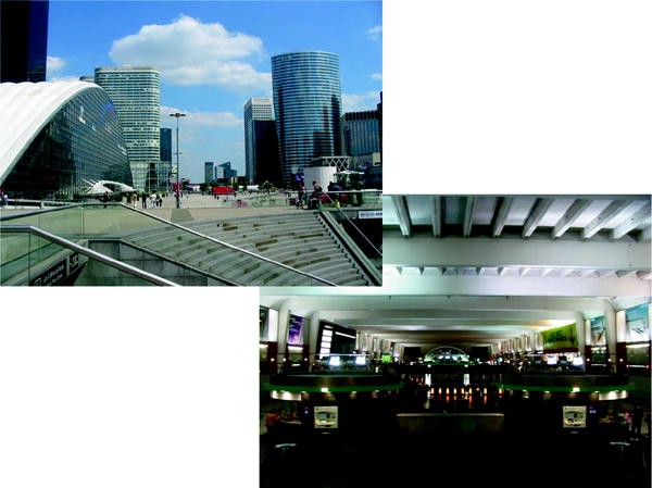
La Défense business centre, West of Paris: buildings over the general slab; below, access hall towards RER A tracks (express metro), regular metro, local trains, tramcars, busses, taxis, car parks and commercial centers
-
existing underground infrastructures (Paris metro improvements);
-
projected underground infrastructure (a connecting station in New Town Marne-la-Vallée, named Descartes-Noisy on Fig. 233.2).

6 Conclusions
The project is an opportunity to add more depth to the city, to reduce urban sprawl, to minimize energy costs by taking advantage of thermal inertia, and to preserve natural spaces (more green in towns). We believe that the underground can be an indispensable partner in the evolution of dense, sustainable and desirable city (Barroca et al. 2014).
It aims at developing an applied multi disciplinary research on the contribution of the underground to urban development and tries to define a new way of planning the use of the subsurface through the interactions between the surface and the subsurface; its ambition is to show that there is a credible alternative to the development of the sole surface: the underground volume is a real resource for a long term sustainable urban development.
It calls for a major geological component, the true reason why it is presented at this conference.
References
Barroca B, Diab Y, Serre D (2014) Penser la ville et agir par le souterrain, ed. Presses des Ponts, Paris (forthcoming)
Brégeon J (1983) L’aménagement du sous-sol Thesis. Marseilles University, France
Duffaut P (1977) Site reservation policies for large underground openings.In: Bergmann M (ed) First international symposium rockstore, Stockholm
Duffaut P, Labbé M (1995) Les réseaux comme germe d’espace souterrain; Tunnels and Ouvrages souterrains, 130, juil.-août, p 255–261
Duffaut P, Labbé M (2002) From underground road traffic to underground urbanism. ACUUS Cong, Turin
Duffaut P (2003) Supply and demand of subsurface space between geo- and law-sciences, 1st International Conference Sustainable development and management of subsurface space, Utrecht, CDROM
Gérard M, Nguyen T (2002) What about Clé de Sol ACUUS International conference of Turin
Groupe de recherche Clé de Sol (2004) Guide pratique des galeries multi réseaux. Territorial, Voiron, p 220
Hénard E (1910) (1st ed 1903–1910; 2nd ed 1982) Études sur les transformations de Paris et autres écrits sur l’urbanisme, ed. Paris, L’Équerre
Le Corbusier (1943) La Charte d’Athènes, Plon, 16:243
Le Nir M, Labbé M, Deffayet M, Duffaut M, Gérard M, Barré MC (2010) Étude de faisabilité du projet national Ville 10D. MEEDOM, p 57
Utudjian É (1952) L’urbanisme souterrain. Presses univ, de France, p 102
Author information
Authors and Affiliations
Corresponding author
Editor information
Editors and Affiliations
Rights and permissions
Copyright information
© 2015 Springer International Publishing Switzerland
About this paper
Cite this paper
Duffaut, P., Labbé, M. (2015). 10 Dimensions Town Planning Research Project. In: Lollino, G., Manconi, A., Guzzetti, F., Culshaw, M., Bobrowsky, P., Luino, F. (eds) Engineering Geology for Society and Territory - Volume 5. Springer, Cham. https://doi.org/10.1007/978-3-319-09048-1_233
Download citation
DOI: https://doi.org/10.1007/978-3-319-09048-1_233
Published:
Publisher Name: Springer, Cham
Print ISBN: 978-3-319-09047-4
Online ISBN: 978-3-319-09048-1
eBook Packages: Earth and Environmental ScienceEarth and Environmental Science (R0)