
Abstract
Coastal karst is a dominant landform within the Caribbean that has played a significant role in shaping human migration and settlement patterns, modern economic development in the region and its evolving biodiversity. Recent exploration of coastal karst, associated models of littoral cave development and comparative coastal resource management strategies are examined in three distinct island settings in the Caribbean: The Republic of Haiti, Grenada and Isla de Mona (Puerto Rico). These regional island examples display distinct and complex coastal karst morphologies ranging from intensely karstic carbonate platforms to complex non-carbonate island cores overlain by extensive and thickly-bedded coastal and interior carbonate cover or predominantly volcanic landscapes with limited fringing carbonates. Previously unreported field research in these selected island settings support an emerging view of the complex karst development in the region and indicate that significant karst areas remain to be explored while illustrating the associated landform vulnerabilities, anthropogenic effects and range of coastal resource management and preservation initiatives applied to date.
Access provided by Autonomous University of Puebla. Download chapter PDF
Keywords
These keywords were added by machine and not by the authors. This process is experimental and the keywords may be updated as the learning algorithm improves.
1 Introduction
The Caribbean Sea defines an area of approximately 2.6 million km2 with over 55,000 km of coastline and more than half of its total associated landmass is predominantly carbonate (Day 2010; Stanley 1995). Similar to the assessment of marine and terrestrial biodiversity in the region (Lutz and Ginsburg 2007; Miloslavich et al. 2010), thorough exploration and study of coastal karst in the Caribbean remains markedly incomplete even though recent research efforts have spurred advances in developing modern models of coastal speleogenesis (Mylroie and Mylroie 2013). Perceptions of the inherent values of coastal karst vary widely and encompass a diverse range of attributes specific to these complex landforms, including geological, biological, cultural and economic resources. Three contrasting case studies serve to illustrate a range of coastal karst management approaches that hinge upon recent exploration, inventory and study of cave and karst development on these geographically and geomorphologically diverse island landscapes (Fig. 6.1). The potential role coastal caves play in shaping sustainable management of coastal zones at risk is also examined in each setting.

Regional study area
Field research applied to all three settings in this communication included the generation of detailed site maps (Lace 2008), associated resource inventories and specific management assessments consistent with karst resource monitoring approaches (Palmer 2007; Toomey 2009). No sampling of geological, biological or cultural materials at any cave sites was conducted as the preliminary site assessments (many reported for the first time) were designed to lay the initial groundwork, within the context of a broader coastal cave and karst database, to support more detailed studies by future researchers in multiple fields.
2 Coastal Karst of the Republic of Haiti: Exploration, Research and Resource Management
The Republic of Haiti (19 00N, 72 25W) is one of the least understood karst areas in the Caribbean. It is one of the most mountainous islands in the region with elevations reaching 2,700 m (asl), encompassing an area of 27,500 km2 (Fig. 6.2). Some of its rugged interior still remains inaccessible other than by foot or pack animal. However, Haiti is one of the most densely populated landmasses in the western hemisphere with approximately 9.5 million inhabitants. Such a population density on a landscape which is estimated to be more than 70 % karst carries stark implications for groundwater quality and clear complications to the dynamic balance between sustainable long-term development and preservation of one of the most fragile and biologically diverse terrains in the region.

(a) Tectonic setting of Hispaniola and the Puerto Rican Islands, where the Gonave (GM), Hispaniola (HM) and Puerto Rico-Virgin Islands (PRVIM) microplates are bounded by the WPGE Walton-Plantain Garden-Enriquillo, NH North Hispaniola and SF Septentrional faults (Adapted from Cotilla 2007) (b) Map of Haiti and associated offshore islands
2.1 Geographic and Geologic Settings
The Republic of Haiti occupies the western third of the Island of Hispaniola and contains 1,800 km of coastline exhibiting a variety of morphologies, including extensive karst areas (Fig. 6.3). Haiti also has several significant offshore islands, most of which exhibit degrees of karst development (Figs. 6.2b and 6.4). Inland karst areas are similarly extensive and complex encompassing a range of lithologies associated with mature epikarst and numerous examples of classical continental cave and karst development. Though periodic geologic studies have been conducted across the island, coastal landforms in Haiti have remained the least studied in the Caribbean (Florentin and Maurasse 1982; Hadden and Minson 2010). Coastal geomorphologies include well-developed embayments, estuaries, extensive coastal plains and cliffs as well as some of the best-preserved uplifted Pleistocene-aged terraces in the region (Dodge et al. 1983) (Fig. 6.5). Recent systematic survey efforts, in collaboration with the Haitian Speleological Survey, designed to document the coastal karst resources have revealed a complex inventory of cave types shaped and repeatedly modified by a range of coastal and continental karst processes coupled with changing sea levels within one of the most dynamic tectonic regimes in the Caribbean (Cotilla et al. 2007; Mann et al. 1991) (Fig. 6.2a).

Coastal geomorphologies in Haiti. Embayments and cave development on the (a) north coast and (b) south coast of the southern peninsula. (c) Karstic Pleistocene-aged coastline in the Gulf of Gonave. (d) Cave and arch development (Jeremie area) and (e) beach development on the coastal plain, southern Peninsula

Coastal karst examples from Ile a Vache, Haiti. (a, b) Sea cave in Abaka Bay. (c, d) offshore karst pinnacle exhibiting remnant of flank margin cave development

Complex network of uplifted Pleistocene reef terraces, Northern Peninsula, Haiti

Karstic coastal barrier estuary (Labaye, southern Peninsula)
2.2 Cave and Karst Development
Beginning in 2007, detailed field exploration and study of Haiti’s caves and karst areas has been conducted by Haitian and American participants as part of an ongoing collaborative effort between private landowners, university and community leaders, and government ministries on a countrywide scale. Over 250 karst and pseudokarst caves have been recorded to date. Karst cave examples include fluvial caves, flank margin caves (formed by mixing zone dissolution), Pseudokarst cave examples in Haiti include tufa caves (i.e., constructional caves formed by rapid carbonate deposition), sea caves (erosional structures formed by wave energy) fissures, talus caves (cavities within rock collapse), man-made caves (from limestone quarrying) and tafoni (cavities formed by salt air weathering). Grotte Marie-Jeanne (Port-a-Piment) is currently the largest surveyed cave in Haiti, defined by 5 km of passage reaching a maximum depth of 102 m within a coastal ridge (Figs. 6.7 and 6.9), yet the potential for the discovery of more extensive caves remains.

Grotte Marie-Jeanne, Port-a’-Piment, Haiti (a) proposed trail map. (b) Principal doline entrance and tour route (photo by Brian D. Oakes)

Coastal land use panel (a) quarrying (b) fishing (c) deforestation and (d) slope instability and associated agricultural land use

Lac Sourel – lower level of Grotte Marie-Jeanne
Significant exploration and documentation is required to define the clearly complex patterns of littoral and continental karst expression. While a comprehensive model of coastal cave and karst development in Haiti is still under construction, preliminary data demonstrates that field research in these complex and stunning littoral landscapes has enormous potential to contribute to a modern collective understanding of karst mechanisms in the Caribbean with direct implications to emerging long-term coastal preservation strategies.
2.3 Coastal Resource Management: Opportunities and Potential Pitfalls
Long-term anthropogenic impacts to interior and coastal ecosystems in Haiti have been significant and continue to present formidable challenges to resource management. Though significant coastal environments still remain intact, in many coastal zones population densities coupled with limited infrastructure development placesignificant pressures on coastal resources, the effects of which are manifested in a variety of forms (E.I. 2012). Coastal land uses include: agriculture on varying scales, logging, fishing, salt production, mining (primarily limestone for construction) and infrastructure and housing development, with a limited tourism component to date (Fig. 6.8). However, not all projected large-scale tourism development appears to be consistent with models of sustainable management of natural coastal settings and preservation of both natural and cultural resources – a pattern that persists in many insular and continental coastlines worldwide.
2.3.1 Landscape Vulnerabilities and Coastal Watershed Management
Coastal areas in Haiti feature complex geomorphologies and equally complex management issues. While integrated coastal resource management approaches have seen limited success elsewhere in the Caribbean, they have yet to be widely applied to the karstic shorelines of Haiti. Thus, both longstanding and emerging land use issues continue to negatively impact landform stabilities, water availability/quality, economic development and resource preservation on a large scale.
Water quality and availability are persistent issues in coastal communities with karst areas prone to aquifer contamination (Lace and Mylroie 2013; Wampler and Sisson 2011). Watershed resources vary widely across the current as a function of its complex hydrogeology (Troester and Turvey 2004; USACE 1999). Significant karstic estuaries are used a primary water sources, for example in the southern peninsula community of Labaye (Fig. 6.6). Storm event vulnerabilities are also apparent with flooding effects to infrastructure, habitation, agriculture and more importantly recurrent loss of lives in coastal communities during hurricane events. Tectonic hazards (earthquakes, tsunami, terrestrial landslides) also pose significant collapse risks in coastal karst zones (Pikelj and Juracic 2013).
Such vulnerabilities of karst landscapes in this area of the Caribbean are not unique to Haiti, for example, nearby Jamaica (two thirds of which is karstic terrain) is subject to the same risks of expanding anthropogenic influences (Day 2007). The accompanying case studies similarly illustrate the range of landform vulnerabilities in the region and contrasting sustainable management models. Recent coastal management initiatives also include the designation of the first Marine Protected Area in Haiti in 2013, encompassing a southwestern coastal zone associated with the mainland shore areas of Port Salut/Aquin as well as the offshore island of Ile a Vache (Fig. 6.2).
2.3.2 Cultural Resource Preservation and Haitian Karst
Archeology in the Caribbean is a complex and dynamic field of research, linking multiple cultural periods with diverse physical landscapes (Wilson 2007). Hispaniola occupies a pivotal position in regional models of cultural evolution but sporadic fieldwork has only begun to document the extent of cultural resources in Haiti (Rouse and Moore 1985). Preservation of cultural heritage in the Caribbean has seen renewed interest in recent years (Siegel and Righter 2011), yet the Republic of Haiti has been conspicuously absent in such discussions even though its rich cultural resources derived from its archaic, historical and modern periods, stand at significant immediate and long-term risk.
Geotourism has emerged as an expanding development pattern on a global scale, carrying with it controversial incumbent risks to resource preservation frequently at odds with the benefits of economic growth (Dowling 2011). As in any karst setting, a delicate balance must be struck between access to the resource and the incumbent impacts of varying degrees of development and visitation. In Haiti’s southern peninsula, for example, a sustainable regional ecotourism plan can be further developed using the initial community-based development of Grotte Marie-Jeanne as a focal point for a selection of area destinations, as demonstrated in other settings (Pavlovich 2002; Timcak et al. 2010).
Grotte Marie-Jeanne (Port-a-Piment) presents an intriguing test case for sustainable eco-tourism development in the southern peninsula that is applicable to other karst settings across Haiti. Consistent with community-based approaches applied elsewhere (Hobbs 2004), integration of a broad a cross-section of the local populace both in development and long term management phases of the Grotte Marie-Jeanne project potentially enhances local economic growth while increasing community investment in the long term preservation of the resource. Consistent with initial assessments of the potential for the project (Kambesis et al. 2010), recent developments include improved access to the cave, construction of an interpretive center, development of a low-impact trail within the accessible entry segment of the cave system (Fig. 6.7) and a management plan supporting limited tours by trained local guides and appropriate safety equipment. The project involves support from the community of Port-a-Piment, the UNEP and the Haitian Ministry of Tourism. As a direct result of detailed resource assessments and recently implemented improvements, the land above the cave has now been designated a protected area, which will ideally promote long-term reforestation plans to enhance area biodiversity and promote slope stabilization of the ridge harboring Grotte Marie-Jeanne and associated caves. Grotte Marie-Jeanne forms an integral part of a long range stewardship plan consistent with current karst resource management approaches (Cigna 1993; Jones et al. 2003; Kambesis et al. 2013) and previously proposed resource management initiatives in Haiti (Woods and Harris 1986).
At present, Grotte Marie-Jeanne remains unique in its sustainable site development strategy compared to the limited number of publicly accessible caves in Haiti, some of which have seen significant negative impacts from poorly structured visitation and vandalism. Clearly, not every cave site (coastal or inland) is suitable for ecotourism and detailed site assessments prior to any development planning must be carefully considered.
3 Modeling Cave Development Patterns on Isla de Mona, Puerto Rico
3.1 Geologic and Geographic Setting
Located 68 km west of Puerto Rico (18 05N, 67 53W), Isla de Mona (58 km2) and adjacent Isla Monito (0.17 km2) are emergent surfaces of an uplifted carbonate block within the tectonically active Mona Passage (Fig. 6.1). The island platform rests on the Hispaniola-Puerto Rico Microplate within the complex continental margin defined by the North American Plate to the north and the Caribbean Plate to the south (Mann et al. 1991) (Fig. 6.2a). Isla de Mona is bounded by deep rift structures within a dynamic submerged landscape marked by periodic structural modification (i.e., linear extension) driven by strike-slip plate motion. The Mona coastline (32 km in length) is overwhelmingly karstic yet evidence of karst development associated with the platform is not confined to the emergent surfaces as a limited selection of submerged cave and karst features have also been mapped (Fig. 6.10).

(a) Map of Isla de Mona with regional inset (Benthic profile adapted from Kaye 1957). (b) Playa Sardinera, west coast of Isla de Mona. (c) Karstic cliffline, east coast of Isla Mona
Isla de Mona is Mio-Pliocene aged platform composed of two primary carbonate units. The volumetrically predominant platform base is composed of Mona Dolomite while the Lirio limestone forms a surface layer of limited vertical extent. The karst and pseudokarst landscapes of Isla de Mona provide an enduring record of episodic void development as a function of repeated sea level fluctuations and long term tectonic uplift. The predominant expressions of cave development are dissolutional voids formed within the flank of the landmass by processes associated with the margins of freshwater lens (i.e. flank margin caves), as defined by Mylroie (2013) and discussed in the next section.
3.2 Cave and Karst Development
Over 200 coastal caves have been documented on the island to date (Lace 2013), the majority of this inventory is composed of flank margin caves, including the largest known flank margin cave in the world – Sistema Faro (Lace et al. 2014), but also includes sea caves, pit caves and talus caves. Detailed cartography and analysis of the structural morphologies of these karst and pseudokarst expressions support a complex model of carbonate island cave development as a function of tectonic uplift, sea level changes, karst hydrogeology and cliff retreat (Fig. 6.11).

Map – Cueva Capitan, example of complex cave development within the Isla de Mona shoreline

Coastal denudation model. Progressive structural evolution of a flank margin cave (a–d) and sea cave (e–h) in a littoral environment
3.3 Karst Exploration and Research
Cave surveys and inventories formed the critical baseline database to which multiple analyses were applied, as previously reported (Lace 2008). Cave distribution analyses provide an overview of cave development trends in terms of lithology of the host rock and specific cave type (as an end proxy for tracking primary speleogenetic processes) (Fig. 6.13a, b). Yet more detailed approaches were necessary to quantitatively define the karst morphologies within the inventory and model their associated mechanisms of development.

Cave distributions by (a) lithology and (b) cave type. (c, d) Modeling cave morphologies on Isla de Mona, where D fractal dimension, EW cave entrance width and IW internal passage width
3.3.1 Denudation Mechanisms
The coastal environment of Isla Mona is a geologically dynamic zone, with continual modification by cliff retreat, driven by energetic wave energy and progressive structural failure of its karstic escarpments. Though the estimated extent of cliff retreat is limited compared to other island settings, it has profoundly altered the majority of cave expressions on the island which are associated with the platform periphery. Figure 6.12 illustrates that coastal denudation mechanisms act in a similar manner on contrasting coastal cave structures. Flank margin caves are preexisting voids that are subsequently breached, exposed and denuded by littoral processes (Fig. 6.12a–d). In contrast, sea caves are initially formed by the same littoral processes that subsequently modify the erosional void (Fig. 6.12e–h), potentially resulting in a common endpoint structure (Fig. 6.12h).
3.3.2 Fractal Analysis of Coastal Cave Morphologies
Fractal geometry has long been used to mathematically define complex natural structures with particular attention to varied coastal landscapes and modeling the effects of a range of coastal processes (Tanner et al. 2006; Schwimmer 2008). Fractal analysis has previously been applied to a range of karst structures, from fluvial origins (i.e. stream cave networks) to paleokarst and fracture networks in a variety of landscapes (Kusumayudha et al. 2000; Skoglund and Lauritzen 2010; Robledo et al. 2002; Ferer et al. 2013). In contrast to the limitations associated with traditional methods of cave measurement, i.e. applying Euclidian algorithms to “fractal” objects (in this case – cave structures), fractal analyses can offer a more sophisticated approach to defining the distinctive, complex morphologies observed in karst (Curl 1986; Laverty 1987).
In terms of analyzing coastal karst expressions, this potential is underscored as measurements of total cave length, long applied to cave morphologies in traditional settings (Ford and Ewers 1978), have proven of limited value in coastal settings where caves are often complex, non-linear structures (Mylroie 2007). Thus, coastal caves which are morphologically complex represent prime candidates for such analyses. Similar to other karst features in carbonate coastal settings, the caves of Isla de Mona are clearly “fractal” objects (Fig. 6.13c). Fractal objects, whether theoretical constructs or shapes occurring on nature, exhibit a range of fractal dimensions, typically expressed within a range of 1.0 and 2.0. The fractal dimension (D) of a given object can be calculated using a variety of methods, where N is the number of spatial increments (i.e. boxes) required to define the shape and C is the scale (i.e., box size) applied. The fractal box count (D) is then determined from the negative slope of the regression line derived from the plot of the log of the box count versus the log of the box size (Fig. 6.13d).
The flank margin caves of Isla de Mona and many other coastal settings display limited vertical passage development – consistent with their model of genesis and in stark comparison to other continental karst expressions (Palmer 1991; Mylroie 2013). In this island setting, they are comparatively planar structures which generally feature limited vertical extent compared to lateral passage development, as defined by total cave perimeter and total aerial footprint (or total “cave area”). Thus, two-dimensional data, as depicted in detailed cave maps (Fig. 6.11), can serve as an adequate proxy for morphological complexity in this case, where tectonic uplift in conjunction with sea level fluctuations have not conspired to generate multiple elevations of elaborate passage development within a single cave.
Figure 6.14 graphically compares each Mona cave to multiple spatial (morphometric) parameters: (i) aerial footprint (i.e “total cave area”), (ii) relative degree of structural denudation, based on maximum entrance width to maximum internal passage width ratio (Fig. 6.13e), and finally (iii) fractal dimension (as determined by a standard fractal box count described above). The average fractal dimension [D = 1.84 ± .05] for the cave data set from Isla de Mona was measured from sample of over 140 documented cave sites, exhibiting a narrow dimensional range of 1.63–1.94 and encompassing examples of all recorded karst and pseudokarst cave types, cave areas (11–28,072 m2) and measured effects of denudation (0.13 to a theoretical maximum of 1.0, as per Stafford et al. 2004). The fractal dimension range of the cave data set is persistent throughout, serving as a continuous morphological thread, as it were. Interestingly, though the cave sites examined have been exposed to a range of coastal modification and denudation effects due to repeated cycles of coastal modification, cave formation and cliff retreat, the fractal profile indicates that the overall complex morphologies of these structures have been retained through a span of profound episodic patterns of coastal landscape evolution.

Spatial analysis of Mona caves, using Image J software analysis of cave maps (National Institutes of Health, Bethesda, MD, www.NIH.gov); where tc talus cave, sc sea cave and I indeterminate
Though the sample size is sufficiently large, the range of cave types within the cave inventory is limited in that flank margin caves represent the predominant form of coastal cave expression on the island, with a minority segment composed of pseudokarst cave types. Thus, the overall morphology would be expected to be similar (as Fig. 6.14 indicates) and consistent with karst development within the theoretical framework of a simple carbonate island setting within the Carbonate Island Karst Model (CIKM) (Mylroie and Mylroie 2007). Figure 6.14 further demonstrates that flank margin caves compose the majority of the recorded cave area (or degree of void development) and subsequently can be identified as the principal potential instability component (i.e. recorded void type) in an overall coastal karst landform stability profile of Isla de Mona.
Expanding the morphological comparison of the Isla de Mona cave data to other island karst settings that display greater diversity in observed cave types and island platform complexity may prove useful in delineating regional trends in coastal speleogenesis, biodiversity and landform stabilities. Nevertheless, the comparison of multiple spatial criteria that specify cave and karst morphologies, as shown here, provides a comparative morphometric profile of cave development on Isla de Mona that spans the measured extent and diversity of these resources – an approach that can readily be applied to other settings.
Previous analyses using morphometric parameters to better define cave patterns in coastal settings have shown promise but greater quantitative definition is still needed to differentiate cave and karst structures based on their distinctive morphologies (Basso et al. 2012; Owen 2013; Lace 2008; Waterstrat et al. 2010). Inclusion of additional fractal indices, such as lacunarity or tortuosity (i.e. generating a multi-fractal profile) may prove useful in future expanded studies by further discriminating between structures based on speleogenic origins in this or other coastal settings. Three-dimensional modeling of cave structures has shown considerable promise but such analyses have yet to be applied to a sufficiently broad sampling of both coastal and continental karst landscapes to permit discrimination of type-specific cave morphologies (Boggus and Crawfis 2007; Kincaid 1999; Pardo-Iguzquiza et al. 2011; Labourdette et al. 2007). As demonstrated in this chapter, simultaneous analysis of multiple spatial parameters specific to coastal karst may reveal previously undefined patterns, potentially contributing to a better understanding of coastal cave development, karst landform stability profiles and the distribution of critical cave habitats in coastal environments.
3.4 Cave and Karst Resource Management
The coastal karst of Isla de Mona is considered world class in terms of its density, scale and complexity. As a natural reserve (designated by the U.S. Dept, of the Interior in 1975) and part of the largest marine protected area in the Puerto Rican islands, the island and its resources have remained largely untouched by expanding commercial and residential development that has at times inflicted profound impact on coastal landforms on the Puerto Rican mainland. As a U.S. territory, Isla de Mona is considered a U.S. border, thus a coast guard and terrestrial border security presence is a key component of its routine management operations. Geographically, the island continues to occupy a pivotal position in the western Caribbean as a U.S. border control point refugees, many in small vessels of questionable seaworthiness, periodically make landfall on the Mona coast.
In addition to the unique geology and biologic diversity, the caves also reflect a complex human history associated with the island and its resources, spanning archaic occupation (4,300 ybp) through Euro-colonial expansion to present day karst preservation efforts within the context of a natural reserve. Recent field research has revealed that the caves of Isla de Mona offer a unique glimpse into archaic and historical periods associated with the complex role Isla de Mona has played in shaping cultural progression in the Puerto Rican islands and in the broader region (Dávila 2003; Lace 2012; Rodriguez Ramos 2010) (Fig. 6.15). This unique geoarcheological profile carries distinct cultural resource management requirements.

(a) Cave rock art on Isla Mona. (b) Remnants of nineteenth century guano mining
Isla de Mona continues to offer a unique carbonate island setting in which field research in coastal speleogenesis, tropical cave climate modeling, island karst biodiversity and geoarcheology of caves in the Caribbean region can be conducted. All research on Isla de Mona is performed via a permit system administered by the Puerto Rico Department of Natural Resources (Departamento Recursos Naturales y Ambientales de Puerto Rico). Though we have collectively learned a great deal about the geological, biological and cultural significance of the many caves and karst features on Isla de Mona to date, significant research in many disciplines remains to be accomplished. Field research continues on Isla de Mona with the goal of completing the cave and karst inventory as a critical baseline tool for future studies and for supporting long term preservation and management goals.
4 Coastal Caves of Grenada
4.1 Geologic Setting
The island of Grenada occupies the southernmost position in the Lesser Antilles island chain (12 07N, 61 40W), where the pre-Miocene and post-Miocene arcs of volcanic islands converge, >150 km north of Trinidad, Tobago and the South American coast (Fig. 6.1). The island rests on the eastern edge of the Caribbean Plate in a subduction zone with the underlying South American Plate. It is bounded by the Grenada Basin the west and the Tobago Basin to the east. The emergent island platform has a total area of 344 km2 with 121 km of coastline. Geologically the island is composed of complex pyroclastic flows, igneous rock (including andesite domes) and significant areas of reworked volcanic detritus with only isolated fringing carbonate deposits in the form of uplifted reef relicts of Pleistocene age (Arculus 1976). The oldest rock is composed of sedimentary deposits called the Tufton Hall Formation, placing the age of the island within the Eocene to lower Miocene periods. No contemporary volcanic activity has been recorded on the island, with the exception of minor geothermal features in the form of hot springs, there is one active submarine volcano off the northwest coast (Kick’em Jenny) whose last eruption was reported in 1974. Inland morphologies include relict volcanic craters, deep ravines, numerous rivers and volcanic peaks reaching a maximum elevation of 840 m, with comparable elevations supporting a perennial orographic effect and accompanying diverse landcover development.
Coastal morphologies are diverse, featuring arid to heavily vegetated slopes, rocky headlands, cliffs, sea stacks, arches, wave-cut benches, deep embayments, beaches and numerous smaller offshore islands composed of varying lithologies (Fig. 6.16). Caves are also prominent features of the Grenada coast. From a geoarcheological, ecological and hydrogeological perspectives, the inland and coastal landforms on this and other small islands are intimately interconnected (Benz 2010).

Coastal landscapes of Grenada. (a) Coastal outcrop composed of reworked volcanics. (b) One of several offshore islands (Ile Marquis). (c) Shoreline terrace. (d )Active coastal quarry. (e )Sea cliff (Canoe Bay, south coast). (f) Sea arch development
4.2 Cave Development
Though carbonate coastal landforms are dominant in the Greater Antilles, non-carbonate coastlines are prevalent in the Lesser Antilles Arc and must also be considered when comparing regional coastal zone management approaches as a function of the cultural resources and overall biodiversity unique to such settings. Grenada features minimal carbonate exposures therefore limited potential for true karst development in its coastal settings. Yet, coastal zone management strategies are not limited solely to carbonate landforms. Pseudokarst examples are confined to coastal areas and found in varying locations across the island in developed, undeveloped zones and MPAs (Fig. 6.17). No submerged caves have been recorded of the coast of Grenada with the exception of anecdotal reports from divers of submerged caves off the coast of nearby Carriacou. Though caves in Grenada play important roles in the cultural history and biodiversity, they had previously been poorly defined. This report offers the first formal report of pseudokarst development on Grenada.

Pseudokarst examples: (a) Ft. Jeudy cave (b) St. David’s bat cave (c) Lover’s Bay cave. (d) Sea cave formed within Pleistocene-aged limestone, north coast
A total of 41 caves have been documented on the island to date though exploration of all coastal areas and submerged areas in the nearby Grenadine islands remains incomplete. All of the caves defined on Grenada are pseudokarst, or not formed by karstic dissolution processes, encompassing varied expressions of sea cave development (Moore 1954) primarily within contemporary shorelines composed of reworked volcanics with a minority located within uplifted coastal basalt and Pleistocene-aged limestone. The following examples serve to illustrate this pattern:
-
Black Sand Punchbowl (Fig. 6.18). Three separate entrances breach the coastal outcrop of reworked volcanics, leading to an amphitheater-like, open-air chamber laterally connected to the sea. The structure resembles a littoral sink (commonly referred to as a “punchbowl”) similar to numerous examples recorded on the western U.S. coast (Bunnell and Kovarik 2013) (Fig. 6.18a, b). Continual wave energy has been focused on structural defects in the coastal exposure, resulting in progressive cavity development and eventual collapse of limited overburden to generate the structure observed today (Fig. 6.19a). A second site to the east of the punchbowl likely represents a remnant structure formed by similar processes, with only a partial perimeter segment remaining as a natural bridge (Fig. 6.18c). If it were in a carbonate coastal setting, however, a karstic model of structural genesis would invoke a different interpretation as a breached flank margin cave, that is, a preexisting cavity initially formed by dissolution processes associated with a freshwater lens, as discussed in the section on Isla de Mona and documented in many other carbonate island settings (Mylroie 2013). While limestone exposures are restricted to the northern end of the island – no flank margin caves have been identified. Such a dissolutional model is not tenable in the majority of the coastal settings on the island given the porosity and structural integrity associated with reworked coastal volcanics and basalts.
Fig. 6.18 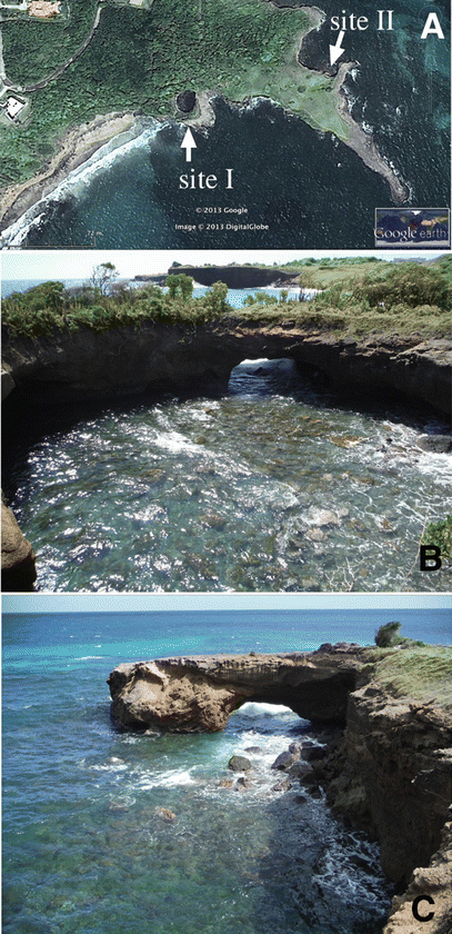
Littoral sinks. (a) Aerial image of pseudokarst features within the Grenada coastline (Courtesy of GoogleEarth). Sites I and II indicate similar features at different stages of development. (b) Black Sand Punchbowl (Site I) and (c) Natural Bridge (site II)
Fig. 6.19 
(a) Map of Black Sand Punchbowl. (b) Map of Trou Mais, Grenada
-
Trou Mais (Fig. 6.19b) is the longest recorded cave on Grenada with 37 m of surveyed passage formed within a Pliocene-aged basalt flow (Fig. 6.20). The cave has been reported as entirely man-made but close inspection revealed that this is not the case. Located at ~30 m asl and proximal to the current shoreline, the structure is most likely a sea cave formed by previous sea level stillstand. The structure was subsequently uplifted to its current position, which is comparable to maximum elevations associated with uplifted Pleistocene-aged limestones on the northern end of the island (Arculus 1976). The cave is an important pre-contact cultural site, exhibiting anthropogenic passage modification consistent with its reported pre-Columbian use as agricultural storage (i.e. corn) by the Caribs (hence the cave name). The cave is also a significant bat habitat, hosting multiple species, as well as a range of opportunistic species including anole and frogs. Modern anthropogenic site uses include minimal tourist visitation, including occasional local school fieldtrips, and sporadic, non -commercial harvesting of guano as a garden fertilizer.
Fig. 6.20 
Trou Mais. (a) Main entrance. (b) Internal passage cross section. (c) Anterior opening. (d) Excavated side passage and (e) roosting bat
-
St. David’s Bat Cave. Two entrances lead into a large sea cave chamber that passes 15 m through a narrow coastal ridge (Fig. 6.17b). It is the most significant cave bat roost identified on the island to date with more than several hundred occupants and clear signs of long term bat use. As such, the site warrants long-term colony monitoring and immediate proactive preservation efforts.


The remainder of the cave inventory features variations of sea cave expressions as well as man-made cavities. Not surprisingly, the majority of sea cave development is associated with embayments exposed to the prevailing currents which flow westward through the Grenada Passage, supplying a significant amount of the inflow into the Caribbean Sea. Embayments and associated peninsulas of varying scales focus the wave energy associated with these currents onto structural defects within littoral exposures of volcanics, resulting in erosional void development.
4.3 Coastal Geoarcheology
The pre-Columbian cultural sequence of Grenada spans pre-Arawak, Arawak and Carib occupation, partly based on surface excavations across the island (Bullen 1965). At least five rock art sites also attest to past cultural use of both coastal and inland landscapes – all associated with non-carbonate boulders locally known as “Carib Stones”, for example, at Duquesne Bay (Fig. 6.21a, b). At least four other coastal and inland rock art sites have been reported on the island (Fig. 6.21c, d) (Cody 1990; Marquet 2002). Rock art examples on Grenada range from simplistic to elaborate anthropomorphic, zoomorphic and geometric forms and are thought to date to the late pre-contact period (900-1400 B.C.), though no confirming dating technique has been applied to date. Prior efforts to apply UNESCO heritage status to one of these sites have so far been unsuccessful. All documented rock art sites currently remain at risk, displaying a range of rock surface instabilities and land use pressures (Allen and Groom 2013). The only cave exhibiting pre-contact use (consistent with site ethnography) is Trou Mais (Fig. 6.19d), as previously discussed. Excavations at a coastal site adjacent to the cave yielded ceramics dating to A.D. 1-300. Such coastal cultural sites must be an integral component of a long-term preservation plan that has yet to be fully implemented – a recurrent trend in the region and a common denominator present in all three settings described in this report.

Rock art of Grenada. (a–c) Coastal sites (d) interior river site (note 10 cm scale)
4.4 Coastal Cave and Karst Resource Management
Grenada has a population of over 100,000 with an economy based primarily on tourism, agriculture and local industries as reflected in land use patterns across the island (Ternan et al. 1989). Coastal areas figure prominently in this economic model. Management strategies have been enacted to both support local economic viability and resource preservation with the context of sustainable models (Thomas 2000; UNEP 2012; Watson 2007), utilizing integrated GIS methods to define the complex coastal resources at risk (DeGraff and Baldwin 2013; Helmar et al. 2008). The caves of Grenada and adjacent insular environments also feature substantial biodiversity associated with coastal and interior landscapes (Pederson et al. 2013). However, cave development is limited compared to other islands in the Lesser Antilles and are not prominent components of existing tourism destination models or coastal zone management plans. Though environmentalism is well-developed on the island, spanning community and governmental levels, commercial land use pressures still pose a significant risk to coastal landform integrity (Fig. 6.16d).
5 Summary
Coastal karst and pseudokarst form one of the dominant emergent landscapes in the Caribbean. As the preceding examples demonstrate, exploration and study of these diverse landscapes is still far from complete. Haiti, Isla de Mona and Grenada feature contrasting coastal geomorphologies which have directly influenced the diversity and degree of coastal cave development. This has further influenced endemic biodiversity (Willig,et al. 2010) and patterns of human settlement and cultural uses of coastal landscapes from Archaic through modern periods (Fitzpatrick and Keegan 2007). Yet, all three settings share the same imperative and general strategies to preserve and effectively manage these natural and cultural landscapes. A more comprehensive understanding of cave and karst development patterns in these and other coastal settings has multi-disciplinary implications, supporting management of at-risk karst resources, with the potential to influence the quality of life of significant coastal populations throughout the region. In depth field exploration remains a critical component of this process. Integrated analysis of the geological, biological and geoarcheological significance of coastal caves and karst offers critical perspectives to emerging models of both physical and cultural landscape evolution not only on a regional scale but with broader applications as well.
References
Allen CD, Groom KM (2013) Evaluation of Grenada’s “Carib Stones” via the rock art stability index. Appl Geogr 42:165–175
Arculus RJ (1976) Geology and geochemistry of the Alkali Basalt – Andesite Association of Grenada and the Lesser Antilles Island Arc. Geol Soc Am Bull 87(4):612–624
Basso A, Bruno E, Parise M, Pepe M (2012) Morphometric analysis of sinkholes in a Karst coastal area. Geophysical research abstracts, vol 14. EGU General Assembly
Benz EJ (2010) A Paleoenvironmental reconstruction from the Island of Grenada, Caribbean environments through the time of human occupation. MA thesis, Department of Anthropology, Washington State University, 94p
Boggus M, Crawfis R (2009) Procedural creation of 3D solutional cave model. Proceedings of the 20th IASTED International Conference on Modeling Simulation. Banff, Alberta, pp 180–186
Bullen RP (1965) An archaeological chronology for Grenada. Am Antiq 31(2):237–241
Bunnell DA, Kovarik JL (2013) Caves of the Western U.S. coast. In: Lace MJ, Mylroie JE (eds) Coastal karst landforms, vol 5, Coastal research library series. Springer, Dordrecht, pp 299–316
Cigna AA (1993) The environmental management of tourist caves: the examples of Grotta di Castellano and Grotte Granda del Vento, Italy. Environ Geol 21:173–180
Cody A (1990) Faces and figures on Grenada: their historical and cultural relations. In: Rock art papers, vol. 7, San Diego Museum of Man, San Diego
Cotilla MO, Cordoba D, Calzadilla M (2007) Morphotectonic study of Hispaniola. Geotectonics 41(5):368–391
Curl RL (1986) Fractal dimensions and geometries of caves. Mar Geol 18(8):765–783
Dávila O (2003) Arqueología de la Isla de la Mona. Editorial del Instituto de Cultura Puertorriqueña, San Juan
Day M (2007) Natural and anthropogenic hazards in the Karst of Jamaica. Geol Soc Lond Spec Publ 279:173–184
Day M (2010) Human interaction with Caribbean karst landscapes: past, present and future. Acta Carsologica 39(1):137–146
DeGraff AK, Baldwin K (2013) Participatory mapping of heritage sites in the Grenadines. CEMRES technical report no. 65. Centre for Resource Management and Environmental Studies, Barbados
Dodge RE, Fairbanks RG, Benninger LK, Maurasse F (1983) Pleistocene sea levels from raised coral reefs of Haiti. Science 219(4591):1423–1425
Dowling RK (2011) Geotourism’s global growth. Glob Herit 3(1):1–13
EI (2012) Integrated baseline study: Port-a-Piment watershed, Sud Department, Haiti. Report compiled, in cooperation with the Cote Sud Initiative, by the Earth Institute, Columbia University, New York, 26p
Ferer MV, Smith DH, Lace MJ (2013) Fracture networks from a deterministic physical model as “forerunners” of maze caves (Abstract). In: Proceedings of the AGU Fall meeting, San Francisco
Fitzpatrick SM, Keegan WF (2007) Human impacts and adaptations in the Caribbean islands: an historical ecology approach. Earth Environ Sci Trans Royal Soc Edinb 98:29–45
Florentin JM, Maurasse R (1982) Survey of the geology of Haiti: a guide to field excursions in Haiti. Miami Geological Society, Miami, 103p
Ford DC, Ewers RO (1978) The development of limestone cave systems in the dimensions of length and depth. Can J Earth Sci 15:783–1798
Hadden RL, Minson SG (2010) The geology of Haiti: an annotated bibliography of Haiti’s geology, geography and earth science. USACE Army Geospatial Center, Alexandria, VA, 254p
Helmar EH, Kennaway TA, Pedreros DH, Clark ML, Marcano-Vega H, Tieszen LL, Ruzycki TR, Schill SR, Sean Carrington CM (2008) Land cover and forest formations distribution on St. Kitt’s, Nevis, St Eustatius, Grenada and Barbados from decision tree classification of cloud-cleared satellite imagery. Caribb J Sci 44(2):175–198
Hobbs JJ (2004) Guidelines for the participation of local and indigenous peoples in Karst conservation and management. In: Batelaan O, Dusar M, Masschelein J, Thanh Tam Vu, Tran Tan Van, Nguyen Xuan Khien (eds) Proceedings of the interdisciplinary conference on development and conservation of Karst Regions, Hanoi, Vietnam. Trans-KARST 2004, pp 86–87
Jones WK, Hobbs HH, Wicks CW, Currie RR, Hose LD, Kerbo RC, Goodbar JR, Trout J (2003) Recommendations and guidelines for managing caves on protected lands. Prepared for the National Cave and Karst Research Institute, National Park Service. Karst Waters Institute Special Publication, no. 8, 81p
Kambesis PN, Lace MJ, Despain J, Goodbar J (2010) Assessment of Grotte Marie-Jeanne, Port-a-Piment, Republique D’Haiti. Final report submitted to the Haitian Ministry of Tourism. Available www.grottemariejeanne.com, 40 p
Kambesis PN, Oakes B, Lace MJ (2013) Challenges of cave management in a developing country: a case study of Grotte Marie-Jeanne, Departmente Sud, Haiti. Proceedings of the 20th National Cave and Karst Management symposium, Carlsbad, NM, pp 143–146
Kincaid TR (1999) Volumetric fractal dimension as a quantitative descriptor of saturated cave morphology. In: Palmer AN, Palmer MV, Sasowski ID (eds) Karst modeling. Karst Waters Institute, Charlottesville, p 186 (Abstract)
Kusumayudha SB, Zen MT, Notosiswoyo S, Gautama RS (2000) Fractal analysis of the Oyo River, cave systems, and topography of the Gunungsewu Karst area. Hydrogeol J 8(3):271–278
Labourdette R, Lascu I, Mylroie JE, Roth M (2007) Process-like modeling of flank margin caves: from genesis to burial evolution. J Sediment Res 77:965–979
Lace MJ (2008) Coastal cave development in Puerto Rico. J Coast Res 24(2):508–518
Lace MJ (2012) Anthropogenic use, modification and preservation of coastal caves in Puerto Rico. J Island Coast Archaeol 7:378–403
Lace MJ (2013) Coastal caves and karst of the Puerto Rican islands. In: Lace MJ, Mylroie JE (eds) Coastal karst landforms, vol 5, Coastal research library series. Springer, Dordrecht, pp 207–226
Lace MJ, Mylroie JE (2013) Coastal cave and karst resource management. In: Lace MJ, Mylroie JE (eds) Coastal karst landforms, vol 5, Coastal research library series. Springer, Dordrecht, pp 127–143
Lace MJ, Kambesis PN, Mylroie JE (2014) Sistema Faro: evolution of the world’s longest flank margin cave. In: Robledo PA, Duran JJ (eds) Large cave systems of the world. Boletin Geologico y Minero. Journal of Earth Sciences, Instituto Geologico y Minero de Espana. (in press)
Laverty M (1987) Fractals in karst. Earth Surf Proc Land 12:475–480
Lutz SJ, Ginsberg RN (2007) The state of deep coral ecosystems of the United States Caribbean region: Puerto Rico and the U.S. virgin islands. In: Bumsden SE, Hourigan TF, Bruckner AW, Dorr G (eds) The state of the deep coral ecosystems of the United States. NOAA Technical Memorandum CRCP-3, Silver Springs
Mann P, Draper G, Lewis JF (1991) An overview of the geologic and tectonic development of Hispaniola. Geol Soc Am Spec Pap 262:1–28
Marquet SJ (2002) Les Pétroglyphes des Petites Antilles Méridionales. Contextes Physique et Culturel. Paris monographs in American archaeology. BAR international series 1051, Archaeopress, Oxford. 371p
Miloslavich P, Diaz JM, Klein E, Avarado JJ, Diaz C (2010) Marine biodiversity in the Caribbean: regional estimates and distribution patterns. PLoS ONE 5(8):e11916
Moore DG (1954) Origin and development of sea caves. Nat Speleol Soc Bull 16:71–76
Mylroie JE (2007) Cave surveys, cave size and Flank margin caves. Compass Tape 17(4):8–16
Mylroie JE (2013) Coastal karst development in carbonate rocks. In: Lace MJ, Mylroie JE (eds) Coastal karst landforms, vol 5, Coastal research library series. Springer, Dordrecht, pp 77–109
Mylroie JE, Mylroie JR (2007) Development of the carbonate island karst model. J Cave Karst Stud 69:59–75
Mylroie JE, Mylroie JR (2013) Flank margin caves in carbonate islands and the effects of sea levels. In: Schroder J, Frumkin A (eds) Treatise on geomorphology. Academic, San Diego, pp 351–362, 6
Owen A (2013) Tafoni development in the Bahamas. In: Lace MJ, Mylroie JE (eds) Coastal Karst landforms, Coastal Research Library Series, No. 5. Springer, Dordrecht
Palmer AN (1991) Origin and morphology of limestone caves. Geol Soc Am Bull 103:1–25
Palmer AN (2007) Cave geology. Cave Books, Dayton, 464p
Pardo-Iguzquiza E, Duran-Valsero A, Rodriguez-Galiano V (2011) Morphometric analysis of 3-dimensional networks of karst conduits. Geomorphology 132:17–28
Pavlovich K (2002) The evolution and transformation of a tourism destination network: Waitomo Caves, New Zealand. Tour Manage 24:203–216
Pederson SC, Genoways HH, Kwiecinski GG, Larsen PA, Larsen, RJ (2013) Biodiversity, biogeography and conservation of bats in the Lesser Antilles. In: Vernier J-L, Burac M (eds) Biodiversite Insulaire: La Flore, La Faune, et L’Homme dans les Petites Antilles. Schoelchers, Martinique. Direction de L’Environnement, de L’ Amenagament et du Logement de Martinique et Universite des Antilles et de la Guyane, Paris, France, pp 62–73, 330
Pikelj K, Juracic M (2013) Eastern Adriatic Coast (EAC): geomorphology and coastal vulnerability of a karstic coast. J Coast Res 29(4):944–957
Robledo P, Duran JJ, Gumiel P (2002) Fractal analysis applied to the study of the karst collapse paleostructures in the upper Miocene of the Eastern Coast of Mallorca, Spain. Geogaceta 31:27–29
Rodriguez Ramos R (2010) Rethinking Puerto Rican Precolonial history. University of Alabama Press, Tuscaloosa, 267p
Rouse I, Moore C (1985) Cultural sequence in Southwest Haiti. In: Proceedings of the 10th International congress for the study of pre-Columbian cultures of the Lesser Antilles. Fort de France, Martinique, pp 1–21
Schwimmer RA (2008) A temporal geometric analysis of eroding Marsh shorelines: can fractal dimensions be related to process? J Coast Res 241:152–158
Siegel PE, Righter E (eds) (2011) Protecting heritage in the Caribbean, vol 3, Caribbean Archaeology and Ethnohistory Series. University of Alabama Press, Tuscaloosa, 216p
Skoglund RO, Lauritzen S (2010) Morphology and speleogenesis of Okshola, Fauska, Northern Norway: an example of a multi-stage network cave in a Glacial landscape. Nor J Geol 90:123–139
Stafford KW, Mylroie JE, Jenson JW (2004) Karst geology of Aguijan and Tinian, CNMI: cave inventory and structural analysis of development. Technical report no. 106, Water and Environmental Research Institute of the Western Pacific, University of Guam
Stanley S (ed) (1995) A global representative system for marine protected areas, Marine Region 2: The Wider Caribbean, vol 2. Great Barrier Reef Marine ark Authority, The World Bank, The World Conservation Union (IUCN), pp 15–42
Tanner BR, Perfect E, Kelley JT (2006) Fractal analysis of Maine’s Glaciated shoreline test established coastal classification schemes. J Coast Res 225:1300–1304
Ternan JL, Williams G, Francis C (1989) Land capability classification in Grenada, West Indies. Mt Res Dev 9(1)
Thomas A (2000) Grenada, Carriacou and Petite Martinique, National report on the implementation of the U.N. convention to combat desertification and/or drought. Forestry Dept. MALFF, Grenada
Timcak GM, Jablonska J, Jurkasova Z (2010) Destination calibration process for tourism management of defined regions. Acta Geoturistica 2:1–12
Toomey RS III (2009) Geological monitoring of caves and associated landscapes. In: Young R, Norby L (eds) Geological monitoring. Geological Society of America, Boulder, pp 27–46
Troester JW, Turvey MD (2004) Water-resources reconnaissance of Ile de la Gonave, Haiti. Hydrogeol J 12:224–236
UNEP (2012) Road map on building a green economy for sustainable development in Carriacou and Petit-Martinique, Grenada. Report prepared by the Division of Sustainable Development of the United Nations Department of Economic and Social Affairs, 131p
US Army Core of Engineers (1999) Water Resources Assessment of Haiti. 35p
Wampler PJ, Sisson AJ (2011) Spring flow, bacterial contamination, and water resources in Rural Haiti. Environ Earth Sci 62:1619–1628
Waterstrat WJ, Mylroie JE, Owen AM, Mylroie JR (2010) Coastal caves in Bahamian eolian calcarenites: differentiating between sea caves and flank margin caves using quantitative morphology. J Cave Karst Stud 72:61–74
Watson J (ed) (1997) Guidelines for cave and karst protection. IUCN, Cambridge
Willig MR, Presley SJ, Bloch CP, Genoways HH (2010) Macroecology of Caribbean bats: effects of area, elevation, latitude and hurricane-induced disturbance. In: Fleming TH, Racey PA (eds) Island bats: evolution, ecology and conservation. University of Chicago Press, Chicago, pp 216–264
Wilson SM (2007) Archaeology of the Caribbean. Cambridge University Press, Cambridge, p 56
Woods CA, Harris L (1986) Stewardship plan for the National Parks of Haiti. Report prepared for USAID. 272p
Acknowledgments
The author wishes to thank Brian D. Oakes, Patricia N. Kambesis and expedition participants of the Isla de Mona Project for their assistance. This work was supported by the Coastal Cave Survey and in part by a grant from the International Exploration Section of the National Speleological Society in collaboration with the Haitian Speleological Survey (Recensement Spéléologique D’Haiti – RHS) with logistical support from the Puerto Rico Department of Natural Resources (Departamento Recursos Naturales y Ambientales – DRNA).
Author information
Authors and Affiliations
Corresponding author
Editor information
Editors and Affiliations
Rights and permissions
Copyright information
© 2015 Springer International Publishing Switzerland
About this chapter
Cite this chapter
Lace, M.J. (2015). Advances in the Exploration and Management of Coastal Karst in the Caribbean. In: Finkl, C., Makowski, C. (eds) Environmental Management and Governance. Coastal Research Library, vol 8. Springer, Cham. https://doi.org/10.1007/978-3-319-06305-8_6
Download citation
DOI: https://doi.org/10.1007/978-3-319-06305-8_6
Published:
Publisher Name: Springer, Cham
Print ISBN: 978-3-319-06304-1
Online ISBN: 978-3-319-06305-8
eBook Packages: Earth and Environmental ScienceEarth and Environmental Science (R0)