
Abstract
Multi-source data analysis and calculation is an important part of urban planning and urban governance. Taking the Northern District of Macau as an example, this study combines spatial syntax with POI data based on multiple indicators such as the integration, selectivity, and depth of the urban road network, and aggregates the spatial characteristics and functions of urban roads on the basis of multi-source data. The spatial coupling relationship is evaluated, and suggestions for optimizing the urban road network and functional layout are proposed, aiming to provide methodological reference and guidance for the urban planning, functional layout, and development and construction of high-density urban areas.
Access provided by Autonomous University of Puebla. Download conference paper PDF
Keyword
1 Introduction
The road network is one of the basic elements of the structure of a city, and to a certain extent reflects the city's spatial characteristics, economic conditions, human settlements, social structure, and cultural heritage. With the development of urban modernization, the urban road network and spatial structure continue to grow and change with the needs of modernization. The vigorous development of emerging economies and the increasing population expansion have made high-density urban agglomeration an inevitable trend [1]. On the one hand, high-density cities enrich the diversity of residents’ lives, improve the efficiency of work and life, and reduce the per capita cost of urban supporting construction. On the other hand, high-density cities have problems such as uneven business distribution, inefficient use of buildings, and traffic congestion due to their high capacity and complex functional layout.
This article takes the Northern District of Macau as an example (Fig. 1). It is located to the north of the Macau Peninsula and includes the Ilha Verde District (Zone A), Fai Chi Kei District (Zone B), Toi San District (Zone C), Povoação de Mong-Há and Reservatório de Água Area (Zone D), Iao Hon and Areia Preta Area (Zone E), and Novos Aterros da Areia Preta Area (Zone F).

Zoning of the North District of Macau. (Image Source: Drawn by the Author)
Since the beginning of the 20th century, the Macau government has started a series of land reclamation projects in the North District to meet the needs of economic development. Reclamation project. Due to economic setbacks, the reclamation plan was once stagnated. However, small-scale reclamation was carried out in Zone D in 1966. Until the 1980s, due to the economic recovery and booming development, the demand for land increased greatly. The large-scale land expansion project started again. In 1985, the previously reclaimed land in Zone B, Zone C and Area E was expanded. In 1990, the land reclamation project in Zone F was completed, which has now formed the geographic area of the Northern District of Macau [2]. The Northern District of Macau covers an area of 3.2 square kilometres, accounting for 34.4% of the area of the Macau Peninsula. It has a population of 246,600 and a population density of 77,000 per square kilometre. The per capita green area and recreation area is only 1.47 square meters, making it the most populous area in Macau. [3]. In response to the needs of social development and the positioning of the future city, with the opening of the Guangdong-Macau New Corridor (Edifício Posto Fronteiriço de Macau do Posto Fronteiriço QingMao) in September 2021, the North District has three cross-border ports: Qingmao, Gongbei, and Ilha Verde. The North District’s land use, block integration and urban image renewal are highly concerned. Recently, the Macau Special Administrative Region Government’s Urban Administration has launched a plan for the North District to develop a master plan and design guidelines [4] to create an internationally featured venue for the North District and realize the regional economy, The sustainable development of ecology and society has brought new opportunities.
In recent years, the research on road network structure and spatial format is gradually showing the trend of quantification and scientificization along with the development of analysis technology. At present, many scholars use Bill Hillier’s spatial syntax theory to conduct research on urban road networks: ① From the perspective of research, they mainly use multi-source data as the background, combined with quantitative statistical analysis tools to analyze the laws and rules of road networks. Features [5,6,7]. ② In terms of research content, the built-up areas of cities or villages are the main ones, mainly involving road optimization [8], behavioral activity analysis [9], comparative city research [10], road plan evaluation [11], site selection research [12] Wait. ③ In terms of research methods, use spatial syntax theory and technology to construct models of urban road network axes, line segments and convex spaces, use integration, selectivity, and depth algorithms to study the characteristics of urban road networks, and combine points of interest (POI) [13], geographic location data (LBS) [14], geographic information system (GIS) [15], statistical product and service solution (SPSS) [16], etc. to conduct data coupling comparison and comprehensive evaluation.
The research needs to deepen the direction: First, from the research perspective, most of the multi-source data comes from open platforms, such as OpenStreetMap, etc., which lack official and authoritative data support, which affects the accuracy of the analysis results. Second, the research objects are mostly low-, medium-, and high-density cities. The research on ultra-high-density cities (population density exceeding 25,000 people per square kilometer) [17] pays little attention to the impact of urban population density on roads and business types. The impact is greater, so the ultra-high-density city as the research object has more prominent main characteristics. Third, in terms of research methods, some scholars ignore the influence of search radius in the technical application of space syntax, and only analyze and study the research area, lacking attention to the peripheral road network, and cannot accurately summarize the parameters of the space syntax in the area. Therefore, this study takes representative ultra-high-density cities as the research object, and uses multi-source data based on geographic information data of the Macau Cadastral Bureau to set micro (500 m), meso (1500 m), and macro (5000 m)) And many other search radii, combined with spatial syntax, GIS, POI and other research methods to conduct quantitative research on it, respond to the government's development plan for the area and provide theoretical basis and technical indicators for urban design and urban planning.
2 Research Scope and Data
2.1 Area of Research
The scope of this article is the northern part of the Macau peninsula, from left to right along with Rua da Doca Seca, Rua da Bacia Sul, and Rua do General Ivens Ferraz from left to right, Avenida do General Castelo Branco, Avenida do Coronel Mesquita, Estrada do Reservatório, Avenida da Amizade, and Zhuhai City to the north Connected to the east and west of the Marina (Fig. 2), it is one of the most densely populated areas in Macau. Among them, the Iao Hon and Areia Preta Area (Zone E) have a median population of 170,953 per square kilometre at the Macau Statistics Bureau. The density of people is representative of ultra-high-density cities. Identifying and analyzing the characteristics of the road network structure and business layout of the Northern District of Macau has important reference value for optimizing the spatial structure of the Northern District of Macau and even the Macau Peninsula. It can provide a reference for the study of the spatial structure of ultra-high-density cities.

Satellite Map of Northern District of Macau. (Image Source: The author is intercepted from Macau GIS)
2.2 Data Sources
This article is mainly based on GIS data and POI data. The GIS data comes from the 2019 digital map of the Macao Special Administrative Region provided by the Cartography and Cadastre Bureau of the Macao Special Administrative Region. The data is rich in types, highly targeted, fair and scientific, and can ensure the accuracy and representativeness of this research. The map POI data is taken from the AutoNavi Maps Open Map API in September 2021. AutoNavi Map is the mainstream electronic map platform with fast data acquisition, short update cycle, timeliness and comprehensiveness. According to the road network data in the GIS, all the POI points in the northern area of Macau are selected, a total of 8,939, and a total of 20 categories. This research divides it into 8 categories after screening by POI data: commercial (58.74%), corporate (12.76%), transportation (10.81%), residential area (10.20%), education (2.95%), government Institutions (2.73%), scenic spots (1.29%), public facilities (0.51%). On the basis of the mainstream POI classification, the diversity of POI data is retained, and the POI data of the map in the study area is finally obtained (Table 1).
3 Research Methods
3.1 Space Syntax
Space syntax is one of the quantitative analysis methods of spatial form. Through the quantitative description of spatial structure, it studies the relationship and laws between people and spatial organization, and is widely used in the fields of urban form and urban spatial structure. There are four types of spatial syntax component models, namely, horizon model, convex space model, axis model, line segment model, etc. The line segment model is based on the real distance of the road and the road turning angle as the main calculation factors, which is considered to have higher The credibility of, has a significant advantage in calculating the different distance radii of the road. In addition, related studies have proved that the line segment model is closer to the actual situation in road analysis [7], so this study chooses the axis model as the analysis model.
In terms of analysis parameters, this article uses variables commonly used in space syntax: integration, selectivity, and depth. The specific meaning of each variable is: ① Integration is also called integration degree, which describes the degree of agglomeration or dispersion between spaces in the system. The closer the space units in the system are, the less the barriers between spaces are., The higher the concentration of the space, the higher the publicity and convenience in the road system. ② Choice is a description of the traversability of a road, which means the number of times that can be crossed between roads, that is, the degree to which one can be selected in an ideal state. The higher the degree of choice, the greater the traffic potential. ③ Total depth is the depth of the description of the location. The global depth represents the sum of the minimum distance between nodes and other nodes in the system. The smaller the depth value, the higher the road convenience. The local depth indicates the relative closeness of the local radius to the central area. The value of local integration is positively related to the convenience of the road, and the value of global integration is negatively related to the convenience of the road [18].
3.2 Nuclear Density Analysis
Nuclear density is to describe the density of the elements in the system. The POI density is calculated by the kernel density analysis method, the distribution law of the analysis elements in the space is studied according to the standard difference level method, and the attenuation function is used to study the specific analysis of the elements. The distribution and agglomeration conditions are combined with GIS to visually express the analysis results in the form of heat maps to study the vitality of the space. The higher the nuclear density of each element in the system, the higher the vitality.
4 Results and Analysis
4.1 Structural Characteristics of Urban Road Network
Based on the analysis method of space syntax, extract the central axis of the Macau Peninsula in the GIS, construct the line segment model, set the search radius to N meters (global scope), 500 m, 1500 m, 5000 m and other analysis parameters of different distances, among which A 500-m radius represents a walking distance of 5 to 10 min, a 1500-m radius represents a walking distance of 15 to 20 min, and a 5000-m radius represents the maximum diameter of the Macau Peninsula, which is in line with the need for the analysis of the radius division in the space syntax boundary effect. Under different search radii, the integration, selectivity, and depth are analyzed, and the analysis results of 4 search radii are obtained respectively (Table 2).
The results of the integration analysis of the northern area of Macau are shown in Fig. 3. The central area is southerly.

Analysis of the Integration Degree of the Northern District of Macau. (Image Source: Drawn by the Author)
Specific analysis of the degree of integration:
-
①
In the overall degree of integration, the core integration is zone C, followed by zone B and zone E, and the remaining zones are gradually attenuating. Therefore, for the large-scale and global structure of motor vehicle travel, the highly integrated areas are generally the arterial roads in the central part of the North District, reflecting the characteristics of the North District's motor-driven city.
-
②
In the local integration within a radius of 500 m, as a walking destination, the overall integration is weak, and the areas with the highest accessibility are concentrated in Zone E. Secondly, the Avenida da Amizade along the coast of Zone F connects many roads, and the degree of integration is the second highest. Zone E and Zone F are ideal areas within a 5 to 10-min walking distance.
-
③
In the local integration within a radius of 1500 m, the overall integration has been improved, and the integration of the Zone E has been significantly improved, indicating that whether it is a short walk of 5 to 10 min or a long distance of 15 to 20 min During walking, E area has good spatial penetration.
-
④
In the local integration degree with a radius of 5000 m, the integration degree is similar to the global integration degree. All in all, the core integration of the North District is concentrated in Zone C and Zone E, among which Zone C is better for motor vehicle access, and Zone E is better for long and short walks.
Fig. 4. 
Analysis of the degree of selection in the Northern District of Macau. (Image Source: Drawn by the Author)

The results of the analysis of the selectivity of the Northern District of Macau are shown in Fig. 4. Both the global and local selectivity are relatively weak.
Specifically: ① In the global selection degree, the areas with higher selection degree are Zone C and F. Among them, the Avenida De Artur Tamagnini Barbosa in the Zone C and the Avenida da Amizade in the Zone F show higher values, making the area The average value has been improved, indicating that in terms of vehicle-based travel, Avenida De Artur Tamagnini Barbosa and Avenida da Amizade have the highest degree of passability and are the main traffic arteries.
② In the local selectivity with a radius of 500 m, the areas with the highest selectivity are Zone D, Zone E, and Zone F. The road network in Zone E is denser and therefore has a high degree of travel, while the roads around the ponds in Zone D The distance between the nets is relatively close, which increases the degree of passability. Zone F is because the Avenida Doutor Ma Man Kei on the right is the only road connecting Reclamation Zone A and the Hong Kong-Zhuhai-Macao Port, which significantly improves the degree of passability. Excluding the interference factors of zone D and F, in short-distance walking, zone E has good conditions for passing through.
③ In the local selectivity with a radius of 1500 m, the area with the highest selectivity is Zone D. The Rua de Francisco Xavier Pereira on the west side has a higher value, which makes the overall selectivity significantly improved, indicating that in long-distance walking, Rua de Francisco Xavier Pereira has a high potential for passing traffic.
④ In the local selectivity with a radius of 5000 m, each area has a higher selectivity except for Zone A. Since Zone A is in a relatively isolated position, it contributes less to the travel of each area, which reduces the overall travelability. So the potential for passable traffic in Zone A is low. All in all, Zone C and Zone F have better passability for motor vehicle-based trips, while Zone E has better passability for pedestrian-based trips.
The in-depth analysis of the northern area of Macau is shown in Fig. 5. The central area is southerly.
Specifically: ① In the global depth, the areas with the highest depth are Zone A, Zone D and Zone F. These three zones are located at the edge of the North Zone, relatively far away from the central area of the Macau Peninsula, with longer distances and greater convenience.
② In the local depth with a radius of 500 m, because the local integration degree is positively correlated with the road convenience, the area with the highest local depth is the Zone E, which is similar to the analysis result of the local integration degree under the same radius. The Zone E is more effective for short-distance walking. The high degree of convenience.
③ In the local depth with a radius of 1500 m, the deepest area is concentrated at the junction of Zone B, Zone C, Zone D and Zone E. This area is closer to the central area of the Macau Peninsula and is within a long walking distance shorter and more convenient.
④ In the local depth with a radius of 5000 m, the area with the highest depth in Zone D. Because the centre of the depth is shifted to the area of Colina da Guia Mountain, which is closer to Zone D, the depth of Zone D presents a higher value, but The central area is contrary to the actual situation, and the local depth of this radius is not highly referenced. All in all, for pedestrian-based travel, the coastal areas of Zone A, Zone F and Zone D have low access to the central area, while the junction of Zone B, Zone C, Zone D and Zone E leads to the central area convenience is high.

In-depth analysis of the Northern District of Macau. (Image Source: Drawn by the Author)
4.2 The Spatial Distribution of Functional Business Clusters
The distribution of POI data in the Northern District of Macau is shown in Fig. 6. Different types of POI have different spatial layouts:
-
①
From the data point of view, commercial POI accounts for 58.74% of the total data, and is the main type of POI.
-
②
From the perspective of layout, it is mainly distributed in Zone E, forming an obvious high-density POI zone, followed by Zone F, Zone C and Zone B forming a POI medium-density zone. Among them, the POI in Zone F is unevenly distributed, with more POI in the southwest and the northeast. Less. The distribution of POI in Zone A and Zone D is less, which is a low density zone of POI.
-
③
From the point of view of site selection, it is mainly distributed along the street, with more residential areas and less coastal areas.
-
④
In general, the distribution of POI in the North District has a significant dual-center structure, with the Zone E as the main center and the Zone B as the secondary center, and the surrounding POI density gradually decreases.
Fig. 6. 
Distribution of POI Data in Northern District of Macau. (Image Source: Drawn by the Author)

Perform nuclear density analysis on the above-mentioned POI data, and obtain the analysis results in Fig. 7, 8, 9, 10, 11, 12, 13 and 14. The characteristics of each category of POI in the Northern District of Macau:
-
①
The commercial POI core density presents a dual-center structure with spatial imbalance. Zone E is the main commercial center and Zone B is the secondary commercial center.
-
②
The company's corporate POIs are mainly distributed in the north of Zone D, which is mainly the industrial building clustering area along the Avenida de Venceslau de Morais.
-
③
The distribution of POIs in transportation, residential quarters, government agencies, scenic spots and public facilities is similar to commercial POIs, which are mainly distributed in Zone B and E, indicating that transportation, housing, and public facilities are related to commerce.
-
④
Education POIs are distributed in a multi-point manner. Each district has a gathering point for education distribution, mainly concentrated in Rua de Lei Pou Chôn in Zone C and Avenida da Longevidade in Zone E.
Fig. 7. 
Commercial POI nuclear density. (Image Source: Drawn by the Author)
Fig. 8. 
Corporate POI nuclear density. (Image Source: Drawn by the Author)
Fig. 9. 
Transportation POI nuclear density. (Image Source: Drawn by the Author)
Fig. 10. 
Residential district POI nuclear density. (Image Source: Drawn by the Author)
Fig. 11. 
Education POI nuclear density. (Image Source: Drawn by the Author)
Fig. 12. 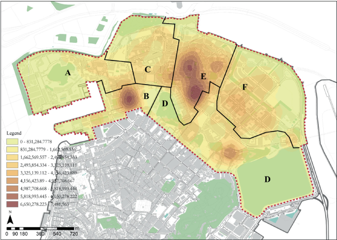
Government agencies POI nuclear density. (Image Source: Drawn by the Author)
Fig. 13. 
Attractions POI nuclear density. (Image Source: Drawn by the Author)
Fig. 14. 
Public facilities POI nuclear density. (Image Source: Drawn by the Author)


4.3 Correlation Analysis of Road Network and Function Aggregation
Various types of functional businesses in the Northern District of Macau present the different forces of urban space and road networks in different forms of agglomeration. The analysis of the three-parameter variables and eight types of functional POI core density of the road network shows:
-
①
Commercial POI is mainly concentrated in the Zone E with strong local integration and selectivity. Degree of influence.
-
②
The concentration of various POIs in Zone A, Zone D and Zone F with high global depth is low, indicating that the convenience of roads has a positive correlation with the distribution of business types. In addition, the concentration of POI in residential areas are less affected by the global depth, and residential areas and commercial areas are highly integrated.
-
③
There are six types of business, transportation, residential quarters, government agencies, scenic spots and public facilities that are positively correlated with road integration. The agglomeration of these six types of business is subject to a high degree of global and local integration, indicating that it has good accessibility can create convenient residents’ services. The weaker correlations with road integration are education and corporate businesses. Educational institutions are mostly located in living quarters, while corporate businesses have a clear location division and are less affected by traffic arterial hubs.
-
④
Zone A and Zone F have a high degree of integration and selectivity. For example, the Ilha Verde in Zone A and Avenida Doutor MA Man Kei in Zone F have high development potential, but the concentration of commercial POI in this area is relatively low. The commercial vitality is insufficient and needs to be continuously developed.
-
⑤
In general, the degree of integration, choice, and depth of roads in the North District, that is, the accessibility, passability, and convenience of the roads will affect commerce, transportation, residential communities, government agencies, scenic spots, and public The agglomeration of 6 types of functional business formats such as facilities, among which the degree of local integration and choice has an obvious effect on commercial agglomeration, while the distribution of education and companies is less affected by roads. The agglomeration of residential quarters and commerce is highly integrated. The permeability of the district is high, and the residential district has no clear directionality.
5 Conclusion
The distribution characteristics of urban POI data reflect the level of vitality of different regions. Scientific analysis tools can be used to objectively and quantitatively analyze the characteristics of urban spatial structure and function distribution. Taking the northern area of Macau as an example, combining the research methods of space syntax and POI nuclear density, it is found that: ① The northern area of Macau has a significant double-centre structure, namely the Iao Hon and Areia Preta Area (Zone E) and Fai Chi Kei District (Zone B), and is positively correlated with road integration and selectivity, and global depth is negatively correlated with commercial distribution. ② Ilha Verde District (Zone A) on the west side of the North District and the new reclamation area of Novos Aterros da Areia Preta Area (Zone F) on the east side are unevenly distributed, but the local roads have certain traffic advantages in terms of integration and choice. Targeted development will activate the commercial vitality of the area. ③ In the road structure indicators, it is shown that the degree of local integration and the degree of local selection has a great impact on commercial agglomeration, reflecting the close relationship between the accessibility and passability of pedestrian traffic and the commercial distribution of the North District, and sustainable optimization of the pedestrian traffic network The structure and road environment promotes a more balanced type and distribution of block functions.
This study shows that different types of data and their analysis results have certain differences. The comparative study of multi-source data can be used to make the analysis results more accurate. Combining space syntax and POI data to study urban spatial structure is feasible, providing a theoretical and technical basis in functional layout, shop location, urban design, etc., and improving the scientificity and objectivity of research in related fields.
References
Dong, C.: High-density architecture. Beijing: China Building Industry Press (2012)
Huang, J., Rong, X.: Macau takes land from the sea.Macau: Overseas Chinese News (1998) (013)
Statistics and Survey Bureau of the Macau Special Administrative Region Government. Demographic Information Database Homepage. https://www.dsec.gov.mo/CensosWebDB/#!/main?lang=moAccessed 21 Sept 2021
Municipal Administration of the Government of Macao Special Administrative Region. Project Information Homepage. https://www.iam.gov.mo/project/c/info/Projectquote.aspx?quotetype=1. Accessed 21 Sep 2021
Yanqun, Y., Kun, C., Yingzi, W.: Research on the vitality of historical districts based on the comprehensive measurement of space syntax and Baidu heat map. Chin. Foreign Arch. 08, 101–106 (2021)
Yao, S., Zhuo Jian, W., Zhiqiang,: Precise urban design: a city morphology oriented to the precise promotion of social effects. Times Arch. 01, 26–33 (2021)
Hengyu, G., Duo, H., Tiyan, S., Xiaoling, Q.: Research on spatial syntax model verification and application in urban design driven by multi-source urban data. Planner 35(05), 67–73 (2019)
Chang, L.: Optimization strategy for walkability of public service facilities under the background of aging. Shanxi Arch. 44(21), 10–12 (2018)
Luo, Q., Wen, Z., Yu, L.: Research on the strategy of improving the street space vitality of small towns under the guidance of environmental behavior: taking zihu town as an example. Urban Dev. Res. 26(02), 20–24 (2019)
Qiang, S., Haishan, X., Xing, L.: An empirical study on the cross-section passenger flow between subway stations by space syntax——taking Beijing, Tianjin and Chongqing as examples. Urban Plan. 42(06), 57–67 (2018)
Sheng, Q., Zhou, C., Kaiwan, K., Lu, A., Shao, M.: Data-based urban design based on spatial syntax model: taking the design of Chaoyang plaza in Jilin City as an example. Landscape Arch. 6(02), 103–113 (2018)
Qiang, S., Yang Zhensheng, L., Le Anhua, C.: Application of network open data in syntactic analysis of urban commercial vitality space. New Arch. 03, 9–14 (2018)
Zhou, Y., Zhang, C., Cui, M., Li, N., Chen, P.: Research on the layout of urban commercial outlets based on spatial syntax and POI information: taking longquanyi district of Chengdu as an example. Sichuan Arch. 34(06), 15–18 (2014)
Xinhua, H., Ying, L., Miao, S., Peng, W.: Beijing street vitality: measurement, influencing factors and planning and design enlightenment. Shanghai Urban Plan. 03, 37–45 (2016)
Huang Mengzhen, G., Hengyu, C.Z.: The influence of road network shape on the spatial distribution of urban internal park system: taking Nansha district of Guangzhou as an example. J. South Chin. Normal Univ. (Nat. Sci. Ed.) 50(03), 78–84 (2018)
Qian, L., Xingzhao, L., Xinxin, L., Sainan, L., Jiaxin, L.: Research on the accessibility of park green space in Nantai Island, Fuzhou based on space syntax. J. Guangxi Normal Univ. (Nat. Sci. Ed.) 39(04), 181–195 (2021)
Heping, L., Zhi, L.: Analysis of the temporal and spatial evolution of urban density and high-density development in China-from 1981 to 2014. Urban Dev. Res. 26(04), 46–54 (2019)
Asami, Y., Kubat, A., Kitagawa, K.: Introducing Third Dimension On Space Syntax: Application On The Historical Istanbul1 (2003)
Acknowledgement
This paper is supported by Macao Special Administrative Region Government Higher Education Fund Special Funding Program for Research on Humanities and Social Fields in Macao Higher Education Institutions (No. HSS-MUST-2020–9).
Author information
Authors and Affiliations
Editor information
Editors and Affiliations
Rights and permissions
Copyright information
© 2022 The Author(s), under exclusive license to Springer Nature Switzerland AG
About this paper

Cite this paper
Zheng, L., Chen, Y. (2022). Research on the Spatial Characteristics of High-Density Urban Road Network and Functional Agglomeration Taking the Northern Part of Macau as an Example. In: Wu, H., et al. Spatial Data and Intelligence. SpatialDI 2022. Lecture Notes in Computer Science, vol 13614. Springer, Cham. https://doi.org/10.1007/978-3-031-24521-3_14
Download citation
DOI: https://doi.org/10.1007/978-3-031-24521-3_14
Published:
Publisher Name: Springer, Cham
Print ISBN: 978-3-031-24520-6
Online ISBN: 978-3-031-24521-3
eBook Packages: Computer ScienceComputer Science (R0)