
Abstract
In the Anthropocene, humans exert a geomorphic force that now rivals that of the natural Earth. Human disturbance of different types at different scales in river systems is a consequence of the perceived needs of human populations; however, these needs have to be in consonance with the needs of the river itself. For instance, the river requires its own space to perform such functions as flooding and floodplain development. Channel flow and forms are deliberately modified with the effect of increasing or decreasing stream power by dam building, embankment, in-channel agriculture, urbanization, gravel mining and dredging, roads, trails, ditches, channelization, and constriction by dikes. All rivers of the world respond to altered conditions of Anthropocene (as well as climate change), and the observed variability through time is important to know the adjustment, complexity and sensitivity against the threshold condition to save water resources. The key research questions are concentrated on the natural and anthropogenic factors and processes related to human modification of the rivers, and the future modelling of human-induced geomorphic changes. It is obvious that these research questions would require a multi-disciplinary approach involving geomorphologists, engineers, ecologists and social scientists. River science and fluvial geomorphology provide an ideal platform to tackle such issues and it is time now to promote this science in India in a major way. This work, thus, intends to review the many facets of the fluvial response to the various stimuli in the Anthropocene. Finally, a summary of the different chapters of this multi-contributed volume has been presented to reveal the recent progress in the field of river science and water resources in the Anthropocene.
Access provided by Autonomous University of Puebla. Download chapter PDF
Keywords
1 Introduction
The Anthropocene epitomizes the time period of intensified human action since human impacts become one of the key external forcings on the natural processes, and the term, introduced by Crutzen (2002), reflects an epoch when human activities have become so profound and pervasive that they rival or exceed the great forces of nature in influencing the various functions of Earth system (Das et al., 2021; Gibling, 2018; Goudie & Viles, 2016). The main point of interest is that human civilisations have been reshaping the landforms and landscapes for thousands of years, developing anthropogenic geomorphic features ranging the earthworks and reservoirs to settlements, mining, roads, canals, ditches and plough furrows that have discrete appearances (degradation of floodplain environment and river modification) compared with landforms produced by the natural processes (Das et al., 2021; Tarolli et al., 2019). In the epoch of Anthropocene, the components of fluvial systems are largely altered by human interventions in the form of large-scale dams and barrages, changes in the land use and land cover, road-stream crossing, mining of sand and gravel, mushrooming of brickfield and expansion of modern agriculture, industrial growth and urbanization (Graf, 2006; Jain et al., 2016; James, 2013; Tarolli et al., 2019). Thus, the present-day development pattern poses a threat to the fluvial system, especially the riverine ecosystem. In brief, water pollution, eutrophication and related damages to aquatic organisms are the major concerns of the fluvial system which consists of a network of channels and associated environments that transport sediment from a drainage basin to a depositional basin. Therefore, rivers are central to the debate about the Anthropocene because many human activities from antiquity focused on channels and floodplains (Gibling, 2018).
The ancient Greek philosopher Heraclitus famously asserted that one can never step into the same river twice, thus providing a physical metaphor for life’s constant change (Poff, 2014). The riverine environment and floodplains are constantly changed due to the unaccountable growth of the human population and technological advances in the Anthropocene. Ecological complexity in river basins has been conceptualized scientifically by viewing these systems as existing in a kind of dynamic equilibrium, or balance, defined by prevailing hydro-climatic and watershed controls and by evolutionary species pools (Poff, 2014). Humans act to disrupt components of this equilibrium, causing “impacts” in the system (Poff, 2014). The human role as a transforming agent in rivers is also rich (Gregory, 2006), and today there is a general recognition of the environmental damage derived from the use and control of rivers for navigation, water consumption and power generation (García et al., 2021). A large geomorphological tradition has studied human effects on river systems (e.g., Belletti et al., 2020; García et al., 2021; Piégay et al., 2020; Scorpio & Rosskopf, 2016; Stecca et al., 2019) and opened new horizons for their conservation, restoration and coexistence (Table 1). In the last twenty years, river concerns are highly focused on by many researchers and planners, and river restoration has emphasized rehabilitating water (first) and sediment (later) fluxes (Ibisate et al., 2016; Tena et al., 2020), longitudinal connectivity, ecological integrity (Downs et al., 2011; Vugteveen et al., 2014), ecosystem services (Palmer et al., 2014; Thorp et al., 2006) or ecological justice (participation and equity).
Geomorphologists began to make their way slowly in river management, and although there is a long way for geomorphology to fully participate in the understanding of river ecology, proposals such as ‘Fluvial Hydrosystems’ (García et al., 2021). The evolution of environmental concerns and integrated approaches have converged in river sciences, within which geomorphology (and hydrology) has a critical place because it provides a holistic perspective and is key to improving river status (García et al., 2021). In Anthropocene a big question therefore is: can we continue to create ‘disturbances’ at different scales in the large river systems without obtaining a detailed multi-disciplinary knowledge base of these systems? (Sinha et al., 2013). Human disturbance of different types at different scales in river systems is a consequence of the perceived needs of human populations; however, these needs have to be in consonance with the needs of the river itself. For instance, the river requires its ‘own space’ to perform such functions as flooding and floodplain development (Sinha et al., 2013). Now, we must learn and effect change at a rate that is faster than the rate at which humans are currently using and degrading earth’s limited resources. One premise of the Rivers of the Anthropocene study is that a transdisciplinary approach by the scholars of earth sciences will be more effective than single-, multi-, or interdisciplinary approaches to helping societies manage rivers. In the following sections the main focus and explanation are primarily concentrated on the stages of anthropogenic interventions in rivers, the human role as a geologic and geomorphic agent, changing perspectives of anthropogenic fluvial system, key concepts, principles and approaches of fluvial geomorphology applied in Anthropocene, the role of scholar and society on the sustainability of rivers, and research needs in India.
2 Stages of Anthropogenic Modifications in Fluvial System
A detectable human imprint on the environment extends back for thousands of years (Gibling, 2018). The human river footprint has expanded with great rapidity: such a duration is commonly represented in the geological record by a few metres of sediment on an alluvial plain, a few avulsions of a trunk channel, or part of a rhythm of sea-level rise (Gibling, 2018). Important earlier human effects with significant environmental consequences include megafaunal extinctions between 14,000 and 10,500 cal yr BP (Braje & Erlandson, 2013); domestication of plants and animals close to the start of the Holocene at 11,700 cal yr BP; agricultural practices and deforestation at 10,000 to 5000 cal yr BP (Braje & Erlandson, 2013); and widespread generation of anthropogenic soils at about 2000 cal yr BP (Ruddiman, 2003). The following chronological stages (Stages 2–6 encompassed less than 10,000 years of river history) of human footprints were detected in the river basins of the world (Brown et al., 2013, 2017; Edgeworth et al., 2015; Gibling, 2018; Klein Goldewijk et al., 2017):
-
Minimal river effects before about 15,000 cal yr BP (Late Pleistocene), with the use of fire and gathering of plants and aquatic resources;
-
Minor river effects from increased cultivation after about 15,000 cal yr BP, with plant and animal domestication after about 10,700 cal yr BP (activity included fisheries, ochre mining, and construction of early settlements);
-
Agricultural era after about 9800 cal yr BP, with legacy sediments, widespread fire use, the first dams and irrigation, and mud-brick manufacture;
-
Irrigation era from about 6500 cal yr BP, with large-scale irrigation, major cities, the first large dam, urban water supplies, expanded groundwater use, river fleets, and alluvial mining;
-
Engineering era with embankments, dams, and watermills after about 3000 cal yr BP to about 1750 CE, especially in the Chinese and Roman empires, and the stage marks the onset of large-scale river engineering with the management of extensive embankments, canals, dams, and urban water supplies.; and
-
Technological era after about 1800 CE showed the modern Big Dam Era from 1882 onwards ushered in technological river modification and regulation such that most rivers on Earth now experience major anthropogenic influence (Fig. 1).
Fig. 1 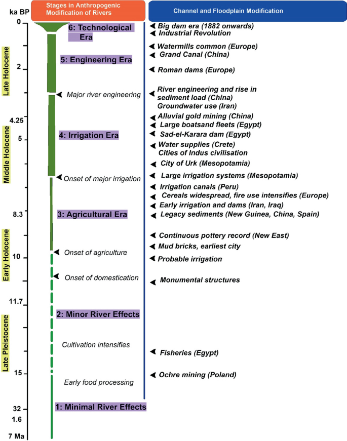
A summary on timelines and stages of human modification of rivers during Anthropocene, reflecting six stages of anthropogenic modification (modified from Gibling, 2018)

3 Modern River Systems and Human Activity
From Late Pleistocene and Holocene epoch, the key anthropogenic influences on modern river landscapes (Table 2) are recognised fire use, agriculture and deforestation, animals used for food, ploughing, and transport, an embankment along channels, dams and irrigation systems, navigation and bank structures, city water supplies, warfare, extraction of channel and floodplain materials, extraction of aquatic materials and cultural events (Gibling, 2018). The influences may have direct or indirect effects on rivers, commonly altering the boundary conditions of processes such as sediment erosion and transport. They are substantiated in the table with references that demonstrate their impact in modern and sub modern settings. Fire is used for hunting and deforestation and, along with other anthropogenic vegetation changes, converts forests and other undisturbed ecosystems to cropland and grazing land, commonly with terrace construction. Cropland, grazing land and animal collectively influence the reduction of regolith strength and enhance erosion, increasing sediment supply to rivers (Islam et al., 2021a, b). More direct effects on rivers involve the modification of channels and changes to the connectivity of channels and floodplains, including the transfer of large volumes of water to floodplains for irrigation and other human uses (Sarkar & Islam, 2019; Islam et al., 2021b). Irrigation systems are commonly linked to dams and barrages, with the use of specialised irrigation technology (Islam et al., 2020). Bridges and river crossings are a common focus for human activity. The deliberate breaching of embankments during warfare has been responsible for catastrophic avulsions and widespread floodplain aggradation. The third set of influences involves resource extraction from floodplains and channels, commonly yielding technofossils. Major cultural events take place at rivers around the world. For example, tens of millions of people attend the festival of Khumba Mela, held every twelve years at the confluence of the Ganges and Yamuna rivers in India.
4 Human Activity and River Metamorphosis
River metamorphosis, introduced by Schumm (1969), reflects that natural and anthropogenic disturbances can lead to a wide range of responses in the fluvial system. It follows then that readjustments to a new set of environmental conditions (threshold and complex response) can affect the physical dispersal of sediment-borne trace metals in a variety of ways, each of which may vary in time and position along the valley floor (Miller & Miller, 2007). Rivers respond to altered conditions (e.g., intrinsic and extrinsic factors), therefore variability through time is important because a river or a reach may be out of character for a period as it adjusts. For example, Figs. 2 and 3 suggest how different types of channels respond to change (i.e., dam closure or river impoundment). A list of sixteen responses of channels to change, and the four major variables that influence them are summarized in Table 3. Time (history) is included with discharge (increase or decrease), sediment load (increase or decrease), and base level change (up or down), because channels change naturally through time, and time is an index of energy expended or work done. The changes are grouped according to the results of the change (erosion, deposition, pattern change, and metamorphosis). In Table 3, the changes that will be affected by the passage of time or by a change of discharge, sediment load or base level are indicated by an X.

Identified orders of changes in an impounded river system (dam purpose and reservoir size), affecting flow regime, water quality and sediment load (modified from Casado, 2013)

A conceptual scheme to understand the fluvial response to dam closure and river metamorphosis (modified from Casado, 2013)
Different types of human activity are known to cause channel erosion. These factors can be divided into four effects: reduction of sediment weight, increase in annual discharge and maximum discharge, increase in flow density and channel gradient. It was recognized that sixteen types of human activity can cause channel incision (Casado, 2013; Schumm, 1999, 2005): (1) dam construction; (2) sediment diversion, (3) flow diversion, (4) urbanization, (5) dam removal or failure, (6) lowering lake and reservoir levels, (7) meander cutoff, (8) underground mining, (9) groundwater withdrawal and hydrocompaction, (10) gravel and sand mining, (11) dredging, (12) roads, trails and ditches, (13) channelization, (14) construction of flow, (15) deforestation and (16) fire. Low sediment load may be due to the construction of dams, urbanization, expansion of silt in other channels like canals and gravel mining and dredging (Schumm, 2005). Average discharge and maximum discharge can be increased by flow diversion, urbanization, removal of dams and deforestation. The flow can be centralized by increasing the strength of the flow through gravel excavation and dredging, road, trail, shaft, channelization and compression by dyke. The gradient can be increased by removing dams, lowering water levels in lakes and reservoirs, mandar cutoff, mining, drainage and hydro-condensation, gravel mining, dredging and channelization (Schumm, 2005).
In the context of the Ganga-Brahmoutra-Meghna Delta, channel metamorphosis is a significant facet of the evolution of river courses in the Anthropocene due to different anthropogenic interventions. Of them, the construction of dams and barrages over the rivers plays a pivotal role in channel modifications. For example, the construction Farakka Barrage Project (FBP over the Ganga river created the problem of in-channel sedimentation above the FBP and riverbank erosion below the barrage along the River Bhagirathi and the Padma (Islam & Guchhait, 2017). The problem of bank erosion, meandering and braiding are the major responses due to the variable river regime in the lean months induced by the Indo-Bangladesh water-sharing treaty (Guchhait et al., 2016; Islam & Guchhait, 2020). The disconnection of the Jalangi River, Ichhamati and Mathabhanga-Churni are also to some extent triggered by the reduced flow through the Padma from the FBP in the lean months (Sarkar et al., 2020). Similarly, the hydro-geomorphological evolution of the other rivers of the Bengal Basin like the Damodar river (Bhattacharyya, 2011; Ghosh & Guchhait, 2014), and the Mayurakshi River (Islam & Ghosh, 2022; Pal & Mandal, 2017) are also well documented in the context of dams and barrages. Besides, channel modifications are revealed through the impact of road-stream crossing (Roy & Sahu, 2018), agricultural expansion (Sarkar et al., 2020), deforestation (Islam et al., 2020), sand and gravel mining (Islam et al., 2021a, b; Pal & Mandal, 2017), development of brick kiln industries (Das & Bhattacharya, 2020), in different rivers basins of the GBM delta.
5 Plastics in Fluvial Deposits
Plastics, a signature of the human footprint, are existing in all ecosystems, and these are found in a variety of environments around the world. The global abundance of plastics, the long-term effects, the apparent temporal depiction of plastics, and the lack of a geological background have also led plastics to be considered a potential indicator of a proposed new post-Holocene Cenozoic era, ‘Anthropocene’ (Weber & Lechthaler, 2021; Zalasiewicz et al., 2011). In principle, the first plastic deposits discovered in the marine environment are understood to be the last point of the plastic transport system that extends from land to oceans via rivers (Weber & Lechthaler, 2021). The importance of Anthropocene rivers is highlighted that since the lion's share of global plastics production is produced and consumed on land, it has been shown that rivers and river systems are the main plastic corridors and transport routes in the environment (Weber & Lechthaler, 2021). Ubiquitous in the environment, plastics have the potential to become a ‘novel’ stratigraphic marker for recent sediments, and especially fluvial sediments. This potential is due to their occurrence in fluvial systems, their properties, and their preservation. The detection of plastic particles is usable in two different ways: (1) as a proxy of environmental contamination, and (2) as marker in a sedimentary context. In the future, it will be possible to record recent sediment dynamics in fluvial systems, to classify them stratigraphically, and monitor them (Weber & Lechthaler, 2021). As a new specific marker, the protective mask has entered the environment during the Covid-19 pandemic situation in the world. It may emerge in the future as a 2020 marker due to its visual properties and species composition. Despite the widespread use of face masks in certain regions or during previous virus outbreaks, the explosive global increase in mask production in 2020 is accompanied by a worldwide spread and high potential for littering of used masks (Weber & Lechthaler, 2021).
6 Application of Geomorphic Concepts in Anthropocene Rivers
In the future, a growing population and resource exploitation will cause the dependence of a greater number of human beings on our river systems. According to Sinha et al. (2013) a big question therefore is: can we continue to create ‘disturbances’ at different scales in the large river systems without obtaining a detailed multi-disciplinary knowledge base of these systems? Technological interventions should therefore be practised on the basis of a holistic approach encompassing all aspects of river systems and ‘River Science’ offers such an opportunity (Sinha et al., 2013). River science refers to the study of a variety of processes affecting river systems. This is a truly interdisciplinary science and requires the explicit joining of two or more areas of understanding into a single conceptual-empirical structure. To study the anthropogenic influence on river dynamics Jain et al. (2012) prescribed the following geomorphic concepts and principles of river science which can be applied in Indian rivers to know the effects of Anthropocene:
-
Equilibrium Process and State—The fluvial system tries to maintain a constant linear relationship between input (cause) and output (effect) and the system oscillates around that linear relationship to achieve an equilibrium state or form. An equilibrium landform tends to maintain relatively stable characteristics even after minor perturbations, but human disturbance can create an imbalance in the system.
-
Magnitude and Frequency—The magnitude of an event (e.g., dam) generally refers to the amount of work carried out or the degree of landform change experienced due to river modification. The frequency of an event of a specific magnitude is expressed as the average length of time between events of that magnitude.
-
Threshold—Threshold steps are responsible for achieving a new equilibrium stage after any major or prolonged human perturbation, that results in a nonlinear relationship between forcing mechanism and landform change. River planform changes may occur through the crossing of internal or external thresholds.
-
Sensitivity—The sensitivity of the fluvial system describes its propensity for change and its ability to absorb any disturbing forces. If a geomorphic system is close to the threshold value, it will be highly sensitive to change.
-
Connectivity—The way in which different landscape compartments (i.e., a landscape may be divided into different compartments which may be a large landform or a summation of smaller landforms) fit together in the catchment in a given time-frame.
-
Complexity—Nonlinear relationship between the driving and geomorphic response at different space and time reflects the complexity in the fluvial system. In a complex system, the outputs will be inconsistent with inputs.
7 Living with Rivers
The human role as a transforming agent in rivers is also rich, and nowadays there is a general recognition of the environmental damage derived from the use and control of rivers for navigation, water consumption and power generation. A large geomorphological tradition has studied human effects on river systems and opened new horizons for their conservation, restoration and coexistence (García et al., 2021). From a particular perspective, geomorphology spans greater openness and the search for a niche from which it can develop more influence in river management. Geomorphologists began to make their way slowly in river management, and although there is a long way for geomorphology to fully participate in the understanding of river ecology, proposals such as ‘Fluvial Hydrosystems’ (García et al., 2021). Under the paradigm ‘Living with rivers’, Raven et al. (2002) and Garcia et al. (2021) proposed to manage and restore rivers as a hybrid plan of biophysical and socio-political processes moving around the concepts of “work with nature, not against it” or “working with natural processes”. Three principles are acknowledged to achieve the goal (García et al., 2021):
-
Work Across Disciplinary Frontiers—The multiple approaches from which a river can be studied imply cross-disciplinary interaction between sciences, mutual respect, and learning about the different visions of the river and the diversity of spatial and temporal scale analysis.
-
Integrated Plans—This principle advocates for the unification of single management or work plan of the projects for river restoration, flood-risk management, and land planning; it considers the three sub-lines inseparable and in permanent feedback. An integrated plan (inclusion of river restoration, flood-risk management and land planning) is, in addition to being a technical process, a socio-political and cultural process to change the relationship between rivers and society.
-
Fluvial Education—The goal of informing people is to correct them is understandings of river behaviour perceived by society, extending these to the forces that control what a river is, what restoration/management is and how it should be applied. This process involves moving from a vision of the river as a resource to a fluvial framework in which societies adapt to the times, forms and processes of rivers.
8 Research Needs
Rivers, because of the services they provide to humans and other forms of life, are effective ecosystems for demonstrating the conflicts that arise when humans do not learn how to curb their desires or share the benefits of nature (Lubinski & Thoms, 2017). Scholars, people with advanced knowledge of a subject, play an important role in showing society the consequences of its decisions and actions (Lubinski & Thoms, 2017). River management strategies all around the world have moved from the engineering dominated command and control approach to an integrated ecosystem-based approach that relies on the synthesis of hydrological, geomorphological and ecological data (Sinha et al., 2013). Attempts are now on to design engineering solutions using the scientific framework of the river system as the basic template for human intervention. Some of the specific research needs and questions in river science of Anthropocene in the Indian context may be framed as follows (Jain et al., 2012; Sinha et al., 2013):
-
1.
How will climate change and anthropogenic intervention affect the hydrological budget of the river system, their geomorphology, sediment transport characteristics and connectivity?
-
2.
How dams and other river engineering structures can modify the stream hydrology, fluvial processes and water resources?
-
3.
How is the river morphology related to current discharge and sediment load and how it is responding to changes in hydrologic regime due to natural and anthropogenic processes? How to differentiate the impacts of natural and anthropogenic impacts on river systems?
-
4.
What is the sensitivity of the different reaches to known external forcings and how can such differential sensitivity help to prioritize management planning in a large river?
-
5.
How can we model the future geomorphological (physical) changes on the basis of modelled future changes in flux and energy, i.e., prediction of geomorphic change on the basis of the anthropogenic change prediction model?
-
6.
How have urbanized centres (megacities) affected the physical–chemical characteristics of the reaches of a large river and the river as a whole?
-
7.
What is the nature of river–groundwater connectivity and what are its implications on water resources management and riverine ecosystem management?
-
8.
What are the limits to the human disturbance of a large river system? How do we define and estimate the values of environmental flow at different reaches?
9 Summary of the Chapters
The chapters of the present volume will focus on the research needs mentioned above. The present volume contains 25 chapters including introductory chapter which has reviewed the various concepts and issues of the fluvial systems in the Anthropocene. Moreover, this chapter has set the tune of the volume by introducing the major areas of research that need attention from the different disciplines concerned with the river. Chapter 2 is concerned with the holistic view of the river and aquatic system revealing the interconnected nature of the river as a physical entity and social entity. Chapter 3 deals with the distressed conditions of the river from an evolutionary perspective. Chapter 4 presents conceptual and theoretical developments in the ecogeomorphological behaviours of the river and their application to river restoration. Rivers are probably lying in every pore of the society which is reflected in the literature. Thus, Chapter 5 very pertinently portrays the impact of the river on man and society in the light of some Bengali novels. Chapter 6 deals with the poor water quality due to unscrupulous human intervention in the Bhagirathi River in West Bengal, India. Similarly, Chapter 7 shows the pity condition of the Mithi River in Maharashtra, India. River water quality is below the standard for potable use even during the COVID 19 pandemic situation that calls for intervention from various stakeholders to restore this fluvial system. Chapter 8 reveals the flood susceptibility of the Mayurakshi river basin using Geospatial techniques and multi-criteria analysis. Chapter 9 critically examines the geometric irony of the Ajay river where narrowing of channel width downstream has been clearly observed. The natural forcing and role of human intervention are pivotal to such river morphology. Chapter 10 addresses the prioritization of the Pagla Jhora micro basin in the Darjeeling hilly area based on the fluvial morphometry parameters of a basin. The next chapter (11) similarly shows the sub-watershed prioritization using basin morphometry in the semiarid area like the Puruliya upland. Chapter 12 is an attempt to portray the integrated watershed development using correlation and association analysis between drainage basin morphometry and LULC characteristics. Chapter 13 also attempts to assess the nature of flood risk of sub-watersheds of Teesta River Basin using morphometric parameters through the application of Hazard Degree (HD) and Principal Component Analysis with Weighted Sum Approach (PCAWSA). Chapter 14 is concerned with the flood hazard in the North Bengal region and it portrays that flood-affected area has diminished in the recent decade, however, it is still occurring on a regular basis even after the structural interventions in the river basin. Chapter 15 intends to show the channel dynamics of the Hari River and its tributaries in the polder area of Bangladesh. The study indicates that the shifting of the channel is slow, however, the narrowing of the channel due to different natural and anthropogenic drivers poses a threat to its existence in future. Chapter 16 has succinctly portrayed the intense human interventions in the form of agricultural development and urbanization on the decay and fragmentation of the palaeochannels of the Damodar Fan Delta, India using a widely accepted approach in the Anthroplogeomorphology i.e. EPA (excavation, planation and accumulation). Similarly, Chapter 17 applying the Multi-temporal Satellite Images and GIS has focused on the historical evolution and decay of the Jamuna River in West Bengal, India in recent times due to escalating human interventions. However, the outbreak of COVID 19 pandemaic has restricted human movement and curtailed the level of pollution of the river. Certainly, Chapter 18 is vital in the context of the critical assessment of river health in the wake of COVID 19 in India. Chapter 19 is concerned with the poor water quality and decay of the ox-box lakes of the Bhagirathi and Jalangi rivers due to accelerated human intervention. In the context of the Anthropocene, the growth of aquaculture ponds and methane emission is very crucial. Chapter 20 demonstrates the contrasting diffusive methane emission from two closely situated aquaculture ponds of varying salinity located in a wetland in eastern India. The sewage–fed freshwater and oligohaline aquaculture ponds show a marked difference in the methane emission. Besides the problems of the river and wetlands, the issues of the soil, and groundwater of the river basi are also important in the recent age (Human age). Thus, Chapter 21 portrays the accelerated soil loss from a tropical river basin (Jayanti River Basin, India) using the RUSLE model. Chapter 22 attempts to assess irrigation-induced groundwater depletion and groundwater prospects in an alluvial river basin of West Bengal, India. This chapter has examined how the groundwater exploitation for irrigation in Boro (summer rice) cultivation has led to the fall in groundwater levels. Similarly, Chapter 23 depicts the groundwater availability zone in Bangladesh using geo-spatial techniques. Finally, this volume also takes the consideration the role of the river in the social and cultural perspectives. Therefore, Chapter 24 examines the Mayo Tsanaga, Kaliao and Mizao (Maroua, Far North Cameroon) as a heritage for socio-economic activities. Chapter 25 similarly uphold the role of the river in Indian tourism and also the significance of river-based tourism towards the achievement of sustainable development goals.
10 Conclusions
The fluvial systems, wetlands, and water resources are threatened in the Anthropocene due to the accelerated human interventions in different forms ranging from large-scale dams and barrage to the practices like agricultural expansion, groundwater exploitation and irrigation, and urbanization. This chapter has critically examined the basic principles, and concepts of the river metamorphosis in the context of anthropogenic activities, especially construction dams. Moreover, pollution of the river and water bodies is also sketched out briefly. Finally, this chapter has clearly identified the major research areas where the prime focus is needed to restore the fluvial system area indicated and the chapter briefs are also included to cover those research areas. This work will certainly aware the scientific community sparks their cognition about the current health of the fluvial systems and river basins so that the future restoration of the river basin may be one of the prime goals of the various stakeholders across the world.
References
Belletti, B., Leaniz, C. D., Jones, J., & Bizzi, S. et al. (2020). More than one million barriers fragment Europe’s rivers. Nature, 588, 436–441. https://doi.org/10.1038/s41586-020-3005-2.
Bhattacharyya, K. (2011). The lower Damodar River, India: Understanding the human role in changing fluvial environment. Springer.
Bhunia, G. S., Chatterjee, U., Lalmalsawmzauva, K. C., & Shit, P. K. (2022). Anthropogeomorphology: A geospatial technology based approach. Springer. https://doi.org/10.1007/978-3-030-77572-8
Braje, T. J., & Erlandson, J. M. (2013). Human acceleration of animal and plant extinctions: A Late Pleistocene, Holocene, and Anthropocene continuum. Anthropocene, 4, 14–23.
Brown, A., Toms, P., Carey, C., & Rhodes, E. (2013). Geomorphology of the Anthropocene: Time-transgressive discontinuities of human-induced alluviation. Anthropocene, 1, 3–13.
Brown, A. G., Tooth, S., Bullard, J. E., Thomas, D. S. G., Chiverrell, R. C., Plater, A. J., Murton, J., Thorndycraft, V. R., Tarolli, P., & Rose, J. (2017). The geomorphology of the Anthropocene: Emergence, status and implications. Earth Surface Processes and Landforms, 42, 71–90.
Brown, E. C. (1970). Man shapes the earth. The Geographical Journal, 136(1), 74–85.
Brown, T. A., Jones, M. K., Powell, W., & Allaby, R. G. (2009). The complex origins of domesticated crops in the Fertile Crescent. Trends in Ecology & Evolution, 24, 103–109.
Casado, A. (2013). Human impacts and fluvial metamorphosis: The effects of flow regulation on the hydrology, morphology and water temperature of the Sauce Grande River, Argentina. Geography. Université Blaise Pascal—Clermont-Ferrand II. https://tel.archives-ouvertes.fr/tel-01077867
Crutzen, P. J. (2002). Geology of mankind. Nature, 415(23). https://doi.org/10.1038/415023a.
Das, B. C., & Bhattacharya, S. (2020). The Jalangi. In Anthropogeomorphology of Bhagirathi-Hooghly river system in India (p. 381). CRC Press.
Das, B. C., Ghosh, S., Islam, A., & Roy, S. (2021). Anthropogeomorphology of Bhagirathi-Hooghly river system in India (edited volume). CRC Press. https://doi.org/10.1201/9781003032373
Downs, P. W., Singer, M. S., Orr, B. K., Diggory, Z. E., Church, T. C., & Stella, J. C., (2011). Restoring ecological integrity in highly regulated rivers: the role of baseline data and analytical references. Environmental Management, 48, 847–864.
Dunne, T., Western, D., & Dietrich, W. E. (2011). Effects of cattle trampling on vegetation, infiltration, and erosion in a tropical rangeland. Journal of Arid Environments, 75, 58–69.
Edgeworth, M., Richter, D. D., Waters, C. N., Haff, P., Neal, C., & Price, S. J. (2015). Diachronous beginnings of the Anthropocene: The lower bounding surface of anthropogenic deposits. The Anthropocene Review, 2, 33–58.
García, J. H., Ollero, A., Ibisate, A., Fuller, I. C., Death, R. G., & Piegay, H. (2021). Promoting fluvial geomorphology to “live with rivers” in the Anthropocene Era. Geomorphology, 380, 1. https://doi.org/10.1016/j.geomorph.2021.107649
Gregory, K. J. (2006).The human role in changing river channels. Geomorphology, 79(3–4), 172–191.
Ghosh, P. K., Bandhyopadhyay, S., Jana, N. C., & Mukhopadhayay, R. (2016). Sand quarrying activities in an alluvial reach of Damodar River, Eastern India: Towards a geomorphic assessment. International Journal of River Basin Management, 14(4), 477–489.
Ghosh, S., & Guchhait, S. K. (2014). Hydrogeomorphic variability due to dam constructions and emerging problems: A case study of Damodar River, West Bengal, India. Environment, Development and Sustainability, 16(3), 769–796.
Ghosh, S., & Guchhait, S. K. (2016). Dam-induced changes in flood hydrology and flood frequency of tropical river: A study in Damodar River of West Bengal, India. Arabian Journal of Geosciences, 9, 90. https://doi.org/10.1007/s12517-015-2046-6
Ghosh, S., & Illahi, R. A. (2020). Responses of fluvial forms and processes to human actions in the Damodar River Basin. In B. C. Das, S. Ghosh, A. Islam, & S. Roy (Eds.), Anthropogeomorphology of Bhagirathi-Hooghly river system in India. CRC Press, Taylor and Francis Group, https://doi.org/10.1201/9781003032373-7
Gibling, M. R. (2018). River systems and the anthropocene: A late pleistocene and holocene timeline for human influence. Quaternary, 1(3), 21. https://doi.org/10.3390/quat1030021.
Goudie, A. S., & Viles, H. A. (2016). Geomorphology in the Anthropocene. Cambridge University Press.
Guchhait, S. K., Islam, A., Ghosh, S., Das, B. C., & Maji, N. K. (2016). Role of hydrological regime and floodplain sediments in channel instability of the Bhagirathi River, Ganga-Brahmaputra Delta, India. Physical Geography, 37(6), 476–510.
Hudson, P. F., Middelkoop, H., & Stouthamer, E. (2008). Flood management along the Lower Mississippi and Rhine Rivers (The Netherlands) and the continuum of geomorphic adjustment. Geomorphology, 101, 209–236.
Ibisate, A., Ollero, A., Ballarín, D., Horacio, J., Mora, D., Mesanza, A., Ferrer-Boix, C., Acín, V., Granado, D., & Martín-Vide, J.P. (2016). Geomorphic monitoring and response to two dam removals: rivers Urumea and Leitzaran (Basque Country, Spain). Earth Surface Processes and Landforms, 41(15), 2239–2255.
Islam, A., Barman, S. D., Islam, M., & Ghosh, S. (2020). Role of human interventions in the evolution of forms and processes in the Mayurakshi River Basin. In Anthropogeomorphology of Bhagirathi-Hooghly river system in India (pp. 135–187). CRC Press.
Islam, A., Das, B. C., Mahammad, S., Ghosh, P., Barman, S. D., & Sarkar, B. (2021a). Deforestation and its impact on sediment flux and channel morphodynamics of the Brahmani River Basin, India. In Forest resources resilience and conflicts (pp. 377–415). Elsevier.
Islam, A., & Ghosh, S. (2022). Community-based riverine flood risk assessment and evaluating its drivers: Evidence from Rarh Plains of India. Applied Spatial Analysis and Policy, 15(1), 1–47.
Islam, A., & Guchhait, S. K. (2017). Analysing the influence of Farakka Barrage Project on channel dynamics and meander geometry of Bhagirathi river of West Bengal, India. Arabian Journal of Geosciences, 10(11), 1–18.
Islam, A., & Guchhait, S. K. (2020). Characterizing cross-sectional morphology and channel inefficiency of lower Bhagirathi River, India, in post-Farakka barrage condition. Natural Hazards, 103(3), 3803–3836.
Islam, A., Sarkar, B., Saha, U. D., Islam, M., & Ghosh, S. (2021b). Can an annual flood induce changes in channel geomorphology? Natural Hazards, 111, 1019–1046.
Jain, V., Sinha, R., Singh, L. P., & Tandon, S. K. (2016). River systems in India: The Anthropocene context. Proceedings of the Indian National Science Academy, 82(3), 747–761.
Jain, V., Tandon, S. K., & Sinha, R. (2012). Application of modern geomorphic concepts for understanding the spatio-temporal complexity of the large Ganga river dispersal system. Current Science, 103(11), 1300–1319.
James, L. A., & Marcus, W. A. (2006). The human role in changing fluvial systems: Retrospect, inventory and prospect. Geomorphology, 79, 152–171.
James, L. A. (2013). Legacy sediment: Definitions and processes of episodically produced anthropogenic sediment. Anthropocene, 2, 16–26.
Kar, S., Ghosh, I., Ghosh, A., Aitch, P., & Bhandari, G. (2017). Determination of Water Quality Index (WQI) during mass bathing in different ghats of River Ganga in Howrah and North 24 Parganas District, West Bengal, India. International Journal for Research in Applied Science & Engineering Technology, 5, 1097–1104.
Klein Goldewijk, K., Dekker, S. C., & van Zanden, J. L. (2017). Per-capita estimations of long-term historical land use and the consequences for global change research. Journal of Land Use Science, 12, 313–337.
Kondolf, G. M. (1997). Hungry water: Effects of dams and gravel mining on river channels. Environmental Management, 21, 533–551.
Lary, D. (2001). Drowned earth: The strategic breaching of the Yellow River Dyke, 1938. War History, 8, 191–207.
Leonard, L. A., Wren, P. A., & Beavers, R. L. (2002). Flow dynamics and sedimentation in Spartina alterniflora and Phragmites australis marshes of the Chesapeake Bay. Wetlands, 22, 415–424.
Lubinski, K., & Thoms, M. (2017). Rivers, scholars, and society: A situation analysis. In J. Kelly et al. (eds.), Rivers of the Anthropocene. University of California Press. https://doi.org/10.1525/luminos.43.e.
Miller, J. R., & Miller, S. M. O. (2007). Contaminated rivers. Springer. https://doi.org/10.1007/1-4020-5602-8
Nir, D. (1983). Man, a geomorphological agent: An introduction to anthropic geomorphology. Springer.
Pal, S., & Mandal, I. (2017). Impacts of stone mining and crushing on stream characters and vegetation health of Dwarka River Basin of Jharkhand and West Bengal, Eastern India. Journal of Environmental Geography, 10(1–2), 11–21.
Palmer, M. A., Hondula K. L., & Koch, B. J. (2014). Ecological restoration of streams and rivers: Shifting strategies and shifting goals. Annual Reviews , 45, 247–269.
Piégay, H., Arnaud, F., Belletti, B., Bertrand, M., Bizzi, S., Carbonneau, P., Dufour, S., Liébault, F., Ruiz-Villanueva, V., & Slater, L. (2020). Remotely sensed rivers in the Anthropocene: state of the art and prospects. Earth Surface Processes and Landforms, 45(1), 157–188. https://doi.org/10.1002/esp.4787
Poff, N. L. R. (2014). Rivers of Anthropocene? Frontiers in Ecology and the Environment, 12(8), 427. https://doi.org/10.1890/1540-9295-12.8.427
Raven, P. J., Holmes, N. T. H., Charrier, P., Dawson, F. H., Naura, M., & Boon, P. J. (2002). Towards a harmonized approach for hydromorphological assessment of rivers in Europe: A qualitative comparison of three survey methods. Aquatic Conservation, 12(4), 405–424.
Roy, S., & Sahu, A. S. (2018). Road-stream crossing an in-stream intervention to alter channel morphology of headwater streams: Case study. International Journal of River Basin Management, 16(1), 1–19.
Ruddiman, W. F. (2003). The anthropogenic greenhouse era began thousands of years ago. Climate Change, 61, 261–293.
Santhosh, V., Padmalal, D., Baijulal, B., & Maya, K. (2013). Brick and tile clay mining from the paddy lands of Central Kerala (southwest coast of India) and emerging environmental issues. Environment and Earth Science, 68, 2111–2121.
Sarkar, B., & Islam, A. (2019). Assessing the suitability of water for irrigation using major physical parameters and ion chemistry: A study of the Churni River, India. Arabian Journal of Geosciences, 12(20), 1–16.
Sarkar, B., Islam, A., & Das, B. C. (2020). Anthropo-footprints on Churni River: A river of stolen water. In Anthropogeomorphology of Bhagirathi-Hooghly river system in India (pp. 433–468). CRC Press.
Schumm, S. A. (1969). River metamorphosis. Journal of the Hydraulics Division, 95(1). https://doi.org/10.1061/JYCEAJ.0001938
Schumm, S. A. (1999). Causes and controls of channel incision. In S. E. Darby & A. Simon (Eds.), Incised river channels: Processes, forms engineering and management (pp. 19–33). New York.
Schumm, S. A. (2005). River variability and complexity. Cambridge University Press. https://doi.org/10.1017/CBO9781139165440
Scorpio, V., & Rosskopf, C. M. (2016). Channel adjustments in a Mediterranean river over the last 150 years in the context of anthropic and natural controls. Geomorphology, 275, 15. https://doi.org/10.1016/j.geomorph.2016.09.017
Sinha, R., Gaurav, K., Chandra, S., & Tandon, S. K. (2013). Exploring the channel connectivity structure of the August 2008 avulsion belt of the Kosi River, India: Application to flood risk assessment. Geology, 41, 1099–1102.
Smith, N. D., Morozova, G. S., Perez-Arlucea, M., & Gibling, M. R. (2016). Dam-induced and natural channel changes in the Saskatchewan River below the E.B. Campbell Dam, Canada. Geomorphology, 269, 186–202.
Stecca, G., Zolezzi, G., Hicks, D. M., & Surian, N. (2019). Reduced braiding of rivers in human-modified landscapes: Converging trajectories and diversity of causes. Earth-Science Reviews, 188, 291–311. https://doi.org/10.1016/j.earscirev.2018.10.016
Tarolli, P., Cao, W., Sofia, G., Evans, D., & Ellis, E. C. (2019). From features to fingerprints: A general diagnostic framework for anthropogenic geomorphology. Progress in Physical Geography: Earth and Environment, 43(1), 95–128.
Tena, A., Piégaya, H., Seignemartin, G., Barrac, A., Bergerc, J. F., Mourier, B. & Winiarski, T. (2020). Cumulative effects of channel correction and regulation on floodplain terrestrialisation patterns and connectivity.
Thorp, J. H., Thoms, M. C. & Delong, M. D. (2006). The riverine ecosystem synthesis: Biocomplexity in river networks across space and time. River Research and Applications 22(2), 123–147.
Trimble, S. W., & Mendel, A. C. (1995). The cow as a geomorphic agent—A critical review. Geomorphology, 13, 233–253.
Vannière, B., Blarquez, O., Rius, D., Doyen, E., Brücher, T., Colombaroli, D., Connor, S., Feurdean, A., Hickler, T., & Kaltenrieder, P. (2016). 7000-year human legacy of elevation-dependent European fire regimes. Quaternary Science Review, 132, 206–212.
Weber, C. J. & Lechthaler, S. (2021). Plastics as a stratigraphic marker in fluvial deposits. Anthropocene, 36, 100314. https://doi.org/10.1016/j.ancene.2021.100314
Zalasiewicz, J., Williams, M., Haywood, A., & Ellis, M. (2011). The Anthropocene: a new epoch of geological time? Philosophical Transactions of the Royal Society of London, 369(1938). https://doi.org/10.1098/rsta.2010.0339.
Author information
Authors and Affiliations
Corresponding author
Editor information
Editors and Affiliations
Rights and permissions
Copyright information
© 2022 The Author(s), under exclusive license to Springer Nature Switzerland AG
About this chapter

Cite this chapter
Ghosh, S., Islam, A., Das, P., Mukhopadhyay, A., Das Gupta, A., Kumar Singh, A. (2022). Fluvial Systems in the Anthropocene: Important Concepts, Issues and Research Needs. In: Islam, A., Das, P., Ghosh, S., Mukhopadhyay, A., Das Gupta, A., Kumar Singh, A. (eds) Fluvial Systems in the Anthropocene. Springer, Cham. https://doi.org/10.1007/978-3-031-11181-5_1
Download citation
DOI: https://doi.org/10.1007/978-3-031-11181-5_1
Published:
Publisher Name: Springer, Cham
Print ISBN: 978-3-031-11180-8
Online ISBN: 978-3-031-11181-5
eBook Packages: Earth and Environmental ScienceEarth and Environmental Science (R0)