
Abstract
Nowadays water availability has become the crucial issue in many countries of Central Asia. The uneven territorial spreading of water resources and their insufficiency and permanently growing water consumption create rivalry in water demand at the national and regional levels. Water deficit and deteriorating water quality are the serious challenges that have been faced by many countries of this region. The key issue for stabilizing the situation inside Central Asia is to find ways to increase available resources.
In some countries the possibilities for inter-basin transfers of river flow and rational water management within a territory have been nearly exhausted which forces to initiate studies and to launch projects on joint use of water resources based on inter-zonal (interstate) river flow transfers.
Analysis of the dynamics and forecasts of water consumption proves that in the coming millennium, mankind will be preoccupied with finding solutions to water resource problems. For the world community, this will be a period of mutually beneficial joint use of water resources by states on the basis of large-scale inter-zonal conveyance of water from water surplus rivers to water-deficit regions.
Access provided by Autonomous University of Puebla. Download chapter PDF
Keywords
1 Introduction
Water availability is one of the crucial components in the national security framework as it is connected with food supply reliability. Uneven spatial distribution of surface flow and its mismatching of the requirements of economic development are most typical of the water management situation in many world countries. The quantity of available natural water resources does not correspond to the objectives of state social and economic programs. Therefore, there is a need in large-scale redistribution of water resources within a territory – by flow transfer from water surplus areas. River water conveyance from donor to recipient basins is not quite new alternative to improve water availability in some areas.
In the Central Asian countries, the irrigated farming is the main user of water. Its development depends on natural conditions, i.e., whether or not it belongs to a zone of insufficient moistening or a “water hungry” zone with its arid conditions and thriving population. These very factors are responsible for the growing demand in water which resources are scarce. With time on the capacity of local water sources becomes depleted, first, under natural regimes of water bodies and, later, due to their regulation [1].
It is a known fact that the Central Asian countries face severe deficit of water resources which more than once has led to acute interstate conflicts [2]. “Water deficit in the greater part of Asia becomes a menace to accelerated economic improvement urging to build waterworks in the upstream parts of rivers which waters are shared by several states. If the ‘water geopolitics’ stirs further the tension among the countries due to depleting water flows in neighbor states, the Asian ‘renaissance’ will slow down significantly. Water becomes the crucial issue and it may help unveiling whether Asia is governed by mutually beneficial cooperation or dangerous interstate rivalry” [3].
The water issues come to fore as the unprecedented world-scale growth of economy will go on exerting pressure on some most vital strategic resources, including energy, food, and water. The forecasts of the Development, Concepts and Doctrine Centre’s (DCDC) Strategic Trends Program for 2007–2036 at the British Ministry of Defense say that in this period the water deficit will grow along with the risks of aggravating conditions in the regions where the situation is already complicated and where the military actions and population migration are quite possible. The main risk zones are North Africa, the Near East, and Central Asia, including China, where water deficit and irrigation problems may lead to attempts to re-direct the river flows… [4].
It is not accidental that in March 2018 the International Decade for Action “Water for Sustainable Development” (2018–2028) was declared by UN. Scientists and experts from Central Asian countries are concerned about some future challenges that may affect water division and water use in the region. These include the population growth and, accordingly, growing demand for water, climate changes causing changes of river flow, the irrigated farming development in Afghanistan and its growing demand, and the likely changes related to the development of hydropower construction [5].
The solutions to cope with these challenges are unambiguous and formulated in all publications: water saving, water use efficiency and water storage, closer cooperation and joint management of water resources among neighbor countries, and conditions of water division and river regimes in various hydrological conditions. It should be noted that the above solutions have been suggested for many years as some mantra, while the challenges remain as they are.
2 First Water Transfer Projects
The projects of river water transfer or spatial redistribution of water resources and their implementation have a historical background. In 2500 B.C. in Ancient Babylon, the Tigris and Euphrates rivers were connected by a shipping channel. Ancient Egyptians supplied water to great distances for irrigation of their fields. In 428 B.C. in China, the canal connecting the Yangtze and Huai He rivers was constructed that later on became a part of the Grand Canal connecting Beijing with southern regions. Russian Tsar Peter I contemplated the idea how to connect the Volga and Don rivers. In the twentieth century, the inner-basin and inter-basin water transfers have become quite customary. But the volumes of diverted water in the largest transfer projects have grown enormously reaching 10 km3 per year. Such projects were accomplished in the USA, India, Australia, Canada, and the former Soviet republics of Central Asia (Table 1).
From time to time, the ideas of megaprojects on territorial redistribution of water, i.e., river flow transfer from surplus river basins to water-deficit regions to meet the water needs of the latter, have been roaming in different world countries (Plan NAWAPA – USA, Canada). Further development of economics and technologies has created the real prerequisites for implementation in various world countries of some of these projects, e.g., South-North Nánshuǐ Běidiào Project supposing diversion of water from the Yangtze River in the south of China to the Huai and Hai river basins in the north, although it is quite unlikely that many of them will be accomplished in the near future. Many countries take rather cautious approach to practical implementation of large (accounting for diversion of several dozen cubic kilometers per year) water transfer projects as so far there is no experience of construction and operation of such major water management systems in the world.
In the late nineteenth century, the economic interests of Russia required the soonest development of natural resources of the Turkestan territory situated in the south of the Asian part of Russia (Central Asia). As a result, the governmental institutions and private businessmen-concessionaires organized many exploration expeditions. For five decades prior to the breakup of the Russian Empire, they had conducted detailed investigations that provided enormous data about its natural resources and their possible use in the Russian economy. Field surveys and laboratory analysis of the obtained data were carried out with high accuracy and reliability as for the most part they were conducted by military institutions. Many projects were developed based on these results, and some of them still amaze with their immensity and original engineering solutions. The ideas of that time concerning irrigation were used in the Soviet time as a basis for irrigation development in the Soviet Central Asian republics. In 1873 special the Urundarya expedition was established in St. Petersburg that investigated the old channel of Amu Darya-Kunya-Darya (Daryalyk) rivers as far as the Sarykamysh Depression. In 1874–1880 the expedition of the Russian Geographical Society investigated the Amu Darya lower reaches and conducted reconnaissance surveys of the Uzboy dry channel from the Caspian Sea to Sarykamysh Depression 693 km long. The hydrophysical map of the Amu Darya Delta was prepared. It was found that the water level in this depression was 13 m lower than the water horizon in the Caspian Sea. Based on investigation results, the project “Conveyance of Amu Darya water via its old channel to the Caspian Sea and creation of the continuous Amu Darya-Caspian waterway from the border of Afghanistan along the Amu Darya, Caspian, Volga and Mariinsky waterway to Petersburg and Baltic Sea” was prepared. It envisaged construction of the Trans-Caspian Canal 1,590 km long taking water from Amu Darya at confluence of the Vakhsh and Pyandj rivers with the head waterworks discharge of 2,796 m3/s for irrigation of 2.5 million desyatinas (1 desyatina = 1.0925 ha), including 0.3 million desyatinas in Afghanistan and 2.2 million desyatinas in the Trans-Caspian Area. The canal route was designed to go in deep cut across the Southeastern Karakums and further on across the sand barkhans of the Karakum Desert. The project was given wide publicity; however, after construction of the Trans-Caspian Railroad, it had lost its significance. Several years later a new project was suggested for irrigation with the Amu Darya waters of the lands on the Caspian coast and turning the Trans-Caspian area into “Russian California and Russian Egypt” [6].
In 1868 the first project on partial transfer of the Ob’ and Irtysh river flow to the Aral Sea basin was developed by Russian engineer Yakov Demchenko, graduate of the Kiev University. The first alternative of the project he described in his work “About the Climate of Russia” when he studied at the 7th class of the First Kiev Gymnasium. In 1871 he published the book About Watering of the Aral-Caspian Lowland to Improve Climate in Neighbor Countries (the second edition of this book was published in 1900). He believed that the water level rise in the Aral and Caspian seas will help moistening the climate over a vast territory turning it into subtropics. The project of Yakov Demchenko envisaged the construction of a dam 75 m high on the Ob’ River downstream the Irtysh inflow, and the water from the formed Ob’-Irtysh reservoir would flow by gravity across the Turgai Lowland and reach the Aral Sea. However, this project had found no support either from Russia or Khiva and Bukhara rulers.
3 Large-Scale Projects of the Soviet Period
Much time has passed, and now we will try to penetrate the archive mist of the past and to resurrect some buried ideas and projects that addressed water management issues of the former Soviet republics of Central Asia that after disintegration of the Soviet Union acquired the status of independent Central Asian states.
Grand and large-scale plans and programs (not always effective) were typical of the Soviet power, and with their help, the USSR’s leadership expected to change the situation in the country within a short time period. The grand plan of the country’s electrification “GOELRO” (Russian abbreviation for “State Commission for Electrification of Russia”) was adopted on 21 December 1920 in Soviet Russia, the scheme of Volga reconstruction was prepared, and the construction of large shipping channels – Belomoro-Baltic (White Sea-Baltic Sea) Canal named after Moscow (Moscow-Volga) and others – was initiated. Further implementation of the plans was interfered with the Great Patriotic War (1941–1945). After the war the restoration of the USSR national economy required seeking for new areas where the grand ideas could be realized. And the nature proper made hints here – the draught and hunger of 1946–1947. I.V. Stalin made two “Stalin’s strikes at transformation of nature.” And one of them was the Decree of the USSR Council of Ministers and All-Union Communist Party (Bolsheviks) Central Committee “On the Plan for Planting of Shelterbelts, Introduction of Grassland Crop Rotation and Construction of Ponds and Reservoirs to Ensure High Crop Yields in Steppe and Forest-Steppe Areas of the European USSR” that was adopted in late 1948. The Asian part of the country was not also neglected. Two years later at the end of 1950 on the initiative of I.V. Stalin, the USSR Council of Ministers passed the resolution “On Construction of the Main Turkmen Canal Amu Darya – Krasnovodsk for Irrigation and Water Supply of Lands in the Southern Circum-Caspian Plain in Western Turkmenia, the Lower Reaches of the Amu Darya and Western Karakum Desert.”
Already that time it was clear that the successful coping with many national economy challenges in the USSR’s Central Asian region could be possible if the ways to augment local water resources for increasing the food and cotton production were found. At the same time, the growing number of large irrigation canals that had transformed completely the hydrographic network at the exit of rivers from mountain regions became quite obvious.
The radical solution of the water problem in Turkmenistan required the conveyance of a part of the Amu Darya flow to the water-deficit southern oases of the Republic, to poorly developed desert territories suitable for farming and pasturing, to industrial centers in Western Turkmenistan. This goal was formulated still in 1925 at the First All-Turkmen Congress of Soviets that declared the formation of the Turkmen SSR as a part of the USSR.
The Congress tasked the government with finding solution to this problem. The leveling works near Kelif Uzboy confirmed that it could be used for conveyance of the Amu Darya waters. In spring 1927 during construction of the Bosaga-Kerkinsky Canal 100 km long, some Amu Darya flow was directed to Kelif Uzboy. The experiment was a success: water passed through a chain of Kelif depressions for 100 km having transformed the ordinary desert landscape in Western Turkmenia.
The issue on transfer of the Amu Darya waters came into focus again in April 1940 after the resolution “On Measures for Further Improvement of Agriculture and, in Particular, of the Soviet-Bred Long-Fiber Cotton in Turkmen SSR” was passed by the USSR Government and Central Committee of the Communist Party. However, the Great Patriotic War (1941–1945) held up implementation of these measures.
This project was returned once more when the issue on water transfer was posed anew. According to the project, the canal 1,100 km long should pass from the Amu Darya lower reaches (Takhiatash Cape) to the Caspian Sea (Krasnovodsk Bay) filling with water the dry channel of old river Western Uzboy. This canal opened new huge tracts of land (1.3 million ha) to agriculture, especially to cotton growing. In the Karakum Desert territory, this canal should provide water to 7 million ha of pasturelands in the zone of its command. The diversion irrigation and water supply canals with a total length of 1,200 km should be constructed to the irrigated fields and pastures. The pipelines should convey water to industrial enterprises, cities, settlements, and railway stations in Western Turkmenia which had satisfied their water demands with the transported fresh water. The project envisaged construction of a 100,000 KWt hydropower station. The design water intake of this canal from the Amu Darya was initially 350–400 m3/s with its subsequent increase to 600 m3/s. This canal should become a part of the waterway connecting the Amu Darya and Volga-Caspian basins. It would form a new shipping way of the same length as the whole navigable part of the Amu Darya (from Termez to the Aral Sea) [7].
The construction of this canal was started in 1950. About 12,000 people worked there, and half of them were prisoners of Stalin’s camps. In 1953 “wise architect” I.V. Stalin died, and the canal construction was abandoned. The same fate was shared by the “Stalin’s plan of nature transformation,” although some survived shelterbelts still “worked well” for economics. However, in 1954 the country returned to the Karakum Canal project, its southern alternative, having changed the water intake point that had been suggested still in 1920–1930. The construction of the Great Karakum Canal named after V.I. Lenin (till 1990) was initiated. After Turkmenistan became an independent state, this canal was named after S. Niyazov, the first President of the country, and in 2007 it was referred to as the Karakum River.
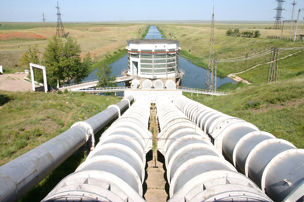
This is one of the world’s largest and unique irrigation and water supply canals of the twentieth century. This artificial river over 1,380 km long crosses the Karakum Desert (Fig. 1). It was designed to cope with the grand problem of conveyance of 13.5 km3 of Amu Darya flow to the water-deficit regions with vast fertile lands. It also supplied water to nearly all industrial centers of Turkmenistan, such as Ashkhabad, Mary, Balkanabat, and Turkmenbashi. This artificial river unites the Amu Darya, Murghab, and Tejen rivers into a single water management system. It also brings irrigation to around one million ha of lands. Four reservoirs 2.5 km3 in capacity each were built on this canal mostly for accumulation of winter flow with its further use during the vegetation (simmer) period [8].

The Karakum Canal in Turkmenistan (http://web3.telecom.tm/photo/anons/1538397618.jpg) [8]
The canal construction was divided into six phases. By 1968 three phases were completed. This project stirred many disputes.
The main argument of opponents to this megaproject was its negative impact on the natural environment. In fact, in engineering terms, it was excellently designed, but the more in-depth understanding of its environmental implications posed many questions although the greater part of them could be answered only after the canal was constructed and put into operation.
It is a well-known fact that the economic effect of the project may be awaited quicker than the environmental implications. The changes in the natural situation are witnessed not at once. They become obvious after slow accumulation of their components and their aggregation, and this process in different physiographical conditions requires different time.
This canal constructed in earth cut without lining run across the Karakum sandy desert as a result the water losses for seepage were enormous. The expectations that natural clogging would resolve this problem failed, at least in the short time period. Its construction led to the formation of filtration lakes, waterlogging, overmoistening, salinization of soils, and quick growth of phreatophytes.
Later on, after 10 years of operation, the scientists of the Institute of Geography of the USSR Academy of Sciences analyzed changes that occurred in the natural environment that were caused mainly by water filtration from the canal bed through its whole run. It was noted that the impacts of the Amu Darya water transfer on the nature of Turkmenia that were assessed in the canal command area had to be taken into consideration in the development of the projects on the partial transfer of the Siberian rivers’ flow to the plains of Kazakhstan and Central Asia [8, 9].
Limited water resources in Central Kazakhstan and the growing water demand for development of rich mineral resources required conveyance here of water from other river basins, first of all, from the Irtysh River, the left tributary of the Ob’ River. The Irtysh basin is the main source of water in Southeastern and Eastern Kazakhstan, and it has strategic importance for water supply of the central and northern areas of the country. The total length of the Irtysh River is 3,712 km of which 405 km run in China. The main tributaries of the Irtysh are Ishim and Tobol rivers which mean annual flow within Kazakhstan is 1.4 and 1.5 km3, respectively.
In the recent years, the sustainable water availability in Central Kazakhstan has been ensured by the Irtysh waters transferred via the Irtysh-Karaganda Canal which construction was started in 1962 and completed in 1974. This canal was the first stage of the largest water management system in Central Kazakhstan. The Irtysh-Karaganda Canal named after K.I. Satpayev 458 km long was the longest artificial river after the Karakum Canal (Karakum River). The canal was 20–50 m wide and 5–7 m deep. Its discharge varied from 76 m3/s in the head to 13 m3/s in its tail. In engineering terms, it was more complicated than the Karakum Canal. This canal is furnished with 22 pumping stations which raised Irtysh water to a height of 418 m to the Shiderty and Nura water divide. The water supply regime is regulated by a system of 14 reservoirs, inverted siphons, water spills, and water outlets. A total of 2.4 km3 of water is taken from the Irtysh per year [6]. In 2002 a branch canal was constructed to the Ishim River and further on to the Vyacheslavovskoye Reservoir to supply water to Astana, the capital of Kazakhstan (in 2019 it was renamed into Nur-Sultan) (Fig. 2).

Irtysh-Karaganda Canal (http://ekaraganda.kz/foto/796516cbb385d57cbb1ba254fef1e89a.jpg)
In 1948, Soviet Academician V.A. Obruchev, the well-known geographer and novelist, wrote to I.V. Stalin about the idea of transfer of Siberian river flow to the south, but Stalin did not pay attention to this project. In the 1950s Kazakh Academician Shafik Chokin returned to this problem. In the 1960s the water use for irrigation in the Central Asian republics had grown immensely due to the population growth and extension of irrigated lands. In these years the first signs of the Aral Sea drying out and the water level drop in the Caspian Sea have been observed. Already that time various research institutes have developed several optional schemes of Siberian rivers water transfer to cope with these issues.
In 1968 the Plenum of Central Committee of the Communist Party of the Soviet Union (CC CPSU) ordered to the State Planning Committee, the USSR Academy of Sciences, and other organizations to develop the scheme of river flow redistribution. In May 1970 CC CPSU and the USSR Council of Ministers passed Resolution No. 612 “On Prospects of Development of Land Reclamation, Regulation and Redistribution of River Flow for 1971-1985” defining there the priority task of transfer of 25 km3 of water per year by 1985 which would make 6–7% of the Ob’ River flow. More than 150 organizations were involved in the preparation of the feasibility report for the transfer project. That time the Irtysh-Karaganda irrigation and water supply canal was considered a part of the project on water conveyance to Central Kazakhstan.
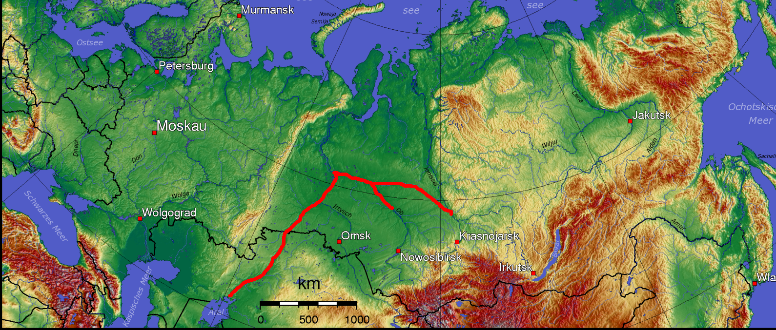
In 1976 at the 25th CPSU Congress, the final design was chosen out of the four proposed alternatives. The decision on launching works for the project was approved. The West-Siberian (Turgai) alternative was given priority. It envisaged a head water intake from the Ob’ River, the world’s fourth river, with the flow of 400 km3 to be constructed near Khanty-Mansiysk where the Irtysh River flows into it. It was considered feasible to convey water along the Lower Irtysh River as far as the head reservoir near Tobolsk City: (1) through the Irtysh channel in the anti-river regime by pumping water through the system of three low-lift waterworks; (2) through the left canal branching off downstream of the Irtysh mouth (from Belogorie village), or (3) by a combined method (anti-river-canal). In case the main waterworks at Tobolsk is constructed without a regulating reservoir, the water into the main transfer canal will be taken from the flow formed in the Upper and Middle Irtysh basin. The admissible water intake in this case depends largely on consumptive water use in the upstream river basin (Fig. 3).

General view of the Siberian-Aral Canal from the Ob’ River to the Aral Sea (http://cdn.mapme.club/images/2195/219513-peresyxanie-aralskogo-morya-odna-iz-uzhasnejshix-ekologicheskix-katastrof-sovremennosti.jpg)
The Siberian-Aral main canal for water redistribution goes from the Tobolsk Reservoir to the Turgai Depression via which in the past the waters impounded by the ancient glacier run from Western Siberia to the Aral Sea. The transferred water is lifted by five pumping stations to the water divide southward of the Kushmurun Lake after which it flows by gravity to the south. This canal that may be also used for navigation crosses the Syr Darya and goes to the Amu Darya. Its length is over 2,200 km, the average depth 12 m, width 200–300 m, the flow velocity 0.6–1.0 m/s, and the carrying capacity 1,150 m3/s. The whole route of the canal goes mainly over a low-lying (to 200 m abs.) plain composed of thick loose sediments. Taking its origin in the forest waterlogged landscapes of the Tyumen Region, it crosses the forest-steppe, steppe, semi-desert, and desert natural zones. In the head part of the route, the Russian regions would receive 4.9 km3 of water and Northern Kazakhstan 3.4 km3, and the Syr Darya and Amu Darya rivers would receive 16.3 km3 for their recharge, including Uzbekistan 10 km3. The design water losses for transportation should be 3 km3 or 12% of the whole volume. The world practice has not known the examples of water transfer in such variegated and contrasting natural conditions.
For consideration of the Feasibility Report “Territorial Redistribution of a Part of Free Flow of the Ob’ and Irtysh Rivers,” the State Expert Commission consisting of the representatives of the USSR Academy of Sciences, the State Committee of the Council of Ministers for Science and Technology, and the USSR State Committee for Architecture and Construction was established at the USSR State Planning Committee which approved this Feasibility Report submitted by the USSR Ministry of Water Economy. However, in August 1986, the special meeting of the CC CPSU Political Bureau decided to abandon this project. Such decision was influenced by the numerous publications, the authors of which spoke against this project and asserted that it was too costly and disastrous for the natural environment. The project was put on the blacklist by the academic publishing “dictatorship” being not very learned in hydraulic construction and land reclamation issues who relied upon fake statistics and intellectual unscrupulousness.
Recently it has become popular the idea that the whole generation of people had grown criticizing these projects and that this negative attitude had been extended to the social and political system of the USSR which contributed to its breakdown [10].
In January 2002 Yury Luzhkov, Mayor of Moscow, made an attempt to revive “the project of the century.” He sent a letter concerning this issue to Russian President Vladimir Putin in which he suggested “having revised the available developments resume consideration of the mutually beneficial use of flood and excessive waters of Siberian rivers for putting into exploitation the unused, but highly productive agricultural lands suitable for irrigation in Russia and Central Asia.” In other words, he called to return to the megaproject on the partial water transfer of Siberian rivers to Central Asia that had been abandoned in 1986 by CC CPSU Political Bureau. He proposed “to return to this project at the lower cost level, but at the higher technological level on the basis of more reasonable policy and actual green thinking …” [11]. There was no response to Luzhkov’s proposal.
In September 2006 in Astana, Kazakhstan President Nursultan Nazarbayev spoke about the necessity to reconsider the redirection of the Siberian rivers to Central Asia. He repeated this idea in 2010 in Ust-Kamenogorsk at the cross border cooperation forum. “In the future this problem may acquire quite a grand scale in the face of the need to provide with drinking water the entire Central Asian region,” said Nursultan Nazarbayev [12]. Earlier, in 2003 the Uzbek President Islam Karimov applied to the Russian leadership with the same proposals.
4 Megaprojects: The Dreams and Reality
The Central Asian countries have been always known for their bent for megaprojects to cope with both national and international issues concerning water management. This is connected with natural and climatic specific conditions as well as social and economic development of states suffering from high water, demographic, and ecological stress. The strategy of further development of these countries is targeted to the maximum possible mobilization of deficit water resources and search and utilization of outside water sources and all the more so, as the modern achievements in science and technology permit to address them.
At the end of the twentieth century, the prospects of the next century as the time of global civilization where such basic principles as harmony, equilibrium, and tolerance should be decisive in attaining the goals of sustainable development were outlined.
In 1977 one of the most active leaders of the Japan business, Chairman of Research Fund of Mitsubishi Corporation Masaki Nakajima, voiced the idea to establish the Global Infrastructure Fund (GIF). The fund concept is based on the globalization philosophy – promotion of global infrastructures within the frame of international cooperation through implementation of giant investment projects going out beyond the borders of national states [13]. In 1991 in his opening speech at the First GIF International Congress held in Atlanta, USA, M. Nakajima said that “we were quickly moving into the absolutely new era of construction of global peace. The GIP founders believe that this fund should become the alternative to superarmament” [14].
The Committee for Global Superproject Study of the International Association of Engineering Consultants has adopted the following criteria: non-realizable by one country; project cost exceeding 10 billion USD; their impact area should cover several countries or a vast territory; support of governmental bodies; and environmentally friendly projects. According to the US Global Development Council, the global projects are the projects of infrastructure or service facilities which implementation requires at least 1 billion dollars or the projects producing enormous global effect.
In view of stagnation of irrigation and drainage activities in Russia, all subsequent projects of the Central Asian countries cloned the Soviet project of transfer of Siberian rivers flow to the south. The first country that suggested the super-mega-futuristic project was Uzbekistan. In 1995 the Uzbek scientists from the Institute of Water Problems investigated the issue of long-time sustainability and reliability of water supply in Central Asia. They formulated the idea to construct the Single Asian Water Management System (SAWMS) that will connect the basins of Central Asian rivers: the Syr Darya in the north with the rivers of the Kara Sea and the Amu Darya in the south with basins of the rivers belonging to the Arabian Sea basin. SAWMS included the interstate mutually beneficial use of a part free flood flow of rivers of the Arabian Sea, in particular the flow from the Indus River basin [15,16,17].
It was envisaged to create the Arabian-Aral Water Transport Route (AAWTR) which would cross Pakistan, Iran, Afghanistan, Turkmenistan, and Uzbekistan. The water would be taken in the Indus lower reaches downstream Sukkur (Pakistan). A cascade of large pumping stations to lift water to a height of 750 m to the Iranian Plateau should be constructed in Baluchistan, Pakistan.
After pump lift the first terminal for handling cargo ships is constructed after which the gravity canal goes on and joins the Harirud River (Afghanistan). Its length is 1,700 km, depth 8–10 m, bottom width 80–100 m, and water edge width 120–130 m. Here the water intake to direct water to the Pakistan national canal is to be constructed with a cascade of hydropower plants compensating electricity consumed for water lifting and a buffer reservoir. AAWTR will be navigable in a stretch as far as the second terminal located at Kushka on the border with Turkmenistan (Fig. 4). The canal carrying capacity is provisionally taken as 60 million tons of cargo per year or 100,000 tons per day on the average in one direction.
The construction of national canals with hydropower plants and buffer reservoirs is planned for irrigation and development of arid territories in Iran (Baluchistan, Sistan, and Horasan), in the Gilgit-Arghandab Valley in Afghanistan. Along the AAWTR route, the recharge of Atrek and Tejen rivers is also possible. The Iranian Plateau and the Turan Depression will be linked via the Murghab River on which a cascade of hydropower plants will be built. Some water of AAWTR from the lower pool of the terminal power plant will be directed to the Kerki area to replenish the Amu Darya flow and to convey water to the operating Karshi main canal.
The AAWTR route may be also directed to the Termez area to replenish the flow of the Amu Darya as well as the Murghab River. The transferred volume will be 30–35 km3 per year. The pump water lift requiring much energy will be to a height of around 700 m.
The total length of the canal will be 2,665 km, of which 1,280 km is in Pakistan, 464 km in Iran, 464 km in Afghanistan, and 457 km in Turkmenistan (compare the canal for transfer of the Ob’ water to the Syr Darya and Amu Darya basins in Central Asia which is 2,550 km long).
The total cost of construction is $30 billion (in the 1990s prices); the construction will take 25–30 years. The average annual costs may amount to $1.0–1.2 billion [16].
Still more global super-mega-project was proposed by D.I. Ryskulov, Doctor of Economics, close associate of Yu.M. Luzhkov, in his report “Transasian Corridor of Development” (TRASCOR) made in Tashkent in 2008. He proposed “to create the meridional geostrategic transport ridge in the Eurasian space poorly developed economically. In other words, this will be the magnificent integrated transport artery including the shipping canal, high-speed automobile highway and railroad connecting the Yamal Peninsular via the Caspian Sea with the Persian Gulf, in short “Arctic – Persian Gulf”.
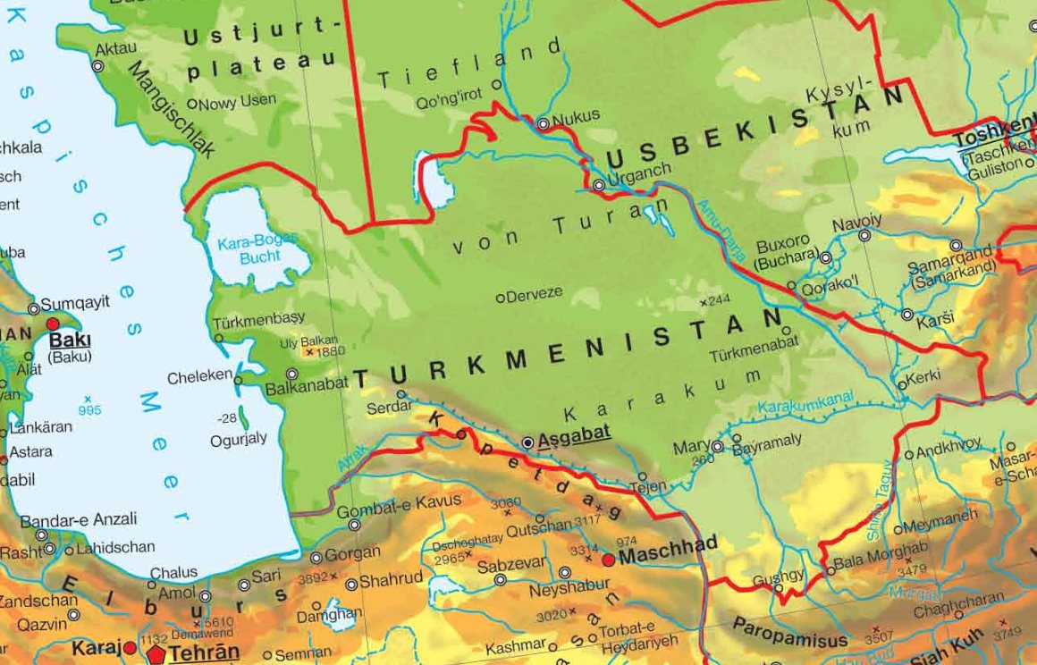
This project is conceived as “the weaving of the global transit network for “catching” benefits and advantages by transport networks” [18]. It relies on the unique experience of the Great Silk Road. The TRASCOR roadmap includes the navigation canal “Asia” connecting the Kara, Aral, Caspian, and Arabian seas. The project envisages the following canal route: port Igarka – The Kara Sea – Gulf of Ob’ – Turgai Depression – crossing of the Syr Darya River to the west of Djusaly – crossing of the Amu Darya River nearby Takhiatash – along Uzboy to Port Turkmenbashi (formerly Krasnovodsk) on the Caspian Sea (Fig. 4).

Water transfer area (http://karteplan.com/turkmenistan/physische-landkarte-von-turkmenistan.jpg)
From here the water route goes on over the Caspian Sea to the south as far as port Enzeli in Iran and then along the canal via Khorramshahr or across the Desht-e Kaevir Desert to the Persian Gulf (Port Bandar Abbas). The total length of this waterway from the Kara Sea to Bandar Abbas will be around 6,000 km. The design depth of the canal “Asia” will be 15 m and the width over 100 m. The water losses for seepage and evaporation are estimated at not higher than 7%.
Two other components of TRASCOR are the high-speed automobile highway Salekhard-Kurgan-Arkalyk-Kzyl-Orda (with branches off to Tashkent and to China via Kyrgyzstan and also a branch to Afghanistan via Kabul or Chābahār and further on to Pakistan)-Dashoguz (with a branch leading to Serakhs and to the Persian Gulf across Iran)-Port Turkmenbashi and the high-speed railroad Salekhard-Kurgan-Arkalyk-Kzyl-Orda (with a branch off to Serakhs and Turkmenbashi). The project designs to create forest shelterbelts 4,000 km long on both sides of TRASCOR. The total construction cost of the waterway Kara Sea-Persian Gulf (including the canal Eurasia), the railroad, and automobile highway with attending facilities may amount to $ 100–150 billion, while the construction will take 15 years; the expected average annual profit is $7–10 billion. The payback period of TRASCOR is about 20–25 years after construction commencement.
If the foregoing projects may be considered as the developments of the future and are probably hardly realizable, the works in Eastern Turkmenistan are already underway on implementation of the grand hydraulic project – creation of the Turkmen Lake “Altyn-Asyr” [19]. It was decided to accumulate the collection and drainage waters (CDW) from irrigated farming that had been recently discharged into the Amu Darya River and the Sarykamysh Lake and to divert and store them in the natural depression of Karashor in the Central Karakums having an elevation of −28 m abs. which roughly corresponds to the current level of the Caspian Sea. This depression locates eastward of the Kara-Bogaz-Gol Bay in the Caspian Sea. Its length is 120 km, width 20 km, and area 2000 km2 (Fig. 5).

The Altyn Asyr Lake (Turkmenistan) (https://turkmenportal.com/images/uploads/blogs/ICC_7128%20(28).JPG)
Irrigation of agricultural lands with the Amu Darya waters generates around 6 km3 of CDW per year, and in addition to CDW formed in the territories in neighboring Uzbekistan on the right bank of the Amu Darya River, their total amount may exceed 10 km3 per year [19]. Some CDW waters were discharged into the Amu Darya, thus deteriorating its water quality and increasing salinity from 0.9 to 1.5 g/L, while some other CDW waters were diverted into the depressions in the Karakum Desert where they flooded and increased salinity of pasturelands reducing their areas and productivity, and still some other waters were diverted into the Sarykamysh Lake being a drainless water body.
If CDW generated in the Khorezm Province of Uzbekistan and having been discharged until now into the Sarykamysh Lake is intercepted and conveyed into the Turkmen Lake, the Sarykamysh Lake inflow may annually lose to 3 km3 of water which certainly will affect its water balance. In 2006 the water area of the Sarykamysh Lake was approximately 4,000 km2.
According to the project, the Altyn Asyr Lake will be filled with drainage waters supplied by two routes – the Dashoguz (northern route) Collector and the Great Turkmen Collector (southern route) (Fig. 5). The northern route should carry CDW from irrigated lands in the Dashoguz Province and a part of CDW of the Khorezm Province in Uzbekistan by the Ozerny (150 m3/s) and Daryalyk (60 m3/s) collectors. The Dashoguz route will go across three natural depressions: Zengi Baba 2.7 km3 in capacity, the Uzyn Shor (0.76 km3), and Atabai Shor (0.02 km3). Before filling, the length of the Altyn Asyr Lake will be 103 km, the width 18.6 km, the average depth 69 m, the water area around 1915.8 km2, and the volume 132 km3. It is planned to convey in it annually up to 10 km3 of CDW, including from Akhala, Mary, and Lebala 3–4 km3 by the Great (Southern) Collector and 6–7 km3 by the Dashoguz (Southern) Collector. To attain the planned CDW inflow into the Altyn Asyr Lake, it will be necessary to increase water supply from Dashoguz having redirected a part of flow from the Sarykamysh Lake into the Northern Collector, including CDW from Khorezm Province in Uzbekistan. However, this diversion currently amounts to 1–2 km3. The lake filling will take 15 years.
Creation of this lake will make a vital input into addressing numerous environmental and economic issues of the country: improve the condition of agricultural lands, ensure water supply of 1.5 million ha of desert pastures, use drainage waters for irrigation of 800 thousand ha of desert lands, stop discharging drainage waters into the Amu Darya, develop fisheries, promote recreational and ecological tourism, and, in general, improve the environmental security of the population.
This project about $4 billion worth is one of the world’s largest in desert development through land reclamation [19]. The future will show how much such engineering solution was well-considered and correct.
5 Conclusions
Great Soviet expert in water management S.L. Vendrov contemplating the reconstruction of rivers in the USSR noted that “in the future it would be necessary to use the flow of northern rivers being remote from places of consumption, but we believed that the objective need in this would arise … mostly in the 21st century” [20]. This was said in 1970.
In any case Russia as a country taking one of the world’s leading positions by river flow will have to take part in addressing water problems of Central Asia. It is quite unlikely that water saving in the water-deficit countries of Central Asia will do much for harmonizing the population growth and distribution and the available natural water resources. Hence, the transformation of the natural regimes of the existing river network will be required.
One of the perspective ways to deal with water issues is the international maneuvering with river flow. This will require quite serious and long-time scientific and engineering analysis of the earlier abandoned projects or consideration of new projects.
The utterly new technologies and territorial redistribution of river flow are two ways that should be considered in the future. They may complement each other depending on the geography of a region. It should be noted that the principally new technologies appear quite seldom. This urges us to undertake more intensive and in-depth development of both ways to resolve the water supply problem. Here first should go the measures for improving the efficiency of water use in the existing water supply and irrigation systems and only after this the choice of schemes for territorial redistribution of river flow.
Today we can name only one not large country in the arid zone that quite successfully realized both ways. This is Israel. This country created a specific natural-technogenic construction on the basis of which the highly productive agrotechnologies are developing. For Israel water is a strategy, security, and independence. In this country the Central Asian slogan “Drop of water – grain of gold” is materialized not in words, but in deeds [21].
River water transfer projects represent in a sense a search of new model of international cooperation and general world management in the conditions of the newly emerging multipolar world.
As well-known American geographers P. James and J. Martin wrote: “we should move ahead not repeating the mistakes of the past, but always with bold pursuit to develop new hypothesis and, at the same time, not be afraid to criticize the already developed hypotheses and may be even abandon them” [22].
References
Voropaev GV, Ratkovich DY (eds) (1985) Problems of territorial redistribution of water resources. Institute of Water Problems. USSR AS, Moscow, p 503
Kurtov AA (2013) Projects of new canals: the potential for cooperation or implicit threat to the Russian interests? Natl Strateg Probl 4:71–90
Orlov AA, Chechevishnikov AP, Chernyavsky SI, Fedorchenko AV (2011) Fresh water issue: global context of the russian policy. Bull MGIMO Univ 3:45–52
Dayer G (2011) Climate wars. Astrel, Moscow, 318pp
MCVC (2018) The future of the Amu Darya Basin in the face of climate changes. USAID, Tashkent, pp 34–87
Sarsembekov TT, Nurushev AN, Kozhakov SE, Ospanov MO (2004) Transboundary rivers use and protection in the Central Asian countries. Almaty, Atamura, pp 67–78
Freykin ZG (1952) The Great Turkmen Canal Amu Darya – Krasnovodsk. AS USSR Publishers, Moscow, p 110
Zonn IS (2014) The karakum canal: artificial river in the desert. In: Zonn IS, Kostianoy AG (eds) The Turkmen Lake Altyn Asyr and water resources in Turkmenistan. Springer, Berlin, pp 95–106
Kuznetsov NT (ed) (1978) The Karakum Canal and environmental changes in its zone of influence. Nauka, Moscow, p 232
Koronkevich NI, Barabanova EA, Georgiady AG, Dolgov SV, Zaitseva IS, Kashutina EA, Melnik KS, Yasinsky SV (2018) Man and water. In: Century of geography. Drofa, Moscow, pp 231–259
Luzhkov YM (2008) Water and peace. Moscow Textbooks, Moscow, 152pp
Nazarbaev NA (2010) Revived the idea of transfer of Siberian river flow to the south. BBC Russian Service: Internet site. September 07. http://www.bbc.co.uk/russian/russia/2010/09/100907_nazarbayev_siberia_rivers.shtml. Accessed 27 May 2019
Zonn IS (1992) Planetary surgery of the 21st century in the desert zone. Desert Dev Probl 3:6–15
Nakajima M (1987) The global infrastructure fund (GIF) concept. Technol Soc 9:77–85
Khamraev NP (1995) Project of irrigation of arid territories in Central Asia. Desert Dev Probl 6:45–56
Khamraev NP (1996) Water resources of central and southern Asia. Joint use scenarios. FAN, Tashkent, 48pp
Zonn IS, Gusarov EA, Zhiltsov SS (2018) The design and engineering intrusion into the Caspian. Post-Soviet Iss 5(2):124–139
Rudashevsky VD, Ryskulov DM (2012) Trans-Caspian development corridor. NG Energia 7:10–12
Zonn IS, Kostianoy AG (2014) The Turkmen Lake Altyn Asyr. In: Zonn IS, Kostianoy AG (eds) The Turkmen Lake Altyn Asyr and water resources in Turkmenistan. Springer, Berlin, pp 159–176
Vendrov SL (1970) Problems of transformation of river systems. Gidrometeoizdat, Leningrad, 236pp
Orlovsky NS, Zonn IS (2018) Water resources of Israel: experience of development. Post-Soviet Iss 5(1):8–36
James P, Martin J (1988) All possible worlds. A history of geographical ideas. Progress, Moscow, 672pp
Acknowledgments
A.G. Kostianoy was partially supported in the framework of the P.P. Shirshov Institute of Oceanology RAS budgetary financing (Project N 149-2019-0004).
Author information
Authors and Affiliations
Corresponding author
Editor information
Editors and Affiliations
Rights and permissions
Copyright information
© 2020 Springer Nature Switzerland AG
About this chapter

.JPG)
Cite this chapter
Zonn, I.S., Kostianoy, A.G., Semenov, A.V. (2020). Water Resource Transfer in Central Asia: Projects, Results, and Perspectives. In: Zonn, I., Zhiltsov, S., Kostianoy, A., Semenov, A. (eds) Water Resources Management in Central Asia. The Handbook of Environmental Chemistry, vol 105. Springer, Cham. https://doi.org/10.1007/698_2020_600
Download citation
DOI: https://doi.org/10.1007/698_2020_600
Published:
Publisher Name: Springer, Cham
Print ISBN: 978-3-030-57985-2
Online ISBN: 978-3-030-57986-9
eBook Packages: Chemistry and Materials ScienceChemistry and Material Science (R0)